Forecasting the Urban Expansion Effects on the Design Storm Hydrograph and Sediment Yield Using Artificial Neural Networks


Abstract
:1. Introduction
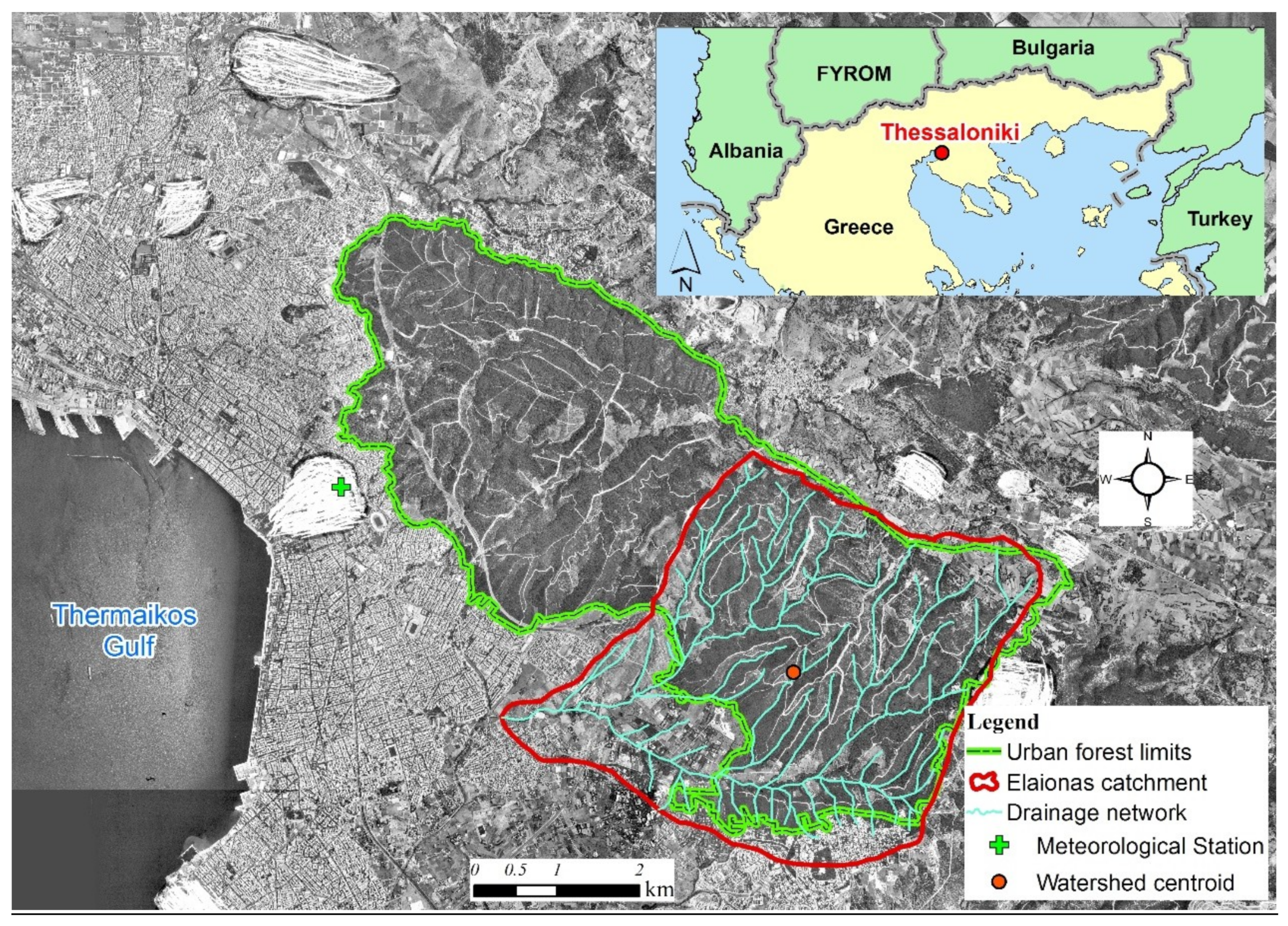
2. Study Area, Datasets and Past Urban Sprawl Description
3. Materials and Methods
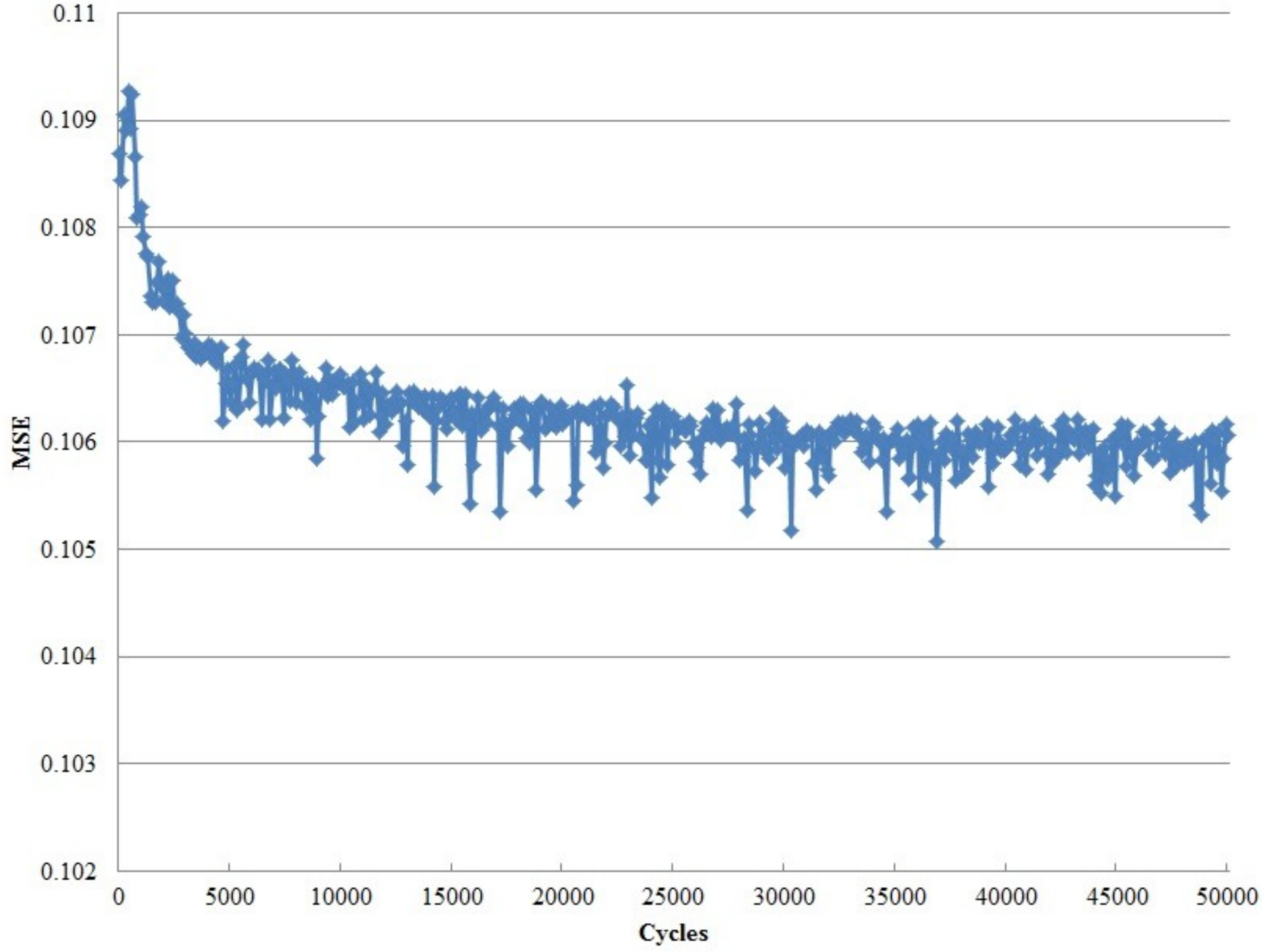
3.1. Future Urban Expansion Prediction Using Artificial Neural Networks and LTM
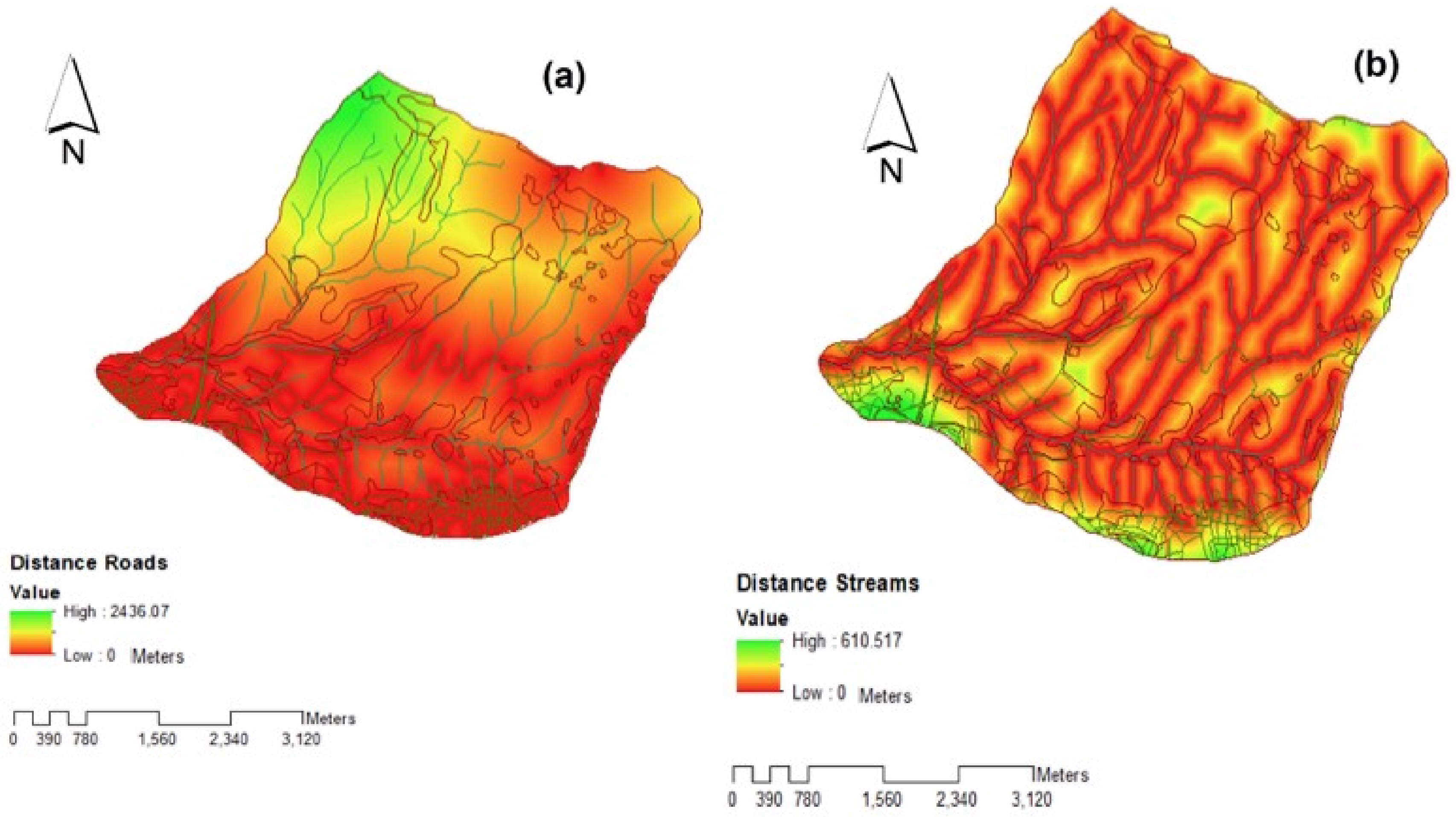
3.2. Hydrologic and Sediment Yield Modelling
4. Results
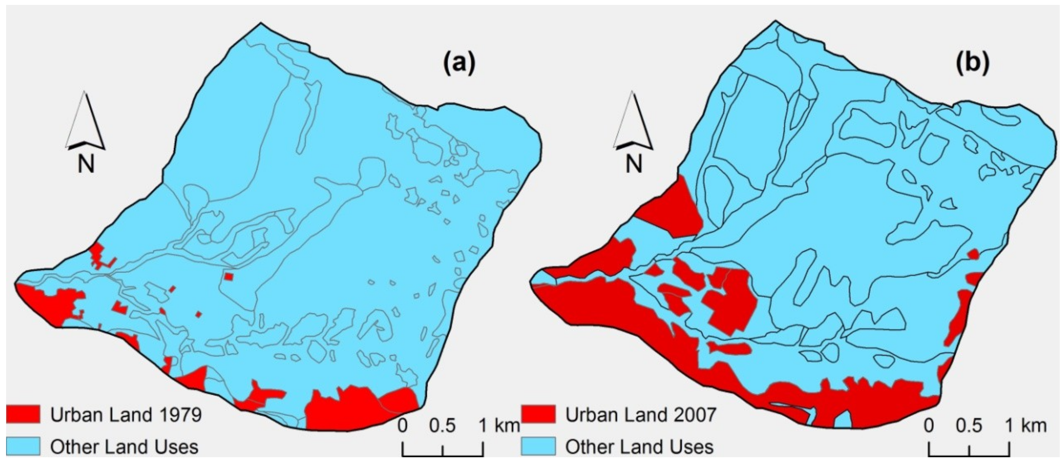
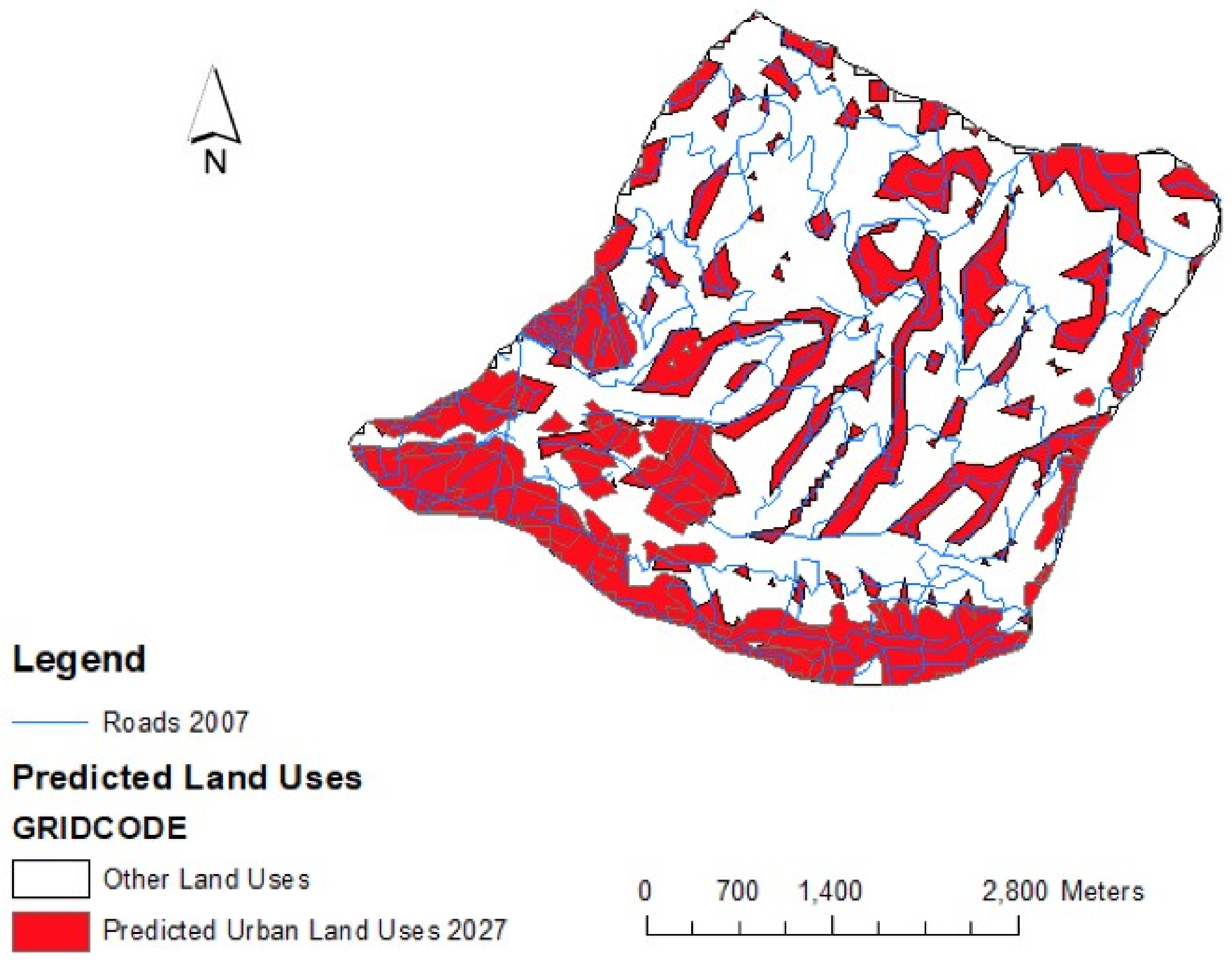
4.1. Future Urban Expansion Prediction
- i = 1, …, c: the common categories of change in both observed change and simulated model run results. There are two categories (i.e., c = 2) categories whose values are predefined ‘0’ (no urban change) and ‘1’ (urban change).
- : the proportion of cells in category i of observed change, taken from the marginal totals of the last column of the contingency matrix.
- : the proportion of cells in category i of simulated model run, taken from the marginal totals of the last row of the contingency matrix.
- : the proportion of cells in the same category, i, on both observed changes and simulated model runs, taken from the diagonal elements of the contingency matrix.
- P(A) = : the fraction of agreement or sensitivity coefficient.
- P(E) = : the expected fraction of agreement subject to the observed distribution.
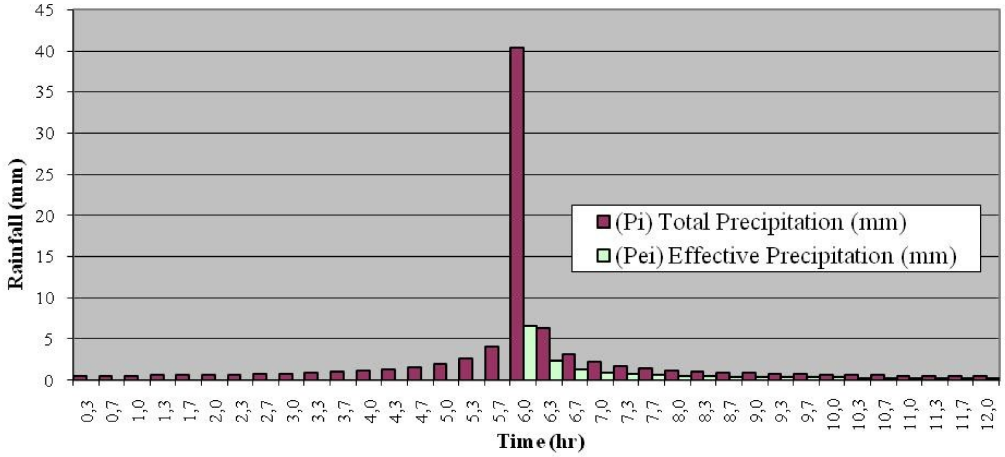
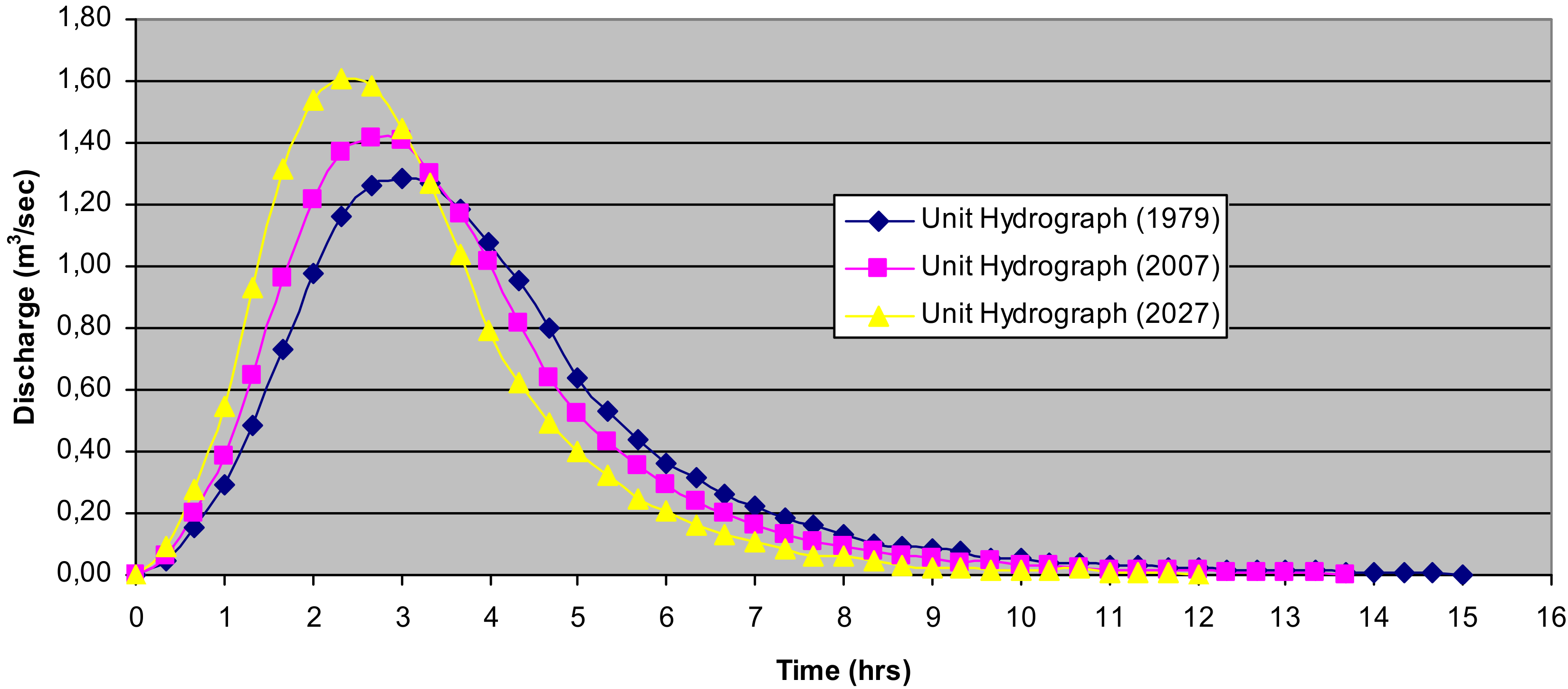
4.2. Hydrologic and Sediment Yield Modelling
5. Discussion
6. Conclusions
Author Contributions
Funding
Acknowledgments
Conflicts of Interest
References
- United Nations. Department of Economic and Social Affairs, Population Division. World Urbanization Prospects: The 2018 Revision. Available online: https://population.un.org/wup/Publications (accessed on 30 September 2018).
- Eurostat. Urban Europe Statistics on Cities, Towns and Suburbs. Available online: https://ec.europa.eu/eurostat/statistics-explained/index.php/Urban_Europe_%E2%80%94_statistics_on_cities,_towns_and_suburbs (accessed on 30 September 2018).
- EPA. Urbanization and Population Change. Available online: https://cfpub.epa.gov/roe/indicator.cfm?i=52 (accessed on 30 September 2018).
- Huang, S.; Taniguchi, M.; Yamano, M.; Wang, C.-H. Detecting urbanization effects on surface and subsurface thermal environment—A case study of Osaka. Sci. Total Environ. 2009, 407, 3142–3152. [Google Scholar] [CrossRef]
- Pauchard, A.; Aguayo, M.; Peña, E.; Urrutia, R. Multiple effects of urbanization on the biodiversity of developing countries: The case of a fast-growing metropolitan area (Concepción, Chile). Biol. Conserv. 2006, 127, 272–281. [Google Scholar] [CrossRef]
- O’Driscoll, M.; Clinton, S.; Jefferson, A.; Manda, A.; McMillan, S. Urbanization Effects on Catchment Hydrology and In-Stream Processes in the Southern United States. Water 2010, 2, 605–648. [Google Scholar] [CrossRef]
- Radice, A.; Longoni, L.; Papini, M.; Brambilla, D.; Ivov Ivanov, V. Generation of a Design Flood-Event Scenario for a Mountain River with Intense Sediment Transport. Water 2016, 8, 597. [Google Scholar] [CrossRef]
- Radice, A.; Rosatti, G.; Ballio, F.; Franzetti, S.; Mauri, M.; Spagnolatti, M.; Garegnani, G. Management of flood hazard via hydro-morphological river modelling. The case of the Mallero in Italian Alps. J. Flood Risk Manag. 2013, 6, 197–209. [Google Scholar] [CrossRef]
- Directive 2007/60/EC of the European Parliament and of the Council of 23 October 2007 on the Assessment and Management of Flood Risks. Available online: http://ec.europa.eu/environment/water/flood_risk/ (accessed on 30 September 2018).
- Longoni, L.; Ivanov, V.I.; Brambilla, D.; Radice, A.; Papini, M. Analysis of the temporal and spatial scales of soil erosion and transport in a mountain basin. IJEGE 2016, 2, 17–30. [Google Scholar] [CrossRef]
- Dow, C.L.; DeWalle, D.R. Trends in evaporation and Bowen ratio on urbanizing catchments in eastern United States. Water Resour. Res. 2000, 36, 1835–1843. [Google Scholar] [CrossRef]
- Stathis, D.; Sapountzis, M.; Myronidis, D. Assessment of land use change effect on a design storm hydrograph using the SCS curve number method. Fresenius Environ. Bull. 2010, 19, 1928–1934. Available online: https://www.prt-parlar.de/download_feb_2010 (accessed on 30 September 2018).
- Arnold, J.G.; Bircket, M.D.; Williams, J.R.; Smith, W.F.; McGi1, H.N. Modelling the effects of urbanization on basin water yield and reservoir sedimentation. Water Resour. Bull. 1987, 23, 1101–1107. [Google Scholar] [CrossRef]
- Pisinaras, V.; Petalas, C.; Gikas, G.D.; Gemitzi, A.; Tsihrintzis, V.A. Hydrological and water quality modelling in a medium-sized basin using the Soil and Water Assessment Tool. Desalination 2010, 250, 274–286. [Google Scholar] [CrossRef]
- National Research Council. Advancing Land Change Modelling: Opportunities and Research Requirements; The National Academies Press: Washington, DC, USA, 2014; pp. 1–152. [Google Scholar] [CrossRef]
- Pontius, R.G.; Boersma, W.; Castella, J.-H.; Clarke, K.; De Nijs, T.; Dietzel, C.; Duan, Z.; Fotsing, E.; Goldstein, N.; Kok, K.; et al. Comparing the input, output and validation maps for several models of land change. Ann. Reg. Sci. 2008, 42, 11–37. [Google Scholar] [CrossRef]
- Searchinger, T.; Heimlich, R.; Houghton, R.A.; Dong, F.X.; Elobeid, A.; Fabiosa, J.; Tokgoz, S.; Hayes, D.; Yu, T.H. Use of US croplands for biofuels increases greenhouse gases through emissions from land use change. Science 2008, 319, 1238–1240. [Google Scholar] [CrossRef] [PubMed]
- Weiss, F.; Leip, A. Greenhouse gas emissions from the EU livestock sector: A life cycle assessment carried out with the CAPRI model. Agric. Ecosyst. Environ. 2012, 149, 124–134. [Google Scholar] [CrossRef]
- Stevenson, J.R.; Villoria, N.; Byerlee, D.; Kelley, T.; Maredia, M. Green revolution research saved an estimated 18 to 27 million hectares from being brought into agricultural production. Proc. Natl. Acad. Sci. USA 2013, 110, 8363–8368. [Google Scholar] [CrossRef]
- Cherubini, F. GHG balances of bioenergy systems—Overview of key steps in the production chain and methodological concerns. Renew. Energy 2010, 35, 1565–1573. [Google Scholar] [CrossRef]
- Schmidinger, K.; Stehfest, E. Including CO2 implications of land occupation in LCAs-method and example for livestock products. Int. J. Life Cycle Assess. 2012, 17, 962–972. [Google Scholar] [CrossRef]
- Schmidt, J.H. Life cycle assessment of five vegetable oils. J. Clean. Prod. 2015, 87, 130–138. [Google Scholar] [CrossRef]
- Audsley, E.; Brander, M.; Chatterton, J.; Murphy-Bokern, D.; Webster, C.; Williams, A. How Low Can We Go? An Assessment of Greenhouse Gas Emissions from the UK Food System and the Scope Reduction by 2050. WWF-UK. 2009. Available online: http://dspace.lib.cranfield.ac.uk/handle/1826/6503 (accessed on 30 September 2018).
- Vellinga, T.V.; Blonk, H.; Marinussen, M.; van Zeist, W.J.; de Boer, I.J.M.; Starmans, D. Methodology Used in FeedPrint: A Tool Quantifying Greenhouse Gas Emissions of Feed Production and Utilization. Wageningen UR Livestock Research. Report 674. 2013. Available online: http://edepot.wur.nl/254098 (accessed on 30 September 2018).
- Persson, U.M.; Henders, S.; Cederberg, C. A method for calculating a land use change carbon footprint (LUC-CFP) for agricultural commodities e applications to Brazilian beef and soy, Indonesian palm oil. Glob. Chang. Biol. 2014, 20, 3482–3491. [Google Scholar] [CrossRef]
- De Rosa, M.; Knudsen, M.T.; Hermansen, J.H. A comparison of Land Use Change models: Challenges and future developments. J. Clean. Prod. 2016, 113, 183–193. [Google Scholar] [CrossRef]
- Pijanowski, B.C.; Gage, S.H.; Long, D.T. A Land Transformation Model: Integrating Policy, Socioeconomics and Environmental Drivers using a Geographic Information System. In Landscape Ecology: A Top Down Approach; Sanderson, J., Ed.; CRC Press: Boca Raton, FL, USA, 1999; 272p, ISBN 9781566703680. [Google Scholar]
- Pijanowski, B.C.; Pithadia, S.; Shellito, B.A.; Alexandridis, K. Calibrating a neural network-based urban change model for two metropolitan areas of the Upper Midwest of the United States. Int. J. Geogr. Inf. Sci. 2005, 19, 197–215. [Google Scholar] [CrossRef]
- Pontius, R.G.; Castella, J.C.; De Nijs, T.; Duan, Z.; Fotsing, E.; Goldstein, N.; Kok, K.; Koomen, E.; Lippitt, C.D.; McConnell, W.; et al. Lessons and Challenges in Land Change Modelling Derived from Synthesis of Cross-Case Comparisons. In Trends in Spatial Analysis and Modelling; Geotechnologies and the Environment; Behnisch, M., Meinel, G., Eds.; Springer: Cham, Switzerland, 2018; Volume 19, pp. 143–164. ISBN 978-3-319-52520-4. [Google Scholar]
- SCS (Soil Conservation Service). SCS National Engineering Handbook, Section 4: Hydrology; Soil Conservation Service: Washington, DC, USA, 1972; pp. 1–44. [Google Scholar]
- Vaššová, D. Comparison of Rainfall-Runoff Models for Design Discharge Assessment in a Small Ungauged Catchment. Soil Water Res. 2013, 8, 26–33. Available online: https://www.agriculturejournals.cz/publicFiles/84405.pdf (accessed on 30 September 2018). [CrossRef]
- Taylan, E.D.; Damcayiri, D. The prediction of runoff data for Kinikli basin by using the precipitation data with WMS. Fresenius Environ. Bull. 2017, 26, 7255–7263. Available online: https://www.prt-parlar.de/download_feb_2017 (accessed on 30 September 2018).
- Williams, J.R. Sediment-Yield Prediction with Universal Equation Using Runoff Energy Factor. In Present and Prospective Technology for Predicting Sediment Yield and Sources; US Department of Agriculture, Agriculture Research Service: Washington, DC, USA, 1975; pp. 244–252. [Google Scholar]
- Sadeghi, S.H.R.; Mizuyama, T. Applicability of the Modified Universal Soil Loss Equation for prediction of sediment yield in Khanmirza catchment, Iran. Hydrol. Sci. J. 2007, 52, 1068–1075. [Google Scholar] [CrossRef]
- Pandey, A.V.; Chowdary, V.M.; Mal, B.C. Sediment yield modelling of an agricultural catchment using MUSLE, remote sensing and GIS. Paddy Water Environ. 2009, 7, 105–113. [Google Scholar] [CrossRef]
- Kaffas, K.; Hrissanthou, V. Computation of hourly sediment discharges and annual sediment yields by means of two soil erosion models in a mountainous basin. Int. J. River Basin Manag. 2017. [Google Scholar] [CrossRef]
- Radice, A.; Giorgetti, E.; Brambilla, D.; Longoni, L.; Papini, M. On Integrated Sediment Transport Modelling for Flash Events in Mountain Environments. Acta Geophys. 2012, 60, 191–213. [Google Scholar] [CrossRef]
- Tang, Z.; Engel, B.A.; Lim, K.J.; Pijanowski, B.C.; Harbor, J. Minimizing the impact of urbanization on long term runoff. J. Am. Water Resour. Assoc. 2005, 41, 1347–1359. [Google Scholar] [CrossRef]
- Wayland, K.G.; Hyndman, D.W.; Boutt, D.; Pijanowski, B.C.; Long, D.T. Modelling the impact of historical land uses on surface-water quality using groundwater flow and solute-transport models. Lakes Reserv. Res. Manag. 2002, 7, 189–199. [Google Scholar] [CrossRef]
- Lin, Y.-P.; Hong, N.-M.; Wu, P.-J.; Wu, C.-F.; Verburg, P.-H. Impacts of land use change scenarios on hydrology and land use patterns in the Wu-Tu catchment in Northern Taiwan. Landsc. Urban Plan. 2007, 80, 111–126. [Google Scholar] [CrossRef]
- Du, J.; Qian, L.; Rui, H.; Zuo, T.; Zheng, D.; Xu, Y.; Xu, C.-Y. Assessing the effects of urbanization on annual runoff and flood events using an integrated hydrological modelling system for Qinhuai River basin, China. J. Hydrol. 2012, 464–465, 127–139. [Google Scholar] [CrossRef]
- Hellenic Statistical Authority. 2011 Population and Housing Census for the Resident, De Jure (Registered) and De Facto population of Greece. Available online: http://www.statistics.gr/en/2011-census-pop-hous (accessed on 30 September 2018).
- Zhang, W.; Montgomery, D.R. Digital elevation model grid size, landscape representation and hydrologic simulations. Water Resour. Res. 1994, 30, 1019–1028. [Google Scholar] [CrossRef]
- Strahler, A.N. Quantitative Geomorphology of Drainage Basins and Channel Networks, Handbook of Applied Hydrology; McGraw-Hill: New York, NY, USA, 1964; pp. 439–476. [Google Scholar]
- Sapountzis, M.; Koniaris, N.; Schizas, A.; Adamidou, M. Analysis of the extreme rainfall events in the catchments “Konstantinidi” and “Anotoumpas” at the urban forest of Thessaloniki. In Proceedings of the 10th International Hydrogeological Congress of Greece, Thessaloniki, Greece, 8–10 October 2014; pp. 267–276. [Google Scholar]
- Koppen, W. Grundriss der Klimakunde; Walter de Gruyter: Berlin, Germany, 1931; pp. 1–44. [Google Scholar]
- Stathis, D.; Mavromatis, T. Characteristics of Precipitation in Thessaloniki Area, North Greece. Fresenius Environ. Bull. 2009, 18, 1–6. Available online: https://www.prt-parlar.de/download_feb_2009 (accessed on 30 September 2018).
- Ballabio, C.; Panagos, P.; Montanarella, L. Mapping topsoil physical properties at European scale using the LUCAS database. Geoderma 2016, 261, 110–123. [Google Scholar] [CrossRef]
- Myronidis, D.; Stathis, D.; Sapountzis, M. Post-Evaluation of Flood Hazards Induced by Former Artificial Interventions along a Coastal Mediterranean Settlement. J. Hydrol. Eng. 2016, 21. [Google Scholar] [CrossRef]
- Koutroumanidis, T.; Ioannou, K.; Arabatzis, G. Predicting fuelwood prices in Greece with the use of ARIMA models, artificial neural networks and a hybrid ARIMA-ANN model. Energy Policy 2009, 37, 3627–3634. [Google Scholar] [CrossRef]
- Ioannou, K.; Arabatzis, G.; Lefakis, P. Predicting the prices of forest energy resources with the use of Artificial Neural networks (ANNs). The case of conifer fuel wood in Greece. J. Environ. Prot. Ecol. 2009, 10, 678–694. [Google Scholar]
- Ioannou, K.; Birbilis, D.; Lefakis, P. A method for predicting the possibility of ring shake appearance on standing chestnut trees (Castaneasativa MILL.). J. Environ. Prot. Ecol. 2011, 12, 295–304. [Google Scholar]
- Koutroumanidis, T.; Ioannou, K.; Zafeiriou, E. Forecasting bank stock market prices with a hybrid method: The case of Alpha bank. J. Bus. Econ. Manag. 2011, 12, 144–163. [Google Scholar] [CrossRef]
- Tang, Z.; Engel, B.A.; Pijanowski, B.C.; Lim, K.J. Forecasting land use change and its environmental impact at a catchment scale. J. Environ. Manag. 2005, 76, 35–45. [Google Scholar] [CrossRef]
- Skapura, D. Building Neural Networks, 1st ed.; ACM Press: New York, NY, USA, 1996; ISBN 13 978-0201539219. [Google Scholar]
- Zell, A.; Mamier, G.; Vogt, M.; Mache, N.; Hübner, R.; Döring, S.; Herrmann, K.; Soyez, T.; Schmalzl, M.; Sommer, T.; et al. Stuttgart neural network simulator. In Neural Network Simulation Environments; Skrzypek, J., Ed.; Springer: Boston, MA, USA, 1994; Volume 254, pp. 165–186. ISBN 978-1-4613-6180-0. [Google Scholar]
- Argyrakis, P. Neural Networks and Applications; Hellenic Open University: Patras, Greece, 2001. (In Greek) [Google Scholar]
- Brown, D.; Pijanowski, B.; Duh, J. Modelling the Relationships between Land Use and Land Cover on Private Lands in the Upper Midwest. J. Environ. Manag. 2001, 59, 247–263. [Google Scholar] [CrossRef]
- Pijanowski, B.C.; Alexandridis, K.T.; Mueller, D. Modeling urbanization in two diverse regions of the world. J. Land Use Sci. 2006, 1, 83–108. [Google Scholar] [CrossRef]
- Myronidis, D.; Fotakis, D.; Sgouropoulou, K.; Sapountzis, M.; Stathis, D. Checking a culvert suitability for flood wave routing within the framework of the EU flood directive. In Proceedings of the 7th International Conference on Information and Communication Technologies in Agriculture, Food and Environment, Kavala, Greece, 17–20 September 2015; pp. 146–153. [Google Scholar]
- Methods, H.; Dyhouse, G.; Hatchett, J.; Benn, J. Floodplain Modeling Using HEC-RAS; Haestad Methods, Inc: Waterbury, CT, USA, 2003; ISBN 978-0971414105. [Google Scholar]
- Myronidis, D.; Fotakis, D. Utilizing 3D solid modelling tools for simplified designing of a small concrete Gravity Dam. Int. J. Sustain. Agric. Manag. Inform. 2015, 1, 351–357. [Google Scholar] [CrossRef]
- Chow, V.T.; Maidment, D.R.; Mays, L.W. Applied Hydrology; McGraw-Hill Book Company: New York, NY, USA, 1988; ISBN 0070108102. [Google Scholar]
- Mishra, A.; Kar, S.; Singh, V.P. Prioritizing Structural Management by Quantifying the Effect of Land Use and Land Cover on Catchment Runoff and Sediment Yield. Water Resour. Manag. 2007, 21, 1899–1913. [Google Scholar] [CrossRef]
- Mongil-Manso, J.; Navarro-Hevia, J.; Díaz-Gutiérrez, V.; Cruz-Alonso, V.; Ramos-Díez, I. Badlands forest restoration in Central Spain after 50 years under a Mediterranean-continental climate. Ecol. Eng. 2016, 97, 313–326. [Google Scholar] [CrossRef]
- Xiang-zhou, X.; Hong-wu, Z.; Ouyang, Z. Development of check-dam systems in gullies on the Loess Plateau, China. Environ. Sci. Policy 2004, 7, 79–86. [Google Scholar] [CrossRef]
- Gumbel, E.J. Statistics of Extremes; Columbia University Press: New York, NY, USA, 1958; ISBN 0486436047. [Google Scholar]
- Sutcliffe, J.V. Methods of Flood Estimation: A Guide to the Flood Studies Report; IH Report No. 49; Institute of Hydrology: Wallingford, UK; 50p, Available online: http://nora.nerc.ac.uk/id/eprint/5776 (accessed on 30 September 2018).
- USDA/NRC. Urban Hydrology for Small Catchments TR-55; Technical Release 55; Washington, DC, USA. Available online: https://www.nrcs.usda.gov/Internet/FSE_DOCUMENTS/stelprdb1044171.pdf (accessed on 30 September 2018).
- Al-Zahrani, M.; Al-Areeq, A.; Sharif, H.O. Estimating urban flooding potential near the outlet of an arid catchment in Saudi Arabia. Geomat. Nat. Hazards Risk. 2017, 8, 672–688. [Google Scholar] [CrossRef]
- Ponce, V.M. Engineering Hydrology: Principles and Practice, 1st ed.; Prentice Hall: Englewood Cliffs, NJ, USA, 1989; 640p, ISBN 978-0132778312. [Google Scholar]
- Moench, A.F.; Kisiel, C.C. Application of the convolution relation to estimating recharge from an ephemera stream. Water Resour. Res. 1970, 6, 1087–1094. [Google Scholar] [CrossRef]
- Bruen, M.; Dooge, J.C.I. An efficient and robust method for estimating unit hydrograph ordinates. J. Hydrol. 1984, 70, 1–24. [Google Scholar] [CrossRef]
- Wischmeier, W.H.; Smith, D.D. Predicting Rainfall Erosion Losses—A Guide to Conservation Planning; Agricultural Handbook No. 537; USDA; Forest Service: Washington, DC, USA. Available online: https://data.globalchange.gov/report/usda-aghandbook-537 (accessed on 30 September 2018).
- Rawls, W.J.; Brakensiek, D.L.; Saxton, K.E. Estimation of soil water properties. Trans. ASAE 1982, 25, 1316–1320. [Google Scholar] [CrossRef]
- Panagos, P.; Meusburger, K.; Ballabio, C.; Borrelli, P.; Alewell, C. Soil erodibility in Europe: A high-resolution dataset based on LUCAS. Sci. Total Environ. 2014, 479–480, 189–200. [Google Scholar] [CrossRef]
- Moore, I.; Burch, G. Physical basis of the length-slope factor in the Universal Soil Loss Equation. Soil Sci. Soc. Am. J. 1986, 50, 1294–1298. Available online: https://dl.sciencesocieties.org/publications/sssaj/pdfs/50/5/SS0500051294 (accessed on 30 September 2018). [CrossRef]
- Moore, I.; Burch, G. Modelling erosion and deposition: Topographic effects. Trans. ASAE 1986, 29, 1624–1630. [Google Scholar] [CrossRef]
- Morgan, R. Soil Erosion and Conservation, 3rd ed.; Blackwell Publishing: Malden, MA, USA, 2005; 316p, ISBN 978-1405117814. [Google Scholar]
- Panagos, P.; Van Liedekerke, M.; Jones, A.; Montanarella, L. European Soil Data Centre: Response to European policy support and public data requirements. Land Use Policy 2012, 29, 329–338. [Google Scholar] [CrossRef]
- Pijanowski, B.C.; Brown, D.G.; Shellito, B.A.; Manikd, G.A. Using neural networks and GIS to forecast land use changes: A Land Transformation Model. Comput. Environ. Urban Syst. 2002, 26, 553–575. [Google Scholar] [CrossRef]
- Tayyebi, A.; Delavar, M.R.; Saeedi, S.; Amini, J.; Alinia, H. Monitoring land use change by multi-temporal landsat remote sensing imagery. In Proceedings of the ISPRS Archives, Beijing, China, 3–11 July 2008; Volume XXXVII-B7, pp. 1037–1042. Available online: http://www.isprs.org/proceedings/XXXVII/congress/7_pdf/5_WG-VII-5/54.pdf (accessed on 30 September 2018).
- Vafeidis, A.T.; Koukoulas, S.; Gatsis, I.; Gkoltsiou, K. Forecasting Land Use Changes with the Use of Neural Networks and GIS. In Proceedings of the IEEE International Geoscience and Remote Sensing Symposium, Barcelona, Spain, 23–28 July 2007. [Google Scholar] [CrossRef]
- Zope, P.E.; Eldho, T.I.; Jothiprakash, V. Hydrological impacts of land use–land cover change and detention basins on urban flood hazard: A case study of Poisar River basin, Mumbai, India. Nat. Hazards. 2017, 87, 1267–1283. [Google Scholar] [CrossRef]
- Grimaldi, S.; Petroselli, A.; Serinaldi, F. Design hydrograph estimation in small and ungauged catchments: Continuous simulation method versus event-based approach. Hydrol. Process. 2011, 26, 3124–3134. [Google Scholar] [CrossRef]
- Koutsoyiannis, D.; Xanthopoulos, T. Engineering Hydrology. Available online: http://hdl.handle.net/11419/5888 (accessed on 30 September 2018).
- Cambazoglu, M.; Gogus, M. Sediment Yields of Basins in the Western Black Sea Region of Turkey. Turk. J. Eng. Environ. Sci. 2004, 28, 355–367. Available online: http://journals.tubitak.gov.tr/engineering/issues/muh-04-28-6/muh-28-6-2-0403-8.pdf (accessed on 30 September 2018).


| Rainfall Duration | Return Period (T) | Year | CN | Pe | Peak Discharge (m3/s) | Time of Peak (h) | Discharge Volume (m3) | Sediment Volume (t/ha) |
|---|---|---|---|---|---|---|---|---|
| 6 h | Q50 | 1979 | 65 | 8.4 | 9.1 | 3.6 | 156,381 | 0.08 |
| Q50 | 2007 | 69 | 11.7 | 13.8 | 3.3 | 217,352 | 0.19 | |
| Q50 | 2027 | 75 | 17.8 | 23.4 | 2.6 | 330,332 | 0.47 | |
| Q100 | 1979 | 65 | 11.8 | 12.9 | 3.6 | 220,394 | 0.12 | |
| Q100 | 2007 | 69 | 15.8 | 18.7 | 3.3 | 293,242 | 0.27 | |
| Q100 | 2027 | 75 | 22.9 | 30.5 | 2.6 | 424,816 | 0.63 | |
| 12 h | Q50 | 1979 | 65 | 13.2 | 12.0 | 6.7 | 245,740 | 0.12 |
| Q50 | 2007 | 69 | 17.5 | 17.6 | 6.3 | 323,359 | 0.27 | |
| Q50 | 2027 | 75 | 25.0 | 29.1 | 5.6 | 461,781 | 0.64 | |
| Q100 | 1979 | 65 | 17.4 | 16.1 | 6.7 | 322,184 | 0.16 | |
| Q100 | 2007 | 69 | 22.3 | 22.8 | 6.3 | 411,723 | 0.36 | |
| Q100 | 2027 | 75 | 30.7 | 36.4 | 5.6 | 568,037 | 0.81 | |
| 24 h | Q50 | 1979 | 65 | 19.2 | 15.2 | 12.6 | 350,131 | 0.17 |
| Q50 | 2007 | 69 | 24.4 | 21.8 | 12.0 | 450,060 | 0.37 | |
| Q50 | 2027 | 75 | 33.2 | 35.0 | 11.6 | 614,843 | 0.83 | |
| Q100 | 1979 | 65 | 24.6 | 19.9 | 12.3 | 454,314 | 0.22 | |
| Q100 | 2007 | 69 | 30.5 | 27.9 | 12.0 | 562,457 | 0.48 | |
| Q100 | 2027 | 75 | 40.4 | 43.3 | 11.6 | 747,490 | 1.05 |
© 2018 by the authors. Licensee MDPI, Basel, Switzerland. This article is an open access article distributed under the terms and conditions of the Creative Commons Attribution (CC BY) license (http://creativecommons.org/licenses/by/4.0/).
Share and Cite
Myronidis, D.; Ioannou, K. Forecasting the Urban Expansion Effects on the Design Storm Hydrograph and Sediment Yield Using Artificial Neural Networks. Water 2019, 11, 31. https://doi.org/10.3390/w11010031
Myronidis D, Ioannou K. Forecasting the Urban Expansion Effects on the Design Storm Hydrograph and Sediment Yield Using Artificial Neural Networks. Water. 2019; 11(1):31. https://doi.org/10.3390/w11010031
Chicago/Turabian StyleMyronidis, Dimitrios, and Konstantinos Ioannou. 2019. "Forecasting the Urban Expansion Effects on the Design Storm Hydrograph and Sediment Yield Using Artificial Neural Networks" Water 11, no. 1: 31. https://doi.org/10.3390/w11010031
APA StyleMyronidis, D., & Ioannou, K. (2019). Forecasting the Urban Expansion Effects on the Design Storm Hydrograph and Sediment Yield Using Artificial Neural Networks. Water, 11(1), 31. https://doi.org/10.3390/w11010031