Review

Woody Plant Encroachment Impacts on Groundwater Recharge: A Review

1
Red River Research Station, Louisiana State University Agricultural Center, Bossier City, LA 71112, USA
2
Department of Natural Resource Ecology and Management, Oklahoma State University, Stillwater, OK 74078, USA
3
Department of Rangeland Ecology and Management, Texas A&M University, College Station, TX 77843, USA
4
Boone Pickens School of Geology, Oklahoma State University, Noble Research Center, Stillwater, OK 74078, USA
*
Author to whom correspondence should be addressed.
Water 2018, 10(10), 1466; https://doi.org/10.3390/w10101466
Submission received: 1 September 2018 / Revised: 14 October 2018 / Accepted: 15 October 2018 / Published: 17 October 2018
(This article belongs to the Special Issue Ecohydrology of Woodlands and Savannas)

Abstract

:
Woody plant encroachment has profound impacts on the sustainable management of water resources in water-limited ecosystems. However, our understanding of the effects of this global phenomenon on groundwater recharge at local and regional scales is limited. Here, we reviewed studies related to (i) recharge estimation methods; (ii) mechanisms by which woody plants impact groundwater recharge; (iii) impacts of woody plant on recharge across different soil and geology; (iv) hydrological repercussions of woody plant removal; and (v) research gaps and needs for groundwater studies. We identified six different methods: water balance, water table, isotopes, chloride mass balance, electrical geophysical imaging, and modeling were used to study the impact of woody encroachment on groundwater. Woody plant encroachment could alter soil infiltration rates, soil water storage, transpiration, interception, and subsurface pathways to affect groundwater recharge. The impact is highly variable, with the extent and the magnitude varying across the soil, substrate, plant cover, and topographic locations. Our review revealed mixed effects of woody plant removal on groundwater recharge. Studies of litter interception, root water uptake, soil moisture dynamics, and deep percolation along with the progression of woody plant encroachment are still limited, warranting further experimental studies focusing on groundwater recharge. Overall, information about woody plant encroachment impacts on groundwater resources across a range of scales is essential for long-range planning of water resources.

1. Introduction

Woody plant encroachment refers to an increase in density, cover, and biomass of shrubs and trees into areas where they were not present previously [1,2]. Woody plant encroachment is synonymously used for scrub thickening, woody weed encroachment [3], woody thickening [2], shrub invasion, shrub proliferation [4], shrub encroachment [5], woody plant expansion, and xerification [6]. Some documented encroaching woody plant species include Acacia erubescens, Acacia erioloba, Acacia fleckii, Acacia karoo, Acacia mellifera, Acacia nigrescens, Acacia tortilis, Acacia Senegal, Boscia albitrunca, Dichrostachys cinerea, Grewia flava, Euclea undulata, Maytenus heterophylla, Maytenus senegalensis, Peltophorum africanum, Terminalia sericea, and Ziziphus mucronata, in Africa [7], Elaeagnus angustifolia, Juniperus ashei, Juniperus deppeana, Juniperus osteosperma, Juniperus pinchotii, Juniperus virginiana, Larrea tridentate, Prosopis glandulosa, Tamarix ramosissima, and chaparral plant species, in the United states (US) [8,9,10,11], Baccharis uncinella, and Calea phyllolepis in Brazil [12], Cistus landanifer and Retama sphaerocarpa in Spain [13], Acacia longifolia, Allocasuarina littoralis, Chrysanthemoides monilifera, Dodonaea viscosa ssp. angustissima, Dodonaea viscosa ssp. spatulata, artemisiodes ssp. filifolia, Eremophila sturtii, Eremophila mitchellii, Eucalyptus camaldulensis, Eucalyptus largiflorens, Eucalyptus melliodora, Eucalyptus microcarpa, Leptospermum laevigatum, and Polygala myrtifolia Senna artemisiodes nothosubsp. Artemisiodes in Australia [3,14], and Caragana microphylla in China [15]. Woody plant encroachment has been observed in many regions of the world over the past 150 years including in non-forest biomes in sub-Saharan Africa [16] and Brazil [12], rangelands [8] and riparian gallery forest [17] in the Great Plains, USA, lowland woodland and costal ecosystems in Australia [14], open woodlands (e.g., Iberian dehesas) in the Mediterranean [13], and the Inner Mongolia grassland of China [15]. In North America, the mean annual woody encroachment rate range from 0.1 to 2.3% [18]. Similarly, the annual rate of encroachment ranges from 0.1 to 0.4% in Africa, 0.1 to 0.7% in Australia, and 0.4 to 1.1% cover in South America [19]. In sub-Saharan Africa, woody plant encroachment in non-forest biomes has increased by 8% since the 1980’s [16].
The drivers and constraints of woody plant encroachment are multifarious and interact at various spatio-temporal scales [9,18,20,21,22,23]. Successful establishment and proliferation of woody species in grasslands and savannas have been attributed to fire suppression, overgrazing, land fragmentation, change in atmospheric chemistry, and various combinations and interactions of those factors [24,25,26]. While factors such as fire, grazing, and differential soil properties affect the locality and rate of woody plant encroachment, the upper limit of this physiognomic transformation is controlled by mean annual precipitation [27]. In sub-Saharan Africa, increases in rainfall and herbivore density per unit area along with a decrease in burned areas were linked to the increase in woody plant cover [16]. Woody plant encroachment in central Spain was ascribed to natural regeneration of trees [28], and in Australia, to a long history of grazing, selective logging, and soil disturbance [29].
Woody plant encroachment has important hydrological implications [9]. Of particular concern is its impact on deep drainage and groundwater recharge [30,31,32]. As such, this paper provides a holistic review of published research on how woody plant encroachment has impacted deep drainage and groundwater recharge in different parts of the globe. This review also provides an overview of available tools and methods that have been used to estimate deep drainage and groundwater recharge potential associated with woody plant encroachment.
To this end, we conducted a literature database search in web of science (http://apps.webofknowledge.com) database (Science Citation Index Expanded (SCI-EXPANDED)-1900–2018) and Google Scholar using key words “groundwater recharge”, “recharge”, “deep percolation”, and “drainage” in combination with “woody plants”, “shrub encroachment”, “woody plant invasion”, “woody plant encroachment”, “shrub invasion”, “woody expansion”, “woody plant removal”, and “brush management” (Figure 1). A total of 110 articles were retrieved, of which 20 paper were related to woody plant encroachment impact on drainage, 13 papers were related to woody plant encroachment impacts on groundwater recharge, 7 papers discussed shrub encroachment impacts on recharge, and another 7 papers were related to woody plant removal and brush management impacts on groundwater recharge. For more details on key words combination and number of retrieved papers, refer to Figure 1. Additionally, we synthesized information from other (non-encroachment related) vegetation water use studies for better understanding of the vegetation impact on groundwater recharge.

2. Groundwater Recharge and Estimation Methods

Groundwater, the water that flows or seeps downward and fills porous spaces in soil or geologic strata, accounts for 99% of the earth’s liquid fresh water, and provides drinking water to more than two billion people and irrigation water to 38% of the global croplands [33,34]. The total volume of groundwater is estimated at 22.6 million km3 in the upper two kilometers of the continental crust [35]. Table 1 shows groundwater extraction in ten major countries for different sectors. Global water use for irrigation accounts for >70% of groundwater withdrawal every year [36]. Groundwater withdrawal at rates higher than natural renewal rates has caused aquifer depletion in different parts of the world [34]. For example, total groundwater depletion in subhumid to arid regions worldwide increased from 126 km3 year−1 in 1960 to 283 km3 year−1 in 2000 [37]. Total groundwater depletion in the USA is estimated at 32 km3 per year−1 [37]. Groundwater depletion reduces groundwater discharge to streams and reduces yields from water wells, increases pumping cost, impairs water quality, and negatively affects terrestrial and aquatic ecosystems [38].
Groundwater recharge or deep drainage is the downward movement of water from the surface to the saturated zone. In vadose zone studies, “recharge” is synonymously used for “net infiltration”, “drainage”, “percolation”, and “residual flux” to connote water movement below the rooting zone [39]. Direct or diffuse recharge refers to precipitation water percolating vertically through the unsaturated zone [40,41]. Indirect recharge refers to concentrated or localized recharge from surface depression [40]. Groundwater recharge depends on numerous factors such as climate, land use and land cover, geology, soil texture and structure, irrigation water use, among others. These factors may work independently to influence recharge or may work in concert, interacting in complex ways to affect recharge. Quite directly, increased rainfall, in general, translates into increased recharge. More complex, a change in land cover may alter the land surface-atmosphere interactions and therefore the groundwater recharge [6,31,41], while a complete conversion of grassland to woodland at a regional scale could not only reduce recharge but also feedback to influence the regional climate [42] leading to further changes in recharge potential. In arid and semiarid regions, woody plants generally develop more extensive root systems in subsoils to meet the increase in transpiration demand and consequently these woody plants decrease the potential for local recharge of groundwater. Groundwater recharge varies across and between the seasons. An isotopic analysis of precipitation and groundwater from 54 global locations revealed higher groundwater recharge ratios during winter in arid and temperate climates and during wet seasons in tropical climates [43].
Different methods to quantify groundwater recharge have been widely discussed in past reviews [39,40,44], but these reviews did not emphasize quantification in landscapes undergoing woody encroachment. Groundwater recharge monitoring techniques, based on surface-water, include water balance, channel-water budget, seepage meters, baseflow discharge, heat tracers, stable isotopes, and rainfall-runoff modeling. Techniques based on unsaturated zone studies include lysimeters, zero-flux plane, Darcy’s law, tracers (bromide, 3H and dyes), chloride mass balance, geophysical imaging, and unsaturated-zone modeling. Techniques based on saturated zone studies include the water table fluctuation method, tracers, chloride mass balance, and numerical modeling [39,44]. In this paper, we provide a summary of the frequently used techniques (Table 2) to quantify groundwater recharge in the context of woody plant encroachment.

2.1. Water Balance Method

Water balance method is a residual approach of recharge estimation. In this method, recharge is estimated as the difference between the input of precipitation and output by evapotranspiration and runoff after accounting for the change in soil water in the unsaturated zone.
G = P − ET − Q − delta S
where, G = groundwater recharge, P = precipitation, ET = evapotranspiration, Q = runoff, and delta S = change in soil water storage. Further,
ET = I + E + T
where I = water intercepted by the canopy, E= evaporation from soil, and T = water transpired by plants. Weltz and Blackburn [45] evaluated different components of water balance in the Eastern Rio Grande Plain of Texas to understand the impact of vegetation manipulation on water yield. Results showed that replacing shrub by grasses had a marginal impact on water yield and minimal increase in percolation. Wilcox et al. [46] measured long-term water balance in a semiarid mesquite rangeland undergoing redberry juniper invasion. Results showed that 99% of precipitation was lost to evapotranspiration, and relatively low percolation occurred below one-meter depth of soil. Huxman et al. [9] used the water balance model to discern the impacts of woody plants on different water balance components in water-limited ecosystems. They reported that woody encroachment could potentially increase water loss by transpiration that would otherwise be available for recharge. In drylands, ET is frequently >90% of P, and as such, there is little rainwater left available for recharge. Therefore, it is imperative to be able to adequately measure the recharge to the system. While rainfall and runoff can be fairly accurately quantified, errors in the estimates of evapotranspiration and water storage change in the unsaturated zone will translate into error in the recharge estimate [40].

2.2. Water Table Method

The water table method has been used since the 1920’s to estimate groundwater recharge [47]. Measurements of the rise and fall of water table can be used to estimate the recharge or discharge of groundwater for a site [48]. The underlying assumption is that the water level rise is driven by rainfall recharging the aquifer. Therefore, a rise in the water level can be inferred to be recharge arriving at water table [40,47]. The fluctuation in the water table is affected by land use and land cover changes, which modify the atmospheric water fluxes and the spatial and temporal heterogeneity of soil moisture. For additional details about the method, see Healy and Cook [47].
Oliveira et al. [49,50] monitored groundwater recharge in Brazilian cerrado using water table method. Water table fluctuation measured through a pressure sensor in a 42-m deep well from December 2011 to July 2014 in an undisturbed cerrado showed no evidence of net groundwater table changes. Jobbagy and Jackson [51] reported that a Eucalyptus plantation reduced groundwater recharge, and decreased water table by 38 cm compared to adjacent grassland during a two-year period in the Argentine Pampas. Acharya et al. [30] monitored water levels of perched aquifers under grassland and grassland encroached by Juniperus virginiana (Eastern redcedar) in the South-Central Great Plains, USA. They found that water level was higher under grassland than under Eastern redcedar woodland; this observation indicates that woody plants are likely to decrease water table in a perched aquifer. These results also suggest that woody plants may reduce or have no effect on groundwater recharge. Indeed, the influence of vegetation on groundwater recharge depends on the thickness of the vadose zone in rangelands with shallow water tables [51,52], site and climate, among others. Piezometric data and water table method are best applied to areas with shallow water tables [47]. However, it may be difficult to discern land use effects [53], and account for the steady recharge rate [47]. Additionally, the water table fluctuation method requires close monitoring of groundwater wells and the volume of water yielded from soil or rock through gravity drainage [40]. Sometimes, air trapped between wetting font and water table, “Lisse effect”, may cause a rise in water table, and be mistaken for recharge. The water table method is inadequate in systems where activities like large-scale pumping are ongoing [54].

2.3. Isotopes

The commonly used isotopes in groundwater studies include 3H, 2H, 18O, 14C, 13C, 36Cl, and 15N. The stable isotopes of O and H are increasingly being used to evaluate sources of plant water, plant water use, the mechanisms and pattern of groundwater recharge, and the water flow paths in lands experiencing woody encroachment [55,56,57,58]. Comparison of the isotopic composition of plant xylem water with soil water from different depths helps to define soil water use. McDonnell [59] indicated potential use of isotopes to disentangle water sources from two worlds: (i) Water that is used by trees with no contribution to runoff/streamflow and (ii) mobile water contributing to infiltration, runoff, and recharge.
Examining the isotopic compositions of water from different sources provides important information on groundwater recharge. Precipitation naturally differs in isotopic composition resulting in distinctive isotopic signatures of groundwater [60]. The isotopic values of groundwater can be co-related to the water table. For example, a decrease in δ18O value may indicate a drop in the water table. Isotopic studies on plant water use indicate differential water use pattern and effect on recharge among plant species. Rossatto et al. [56] used δ18O and δ2H in a neotropical savanna and found that woody plants use water from deeper soil layers than do grasses. However, in another study, no difference was observed in depth of water source used during late summer/early fall among co-occurring woody plants Prosopis glandulosa and Zanthoxylum fagara, although rooting depth differed [61]. Evaristo and McDonnell [58] conducted a meta-analysis on plant xylem water stable isotope to understand plant water use, and indicated that plants use 37% of groundwater globally. Barbeta and Penuelas [57] compiled and analyzed 35 isotopic studies to understand groundwater use and reported that groundwater is most likely used by plants in areas with lower precipitation and during dry seasons.
Use of isotopes is relatively advantageous than water balance method because they often rely on long-term water fluxes compared with a water balance method. The isotopic method avoids frequent field visit, but the analyses required by the method are rather costly [62]. Overall, isotopic analysis of plant and soil water could help better understand water extraction strategies of occurring plant species and the implication for the downward flux of water into the deep soil, but hydraulic redistribution of deep soil moisture and their potential effect on isotope composition, if any, must be accounted for [61].

2.4. Chloride Mass Balance

Chloride is a conservative anion and, as such, it neither leaches nor gets absorbed by soil particles and sediments [62,63,64,65]. Chloride mass balance (CMB) is based on several assumptions as documented by Gaye and Edmunds [63] and Sibanda et al. [64]. Some examples of these assumptions include: (a) Net change in storage of Cl in the unsaturated zone is zero during integration time; (b) Cl mass flux over time is constant; (c) there is no unaccounted Cl input from external or groundwater sources such as weathering and dissolution of minerals; and (d) the flux of Cl due to wet and dry deposition at the surface is equivalent to the flux beneath the root zone.
Using CMB, recharge is determined by the following equation:
G = P × Clp/Cls
P is the average annual rainfall (mm year−1), Clp is the average Cl input from all sources (mg L−1), Cls is the average Cl concentration of pore water below root zone (mg/L), and G is the average annual recharge rate (mm year−1) [65,66]. Cls is calculated by dividing soil Cl concentration (in mg/L) by gravimetric water content (in mm3/mm3) [66].
CMB provides point-scale recharge estimates. Chloride mass balance approach was used by Acharya et al. [31], Wine et al. [67], and Moore et al. [68], among others to understand the impact of woody plant encroachment on deep drainage and recharge. Woodlands, in general, have more Cl content in the pore water compared with grassland, indicating lower recharge [31,66].
CMB method is a low-cost and straightforward approach to provide reliable estimates of groundwater recharge. However, sampling many profiles and deeper soil samples are often labor-intensive and time-consuming. Additionally, it requires consistent long-term land use [53]. CMB can underestimate recharge process under a system dominated by macropores and in heavy textured soil [65]. Use of chloride is challenging in the latter case due largely to Cl exclusions (also called anion exclusions), which could increase chloride concentration in the pore water [65]. Despite associated challenges and limitations, CMB is a widely used method in arid and semiarid regions because these regions have higher Cl concentration as evaporation of rainfall allows residual chloride to accumulate in the unsaturated zone [69].

2.5. Modeling Approach

Hydrological models (e.g., SWAT, HYDRUS, and RHESSys) are also used to estimate the effects of woody plant encroachment on deep drainage and recharge [31,67,70,71]. In this review, we discuss these three models used in ecohydrological studies in the context of woody plant encroachment.

2.5.1. Soil and Water Assessment Tool (SWAT)

Soil and Water Assessment Tool (SWAT) (USDA Agricultural Research Service at the Blackland Research & Extension Center, Temple, TX, USA) is a frequently used hydrological model to estimate recharge of aquifers in hundreds of watersheds globally. SWAT is a spatially explicit semi-distributed model with an easy to use ArcGIS interface developed by Dr. Jeff Arnold in the 1990’s [72]. SWAT model divides the watershed into sub-basins, hydrological response units (HRU), and elevation bands to represent snow, soil, shallow aquifer, and deep aquifer storage, and the model simulates runoff, infiltration, and ET at temporal scales. Model inputs include daily maximum and minimum temperature, precipitation, wind speed, solar radiation, relative humidity, soil type and classes, land cover, and land use and management, among others. SWAT also provides a mechanism to partition the recharge between the shallow and deep aquifer and baseflow contribution to streams. In addition, SWAT accounts for the removal of water from the aquifer by deep-rooted plants and irrigation pumps. For additional details, see Gassman et al. [73].
SWAT model is relatively simple and robust with a wide user community. It integrates upland and channel processes, and required input datasets are usually readily available. However, many databases used with hydrological models lack plant-specific biophysical and hydrological parameters. A recent study calibrated these parameters for eastern redcedar woodland using SWAT model and paired experimental watersheds [70] and found that Eastern redcedar, a prolific woody plant in South-Central Great Plains, reduced both soil moisture and surface runoff. SWAT model is relatively flexible to integrate with other groundwater models such as MODFLOW (United States Geological Survey, Reston, VA, USA) for a more in-depth investigation of the interaction between the groundwater and surface water (https://swat.tamu.edu/). However, challenges exist in exploiting the model in complex terrain and extreme meteorological settings [74].

2.5.2. HYDRUS

HYDRUS (PC-PROGRESS, Prague, Czech Republic) is another model, which can be used to understand recharge and root zone soil moisture distribution [75]. This is a finite element model that numerically solves Richards’ equation to simulate water movement in variably saturated soils [76]. Model input includes maximum and minimum temperature, humidity, radiation, wind, soil moisture, plant rooting depth, albedo, leaf area index, and soil hydraulic properties (e.g., saturated water content, residual water content, saturated hydraulic conductivity, bubbling pressure, and pore connectivity parameter), among others. HYDRUS uses the van Genuchten-Mualem hydraulic model and/or single porosity model to determine soil water retention and hydraulic conductivity. Feddes et al. [77] and S-shaped function [78] are used in the model to assess root water uptake.
HYDRUS-based studies indicate reduced groundwater recharge with woody plant encroachment. Wine et al. [67] used HYDRUS 1D model and reported that woody plant encroachment reduces deep drainage of water due largely to change in plant rooting depth, growing season duration, water stress, and surface compaction. In another HYDRUS based study, lower groundwater recharge rates were observed for eastern redcedar compared to grasslands [31]. Scott et al. [75] estimated soil moisture recharge at different depth intervals under shrub and grass cover in semiarid rangelands.
While HYDRUS serves as an important tool to simulate drainage, there is a large uncertainty in plant rooting depth and its distribution at spatiotemporal scale.

2.5.3. The Regional Hydro-Ecological Simulation System (RHESSys)

The Regional Hydro-Ecological Simulation System (RHESSys) (Source code: GitHub Inc., San Francisco, CA, USA) model is a physically based dynamic model that simulates water, carbon, and nitrogen fluxes at spatial-temporal scale. The model is increasingly used to understand climate and land-use change impact on hydrology and ecosystem processes [79,80,81]. For example, Tague and Peng [82] applied the RHESSys model in the California Sierras to determine snowmelt recharge. Christensen et al. [79] used the model to access the sensitivity of transpiration rates to climatic variability in Upper Merced River watershed, California.
RHESSys model is structurally composed of different, process-based submodels—climate interpolation model (MT-CLIM, University of Montana, Missoula, MT, USA), vegetation and soil model (BIOME-BGC, University of Montana, Missoula, MT, USA), and vertical and lateral hydrologic flux model—and describes soil water in three different layers: Upper surface, saturated zone, and unsaturated zone [79,81,83,84]. Six hydrologic parameters are calibrated in the model: (i) Saturated hydraulic conductivity at the surface; (ii) the decay of hydraulic conductivity with depth; (iii) pore size index; (iv) air entry soil water potential; (v) the fraction of recharge entering into deeper groundwater storage by bypassing the shallow subsurface flow system; and (vi) the drainage rate of deeper groundwater store.
Model inputs include temperature, precipitation, radiation, humidity, saturation vapor pressure, vegetation types, leaf area index, canopy height, soil types, stream-flow, atmospheric CO2, and nitrogen deposition, among others. The model is less complicated compared to other process-based models (e.g., MIKE-SHE, DHI, Hørsholm, Denmark). However, there are substantial uncertainties [85]. Landscape heterogeneity, the complex spatial hierarchy of landscape, multiple parameters, and complex interface programs may cause difficulty in parameterization and execution of the RHESSys model [83].
Currently, studies on impacts of woody plants on deep drainage and groundwater recharge are few. This may be because measuring the entire rooting zone soil moisture is largely constrained by the installation of soil moisture probes in the deep soil profile and experimental costs are high. The recent increase in the use of geophysical techniques such as electrical resistivity imaging provides a non-intrusive approach to detect deep moisture profiles and drainage, as discussed next.

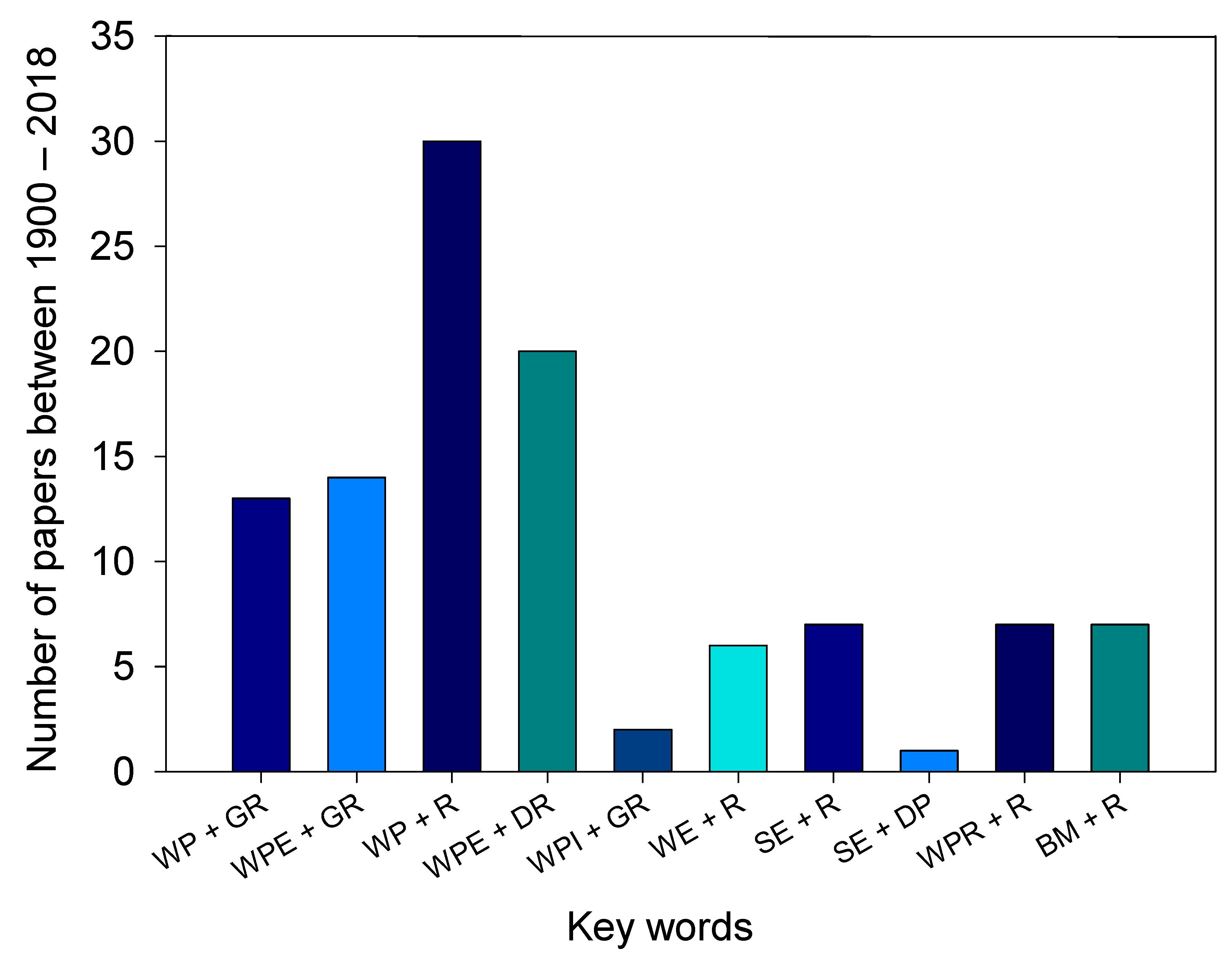
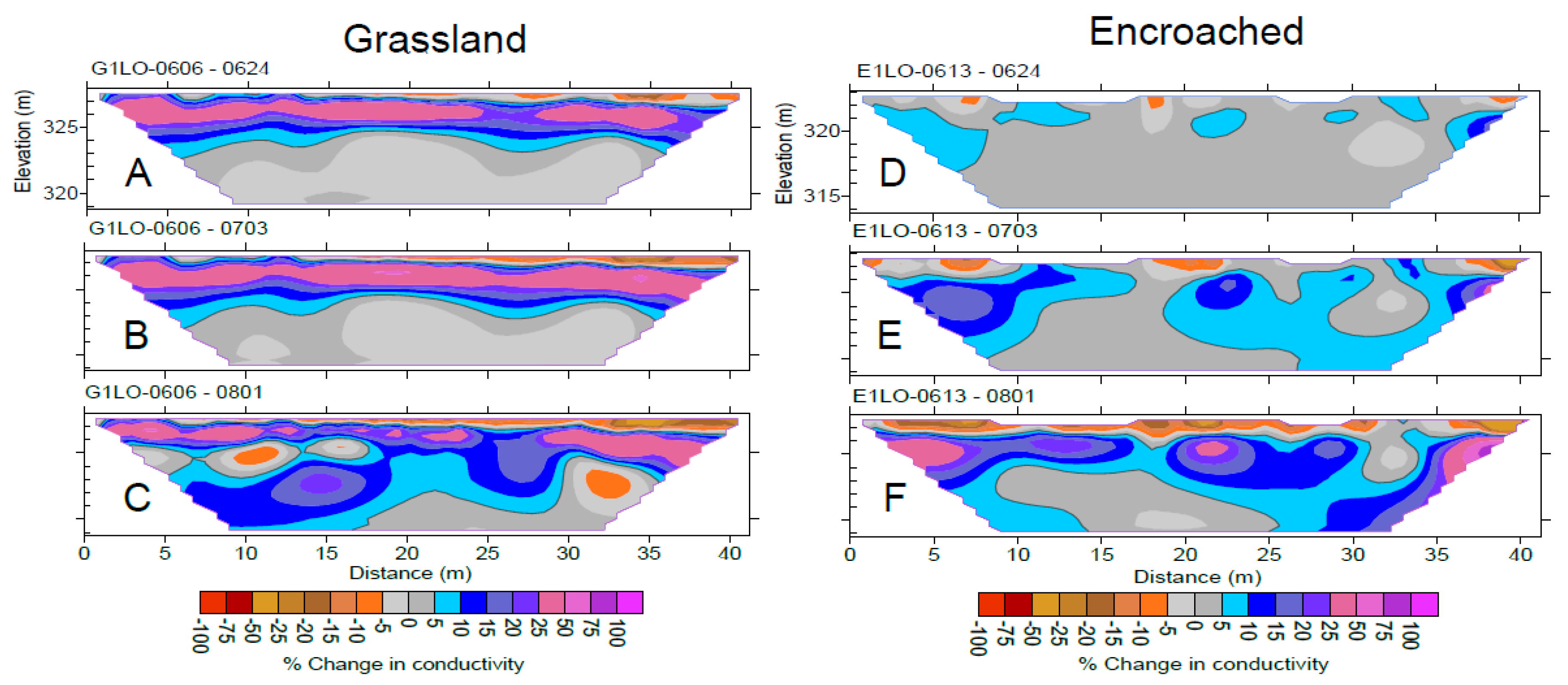
2.6. Geophysical Imaging

Geophysical methods are increasingly used to understand catchment hydrology and evaluate vegetation impacts on groundwater recharge [30,86,87,88]. Some geophysical methods include electrical resistivity imaging, electromagnetic induction, ground penetrating radar, and vertical electrical soundings. Electrical resistivity imaging (ERI) is a widely used geophysical technique in which surface electrodes are used for the acquisition of apparent resistivity data [89,90,91,92]. Such resistivity data is collected from the same location at different time intervals [93], and when no subsurface chemical reactions exist, any change in resistivity generally indicates a change in water content [86,94]. Resistivity 𝜌α (Ω-m) refers to the ratio between measured potential difference (∆V) and induced electric current (I) into the ground. Soil electrical conductivity σ (S m−1) is defined as the reciprocal of resistivity.
Subsurface electrical resistivity is affected by different factors such as solid constituents (grain size and distribution), soil moisture, porosity (void distribution and form), soil cavities and fractures, the degree of water saturation, concentration of dissolved salts, and soil temperature [92]. There is a strong correlation between electrical resistivity and volumetric soil moisture content. With increasing water content, the electrical conduction increases and resistivity decreases. Details on principles, methods, and application of electrical resistivity survey are available from earlier reviews [86,92,94].
Electrical resistivity imaging has been applied to grassland, forest, and woodland biomes to monitor spatiotemporal changes in soil moisture and sap flow. Acharya et al. [30] used temporal electrical resistivity imaging to monitor deep water content in four contrasting vegetation types (tallgrass prairie, prairie heavily encroached by juniper, juniper woodland, and oak forest) in the South-Central Great Plains, USA. Results showed increased spatial-temporal variability in root zone conductivity under juniper-encroached catchment compared with grassland catchment, and two-layered moisture migration profiles under these two catchments (Figure 2). Recently, ERI was used to understand soil and xylem moisture content in ponderosa pine trees [95]. Overall, geophysical methods can be used to characterize subsurface anisotropy, understand groundwater flow, and evaluate groundwater recharge. These data can be integrated with point hydrogeological data to provide a detailed view of subsurface flow conditions.
After examining the different methods used to estimate recharge, we see that the choice of the method varies with factors related to climate and scales of time and space [39]. For example, saturated zone techniques are more common in humid regions, while unsaturated zone techniques are commonly practiced in arid and semiarid regions [39]. Our review also indicates that isotopic and electrical geophysical methods are increasingly being used to investigate the impact woody plants encroachment on soil and groundwater. Point measurements fail to provide adequate information on inter-relationships between vegetation and subsurface properties and processes. In the future, isotopic and electrical methods could improve our understanding of the interconnections and feedbacks associated with soil moisture, plant water usage, subsurface properties, and water storage and migration. While each method is associated with different degrees of uncertainty, a combination of different methods could complement each other [31].

3. Mechanisms by Which Woody Plant Encroachment Affects Deep Drainage and Recharge

With woody encroachment, the vertical movement of water in deep soil matrix is interfered by the change in rooting pattern or depth, which results from the change in plant functional type. An improved understanding of vegetation impact on ecohydrological properties and water balance components is necessary to ensure sustainable ecosystem functions and services and to develop land-based mitigation and adaptation strategies under global environmental change. For example, understanding the impact of woody plant encroachment on streamflow and groundwater recharge is essential to proper land management to promote increased water yield in water-limited ecosystems [46,103,104].

3.1. Water Use and Evapotranspiration

Woody plant encroachment affects individual component of water balance differently and the effect varies with climate, vegetation, and edaphic factors [9,105]. A substantial shift from T to more ET is likely to occur in semiarid and subhumid regions as the ratio of bare ground to vegetated ground decreases with encroachment [9]. An Oklahoma study looking at the effect of vegetation on evapotranspiration in tallgrass prairie, compared the one-year ET of a denuded tall grass prairie plot with an undisturbed prairie plot and found that ET was lower in the non-vegetated site (547 mm year−1) compared to 728 mm year−1 in the actively growing prairie [106]. In the South-Central USA with arid and subhumid climate, ET is mostly confined by the amount of soil moisture available for latent heat to transform liquid water into water vapor. There is a tight coupling of vegetation and water fluxes, and the conversion of herbaceous vegetation to woody life forms is associated with a substantial increase in ET [9,107]. In Western USA, Scott et al. [108] reported a higher mean annual ET of 449 mm year−1 under mesquite woodland, compared with 279 mm year−1 under shrubland and 259 mm year−1 under grassland in gravelly sandy loam soil of Arizona, USA.
Drier climates may show the non-linear response of ET to increase in woody plant cover in part due to the nonlinear relationship between rainfall amount and canopy interception loss [109], but also because trees are deep-rooted and can access deep water. This response was explained by Walter in 1939. He purposed a two-layer hypothesis for tree-grass niche separation in dry savannas, which assumed that trees could access water from deeper layers, whereas grasses access water from topsoil [110]. Woody plants have higher air turbulence in the canopy boundary layer, which could increase potential ET. Additionally, many woody plants, such as the Eastern redcedar, are evergreen and consume water throughout the year. Assuming no change in soil water storage for a given water year, an increase in ET translates into a reduced potential for groundwater recharge. Overall, the literature reviewed herein suggests that ET increase and groundwater recharge decrease with woody plant encroachment.

3.2. Infiltration

Change in plant functional type, due to woody encroachment, alters transpiration and interception [32,109] and soil physical properties such as organic matter and soil aggregates, which in turn leads to changes in soil infiltration rate, soil water storage [104], and subsurface flow pathways [111]; all of which affect streamflow and groundwater recharge [70,103]. Eldridge et al. [112] measured lower steady state infiltration and sorptivity under shrubland compared to grassland and observed that shrub interspaces, not the increase in total shrub cover, were the major driver of lower infiltration following encroachment. The infiltration rates under shrubs (e.g., 48.2 mm h−1) were greater than at the interspaces (e.g., 17.0 mm h−1). Wine et al. [113] observed lower sorptivity and hydraulic conductivity under juniper trees compared with grasses under dry condition. Recorded low infiltration rates are usually associated with increasing cattle trampling and compaction for the interspace and development of hydrophobic litter and soil. However, infiltration capacity may be greatly enhanced once the woody canopy is closed and cattle grazing is reduced or excluded. Magliano et al. [114] observed higher infiltration rate (139.9 vs. 71.6 mm h−1) under woodlands compared to pastures in dry Chaco rangelands, Argentina. Zou et al. [104] observed three-fold higher steady state infiltration rates under juniper canopy compared to grassland. Such effects may occur due to “island of fertility”, extensive root distribution, root activities, earthworm diversity, and macropores beneath the canopy. Increase in soil infiltration capacity assists conservation of water in the ecosystem by reducing overland flow from high-intensity storm events and may improve soil moisture recharge to deep soil layer. Qiao et al. [111] reported that, compared to grasses, woody plants reduced surface flow and subsurface flow and shifted runoff from saturation excess overland flow to infiltration excess overland flow. Overall, the impacts of woody plants on infiltration are mixed. However, increased infiltration in the soils underneath the canopy and around the canopy coverage area is likely. Yet, it remains fundamentally unexplored how climate, vegetation types, vegetation canopy cover, and grazing regime interact to affect soil infiltration capacity.

3.3. Plant Traits

Strong coupling between groundwater, vegetation, and atmospheric processes has long been recognized in the semiarid and sub-humid ecosystems where woodland encroachment has been wildly reported [9,115]. Plants and their traits, such as leaf area, rooting structure, and phenology, determine the degree of precipitation loss to canopy interception and the depth and seasonality of root water uptake [10]. A major effect of woody plant encroachment is to change the albedo and therefore the partitioning of energy input in grassland. Grasslands usually have a low canopy surface roughness and consequently high albedo. In contrast, encroaching and infilling of shrubs and trees into the prairie is characterized by a mosaic structure, and tends to generate higher surface roughness. Encroaching trees produce a shading effect both on adjacent trees and grasses, and this shading effect is thought to be an important controlling factor of energy dynamics in these systems. Additionally, plant phenology will likely play a proactive role in energy and soil moisture dynamics among different vegetation types. For example, drier soils were reported under juniper in Nebraska due to a more extended growing season and higher interception compared to grasslands [116]. Further, access and extraction of groundwater are enhanced by woody encroachments. The deeper and more extensive rooting architecture of woody plants allows them to have a more robust water uptake strategy to explore both shallow and deeper soil moisture sources to meet the atmospheric demand [56]. Woody encroachments also form preferential flow paths via continuous root channels and enhanced organic matter and biological activity [117], thus increasing downward water fluxes. While more emphasis has been placed on woody plant encroachment into grassland or savanna type vegetation, woody understory encroachment into woodlands or forests can alter the physiological state of the trees and modify overstory functioning [13], and therefore groundwater recharge.

3.3.1. Canopy and Litter Interception

Canopy and litter interception affect local recharge of groundwater by modifying the net precipitation and thus the net water input to the soil. Studies on interception loss to woody plants include [32,109,118,119,120,121], among others. One such study found that woody plants have higher canopy storage capacity for rainfall compared to grassland [109]. Under the hot and dry climate in the South-Central Great Plains, over 35% of the bulk rainfall can be intercepted by the closed canopy of junipers on an annual basis [71,119]. However, 5–10% of bulk rainfall may be redistributed to the base of the juniper trees from stemflow and thus contributes to net water input [107,118].
The litter layer plays an interactive role in water flux at the soil and atmosphere boundary. A thick layer of litter will intercept a part of throughfall as a net loss to precipitation input. However, the litter layer also serves as a cover on soil, slowing or preventing soil evaporation [122] and this effect can be significant in an ecosystem with substantial bare soil and intercanopy patches [122]. The limited number of studies on litter interception makes drawing conclusions difficult. Therefore the quantitative role that litter plays in the water budget and soil moisture replenishment in many ecosystems remains largely unknown. Further work and development of practical and reliable approaches to quantify the water absorption and release in litter under field conditions will help in our understanding and estimation of litter interception [32].

3.3.2. Soil Water Repellency

Soil water repellency, also referred to as hydrophobicity, is caused by non-polar coatings of hydrophobic organic compounds on soil and by hydrophobic particulate organic matter [123]. While water repellency was reported back in 1917, studies were limited, and research gained momentum only after the 1970’s. Two approaches commonly used now to test repellency include water drop penetration time and molarity of ethanol droplet. The occurrence of repellency is largely associated with litter layer, secretion of hydrophobic compounds by plants, organic matter and humus, fungal hyphae, and microbial activities [123]. Soil water repellency affects local recharge by re-routing the flow paths. Robinson et al. [124] observed soil water repellency under pinyon and juniper due largely to litter layer and fungal mats. This repellency occurred to depths of 20 cm under juniper trees and concentrated water underneath the canopy due to the presence of bypass flow. Wine et al. [113] also observed higher soil water repellency under the Eastern redcedar than under grasses. Soil water repellency may reduce deep percolation and local recharge due to a decrease in infiltration rates [125]. Conversely, increased repellency can enhance the transport of water into deeper profiles due to the creation of uneven wetting fonts and preferential flow paths [123]. Increased repellency can also prevent litter interception and therefore increase surface evaporation [124]. Overall, studies indicate the mixed effect of soil water repellency on groundwater recharge.

4. Recharge as Affected by Geology and Substrate

4.1. Sandstone Bedrock

The substrate plays essential roles in routing percolated water. Sandstone bedrock, with a typical porosity ranging from 5 to 30% and effective porosity from 0.5 to 10%, is generally permeable and may act as a reservoir to hold deep percolated water in place or turn that water into lateral flow or interflow [30,31]. Vertical and lateral propagation of soil moisture with the same sandstone bedrock differs between grasslands and sites heavily encroached by the Eastern redcedar [30]. In grasslands, a high electrical conductivity layer forms after extended precipitation and water migrates laterally at soil bedrock interfaces, even though the sandstone is permeable (Figure 2). In contrast, the high electrical conductivity layer rarely forms along the soil-bedrock interfaces under woody plant encroachment. Woody plants attenuate the precipitation pulse in the rooting zone and slow or prevent soil water from leaking out of the rooting zone [107]. Additionally, woody plants are capable of accessing and extracting water held in sandstone bedrock as the soil dries out [126]. Therefore, the difference in plant functional types interacts with substrates to alter the subsurface flow and recharge potential. This difference may not prevail if the soil is shallow, dry and the soil moisture and root system interaction are reduced, such as in karst ecosystems [127].

4.2. Karst Ecosystems

Karst landscapes are highly fractured and often contain caves, sinkholes, and shallow, rocky soils. Recharge in karst ecosystems often occurs via conduit flow. For example, two geological formations are apparent in the Edwards Plateau: The Edwards formation (higher elevation, consists of thin, rocky soil underlain by fractured limestone bedrock) and the Glen Rose formation (lower elevation, consists of 0.1–1 m deep soil underlain by marl or dolostone) [128]. Marl is relatively permeable with higher water holding capacity whereas the dolostones are hard and less permeable. Karst ecosystems are unique because cracks and fissures allow the preferential flow of water, while highly weathered marls in rock layers could retain substantial water.
Trees can access deep water through deeper roots and affect ecosystem function and services. This has long been observed in the drylands of Southwestern North America. While such processes generally hold true, woody plants, however, show very limited access to deep water in karst ecosystems [129]. As discussed before, impacts of woody plants on hydrological processes can vary with climate, land use and land cover, and edaphic factors [9,105]. Wilcox et al. [127] reported that change in shrub cover had little to no effect on streamflow in semi-arid karst rangelands and that recharge in that setting depends on discrete fractures. Moreover, the groundwater bodies are poorly connected in Karst region [127]. Ochoa et al. [96] studied the effects of juniper woodlands in a semiarid rangeland in moderately shallow to deep soils, with fractured rock substrates. They observed that lower topographic relief and subsurface geology increased transient water storage and water release through shallow aquifers. Groundwater wells over fractured rock in their study site showed rapid rise and decline in groundwater levels with woody plant removal. Three major conclusions can be drawn from earlier studies: (i) Woody plant removal may increase baseflow or recharge in areas where springs were present or from areas where trees may access deep water; (ii) in karst systems, plants reduce recharge by reducing epikarst (subcutaneous zone between soil and bedrock) water storage, not by tapping into perched water tables [128]; and (iii) land degradation, not woody plant encroachment, reduces recharge in Edwards Plateau region of Texas [130].

5. Recharge as Affected by Soil Texture and Depth

The impact of woody plants on deep drainage and recharge across different locations, climate, and soil are summarized in Table 3. Soil texture and soil depth affect pore size distribution in soil, water-holding capacity, and water available for transpiration, all of which affect groundwater recharge. Fine textured (clayey) soils have higher water holding capacity than coarse-textured (sandy) soils due to more pore space. Clayey soils have more micropores and thus higher plant available water than coarse-textured soil. However, water may move slowly through clayey soils due to small grain size and greater surface area, which renders lower specific yield and drainage. Indeed, coarse-textured soils with higher hydraulic conductivity have higher groundwater recharge, whereas fine-textured soils may have negligible recharge [51]. Kennett-Smith et al. [131] reported that groundwater recharge decreases as clay content increases from 0 to 25% in the top 2 m soil profile. Increasing depth of layers with low permeability will reduce the downward flux of water. Kim and Jackson [66] reported 50% more recharge in sandy soils compared to clayey soils.
Cracking clay soils have significant water holding capacity. In 1979, Richardson and coworkers studied the effect of brush control on Houston clay soil in Blackland Prairie [132]. These soils are defined as fine montmorillonitic cracking clays. Specifically, they retain water during dry spells, but swell when wet, leading to relatively low infiltration rates when soils are under wet conditions. Honey mesquite was observed to extract water from a deeper depth (120–150 cm) compared with prairie grasses, and brush control of the mesquite increased runoff by 10%. While recharge was not estimated in their study, after the brush removal, rainwater recharged soil moisture down to 150 cm and this water eventually drained to deeper soils.
Shallow soils have roots of grasses and woody plants occupying the entire soil profile, which causes the soil to dry out rapidly. Consequently, there may not be a measurable difference in plant water use among plant functional types. In deep soils, woody plants can, however, access deep water that is beyond the reach of shallow roots (https://ok.gov/conservation/documents/). Deep clay or silty soils may have very limited potential for recharge [54,133]. Schwinning [128] showed that recharge in deep soil is largely affected by the plant’s ability to use shallow water. Deep soils provide higher buffering capacity for trees against rainfall variations, but in shallow soils, such climatic variations could concurrently affect both herbaceous and woody plants [128]. In relatively deep soil such as in the South-Central Great Plains, soil depth under different plant functional types affect variations in soil moisture periodicities, with variation decreasing with increasing soil depth. High frequency periodicities in shallow soil occur less often under woody plant encroachment compared to grassland [107]. Consequently, the impact of woody plants on groundwater recharge varies with soil type, texture, and depth [52,68,128,132,134].
These findings suggest that soil texture and depth variably affect hydraulic conductivity, plant water extraction, and groundwater recharge. An improved understanding of their interactive effects on groundwater recharge is critical in forming and assessing land management strategies to curtail the proliferation of woody plant encroachment.

6. Does Woody Plant Removal Increase Groundwater Recharge?

Encroaching woody plants increase transpiration and interception rates leading to loss of available water in the system [137]. For example, Saleh et al. [138] reported that brush control might reduce ET by up to 25%. Two important determinants of groundwater recharge as a response to woody plant removal include shallow effective rooting depth and plant-available water. Seyfried and Wilcox [139] reported that the effective rooting depth decreased from 200 to 140 cm post-fire treatment in semiarid rangelands of Southwest Idaho, which increased the deep drainage of water by six cm [139].
Table 3 shows that woody plant removal could have a mixed effect on groundwater recharge. For example, in Verde Valley area, Arizona, Wyatt et al. [140] observed a 2.8% increase in recharge when basal area reduction was used as a forest restoration treatment, but such effects decreased with regrowth of underbrush and a subsequent increase in ET. In the Carrizo–Wilcox aquifer area of Texas, woody plant removal increased deep moisture and therefore recharge by a modest amount [68]. The effect of woody plant removal may vary with species and site. For example, the removal of juniper is likely to increase recharge in areas with deep soil and subsurface flow paths [103]. Contrastingly, woody plant removal has a very little effect on recharge occurring via conduit flow in the Edwards Plateau region, Texas [100]. Ilstedt et al. [101] proposed and tested an optimum plant cover theory in seasonally dry tropics, and reported that recharge increases with intermediate plant cover. Consequently, the effect of woody plant removal on groundwater recharge depends on the (i) amount of rainfall; (ii) woody plant cover; (iii) permeable or hardy parent material; and (iv) interception characteristics [103]. More studies are needed to fully evaluate the effects of woody plant encroachment and brush management on groundwater recharge.

7. Climate Change, Woody Encroachment, and Groundwater Recharge

Anthropogenic emission of greenhouse gases and land use changes has caused the surface temperature to rise, with significant effects on natural, managed and human systems. Global mean surface temperature has increased by 1.0 °C since the 1850’s, and is projected to reach 1.5 °C between 2030 and 2052 [141]. Atmospheric CO2 concentration has increased from pre-industrial levels of 280 ppm to 405 ppm and is projected to exceed 600 ppm by the end of this century. Climate change is likely to increase warm temperature extremes, frequency, intensity, and amount of rainfall, and the occurrence of extreme events like floods and droughts. Alterations in rainfall and temperature are likely to affect available water, flow regimes, and hydrologic budgets. Additionally, they could modify woody biomass, fire, herbivory, and vegetation structure and functions, all of which affect groundwater recharge.
Effects of climate change are highly uncertain, and plant response to climate change may vary with sites, vegetation, disturbance regime, and management. While total rainfall may decrease, rainfall intensity is expected to increase in drylands [142]. Reduced rainfall in general decreases groundwater recharge. Deeper infiltration may occur under intense storms; thereby increasing water availability for woody plants [142]. Climate-induced droughts could increase tree die-off via xylem cavitation, carbon starvation, and hydraulic failure [143,144]. Additionally, temperature shifts may trigger biotic stress (e.g., bark beetles), and alter ecosystem productivity and water budgets [145].
An elevated CO2 may benefit plants with C3 photosynthetic pathways (e.g., eastern redcedar); however, effects are likely to be constrained by resources availability, stresses, and ecological interactions [24,146]. To cite an example, the rise in CO2 levels may increase water use efficiency, extend a plants growing season and shift vegetation physiognomy from herbaceous to woody dominance, with potential ramifications on recharge. The CO2 enrichment hypothesis and woody plants encroachment have been discussed in several studies [1,24]. Plant response to climate change will vary with alteration in water availability and changing water allocation [147]. Indeed, with changing climate, a comprehensive understanding of the interrelationships between groundwater, surface water, vegetation and climate at multiple scales is necessary to manage water resources and to adapt to climatic changes.

8. Summary and the Way Forward in Woody Plant Encroachment Impact on Groundwater Recharge

Groundwater depletion is a global issue. High rates of groundwater withdrawal are likely to affect natural and managed ecosystems and alter climatic feedback and stream-flow response to rainfall [44,54,148]. Biome-level shifts from grassland to woodland have important ecohydrological repercussions. As such, understanding the impact of vegetation and vegetation transition is pivotal to manage land cover for water supply. This review indicates that groundwater recharge is sensitive to vegetation transition and the impacts of woody plant encroachment on water budget are complex and still under-studied. Isotopes and geophysical methods were identified as powerful tools to understand deep drainage and recharge. Hydrological impact of woody plant encroachment is different between sandstone bedrocks and karst regions, and between deep soils and shallow soils. Experimental studies indicated a mixed effect of woody plant removal on groundwater recharge. However, positive effects are likely in deep soil and areas dominated by subsurface flow paths. A few areas that deserve close attention include:
  • It is important to quantify recharge under different woody plant species and environment at spatial and temporal scales.
  • Litter interception of rainfall under woody plant encroachment is poorly studied. While litter interception affects deep drainage and groundwater recharge, only a few studies have quantified the interception storage capacity and interception loss.
  • Root depth, size, shape, spread, and water uptake have not been extensively researched within the context of woody encroachment. Information on woody root systems is important to predict ecosystem functions (e.g., hydraulic lift, drainage, and water balance) and biosphere-atmosphere interactions [149]. Use of stable isotopes can provide valuable information on rooting depths, plant water uptake, and the hydrologic linkage of transpiration and groundwater and/or surface and groundwater, among others.
  • Very few studies have tested the effect of woody plant removal on groundwater recharge. Effects of brush control/woody plant removal vary with site and plant characteristics, and therefore removal should be focused in areas where positive effects are likely. Recently, the “alternative stable state theory” and “pyric herbivory” theories have been discussed to understand the mechanisms of such woody plant encroachment and to inform management solutions [22]. An alternative stable state theory largely predicts ecosystem state transitions in savannas based on resilience and adaptability, whereas pyric herbivore theory emphasizes fire and grazing interactions to manage and restore grassland biomes. The effects of woody plant control on bypass flow, regional scale water quality and quantity, and regional climate also needs to be studied [135].
  • Vegetation mapping is envisioned as a proxy for groundwater recharge [10]; yet broader understanding and development of interrelationships between vegetation, hydraulic factors, and recharge continues to be an enigma.
  • We reviewed major techniques to estimate recharge based on unsaturated and saturated zone data. While different methods can be used to complement recharge estimates, it is highly important to identify a cost-effective approach.
  • Global climate change is likely to alter rainfall and temperature regimes, increase frequency and intensity of extreme events, and shift plant functional types, which could modify interception, infiltration, evapotranspiration, subsurface flow, groundwater recharge, and climatic feedbacks. The effects of climate change are largely uncertain and further research is warranted.
Overall, woody plant encroachment is likely to alter groundwater recharge, and impacts vary in magnitude with time and space. Having a thorough understanding and documentation of the impacts of woody plant encroachment in different settings of climate, vegetation, soil, geological formation, and time periods can help in the sustainable management of water resources in water-limited regions.

Author Contributions

C.B.Z., B.P.W. and B.S.A. conceived the idea; B.S.A., G.K. conducted the literature review; all authors contributed to the writing of the paper.

Funding

This work was partially supported by the National Science Foundation under grant DEB-1413900 and grant OIA-1301789.

Acknowledgments

Authors would like to gratefully acknowledge Elaine Stebler for reviewing earlier version of this paper and technical editing of the final version.

Conflicts of Interest

The authors declare no competing interests.

References

  1. Van Auken, O. Causes and consequences of woody plant encroachment into western north American grasslands. J. Environ. Manag. 2009, 90, 2931–2942. [Google Scholar] [CrossRef] [PubMed]
  2. Van Auken, O.W. Shrub invasions of north American semiarid grasslands. Annu. Rev. Ecol. Syst. 2000, 31, 197–215. [Google Scholar] [CrossRef]
  3. Ayers, D.; Melville, G.; Bean, J.; Beckers, D.; Ellis, M.; Mazzer, T.; Freudenberger, D. Woody Weeds, Biodiversity and Landscape Function in Western New South Wales; WEST 2000: Dubbo, Australia, 2001; ISBN 0731363620. [Google Scholar]
  4. Noble, J.C. The Delicate and Noxious Scrub: Csiro Studies on Native Tree and Shrubproliferation in the Semi-Arid Woodlands of Eastern Australia; Csiro Publishing: Clayton, Australia, 1997. [Google Scholar]
  5. Maestre, F.T.; Bowker, M.A.; Puche, M.D.; Belén Hinojosa, M.; Martínez, I.; García-Palacios, P.; Castillo, A.P.; Soliveres, S.; Luzuriaga, A.L.; Sánchez, A.M.; et al. Shrub encroachment can reverse desertification in semi-arid Mediterranean grasslands. Ecol. Lett. 2009, 12, 930–941. [Google Scholar] [CrossRef] [PubMed]
  6. Archer, S.; Boutton, T.W.; Hibbard, K.A. Trees in grasslands: Biogeochemical consequences of woody plant expansion. In Global Biogeochemical Cycles in the Climate System; Schulze, M., Heimann, S., Harrison, E., Holland, J., Lloyd, I., Prentice, C., Schimel, D., Eds.; Elsevier: Amsterdam, The Netherlands, 2001; pp. 115–137. [Google Scholar]
  7. Moleele, N.; Ringrose, S.; Vanderpost, C.; Matheson, W. More woody plants? The status of bush encroachment in botswana’s grazing areas. J. Environ. Manag. 2002, 64, 3–11. [Google Scholar] [CrossRef]
  8. Engle, D.M.; Coppedge, B.R.; Fuhlendorf, S.D. From the dust bowl to the green glacier: Human activity and environmental change in great plains grasslands. In Western North American Juniperus Communities; Springer: Berlin, Germany, 2008; pp. 253–271. [Google Scholar]
  9. Huxman, T.E.; Wilcox, B.P.; Breshears, D.D.; Scott, R.L.; Snyder, K.A.; Small, E.E.; Hultine, K.; Pockman, W.T.; Jackson, R.B. Ecohydrological implications of woody plant encroachment. Ecology 2005, 86, 308–319. [Google Scholar] [CrossRef]
  10. Newman, B.D.; Wilcox, B.P.; Archer, S.R.; Breshears, D.D.; Dahm, C.N.; Duffy, C.J.; McDowell, N.G.; Phillips, F.M.; Scanlon, B.R.; Vivoni, E.R. Ecohydrology of water-limited environments: A scientific vision. Water Resour. Res. 2006, 42. [Google Scholar] [CrossRef] [Green Version]
  11. Wainwright, J.; Parsons, A.J.; Abrahams, A.D. Plot-scale studies of vegetation, overland flow and erosion interactions: Case studies from Arizona and New Mexico. Hydrol. Process. 2000, 14, 2921–2943. [Google Scholar] [CrossRef]
  12. Guido, A.; Salengue, E.; Dresseno, A. Effect of shrub encroachment on vegetation communities in Brazilian forest-grassland mosaics. Perspect. Ecol. Conserv. 2017, 15, 52–55. [Google Scholar] [CrossRef]
  13. Rolo, V.; Moreno, G. Shrub species affect distinctively the functioning of scattered quercus ilex trees in Mediterranean open woodlands. For. Ecol. Manag. 2011, 261, 1750–1759. [Google Scholar] [CrossRef]
  14. Lunt, I.D.; Winsemius, L.M.; McDonald, S.P.; Morgan, J.W.; Dehaan, R.L. How widespread is woody plant encroachment in temperate Australia? Changes in woody vegetation cover in lowland woodland and coastal ecosystems in Victoria from 1989 to 2005. J. Biogeogr. 2010, 37, 722–732. [Google Scholar] [CrossRef] [Green Version]
  15. Hu, X.; Li, Z.-C.; Li, X.-Y.; Liu, Y. Influence of shrub encroachment on ct-measured soil macropore characteristics in the inner Mongolia grassland of northern China. Soil Tillage Res. 2015, 150, 1–9. [Google Scholar] [CrossRef]
  16. Venter, Z.; Cramer, M.; Hawkins, H.-J. Drivers of woody plant encroachment over Africa. Nat. Commun. 2018, 9, 2272. [Google Scholar] [CrossRef] [PubMed] [Green Version]
  17. Wine, M.L.; Zou, C.B. Long-term streamflow relations with riparian gallery forest expansion into tallgrass prairie in the southern great plains, USA. For. Ecol. Manag. 2012, 266, 170–179. [Google Scholar] [CrossRef]
  18. Barger, N.N.; Archer, S.R.; Campbell, J.L.; Huang, C.Y.; Morton, J.A.; Knapp, A.K. Woody plant proliferation in north American drylands: A synthesis of impacts on ecosystem carbon balance. J. Geophys. Res. Biogeosci. 2011, 116. [Google Scholar] [CrossRef]
  19. Stevens, N.; Lehmann, C.E.; Murphy, B.P.; Durigan, G. Savanna woody encroachment is widespread across three continents. Glob. Chang. Biol. 2017, 23, 235–244. [Google Scholar] [CrossRef] [PubMed]
  20. Knapp, A.K.; Briggs, J.M.; Collins, S.L.; Archer, S.R.; Bret-Harte, M.S.; Ewers, B.E.; Peters, D.P.; Young, D.R.; Shaver, G.R.; Pendall, E. Shrub encroachment in north American grasslands: Shifts in growth form dominance rapidly alters control of ecosystem carbon inputs. Glob. Chang. Biol. 2008, 14, 615–623. [Google Scholar] [CrossRef]
  21. Pacala, S.W.; Hurtt, G.C.; Baker, D.; Peylin, P.; Houghton, R.A.; Birdsey, R.A.; Heath, L.; Sundquist, E.T.; Stallard, R.; Ciais, P. Consistent land-and atmosphere-based us carbon sink estimates. Science 2001, 292, 2316–2320. [Google Scholar] [CrossRef] [PubMed]
  22. Wilcox, B.P.; Birt, A.; Fuhlendorf, S.D.; Archer, S.R. Emerging frameworks for understanding and mitigating woody plant encroachment in grassy biomes. Curr. Opin. Environ. Sustain. 2018, 32, 46–52. [Google Scholar] [CrossRef]
  23. Wu, X.B.; Archer, S.R. Scale-dependent influence of topography-based hydrologic features on patterns of woody plant encroachment in savanna landscapes. Lands. Ecol. 2005, 20, 733–742. [Google Scholar] [CrossRef]
  24. Archer, S.; Schimel, D.S.; Holland, E.A. Mechanisms of shrubland expansion: Land use, climate or CO2? Clim. Chang. 1995, 29, 91–99. [Google Scholar] [CrossRef]
  25. Briggs, J.M.; Hoch, G.A.; Johnson, L.C. Assessing the rate, mechanisms, and consequences of the conversion of tallgrass prairie to Juniperus virginiana forest. Ecosystems 2002, 5, 578–586. [Google Scholar] [CrossRef]
  26. Briggs, J.M.; Knapp, A.K.; Brock, B.L. Expansion of woody plants in tallgrass prairie: A fifteen-year study of fire and fire-grazing interactions. Am. Midl. Nat. 2002, 147, 287–294. [Google Scholar] [CrossRef]
  27. Archer, S.R.; Andersen, E.M.; Predick, K.I.; Schwinning, S.; Steidl, R.J.; Woods, S.R. Woody plant encroachment: Causes and consequences. In Rangeland Systems; Briske, D.D., Ed.; Springer: Cham, Switzerland, 2017; pp. 25–84. [Google Scholar]
  28. Ramírez, J.A.; Díaz, M. The role of temporal shrub encroachment for the maintenance of Spanish holm oak quercus ilex dehesas. For. Ecol. Manag. 2008, 255, 1976–1983. [Google Scholar] [CrossRef]
  29. Price, J.N.; Morgan, J.W. Multi-decadal increases in shrub abundance in non-riverine red gum (eucalyptus camaldulensis) woodlands occur during a period of complex land-use history. Aust. J. Bot. 2009, 57, 163–170. [Google Scholar] [CrossRef]
  30. Acharya, B.S.; Halihan, T.; Zou, C.B.; Will, R.E. Vegetation controls on the spatio-temporal heterogeneity of deep moisture in the unsaturated zone: A hydrogeophysical evaluation. Sci. Rep. 2017, 7, 1499. [Google Scholar] [CrossRef] [PubMed]
  31. Acharya, B.S.; Hao, Y.; Ochsner, T.E.; Zou, C.B. Woody plant encroachment alters soil hydrological properties and reduces downward flux of water in tallgrass prairie. Plant Soil 2017, 414, 379–391. [Google Scholar] [CrossRef]
  32. Acharya, B.S.; Stebler, E.; Zou, C.B. Monitoring litter interception of rainfall using leaf wetness sensor under controlled and field conditions. Hydrol. Process. 2017, 31, 240–249. [Google Scholar] [CrossRef]
  33. Association, N.G. Facts about Global Groundwater Usage; National Groundwater Association: Westerville, OH, USA, 2016; p. 2. [Google Scholar]
  34. Siebert, S.; Burke, J.; Faures, J.-M.; Frenken, K.; Hoogeveen, J.; Döll, P.; Portmann, F.T. Groundwater use for irrigation–a global inventory. Hydrol. Earth Syst. Sci. 2010, 14, 1863–1880. [Google Scholar] [CrossRef] [Green Version]
  35. Gleeson, T.; Befus, K.M.; Jasechko, S.; Luijendijk, E.; Cardenas, M.B. The global volume and distribution of modern groundwater. Nat. Geosci. 2016, 9, 161. [Google Scholar] [CrossRef]
  36. Foley, J.A.; Ramankutty, N.; Brauman, K.A.; Cassidy, E.S.; Gerber, J.S.; Johnston, M.; Mueller, N.D.; O’Connell, C.; Ray, D.K.; West, P.C.; et al. Solutions for a cultivated planet. Nature 2011, 478, 337–342. [Google Scholar] [CrossRef] [PubMed] [Green Version]
  37. Wada, Y.; van Beek, L.P.; van Kempen, C.M.; Reckman, J.W.; Vasak, S.; Bierkens, M.F. Global depletion of groundwater resources. Geophys. Res. Lett. 2010, 37. [Google Scholar] [CrossRef] [Green Version]
  38. Konikow, L.F.; Kendy, E. Groundwater depletion: A global problem. Hydrogeol. J. 2005, 13, 317–320. [Google Scholar] [CrossRef]
  39. Scanlon, B.R.; Healy, R.W.; Cook, P.G. Choosing appropriate techniques for quantifying groundwater recharge. Hydrogeol. J. 2002, 10, 18–39. [Google Scholar] [CrossRef]
  40. Sophocleous, M. Groundwater recharge. In Encyclopedia of Life Support Systems (EOLSS); Silveira, L.S.W., Ed.; Unesco Eolss: Oxford, UK, 2004. [Google Scholar]
  41. Villegas, J.C.; Dominguez, F.; Barron-Gafford, G.A.; Adams, H.D.; Guardiola-Claramonte, M.; Sommer, E.D.; Selvey, A.W.; Espeleta, J.F.; Zou, C.B.; Breshears, D.D.; et al. Sensitivity of regional evapotranspiration partitioning to variation in woody plant cover: Insights from experimental dryland tree mosaics. Glob. Ecol. Biogeogr. 2015, 24, 1040–1048. [Google Scholar] [CrossRef]
  42. Ge, J.; Zou, C. Impacts of woody plant encroachment on regional climate in the southern great plains of the United States. J. Geophys. Res. Atmos. 2013, 118, 9093–9104. [Google Scholar] [CrossRef]
  43. Jasechko, S.; Birks, S.J.; Gleeson, T.; Wada, Y.; Fawcett, P.J.; Sharp, Z.D.; McDonnell, J.J.; Welker, J.M. The pronounced seasonality of global groundwater recharge. Water Resour. Res. 2014, 50, 8845–8867. [Google Scholar] [CrossRef] [Green Version]
  44. Scanlon, B.R.; Keese, K.E.; Flint, A.L.; Flint, L.E.; Gaye, C.B.; Edmunds, W.M.; Simmers, I. Global synthesis of groundwater recharge in semiarid and arid regions. Hydrol. Process. 2006, 20, 3335–3370. [Google Scholar] [CrossRef]
  45. Weltz, M.A.; Blackburn, W.H. Water budget for south Texas rangelands. J. Range Manag. 1995, 48, 45–52. [Google Scholar] [CrossRef]
  46. Wilcox, B.P.; Dowhower, S.L.; Teague, W.R.; Thurow, T.L. Long-term water balance in a semiarid shrubland. Rangel. Ecol. Manag. 2006, 59, 600–606. [Google Scholar] [CrossRef]
  47. Healy, R.W.; Cook, P.G. Using groundwater levels to estimate recharge. Hydrogeol. J. 2002, 10, 91–109. [Google Scholar] [CrossRef]
  48. Zhang, Y.-K.; Schilling, K. Effects of land cover on water table, soil moisture, evapotranspiration, and groundwater recharge: A field observation and analysis. J. Hydrol. 2006, 319, 328–338. [Google Scholar] [CrossRef]
  49. Oliveira, P.; Wendland, E.; Nearing, M.; Scott, R.; Rosolem, R.; Da Rocha, H. The water balance components of undisturbed tropical woodlands in the Brazilian Cerrado. Hydrol. Earth Syst. Sci. 2015, 19, 2899–2910. [Google Scholar] [CrossRef]
  50. Oliveira, P.T.S.; Leite, M.B.; Mattos, T.; Nearing, M.A.; Scott, R.L.; de Oliveira Xavier, R.; da Silva Matos, D.M.; Wendland, E. Groundwater recharge decrease with increased vegetation density in the Brazilian Cerrado. Ecohydrology 2017, 10, e1759. [Google Scholar] [CrossRef]
  51. Jobbágy, E.G.; Jackson, R.B. Groundwater use and salinization with grassland afforestation. Glob. Chang. Biol. 2004, 10, 1299–1312. [Google Scholar] [CrossRef]
  52. Wilcox, B.P.; Le Maitre, D.; Jobbagy, E.; Wang, L.; Breshears, D.D. Ecohydrology: Processes and implications for rangelands. In Rangeland Systems; Briske, D.D., Ed.; Springer: Cham, Switzerland, 2017; pp. 85–129. [Google Scholar]
  53. Walker, G.R.; Zhang, L.; Ellis, T.W.; Hatton, T.J.; Petheram, C. Estimating impacts of changed land use on recharge: Review of modelling and other approaches appropriate for management of dryland salinity. Hydrogeol. J. 2002, 10, 68–90. [Google Scholar] [CrossRef]
  54. Scanlon, B.R.; Reedy, R.C.; Stonestrom, D.A.; Prudic, D.E.; Dennehy, K.F. Impact of land use and land cover change on groundwater recharge and quality in the southwestern US. Glob. Chang. Biol. 2005, 11, 1577–1593. [Google Scholar] [CrossRef]
  55. Dudley, B.D.; Marttila, H.; Graham, S.L.; Evison, R.; Srinivasan, M. Water sources for woody shrubs on hillslopes: An investigation using isotopic and Sapflow methods. Ecohydrology 2018, 11, e1926. [Google Scholar] [CrossRef]
  56. Rossatto, D.; Silva, L.; Sternberg, L.; Franco, A. Do woody and herbaceous species compete for soil water across topographic gradients? Evidence for niche partitioning in a Neotropical Savanna. South Afr. J. Bot. 2014, 91, 14–18. [Google Scholar] [CrossRef]
  57. Barbeta, A.; Peñuelas, J. Relative contribution of groundwater to plant transpiration estimated with stable isotopes. Sci. Rep. 2017, 7, 10580. [Google Scholar] [CrossRef] [PubMed]
  58. Evaristo, J.; McDonnell, J.J. Prevalence and magnitude of groundwater use by vegetation: A global stable isotope meta-analysis. Sci. Rep. 2017, 7, 44110. [Google Scholar] [CrossRef] [PubMed]
  59. McDonnell, J.J. The two water worlds hypothesis: Ecohydrological separation of water between streams and trees? Wiley Interdiscip. Rev. Water 2014, 1, 323–329. [Google Scholar] [CrossRef]
  60. Glover, E.; Akiti, T.; Osae, S. Environmental stable isotope studies of groundwater in the Accra plains. Elixir Pollut. 2013, 55, 12813–12819. [Google Scholar]
  61. Midwood, A.; Boutton, T.; Archer, S.R.; Watts, S.E. Water use by woody plants on contrasting soils in a savanna parkland: Assessment with δ2h and δ18o. Plant Soil 1998, 205, 13–24. [Google Scholar] [CrossRef]
  62. Allison, G.; Gee, G.; Tyler, S. Vadose-zone techniques for estimating groundwater recharge in arid and semiarid regions. Soil Sci. Soc. Am. J. 1994, 58, 6–14. [Google Scholar] [CrossRef]
  63. Gaye, C.; Edmunds, W. Groundwater recharge estimation using chloride, stable isotopes and tritium profiles in the sands of northwestern Senegal. Environ. Geol. 1996, 27, 246–251. [Google Scholar] [CrossRef] [Green Version]
  64. Sibanda, T.; Nonner, J.C.; Uhlenbrook, S. Comparison of groundwater recharge estimation methods for the semi-arid Nyamandhlovu area, Zimbabwe. Hydrogeol. J. 2009, 17, 1427–1441. [Google Scholar] [CrossRef] [Green Version]
  65. Gee, G.; Zhang, Z.; Tyler, S.; Albright, W.; Singleton, M. Chloride-Mass-Balance for Predicting Increased Recharge after Land-Use Change; University of California: Berkeley, CA, USA, 2004. [Google Scholar]
  66. Kim, J.H.; Jackson, R.B. A global analysis of groundwater recharge for vegetation, climate, and soils. Vadose Zone J. 2012, 11. [Google Scholar] [CrossRef]
  67. Wine, M.L.; Hendrickx, J.M.; Cadol, D.; Zou, C.B.; Ochsner, T.E. Deep drainage sensitivity to climate, edaphic factors, and woody encroachment, Oklahoma, USA. Hydrol. Process. 2015, 29, 3779–3789. [Google Scholar] [CrossRef]
  68. Moore, G.W.; Barre, D.A.; Owens, M.K. Does shrub removal increase groundwater recharge in southwestern Texas semiarid rangelands? Rangel. Ecol. Manag. 2012, 65, 1–10. [Google Scholar] [CrossRef]
  69. Tyner, J.; Brown, G.; Vogel, J.; Garbrecht, J. Chloride mass balance to determine water fluxes beneath kcl-fertilized crops. Trans. ASAE 2000, 43, 1553–1559. [Google Scholar] [CrossRef]
  70. Qiao, L.; Zou, C.B.; Will, R.E.; Stebler, E. Calibration of swat model for woody plant encroachment using paired experimental watershed data. J. Hydrol. 2015, 523, 231–239. [Google Scholar] [CrossRef]
  71. Zou, C.B.; Qiao, L.; Wilcox, B.P. Woodland expansion in central Oklahoma will significantly reduce streamflows—A modelling analysis. Ecohydrology 2016, 9, 807–816. [Google Scholar] [CrossRef]
  72. Arnold, J.G.; Srinivasan, R.; Muttiah, R.S.; Williams, J.R. Large area hydrologic modeling and assessment part i: Model development 1. JAWRA J. Am. Water Resour. Assoc. 1998, 34, 73–89. [Google Scholar] [CrossRef]
  73. Gassman, P.W.; Reyes, M.R.; Green, C.H.; Arnold, J.G. The soil and water assessment tool: Historical development, applications, and future research directions. Trans. ASAE 2007, 50, 1211–1250. [Google Scholar] [CrossRef]
  74. Shope, C.; Maharjan, G.; Tenhunen, J.; Seo, B.; Kim, K.; Riley, J.; Arnhold, S.; Koellner, T.; Ok, Y.; Peiffer, S. An interdisciplinary swat ecohydrological model to define catchment-scale hydrologic partitioning. Hydrol. Earth Syst. Sci. 2013, 10, 7235–7290. [Google Scholar] [CrossRef]
  75. Scott, R.L.; Shuttleworth, W.J.; Keefer, T.O.; Warrick, A.W. Modeling multiyear observations of soil moisture recharge in the semiarid American southwest. Water Resour. Res. 2000, 36, 2233–2247. [Google Scholar] [CrossRef]
  76. Simunek, J.; Van Genuchten, M.T.; Sejna, M. The Hydrus-1d Software Package for Simulating the One-Dimensional Movement of Water, Heat, and Multiple Solutes in Variably-Saturated Media; Agricultural Research Service, United States Department of Agriculture: Riverside, CA, USA, 2005; pp. 1–240.
  77. Feddes, R.; Kowalik, P.; Zaradny, H. Simulation of Field Water Use and Crop Yield; Wiley: New York, NY, USA, 1978; p. 188. [Google Scholar]
  78. Van Genuchten, M.T. A Numerical Model for Water and Solute Movement in and Below the Root Zone; United States Department of Agriculture Agricultural Research Service U.S. Salinity Laboratory: Riverside, CA, USA, 1987.
  79. Christensen, L.; Tague, C.L.; Baron, J.S. Spatial patterns of simulated transpiration response to climate variability in a snow dominated mountain ecosystem. Hydrol. Process. 2008, 22, 3576–3588. [Google Scholar] [CrossRef]
  80. Mittman, T.; Band, L.E.; Hwang, T.; Smith, M.L. Distributed hydrologic modeling in the suburban landscape: Assessing parameter transferability from gauged reference catchments 1. J. Am. Water Resour. Assoc. 2012, 48, 546–557. [Google Scholar] [CrossRef]
  81. Tague, C.; McMichael, C.; Hope, A.; Choate, J.; Clark, R. Application of the rhessys model to a California semiarid shrubland watershed 1. JAWRA J. Am. Water Resour. Assoc. 2004, 40, 575–589. [Google Scholar] [CrossRef]
  82. Tague, C.; Peng, H. The sensitivity of forest water use to the timing of precipitation and snowmelt recharge in the California sierra: Implications for a warming climate. J. Geophys. Res. Biogeosci. 2013, 118, 875–887. [Google Scholar] [CrossRef]
  83. Tague, C.; Band, L. Rhessys: Regional hydro-ecologic simulation system—An object-oriented approach to spatially distributed modeling of carbon, water, and nutrient cycling. Earth Interact. 2004, 8, 1–42. [Google Scholar] [CrossRef]
  84. Zierl, B.; Bugmann, H.; Tague, C.L. Water and carbon fluxes of European ecosystems: An evaluation of the ecohydrological model rhessys. Hydrol. Process. 2007, 21, 3328–3339. [Google Scholar] [CrossRef]
  85. Tague, C.; Seaby, L.; Hope, A. Modeling the eco-hydrologic response of a Mediterranean type ecosystem to the combined impacts of projected climate change and altered fire frequencies. Clim. Chang. 2009, 93, 137–155. [Google Scholar] [CrossRef]
  86. Jayawickreme, D.H.; Jobbágy, E.G.; Jackson, R.B. Geophysical subsurface imaging for ecological applications. New Phytol. 2014, 201, 1170–1175. [Google Scholar] [CrossRef] [PubMed]
  87. Jayawickreme, D.H.; Santoni, C.S.; Kim, J.H.; Jobbágy, E.G.; Jackson, R.B. Changes in hydrology and salinity accompanying a century of agricultural conversion in Argentina. Ecol. Appl. 2011, 21, 2367–2379. [Google Scholar] [CrossRef] [PubMed] [Green Version]
  88. Niemeyer, R.J.; Heinse, R.; Link, T.E.; Seyfried, M.S.; Klos, P.Z.; Williams, C.J.; Nielson, T. Spatiotemporal soil and saprolite moisture dynamics across a semi-arid woody plant gradient. J. Hydrol. 2017, 544, 21–35. [Google Scholar] [CrossRef]
  89. Halihan, T.; Fenstemaker, T. Proprietary Electrical Resistivity Imaging Method; Oklahoma State University Office of Intellectual Property: Stillwater, OK, USA, 2004. [Google Scholar]
  90. Halihan, T.; Paxton, S.; Graham, I.; Fenstemaker, T.; Riley, M. Post-remediation evaluation of a Lnapl site using electrical resistivity imaging. J. Environ. Monit. 2005, 7, 283–287. [Google Scholar] [CrossRef] [PubMed]
  91. Ma, Y.; Van Dam, R.L.; Jayawickreme, D.H. Soil moisture variability in a temperate deciduous forest: Insights from electrical resistivity and throughfall data. Environ. Earth Sci. 2014, 72, 1367–1381. [Google Scholar] [CrossRef]
  92. Samouëlian, A.; Cousin, I.; Tabbagh, A.; Bruand, A.; Richard, G. Electrical resistivity survey in soil science: A review. Soil Tillage Res. 2005, 83, 173–193. [Google Scholar] [CrossRef] [Green Version]
  93. Jayawickreme, D.H.; Van Dam, R.L.; Hyndman, D.W. Hydrological consequences of land-cover change: Quantifying the influence of plants on soil moisture with time-lapse electrical resistivity. Geophysics 2010, 75, WA43–WA50. [Google Scholar] [CrossRef]
  94. Loke, M.; Chambers, J.; Rucker, D.; Kuras, O.; Wilkinson, P. Recent developments in the direct-current geoelectrical imaging method. J. Appl. Geophys. 2013, 95, 135–156. [Google Scholar] [CrossRef]
  95. Mares, R.; Barnard, H.R.; Mao, D.; Revil, A.; Singha, K. Examining diel patterns of soil and xylem moisture using electrical resistivity imaging. J. Hydrol. 2016, 536, 327–338. [Google Scholar] [CrossRef] [Green Version]
  96. Ochoa, C.G.; Caruso, P.; Ray, G.; Deboodt, T.; Jarvis, W.T.; Guldan, S.J. Ecohydrologic connections in semiarid watershed systems of central oregon USA. Water 2018, 10, 181. [Google Scholar] [CrossRef]
  97. Dzikiti, S.; Schachtschneider, K.; Naiken, V.; Gush, M.; Moses, G.; Le Maitre, D.C. Water relations and the effects of clearing invasive prosopis trees on groundwater in an arid environment in the northern cape, south africa. J. Arid Environ. 2013, 90, 103–113. [Google Scholar] [CrossRef]
  98. Dzikiti, S.; Ntshidi, Z.; Le Maitre, D.C.; Bugan, R.D.; Mazvimavi, D.; Schachtschneider, K.; Jovanovic, N.Z.; Pienaar, H.H. Assessing water use by prosopis invasions and vachellia karroo trees: Implications for groundwater recovery following alien plant removal in an arid catchment in south africa. For. Ecol. Manag. 2017, 398, 153–163. [Google Scholar] [CrossRef]
  99. Cardella Dammeyer, H.; Schwinning, S.; Schwartz, B.F.; Moore, G.W. Effects of juniper removal and rainfall variation on tree transpiration in a semi-arid karst: Evidence of complex water storage dynamics. Hydrol. Process. 2016, 30, 4568–4581. [Google Scholar] [CrossRef]
  100. Bazan, R.A.; Wilcox, B.P.; Munster, C.; Gary, M. Removing woody vegetation has little effect on conduit flow recharge. Ecohydrology 2013, 6, 435–443. [Google Scholar] [CrossRef]
  101. Ilstedt, U.; Tobella, A.B.; Bazié, H.; Bayala, J.; Verbeeten, E.; Nyberg, G.; Sanou, J.; Benegas, L.; Murdiyarso, D.; Laudon, H.; et al. Intermediate tree cover can maximize groundwater recharge in the seasonally dry tropics. Sci. Rep. 2016, 6, 21930. [Google Scholar] [CrossRef] [PubMed] [Green Version]
  102. Liu, X.; He, Y.; Zhao, X.; Zhang, T.; Li, Y.; Yun, J.; Wei, S.; Yue, X. The response of soil water and deep percolation under caragana microphylla to rainfall in the horqin sand land, northern china. Catena 2016, 139, 82–91. [Google Scholar] [CrossRef]
  103. Wilcox, B.P. Shrub control and streamflow on rangelands: A process based viewpoint. J. Range Manag. 2002, 55, 318–326. [Google Scholar] [CrossRef]
  104. Zou, C.B.; Turton, D.J.; Will, R.E.; Engle, D.M.; Fuhlendorf, S.D. Alteration of hydrological processes and streamflow with juniper (juniperus virginiana) encroachment in a mesic grassland catchment. Hydrol. Process. 2014, 28, 6173–6182. [Google Scholar] [CrossRef]
  105. Moore, G.W.; Heilman, J.L. Proposed principles governing how vegetation changes affect transpiration. Ecohydrology 2011, 4, 351–358. [Google Scholar] [CrossRef]
  106. Sun, X.; Zou, C.B.; Wilcox, B.; Stebler, E. Effect of vegetation on the energy balance and evapotranspiration in tallgrass prairie: A paired study using the eddy-covariance method. Bound.-Layer Meteorol. 2018, 1–34. [Google Scholar] [CrossRef]
  107. Liu, Q.; Hao, Y.; Stebler, E.; Tanaka, N.; Zou, C.B. Impact of plant functional types on coherence between precipitation and soil moisture: A wavelet analysis. Geophys. Res. Lett. 2017, 44, 12197–12207. [Google Scholar] [CrossRef]
  108. Scott, R.L.; Huxman, T.E.; Barron-Gafford, G.A.; Darrel Jenerette, G.; Young, J.M.; Hamerlynck, E.P. When vegetation change alters ecosystem water availability. Glob. Chang. Biol. 2014, 20, 2198–2210. [Google Scholar] [CrossRef] [PubMed]
  109. Zou, C.B.; Caterina, G.L.; Will, R.E.; Stebler, E.; Turton, D. Canopy interception for a tallgrass prairie under juniper encroachment. PLoS ONE 2015, 10, e0141422. [Google Scholar] [CrossRef] [PubMed]
  110. Ward, D.; Wiegand, K.; Getzin, S.J.O. Walter’s two-layer hypothesis revisited: Back to the roots! Oecologia 2013, 172, 617–630. [Google Scholar] [CrossRef] [PubMed]
  111. Qiao, L.; Zou, C.B.; Stebler, E.; Will, R.E. Woody plant encroachment reduces annual runoff and shifts runoff mechanisms in the tallgrass prairie, u sa. Water Resour. Res. 2017, 53, 4838–4849. [Google Scholar] [CrossRef]
  112. Eldridge, D.J.; Wang, L.; Ruiz-Colmenero, M. Shrub encroachment alters the spatial patterns of infiltration. Ecohydrology 2015, 8, 83–93. [Google Scholar] [CrossRef] [Green Version]
  113. Wine, M.L.; Ochsner, T.E.; Sutradhar, A.; Pepin, R. Effects of eastern redcedar encroachment on soil hydraulic properties along oklahoma's grassland-forest ecotone. Hydrol. Process. 2012, 26, 1720–1728. [Google Scholar] [CrossRef]
  114. Magliano, P.N.; Fernández, R.J.; Florio, E.L.; Murray, F.; Jobbágy, E.G. Soil physical changes after conversion of woodlands to pastures in dry chaco rangelands (argentina). Rangel. Ecol. Manag. 2017, 70, 225–229. [Google Scholar] [CrossRef]
  115. Jiang, X.; Niu, G.Y.; Yang, Z.L. Impacts of vegetation and groundwater dynamics on warm season precipitation over the central united states. J. Geophys. Res. Atmos. 2009, 114. [Google Scholar] [CrossRef]
  116. Awada, T.; El-Hage, R.; Geha, M.; Wedin, D.A.; Huddle, J.A.; Zhou, X.; Msanne, J.; Sudmeyer, R.A.; Martin, D.L.; Brandle, J.R. Intra-annual variability and environmental controls over transpiration in a 58-year-old even-aged stand of invasive woody juniperus virginiana l. In the nebraska sandhills, USA. Ecohydrology 2013, 6, 731–740. [Google Scholar]
  117. Alaoui, A.; Caduff, U.; Gerke, H.H.; Weingartner, R. Apreferential flow effects on infiltration and runoff in grassland and forest soils. Vadose Zone J. 2011, 10, 367–377. [Google Scholar] [CrossRef]
  118. Caterina, G.L.; Will, R.E.; Turton, D.J.; Wilson, D.S.; Zou, C.B. Water use of juniperus virginiana trees encroached into mesic prairies in oklahoma, USA. Ecohydrology 2014, 7, 1124–1134. [Google Scholar]
  119. Owens, M.K.; Lyons, R.K.; Alejandro, C.L. Rainfall partitioning within semiarid juniper communities: Effects of event size and canopy cover. Hydrol. Process. Int. J. 2006, 20, 3179–3189. [Google Scholar] [CrossRef]
  120. Starks, P.J.; Venuto, B.C.; Dugas, W.A.; Kiniry, J. Measurements of canopy interception and transpiration of eastern redcedar grown in open environments. Environ. Nat. Resour. Res. 2014, 4, 103. [Google Scholar]
  121. Thurow, T.; Blackburn, W.; Warren, S.; Taylor, C., Jr. Rainfall interception by midgrass, shortgrass, and live oak mottes. J. Range Manag. 1987, 455–460. [Google Scholar] [CrossRef]
  122. Villegas, J.C.; Breshears, D.D.; Zou, C.B.; Law, D.J. Ecohydrological controls of soil evaporation in deciduous drylands: How the hierarchical effects of litter, patch and vegetation mosaic cover interact with phenology and season. J. Arid Environ. 2010, 74, 595–602. [Google Scholar] [CrossRef]
  123. Doerr, S.; Shakesby, R.; Walsh, R. Soil water repellency, its characteristics, causes and hydro-geomorphical consequences. Earth Syst. Sci. Rev. 2000, 51, 33–65. [Google Scholar] [CrossRef]
  124. Robinson, D.A.; Lebron, I.; Ryel, R.J.; Jones, S.B. Soil water repellency: A method of soil moisture sequestration in pinyon–juniper woodland. Soil Sci. Soc. Am. J. 2010, 74, 624–634. [Google Scholar] [CrossRef]
  125. Madsen, M.; Zvirzdin, D.; Petersen, S.; Hopkins, B.; Roundy, B.; Chandler, D. Soil water repellency within a burned piñon–juniper woodland: Spatial distribution, severity, and ecohydrologic implications. Soil Sci. Soc. Am. J. 2011, 75, 1543–1553. [Google Scholar] [CrossRef]
  126. Eggemeyer, K.D.; Awada, T.; Harvey, F.E.; Wedin, D.A.; Zhou, X.; Zanner, C.W. Seasonal changes in depth of water uptake for encroaching trees juniperus virginiana and pinus ponderosa and two dominant c4 grasses in a semiarid grassland. Tree Physiol. 2009, 29, 157–169. [Google Scholar] [CrossRef] [PubMed]
  127. Wilcox, B.P.; Owens, M.K.; Knight, R.W.; Lyons, R.K. Do woody plants affect streamflow on semiarid karst rangelands? Ecol. Appl. 2005, 15, 127–136. [Google Scholar] [CrossRef]
  128. Schwinning, S. The water relations of two evergreen tree species in a karst savanna. Oecologia 2008, 158, 373–383. [Google Scholar] [CrossRef] [PubMed]
  129. Heilman, J.L.; Litvak, M.E.; McInnes, K.J.; Kjelgaard, J.F.; Kamps, R.H.; Schwinning, S. Water-storage capacity controls energy partitioning and water use in karst ecosystems on the edwards plateau, texas. Ecohydrology 2014, 7, 127–138. [Google Scholar] [CrossRef]
  130. Wilcox, B.P.; Huang, Y. Woody plant encroachment paradox: Rivers rebound as degraded grasslands convert to woodlands. Geophys. Res. Lett. 2010, 37. [Google Scholar] [CrossRef] [Green Version]
  131. Kennett-Smith, A.; Cook, P.; Walker, G. Factors affecting groundwater recharge following clearing in the south western murray basin. J. Hydrol. 1994, 154, 85–105. [Google Scholar] [CrossRef]
  132. Richardson, C.; Burnett, E.; Bovey, R. Hydrologic effects of brush control on texas rangelands. Trans. ASAE 1979, 22, 315–0319. [Google Scholar] [CrossRef]
  133. Seyfried, M.; Schwinning, S.; Walvoord, M.; Pockman, W.; Newman, B.; Jackson, R.; Phillips, F. Ecohydrological control of deep drainage in arid and semiarid regions. Ecology 2005, 86, 277–287. [Google Scholar] [CrossRef]
  134. Huang, Y.; Wilcox, B.P.; Stern, L.; Perotto-Baldivieso, H. Springs on rangelands: Runoff dynamics and influence of woody plant cover. Hydrol. Process. 2006, 20, 3277–3288. [Google Scholar] [CrossRef]
  135. Marchesini, V.A.; Fernández, R.J.; Reynolds, J.F.; Sobrino, J.A.; Di Bella, C.M. Changes in evapotranspiration and phenology as consequences of shrub removal in dry forests of central argentina. Ecohydrology 2015, 8, 1304–1311. [Google Scholar] [CrossRef]
  136. Dzikiti, S.; Gush, M.B.; Le Maitre, D.C.; Maherry, A.; Jovanovic, N.; Ramoelo, A.; Cho, M.A. Quantifying potential water savings from clearing invasive alien eucalyptus camaldulensis using in situ and high resolution remote sensing data in the berg river catchment, western cape, south africa. For. Ecol. Manag. 2016, 361, 69–80. [Google Scholar] [CrossRef]
  137. Hayward, B. From the Mountain to the Tap: How Land Use and Water Management Can Work for THE Rural Poor; DFID Forestry Research Program: Kent, UK, 2005. [Google Scholar]
  138. Saleh, A.; Wu, H.; Brown, C.; Teagarden, F.; McWilliams, S.; Hauck, L.; Millican, J. Effect of brush control on evapotranspiration in the north concho river watershed using the eddy covariance technique. J. Soil Water Conserv. 2009, 64, 336–349. [Google Scholar] [CrossRef]
  139. Seyfried, M.S.; Wilcox, B.P. Soil water storage and rooting depth: Key factors controlling recharge on rangelands. Hydrol. Process. 2006, 20, 3261–3275. [Google Scholar] [CrossRef]
  140. Wyatt, C.J.; O’Donnell, F.C.; Springer, A.E. Semi-arid aquifer responses to forest restoration treatments and climate change. Groundwater 2015, 53, 207–216. [Google Scholar] [CrossRef] [PubMed]
  141. Intergovernmental Panel on Climate Change (IPCC). Global Warming of 1.5 °C. Summary for Policymakers; IPCC: Incheon, Korea, 2018; p. 34. Available online: http://report.ipcc.ch/sr15/pdf/sr15_spm_final.pdf (accessed on 12 October 2018).
  142. Wang, L.; d’Odorico, P.; Evans, J.; Eldridge, D.; McCabe, M.; Caylor, K.; King, E. Dryland ecohydrology and climate change: Critical issues and technical advances. Hydrol. Earth Syst. Sci. 2012, 16, 2585–2603. [Google Scholar] [CrossRef] [Green Version]
  143. Breshears, D.D.; Myers, O.B.; Meyer, C.W.; Barnes, F.J.; Zou, C.B.; Allen, C.D.; McDowell, N.G.; Pockman, W.T. Tree die-off in response to global change-type drought: Mortality insights from a decade of plant water potential measurements. Front. Ecol. Environ. 2009, 7, 185–189. [Google Scholar] [CrossRef]
  144. Savi, T.; Bertuzzi, S.; Branca, S.; Tretiach, M.; Nardini, A. Drought-induced xylem cavitation and hydraulic deterioration: Risk factors for urban trees under climate change? New Phytol. 2015, 205, 1106–1116. [Google Scholar] [CrossRef] [PubMed]
  145. Adams, H.D.; Guardiola-Claramonte, M.; Barron-Gafford, G.A.; Villegas, J.C.; Breshears, D.D.; Zou, C.B.; Troch, P.A.; Huxman, T.E. Temperature sensitivity of drought-induced tree mortality portends increased regional die-off under global-change-type drought. Proc. Natl. Acad. Sci. USA 2009, 106, 7063–7066. [Google Scholar] [CrossRef] [PubMed] [Green Version]
  146. Bond, W.J. What limits trees in c4 grasslands and savannas? Annu. Rev. Ecol. Syst. 2008, 39, 641–659. [Google Scholar] [CrossRef]
  147. Tietjen, B.; Jeltsch, F.; Zehe, E.; Classen, N.; Groengroeft, A.; Schiffers, K.; Oldeland, J. Effects of climate change on the coupled dynamics of water and vegetation in drylands. Ecohydrology 2010, 3, 226–237. [Google Scholar] [CrossRef]
  148. Dale, J.; Zou, C.B.; Andrews, W.J.; Long, J.M.; Liang, Y.; Qiao, L. Climate, water use, and land surface transformation in an irrigation intensive watershed—streamflow responses from 1950 through 2010. Agric. Water Manag. 2015, 160, 144–152. [Google Scholar] [CrossRef]
  149. Jackson, R.B.; Sperry, J.S.; Dawson, T.E. Root water uptake and transport: Using physiological processes in global predictions. Trends Plant Sci. 2000, 5, 482–488. [Google Scholar] [CrossRef]
Figure 1. Number of studies related to the woody plant encroachment impacts on groundwater recharge retrieved from the Web of Science database (1900–2018) using different key words combinations. WP = woody plant; WPE = woody plant encroachment; WPI = woody plant invasion; WE = woody expansion; SE = shrub encroachment; WPR = woody plant removal; BM = brush management; GR = groundwater recharge; R = Recharge; DR = drainage; and DP = deep percolation.
Water 10 01466 g001
Figure 2. Time-lapse electrical resistivity (ER) image under grassland and grassland encroached by juniper (Modified from [30]). Images are transient images (background image minus subsequent ER dataset) showing % change in conductivity. A positive change indicates higher electrical conductivity (higher water content). Background data were taken in June 2014. Conductivity decreased at the lateral distance of 14 to 42 m in the top soil mantle (AC), but increased by 5 to 50% below 1 m depth under grassland; indicating higher potential for deep drainage and recharge. Percent change in conductivity was relatively low under juniper encroachment (DF) compared with grassland. For details, see Acharya et al. [30].
Water 10 01466 g002
Table 1. Ten countries with the highest estimated groundwater (GW) extraction (Source: National Ground Water Association [33]).
CountryPopulation 2010Groundwater Use 2010GW—IrrigationGW—
Domestic Use
GW—Industry
(thousands)(km3 year−1)(%)(%)(%)
India1,224,614251.08992
China1,341,335112.0542026
U.S.310,384111.771236
Pakistan173,59364.89460
Iran73,97463.487112
Bangladesh148,69230.286131
Mexico113,42329.572226
Saudi Arabia27,44824.29253
Indonesia239,87114.92935
Turkey72,75213.260328
Table 2. Studies using different recharge estimation methods in the context of woody plant encroachment.
Study TypeMethodsReferences
Experimental/
field
Water balanceWeltz and Blackburn [45]; Wilcox et al. [46]; Huxman et al. [9]; Oliveira et al. [49]
Water tableAcharya et al. [30]; Oliveira et al. [49]; Zhang et al. [48]; Oliveira et al. [50]; Ochoa et al. [96]; Dzikiti et al. [97]; Dzikiti et al. [98]
CMBAcharya et al. [31]; Wine et al. [67]; Moore et al. [68]
Electrical ImagingAcharya et al. [30]; Niemeyer et al. [88]; Jayawickreme et al. [93]
IsotopesDudley et al. [55]; Rossatto et al. [56]; Cardella Dammeyer et al. [99]; Dzikiti et al. [98]
Chambers/collectors/
Lysimeters
Bazan et al. [100]; Ilstedt et al. [101]; Liu et al. [102]
ModelingSWATQiao et al. [70]; Zou et al. [71]
HYDRUSAcharya et al. [31]; Wine et al. [67]
RHESSysChristensen et al. [79]; Mittman et al. [80]; Tague et al. [81]
Table 3. Studies since 2012 reporting the impacts of woody plants on deep drainage and recharge across different location, climate and soil.
ContinentRegionClimatePrecipitation
(mm/Year)
SoilWoody TypeKey FindingsReferences
North AmericaOklahoma, USAContinental948Stephenville–Darnell complex, Grainola–Lucien complex and Coyle soil seriesEastern redcedar-Vegetation caused differences in bulk electrical resistivity
-Encroachment decreased the water level in the perched groundwater aquifer
Acharya et al. [30]
Oklahoma, USAContinental932Stephenville–Darnell complex, Grainola–Lucien complex and Coyle soil seriesEastern redcedar-Annual drainage rate of 9.0 mm in the tallgrass prairie vs. 0.3 mm in the encroached woodland
-Cumulative bottom flux of 27.5 cm under tallgrass prairie vs. 17.1 cm under eastern redcedar for 275 cm deep soil during 2011–2014
-Lower soil moisture under juniper compared to tallgrass at 0.8 m depth
Acharya et al. [31]
Oklahoma, USAContinental875Stephenville–Darnell complex, Grainola–Lucien complex and Coyle soil seriesEastern redcedar-Woody plants attenuate the precipitation pulse in the rooting zone-High frequency periodicities in soil moisture reduce after encroachment
-Coherence between precipitation and soil moisture for deeper soil occur at low frequency
Liu et al. [107]
Oklahoma, USATemperate subhumidSite1: 894
Site 2: 601
Site1: Zaneis–Huska complex and Renfrow loam
Site 2: Quinlan loam and Woodward loam
Eastern redcedar-Deep drainage largely affected by climate and rooting depth
-Deep drainage decreased by 12 mm/year as rooting depth increased from 90 to 200 cm
Wine et al. [67]
Oklahoma, USATemperate subhumid900Stephenville–Darnell complex, Grainola–Lucien complex and Coyle soil seriesEastern redcedar-Reduced soil water content, soil water storage, and runoff were observed from encroached watershedZou et al. [104]
Arizona, USA 313–386Gravelly sandy loamMesquite-Higher average annual groundwater use by woodland compared to grassland (641 vs. 398 mm/year)Scott et al. [108]
Idaho, USASemi-arid554Fine-textured soil with the average clay content of 35% for the top 10 cmWestern juniper-Juniper can extract water from up to 12 m deep below the surface in the saprolite; suggesting higher potential to transpire subsurface moisture from deep layers
-Hydrophobicity below juniper canopies
Niemeyer et al. [88]
Texas, USASemi-arid to subhumid836Shallow rocky soilAshe juniper-Tree transpiration during May 2009 to December 2011 was 5 to 10 times higher in the woodland compared with woodland removal
-Understory growth was increasingly compensating for the loss of juniper transpiration
-Shallow-rooted trees when removed and replaced by herbaceous vegetation and low shrubs has little effect on deep recharge
Cardella Dammeyer et al. [99]
Oregon, USASemi-arid358Westbutte very stony loam, Madeline Loam, and Simas gravelly silt loamWestern juniper-Juniper woodlands intercepted up to 46% of total precipitation
-Canopy interception effects were higher on deep soil moisture in the downstream
-Juniper removal increased spring flows by 5 times
-Strong hydrologic connectivity between uplands and downstream valleys during winter precipitation and snowmelt runoff seasons
Ochoa et al. [96]
Texas, USSemiarid-subhumid400–850Rocky soil with highly organic A horizonAshe juniper-Woody plant removal had little effect on groundwater rechargeBazan et al. [100]
Texas, USSemi-arid526Antosa (Arenic Paleustalfs) and Bobillo (Grossarenic Paleustalfs) seriesHoney mesquite-Removal of woody plant could increase rechargeMoore et al. [68]
South AmericaSão Paulo, BrazilHumid sub-tropical1506Ortic Quartzarenic Neosol with sandy textureCerrado-No evidence of net groundwater table changesOliveira et al. [49]
São Paulo, BrazilHumid sub-tropical1500Ortic Quartzarenic Neosol with sandy textureCerrado-Increased density of woody plants tends to reduce groundwater recharge
-Average annual recharge were 363 mm, 354 mm, 324 mm, and 315 mm for Cerrado grassland, shrub Cerrado, open wooded Cerrado, and wooded Cerrado, respectively
Oliveira et al. [50]
San Luis, Argentina 400Alluvial and calcareous soilsMesquite and Quebracho-Woody plant removal over large area of dry forests could shorten growing season by up to 3 months and reduce ET by as much as 30%Marchesini et al. [135]
AfricaSouth AfricaArid75–200Apedal with a coarse sandy textureMesquite-Water table was consistently lower under mesquite invasion compared with grassland site
-Groundwater savings of up to 70 m3/month in spring for each hectare of woody plant removal
Dzikiti et al. [97]
South AfricaMediterranean450–500Shallow sandy soilsRed River Gum-Eucalyptus invaded site had consistently higher rates of water use compared to cleared site during December 2013 to November 2014 with large differences during summer
-Water savings of up to 2 ML per year with each ha of woody plant removal
Dzikiti et al. [136]
South AfricaArid150Dark red clayey loam dolerite vertisolsMesquite-Clearing woody plants slowed the rate of water table decline from a pre-clearing peak of −8.9 to 5.0 mm d−1
-Mesquite used approx. 64% groundwater in spring and 80% in mid-summer
-Mesquite negatively affected groundwater
Dzikiti et al. [98]
AsiaInner Mongolia, ChinaSemi-arid351Sand dunesLittleleaf peashrub-Shrub cover and canopy size were negatively related to coefficient of deep percolation
-Deep percolation declined with increasing age of Caragana microphylla
Liu et al. [102]
Inner Mongolia, ChinaSemi-arid407Calcic–orthic AridisolLittleleaf peashrub-1.4 to 3.4 times higher macroporosity under shrub than interspace grass
-Macroporosity decreased with increase in shrub encroachment
Hu et al. [15]

