Article

Changes in Haze Trends in the Sichuan-Chongqing Region, China, 1980 to 2016

1
School of Atmospheric Sciences, Chengdu University of Information Technology, and Plateau Atmospheric and Environment Laboratory of Sichuan Province, Chengdu 610225, China
2
State Key Laboratory of Severe Weather (LASW) and Institute of Atmospheric Composition, Chinese Academy of Meteorological Sciences, Beijing 100081, China
*
Author to whom correspondence should be addressed.
Atmosphere 2018, 9(7), 277; https://doi.org/10.3390/atmos9070277
Submission received: 3 June 2018 / Revised: 7 July 2018 / Accepted: 17 July 2018 / Published: 19 July 2018
(This article belongs to the Special Issue Air Quality in China: Past, Present and Future)

Abstract

:
This study analyzed the long-term variations and trends of haze pollution and its relationships with emission and meteorological factors using the haze days (HDs) data derived from surface observation stations in Sichuan-Chongqing (SCC) region during 1980–2016. The results showed that the multi-year mean number of HDs were 68.7 and 4.9 days for the Sichuan-Basin (SCB) and the rest of SCC region, respectively. The seasonally averaged HDs over SCB reached its maximum in winter (34.7 days), followed by autumn (17.0 days) and spring (11.6 days), and with the minimum observed in summer (5.5 days). The inter-annual variations of HDs in 18 main cities revealed that Zigong, Neijiang, and Yibin, which are located in the southern of SCB, have been the most polluted areas over the SCC region in the past decades. A notable increasing trend in annual HDs over the majority of SCC region was found during 1980–1995, then the trend sharply reversed during 1996–2005, while it increased, fluctuating at some cities after 2006. Seasonally, the increased trend in spring and autumn seems to be the strongest during 1980–1995, whereas the decreased trend in spring and winter was stronger than other seasons during 1996–2005. In addition, a remarkable increasing trend was found in winter since 2006. Using correlation analysis between HDs and emission and meteorological factors during different periods, we found that the variability of local precipitation days (PDs), planetary boundary layer height (PBLH), near-surface wind speed (WS), and relatively humidity (RH) play different roles in influencing the haze pollution change during different historical periods. The joint effect of sharp increase of anthropogenic emissions, reduced PDs and WS intensified the haze pollution in SCB during 1980–1995. In contrast, decreased HDs during 1996–2005 are mainly attributable to the reduction of PM2.5 emission and the increase of PDs (especially in winter). In addition, the decrease of PDs is likely to be responsible for the unexpected increase in winter HDs over SCB in the last decade.

1. Introduction

In recent decades, as a result of a remarkable increase in the emissions of primary pollutants caused by the rapid development of China’s economy and urbanization, China has frequently suffered from persistent and severe haze events with high concentration of pollutants, which has aroused considerable concern of the society [1,2,3,4,5]. A high loading (or concentration) of aerosol particles concentration during haze days can reduce visibility through directly scattering and absorbing the incident light, which has potentially impact on road traffic and air transportation [6,7,8]. Furthermore, numerous studies have shown that, as a result of the intensification of air pollution (especially fine particulate matter pollution), some potential health risks have been induced, including respiratory illness, heart disease, lung cancer, and even premature death [9,10,11,12]. Based on the latest report of the state of Global Air 2018 [13], the deaths attributed to ambient fine particulate matter pollution have exceeded 1.1 million in China.
The number of haze days (HDs) is often regarded as an important indicator of the occurrence frequency of haze events in a city or region. In observation, the HDs are characterized by atmospheric horizontal visibility less than 10 km and surface relative humidity less than 90%, which removed the influence of the fog [2,14]. The observed HDs have shown an increasing trend over eastern China in recent decades and this trend of HDs is reported to be more apparent after 2000 [14,15]. Currently, numerous studies have been carried out to explore the causes and formation mechanisms of frequent haze events over eastern China [5,14,15,16,17,18]. To sum up, these studies verified that the increase in HDs over eastern China is closely related to relatively high anthropogenic pollutant emissions, unfavorable meteorological conditions (e.g., reduced surface winds, planetary boundary layer, and relative humidity), and climate change indicators (e.g., decline of Arctic sea ice) [15,17,19,20,21,22]. In addition to the above three key factors, large secondary aerosol formation and regional transport of pollutants from highly polluted areas are also important contributor to increased HDs [23,24,25].
Many previous studies about the long-term variation and trends in HDs over eastern China mainly focus on the three serious air pollution areas in China: Northern China [16], the Pearl River Delta [26], and the Yangtze River Delta [27], while the haze climate characteristics and the trend analysis of HDs in the Sichuan–Chongqing region, as one of the four haze pollution regions in China, have not been conducted extensively. Due to the complex topography, high anthropogenic emissions, and unfavorable atmospheric diffusion conditions, the Sichuan-Chongqing region, especially the Sichuan Basin, has experienced deteriorating air quality during recent decades [28,29,30,31]. For example, Liao et al. (2017) examined the five continuous heavy pollutions occurred in Chengdu during the winter of 2013 and found that the adverse meteorological conditions (i.e., low wind speed, low precipitation, and high relative humidity) led to the further deterioration of the pollution episode [31]. Based on 10 years (2006–2015) of aerosol optical depth (AOD) product retrieved from Moderate Resolution Imaging Spectroradiometer (MODIS), trend analysis of AOD showed a significant decreasing trend in Eastern Sichuan [32]. Guo et al. (2014) examined annual and seasonal trends in HDs in SCB between 1961 and 2010 and showed that the annual variation of HDs has a significant positive correlation with dry extinction coefficient, energy consumption, and population growth, whereas it has a significant negative correlation with wind speed [33]. In order to assess the effectiveness of emission control policies and to the long-term planning of air quality, it is imperative to understand the long-term trends in HDs in the Sichuan-Chongqing region, which are closely related to variations in emissions of pollutants and meteorological parameters. However, because the results of trend analysis of HDs are largely dependent on the period of study, the trends of HDs will change with the selected period and length of the time span. It is thus necessary to comprehensively reveal the possible reasons for the different trends of HDs for different historical periods over the Sichuan-Chongqing region.
Here, we utilize the long-term HDs data during 1980–2016 derived from 179 surface meteorological stations in the Sichuan-Chongqing region to present a comprehensive trend analysis of HDs and how they are related to variation in emission and in meteorological parameters. The purpose of this paper is to help us better understand the change of haze pollution and to provide a scientific support for objectively assessing the current haze pollution situation.

2. Data and Methods

2.1. Study Area

The Sichuan-Chongqing region (SCC, highlighted in black border in Figure 1a), covering Sichuan province and Chongqing Municipality, is located in southwestern China, and it is considered to be one of the heavily polluted regions in China, especially in the Sichuan basin (SCB, highlighted in blue border in Figure 1b) due to its strong anthropogenic emissions, complex terrains (see Figure 1c), and unfavorable meteorological conditions. Multi-year average aerosol optical depth at 550 nm (AOD550nm) between 2001 and 2016 in SCB, based on the combined Dark Target/Deep Blue Level 3 monthly AOD550nm product from the Moderate Resolution Imaging Spectroradiometer (MODIS) Terra, collection 6 (https://giovanni.gsfc.nasa.gov/giovanni/), is close to 1 which is even higher than observations in the Pearl River Delta, the Yangtze River Delta and Northeast region, a sign of significant pollution.
Eighteen main cities are selected as representative research stations to better reflect the level of haze pollution over SCB. Figure 1b shows the locations of the eighteen main cities in SCB. More detailed cities information is presented in Table S1.

2.2. Data

In this work, the strictly quality-controlled daily observational data in SCC region are obtained from the National Meteorological Information Center of China [34], including daily precipitation, visibility, relative humidity (RH), and near-surface wind speed (WS). The locations of the 179 meteorological observation sites selected in this study are showed in Figure 1c, those stations cover all of the contiguous Sichuan and Chongqing regions well, including 124 stations in SCB. The visibility, RH, WS, and precipitation observed at 14:00 local time (LT) from January 1980 to February 2017 were used to define the haze days. In general, observational haze occurrences are retrieved from the real-time observations of visibility, RH, WS, and weather phenomenon in term of specified criteria, which vary between different organizations and researchers [2,35]. In this study, we adopted a widely used comprehensive judgment method with low visibility < 10 km, RH < 90%, and WS < 7 m/s near surface [36]. As a result, a day without precipitation (i.e., daily cumulative precipitation < 0.1 mm) was defined as a haze day if all three meteorological variables (Visibility, RH, and WS), observed at 14:00 LT during the day, met the above threshold conditions.
Monthly haze days are calculated as the sum of haze days in that calendar month, and seasonal haze days are calculated as the sum of the haze days for each season during the year: Spring (March, April, and May), Summer (June, July, and August), Autumn (September, October, and November), and Winter (December, January, and February). Furthermore, annual haze days have been calculated for each year as an annual sum. We also collected the surface PM2.5 mass concentration at the 18 main cities of SCB in 2016, released by the website of the Chinese Ministry of Environmental Protection (CMEP, http://106.37.208.233:20035/), to verify the accuracy of the definition of the haze days above. Figure 2 shows the spatial distribution of annual haze days, annual mean PM2.5 (particle matter with diameter < 2.5 µm) concentrations as well as their correlation coefficients. As we can see, the spatial variability of annual haze days and PM2.5 concentration show good consistency and the correlations between them are mostly above 0.9.
Moreover, to better elucidate the relationship between anthropogenic emission and haze days, we further collected total anthropogenic emission monthly gridded data of PM2.5, Sulfur dioxide (SO2), and nitrogen oxide (NOx) with a resolution of 0.1° × 0.1° for 1980–2014 provided by Peking University (http://inventory.pku.edu.cn/), which was calculated based on the total fuel consumption data and an emission factor database [37]. Generally, the occurrence of haze days is often accompanied by low planetary boundary layer height (PBLH). Therefore, the inter-decadal variation of PBLH is closely related to the variation of haze days. Here, we use the monthly mean PBLH data from the Modern-Era Retrospective Analysis for Research and Applications, Version 2 (MERRA-2) reanalysis dataset [38], with a resolution of 0.5° × 0.625°.

2.3. Method

To calculate trends of haze days, a simple linear least squares regression model was used. The model can be expressed as
  y i =   a + bx i  
where y i represents the time series of the seasonal or annual haze days (unit: days), x i represents the corresponding time (unit: year), and b represents the annual or seasonal haze days trend (unit: days/yr). The terms a and b can be calculated by least-squares approach.
  { b = i = 1 n ( x i   x ¯ ) ( y i   y ¯ ) i = 1 n ( x i   x ¯ ) 2 a =   y ¯ b   x ¯  
where x ¯ and y ¯ is the average of the x i and y i . For each trend estimate, Student’s t-test was used to detect the robustness of the linear trend estimates.

3. Results and Discussion

3.1. The Spatial Distribution of Haze Days

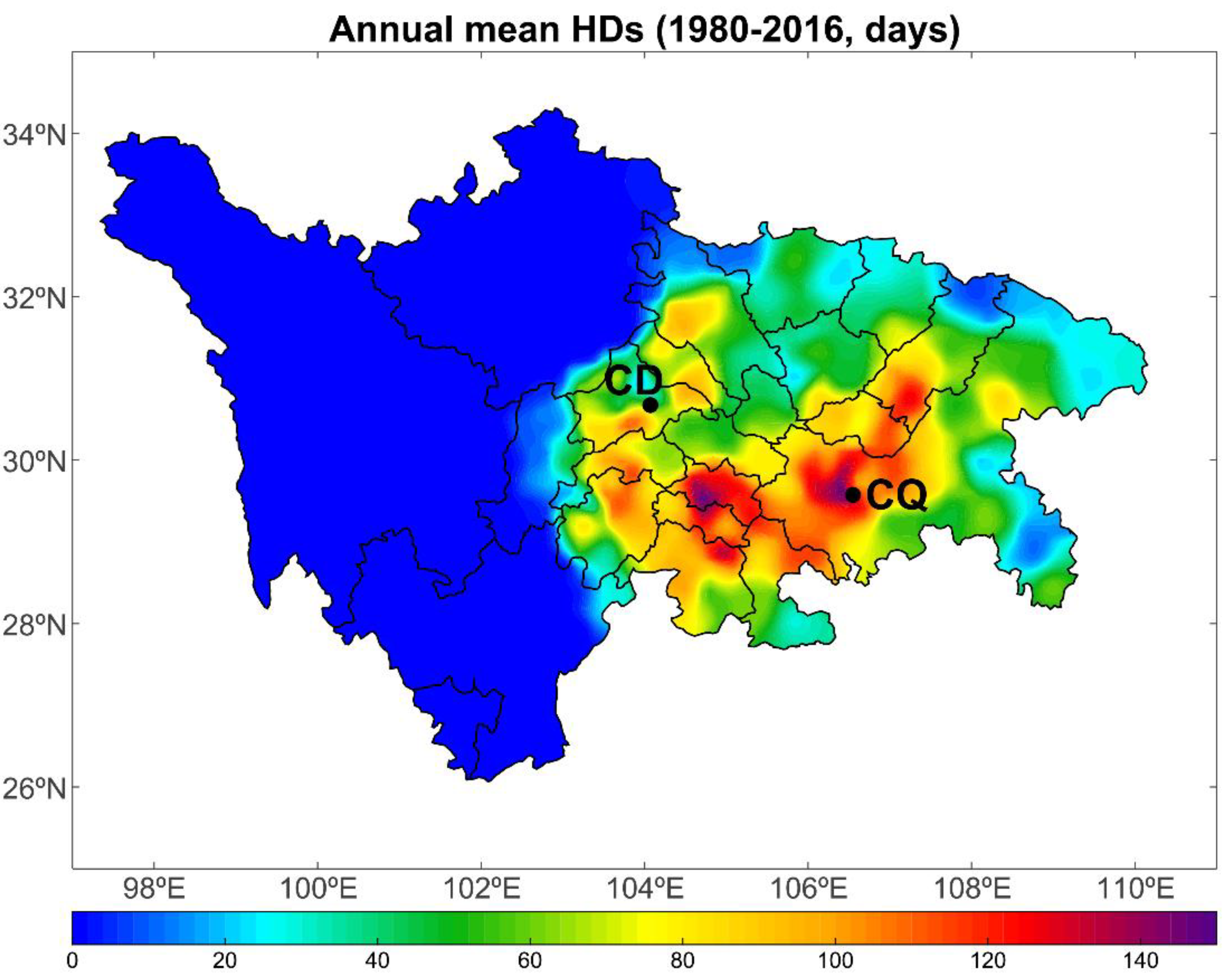
Figure 3 presents an overview of the annually haze days (HDs) in the Sichuan-Chongqing (SCC) region averaged over 1980 to 2016. Overall, most haze events in the SCC region occur in SCB. The annual mean number of HDs for all stations in the Sichuan Basin (SCB) was 68.7 days, which is slightly higher than the 63.5 days in SCB between 1980 and 2012 reported in previous study [39] and 4.9 days for those in the rest of SCC region. Overall, observed haze most frequently occurs in the southern and central regions of SCB, while relatively few HDs were located mainly in western plateau of SCC region and the northern and eastern parts of SCB. More specifically, the areas with more than 100 HDs per year were centered mainly in ZG, YB, LZ, NC, GA, LS, CD, DZ, and CQ, all of which are the main densely populated and industrialized areas over SCB with low elevations and high anthropogenic emissions. In contrast, as a result of high elevation, sparse population and limit industrial aerosol emissions, there are few haze events in western Sichuan Plateau and Panxi Plateau. In general, the spatial distribution of HDs over the SCC region is mainly determined by the distribution of pollutant emissions and by the topographic characteristics of the SCC region.
Figure 4 shows the spatial distribution of 37-year seasonal mean HDs over SCC regions. The spatial distribution of seasonal mean HDs was similar to the spatial pattern of the multi-year averaged HDs, but the number of seasonal mean HDs in SCB varies from spring to winter, and the number of HDs was 11.6, 5.5, 17.0, and 34.7 days for spring, summer, autumn, and winter, respectively. In contrast, the number of HDs in the rest of SCC was 0.87, 0.30, 1.1, and 2.7 days for spring, summer, autumn, and winter, respectively. Significant variations in seasonal mean HDs from season to season are found in the southern SCB, which was generally associated with the variation in occurrence of extremely stagnant weather condition as well as the seasonal variation in regional anthropogenic pollutant emission [40] (also see Figure S1). This seasonal pattern of HDs shows that winter may be the most polluted season over SCB, which is attributed to the enhanced pollutant emissions produced by both coal burning and vehicle emissions in winter. In addition, the frequent air stagnation events in winter over SCB also contributed largely to the increase in HDs [30,41]. The lowest HDs occurred in summer, which can be explained by stronger wet deposition owing to frequent precipitation and by the favorable atmospheric diffusion conditions, including the increase of wind speed and planetary boundary layer height.

3.2. Inter-Annual Variation in Haze Days in Main Cities

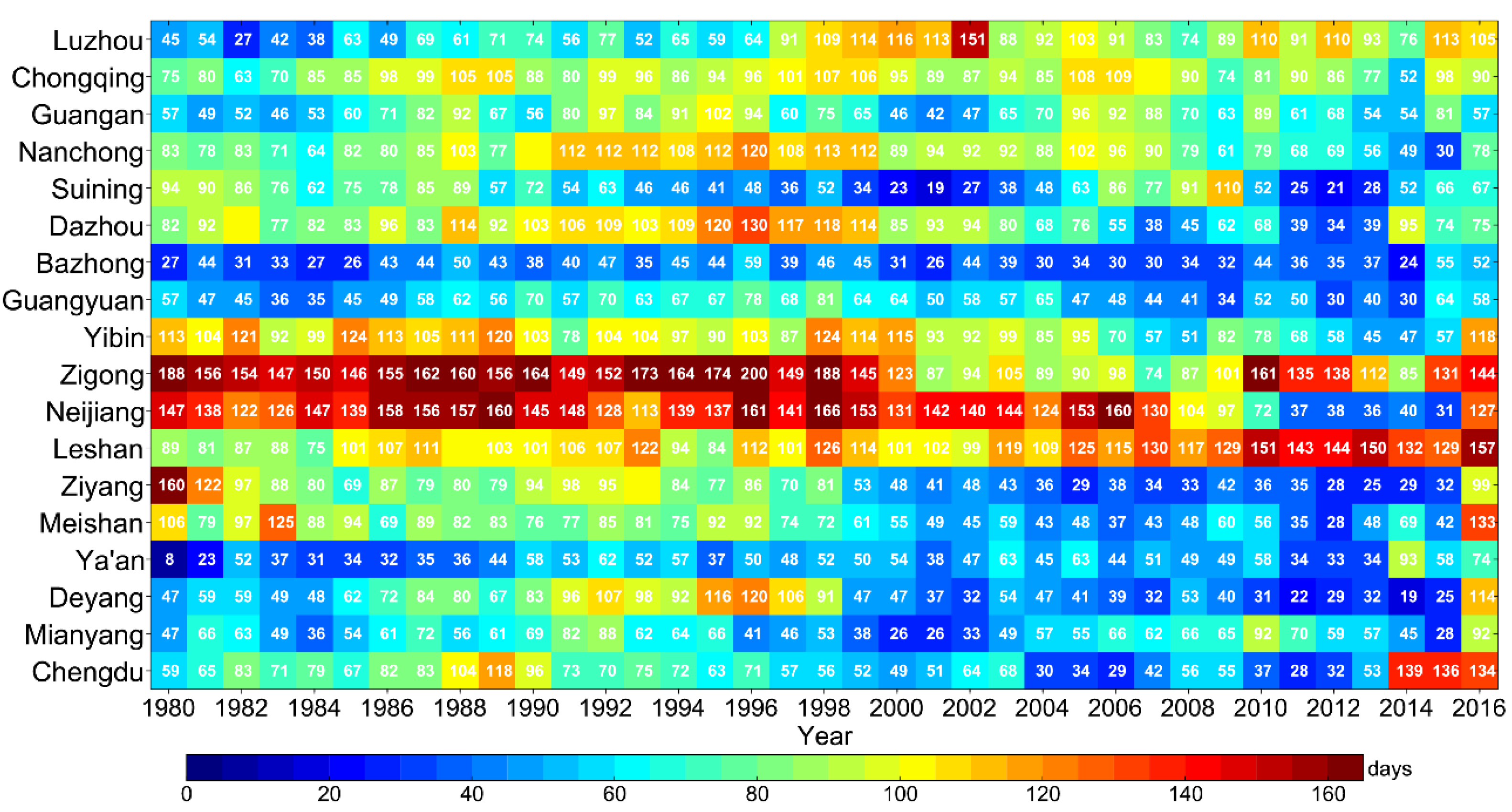
Figure 5 shows the annual variations in HDs in 18 main cities (see Figure 1b) over SCB from 1980 to 2016. The annual variations in HDs in SCB varied widely depending on the location of these observation sites, but the pollution levels of these sites basically represent the overall pollution level of the major cities in SCB. For the entire study period, the high-value centers of HDs mainly occurred at ZG, NJ and YB in the southern part of SCB, whereas the low-value centers of HDs were observed at BZ, GY and YA. More specifically, during the period of 1980–1990, the annual mean HDs were 157, 145, 110, 94, 94, 91, 90, 87, 81 days in ZG, NJ, YB, LS and ZY, MS, DZ, CQ, and CD, respectively, much higher than those in NC (80 days), SN (79 days), GA (63 days), DY (63 days), MY (57 days), LZ (52 days), GY (49 days), BZ (37 days), and YA (33 days). From 1991 to 2005, the reduction in HDs was found at all cities except LZ, LS, NJ, CQ and YB, with an annual average increase rate of 4.4, 0.7, 0.5, 0.3 and 0.1 days/year, respectively. After 2005, annual mean HDs increased at an annual rate of 10.4, 2.1, 2.3, 4.4, 2.2, 2.6, 4.1, 1.2, 0.8, 1.6, 2.9, and 1.9 days/year in CD, DY, YA, MS, ZY, LS, ZG, YB, GY, BZ, DZ, and LZ, respectively. In contrast, the reduction in HDs between 2006 and 2016 was observed at MY, NJ, SN, NC, GA, and CQ, with an annual average decrease rate of 1.1, 8.3, 4.1, 4.0, 2.6, and 1.9 days/year, respectively. Furthermore, the seasonal evolution characteristics of HDs in these 18 main cities are basically consistent with the annual variations of HDs (Figure S2). Comparing the number of HDs between seasonal and annual, we found that increased HDs in winter have contributed significantly to the total number of annual HDs (Figure S2).
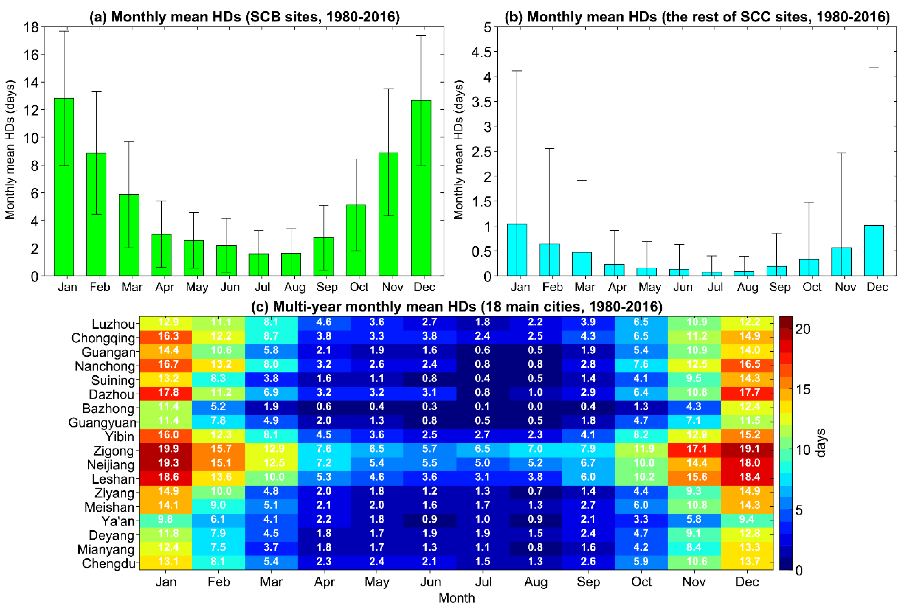
The multi-year monthly mean HDs at all sites in SCB and those in the rest of SCC are shown in Figure 6a,b. For all sites in SCB, the maximum seasonal mean HDs were found in winter (December to February), with the monthly mean HDs of 12.9, 9.0, and 12.8 days for January, February, and December, respectively, while the minimum HDs were found in summer, with the monthly mean HDs of 2.2, 1.6, and 1.7 days for June, July, and August, respectively. A similar pattern is found for all sites in the rest of SCC, with a much smaller number of expected HDs. In addition, Figure 6c also presents the multi-year (1980–2016) monthly variation in HDs in 18 main cities. Overall, the maximum monthly HDs for all 18 main cities mainly occurred in winter. More specifically, the high-value of monthly HDs with more than half of month (i.e., about 15 days) mainly occurred in January at LS (18.6 days), NJ (19.3 days), ZG (19.9 days), YB (16.0 days), DZ (17.8 days), NC (16.7 days), and CQ (16.3 days), and in December at LS (18.4 days), NJ (18.0 days), ZG (19.1 days), DZ (17.7 days), and NC (16.5 days). It is worth noting that ZG, NJ, and LS show the largest number of HDs in per month, indicating that these areas are the most polluted areas in SCB for the past 36 years.

3.3. The Annual and Seasonal Trends of Haze Days

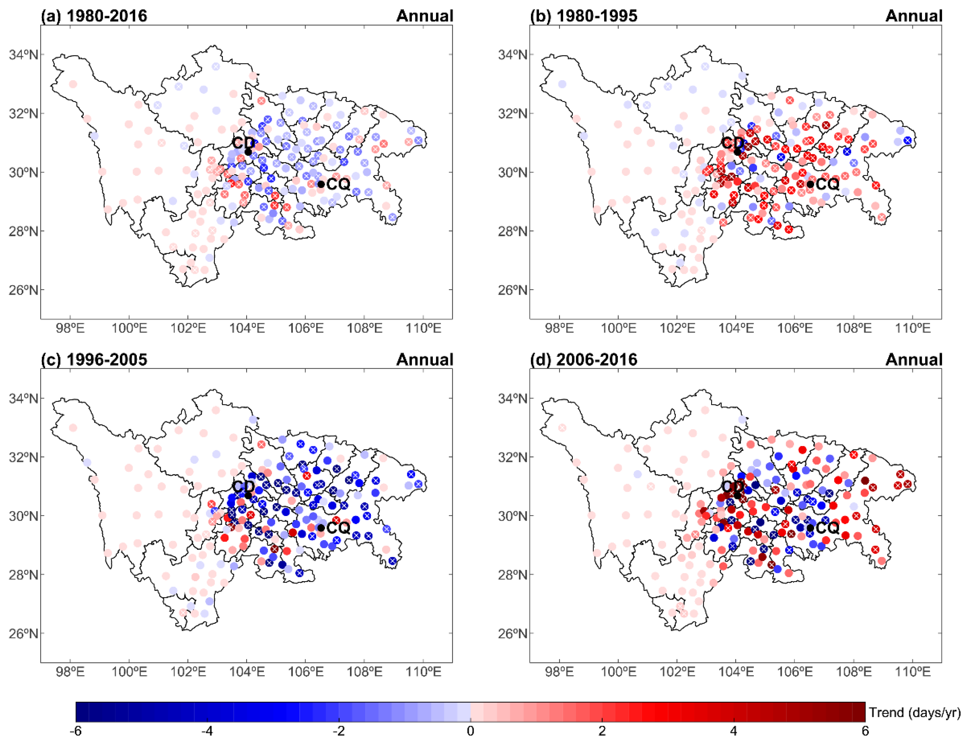
Based on the long-term HDs data derived from 179 observation stations in the SCC region, we calculated trends in annual HDs during the entire study period (1980–2016) and three different periods: 1980–1995, 1996–2005, and 2006–2016. During the entire period (1980–2016), there is a moderately decreased trend over SCB, while a slightly increased trend was found over the western plateau area of SCC (Figure 7a). The trends in annual HDs vary in the three different periods. For instance, during 1980–1995, there is a general consistent increasing trend of annual HDs in SCB, with the number of sites displaying statistically significant increasing trends, reaching 66 at the 95% confidence level (Table 1). Seasonal HDs also showed similar increasing trends at most sites (see Figures S3–S6). The number of sites displaying statistically significant increasing trends are 52, 32, 66, and 28 for spring, summer, autumn, and winter, respectively (Table 1). In the second period (1996–2005), there is a notable decreasing trend at almost all sites in SCB, with the number of sites displaying statistically significant (at the 95% confidence level) decreasing trends reached 46. Seasonal HDs, except for summer, also showed similar increasing trends at most sites for 1996–2005 (Figures S3–S6). The number of sites displaying statistically significant decreasing trends is 41, 11, 21, and 33 for spring, summer, autumn, and winter, respectively.
During the recent period (2006–2016), the linear trend of station HDs presents a more complex spatial distribution pattern, whether it is annual or seasonal. For instance, on the basis of year, there are generally increasing trends in some sites, including the surrounding cities of CD and the eastern sites of CQ, but there are some decreasing trends around CQ. Statistically, the number of sites displaying statistically significant decreasing (increasing) trends are 17 (24) over SCC region. On the basis of season, a similar pattern is observed in spring and autumn, although the intensity of the trend is reduced (Figures S3 and S5). In summer, most of the sites over SCC show a significant decreasing trend, with the greatest decreases occurring in the southern part of SCB and the Chongqing region (Figure S4). In contrast, significant increasing trends are found in winter in most cities throughout SCC region (Figure S6). The number of sites displaying statistically significant increasing trends reached 46, indicating that the SCB is experiencing increasing haze pollution in the last decade.
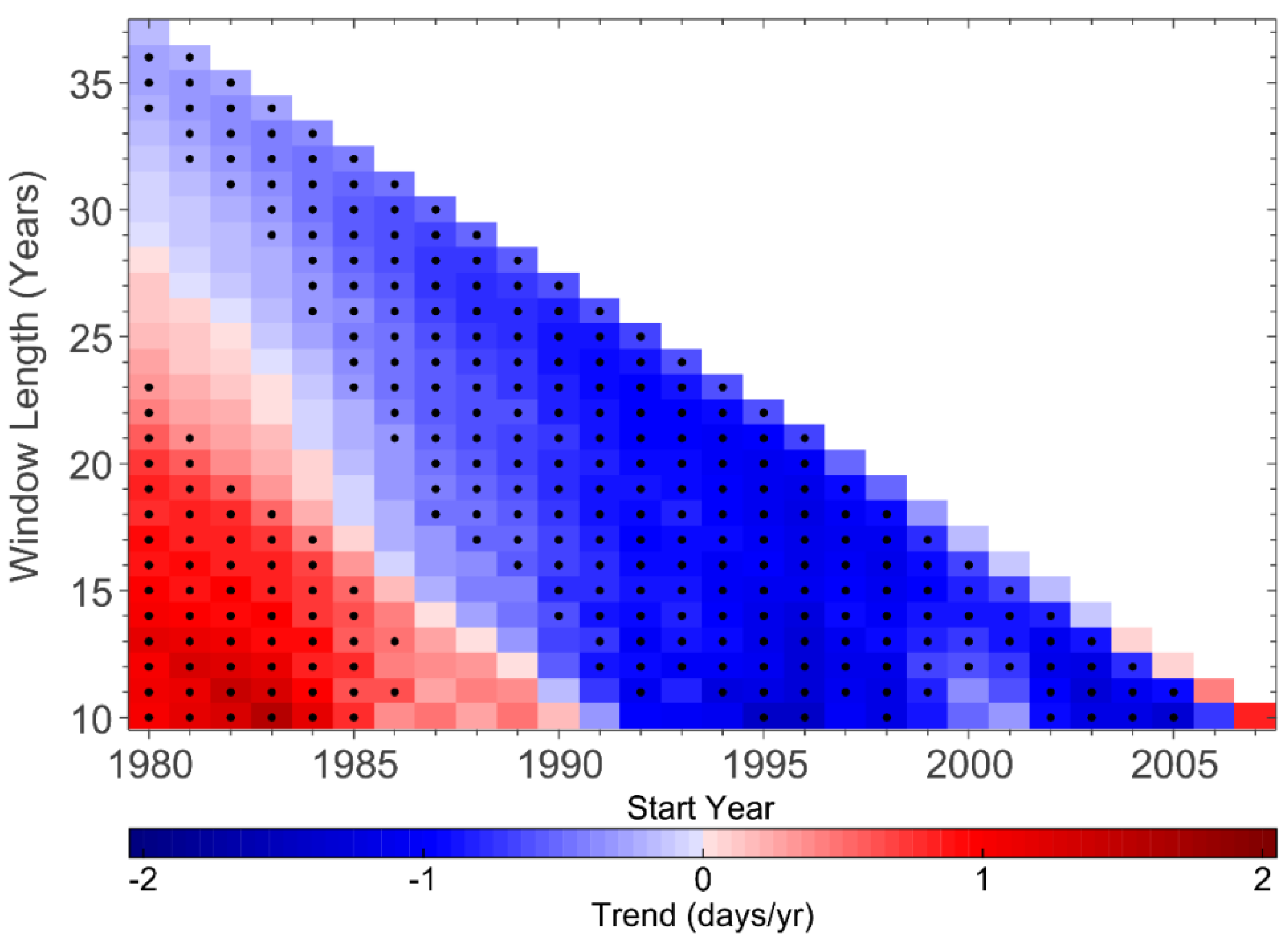
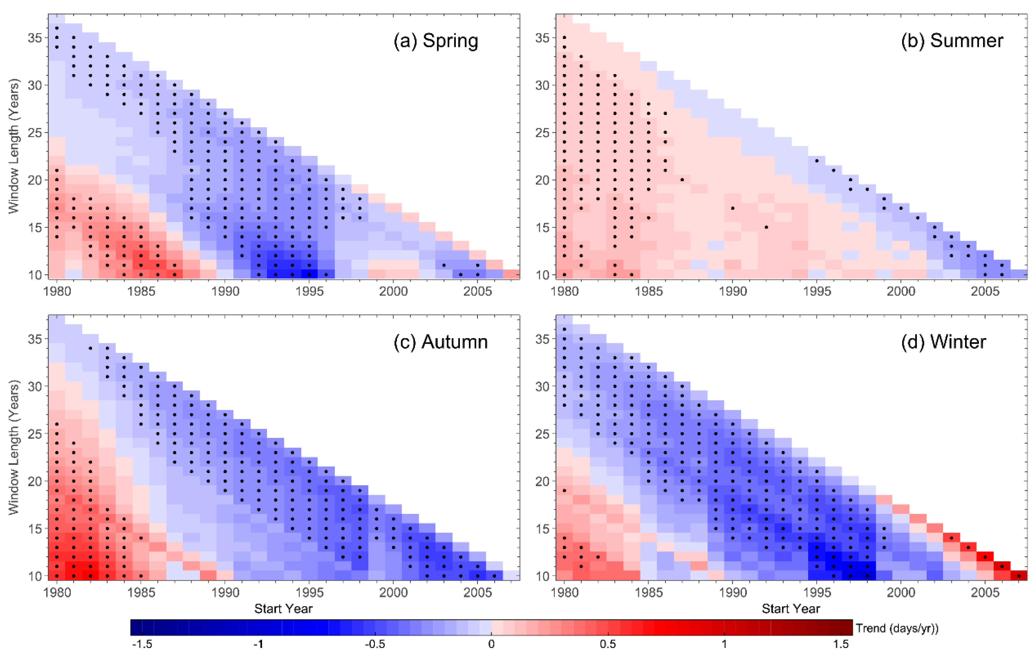
In order to comprehensively estimate the trends of HDs during different historical periods, a running window trend analysis for annual and seasonal HDs over SCC region was conducted (Figure 8 and Figure 9). The trends are calculated for different historical periods starting from 1980 to 2007 and ending in 2016, with at least 10-year span. As presented in Figure 8, the annual HDs over SCC region experienced a significant increase reaching 1.0 days/yr until the 1985–1994 period. Then, there was a significant decrease since 1996. Furthermore, compared with the annual trend pattern, seasonal trend patterns show completely different characteristics (Figure 9). In spring, there was a moderate increasing trend of HDs in the 1980s, and then the trend sharply reversed in the 1990s, while it decreased fluctuating after 2004. The HDs in summer showed a slightly sustained increase starting from 1980 to 1986 and ending in 2016, and then the trend maintained stable between 1986 and 2002, while it suddenly significantly decreased over the last decade. In autumn, there is an overall positive trend starting from 1980 to 1985 and ending in the year with time window less than 15 years, whereas the trend showed the persistent negative value after 1991. The HDs in winter experienced the moderate increase in the 1980s, and then significantly reduced until 2000, whereas it remarkably increased after 2006.

3.4. The Impacts of Emission and Meteorology on Haze Days

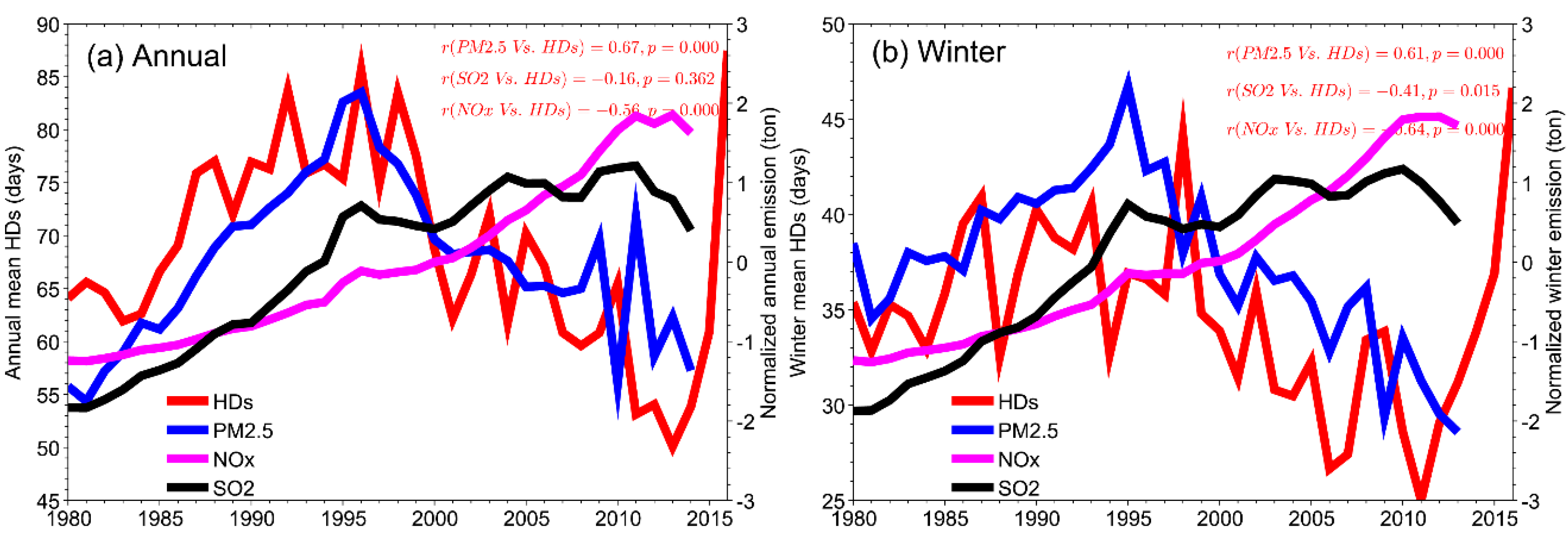
After a comprehensive analysis of the trend in HDs during different historical periods, we are now trying to explore the potential relationships between inter-annual variation in HDs and the changes in the emissions and meteorological elements. Figure 7 and Figure S3–S6 have demonstrated that the calculated trends in HDs over the SCC region are dominated by SCB. Meanwhile, as has been indicated, the number of HDs in winter contributed more than 50% of annual HDs (see Figure 4); hence we focus our analysis on the basic of annual and winter in SCB. Figure 10a,b showed the annual and seasonal variations in total anthropogenic emissions of fine particulate matter (PM2.5) from 1980 to 2014 in SCB. In general, the trend of HDs agrees well with that of the PM2.5 emissions, with a high correlation coefficient of 0.67 and 0.61 for annual and winter, respectively. For the shorter periods, this annual correlation coefficient is even greater, reaching 0.82 and 0.84 during 1980–1995 and 1996–2005, respectively. Sulfur dioxide (SO2) and nitrogen oxide (NOx) are the two main precursors of secondary aerosols formed, which are closely related to the occurrence of haze events. Figure 10 also displays the annual and seasonal variations in total anthropogenic emissions of SO2 and NOx from 1980 to 2014 in SCB. The SO2 and NOx show a marked increasing trend during the period of 1980–1996, which is consistent with the trend of HDs. In contrast, NOx and SO2 emissions after 1996 increase to a peak in 2011/2012 and then decrease. Taken together, the increasing trend in HDs during 1980–1995 may be explained by the increase in emissions of multiple pollutants together. In contrast, the decline in emissions of PM2.5 during 1996–2005 may explain significant decreasing trend in HDs. However, an insignificant correlation coefficient between HDs and PM2.5 emission was found for 2006–2014 (Table 2), indicating that anthropogenic emission is not the decisive factor in the change of HDs in recent decade. The variation in HDs between 2006 and 2014 may be influenced by other processes, such as the climate change, which can significantly influence the air pollution via variation of local atmospheric circulation [15].
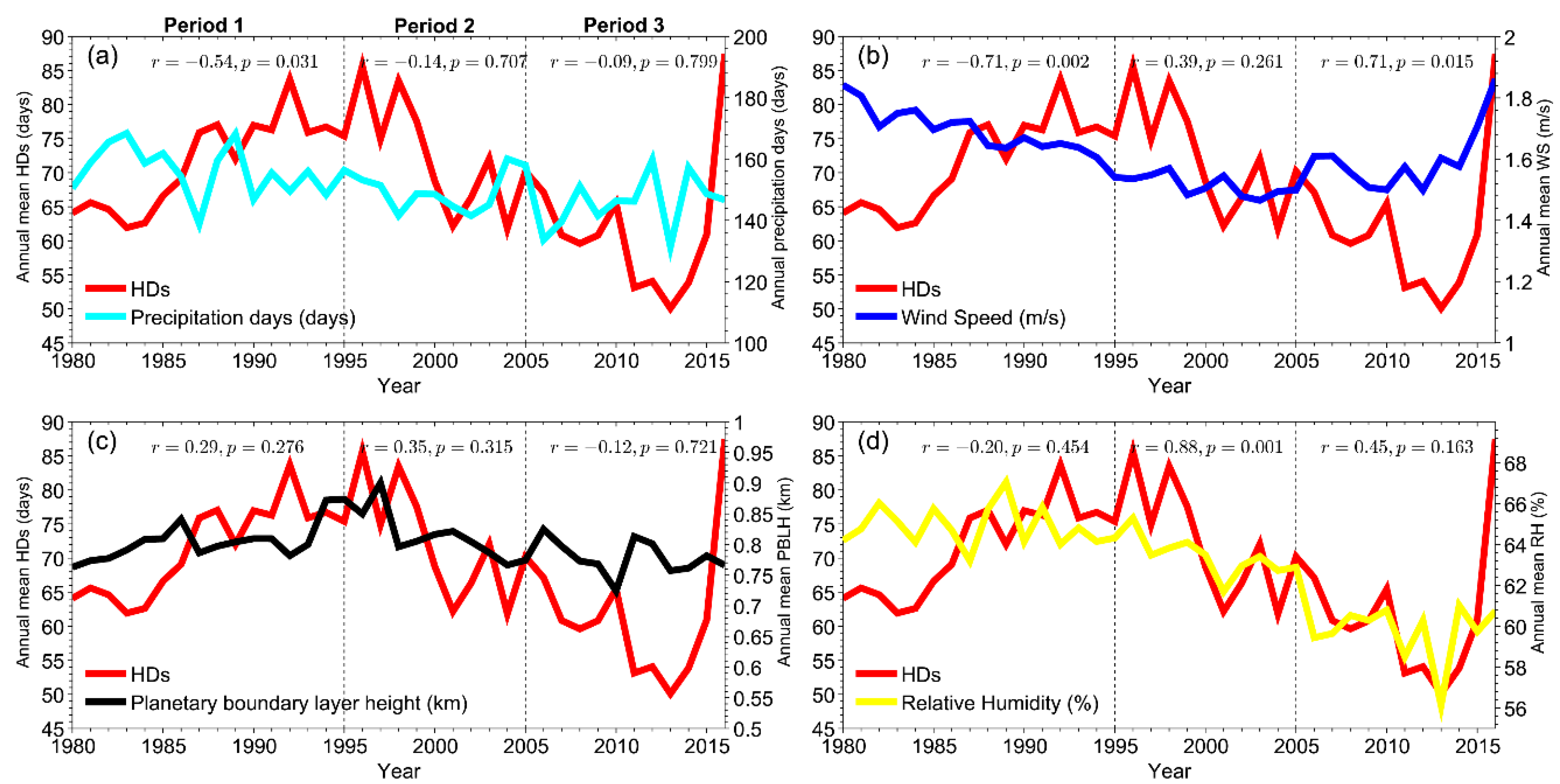
To further explain the variations in HDs, the correlation between HDs and meteorological parameters during the different periods was also examined, results being shown in Figure 11 and Table 2. Note that only those days that are not excluded from the potential HDs can be used in the correlation analysis. It is generally known that precipitation is the major climate factor, which has a significant impact on the haze pollution by the wet scavenging effect of atmospheric pollutants [15]. It is clear that the SCB has a generally decreasing trend of precipitation days (PDs) during 1980–1995 and the HDs–PDs correlation coefficient is −0.54, which is statistical significance at the 95% confidence level. Thus, the decreased PDs as well as the increased emission over SCB favor HDs increasing during 1980–1995 while the effects of precipitation are not significant during other periods. In contrast, a more significant negative correlation was found in winter during the entire study periods (1980–2016) and three independent different periods (Table 2), suggesting that the variation of PDs in winter has a more significant impact on the winter HDs changes in SCB.
In addition, wind speed (WS) and planetary boundary layer height (PBLH) are another two key factors that can control the horizontal transport and vertical diffusion of pollutants [5]. As shown in Figure 11b,c, there is significant reduction of WS during 1980–1995. The annual mean WS averaged at all sites over SCB showed negative correlation with HDs (R = −0.72), which is statistical significance at the 99% confidence level, suggesting that the reduction of WS contributes to the increase in HDs over SCB. Due to the influence of topography (see Figure 1c), the SCB is dominated by low WS, especially in winter with a mean WS of about 1.4 m/s, which is not enough to play an important role in horizontal diffusion of pollutants. Besides, WS does not show a significant upward or downward trend after 1996. Therefore, WS may not be a decisive factor in controlling the inter-decadal variations of HDs in SCB, although a strong positive correlation was found during the period of 2006–2016, it may be caused by the short time period (11 years) and coincidence of positive outliers in 2016. Meanwhile, we found that the winter mean PBLH has a negative correlation with HDs (R = −0.23) during 2006–2016 in SCB. The decreased trend in winter PBLH in the past decade hinders the vertical diffusion of atmospheric aerosol particles, which in turn will lead to further accumulation of pollutants.
Besides, we should not neglect the effects of the changes in relative humidity (RH). As shown in Figure 11d, it is clear that the change in annual mean HDs was almost the same as that of RH for most periods. More specifically, RH keeps gradually increasing during 1980–1990, and then sharply decreasing during 1991–2013, while it unexpectedly increased again after 2013. The increased RH caused an increase in the aerosol water content and resulted in the absorption of semi-volatile components, thereby promoting the hygroscopic growth of aerosol and the formation of ammonium nitrate, which will ultimately contribute to the formation of haze pollution [2,42]. In contrast, the variation of RH has smaller impacts on winter HDs in SCB. In summary, the decreased trends in PDs and WS can explain the significant increase of HDs during 1980–1995 in SCB besides increased anthropogenic emission. During the period of 1996–2005, the significant decrease in HDs is mainly attributable to the reduction of PM2.5 emissions and the increase of PDs (especially in winter), while the decrease of RH can also help to reduce the HDs over SCB. After the year 2006, the change of climate factors is the main reason leading to variation in HDs. The intensified winter HDs during 2006–2016 in SCB is mainly affected by the decrease in PDs.

4. Conclusions

On the basis of observed haze days (HDs) data derived from 179 surface observation stations in SCC region during the past 37 years (1980–2016), this study investigated the spatial distribution of seasonal and annual HDs and its inter-annual variation and trends and examined the impacts of changes in anthropogenic emissions and meteorological factors on variation in HDs during different periods.
Our study shows that haze occurs mostly in SCB depending on the topography of the SCC region and the distribution of population and industrialization. Overall, the annual average number of HDs was 68.7 days in SCB during 1980–2016, whereas it was 4.9 days in the rest of SCC region. Influenced by seasonal variations in anthropogenic emission and local meteorological system, the number of HDs was the maximum in winter (34.7 days), followed by autumn (17.0 days) and spring (11.6 days), and the minimum in summer (5.5 days) over SCB during the entire study period. An investigation into the inter-annual variations of HDs in 18 main cities revealed that the high-value centers of HDs mainly occurred at ZG, NJ, and YB in the southern part of SCB, whereas the low-value of HDs was observed at BZ, GY, and YA. In the 1980s, the maximum number of annual mean HDs was 157, 145, 110, and 94 days in ZG, NJ, YB, and LS, respectively. These top cities with the highest value of HDs remain unchanged and even show a slight upward trend during the period of 1991 to 2005. Since 2006, there has been an increasing trend of HDs at 12 cities, whereas a decreasing trend was observed in the other six cities.
The trend analysis of HDs during three different periods exhibited that there is a general consistent increasing trend of the annual and seasonal HDs in SCB during 1980–1995. In the second period (1996–2005), there is a notable decreasing trend in annual HDs at almost all sites in SCB, while the decreasing trend also occurred in four seasons, except summer. During the recent period (2006–2016), a significant increasing trend is found in winter in most cities throughout SCC region, whereas the trend has been reversed in summer. A more comprehensively running window trend analysis of HDs showed that there are seasonal differences in the actual trends during different historical periods. For example, there is an overall strong positive trend starting from 1980 to 1985 and ending in the year with time window less than 15 years, whereas the trend sharply reversed after 1991. In contrast, the HDs in winter moderately increased in the 1980s and then significantly reduced until 2000, whereas it remarkably increased after 2006.
Analysis of the relationships between HDs and emissions and between HDs and meteorological factors showed that the variation in emissions and meteorological factors play different roles during different historical periods. Specifically speaking, the joint effect of sharp increase of anthropogenic emission and the decrease of PDs and WS intensified the haze pollution in SCB during 1980–1995. In contrast, decreased HDs during 1996–2005 are mainly attributable to the reduction of PM2.5 emission and RH. Meanwhile, the increase of PDs (especially in winter) can also help to reduce the HDs over SCB. In the last decade (2006–2016), the decrease of PDs is likely to be responsible for the unexpected increase in winter HDs over SCB.

Supplementary Materials

The following are available online at https://www.mdpi.com/2073-4433/9/7/277/s1, Figure S1: Seasonal variation in total anthropogenic emissions of PM2.5 (unit: ton) averaged over Sichuan-Chongqing region for 1980–2014, derived from PKU emission inventory, Figure S2: Seasonal number of haze days in 18 main cities of the SCB from 1980 to 2016, Figure S3: Linear trend of station spring haze days in the four periods: (a) 1980–2016, (b) 1980–1995, (c) 1996–2005, and (d) 2006–2016. The circle with a cross means trend above 95% significance level, Figure S4: Same as Figure S3, but for summer, Figure S5: Same as Figure S3, but for autumn, Figure S6: Same as Figure S3, but for winter, Table S1: Base information of the selected 18 main cities in Sichuan Basin. Location of the 18 main cities are presented in Figure 1b.

Author Contributions

H.C. wrote the article; H.C. and Q.C. conceived and designed the experiments; H.C. and K.G. analyzed the data.

Funding

This work was supported by the National Natural Science Foundation of China (41405031, 41475037), the Special Fund for Public Welfare Industry (Meteorology) of China (GYHY201506013), and the Scientific Research Foundation of Chengdu University of Information Technology (KYTZ201504, J201519).

Acknowledgments

We thank two anonymous reviewers for comments and suggestions that led to improvement of the manuscript. The MERRA-2 reanalysis data is available from https://disc.sci.gsfc.nasa.gov/daac-bin/FTPSubset2.pl.

Conflicts of Interest

The authors declare no conflict of interest.

References

  1. Che, H.; Zhang, X.; Li, Y.; Zhou, Z.; Qu, J.J.; Hao, X. Haze trends over the capital cities of 31 provinces in China, 1981–2005. Theor. Appl. Climatol. 2009, 97, 235–242. [Google Scholar] [CrossRef]
  2. Ding, Y.H.; Liu, Y.J. Analysis of long-term variations of fog and haze in China in recent 50 years and their relations with atmospheric humidity. Sci. China Earth Sci. 2014, 57, 36–46. [Google Scholar] [CrossRef]
  3. Han, R.; Wang, S.; Shen, W.; Wang, J.; Wu, K.; Ren, Z.; Feng, M. Spatial and temporal variation of haze in China from 1961 to 2012. J. Environ. Sci. (China) 2016, 46, 134–146. [Google Scholar] [CrossRef] [PubMed]
  4. Tao, M.; Chen, L.; Wang, Z.; Wang, J.; Tao, J.; Wang, X. Did the widespread haze pollution over China increase during the last decade? A satellite view from space. Environ. Res. Lett. 2016, 11. [Google Scholar] [CrossRef]
  5. Cai, W.; Li, K.; Liao, H.; Wang, H.; Wu, L. Weather conditions conducive to Beijing severe haze more frequent under climate change. Nat. Clim. Chang. 2017, 7, 257–262. [Google Scholar] [CrossRef]
  6. Zhang, Y.-L.; Cao, F. Fine particulate matter (PM2.5) in China at a city level. Sci. Rep. 2015, 5, 14884. [Google Scholar] [CrossRef] [PubMed]
  7. Gui, K.; Che, H.; Chen, Q.; An, L.; Zeng, Z.; Guo, Z.; Zheng, Y.; Wang, H.; Wang, Y.; Yu, J.; et al. Aerosol optical properties based on ground and satellite retrievals during a serious haze episode in December 2015 over Beijing. Atmosphere 2016, 7, 70. [Google Scholar] [CrossRef]
  8. Wu, D.; Tie, X.; Li, C.; Ying, Z.; Lau, A.K.H.; Huang, J.; Deng, X.; Bi, X. An extremely low visibility event over the Guangzhou region: A case study. Atmos. Environ. 2005, 39, 6568–6577. [Google Scholar] [CrossRef]
  9. Cohen, A.J.; Brauer, M.; Burnett, R.; Anderson, H.R.; Frostad, J.; Estep, K.; Balakrishnan, K.; Brunekreef, B.; Dandona, L.; Dandona, R.; et al. Estimates and 25-year trends of the global burden of disease attributable to ambient air pollution: An analysis of data from the Global Burden of Diseases Study 2015. Lancet 2017, 389, 1907–1918. [Google Scholar] [CrossRef]
  10. Apte, J.S.; Marshall, J.D.; Cohen, A.J.; Brauer, M. Addressing Global Mortality from Ambient PM2.5. Environ. Sci. Technol. 2015, 49, 8057–8066. [Google Scholar] [CrossRef] [PubMed]
  11. Xie, Y.-B.; Chen, J.; Li, W. An assessment of PM2.5 related health risks and impaired values of Beijing residents in a consecutive high-level exposure during heavy haze days. Environ. Sci. 2014, 35, 1–8. (In Chinese) [Google Scholar]
  12. Xu, P.; Chen, Y.; Ye, X. Haze, air pollution, and health in China. Lancet 2013, 382, 2067. [Google Scholar] [CrossRef]
  13. Health Effects Institute. State of Global Air 2018; Special Report; Health Effects Institute: Boston, MA, USA, 2018. [Google Scholar]
  14. Yang, Y.; Liao, H.; Lou, S. Increase in winter haze over eastern China in recent decades: Roles of variations in meteorological parameters and anthropogenic emissions. J. Geophys. Res. 2016, 121, 13050–13065. [Google Scholar] [CrossRef]
  15. Wang, H.J.; Chen, H.P. Understanding the recent trend of haze pollution in eastern China: Roles of climate change. Atmos. Chem. Phys. 2016, 16, 4205–4211. [Google Scholar] [CrossRef]
  16. Fu, G.Q.; Xu, W.Y.; Yang, R.F.; Li, J.B.; Zhao, C.S. The distribution and trends of fog and haze in the North China Plain over the past 30 years. Atmos. Chem. Phys. 2014, 14, 11949–11958. [Google Scholar] [CrossRef] [Green Version]
  17. Yin, Z.C.; Wang, H.J.; Guo, W.L. Climatic change features of fog and haze in winter over North China and Huang-Huai Area. Sci. China Earth Sci. 2015, 58, 1370–1376. [Google Scholar] [CrossRef]
  18. Yang, Y.; Russell, L.M.; Lou, S.; Liao, H.; Guo, J.; Liu, Y.; Singh, B.; Ghan, S.J. Dust-wind interactions can intensify aerosol pollution over eastern China. Nat. Commun. 2017, 8, 15333. [Google Scholar] [CrossRef] [PubMed]
  19. Zhao, B.; Jiang, J.H.; Gu, Y.; Diner, D.; Worden, J.; Liou, K.N.; Su, H.; Xing, J.; Garay, M.; Huang, L. Decadal-scale trends in regional aerosol particle properties and their linkage to emission changes. Environ. Res. Lett. 2017, 12. [Google Scholar] [CrossRef]
  20. Wang, X.; Dickinson, R.E.; Su, L.; Zhou, C.; Wang, K. PM2.5 Pollution in China and How It Has Been Exacerbated by Terrain and Meteorological Conditions. Bull. Am. Meteorol. Soc. 2017. [Google Scholar] [CrossRef]
  21. Li, Q.; Zhang, R.; Wang, Y. Interannual variation of the wintertime fog-haze days across central and eastern China and its relation with East Asian winter monsoon. Int. J. Climatol. 2016, 36, 346–354. [Google Scholar] [CrossRef]
  22. Zou, Y.; Wang, Y.; Zhang, Y.; Koo, J.-H. Arctic sea ice, Eurasia snow, and extreme winter haze in China. Sci. Adv. 2017, 3, e1602751. [Google Scholar] [CrossRef] [PubMed] [Green Version]
  23. Wang, J.; Zhang, M.; Bai, X.; Tan, H.; Li, S.; Liu, J.; Zhang, R.; Wolters, M.A.; Qin, X.; Zhang, M.; et al. Large-scale transport of PM2.5 in the lower troposphere during winter cold surges in China. Sci. Rep. 2017, 7, 1–10. [Google Scholar] [CrossRef] [PubMed]
  24. Huang, R.J.; Zhang, Y.; Bozzetti, C.; Ho, K.F.; Cao, J.J.; Han, Y.; Daellenbach, K.R.; Slowik, J.G.; Platt, S.M.; Canonaco, F.; et al. High secondary aerosol contribution to particulate pollution during haze events in China. Nature 2015, 514, 218–222. [Google Scholar] [CrossRef] [PubMed] [Green Version]
  25. Sun, T.; Che, H.; Qi, B.; Wang, Y.; Dong, Y.; Xia, X.; Wang, H.; Gui, K.; Zheng, Y.; Zhao, H.; et al. Aerosol optical characteristics and their vertical distributions under enhanced haze pollution events: Effect of the regional transport of different aerosol types over eastern China. Atmos. Chem. Phys. 2018, 18. [Google Scholar] [CrossRef]
  26. Deng, X.; Tie, X.; Wu, D.; Zhou, X.; Bi, X.; Tan, H.; Li, F.; Jiang, C. Long-term trend of visibility and its characterizations in the Pearl River Delta (PRD) region, China. Atmos. Environ. 2008, 42, 1424–1435. [Google Scholar] [CrossRef]
  27. Cheng, Z.; Wang, S.; Jiang, J.; Fu, Q.; Chen, C.; Xu, B.; Yu, J.; Fu, X.; Hao, J. Long-term trend of haze pollution and impact of particulate matter in the Yangtze River Delta, China. Environ. Pollut. 2013, 182, 101–110. [Google Scholar] [CrossRef] [PubMed]
  28. Ning, G.; Wang, S.; Ma, M.; Ni, C.; Shang, Z.; Wang, J.; Li, J. Characteristics of air pollution in different zones of Sichuan Basin, China. Sci. Total Environ. 2018, 612, 975–984. [Google Scholar] [CrossRef] [PubMed]
  29. Chen, Y.; Xie, S. Temporal and spatial visibility trends in the Sichuan Basin, China, 1973 to 2010. Atmos. Res. 2012, 112, 25–34. [Google Scholar] [CrossRef]
  30. Liao, T.; Gui, K.; Jiang, W.; Wang, S.; Wang, B.; Zeng, Z.; Che, H.; Wang, Y.; Sun, Y. Air stagnation and its impact on air quality during winter in Sichuan and Chongqing, southwestern China. Sci. Total Environ. 2018, 635, 576–585. [Google Scholar] [CrossRef] [PubMed]
  31. Liao, T.; Wang, S.; Ai, J.; Gui, K.; Duan, B.; Zhao, Q.; Zhang, X.; Jiang, W.; Sun, Y. Heavy pollution episodes, transport pathways and potential sources of PM2.5during the winter of 2013 in Chengdu (China). Sci. Total Environ. 2017, 584–585, 1056–1065. [Google Scholar] [CrossRef] [PubMed]
  32. Liu, X.; Chen, Q.; Che, H.; Zhang, R.; Gui, K.; Zhang, H.; Zhao, T. Spatial distribution and temporal variation of aerosol optical depth in the Sichuan basin, China, the recent ten years. Atmos. Environ. 2016, 147, 434–445. [Google Scholar] [CrossRef]
  33. Guo, X.; Chen, Q.; Zhao, T.; Zheng, X. Climate characteristics of haze and its impacting factors from 1961 to 2010 in Sichuan basin. J. Meteorol. Environ. 2014, 30, 100–107. (In Chinese) [Google Scholar]
  34. Liu, X.; Ren, Z. Progress in quality control of surface meteorological data. Meteor. Sci. Technol. 2005, 33, 199–203. (In Chinese) [Google Scholar]
  35. Vautard, R.; Yiou, P.; Van Oldenborgh, G.J. Decline of fog, mist and haze in Europe over the past 30 years. Nat. Geosci. 2009, 2, 115–119. [Google Scholar] [CrossRef]
  36. Chen, H.; Wang, H. Haze days in North China and the associated atmospheric circulations based on daily visibility data from 1960 to 2012. J. Geophys. Res. Atmos. 2015, 120, 5895–5909. [Google Scholar] [CrossRef]
  37. Huang, Y.; Shen, H.; Chen, Y.; Zhong, Q.; Chen, H.; Wang, R.; Shen, G.; Liu, J.; Li, B.; Tao, S. Global organic carbon emissions from primary sources from 1960 to 2009. Atmos. Environ. 2015, 122, 505–512. [Google Scholar] [CrossRef]
  38. Buchard, V.; Randles, C.A.; da Silva, A.M.; Darmenov, A.; Colarco, P.R.; Govindaraju, R.; Ferrare, R.; Hair, J.; Beyersdorf, A.J.; Ziemba, L.D.; et al. The MERRA-2 aerosol reanalysis, 1980 onward. Part II: Evaluation and case studies. J. Clim. 2017, 30, 6851–6872. [Google Scholar] [CrossRef]
  39. Zhou, W.; Kang, L.; Hao, L. Characteristic analysis of haze in Sichuan Basin and typical cities from 1980 to 2012. China Environ. Sci. 2017, 37, 4–12. (In Chinese) [Google Scholar]
  40. Zhang, Y.; Ding, A.; Mao, H.; Nie, W.; Zhou, D.; Liu, L.; Huang, X.; Fu, C. Impact of synoptic weather patterns and inter-decadal climate variability on air quality in the North China Plain during 1980–2013. Atmos. Environ. 2016, 124, 119–128. [Google Scholar] [CrossRef]
  41. Wang, X.; Wang, K.; Su, L. Contribution of Atmospheric Diffusion Conditions to the Recent Improvement in Air Quality in China. Sci. Rep. 2016, 6, 1–11. [Google Scholar] [CrossRef] [PubMed]
  42. Dawson, J.P.; Adams, P.J.; Pandis, S.N. Sensitivity of PM2.5 to climate in the Eastern U.S.: A modeling case study. Atmos. Chem. Phys. 2007, 7, 4295–4309. [Google Scholar] [CrossRef]
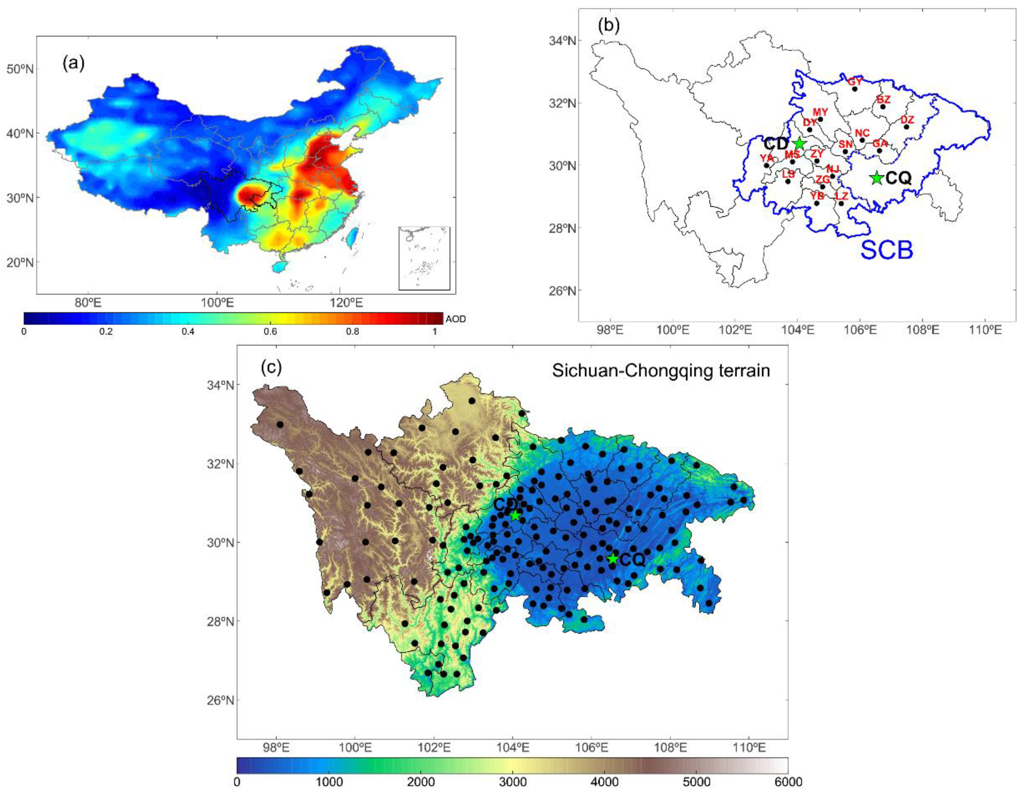
Figure 1. (a) Location of the Sichuan-Chongqing region (black border) and the spatial distribution of annual mean MODIS/Terra aerosol optical depth (AOD) at 550 nm for the period 2001–2016 (shading; units: non-dimensional); (b) Location of the Sichuan Basin (blue border) and 18 main cities; (c) The terrain of Sichuan-Chongqing (shading; unit: m) and the locations of 179 observation stations (black dots).
Atmosphere 09 00277 g001
Figure 2. Validation of haze days (HDs) against PM2.5 concentration at the 18 main cities of SCB in 2016. (ac) The spatial distribution of annual HDs, distribution of annual mean PM2.5 concentration collocating with the nearest observation stations, and the correlation coefficients between monthly HDs and monthly mean PM2.5 concentration.
Atmosphere 09 00277 g002
Figure 3. Spatial distributions of the annual mean HDs over the Sichuan-Chongqing region for 1980–2016.
Atmosphere 09 00277 g003
Figure 4. Spatial distributions of the seasonal mean HDs over the Sichuan-Chongqing region for 1980–2016.
Atmosphere 09 00277 g004
Figure 5. The annual variations of HDs in 18 main cities of SCB from 1980 to 2016.
Atmosphere 09 00277 g005
Figure 6. The multi-year (1980–2016) monthly mean variations in HDs averaged (a) for all stations in SCB and (b) for those in the rest of SCC region. (c) The monthly mean variations in HDs in 18 main cities of SCB for 1980–2016.
Atmosphere 09 00277 g006
Figure 7. Linear trend of station annual HDs for the four periods: (a) 1980–2016; (b) 1980–1995; (c) 1996–2005; and (d) 2006–2016. The circle with a cross means trend above 95% significance level.
Atmosphere 09 00277 g007
Figure 8. The running trend analysis for annual mean HDs at all stations starting from 1980 to 2007 and ending in 2016, with at least 10-year span required to calculate the trend. The x axis and y axis indicate the start year and the length of the time series to calculate trend, respectively. The color of rectangle represents the intensity of the trend, and those with black dots mean trends above 95% significance level.
Atmosphere 09 00277 g008
Figure 9. Same as Figure 8b, but for seasonal.
Atmosphere 09 00277 g009
Figure 10. The time series of observed HDs (red line) and normalized anthropogenic emissions of PM2.5 (blue line), NOx (magenta line), and SO2 (black line) for annual (a) and winter (b) averaged over SCB from 1980 to 2014. The correlation coefficients between HDs and emissions for 1980–2014 are also given in the top panels.
Atmosphere 09 00277 g010
Figure 11. Correlation between annual mean time series of HDs and the four key meteorological parameters, including (a) relative humidity at surface; (b) wind speed; (c) precipitation; and (d) planetary boundary layer height, averaged over all stations in SCB for the three periods: 1980–1995, 1996–2005, and 2006–2016. Note that the excluded days are not included in the correlation analysis.
Atmosphere 09 00277 g011
Table 1. Number of sites displaying statistically significant (at the 95% confidence level) increasing/decreasing trend.
IncreaseDecrease
1980–2016Annual3252
Spring2443
Summer2917
Autumn2224
Winter3042
1980–1995Annual6615
Spring529
Summer324
Autumn661
Winter289
1996–2005Annual1046
Spring241
Summer1111
Autumn521
Winter533
2006–2016Annual2417
Spring1812
Summer223
Autumn1117
Winter461
Table 2. Correlation coefficients between spatially averaged HDs and meteorological parameters and PM2.5 emission over SCB for the four periods: (a) 1980–2016, (b) 1980–1995, (c) 1996–2005, and (d) 2006–2016.
Emission and Meteorological Parameters1980–20161980–19951996–20052006–2016
AnnualWinterAnnualWinterAnnualWinterAnnualWinter
PM2.5 emission0.67 **0.61 **0.82 **0.300.84 **0.41−0.01−0.11
Precipitation days0.01−0.43 **−0.54 **−0.72 **−0.14−0.71 **−0.09−0.47 *
Wind speed0.110.12−0.71 **−0.090.39−0.59 **0.71 **0.72
Planetary boundary layer height0.34 **−0.090.29−0.340.350.54−0.12−0.23
Relative humidity0.57 **0.17−0.20−0.380.88 **−0.300.45−0.04
* and ** indicate statistical significance at the 90% and 95% confidence level, respectively. Note that only PM2.5 emission data from 1980 to 2014 is used to calculate correlation coefficient.