Contemporary Pyrogeography and Wildfire-Climate Relationships of South Dakota, USA

Abstract
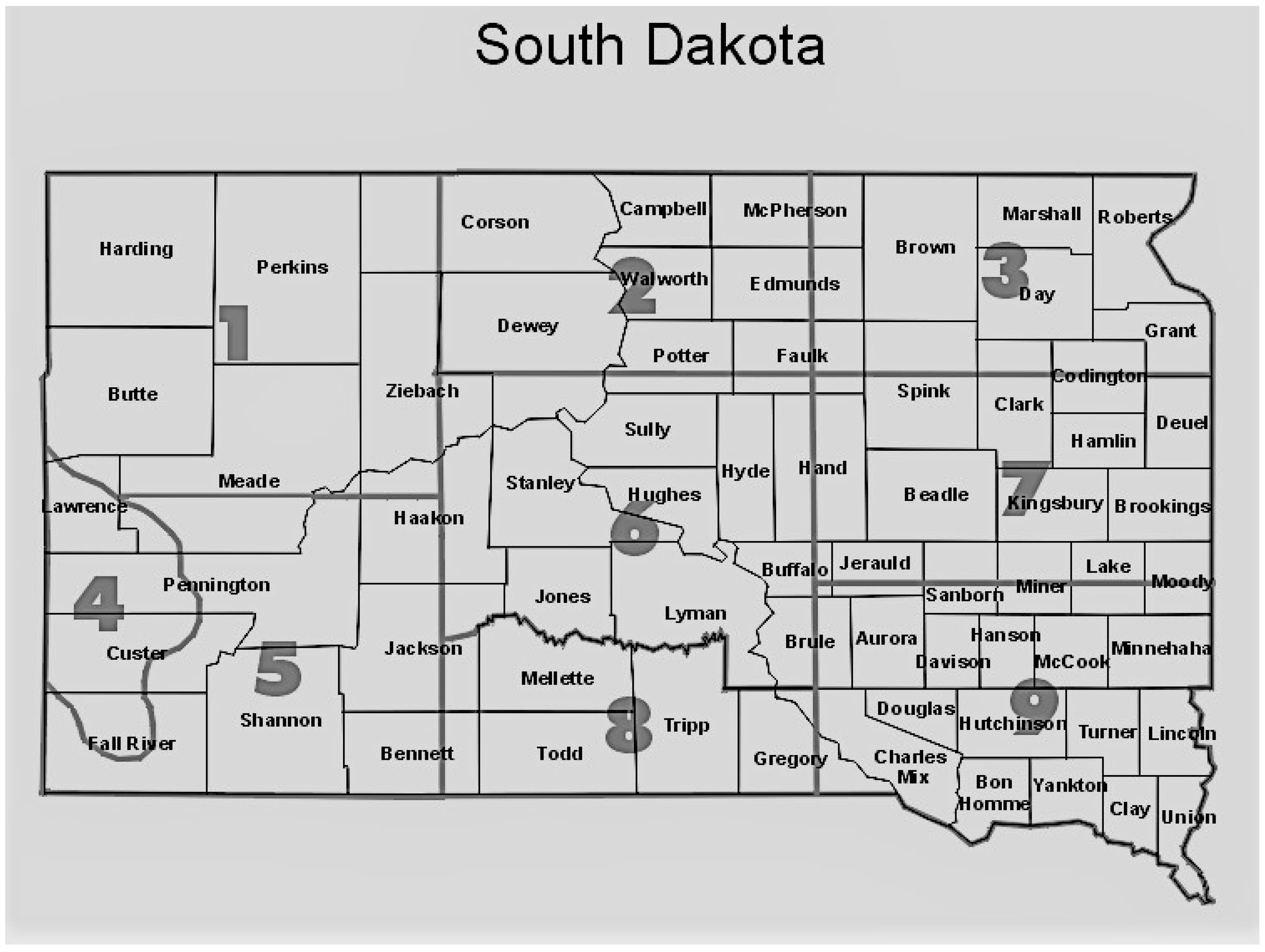
:1. Introduction
2. Experiments
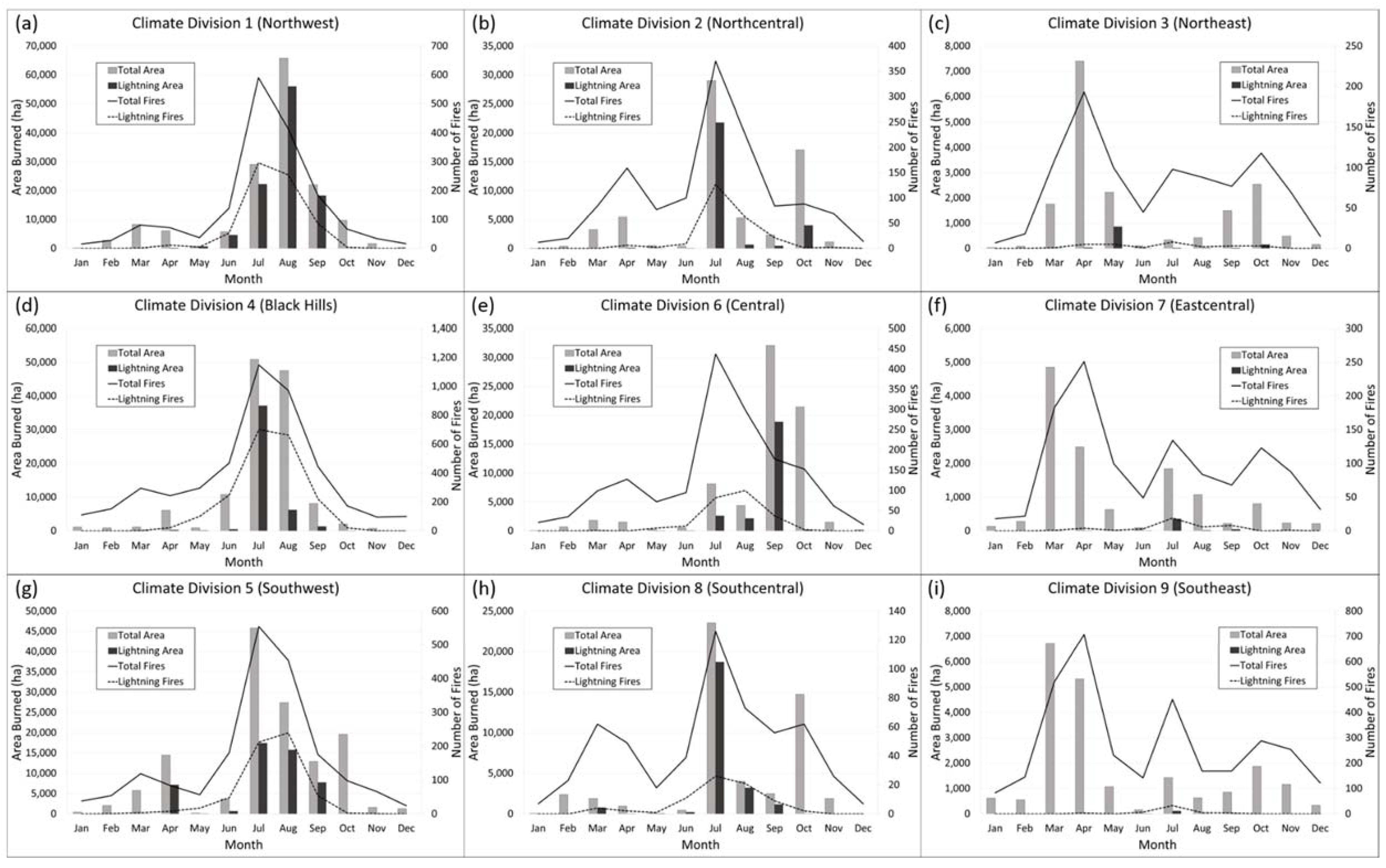
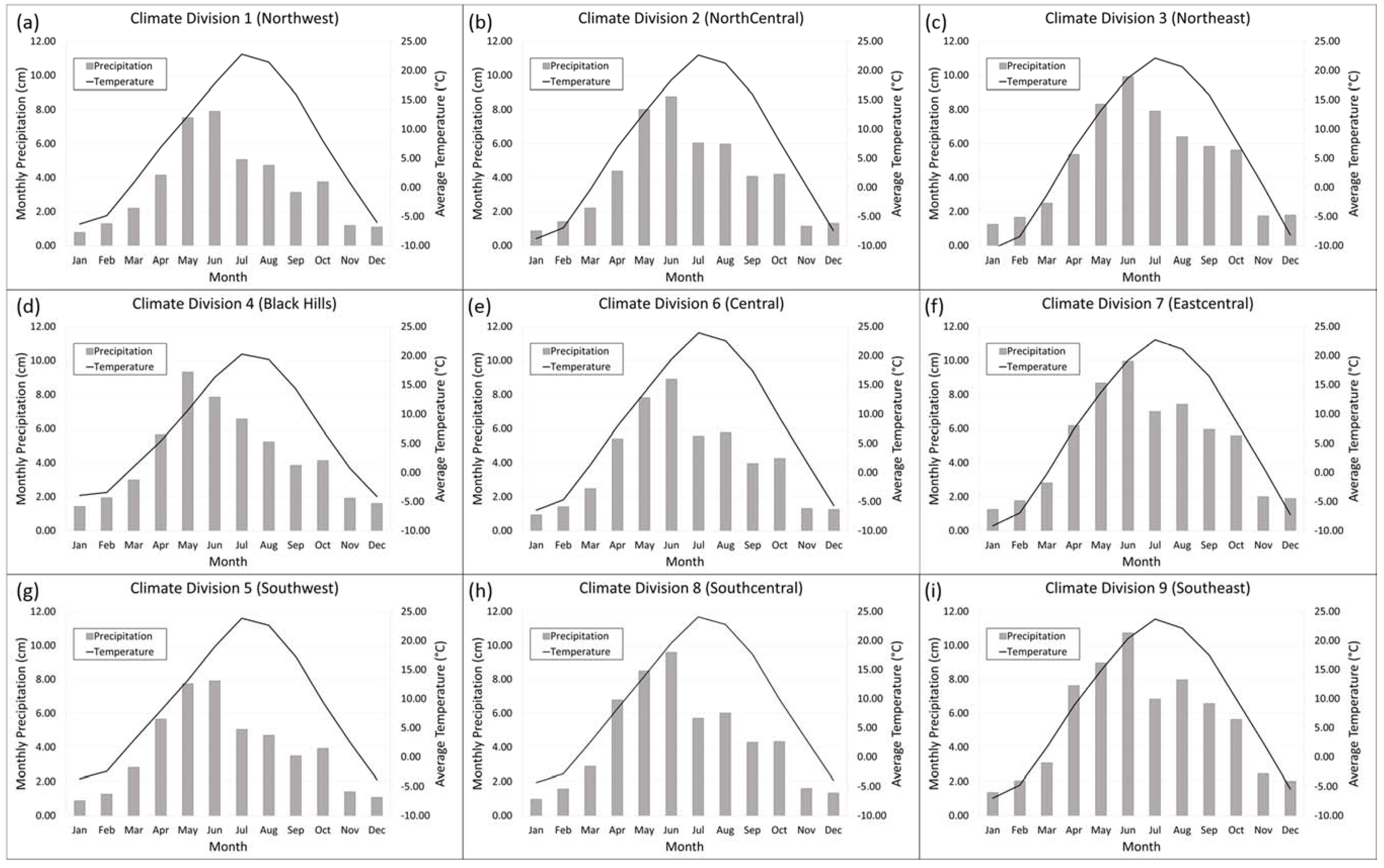
3. Results
4. Discussion
4.1. Drought
4.2. Temperature
4.3. Precipitation
4.4. Ignitions vs. Area Burned
4.5. Other Factors
5. Conclusions
Acknowledgments
Conflicts of Interest
References
- Rohli, R.V.; Vega, A.J. Climatology, 2 ed.; Jones & Bartlett Learning: Burlington, MA, USA, 2012; p. 425. [Google Scholar]
- Johnson, E.A. Fire and Vegetation Dynamics: Studies from the North American Boreal Forest; Cambridge University Press: New York, NY, USA, 1992; p. 129. [Google Scholar]
- Ryan, K.C. Global Change and Wildland Fire; U.S. Department of Agriculture, Forest Service, Rocky Mountain Research Station: Fort Collins, CO, USA, 2000; p. 257.
- Flannigan, M.D.; Wotton, B.M. Climate, Weather, and Area Burned; Academic Press: San Diego, CA, USA, 2001; p. 594. [Google Scholar]
- Guyette, R.P.; Muzika, R.-M.; Dey, D.C. Dynamics of an anthropogenic fire regime. Ecosystems 2002, 5, 472–486. [Google Scholar]
- Yang, J.; He, H.S.; Shifley, S.R.; Gustafson, E.J. Spatial patterns of modern period human-caused fire occurrence in the Missouri Ozark Highlands. For. Sci. 2007, 53, 1–15. [Google Scholar]
- Krawchuk, M.A.; Moritz, M.A.; Parisien, M.-A.; Van Dorn, J.; Hayhoe, K. Global pyrogeography: The current and future distribution of wildfire. PLoS ONE 2009, 4, e5102. [Google Scholar] [CrossRef] [PubMed]
- Moritz, M.A.; Parisien, M.-A.; Batllori, E.; Krawchuk, M.A.; Van Dorn, J.; Ganz, D.J.; Hayhoe, K. Climate change and disruptions to global fire activity. Ecosphere 2012, 3, 1–22. [Google Scholar] [CrossRef]
- Lehmann, C.E.; Anderson, T.M.; Sankaran, M.; Higgins, S.I.; Archibald, S.; Hoffmann, W.A.; Hanan, N.P.; Williams, R.J.; Fensham, R.J.; Felfili, J. Savanna vegetation-fire-climate relationships differ among continents. Science 2014, 343, 548–552. [Google Scholar] [CrossRef] [PubMed]
- Jolly, W.M.; Cochrane, M.A.; Freeborn, P.H.; Holden, Z.A.; Brown, T.J.; Williamson, G.J.; Bowman, D.M. Climate-induced variations in global wildfire danger from 1979 to 2013. Nat. Commun. 2015, 6, 7537. [Google Scholar] [CrossRef] [PubMed]
- Lucas, C.; Hennessy, K.; Mills, G.; Bathols, J. Bushfire weather in southeast Australia: Recent trends and projected climate change impacts. In Consultancy Report Prepared for The Climate Institute of Australia; Bushfire Cooperative Research Centre: Melbourne, Australia, 2007. [Google Scholar]
- Riaño, D.; Moreno Ruiz, J.; Isidoro, D.; Ustin, S. Global spatial patterns and temporal trends of burned area between 1981 and 2000 using NOAA-NASA pathfinder. Glob. Chang. Biol. 2007, 13, 40–50. [Google Scholar] [CrossRef]
- Bartlein, P.J.; Hostetler, S.W.; Shafer, S.L.; Holman, J.O.; Solomon, A.M. Temporal and spatial structure in a daily wildfire-start data set from the western United States (1986–96). Int. J. Wildland Fire 2008, 17, 8–17. [Google Scholar] [CrossRef]
- Westerling, A.L.; Gershunov, A.; Brown, T.J.; Cayan, D.R.; Dettinger, M.D. Climate and wildfire in the western United States. Bull. Am. Meteorol. Soc. 2003, 84, 595–604. [Google Scholar] [CrossRef]
- Littell, J.S.; McKenzie, D.; Peterson, D.L.; Westerling, A.L. Climate and wildfire area burned in western US ecoprovinces, 1916–2003. Ecol. Appl. 2009, 19, 1003–1021. [Google Scholar] [CrossRef] [PubMed]
- Donovan, V.M.; Wonkka, C.L.; Twidwell, D. Surging wildfire activity in a grassland biome. Geophys. Res. Lett. 2017, 44, 5986–5993. [Google Scholar] [CrossRef]
- Lafon, C.W.; Hoss, J.A.; Grissino-Mayer, H.D. The contemporary fire regime of the central Appalachian Mountains and its relation to climate. Phys. Geogr. 2005, 26, 126–146. [Google Scholar] [CrossRef]
- Maingi, J.K.; Henry, M.C. Factors influencing wildfire occurrence and distribution in eastern Kentucky, USA. Int. J. Wildland Fire 2007, 16, 23–33. [Google Scholar] [CrossRef]
- Byram, G.M. Combustion of forest fuels. In Forest Fire: Control and Use; Davis, K.P., Ed.; McGraw Hill: New York, NY, USA, 1959; p. 686. [Google Scholar]
- Deeming, J.E.; Lancaster, J.W.; Fosberg, M.A.; Furman, R.W.; Schroeder, M.J. National Fire-Danger Rating System; Rocky Mountain Forest and Range Experiment Station, Forest Service, US Department of Agriculture: Fort Collins, CO, USA, 1974; Volume 84, p. 64.
- Prestemon, J.P.; Hawbaker, T.J.; Bowden, M.; Carpenter, J.; Brooks, M.T.; Abt, K.L.; Sutphen, R.; Scranton, S. Wildfire Ignitions: A Review of the Science and Recommendations for Empirical Modeling; US Department of Agriculture, Forest Service, Southern Research Station: Asheville, NC, USA, 2013; p. 24.
- Van Wagtendonk, J.W. Fire as a Physical Process; University of California Press, Ltd.: Berkeley, CA, USA, 2006; p. 596. [Google Scholar]
- Balling, R.C., Jr.; Meyer, G.A.; Wells, S.G. Relation of surface climate and burned area in Yellowstone National Park. Agric. For. Meteorol. 1992, 60, 285–293. [Google Scholar] [CrossRef]
- Gedalof, Z.E.; Peterson, D.L.; Mantua, N.J. Atmospheric, climatic, and ecological controls on extreme wildfire years in the northwestern United States. Ecol. Appl. 2005, 15, 154–174. [Google Scholar] [CrossRef]
- Abatzoglou, J.T.; Kolden, C.A. Relationships between climate and macroscale area burned in the western United States. Int. J. Wildland Fire 2013, 22, 1003–1020. [Google Scholar] [CrossRef]
- Schoennagel, T.; Veblen, T.T.; Romme, W.H. The interaction of fire, fuels, and climate across Rocky Mountain forests. AIBS Bull. 2004, 54, 661–676. [Google Scholar] [CrossRef]
- Crimmins, M.A.; Comrie, A.C. Interactions between antecedent climate and wildfire variability across south-eastern Arizona. Int. J. Wildland Fire 2005, 13, 455–466. [Google Scholar] [CrossRef]
- Westerling, A.L.; Hidalgo, H.G.; Cayan, D.R.; Swetnam, T.W. Warming and earlier spring increase western US forest wildfire activity. Science 2006, 313, 940–943. [Google Scholar] [CrossRef] [PubMed]
- Westerling, A.L.; Turner, M.G.; Smithwick, E.A.; Romme, W.H.; Ryan, M.G. Continued warming could transform greater Yellowstone fire regimes by mid-21st century. Proc. Natl. Acad. Sci. USA 2011, 108, 13165–13170. [Google Scholar] [CrossRef] [PubMed]
- Spuhler, W.; Lytle, W.; Moe, D. Climate of South Dakota; Bulletin 582; South Dakota State University Agricultural Experiment Station: Brookings, SD, USA, 1971. [Google Scholar]
- South Dakota State Office. South Dakota Land Use; USDA Natural Resources Conservation Service: Washington, DC, USA, 2013.
- Guttman, N.B.; Quayle, R.G. A historical perspective of US climate divisions. Bull. Am. Meteorol. Soc. 1996, 77, 293–303. [Google Scholar] [CrossRef]
- Heim, R.R., Jr. A review of twentieth-century drought indices used in the United States. Bull. Am. Meteorol. Soc. 2002, 83, 1149–1165. [Google Scholar] [CrossRef]
- Heddinghaus, T.R.; Sabol, P. A review of the Palmer Drought Severity Index and where do we go from here. In Proceedings of the 7th Conference on Applied Climatology, Salt Lake City, UT, USA, 10–13 September 1991; pp. 242–246. [Google Scholar]
- Mendenhall, W.; Sincich, T. Statistics for Engineering and the Sciences, 5th ed.; Prentice Hall, Inc.: Upper Saddle River, NJ, USA, 2007; p. 1060. [Google Scholar]
- Bauman, P.; South Dakota State University Extension: Watertown, SD, USA. Personal communication.
- Burgan, R.E. Estimating Live Fuel Moisture for the 1978 National Fire Danger Rating System; USDA Forest Service Research Paper INT-226; Intermountain Forest and Range Experiment Station: Ogden, UT, USA, 1979. [Google Scholar]
- Bradshaw, L.S.; Deeming, J.E.; Burgan, R.E.; Cohen, J.D. The 1978 National Fire-Danger Rating System: Technical Documentation; General Technical Report INT-169; US Department of Agriculture, Forest Service, Intermountain Forest and Range Experiment Station: Ogden, UT, USA, 1984; 44p.
- White, M.A.; Thornton, P.E.; Running, S.W. A continental phenology model for monitoring vegetation responses to interannual climatic variability. Glob. Biogeochem. Cycles 1997, 11, 217–234. [Google Scholar] [CrossRef]
- Swetnam, T.W.; Betancourt, J.L. Mesoscale disturbance and ecological response to decadal climatic variability in the American Southwest. J. Clim. 1998, 11, 3128–3147. [Google Scholar] [CrossRef]
- Westerling, A.L.; Cayan, D.R.; Gershunov, A.; Dettinger, M.D.; Brown, T. Statistical forecast of the 2001 Western wildfire season using principal components regression. Exp. Long-Lead Forecast Bull. 2001, 10, 71–75. [Google Scholar]
- Preisler, H.K.; Westerling, A.L. Statistical model for forecasting monthly large wildfire events in western United States. J. Appl. Meteorol. Climatol. 2007, 46, 1020–1030. [Google Scholar] [CrossRef]
- Fuller, M. Forest Fires: An Introduction to Wildland Fire Behavior, Management, Firefighting, and Prevention; John Wiley & Sons, Inc.: New York, NY, USA, 1991; p. 238. [Google Scholar]
- Reitsma, K.D.; Dunn, B.H.; Smart, A.J. Estimated South Dakota Land Use Change from 2006 to 2012; South Dakota Board of Regents: Pierre, SD, USA, 2014; p. 4. [Google Scholar]
- Kunkel, K.; Stevens, L.; Stevens, S.; Sun, L.; Janssen, E.; Wuebbles, D.; Kruk, M.; Thomas, D.; Shilski, M.; Umphlett, N. Regional Climate Trends and Scenarios for the US National Climate Assessment: Part 4. Climate of the US Great Plains; NOAA Technical Report NESDIS 142-4; US Department of Commerce, National Oceanic and Atmospheric Administration: Washington, DC, USA, 2013.


| Climate Metric | Sign (+ or −) Convention | Variable | Time Lag | Variable Example |
|---|---|---|---|---|
| Palmer Modified Drought Index (PMDI) | (+) Abnormally wet conditions are significantly correlated (p < 0.05) to larger number of fire starts or area burned (−) Drought conditions are significantly correlated (p < 0.05) to larger number of fire starts or area burned | PMDIi | Concurrent month | May 2016 wildfire data vs. May 2016 PMDI data |
| PMDIi−1 | Previous month | May 2016 wildfire data vs. April 2016 PMDI data | ||
| Precipitation | (+) Precipitation excesses are significantly correlated (p < 0.05) to larger number of fire starts or area burned (−) Precipitation deficits are significantly (p < 0.05) correlated to larger number of fire starts or area burned | Pi | Concurrent month | May 2016 wildfire data vs. May 2016 precipitation data |
| Pi−1 | Previous month | May 2016 wildfire data vs. April 2016 precipitation data | ||
| Pi−3 | Cumulative precipitation from prior 3 months | May 2016 wildfire data vs. February–April 2016 cumulative precipitation data | ||
| Pi−12 | Cumulative precipitation from prior 12 months | May 2016 wildfire data vs. May 2015–April 2016 cumulative precipitation data | ||
| Temperature | (+) Abnormally warm conditions are significantly correlated (p < 0.05) to larger number of fire starts or area burned (−) Abnormally cold conditions are significantly correlated (p < 0.05) to larger number of fire starts or area burned | Ti | Concurrent month | May 2016 wildfire data vs. May 2016 temperature data |
| Ti−1 | Previous month | May 2016 wildfire data vs. April 2016 temperature data |
| Jan. | Feb. | Mar. | Apr. | May | Jun. | Jul. | Aug. | Sep. | Oct. | Nov. | Dec. | |
|---|---|---|---|---|---|---|---|---|---|---|---|---|
| NW | * | * | −Pi +Ti | * | * | −Pi +Ti −PMDIi | −Pi−1, −Pi−3, −Pi−12 +Ti, +Ti−1 −PMDIi, −PMDIi−1 | +Ti−1 | * | −Pi−1, +Pi−12+PMDIi−1 | +Ti | −Pi +Ti |
| NC | +Ti | * | +Ti | −Pi−3 | * | −Pi | −Pi−3 | −Pi | −Pi | +Ti | +PMDIi−1 | −Pi−1 +Ti |
| NE | −Pi−3 | +Ti | +Ti | +Ti−1 −PMDIi | −PMDIi | −Pi−12 −PMDIi, −PMDIi−1 | −PMDIi, −PMDIi−1 | * | * | * | * | −Pi +Ti |
| BH | +Ti | * | +Ti−1 | * | −Pi | −Pi, −Pi−1, −Pi−3, −Pi−12 +Ti −PMDIi, −PMDIi−1 | −Pi−1, −Pi−3, −Pi−12 +Ti, +Ti−1 −PMDIi, −PMDIi−1 | −Pi−1, −Pi−3 +Ti−1 | +Ti | −Pi | −Pi−1 +Ti−1 | +Ti |
| C | −Pi−3 −PMDIi−1 | +Ti−1 | * | −Pi−1, −Pi−3 | * | −Pi +Ti | −Pi−1 +Ti, +Ti−1 −PMDIi | −Pi +Ti, +Ti−1 −PMDIi | −Pi, −Pi−1 | −Pi−1 +Ti | * | * |
| EC | * | −Pi−1 | −Pi +Ti | −Pi−3 −PMDIi−1 | −Pi−12 | −Pi +Ti −PMDIi, −PMDIi−1 | −Pi−1 −PMDIi, −PMDIi−1 | −Pi−12 | −Pi−1 | −Pi−3 −Ti−1 | * | +Ti |
| SW | +Ti | −Pi +Ti | * | * | −Pi | −Pi, −Pi−1 +Ti −PMDIi | −Pi, −Pi−1, −Pi−3 +Ti, +Ti−1 −PMDIi, −PMDIi−1 | −Pi−1, −Pi−3 +Ti−1 −PMDIi, −PMDIi−1 | −Pi−1, −Pi−3 −PMDIi | −Pi +Ti | +Ti | −Pi |
| SC | * | * | * | −Pi−1, −Pi−3 | * | −Pi +Ti −PMDIi, −PMDIi−1 | −Pi +Ti, +Ti−1 −PMDIi | −Pi−1 | * | −Pi−1 | +Pi−12 +PMDIi, +PMDIi−1 | * |
| SE | −PMDIi | * | +Ti | −Pi−12 | −Pi−1, −Pi−3 | −Pi | −Pi +Ti, +Ti−1 −PMDIi | −Pi | −Pi−1 | +Ti | −Pi−1 | * |
| Jan. | Feb. | Mar. | Apr. | May | Jun. | Jul. | Aug. | Sep. | Oct. | Nov. | Dec. | |
|---|---|---|---|---|---|---|---|---|---|---|---|---|
| NW | * | * | −Pi +Ti | * | * | −Pi +Ti −PMDIi, −PMDIi−1 | −Pi−1, −Pi−12 +Ti, +Ti−1 −PMDIi, −PMDIi−1 | +Ti−1 | −Pi +Ti | −Pi−1 | * | −Pi +Ti |
| NC | +Ti | * | * | * | * | −Pi +Ti | +Ti, +Ti−1 | * | −Pi | * | −Pi, +Pi−12 +PMDIi, +PMDIi−1 | −Pi−1 +Ti |
| NE | −Pi−3 | +Ti−1 | +Ti | +Ti−1 | * | +Ti −PMDIi, −PMDIi−1 | −Pi−12 +Ti−1 −PMDIi, −PMDIi−1 | * | −Pi, −Pi−12 −PMDIi | −Pi +Ti | −Pi−3 | +Ti |
| BH | +Ti | * | * | * | −Pi | −Pi +Ti −PMDIi | −Pi−1, −Pi−3, −Pi−12 +Ti −PMDIi, −PMDIi−1 | −Pi−1 +Ti, +Ti−1 | +Ti, +Ti−1 | −Pi +Ti | +Ti, +Ti−1 | +Ti |
| C | −PMDIi−1 | +Ti−1 | +Ti | −Pi−3 | * | −Pi, −Pi−1 +Ti | −Pi, −Pi−1 +Ti, +Ti−1 −PMDIi | * | −Pi | +Ti | * | * |
| EC | * | −Pi−1 | −Pi +Ti | −Pi, −Pi−1, −Pi−3 | * | −Pi +Ti −PMDIi, −PMDIi−1 | −Pi, −Pi−3, −Pi−12 +Ti−1 −PMDIi, −PMDIi−1 | −PMDIi | −Pi, −Pi−1 | −Pi, −Pi−3 −Ti−1 | −Pi | +Ti |
| SW | +Ti | +Ti | +Ti | * | −Pi +Ti −PMDIi | −Pi, −Pi−1 +Ti, +Ti−1 −PMDIi | −Pi, −Pi−1, −Pi−3, −Pi−12 +Ti, +Ti−1 −PMDIi, −PMDIi−1 | −Pi−1 +Ti, +Ti−1 | −Pi−1 | +Ti | * | −Pi +Ti |
| SC | * | +Ti | +Ti | * | −Pi | −Pi −PMDIi, −PMDIi−1 | −Pi | * | −Pi | * | +Pi−12 +PMDIi, +PMDIi−1 | * |
| SE | −PMDIi | +Ti−1 | +Ti | −Pi | * | −Pi +Ti −PMDIi, −PMDIi−1 | −Pi +Ti−1 −PMDIi | −Pi | −Pi−1 | −Pi−3 | −Pi−1 | +Ti |
© 2018 by the author. Licensee MDPI, Basel, Switzerland. This article is an open access article distributed under the terms and conditions of the Creative Commons Attribution (CC BY) license (http://creativecommons.org/licenses/by/4.0/).
Share and Cite
Clabo, D.R. Contemporary Pyrogeography and Wildfire-Climate Relationships of South Dakota, USA. Atmosphere 2018, 9, 207. https://doi.org/10.3390/atmos9060207
Clabo DR. Contemporary Pyrogeography and Wildfire-Climate Relationships of South Dakota, USA. Atmosphere. 2018; 9(6):207. https://doi.org/10.3390/atmos9060207
Chicago/Turabian StyleClabo, Darren R. 2018. "Contemporary Pyrogeography and Wildfire-Climate Relationships of South Dakota, USA" Atmosphere 9, no. 6: 207. https://doi.org/10.3390/atmos9060207
APA StyleClabo, D. R. (2018). Contemporary Pyrogeography and Wildfire-Climate Relationships of South Dakota, USA. Atmosphere, 9(6), 207. https://doi.org/10.3390/atmos9060207