Article

Observed Trends and Changes in Temperature and Precipitation Extreme Indices over Myanmar

1
The Joint Graduate School of Energy and Environment (JGSEE), King Mongkut’s University of Technology Thonburi (KMUTT), 126 Pracha Uthit Rd., Bangmod, Tungkru, Bangkok 10140, Thailand
2
Center of Excellence for Energy Technology and Environment, Ministry of Education, Bangkok 10140, Thailand
3
Department of Meteorology and Hydrology, Ministry of Transport and Communications, Nay Pyi Taw 15011, Myanmar
*
Author to whom correspondence should be addressed.
Atmosphere 2018, 9(12), 477; https://doi.org/10.3390/atmos9120477
Submission received: 7 November 2018 / Revised: 27 November 2018 / Accepted: 29 November 2018 / Published: 4 December 2018
(This article belongs to the Section Meteorology)

Abstract

:
Projected increase in frequency and severity of extreme events are important threat brought by climate change. Thus, there is a need to understand the dynamics and magnitude of climate extreme at local and regional level. This study examines the patterns of annual trends and changes of extreme daily temperature and precipitation in Myanmar for the period of 1981 to 2015 using the RClimDex 1.1 software. The trends of maximum and minimum temperature show significant warming trends (p < 0.001) across Myanmar. From 2009 to 2015, the maximum temperature anomaly has continuously increased by 0.5 °C for all years except 2011. The larger rise in both maximum and minimum temperature observed after 2000 suggests that, overall, days and nights are becoming hotter for the entirety of Myanmar over this recent period. Furthermore, our works also show that the temperature extreme indices of warm days and warm nights have increased, whereas the frequency of cool days and cool nights have decreased. Our analysis also reveals that increasing trends in precipitation anomaly were not significant during 1981–2015. On the contrary, slight increasing trends towards wetter conditions were observed with a rate of 76.52 mm/decade during the study period. The other precipitation extreme indicators—namely, annual total precipitation (PRCPTOT), heavy precipitation days (R20mm), extreme wet days precipitation (R99p), and consecutive wet days (CWD)—are consistent with warming trends. Additionally, the relationship between inter-annual variability in the climate extremes indices and Oceanic Niño Index (ONI) patterns was also examined with a focus on the influence of the El Niño-Southern Oscillation (ENSO) phenomenon.

1. Introduction

Global surface mean temperature shows a warming trend of 0.85 (0.65 to 1.06) °C during the period 1880–2012 [1]. The warming rate was 0.12 (0.08–0.14) °C/decade since 1951 (1951–2012). Across the Southeast Asia, mean surface temperature had been risen by 0.14–0.20 °C/decade with increasing trends in number of hot days, warm nights, and decreasing in number of cold days and cold nights [1]. Under the future climate change, the warming is projected to continue, with possibility of more frequent extreme weather or climate events [2]. A negative impact on communities, economies, and ecosystems in a variety of ways has been also projected [2].
Several studies [3,4,5,6] reported the trends towards warming due to increasing of maximum and minimum temperature with significant increase in warm nights, and significant decrease in cold nights. Precipitation indices, such as continuous dry days (CDD) have significantly decreased while continuous wet days (CWD), and heavy precipitation days (R10mm) have significantly increased in some specific areas, e.g., eastern half of North America, Eastern Europe, Asia, and South America [3,4,5,6]. Easterling et al. [3] found that the mean surface air temperature is increasing in many parts of the globe, but the temperature has slightly decreased in Southeast Asia region. They also reported a significant increase in minimum temperatures, resulting in a significant decrease in diurnal temperature range (DTR).
A number of investigations have attempted to evaluate observed trends and climate extreme events on a global and regional scale. However, the authors have only included few stations across Myanmar in their analysis [7,8,9,10,11,12,13]. The use of climatic data from all available stations is a requisite for extreme analysis because the results from few stations could lead to misleading trends of the extreme indices. Manton et al. [7] analyzed extreme daily rainfall and temperature over Southeast Asia and the South Pacific region for the period 1961–1998 from 91 stations in 15 countries, but only 6 stations from Myanmar were included. Their results revealed that the frequency of warm nights has significantly increased while frequency of cold nights has decreased at a single station. No significant trend in maximum temperature, and extreme rainfall indices over Myanmar was observed [7]. Caesar et al. [11] presented similar warming trends with a general increase in precipitation over Indo-Pacific region. However, their studies included only five stations from Myanmar. Endo et al. [10] investigated trends in precipitation extremes over Southeast Asia including 39 stations from Myanmar during 1951–1970. Their results reveal that heavy precipitation (R10mm), very heavy precipitation (R50mm), and continuous dry days (CDD) have increased with decrease of precipitation event in northern mountainous regions of Myanmar. Recent study of rainfall extremes over the Indochina Peninsula including Myanmar was done by Yazin et al. [12]. The important variables that showed significant changes include the highest annual total precipitation, continuous wet days, monthly maximum one-day precipitation, heavy precipitation, very heavy precipitation in the western coast of Myanmar. The significant increases in minimum temperature and insignificant changes in maximum temperature, as well as wetter conditions are common. The differences in trends of the extreme events across Myanmar among these studies e.g., [10,12] might be due to the use of an inadequate data, less spatial coverage of stations, and different study periods.
In Southeast Asia including Myanmar, there is a need to have a large spatial coverage of stations as the orographical effects on precipitation during summer monsoon are common [14]. For instance, heavy precipitation tends to occur on the windward side of mountains with large-scale domination of monsoonal flows. Therefore, examination of trends in precipitation extremes covering spatially the stations across the country is needed to get detailed information and accurate results on local scales [4,10,11,14].
According to the Global Climate Risk Index 2017, Myanmar is the second highest vulnerable country in terms of climate extreme events and socio-economic losses during the past 20 years [15]. The developing countries including Myanmar are more vulnerable than developed countries in terms of climate risk due to natural disasters and low-income. Moreover, Myanmar recently experienced extreme temperature events in 2010, which was recorded as the warmest year based on instrumental records. Twenty observation stations in 2010, and 56 observation stations in 2016 in Myanmar have registered new maximum temperature records as high as 40–45 °C, and 37–46.5 °C during both April and May in both 2010 and 2016 [16]. The continued increasing temperatures could lead to more frequent extreme weather events, such as flood, drought, heatwaves, cyclone, and could bring about a negative impact on ecosystems, economies, and communities in a variety of ways [15]. Accordingly, the main objective of this study is to evaluate the trends of these extreme climatic events by using the most up to date available information. The results will contribute scientific information for future evaluation of the impacts of climate change and help to find out the appropriate measures for adaptive capacity enhancement.

2. Materials and Methods

2.1. Study Area

The Republic of the Union of Myanmar is located in Continental Southeast Asia between 9°55′ N to 28°15′ N and 92°10′ E to 101°10′ E, and comprises of mountain ranges, low lands, coastal, and deltaic regions (Figure 1a). Myanmar is the largest country in Southeast Asia with the area coverage of 676,578 km2, an extending 800 km east to west, and 1300 km north to south. The slope of elevation is highest in northern part to the lowest in deltaic area in the South (Figure 1b). The weather and climate is mainly influenced by a tropical to subtropical monsoon from the India Ocean (southwest monsoon) and cold air mass from the East Asia continent. The climate of Myanmar is divided into three seasons; (1) hot, dry inter-monsoonal (mid-February to mid-May); (2) rainy, southwest monsoon (mid-May to late October); and (3) cool, relatively dry northeast monsoon seasons (late October to mid-February). In Myanmar, there are many striking contrasts of meteorological conditions in different parts of the country due to the diversity of geography and its topographical reliefs.
The mountain ranges over the west coast along Rakhine and southern regions receive the highest rain along the coastal area with an average annual rainfall of about 5,080 mm. The lower elevation of deltaic area, which is located in coastal zone, receives somewhat less rain with an average annual rainfall of about 2,540 mm. However, the central Myanmar is the rain shadow area affected by Rakhine Yoma and receives the lowest rainfall with an average annual rainfall about 762 mm. The highest temperature over 31 °C occurs in central and lower part of Myanmar. In April, the temperatures dramatically increase across Myanmar starting from the deltaic to the north up to the central regions. The hottest area is rain shadow area of central Myanmar with maximum temperature ranges between 40–43 °C in the months of March and April. The lowest minimum temperatures of 4.4–10.0 °C can be observed in the northern part of Myanmar during January and February. The observed temperature in southern part of Myanmar is not very variable. The west coast is exposed to frequent tropical storms and cyclones during pre-monsoon (April to May) and post-monsoon (October to December) [16].

2.2. Data

Total of 117 synoptic stations are in operation across Myanmar under the Department of Meteorology and Hydrology (DMH). The meteorological data are collected for five times per day according to the guideline of Word Meteorological Organization (WMO). Before 1981, data records and collection at the National Meteorological Communication Centre were made manually. The national center has archived raw data in Compact Disc (CDs), Digital Versatile Disc (DVDs), and hard disks starting from 1981 to present. The data before 1965 were not available at DMH. However, some stations’ data are not consistent and a lot of data gaps exist due to failure of instruments. The archive raw data from 51 out of 117 stations have been transmitted to Regional Specialized Meteorological Centre (RSMC) New Delhi (India), Bangkok (Thailand) and vice-versa through Global Transmission Stations (GTS). In this study, data of 37 out of 51 GTS stations were considered and based on the least missing data, homogeneity, and consistency of the data, same length records for all stations, and available years of digitized data [16]. The process of data quality and homogeneity checking will be discussed in Section 2.3.1.
The locations of collected weather stations and detail information are shown in Figure 1 and Table 1. Daily maximum and minimum temperature, and precipitation data from 1981 to 2015 (35 years) at 37 stations were collected from DMH. All stations have observations starting from 1970 or earlier, except six stations which started in 1981 (Table 1). Although most stations started earlier than 1970, this study considered best data coverage period to assess changes of climate variables across the country. The missing data are approximately 20% in most of the early stations before 1981. Therefore, for achieving higher accuracy and consistency, 1981–2015 was considered, which has maximum missing data of 4.3% at Chauk station. The rest of the stations have approximately 1–2% data missing and some of them are not. Most of the missing data observed are temperature, especially minimum temperatures. All collected data are raw data and no metadata information is available, such as, station relocation, change of rain gauge type, change of instruments, change of observation practices, etc. Thus, all the data need to process for quality control and homogeneity checking in order to avoid inconsistency [16].

2.3. Methods

2.3.1. Data Quality and Homogeneity Check

The collected raw data may contain inhomogeneities or discontinuities in time series which could affect the climatic trend and their indices [2,5,17,18,19]. Thus, it is important to remove the data errors and outliers in standard methodological manner. In this study, firstly the temporal outliers check for temperature of a specific station based on the premise that an individual monthly value should be statistically ‘similar’ to the values of the same month from the other years. Outliers were identified by utilizing the sample distribution for each month of individual station. Extreme values are flagged out based on limited determination within three interquartile range of the median for each month and calculated for each station according to Equation (1) [17,19]
X i j q 50 j > f I R j
where, X i j is the observed values on i date in j month, q 50 j is the median or the 50th percentile in j month, f is the multiplication factor (f = 3), and I R j is interquartile range or 75th percentile minus 25th percentile in j month. Moreover, visual checking using RClimDex software, such as removal of daily maximum temperature that is less than or equal daily minimum temperature, and the outliers range is defined as the mean ± n times standard deviation [19]. The value of n for this analysis is taken as three for a finer quality control of the data [20,21]. The outlier values were flagged as missing values. The stations with more than 5% data missing were excluded from analysis [22].
After checking the outliers and temporal consistency, data homogeneity check was carried out using updated version of RClimDex 1.1 and its package RHtestV4 and RHtests_dlyPrcp [19,23] which are freely available online at http://etccdi.pacificclimate.org, and can be used without reference series. RHtest can help to identify sudden change points in indices of temperature and precipitation data in a time series by comparing the goodness of fit of a two-phase regression model with that of a linear trend for the entire series [24,25,26,27]. Aguilar et al. [19] and Vincent et al. [28] reported that adjusting daily data to account for step changes is very complex and it often requires close neighbor stations, detailed station history, and ample time [11,28]. Therefore, we do not attempt to adjust the data as the result of the homogeneity tests and excluded the data that appear to be potentially suspected as suggested by Alexander et al. [5]. We have checked data homogeneity for all stations by using RHtest results and their graphical outputs to identify significant inhomogeneities without using a reference metadata or any adjustment in time series to remove inhomogeneities. Many stations, especially for minimum temperature, showed significant break points on the time of El Niño or La Niña events based on the Oceanic Nino Index (ONI) used by the National Oceanographic and Atmospheric Administration (NOAA), suggesting that a genuine climatic process was being identified as an inhomogeneity [5]. Once we have identified significant change points in a station, we excluded the stations which have serious inhomogeneities that did not coincide with known ENSO events from further analysis. After quality control and homogeneity checking, the two stations, Falam and Katha, with missing data more than 5% were excluded and 35 out of 37 stations are thus included in this study (Figure 1 and Table 1).

2.3.2. Climate Extreme Indices and Trend Identification

In this study, daily temperature and precipitation data were used to calculate extreme indices for all stations using RClimDex, developed by the Expert Team on Climate Change Detection, Monitoring, and Indices (ETCCDMI) [19,29]. RClimDex is designed to provide a user friendly interface to compute a core set of 27 indices of climate extremes. This software runs under the R programming environment (http://www.r-project.org) and can be freely available both software packages and detailed user manuals at http://etccdi.pacificclimate.org/indices.shtml. Out of 27 indices, 19 indices (10 for temperature and 9 for precipitation) were selected as applicability across climates and available data that better explain the climate behavior of Myanmar (Table 2). For the indices calculation, the upper threshold and lower threshold of temperature were calculated by using the average of maximum and minimum value of maximum temperature, and maximum and minimum value of minimum temperature, respectively. During the calculation process, when more than 15 days in a year of the data are missing, the annual value is not calculated. Similarly, when ≥3 days in a month of the data are missing, the monthly value is not calculated. A year value is calculated only when all months are present. A percentile-based index is only calculated if there is at least 70% data present within the reference period of 1981–2015 [19].
Finally, the linear trend was carried out during the period 1981–2015 in this study. The magnitude of trends was calculated using Thiel-Sen nonparametric method based on Kendall’s tau (τ) [29]. The trend was considered to be statistically significant when p ≤ 0.05 using Mann–Kendall test [30,31]. The annual slopes of trends were converted into slope per decade. In addition, to identify the annual fluctuations of temperature and precipitation sequence of entire Myanmar, we also computed the anomaly of mean maximum and minimum temperature, and precipitation utilizing the average value of all stations for the period 1981–2015 [32]. However, a number of stations were discounted during anomaly calculations that some of the annual data was missing. For example, more than 15 days in a year of the data are missing; they were excluded in anomaly calculations.

3. Results

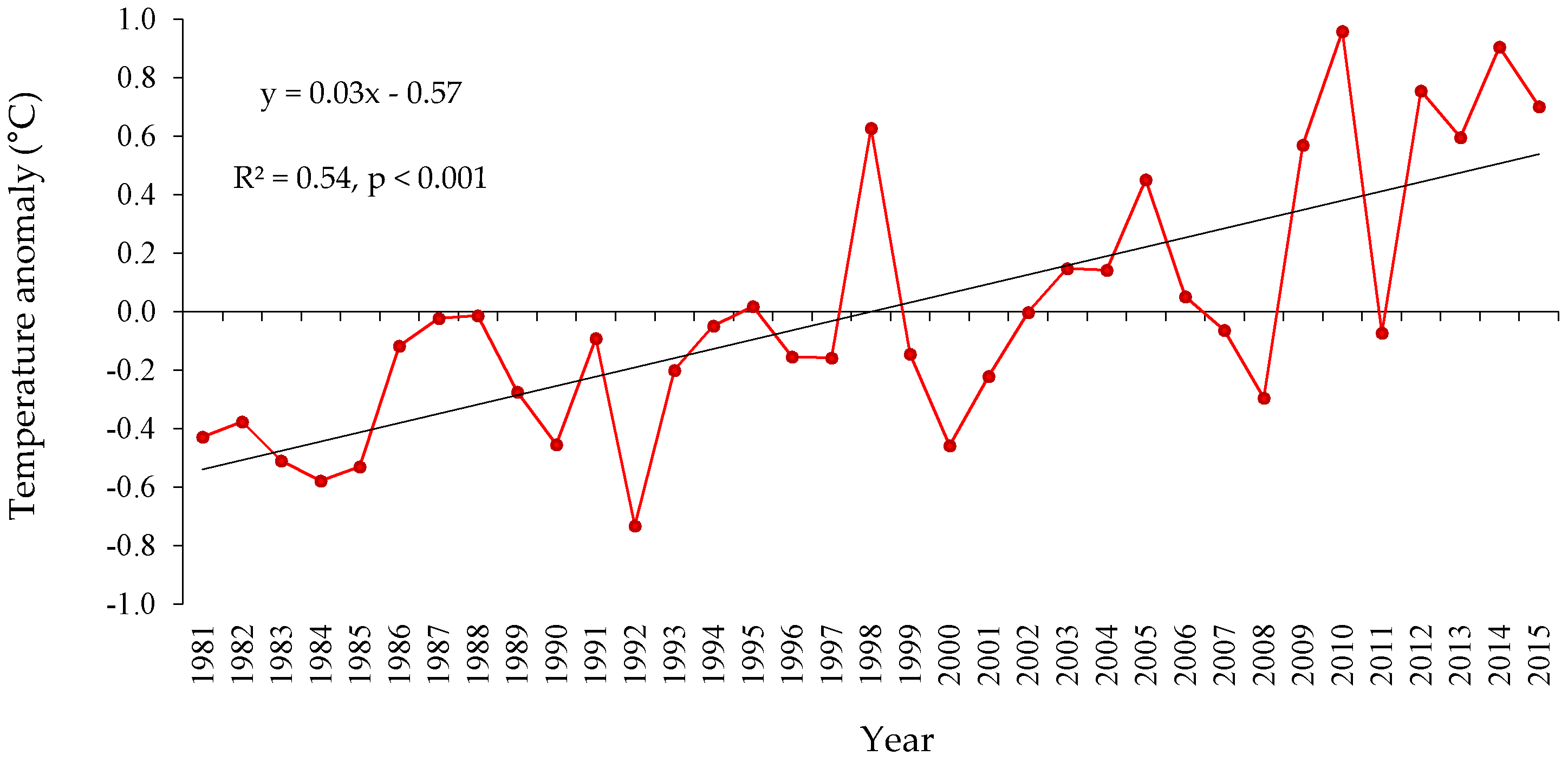
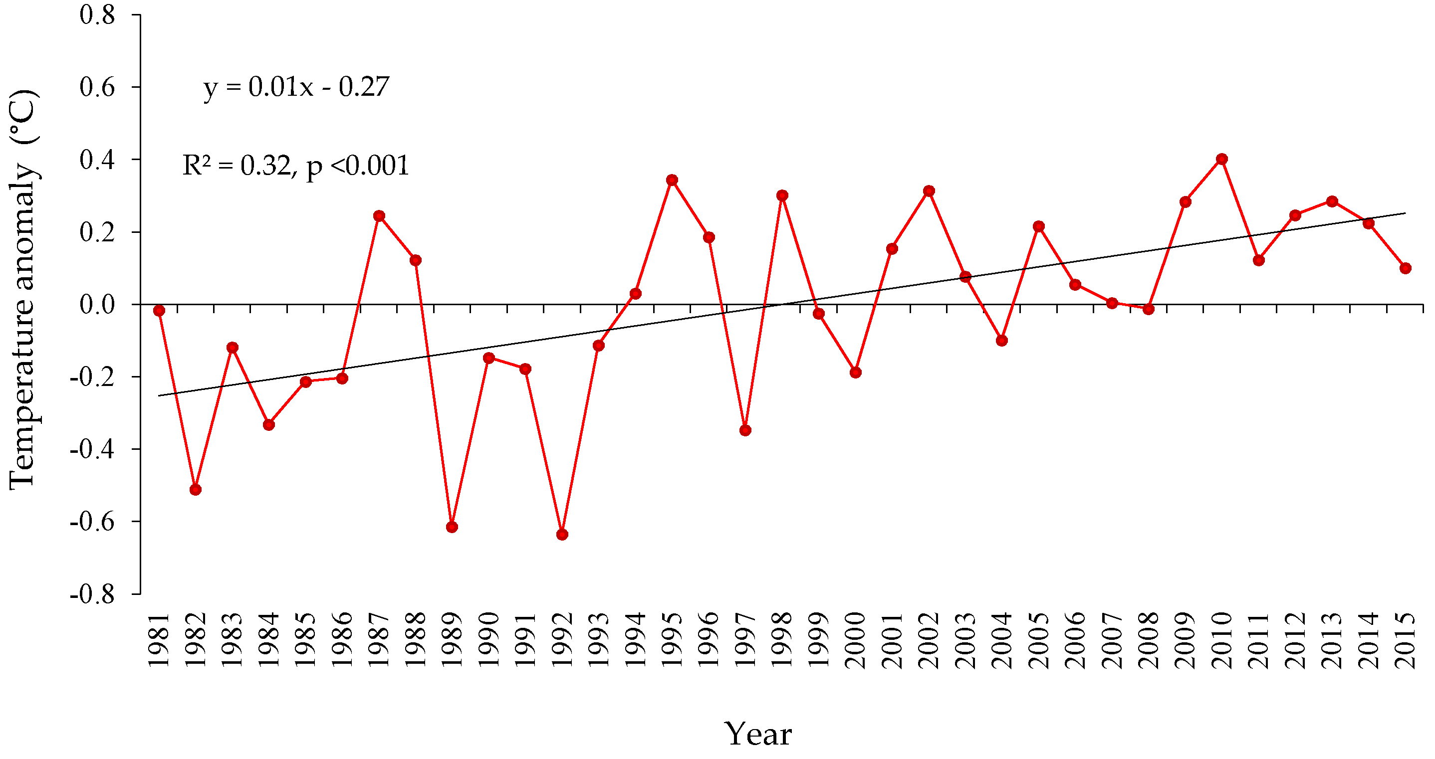
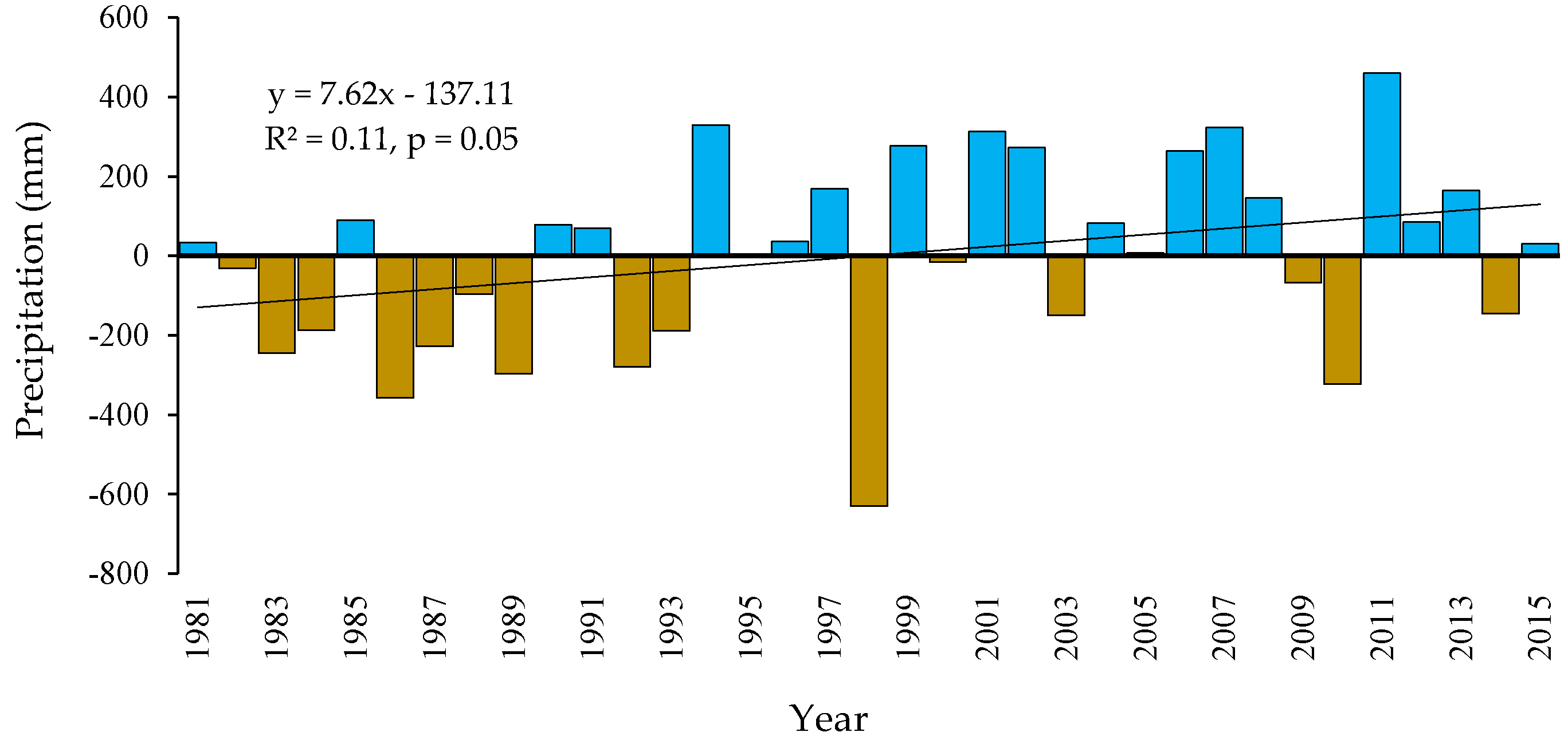
3.1. Temperature and Precipitation Anomaly

Figure 2 shows the maximum temperature anomalies during the period of 1981–2015 versus the average (mean) value with the same period. The trend of mean maximum temperature anomalies indicates a significant (p ≤ 0.05) upward warming of 0.32 °C/decade. The highest increasing range was observed in 2010 with +1.0 °C. The trend line in Figure 2 also indicates that the periods of 1990s was relatively cool while 2010s was relatively warm. The significant positive anomalies with greater than 0.5 °C were detected during 2009 to 2015 for all years except 2011. During the 35-year study period, the highest mean maximum temperature was found in 2010 (+1.0 °C) followed by 2014 (+0.9 °C) and 2012 (+0.8 °C). On the other hand, the lowest anomaly was observed in 1992 with −0.7 °C.
The mean minimum temperature anomalies in Myanmar indicate the positive trend and leads to warming periods since 1990s (Figure 3). The warming periods started from 1994 but fluctuated greatly between positive and negative anomalies. The warming ranges between a minimum of +0.01 °C (2007) to a maximum of +0.40 °C (2010) with the slope of 0.15 °C/decade. The continuous positive anomalies were identified after 1993 except 1997, 2000, and 2004, which were below the average. The minimum temperature shows a significantly decreasing trends with the highest range in 1992 (−0.6 °C), 1989 (−0.6 °C), and 1982 (−0.5 °C), respectively. Moreover, both mean maximum and minimum temperatures were detected with the highest anomaly in 2010 and lowest in 1992 (Figure 2 and Figure 3).
Figure 4 illustrates the annual total precipitation anomalies across Myanmar. Precipitation anomalies are characterized by fluctuations with positive and negative anomalies. In the trend line, we can observe that after 1998, the precipitation trend is positively increased but reversely before 1998. By comparing before and after 1998, the amounts of precipitation were increased more than 100 mm above normal. The highest precipitation amount was found in 2011 with 460 mm above the average. On the other hand, the lowest precipitation occurred in 1998 with 630 mm, and 2010 with 322 mm below average. According to the precipitation trends, it can be identified that the year 2010 is driest and 2011 is wettest during the most recent decade (Figure 4).

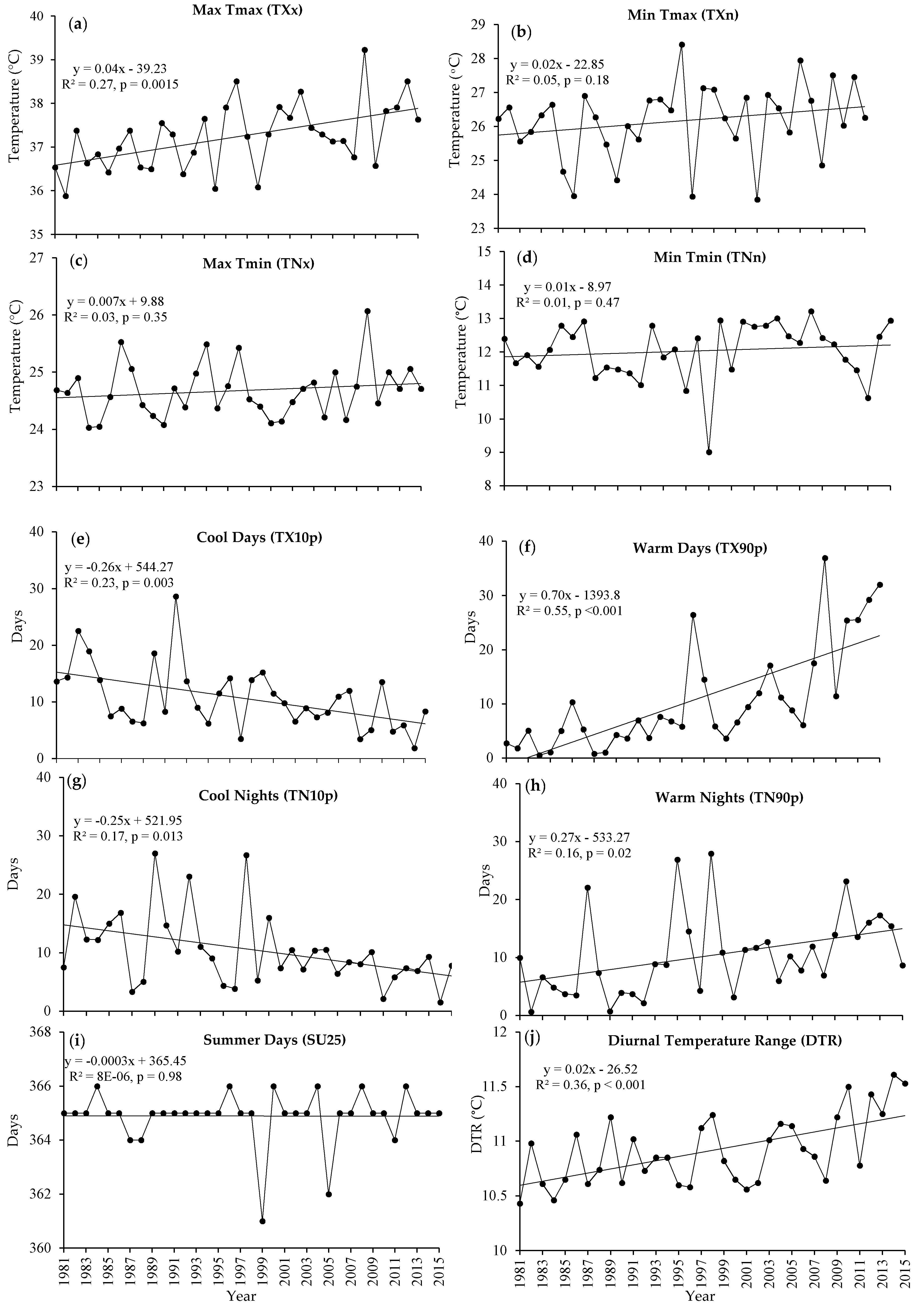
3.2. Temperature and Precipitation Extreme Indices

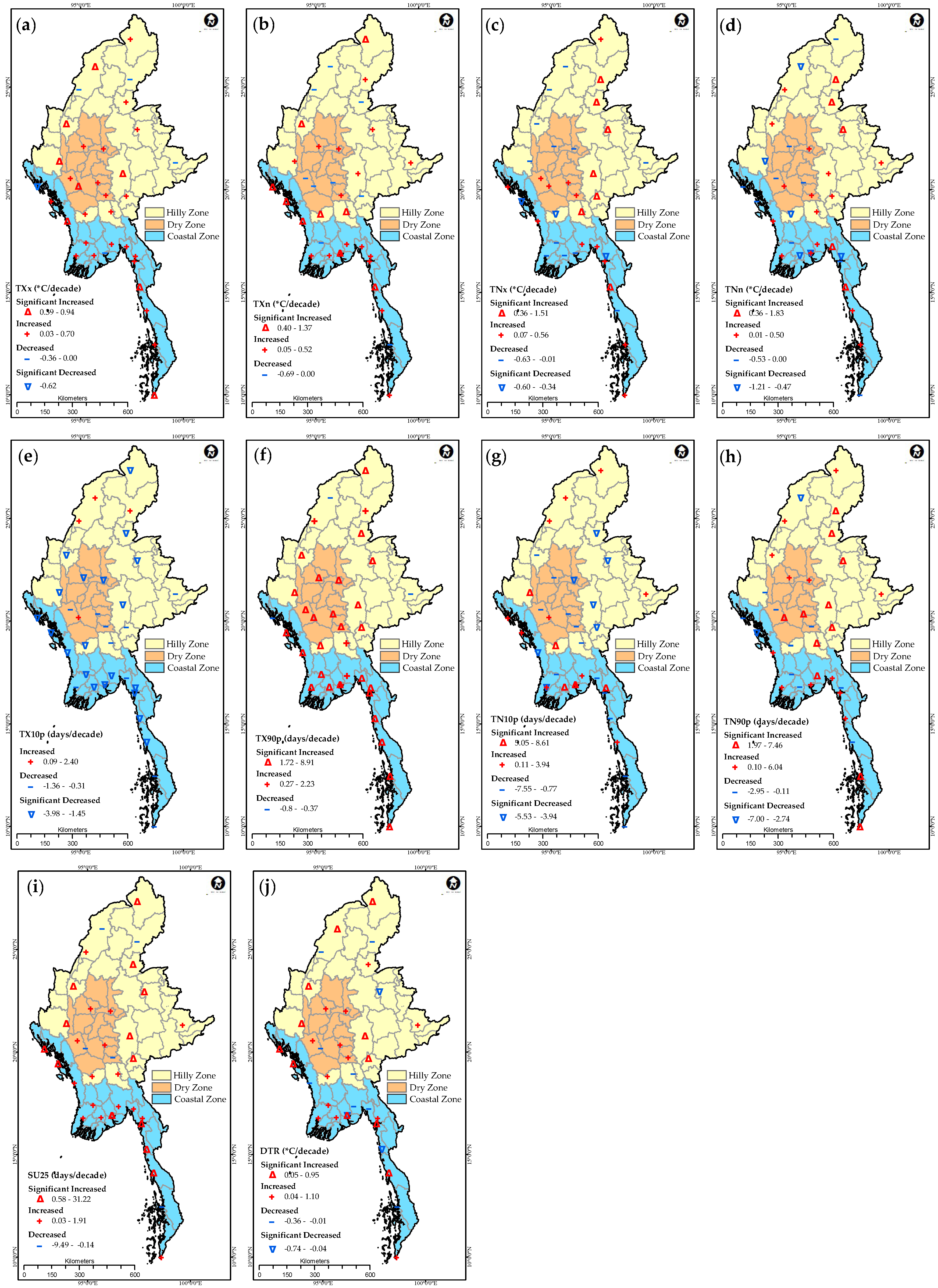
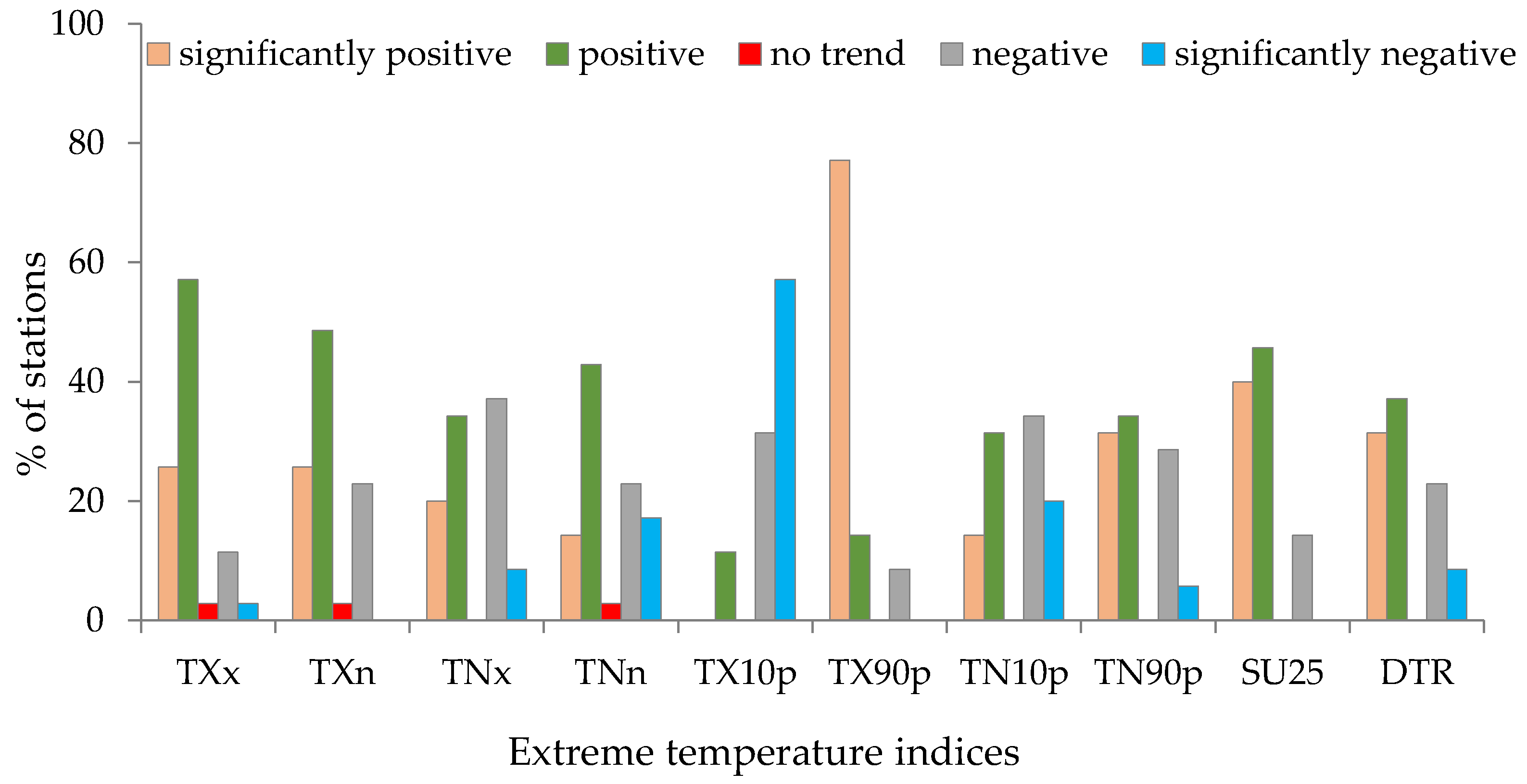
3.2.1. Temperature Extreme Indices

The Max Tmax (TXx) values show significant increase, while Min Tmax (TXn), Max Tmin (TNx), and Min Tmin (TNn) indicate only a slightly positive trend (Figure 5a–d). The averages of temperature indices, TXx, TXn, TNx, and TNn have increased by 0.38 °C/decade, 0.25 °C/decade, 0.07 °C/decade, and 0.11 °C/decade, respectively. All the temperature extreme absolute value indices, TXx, TXn, TNx, and TNn have also shown increasing trends at most of the stations and some of them are significant (Figure 6a–d). Majority (83%) of the stations are with positive trends of TXx, 23% of these are statistically significant. The similar trend of TXn index shows 74% of the stations with increasing trends and with 26% of those are significant (Figure 6b). 54% of stations for TNx (Figure 6c) and 57% of stations for TNn indicate increasing trends. Only the station Kawthoung that no trend was observed (Figure 6d). The stations that are located in the high elevation (Bhamo, Lashio, Loikaw, Myitkyina, Taunggyi, Tangoo) and one station in coastal area (Ye stations) observed significant increases in nighttime temperature. It could possibly be influenced by means of less vegetation, cloudiness, and urbanization. The increasing range of daytime temperature indices (TXx, TXn) is higher than nighttime temperature indices (TNx, TNn) in most of the stations in Myanmar.
Over 1981–2015, the regional average of warm days (TX90p) and warm nights (TN90p) have increased since the end of the 1990s (Figure 5f,g). Cool days (TX10p) and cool nights (TN90p) showed similar pattern with significantly negative trends since 1990s (Figure 5e,g). The trends of warm days (TX90p) and warm nights (TN90p) were upward with the slope of 7.03 days/decade and 2.73 days/decade, respectively. On the other hand, significantly decreased in cool days (TX10p) and cool nights (TN10p) by −2.67 days/decade, and −2.56 days/decade were observed. The frequency of percentile based indices, TX90p and TN90p show significant warming trends over the study area (Figure 6f,g). Overall, 32 (91%) out of 35 stations except three stations (Hkamti, Kengtung, and Sittwe) show positive trends, those of 27 (77%) stations are significant increases in warm days (TX90p) (Figure 6f). For the warm nights (TN90p), 65% of stations show positive trends with half of them are statistically significant (Figure 6g). Stations that located in the central and southern parts of Myanmar mainly observed an increase in warm days significantly (Figure 6f). However, the majority of significant increases in warm nights were observed mostly in central, northern, and eastern part of Myanmar (Figure 6h).
The annual trends of both cool days (TX10p) and cool nights (TN10p) were decreased during the study periods 1981–2015 (Figure 5e,g). Three stations (Hkamti, Homalin, Myitkyina) in northern region, and one station (Minbu) in central region were increased in cool days because of higher elevation, but their ranges are not significant (Figure 6e). Most of the stations in the southern part of Myanmar are statistically significantly decreased (Figure 6e). More than half of the stations show decreasing trends in cool nights (55% of stations) with statistical significance in the eastern part of Myanmar (Figure 6g). All the stations in central region show both significant increases in warm days and decreases in cool nights (Figure 6f,g).
The average of annual count of summer days (SU25) remained constant (Figure 5i) but the positive trends in specific stations were observed (Figure 6i). The annual count of summer days (SU25) was increased at 30 stations (significant at 14 stations), but the decrease in SU25 was found at five stations (Hkamti, Minbu, Myeik, Myitkyina, Pyinmana) (Figure 6i). This evidence suggests an increase in the annual number of days when maximum surface air temperature was higher than 25 °C at most stations across Myanmar. The diurnal temperature range (DTR) shows significant upward trends in the region with the range of +0.2 °C/decade (Figure 5j). Spatially, DTR increased at 24 out of 35 stations (significance at 11 stations), and decreased at 11 stations in mountain range and southern region (Figure 6j). The percentage of stations with significantly positive, positive, no trend, negative, and significantly negative for each temperature indices are shown in Figure 7 and Table S1.

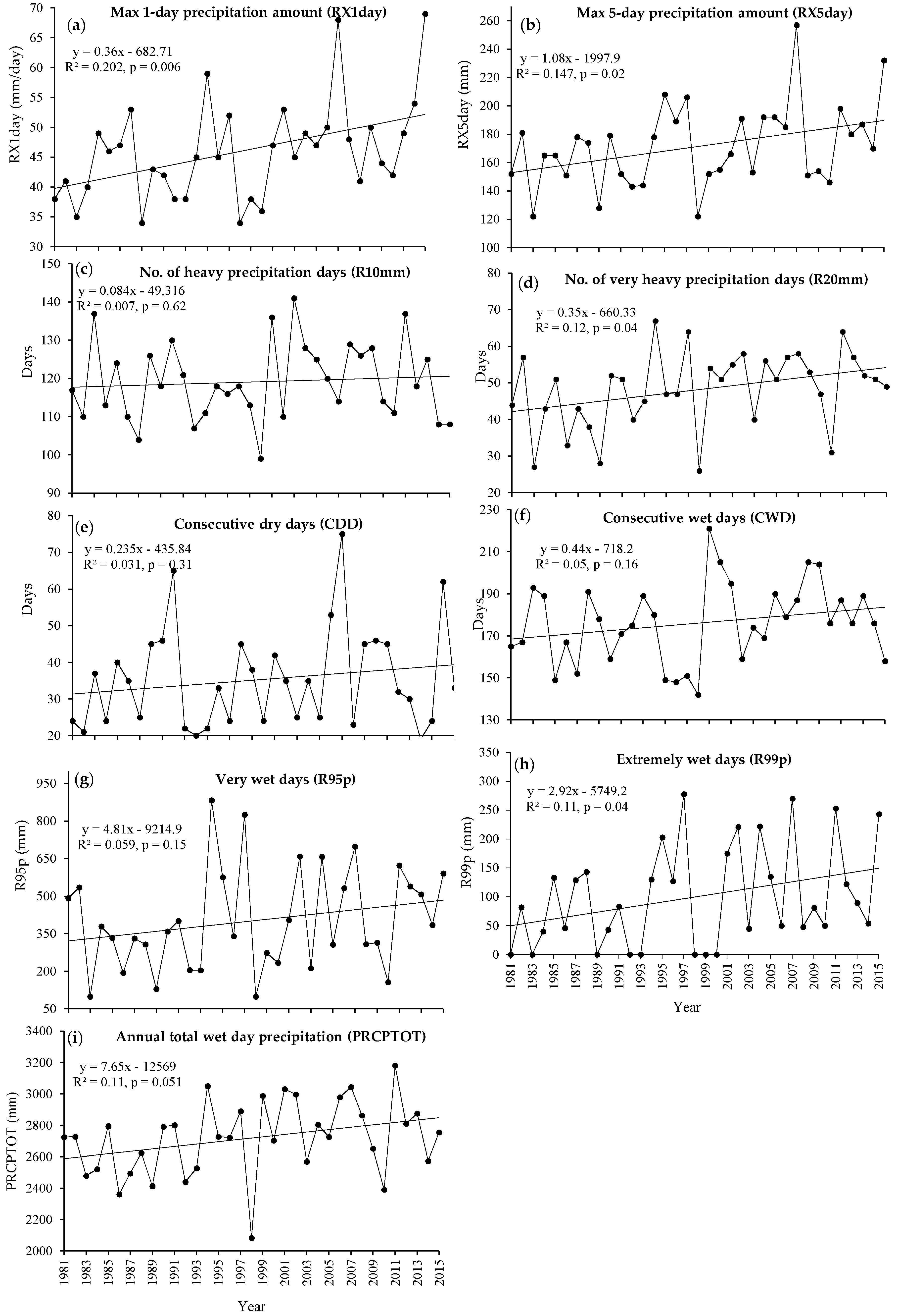
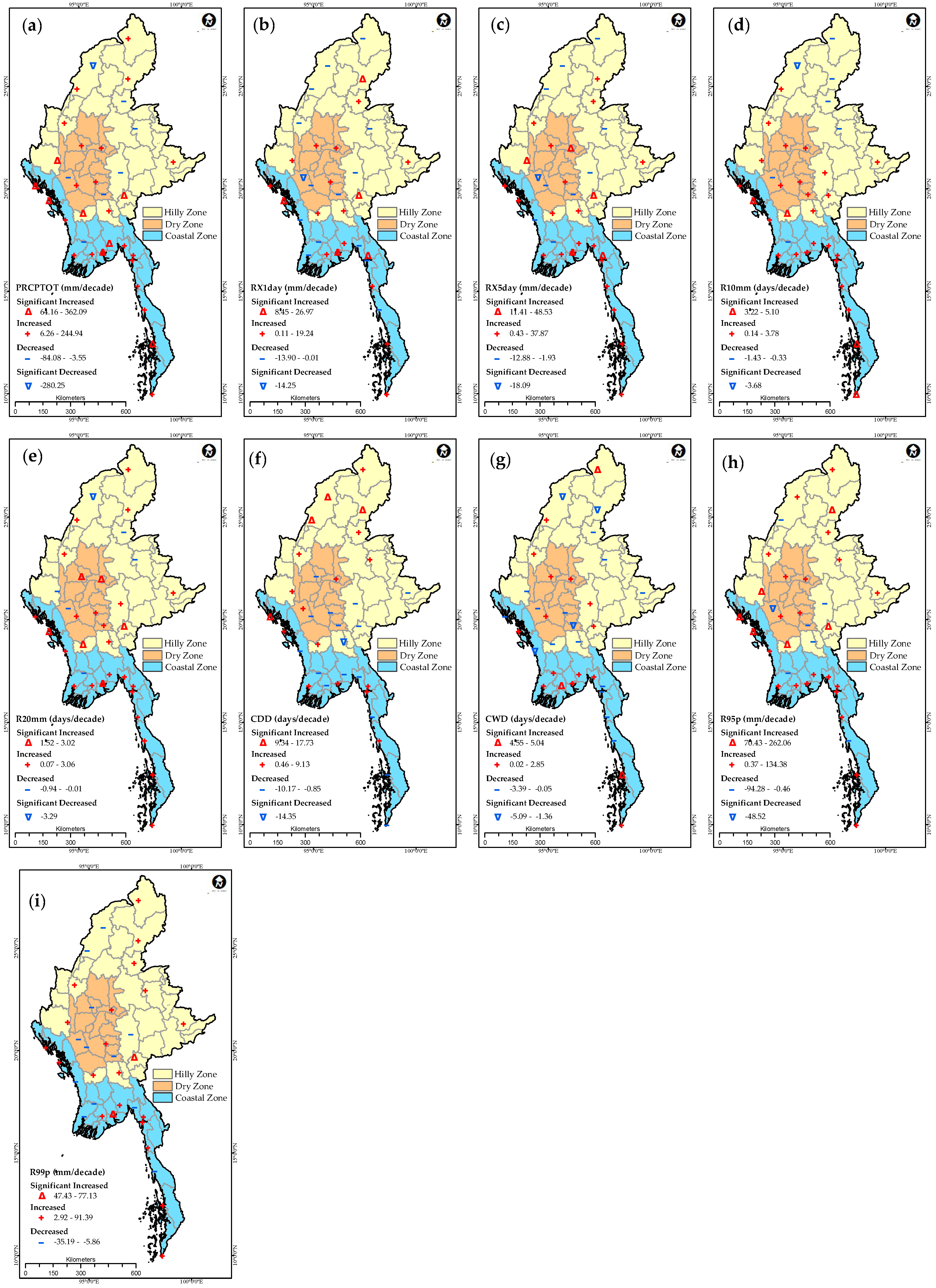
3.2.2. Precipitation Extreme Indices

The changes in precipitation extreme indices during 1981–2015 are less obvious than that of the temperature extremes. The regional average of maximum one-day precipitation (RX1day), maximum five-day precipitation amount (RX5day), and annual total wet day precipitation (PRCPTOT) have been increasing at the rates of 36.5 mm/decade, 10.8 mm/decade, and 76.5 mm/decade respectively (Figure 8a,b,i). Absolute precipitation indices show increasing trends at 57% of the stations (significant at 14%) for RX1day, and 71% (significant at 14%) for RX5day (Figure 9b,c). For PRCPTOT, 80% of the stations have positive trends with 23% of those are statistically significant (Figure 9a). The southern part of Myanmar (coastal region) is dominated by positive trends in both PRCPTOT, and RX5day (Figure 9a,c).
The number of days with precipitation ≥10 mm (R10mm) and ≥20 mm (R20mm) are indicators of heavy precipitation and very heavy precipitation days. Although, very heavy precipitation indices (R20mm) show increasing pattern, slightly decrease in heavy precipitation indices (R10mm) was also observed (Figure 8c,d). The increase of regional average values of R10mm, and R20mm are 0.84 and 3.54 days/decade, respectively. For R10 mm, 28 (80%) out of 35 stations show positive trends in heavy precipitation days while 29 (83%) out of 35 stations in very heavy precipitation days. The majority of stations with increasing heavy and very heavy precipitation days were observed in central and coastal region of Myanmar (Figure 9d,e).
The annual maximum number of consecutive dry days (CDD) is an index to measure extremes of low precipitation, and the maximum number of consecutive wet days (CWD) is to measure intense precipitation. Across Myanmar, CDD and CWD have not significantly increased during 1981–2015 (Figure 8e,f). More than 50% of stations with decreasing continuous wet days were observed for the majority of the stations in northern, eastern, central regions. Significant increases in CDD and decreases in CWD were observed in the northern part of Myanmar (Figure 9f,g).
The heavy rainfall events, very wet days precipitation (R95p), and extreme heavy rainfall events, extreme wet days precipitation (R99p), are generally rising. The increase of 48.1 mm/decade in R95p and 29.3 mm/decade in R99p are observed across Myanmar (Figure 8g,h). Spatially, the index of R95p was increased at 80% of stations (17% with significant) in a mountain range and coastal region (Figure 9h). Similarly, R99p presented 63% of stations with positive and 9% of those are statistically significant (Figure 9i) with larger values at the stations in coastal region. All percentile-based precipitation indices, absolute precipitation indices, and threshold precipitation indices generally show a slight increase across Myanmar. However, spatially, the majority of the stations in coastal region have been found with significant increases in precipitation indices. On the other hand, the majority of the stations with less precipitation amount were observed in the northern region. The percentage of stations with significantly positive, positive, no trend, negative, significantly negative for each precipitation indices are shown in Figure 10 and Table S2.

4. Discussion

Myanmar is one of the most vulnerable countries with regards to the impacts of climate change and variability [16]. However, comprehensive investigation of the characteristics and changes of relevant extreme climate in Myanmar is lacking. This study could be regarded as the first comprehensive compilation of meteorological records and analysis of extreme climate indices across the country. As indicated by various temperature and precipitation indices, our results reveal that increasing temperature is found across Myanmar. The country is also facing with climate extremes and the frequency and magnitude of these climate extremes differ from regions to regions.
During the period 1981–2015, this study found a significant positive trend of minimum and maximum temperature anomalies across Myanmar. The larger increase observed in both maximum and minimum temperature after 2000 suggests that overall days and nights are becoming hotter for entire Myanmar over this recent period. Our study further indicates that increasing temperature rate was as high as 0.32 °C/decade during 1981–2015. Moreover, the significant warmest (p < 0.01) years which exceed +0.5 °C higher than normal, such as 1998, 2005, 2009, 2010, 2012, 2013, 2014, and 2015 were notable and consistent with the 12 warmest years based on the NOAA dataset [33]. In addition, a previous study also reported that the mean temperature increased 0.08 °C/decade during 1961–2000 [34]. Thus, it could be said that the temperature were increased in both periods. These continuous warming trends in recent decades are probably resulted from anthropogenic induced warming due to increases in greenhouse gas emissions to the atmosphere [35].
The year 1998 was highest and 1992 was lowest anomalies in temperature during the 1990s, agreeing with previous results done by Trenberth et al. [36] and Cinco et al. [37]. The year 1998 was coincided with one of the warmest years in the last century based on instrumental records of surface temperatures from three major climatic monitoring organizations around the world [36,37,38]. On the other hand, significant decrease in the temperature in 1992 could be associated with the effect of the 1991 Mount Pinatubo volcanic eruption [37].
Both mean maximum and minimum temperatures in recent decades continued to significantly increase, with the highest anomaly in 2010. According to a national report, in 2010 severe drought diminished village water sources across the country and noticeable recorded by El Niño event in Myanmar [34]. Similar findings on the effects of the El Niño event in 2010 were also reported in other regions such as Southeast Asia and South Pacific region, Indo-Pacific region, and Asia-Pacific region, and on a global scale [1,9,39].
All the temperature extreme indices of absolute value, percentile-based, and threshold indices have shown increasing trends at most of the stations and some of them are significant. Our analysis reveals that the frequency of warm days and warm nights has increased, and the frequency of cool days and cool nights has decreased at most of stations in Myanmar. Moreover, we observed that the ranges of maximum temperature changes are wider than that of the minimum temperature at most of the stations in Myanmar. However, many studies found that minimum temperatures have increased at higher rates than that of the maximum temperature (e.g., [7,9,36,40,41]). Furthermore, we found the relatively large fractions of the stations (68%) have recorded an increase in the trend of DTR range. This is also another characteristic for Myanmar that is different from many other regions. DTR shows decreasing trends in Asia-Pacific Network countries, Indo Pacific regions, China, South Asia, and Tibetan Plateau [9,11,42,43]. The discrepancy could be stem from the different analysis period of our study and their study. Compiling the dataset from various regions using the same time period therefore could help explain this difference.
In terms of temperature extreme indices, our results indicate that warm extreme indices were occurred more frequently than cool extreme indices. These are consistent with the scenarios from climate model simulations driven by increasing greenhouse gas levels [7]. In addition, our findings show the temperature extreme indices have been increasing statistically significantly over Myanmar, while cool nights and days are decreasing.
Over 1981–2015, although increasing trends in precipitation anomaly are not statistically significant across Myanmar, we still found that precipitation slightly increased and was shifted towards wetter conditions in general, and agreed with those reported for regional and global trends [4,5,6,9,11]. The slightly wet years with greater than 200 mm above normal were detected in 1994, 1999, 2001, 2002, 2006, 2007, and 2011. The rest of the years were observed as dry years with the lowest precipitation amount in 1998 and 2010. It can be concluded that the 1990s was the dry period and 2000s was the wet period in Myanmar.
The analysis results show that increases in both frequency and intensity of extreme precipitation is less spatial coherence across the region and fewer trends that are locally significant when compared with the temperature extreme. Across Myanmar, we found that numbers of stations with increasing trends in all the precipitation extremes indices are larger than those with decreasing trends. Overall, the stations located in coastal region show the significant increasing trends in extreme precipitation events. The results could be the influence of cyclonic storms, and depression in the Bay of Bengal and these usually resource towards coastal area [16]. Generally, our findings of increasing trends in precipitation extremes are consistent with the other previous studies of regional and global analysis. However, it does not correspond well with what has been observed in Southeast Asia region, including Myanmar e.g., [10]. Endo et al. [10] found that annual total precipitation was declined in most of the stations and heavy precipitation increases in northern part of Myanmar. These are different from our findings of slightly increasing annual total precipitation. These may be due to the fact that their analysis was based on the different time period (1961–1970).
It is well-known that the summer monsoon season from June to September is the principal rainy season in Myanmar in which period about 75–90% of the total annual precipitation is received [44]. However, Sen Roy and Kaur [44] observed that the southern parts of the country start receiving rain in monsoon onset (mid-May) and there is some rain in October as well. The observed precipitation pattern is associated with the Intertropical Convergence Zone (ITCZ) moves northward, bringing rains to Myanmar as monsoon onset. The irregular changes in the summer monsoon moisture transport can lead to significant changes in rainfall over Myanmar [45]. Sein et al. [45] stated that the entire country is generally characterized by south westerlies regardless of the years, wet or dry. The southern parts of the country are characterized by convergence in the low levels while the northern is characterized by divergence. Their finding is in agreement with our results on the highest rate of precipitation extreme indices over coastal regions. Moreover, they found that the country is characterized by positive moisture transport anomaly depicting convergence over the entire country during the wet years (e.g., 2001) while almost entire country is characterized by low level divergence during dry years (e.g., 1972). Our study on annual total precipitation anomalies greater than 313 mm above normal in the year 2001 (Figure 4) is well in agreement with their finding on the characteristics of the positive moisture transport anomaly depicting convergence over the entire country.
In order to understand more about the factors that influence the trends in climate and their anomalies over Myanmar, El Niño (warm) and La Niña (cool) years defined by Oceanic Niño Index (ONI) were compared. These data sets for the years 1981–2015 are collected from the National Oceanographic and Atmospheric Administration (NOAA) [46]. For example, some years of PRCPTOT (Figure 8i) were linked to La Niña (Figure 11a) like 1999, 2001, 2008, and 2011. Similarly, in the case of El Niño (Figure 11a), the year 1987, 1995, 1998, and 2010 were also linked to PRCPTOT (Figure 8i). Similarly, the correlation patterns between SSTs and some indices related to heavy precipitation and very heavy precipitation (R10mm, R20mm) indicate a close link to ENSO pattern (Figure 8c,d), for instance, in 1999, 2001, 2008, and 2011. As we discussed in Section 3.2.2, PRCPTOT results confirm that 2010 is driest and 2011 is wettest within the most recent decade. Negative SST anomalies in the equatorial Pacific (La Niña conditions) are correlated with increased heavy precipitation days [11].
Moreover, if we link to TN90p and SSTs, we can be seen that some years of TN90p (Figure 5h) were linked to SSTs (Figure 11b) like 1987, 1989, 1995, 1998, etc. However, not all the extreme indices follow El Niño and La Niña events because locally specific impact differs from place to place based on the local SSTs. Thus, the regional and global phenomena such as ENSO have effectively reflected in local records in Myanmar. Our result is followed to the statement of Caesar et al. (2011) that the frequency of warm nights and local SSTs have positive relationships [11].

5. Conclusions

This study analyzes changes in observed temperature and precipitation extreme indices using daily maximum and minimum temperature during 1981 to 2015 for 35 stations in Myanmar. The key findings can be summarized as follows:
-
Maximum temperature increasing rate is 0.38 °C/decade and this is higher than previous studies;
-
Continuous warming trend in maximum temperature exceed +0.5 °C than normal were observed from 2009 to 2015 for all years except 2011;
-
The overall rate of increase in maximum temperature is higher than that of the minimum temperature;
-
Warm extreme indices are more frequent than cool extreme indices;
-
Highest rate of increase temperature extreme indices was observed in the central region compared to the other regions;
-
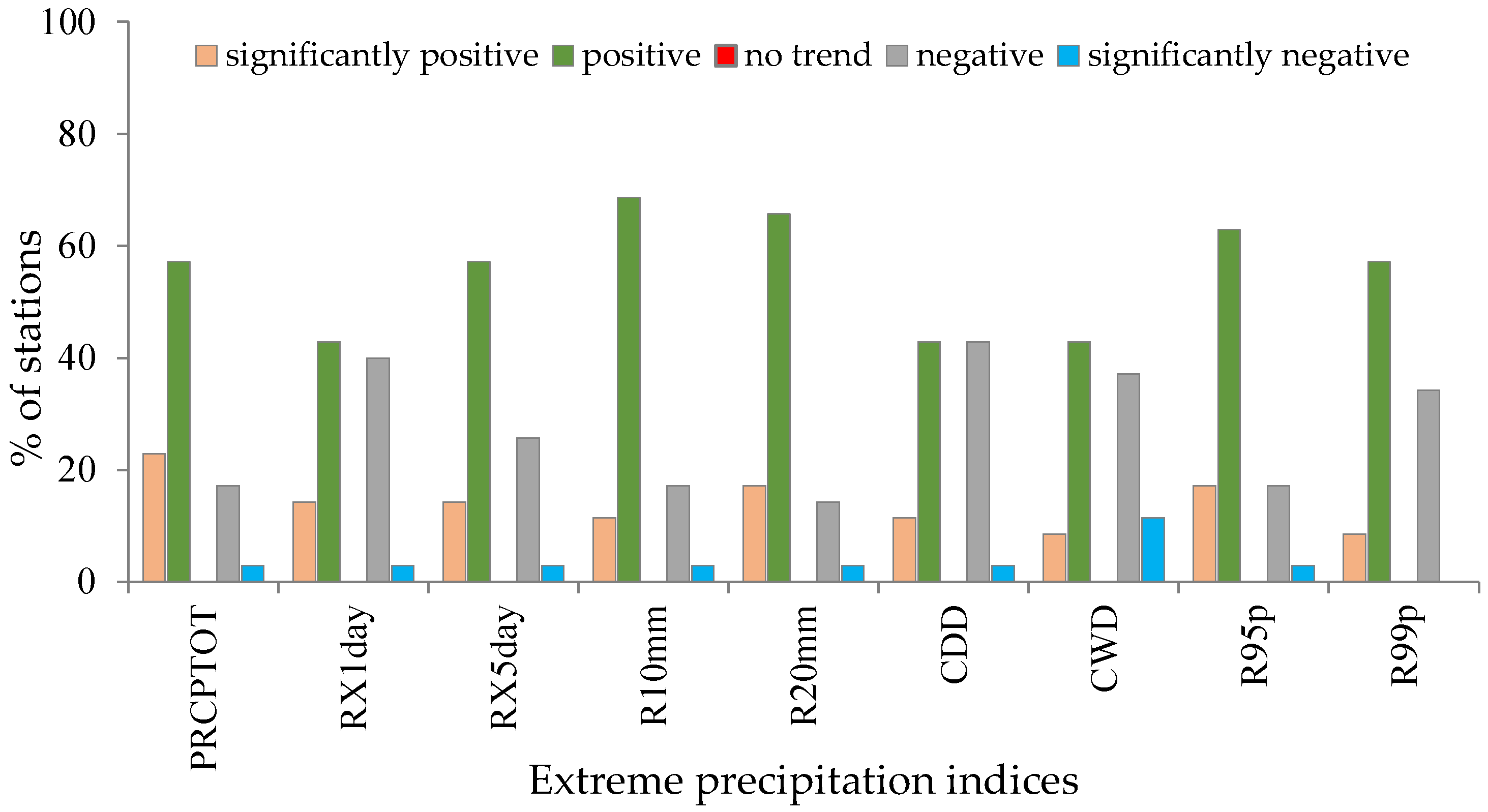
Precipitation trends have been towards wetter conditions with more very heavy precipitation days since 1999;
-
Highest rate of precipitation extreme indices were detected in coastal region;
-
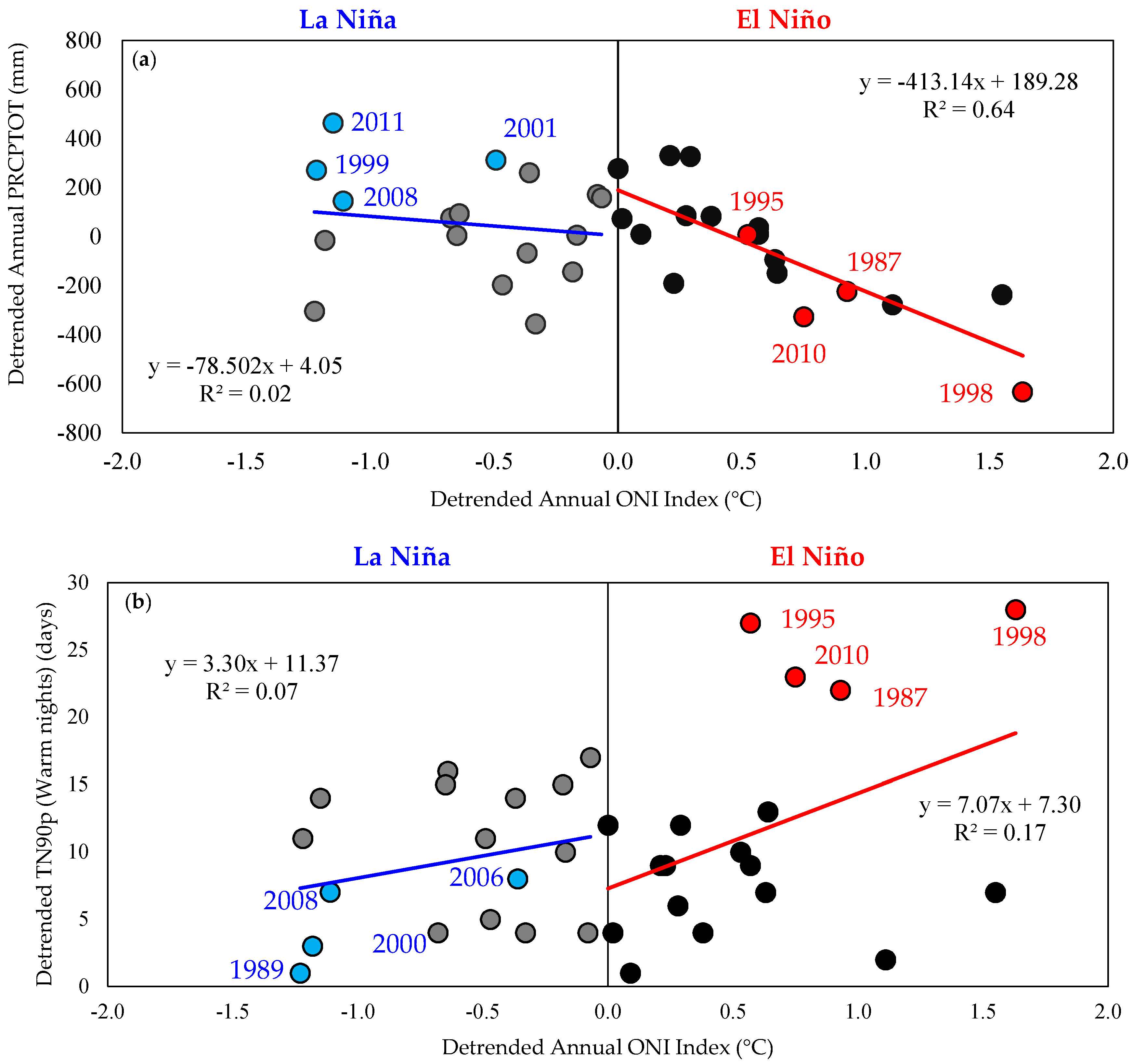
There is a strong link between ENSO and PRCPTOT in Myanmar.
Across Myanmar, central region and coastal region should be more aware in terms of climate extreme impacts. If the temperature in Myanmar continues with the increasing trend, there could be the possibility of more frequent extreme weather events—such as heat wave, drought, extreme precipitation, flooding, landslide, etc.—which create serious impacts on ecosystems, and socio-economic conditions in this area. It is hoped that this study could be the basis of evidence for appropriate action to address and prepare for future evaluation of climate impacts and for finding out the appropriate measures for adaptive capacity enhancement.

Supplementary Materials

The following are available online at https://www.mdpi.com/2073-4433/9/12/477/s1, Table S1: Trends per decade in temperature indices for the period 1981–2015, Table S2: Trends per decade precipitation indices for the period 1981–2015.

Author Contributions

All authors contributed to the research and designed methodology of this study and to the collaboration of this manuscript. K.K.S. performed the data collection and analysis, and prepared the first draft of this paper. K.L.O. participated in the discussion and provided useful comments. A.C. supervised the overall research work, provided guidelines for the write up of the manuscript, and contributed to its editing and finalization.

Funding

This research was funded by the United States Agency for International Development (USAID) and the National Science Foundation under the Partnership for Enhanced Engagement in Research (PEER) program (grant number PGA-2000003836). This study is part of a project entitled “Analysis of Historic Forest Carbon Changes in Myanmar and Thailand and the Contribution of Climate Variability and Extreme Weather Events”.

Acknowledgments

We are grateful to Sirintornthep Towprayoon of JGSEE, Monique LeClerc and Merryl Alber of the University of Georgia for suggestions and generous support, and to the Department of Meteorology and Hydrology (DMH), Nay Pyi Taw, Myanmar for providing long-term historical climate data.

Conflicts of Interest

The authors declare no conflict of interest.

References

  1. IPCC Climate Change 2013: The Physical Science Basis. Contribution of Working Group to the Fifth Assessment Report of the Intergovernmental Panel on Climate Change; Cambridge University Press: Cambridge, UK, 2013.
  2. IPCC Climate Change 2007: The Physical Science Basis. Contribution of Working Group I to the Fourth Assessment Report of the Intergovernmental Panel on Climate Change; Cambridge University Press: Cambridge, UK, 2007.
  3. Easterling, D.R.; Horton, B.; Jones, P.D.; Peterson, T.C.; Karl, T.R.; Parker, D.E.; Salinger, M.J.; Razuvayev, V.; Plummer, N.; Jamason, P.; et al. Maximum and minimum temperature trends for the Globe. Science 1997, 277, 364–367. [Google Scholar] [CrossRef]
  4. Kiktev, D.; Sexton, D.M.H.; Alexander, L.; Folland, C.K. Comparison of modeled and observed trends in indices of daily climate extremes. J. Clim. 2003, 16, 3560–3571. [Google Scholar] [CrossRef]
  5. Alexander, L.V.; Zhang, X.; Peterson, T.C.; Caesar, J.; Gleason, B.; Klein, T.A.M.G.; Haylock, M.; Collins, D.; Trewin, B.; Rahimzadeh, F.; et al. Global observed changes in daily climate extremes of temperature and precipitation. J. Geophys. Res. 2006, 111, D05109. [Google Scholar] [CrossRef]
  6. Donat, M.G.; Alexander, L.V.; Yang, H.; Durre, I.; Vose, R.; Dunn, R.J.H.; Willett, K.M.; Aguilar, E.; Brunet, M.; Caesar, J.; et al. Updated analyses of temperature and precipitation extreme indices since the beginning of the twentieth century: The HadEX2 dataset. J. Geophys. Res. 2013, 118, 2098–2118. [Google Scholar] [CrossRef] [Green Version]
  7. Manton, M.J.; Della-Marta, P.M.; Haylock, M.R.; Hennessy, K.J.; Nicholls, N.; Chambers, L.E.; Yee, D. Trends in extreme daily rainfall and temperature in Southeast Asia and the south Pacific: 1961–1998. Int. J. Climatol. 2001, 21, 269–284. [Google Scholar] [CrossRef]
  8. Griffiths, G.M.; Chambers, L.E.; Haylock, M.R.; Manton, M.J.; Nicholls, N.; Baek, H.J.; Zhai, P. Change in mean temperature as a predictor of extreme temperature change in the Asia-Pacific region. Int. J. Climatol. 2005, 25, 1301–1330. [Google Scholar] [CrossRef] [Green Version]
  9. Choi, G.; Collins, D.; Ren, G.; Trewin, B.; Baldi, M.; Fukuda, Y.; Zhou, Y. Changes in means and extreme events of temperature and precipitation in the Asia-Pacific Network region, 1955-2007. Int. J. Climatol. 2009, 29, 1906–1925. [Google Scholar] [CrossRef] [Green Version]
  10. Endo, N.; Matsumoto, J.; Lwin, T. Trends in precipitation extremes over Southeast Asia. SOLA 2009, 5, 168–171. [Google Scholar] [CrossRef]
  11. Caesar, J.; Alexander, L.V.; Trewin, B.; Tsering, K.; Sorany, L.; Vuniyayawa, V.; Sirabaha, S. Changes in temperature and precipitation extremes over the Indo-Pacific region from 1971 to 2005. Int. J. Climatol. 2011, 31, 791–801. [Google Scholar] [CrossRef] [Green Version]
  12. Yazid, M.; Humphries, U. Regional observed trends in daily rainfall indices of extremes over the Indochina Peninsula from 1960 to 2007. Climate 2015, 3, 168–192. [Google Scholar] [CrossRef]
  13. Almazroui, M.; Islam, M.N.; Dambul, R.; Jones, P.D. Trends of temperature extremes in Saudi Arabia. Int. J. Climatol. 2014, 34, 808–826. [Google Scholar] [CrossRef]
  14. Hoyos, C.D.; Webster, P.J. The role of intraseasonal variability in the nature of Asian monsoon precipitation. J. Clim. 2007, 20, 4402–4424. [Google Scholar] [CrossRef]
  15. Kreft, S.; Eckstein, D.; Melchior, I. Global Climate Risk Index 2017: Who Suffers Most from Extreme Weather Events? Weather-Related Loss Events in 2015 and 1996 to 2015; Germanwatch e.V.: Bonn, Germany, 2016; ISBN 978-3-943704-49-5. [Google Scholar]
  16. DMH. Myanmar Climate Report; Department of Meteorology and Hydrology (DMH), Ministry of Transport and Communications: Nay Pyi Taw, Myanmar, 2017.
  17. Eischeid, J.K.; Baker, C.B.B.; Karl, T.R.; Diaz, H.F. The Quality Control of Long-Term Climatological Data Using Objective Data Analysis. J. Appl. Meteorol. 1995, 34, 2787–2795. [Google Scholar] [CrossRef] [Green Version]
  18. Karl, T.R.; Tarpley, J.D.; Quayle, R.G.; Diaz, H.F.; Robinson, D.A.; Bradley, R.S. The recent climate record: What it can and cannot tell us. Rev. Geophys. 1989, 27, 405. [Google Scholar] [CrossRef] [Green Version]
  19. Aguilar, E.; Auer, I.; Brunet, M.; Peterson, T.C.; Wieringa, J. Guidelines on Climate Metadata and Homogenization; WMO-TD, No. 1186, WCDMP No. 53; World Meteorological Organization: Geneva, Switzerland, 2003; p. 55. [Google Scholar]
  20. Zhang, X.; Yang, F. RClimDex 1.0 User Manual; Climate Research Branch Environment Canada: Downsvies, ON, Canada, 10 September 2004; p. 22.
  21. Sharma, D.; Babel, M.S. Trends in extreme rainfall and temperature indices in the western Thailand. Int. J. Climatol. 2014, 34, 2393–2407. [Google Scholar] [CrossRef]
  22. You, Q.; Kang, S.; Aguilar, E.; Yan, Y. Changes in daily extremes in the eastern and central Tibetan Plateau during 1961–2005. J. Geophys. Res. Atm. 2008, 113, 1–17. [Google Scholar] [CrossRef]
  23. Shrestha, A.B.; Bajracharya, S.R.; Sharama, A.R.; Duo, C.; Kulkarni, A. Observed trends and changes in daily temperature and precipitation extremes over the Koshi river basin 1975–2010. Int. J. Climatol. 2016. [Google Scholar] [CrossRef]
  24. Wang, X.L.; Wen, Q.H.; Wu, Y. Penalized maximal t-test for detecting undocumented mean change in climate data series. J. Appl. Meteorol. 2006, 1–40. [Google Scholar] [CrossRef]
  25. Wang, X.L. Accounting for autocorrelation in detecting mean-shifts in climate data series using the penalized maximal t or F test. J. Appl. Meteorol. Climatol. 2008, 47, 2423–2444. [Google Scholar] [CrossRef]
  26. Wang, X.L. Penalized maximal F-test for detecting undocumented mean-shifts without trend change. J. Atmos. Ocean. Technol. 2008, 25, 368–384. [Google Scholar] [CrossRef]
  27. Wang, X.L.; Feng, Y. RHtestsV4 User Manual; Climate Research Division, Atmospheric Science and Technology Directorate, Science and Technology Branch, Environment Canada, July 2013; pp. 1–29. Available online: http://etccdi.pacificclimate.org/software.shtml (accessed on 15 November 2013).
  28. Vincent, L.A.; Peterson, T.C.; Barros, V.R.; Marino, M.B.; Rusticucci, M.; Carrasco, G.; Karoly, D. Observed trends in indices of daily temperature extremes in South America 1960–2000. J. Clim. 2005, 18, 5011–5023. [Google Scholar] [CrossRef]
  29. WMO. Guidelines on Analysis of Extremes in a Changing Climate in Support of Informed Decisions for Adaptation; WMO-TD No. 1500, WCDMP No. 72; World Meteorological Organization: Geneva, Switzerland, 2009; p. 52. [Google Scholar]
  30. Sen, P.K. Estimates of regression coefficient based on Kendall’s tau. J. Am. Stat. Assoc. 1968, 63, 1379–1389. [Google Scholar] [CrossRef]
  31. Mann, H.B. Non-parametric tests against trend. Econometrica 1945, 13, 245–259. [Google Scholar] [CrossRef]
  32. Kendall, M.G. Rank Correlation Methods; Charles Griffin: London, UK, 1975. [Google Scholar]
  33. NOAA. Global Climate Report—Annual 2016, National Centers for Environmental Information, National Oceanic and Atmospheric Administration. Available online: https://www.ncdc.noaa.gov/sotc/global/201613 (accessed on 10 June 2017).
  34. Myanmar’s National Adaptation Programme of Action (NAPA) to Climate Change. Available online: http://unfccc.int/resource/ docs/napa/mmr01.pdf (accessed on 13 July 2017).
  35. Hegerl, G.C.; Hoegh-Guldberg, O.; Casassa, G.; Hoerling, M.; Kovats, S.; Parmesan, C.; Pierce, P.; Stott, P. Good Practice Guidance Paper on Detection and Attribution Related to Anthropogenic Climate Change. In Meeting Report of the Intergovernmental Panel on Climate Change Expert Meeting on Detection and Attribution of Anthropogenic Climate Change; Stocker, T.F., Field, C.B., Qin, D., Barros, V., Plattner, G.-K., Tignor, M., Midgley, P.M., Ebi, K.L., Eds.; IPCC Working Group I Technical Support Unit, University of Bern: Bern, Switzerland, 2010. [Google Scholar]
  36. Trenberth, K.E.; Jones, P.D.; Ambenje, P.; Bojariu, R.; Easterling, D.; Tank, A.K.; Parker, D.; Rahimzadeh, F.; Renwick, J.A.; Rusticucci, M.; et al. Observations: Surface and Atmospheric Climate Change. In Climate Change 2007: The Physical Science Basis. Contribution of Working Group I to the Fourth Assessment Report of the Intergovernmental Panel on Climate Change; Cambridge University Press: Cambridge, UK; New York, NY, USA, 2007. [Google Scholar]
  37. Cinco, T.A.; de Guzman, R.G.; Hilario, F.D.; Wilson, D.M. Long-term trends and extremes in observed daily precipitation and near surface air temperature in the Philippines for the period 1951–2010. Atmos. Res. 2014, 145–146, 12–26. [Google Scholar] [CrossRef]
  38. Hansen, J.; Ruedy, R.; Sato, M.; Lo, K. Global surface temperature change. Rev. Geophys. 2010, 48, RG4004. [Google Scholar] [CrossRef]
  39. Christidis, N.; Stott, P.A.; Brown, S.; Hegerl, G.C.; Caesar, J. Detection of changes in temperature extremes during the second half of the 20th century. Geophys. Res. Lett. 2005, 32, 1–4. [Google Scholar] [CrossRef]
  40. Jones, P.D.; New, M.; Parker, D.E.; Martin, S.; Rigor, I.G. Surface air temperature and its changes over the past 150 years. Rev. Geophys. 1999, 37, 173–199. [Google Scholar] [CrossRef] [Green Version]
  41. Zhang, X.; Alexander, L.; Hegerl, G.C.; Jones, P.; Tank, A.K.; Peterson, T.C.; Trewin, B.; Zwiers, F.W. Indices for monitoring changes in extremes based on daily temperature and precipitation data. WIREs Clim Chang. 2011. [Google Scholar] [CrossRef]
  42. Qian, W.; Lin, X. Regional trends in recent temperature indices in China. Clim. Res. 2004, 27, 119–134. [Google Scholar] [CrossRef] [Green Version]
  43. Sheikh, M.M.; Manzoor, N.; Ashraf, J.; Adnan, M.; Collins, D.; Hameed, S.; Shrestha, M.L. Trends in extreme daily rainfall and temperature indices over South Asia. Int. J. Climatol. 2014. [Google Scholar] [CrossRef]
  44. Sen, R.N.; Kaur, S. Climatology of monsoon rains of Myanmar (Burma). Int. J. Climatol. 2000, 20, 913–928. [Google Scholar] [CrossRef] [Green Version]
  45. Sein, Z.M.M.; Ogwang, B.A.; Ongoma, V.; Ogou, F.K.; Batebana, K. Inter-annual variability of summer monsoon rainfall over Myanmar in relation to IOD and ENSO. J. Environ. Agric. Sci. 2015, 4, 28–36. [Google Scholar]
  46. NOAA. Historical El Niño and La Niña episodes (1950 to Present). National Centers for Environmental Information, National Oceanic and Atmospheric Administration. Available online: http://www.cpc.noaa.gov/products/analysis_monitoring/ensostuff/ ensoyears.shtml (accessed on 4 April 2017).
Figure 1. Map of Myanmar with locations of meteorological stations from which the data are used in the current study; (a) agro-ecological zone, and (b) elevation range (DMH, 2017).
Atmosphere 09 00477 g001
Figure 2. Observed annual maximum temperature anomalies in Myanmar during 1981–2015.
Atmosphere 09 00477 g002
Figure 3. Observed annual minimum temperature anomalies in Myanmar during 1981–2015.
Atmosphere 09 00477 g003
Figure 4. Observed annual total precipitation anomalies in Myanmar during 1981–2015.
Atmosphere 09 00477 g004
Figure 5. Annual trends of country-wide averaged temperature indices (a) TXx; (b) TXn; (c) TNx; (d) TNn; (e) TX10p; (f) TX90p; (g) TN10p; (h) TN90p; (i) SU25; and (j) DTR for the period 1981–2015.
Atmosphere 09 00477 g005
Figure 6. Spatial distribution of trends in extreme temperature indices (per decade) from 1981 to 2015 in Myanmar; (a) Max: Tmax (TXx); (b) Min: Tmax TXn; (c) Max: Tmin (TNx); (d) Min: Tmin (TNn); (e) Warm days (TX90p); (f) Warm nights (TN90p); (g) Cool days (TX10p); (h) Cool nights (TN10p); (i) Summer days (SU25); and (j) Diurnal temperature range (DTR). An increase is represented by ( Atmosphere 09 00477 i001) sign, a significant increase with ( Atmosphere 09 00477 i002), decrease with ( Atmosphere 09 00477 i003) sign, and significant decreases with ( Atmosphere 09 00477 i004) symbol.
Atmosphere 09 00477 g006
Figure 7. Percentage of all stations with significantly positive, positive, no trend, negative, significantly negative in extreme temperature indices.
Atmosphere 09 00477 g007
Figure 8. Annual trends of national averaged precipitation indices (a) RX1day; (b) RX5day; (c) R10mm; (d) R20mm; (e) CDD; (f) CWD; (g) R95p; and (h) R99p; and (i) PRCPTOT for the period 1981–2015.
Atmosphere 09 00477 g008
Figure 9. Spatial distribution of trends in extreme precipitation indices (per decade) from 1981 to 2015 in Myanmar; (a) PRCPTOT; (b) RX1day; (c) RX5day; (d) R10mm; (e) R20mm; (f) CDD; (g) CWD; (h) R95p; and (i) R99p. An increase is represented by ( Atmosphere 09 00477 i001) sign, a significant increase with ( Atmosphere 09 00477 i002), decrease with ( Atmosphere 09 00477 i003) sign, and significant decreases with ( Atmosphere 09 00477 i004) symbol.
Atmosphere 09 00477 g009
Figure 10. Percentage of all stations with significantly positive, positive, no trend, negative, and significantly negative in extreme precipitation indices.
Atmosphere 09 00477 g010
Figure 11. Comparison of NOAA Sea Surface Temperature Anomaly for Oceanic Nino Index Region 3.4 between (a) annual total precipitation (PRCPTOT), and (b) warm nights (TN90p). (https://climatedataguide.ucar.edu/climate-data/nino-sst-indices-nino-12-3-34-4-oni-and-tni).
Atmosphere 09 00477 g011
Table 1. Detail information of the meteorological stations used in this study (DMH, 2017).
Station NameStation Code (WMO Number)Latitude (DD)Longitude (DD)Elevation (m)Start YearEnd Year
Putao48,00127.2097.2540919682015
Hkamti48,00426.0095.4214619662015
Myitkyina48,00825.2297.2414519732015
Homalin48,01024.5294.5513019662015
Katha48,01824.1096.2011319652015
Bhamo48,01924.1697.3311119712015
Kalewa4802523.1294.1810919682015
Falam48,03122.5593.41137219812015
Lashio48,03522.5697.4574719652015
Monywa48,03722.0695.088119662015
Mandalay48,04221.5996.067419662015
Mindat48,04521.2393.57139519812015
Chauk48,05220.5494.508219812015
Meiktila48,05320.5095.5021419652015
Taunggyi48,05720.4797.03143619662015
Kengtung48,06021.1899.3782719662015
Sittwe48,06220.0892.53419652015
Minbu48,06420.1094.535119652015
Kyaukphyu48,07119.2593.33519652015
Pyinmana48,07419.4396.1310119652015
Loikaw48,07519.4197.1389519652015
Pyay48,07718.4895.135819552015
Taungoo48,07818.5596.284719652015
Thandwe48,08018.2894.21919652015
Hinthada48,08717.4095.252619812015
Bago48,09317.2096.301519652015
Pathein48,09416.4694.46919652015
Maubin48,09516.4495.39319812015
Mingaladon48,09616.5496.112819652015
Kabaaye48,09716.4696.102019812015
Hpaan48,09916.4597.40919652015
Belin48,10017.1397.146119812015
Mawlamyine48,10316.3097.372119702015
Ye48,10715.1597.52319652015
Dawei48,10814.0698.131619652015
Myeik48,11012.2698.368119652015
Kawthong48,11209.5898.354619652015
Table 2. Temperature and precipitation indices used in this study.
IDIndicatorDefinitionsUnits
Temperature Indices
Absolute Indices
TXxMax TmaxMonthly maximum value of daily max temperature°C
TXnMin TmaxMonthly minimum value of daily max temperature°C
TNxMax TminMonthly maximum value of daily min temperature°C
TNnMin TminMonthly minimum value of daily min temperature°C
Percentile-based Indices
TN10pCool nightsPercentage of time when daily min temperature < 10th percentile%
TX10pCool daysPercentage of time when daily max temperature < 10th percentile%
TN90pWarm nightsPercentage of time when daily min temperature > 90th percentile%
TX90pWarm daysPercentage of time when daily max temperature > 90th percentile%
Threshold Indices
SU25Summer daysAnnual count when daily max temperature > 25 °CDays
Other Indices
DTRDiurnal temperature rangeMonthly mean difference between daily max and min temperature°C
Precipitation Indices
Absolute Indices
RX1dayMax one-day precipitation amountMonthly maximum one-day precipitationmm
RX5dayMax five-day precipitation amountMonthly maximum consecutive five-day precipitationmm
Percentile-based Indices
R95pVery wet days Annual total precipitation from days > 95th percentilemm
R99pExtremely wet days Annual total precipitation from days > 99th percentilemm
Threshold Indices
R10Number of heavy precipitation daysAnnual count when precipitation ≥ 10 mmDays
R20Number of very heavy precipitation daysAnnual count when precipitation ≥ 20 mmDays
Duration Indices
CDDConsecutive dry daysMaximum number of consecutives days when precipitation < 1 mmDays
CWDConsecutive wet daysMaximum number of consecutives days when precipitation ≥ 1 mmDays
Other Indices
PRCPTOTAnnual total wet day precipitationAnnual total precipitation from days ≥ 1 mmmm

