A Case Study of Assimilating Lightning-Proxy Relative Humidity with WRF-3DVAR
Abstract
:1. Introduction
2. Methodology
2.1. Assimilation Algorithm
2.2. Data, Model Configuration and Experiment Design
3. Results and Discussion
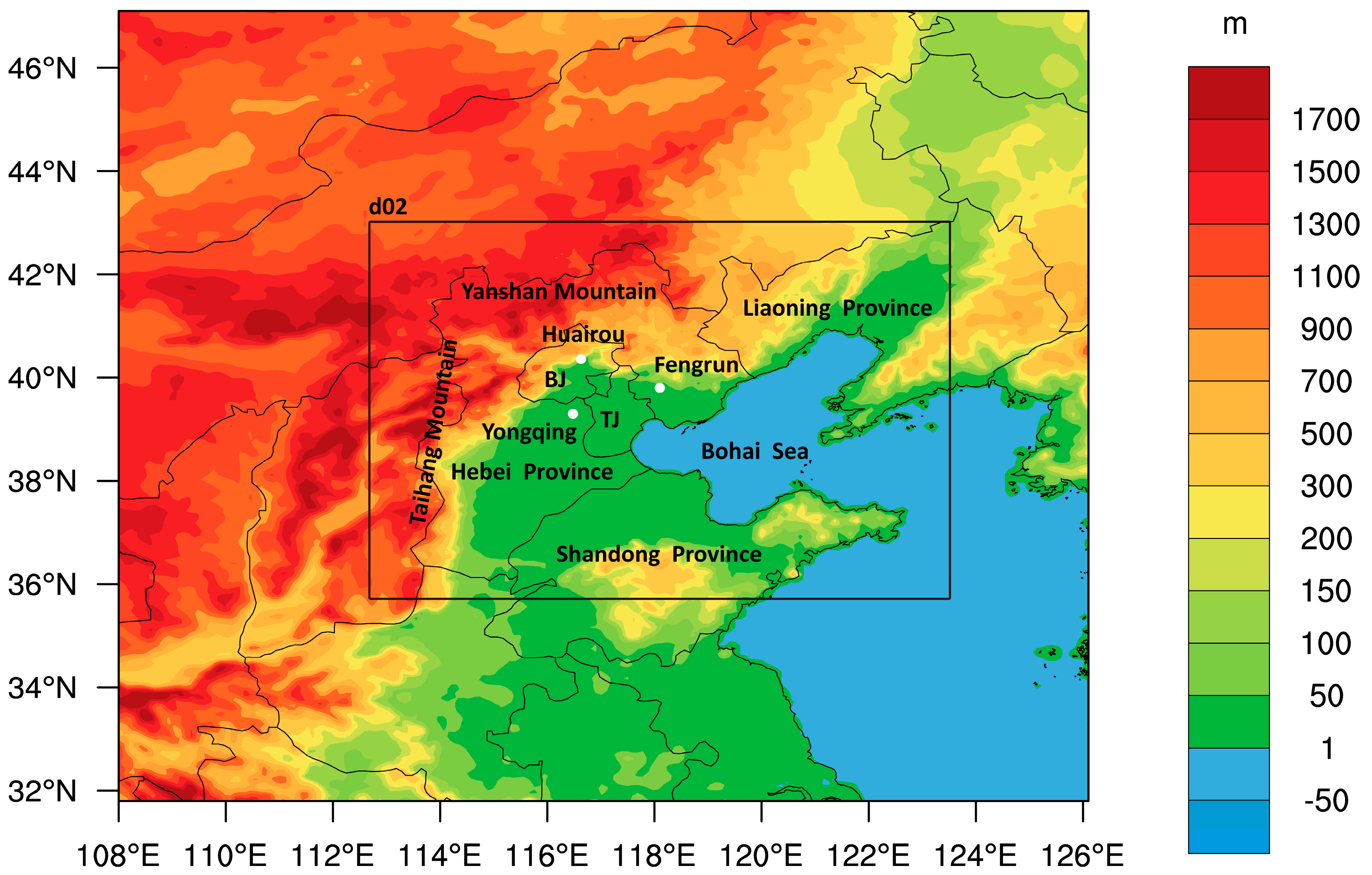
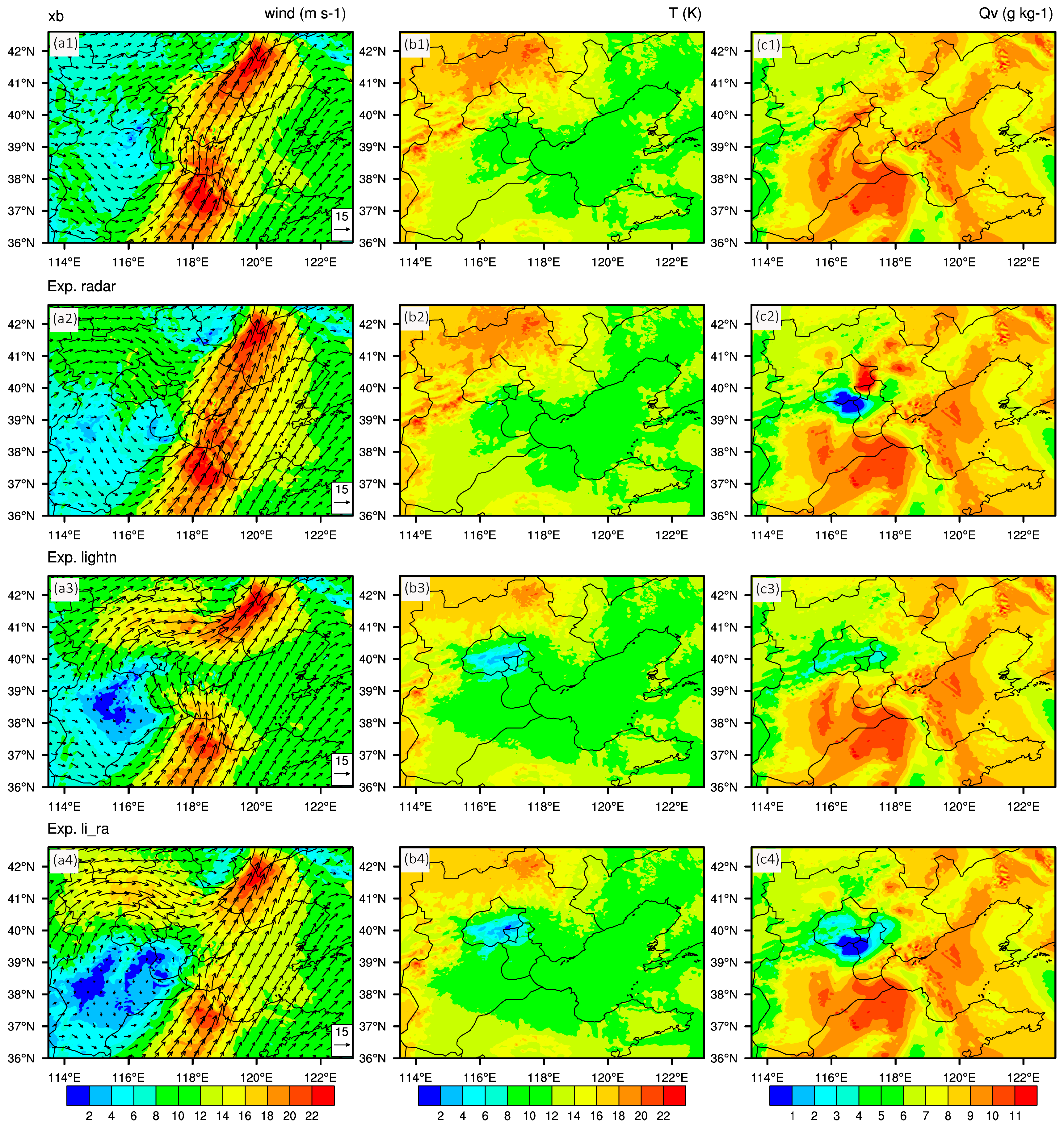
3.1. Analysis if the Terrain and Increments after Data Assimilation
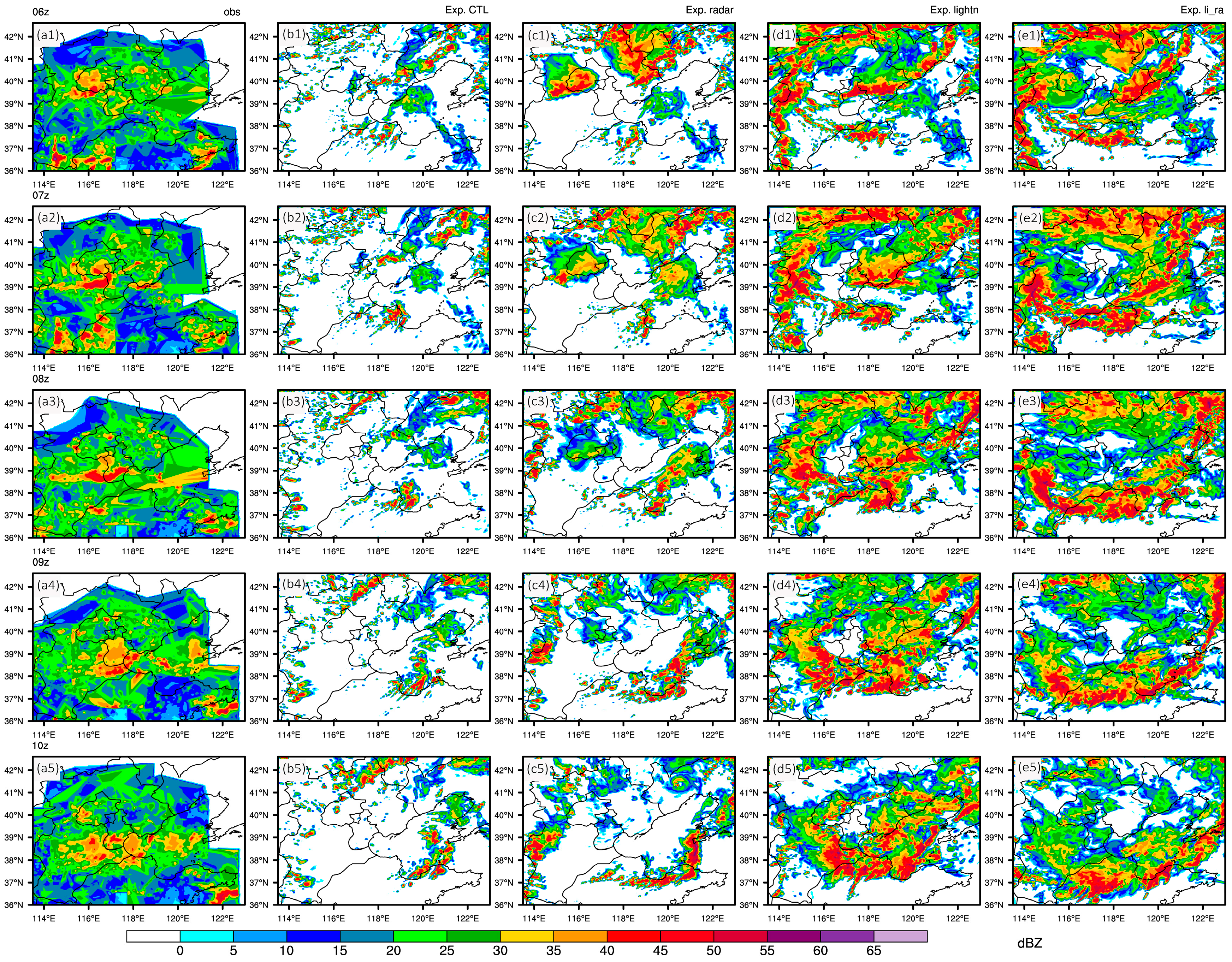
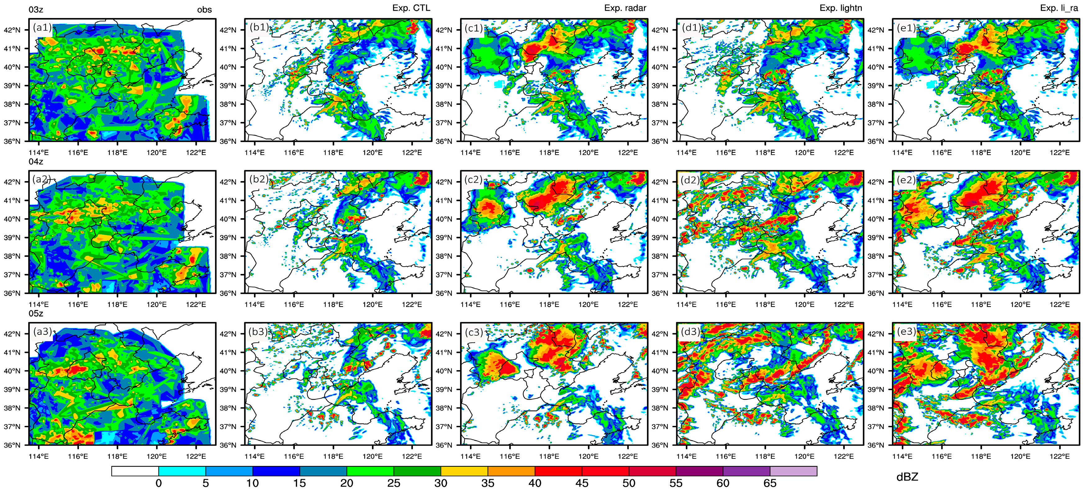
3.2. Analysis of the Forecast Maximum Reflectivity
3.3. Analysis of the Forecast Precipitation
3.4. Analysis of the Stratification Curve
4. Conclusions
- (1)
- Transforming total lightning data into proxy relative humidity is a simple and effective method, and assimilating lightning data with WRF-3DVAR can easily be implemented in many existing operational model platforms.
- (2)
- With sequential lightning data assimilation, forecast maximum reflectivity improves considerably and is sustained. Compared with assimilating radar reflectivity and radial velocity, assimilating lightning data can achieve a better improvement in the sustainment. In later hours, particularly in the assimilated lightning data region, the forecast maximum reflectivity in Exp. lightn is well reconstructed compared with the observations.
- (3)
- After assimilating lightning data, the 6 h accumulated precipitation forecast gains some improvements according to the fraction skill score at a spatial resolution of 50 km. The intensity of precipitation around assimilated lightning and neighboring areas is closer to the observations, although some regional precipitation is overestimated. The precipitation forecast in the downstream area is also considerably improved (e.g., both the position and intensity of the heavy rainfall center in Liaoning Province is corrected). However, a significant improvement cannot be achieved in Exp. lightn due to producing excessive false precipitation in the southern area. Thus, a future direction for lightning data assimilation research might be how to best use observations or methods to suppress spurious severe convection.
- (4)
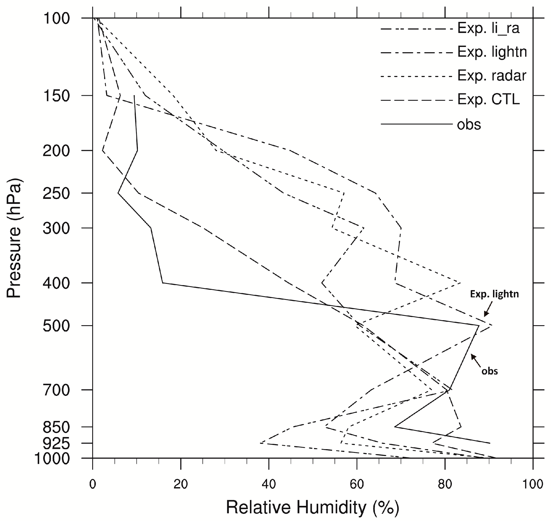
- Basing on sequential lightning data assimilation, Exp. lightn gives an obvious improvement in the stratification curve below 500 hPa at 7 h after the assimilation. Although the calculated convective available potential energy is smaller than the observation, the temperature and dew-point temperature profile match the observed, perfectly reconstructing humidity conditions from 700 hPa to 500 hPa.
Acknowledgments
Author Contributions
Conflicts of Interest
References
- Latham, J.; Petersen, W.A.; Deierling, W.; Christian, H.J. Field identification of a unique globally dominant mechanism of thunderstorm electrification. Q. J. R. Meteorol. Soc. 2007, 133, 1453–1457. [Google Scholar] [CrossRef]
- Reynolds, S.E.; Brook, M.; Gourley, M.F. Thunderstorm Charge Separation. J. Meteorol. 1957, 14, 426–436. [Google Scholar] [CrossRef]
- López, R.E.; Aubagnac, J.P. The lightning activity of a hailstorm as a function of changes in its microphysical characteristics inferred from polarimetric radar observations. J. Geophys. Res. 1997, 102, 16799–16813. [Google Scholar] [CrossRef]
- Sabbas, F.T.S.; Sentman, D.D. Dynamical relationship of infrared cloudtop temperatures with occurrence rates of cloud-to-ground lightning and sprites. Geophys. Res. Lett. 2003, 30. [Google Scholar] [CrossRef]
- Williams, E.R.; Weber, M.E.; Orville, R.E. The relationship between lightning type and convective state of thunderclouds. J. Geophys. Res. 1989, 94, 13213–13220. [Google Scholar] [CrossRef]
- Zhang, T.; Zhao, Z.; Zhao, Y.; Wei, C.; Yu, H.; Zhou, F. Electrical soundings in the decay stage of a thunderstorm in the Pingliang region. Atmos. Res. 2015, 164–165, 188–193. [Google Scholar] [CrossRef]
- Michaelides, S.; Savvidou, K.; Nicolaides, K. Relationships between lightning and rainfall intensities during rainy events in Cyprus. Adv. Geosci. 2010, 23, 87–92. [Google Scholar] [CrossRef] [Green Version]
- Stolz, D.C.; Businger, S.; Terpstra, A. Refining the relationship between lightning and convective rainfall over the ocean. J. Geophys. Res. Atmos. 2014, 119, 964–981. [Google Scholar] [CrossRef]
- Tapia, A.; Smith, J.A.; Dixon, M. Estimation of convective rainfall from lightning observations. J. Appl. Meteorol. 1998, 37, 1497–1509. [Google Scholar] [CrossRef]
- Zhou, Y.; Qie, X.; Soula, S. A study of the relationship between cloud-to-ground lightning and precipitation in the convective weather system in China. Ann. Geophys. 2002, 20, 107–113. [Google Scholar] [CrossRef]
- Stefanescu, R.; Navon, I.M.; Fuelberg, H.; Marchand, M. 1D+4D-VAR data assimilation of lightningwith WRFDA system using nonlinear observation operators. arXiv, 2013; arXiv:1306.1884. [Google Scholar]
- Tinmaker, M.I.R.; Aslam, M.Y.; Chate, D.M. Lightning activity and its association with rainfall and convective available potential energy over Maharashtra. India Nat. Hazards 2015. [Google Scholar] [CrossRef]
- Price, C.; Rind, D. A simple lightning parameterization for calculating global lightning distributions. J. Geophys. Res. 1992, 97, 9919–9933. [Google Scholar] [CrossRef]
- Benjamin, S. Assimilation of lightning data into RUC model convection forecasting. In Proceedings of the Second Conference on Meteorological Applications of Lightning Data, Tucson, AZ, USA; 2006. Available online: https://ams.confex.com/ams/Annual2006/techprogram/paper_105079.htm (accessed on 31 January 2006). [Google Scholar]
- Benjamin, S.; Weygandt, S.; Brown, J.; Smirnova, T.; Devenyi, D.; Brundage, K.; Grell, G.; Peckham, S.; Schlatter, T.; Smith, T. From the radar-enhanced RUC to the WRF-based Rapid Refresh. In Proceedings of the 18th Conference on Numerical Weather Prediction, Park City, UT, USA, 25–29 June 2007.
- Benjamin, S.G.; Dévényi, D.; Weygandt, S.S.; Brundage, K.J.; Brown, J.M.; Grell, G.A.; Kim, D.; Schwartz, B.E.; Smirnova, T.G.; Smith, T.L. An hourly assimilation-forecast cycle: The RUC. Mon. Weather Rev. 2004, 132, 495–518. [Google Scholar] [CrossRef]
- Weygandt, S.S.; Benjamin, S.G.; Smirnova, T.G.; Brown, J.M. Assimilation of lightning data using a diabatic digital filter within the Rapid Update Cycle. In Proceedings of the 12th Conference on IOAS-AOLS, New Orleans, LA, USA, 20–24 Jaunary 2008.
- Bovalo, C.; Barthe, C.; Pinty, J.; Chong, M. Potential of cloud-resolving model parameters to be used as proxies for the total flash rate. In Proceedings of theXV International Conference on Atmospheric Electricity, Norman, OK, USA, 15–20 June 2014.
- Barthe, C.; Deierling, W.; Barth, M.C. Estimation of total lightning from various storm parameters: A cloud-resolving model study. J. Geophys. Res. 2010, 115, D24202. [Google Scholar] [CrossRef]
- Deierling, W.; Petersen, W.A.; Latham, J.; Ellis, S.; Christian, H.J. The relationship between lightning activity and ice fluxes in thunderstorms. J. Geophys. Res. 2008, 113, D15210. [Google Scholar] [CrossRef]
- Deierling, W.; Petersen, W.A. Total lightning activity as an indicator of updraft characteristics. J. Geophys. Res. 2008, 113, D16210. [Google Scholar] [CrossRef]
- Kuhlman, K.M.; Ziegler, C.L.; Mansell, E.R.; MacGorman, D.R.; Straka, J.M. Numerically simulated electrification and lightning of the 29 June 2000 STEPS supercell storm. Mon. Weather. Rev. 2006, 134, 2734–2757. [Google Scholar] [CrossRef]
- Alexander, G.D.; Weinman, J.A.; Karyampudi, V.M.; Olson, W.S.; Lee, A.C.L. The Effect of Assimilating Rain Rates Derived from Satellites and Lightning on Forecasts of the 1993 Superstorm. Mon. Weather Rev. 1999, 127, 1433–1457. [Google Scholar] [CrossRef]
- Chang, D.E.; Weinman, J.A.; Morales, C.A.; Olson, W.S. The Effect of Spaceborne Microwave and Ground-Based Continuous Lightning Measurements on Forecasts of the 1998 Groundhog Day Storm. Mon. Weather Rev. 2001, 129, 1809–1833. [Google Scholar] [CrossRef]
- Papadopoulos, A.; Chronis, T.G.; Anagnostou, E.N. Improving convective precipitation forecasting through assimilation of regional lightning measurements in a mesoscale model. Mon. Weather. Rev. 2005, 133, 1961–1977. [Google Scholar] [CrossRef]
- Qie, X.; Zhu, R.; Yuan, T.; Wu, X.; Li, W.; Liu, D. Application of total-lightning data assimilation in a mesoscale convective system based on the WRF model. Atmos. Res. 2014, 145–146, 255–266. [Google Scholar] [CrossRef]
- Fierro, A.O.; Mansell, E.R.; Ziegler, C.L.; MacGorman, D.R. Application of a Lightning Data Assimilation Technique in the WRF-ARW Model at Cloud-Resolving Scales for the Tornado Outbreak of 24 May 2011. Mon. Weather Rev. 2012, 140, 2609–2627. [Google Scholar] [CrossRef]
- Gallus, W.A., Jr.; Segal, M. Impact of improved initialization of mesoscale features on convective system rainfall in 10-km Eta simulations. Weather Forecast. 2001, 16, 680–696. [Google Scholar] [CrossRef]
- Mansell, E.R.; Ziegler, C.L.; MacGorman, D.R. A Lightning Data Assimilation Technique for Mesoscale Forecast Models. Mon. Weather Rev. 2007, 135, 1732–1748. [Google Scholar] [CrossRef]
- Lagouvardos, K.; Kotroni, V.; Defer, E.; Bousquet, O. Study of a heavy precipitation event over southern France, in the frame of HYMEX project: Observational analysis and model results using assimilation of lightning. Atmos. Res. 2013, 134, 45–55. [Google Scholar] [CrossRef]
- Mansell, E.R. Storm-Scale Ensemble Kalman Filter Assimilation of Total Lightning Flash-Extent Data. Mon. Weather Rev. 2014, 142, 3683–3695. [Google Scholar] [CrossRef]
- Wang, Y.; Yang, Y.; Wang, C. Improving forecasting of strong convection by assimilating cloud-to-ground lightning data using the physical initialization method. Atmos. Res. 2014, 150, 31–41. [Google Scholar] [CrossRef]
- Yang, Y.; Wang, Y.; Zhu, K. Assimilation of Chinese Doppler Radar and Lightning Data Using WRF-GSI: A Case Study of Mesoscale Convective System. Adv. Meteorol. 2015. [Google Scholar] [CrossRef]
- Yang, Y.; Qiu, C.; Gong, J. Physical initialization applied in WRF-Var for assimilation of Doppler radar data. Geophys. Res. Lett. 2006, 33. [Google Scholar] [CrossRef]
- Marchand, M.R.; Fuelberg, H.E. Assimilation of Lightning Data Using a Nudging Method Involving Low-Level Warming. Mon. Weather Rev. 2014, 142, 4850–4871. [Google Scholar] [CrossRef]
- Fierro, A.O.; Gao, J.; Ziegler, C.L.; Mansell, E.R.; MacGorman, D.R. Evaluation of a Cloud-Scale Lightning Data Assimilation Technique and a 3DVAR Method for the Analysis and Short-Term Forecast of the 29 June 2012 Derecho Event. Mon. Weather Rev. 2014, 142, 183–202. [Google Scholar] [CrossRef]
- Fierro, A.O.; Clark, A.J.; Mansell, E.R.; Macgoraman, D.R.; Dembek, S.R.; Ziegler, C.L. Impact of Storm-Scale Lightning Data Assimilation on WRF-ARW Precipitation Forecasts during the 2013 Warm Season over the Contiguous United States. Mon. Weather Rev. 2015, 143, 757–777. [Google Scholar] [CrossRef]
- Zou, X.; Navon, I.M.; LeDimet, F.X. An Optimal Nudging Data Assimilation Scheme Using Parameter Estimation. Q. J. R. Meteorol. Soc. 1992, 118, 1163–1186. [Google Scholar] [CrossRef]
- Sun, J. Convective-scale assimilation of radar data: Progress and challenges. Q. J. R. Meteorol. Soc. 2005, 131, 3439–3463. [Google Scholar] [CrossRef]
- Sun, J.; Xue, M.; Wilson, J.; Zawadzki, I.; Ballard, S.; Onvlee-Hooimeyer, J.; Joe, P.; Barker, D.; Li, P.; Golding, B.; et al. Use of NWP for Nowcasting Convective Precipitation: Recent Progress and Challenges. Bull. Am. Meteorol. Soc. 2014, 95, 409–426. [Google Scholar] [CrossRef]
- Parrish, D.F.; Derber, J.C. The National Meteorological Center’s Statistical SpectralInterpolation Analysis System. Mon. Weather Rev. 1992, 109, 1747–1763. [Google Scholar] [CrossRef]
- Xiao, Q.; Guo, Y.H.; Sun, J.; Lee, W.C.; Barker, D.M.; Lim, E. An Approach of Radar Reflectivity Data Assimilation and Its Assessment with the Inland QPF of Typhoon Rusa (2002) at Landfall. J. Appl. Meteorol. Clim. 2007, 46, 14–22. [Google Scholar] [CrossRef]
- Sun, J.; Crook, N.A. Dynamical and Microphysical Retrieval from Doppler Radar Observations Using a Cloud Model and Its Adjoint. Part I: Model Development and Simulated Data Experiments. J. Atmos. Sci. 1997, 54, 1642–1661. [Google Scholar] [CrossRef]
- Meng, Q.; Ge, R.S.; Zhu, X.Y. SAFIR lightning monitoring and alerting system. Meteorol. Sci. Technol. 2002, 30, 135–138. [Google Scholar]
- Li, X.J. Analysis of Lightning Characteristics Based on SAFIR Data in Beijing and Its Circumjacent Regions. Master’s Thesis, Nanjing University of Information Science and Technology, Nanjing, China, June 2011. [Google Scholar]
- Hong, S.-Y.; Lim, J.-O.J. The WRF Single-Moment 6-Class Microphysics Scheme (WSM6). J. Korean Meteorol. Soc. 2006, 42, 129–151. [Google Scholar]
- Mlawer, E.J.; Taubman, S.J.; Brown, P.D.; Iacono, M.J.; Clough, S.A. Radiative transfer for inhomogeneous atmospheres: RRTM, a validated correlated-k model for the longwave. J. Geophys. Res. Atmos. 1997, 102, 16663–16682. [Google Scholar] [CrossRef]
- Chou, M.-D.; Suarez, M.J. A solar radiation parameterization for atmospheric studies. NASA Tech. Memo 1999, 104606, 40. [Google Scholar]
- Smirnova, T.G.; Brown, J.M.; Benjamin, S.G. Performance of different soil model configurations in simulating ground surface temperature and surface fluxes. Mon. Weather Rev. 1997, 125, 1870–1884. [Google Scholar] [CrossRef]
- Nakanishi, M. Improvement of the Mellor-Yamada turbulence closure model based on large-eddy simulation data. Bound. Layer Meteorol. 2001, 99, 349–378. [Google Scholar] [CrossRef]
- Grell, G.A. Prognostic Evaluation of Assumptions Used by Cumulus Parameterizations. Mon. Weather Rev. 1993, 121, 764–787. [Google Scholar] [CrossRef]
- Grell, G.A.; Dévényi, D. A generalized approach to parameterizing convection combining ensemble and data assimilation techniques. Geophys. Res. Lett. 2002, 29, 1693. [Google Scholar] [CrossRef]
- Li, H.; Cai, Z.; Xu, Y. A Numereical Experiment of Topographic Effect on Genesis of the Squall Line in North China. Chin. J. Atmos. Sci. 1999, 23, 714–721. [Google Scholar]
- Roberts, N.M.; Lean, H.W. Scale-selective verification of rainfall accumulations from high-resolution forecasts of convective events. Mon. Weather Rev. 2008, 136, 78–97. [Google Scholar] [CrossRef]





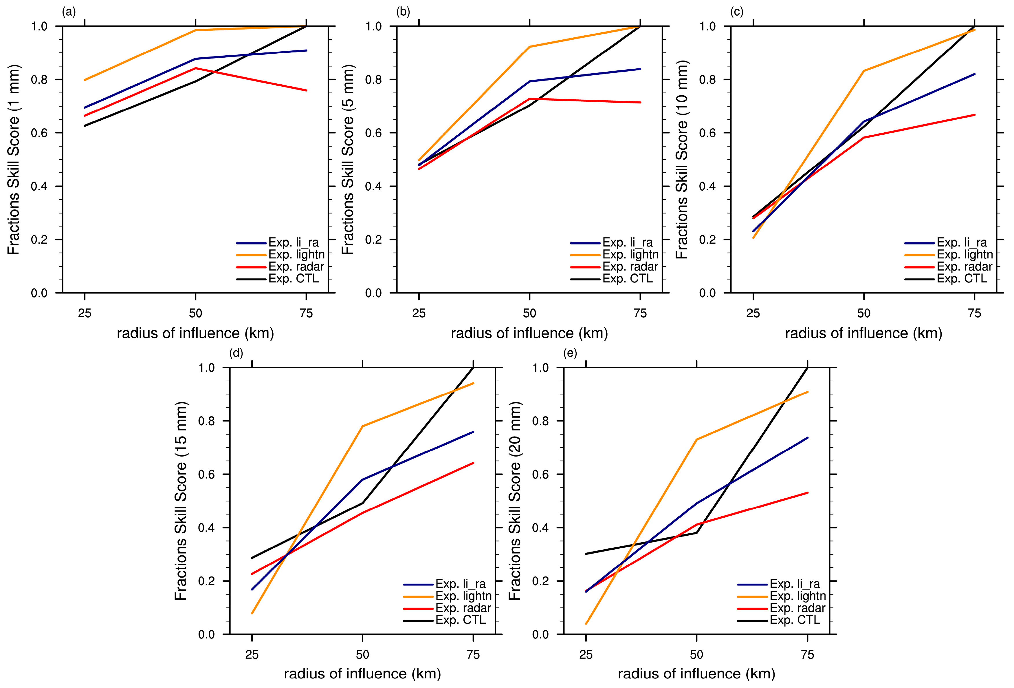

| Category | Thresholds | Exp. CTL | Exp.Radar Radar | Exp.LightnLilililightn | Exp.li_ra |
|---|---|---|---|---|---|
| TS | 1 mm | 0.44 | 0.47 | 0.47 | 0.50 |
| 5 mm | 0.21 | 0.26 | 0.22 | 0.23 | |
| 10 mm | 0.07 | 0.15 | 0.09 | 0.12 | |
| 15 mm | 0.02 | 0.09 | 0.04 | 0.05 | |
| 20 mm | 0.01 | 0.08 | 0.04 | 0.03 | |
| FAR | 1 mm | 0.33 | 0.39 | 0.47 | 0.43 |
| 5 mm | 0.61 | 0.63 | 0.75 | 0.72 | |
| 10 mm | 0.87 | 0.78 | 0.90 | 0.86 | |
| 15 mm | 0.96 | 0.87 | 0.95 | 0.94 | |
| 20 mm | 0.98 | 0.88 | 0.95 | 0.96 | |
| POD | 1 mm | 0.56 | 0.68 | 0.80 | 0.81 |
| 5 mm | 0.32 | 0.47 | 0.59 | 0.61 | |
| 10 mm | 0.15 | 0.32 | 0.39 | 0.41 | |
| 15 mm | 0.05 | 0.21 | 0.22 | 0.18 | |
| 20 mm | 0.02 | 0.18 | 0.22 | 0.09 |
© 2017 by the authors. Licensee MDPI, Basel, Switzerland. This article is an open access article distributed under the terms and conditions of the Creative Commons Attribution (CC BY) license ( http://creativecommons.org/licenses/by/4.0/).
Share and Cite
Wang, Y.; Yang, Y.; Liu, D.; Zhang, D.; Yao, W.; Wang, C. A Case Study of Assimilating Lightning-Proxy Relative Humidity with WRF-3DVAR. Atmosphere 2017, 8, 55. https://doi.org/10.3390/atmos8030055
Wang Y, Yang Y, Liu D, Zhang D, Yao W, Wang C. A Case Study of Assimilating Lightning-Proxy Relative Humidity with WRF-3DVAR. Atmosphere. 2017; 8(3):55. https://doi.org/10.3390/atmos8030055
Chicago/Turabian StyleWang, Ying, Yi Yang, Dongxia Liu, Dongbin Zhang, Wen Yao, and Chenghai Wang. 2017. "A Case Study of Assimilating Lightning-Proxy Relative Humidity with WRF-3DVAR" Atmosphere 8, no. 3: 55. https://doi.org/10.3390/atmos8030055
APA StyleWang, Y., Yang, Y., Liu, D., Zhang, D., Yao, W., & Wang, C. (2017). A Case Study of Assimilating Lightning-Proxy Relative Humidity with WRF-3DVAR. Atmosphere, 8(3), 55. https://doi.org/10.3390/atmos8030055


