Article

Beyond Global Trends: Two Decades of Climate Data in the World’s Highest Equatorial City

by
Rasa Zalakeviciute
1,*,
Fidel Vallejo
2,3,
Bolívar Erazo
4,5,
Oscar Chimborazo
6,7,
Santiago Bonilla-Bedoya
8,
Danilo Mejia
9,
Tobias Isaac Tapia-Flores
1,
Genesis Chuquimarca
1 and
Yves Rybarczyk
10
1
Biodiversidad, Medio Ambiente y Salud (BIOMAS), Universidad de Las Americas, Quito 170513, Ecuador
2
Industrial Engineering, National University of Chimborazo, Riobamba 060108, Ecuador
3
ProcesLab Research Group, National University of Chimborazo, Riobamba 060108, Ecuador
4
Instituto Nacional de Meteorología e Hidrología (INAMHI), Quito 170517, Ecuador
5
Departamento de Gestión de Recursos Hídricos, Empresa Pública Metropolitana de Agua Potable y Saneamiento de Quito, EPMAPS Agua de Quito, Quito 170519, Ecuador
6
NOAA Cooperative Science Center in Atmospheric Sciences and Meteorology (NCAS-M), Howard University, 1328 Florida Ave NW, B-211, Washington, DC 20009, USA
7
Grupo Hydroclima, Yachay Tech University, Urcuquí 100119, Ecuador
8
Research Center for the Territory and Sustainable Habitat, Universidad Tecnológica Indoamérica, Machala y Sabanilla, Quito 170103, Ecuador
9
Grupo CATOx, CEA de La Universidad de Cuenca, Campus Balzay, Cuenca 010207, Ecuador
10
School of Information and Engineering, Dalarna University, 791 88 Falun, Sweden
*
Author to whom correspondence should be addressed.
Atmosphere 2025, 16(9), 1080; https://doi.org/10.3390/atmos16091080 (registering DOI)
Submission received: 22 July 2025 / Revised: 7 September 2025 / Accepted: 8 September 2025 / Published: 12 September 2025
(This article belongs to the Section Climatology)

Abstract

While humanity stands at a critical point—one future leading toward sustainability, equity, and resilience, the other toward escalating conflicts, ecological collapse, and irreversible loss—climate change emerges as one of the most urgent challenges of the 21st century. The Global South, specifically the northwestern South American region, lacks model confidence and reports on current climatic conditions due to gaps in historical data. This study, therefore, presents temperature and precipitation trends in the highest city on the equator, Quito, Ecuador, from 2004–2024. Six different districts were analyzed for maximum, average, and minimum temperatures, as well as cumulative precipitation, in terms of monthly and annual statistics, using Seasonal-Trend Decomposition. Over the past two decades, this Andean city has warmed by an average of +0.95 °C, with minimum temperatures rising at rates twice the global urban average of extreme urban heat islands (+2.47 °C), while precipitation has nearly doubled in rapidly developing parts of the city. These profound changes, shaped by urban expansion, El Niño–Southern Oscillation variability, and climate change, demand urgent adaptation in water management, urban planning, and climate resilience strategies, as well as comparative studies with rural Ecuador to differentiate local vs. regional climate signatures.

1. Introduction

Humanity currently stands at a crossroads between two future futures: one of sustainability, poverty eradication, and technological advancement; or, conversely, one of increasing inequality, armed conflicts, ecological crises, and insufficient progress in addressing the impacts of climate change [1]. The unprecedented surge in global population—an increase of approximately two billion people over 23 years (1999–2022)—combined with the relentless release of anthropogenic greenhouse gases, is driving continuously intensifying global warming, regarded as the most critical health threat facing humanity [2,3,4,5]. While the Paris Agreement aims to limit the global average temperature increase to well below 2 °C (preferably not much over 1.5 °C) compared to pre-industrial levels, by 2024, global surface temperatures had already reached 1.47 °C above pre-industrial values, marking the hottest year on record and signaling how dangerously close we are to breaching the 1.5 °C threshold [6,7,8,9]. Consequently, rising temperatures are triggering a wide range of environmental, climatic, and social impacts, including biodiversity loss, human casualties, damage to infrastructure, threats to food security, population displacement, and reduced electricity production, among others [10].
Although climate change poses a universal challenge, Latin America—and particularly northwestern South America (NWS), which includes Ecuador—exhibits distinct vulnerabilities. With over 80% of its population residing in urban areas, this region is considered one of the most climate-sensitive in the world [11,12]. Complex socio-economic factors such as poverty, inequality, and political and economic instability further heighten the region’s climate vulnerability [13,14]. Despite contributing minimally to global greenhouse gas emissions, countries in the NWS region have experienced a 30–50% retreat of tropical Andean glaciers since the 1980s, leading to reduced water availability, heightened risks of floods and landslides, disrupted hydropower generation, and pronounced shifts in temperature and precipitation regimes [12]. These changes directly affect urban centers such as Quito by increasing flood susceptibility, threatening water supplies, impacting agriculture and hydropower, and accelerating biodiversity loss [13,15,16]. The regional climate stressors outlined above underscore the urgent need for localized studies on temperature and rainfall trends to inform targeted adaptation and resilience strategies.
Previous studies emphasize persistent deficiencies in long-term climate data coverage across many developing regions [17,18]. Within the NWS, few studies incorporate adequate station density, temporal duration, or spatial representativeness, resulting in low confidence in future projections for this area. Limited observational networks and non-representative sampling introduce substantial uncertainties into climate forecasts, particularly regarding shifts in precipitation extremes [12]. Temperature trends show rates exceeding global averages across several South American sub-regions, with warming particularly pronounced in the NWS [12]. At the same time, Andean glaciers continue to experience some of the most significant mass losses worldwide [19,20,21,22]. Model projections suggest potential reductions in precipitation of 20–30% in Ecuador and nearby portions of the northern tropical Andes [23,24], which would place additional stress on water resources and agriculture [12]. The high climatic sensitivity of the tropical Andes, combined with substantial microclimatic variability over short distances, suggests that broad generalizations may obscure critical local adaptation needs.
The Ecuadorian capital, Quito, represents a relevant case study due to its rapid demographic and spatial transformations [25]. Urban expansion into surrounding valleys and increased densification have likely intensified urban heat island effects, driven by higher pollutant emissions, deforestation, and the spread of impervious surfaces [26]. These dynamics, combined with the city’s elevation and complex topography, likely influence local climate responses in ways that remain insufficiently documented. Global temperature datasets often adjust urban records to remove the urban heat island effect, meaning that cities such as Quito are not fully represented in their unadjusted form. This can hinder assessments of urban climate vulnerabilities [27]. The scarcity of publications from Central and South America does not reflect reduced exposure or sensitivity to climate change impacts, but is instead largely attributable to structural factors such as limited long-term observations and institutional capacity [28].
Given that global surface temperatures have risen at an unprecedented pace, with rates accelerating markedly over the past 24 years [2,10], this study seeks to address critical data gaps by quantifying temperature and precipitation trends in Quito from 2004 to 2024. It examines their links to global climate drivers (e.g., El Niño–Southern Oscillation, ENSO) and local factors such as urban expansion and land-use change, thereby providing essential high-resolution insights to inform adaptation strategies in high-elevation tropical urban environments.

2. Materials and Methods

2.1. Study Site

Quito, the capital of Ecuador, is often cited as the world’s highest constitutional capital, standing at 2850 m above sea level (ASL) (Figure 1) [29]. Its metropolitan area of 4,183 km2 spans about 95 km along its north–south axis and about 40 km east–west. This territory encompasses a substantial elevational range, crossing the equator and intersected by two principal Andean mountain chains: the Eastern Cordillera, which rises to elevations near 4100 m ASL, and the Western Cordillera, reaching up to around 4800 m ASL [30]. This combination of topographical complexity results in a range of tropical climatic zones and natural ecosystems [30].
Quito’s population now exceeds 2.7 million residents, effectively doubling within the past twenty years and reflecting substantial urban growth and transformation of its surrounding landscapes [31]. Despite significant socio-economic and environmental constraints, Quito maintains a generally temperate, spring-like climate, characterized by two primary seasons: an extended wet period from September to May and a drier interval from June to August [32]. The temperature in this region shows little seasonal variation, maintaining an annual mean of approximately 13.4 °C, although it is marked by substantial diurnal fluctuations, with daytime highs reaching around 29.9 °C and nighttime lows dropping to approximately 1.5 °C [33,34]. Finally, the city’s high-altitude location results in elevated solar and UV radiation [35].
For this work data from six meteorological stations representing different districts of Quito were investigated: (1) Carapungo (2660 m ASL, coord. 78°26′50″ W, 0°5′54″ S); (2) Cotocollao (2739 m ASL, coord. 78°29′50″ W, 0°6′28″ S); (3) Belisario (2,835 m ASL, coord. 78°29′24″ W, 0°10′48″ S); (4) Tumbaco (2,355 m ASL, coord. 78°24′12.4164″ W, 0°12′53.334″ S); (5) Camal (2,840 m ASL, coord. 78°30′36″ W, 0°15′00″ S); and (6) Chillos (2453 m ASL, coord. 78°27′36″ W, 0°18′00″ S) (Figure 1 shows the spatial distribution of the stations). Study sites 4 and 6 are located in recently rapidly developing suburban, lower-elevation valley districts.

2.2. Data Acquisition and Analysis

The municipal office, the Secretaría de Ambiente de Quito, has operated the atmospheric monitoring network since 2004. Air temperature was measured using a Thies Clima Hygro-Thermo Transmitter compact sensor (Model 1.1005.54.161). Precipitation was measured using a Thies Clima tipping bucket rain gauge (Model 5.4003.2007) (Adolf Thies GmbH & Co. KG, Göttingen, Germany). Data acquisition and storage were performed with an Agilaire 8872 data logger (Agilaire, LLC, Knoxville, TN, USA). These instruments provided continuous measurements essential for analyzing local climatic variability. The collected data are stored in the municipal administration’s repository and are available for download at https://datosambiente.quito.gob.ec/ (accessed on 20 May 2025).
The analysis of temperature and precipitation trends in Quito, Ecuador, from 2004 to 2024 was conducted using a combination of data extraction, processing, and statistical techniques. The AirEcuador v0.2 [36] package was used for data retrieval, and the OpenAir v2.19.0 [37] was employed for time-series analysis.
The dataset was extracted from the Secretaría de Ambiente de Quito’s repository and filtered to cover the period from 1 January 2004 to 31 December 2024, ensuring a consistent 21-year timeframe. Two sites contain incomplete datasets: (4) El Camal, which spans 1 January 2004 to 31 December 2022; and (6) Tumbaco, which begins in October 2006. Data loss across all stations was less than 5%, which was deemed sufficient for analysis. Missing values and potential infinities were removed to ensure data integrity, with days containing incomplete records (i.e., <75% of daily data or fewer than 18 of 24 h) excluded from monthly and annual statistics. The raw data underwent quality control using the AirEcuador package, which removed anomalous values at the 99.9th percentile, as the Secretaría de Ambiente repository provides unprocessed data. Subsequently, the data were transformed into a long-format structure using the tidyr v1.3.1 package, with precipitation values aggregated monthly using the dplyr v 1.1.4 package. To ensure comparability across sites, analyses focused on overlapping data periods where available, maximizing the use of the 2004–2024 timeframe.
Monthly precipitation sums were calculated for each station, and annual totals were derived using the timeAverage function from the OpenAir package. To explore long-term trends, a Seasonal-Trend Decomposition using LOESS (STL) was applied to the monthly time-series data for each station [38]. The STL decomposition, implemented using the stl function from the forecast package [39], employed a periodic seasonal window and robust fitting to extract the trend component, thereby accommodating nonlinear changes over the 21-year period. The isolated trend component was then evaluated using the Mann–Kendall test to assess statistical significance, while total changes (Δ) over the study period were derived directly from differences in the STL trend.
This approach isolates the nonlinear trend component while preserving the data’s absolute scale (°C or mm), thereby facilitating direct interpretation of long-term shifts in typical temperature and precipitation levels. Because the primary objective was to quantify gradual changes in the baseline climate rather than transient departures from expected seasonal patterns, anomaly analysis was not performed. The STL decomposition effectively accounts for periodic seasonality, allowing robust estimation of multi-decadal trends without requiring explicit conversion to anomalies.
The graphical representation was constructed using ggplot2 [40]. The STL trend lines were overlaid to illustrate the smoothed long-term trajectory. To quantify changes, the percentage delta (Δ) was calculated for each station, representing the relative change in the STL trend between the base period and December 2024. The baseline was defined as the STL-derived trend value in 2004 (or the first available year of data for stations with shorter records), and the final value was taken as the STL trend for December 2024 (or the last available year of data). The Δ was computed as ((Trend_final − Initial_value)/Trend_base) × 100, with the results annotated on the graphs. The total change (Δ) over the period is reported with 95% confidence intervals (CI), computed using the bootstrap method, representing, together with the p-value, the statistical significance of the trend (Mann–Kendall test).
The influence of ENSO was assessed by integrating the Oceanic Niño Index (ONI) from NOAA
Monthly ONI 3.4 values were compared with citywide averages of monthly temperatures and precipitation accumulation.
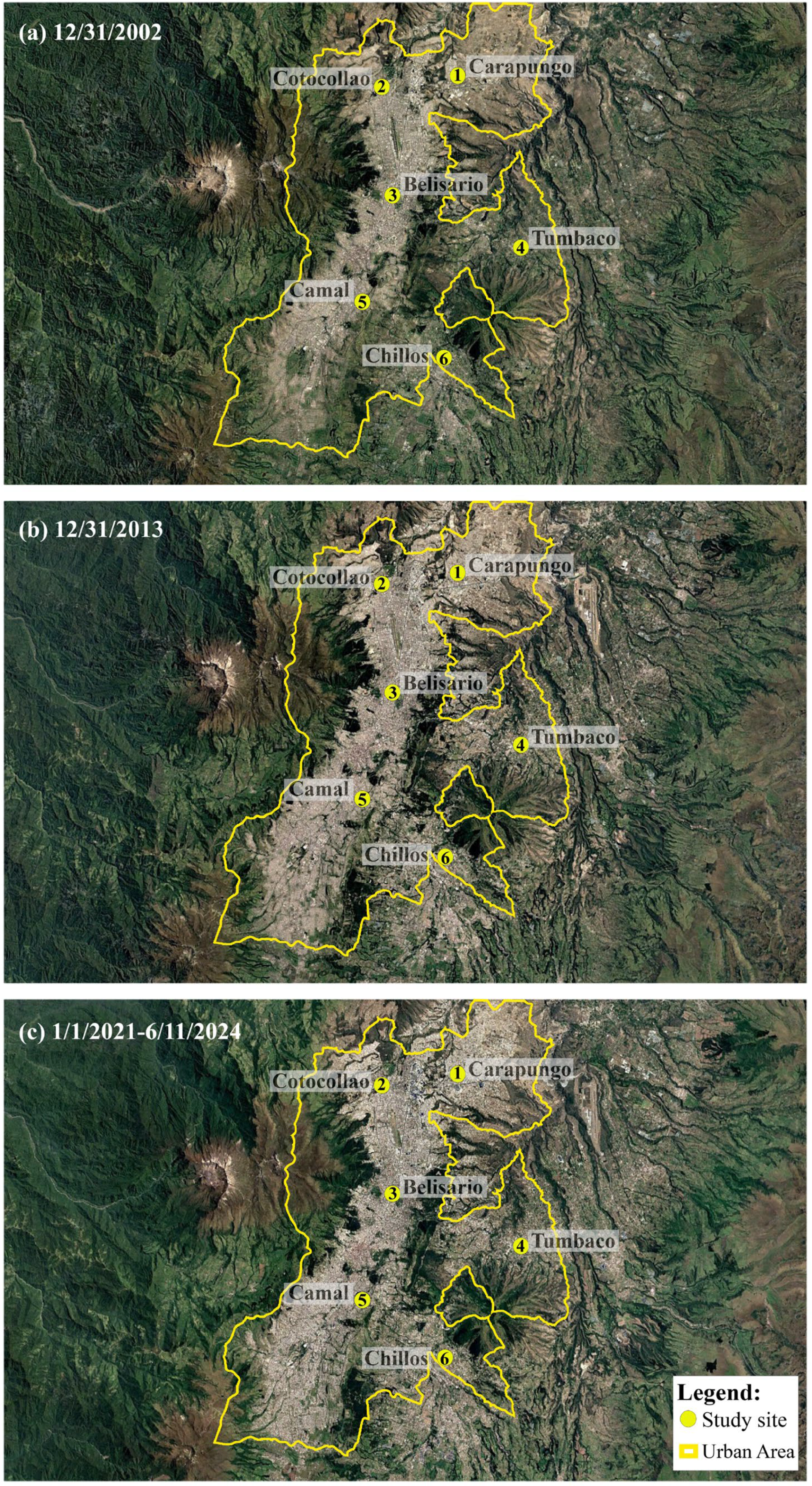
Satellite images to observe land-cover changes in the Quito region were retrieved from Google Earth for three stages representing the study period: (i) 12/31/2002; (ii) 12/31/2013; and (iii) 1/1/2021–6/11/2024, by shifting the historical tool on the Google Earth website. Different satellite dataset were used to produce the maps: Landsat/Copernicus (i,ii) and AirbusCNES/AirbusMaxar TechnologiesLandsat/Copernicus (iii) (retrieved from: https://earth.google.com/web/@-0.1927554,-78.3637257,2472.83099683a,68795.46412996d,35y,0.09904646h,0t,0r/data=CgRCAggBOgMKATBCAggASg0I____________ARAA (accessed on 18 July 2025)).

3. Results and Discussion

3.1. Temperature Trends in Quito over 2004–2024

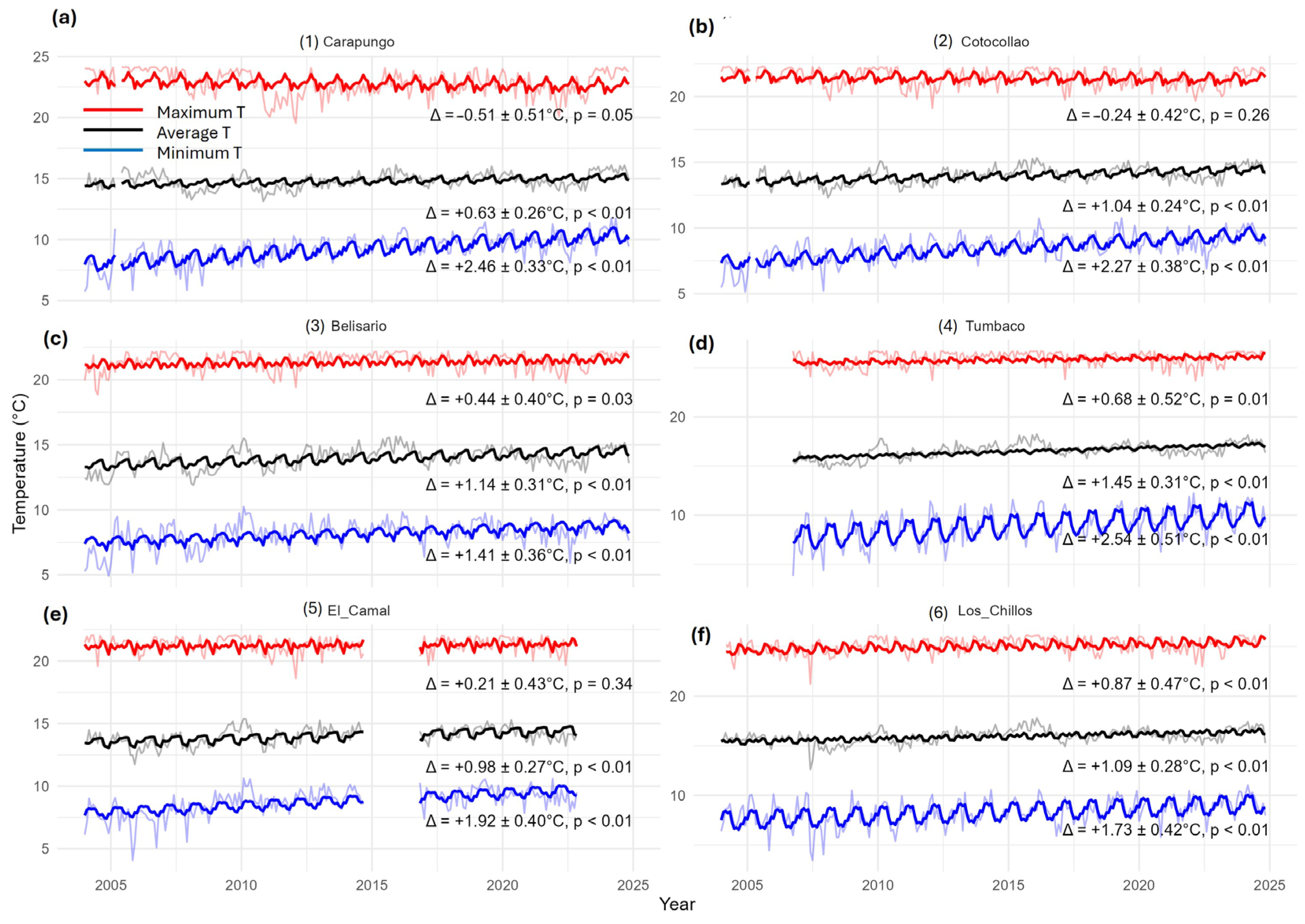
Temperature pattern analysis (with seasonality removed), using average, minimum, and maximum monthly time series, revealed a consistent warming trend at all six sites in Quito, except for maximum temperature at two northern sites: (1) Carapungo and (2) Cotocollao (Figure 2). Statistically significant (p < 0.01; CI: 95%) increases in average monthly temperatures ranged from +0.63 ± 0.26 °C to +1.45 ± 0.31 °C, equivalent to annual rates between +0.30 °C/decade and +0.79 °C/decade, with a city-wide average of +0.52 °C/decade (Figure 2, black lines). Minimum monthly temperatures show even more pronounced significant increases (p < 0.01), ranging from +1.45 ± 0.37 °C to +2.57 ± 0.51 °C, or +0.69 °C/decade to +1.41 °C/decade, averaging +1.02 °C/decade city-wide (Figure 2, blue lines). Meanwhile, changes in maximum monthly temperatures varied from −0.51 ± 0.51 °C to +0.87 ± 0.47 °C, yielding a city-wide mean of +0.12 °C/decade. Excluding non-significant trends in (1) Carapungo, (2) Cotocollao, and (5) Camal, this rose to +0.33 °C/decade (Figure 2, red lines). Notably, although two northern sites (Sites 1 and 2) exhibited negative slopes for maximum temperatures, these were not statistically significant (p ≥ 0.05; CI:95%), indicating no robust directional change in those districts.
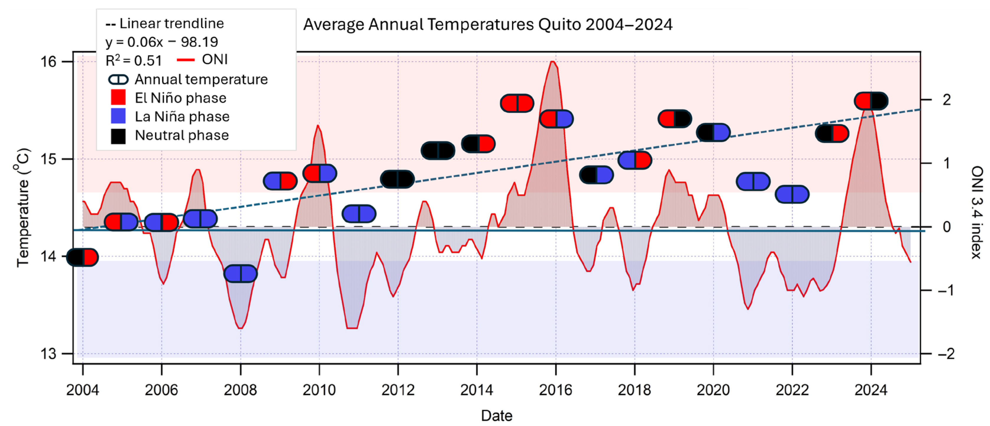
Analysis of annual data supports these results, indicating that the mean temperature across Quito has increased by 1.2 °C over the past 21 years, corresponding to an average rate of 0.57 °C per decade (Figure 3). This closely matches the monthly trend of +0.95 °C, confirming consistency across temporal scales.
The observed changes in average temperatures align with globally reported urban warming rates. However, minimum monthly temperatures in Quito have increased at roughly twice the global rate for urban areas. Meanwhile, maximum temperatures are much lower than globally reported values. For comparison, a recent global analysis (2002–2021) reported increases of +0.50 ± 0.20 °C/decade for average temperatures, +0.56 ± 0.21 °C/decade for minimum temperatures, and +0.43 ± 0.16 °C/decade for maximum temperatures [41]. Our results closely resemble the averages reported by the global study on extreme urban heat islands, where temperatures have risen by ~1 °C since 2003 [42]. In our study, Quito’s average temperature increased by 0.95 °C over a comparable period. We note, however, that the (4) Tumbaco site, which exhibited the highest warming trend, had limited early-year data availability, which may have influenced the magnitude of the detected trend (Figure A2, Appendix A).
These elevated rates likely reflect the combined effects of rapid, often unregulated urban expansion, limited investment in climate-adaptive infrastructure, and weaker environmental governance, patterns commonly observed in cities of the developing world [41,43]. Over the past two decades alone, Quito’s population has more than doubled, from 1.3 to 2.7 million, accompanied by substantial growth in the vehicle fleet. This growth coincided with major new road construction toward the eastern valley (notably, Tumbaco), adding nearly 30 km of paved infrastructure between 2011 and 2015. Urban expansion has often replaced rural lands and led to densification of urban and suburban zones, where traditional single-family homes with gardens have been replaced by high-rise residential and office buildings.
Among the study sites, the rapidly developing peripheral district (4) Tumbaco recorded the highest increase in average and minimum monthly temperatures over the last 18 years, +1.45 °C and +2.57 °C, respectively (Figure 2d and Figure A2a, Appendix A). Therefore, the actual long-term warming may be underestimated. Finally, the largest changes in maximum temperatures were recorded in both rapidly developing peripheral lower valley districts, ranging from +0.68 °C to + 0.87 °C, respectively. These findings are consistent with an intensifying urban heat island (UHI) effect [26]. In these two districts, a rapid conversion of natural ecosystems and farmland into residential developments is evident (Figure A1, Appendix A). Here, the probability of transition from vegetated to impervious surfaces is particularly high [44], which has implications for both the water cycle and urban albedo [45]. This UHI effect is likely compounded by reduced vegetation cover and increased heat absorption from impervious surfaces. Conversely, more established central districts such as Belisario, which maintain greater green space, show a more moderate UHI impact (Figure 2c), emphasizing the role of urban greening in mitigating temperature rise. This agrees with previous findings that while green infrastructure provides cooling benefits, it does not fully offset UHI intensification [46,47].
Residential growth has also extended into surrounding valleys and up the slopes of the metropolitan area, frequently taking place outside formal planning frameworks and, in many cases, violating land-use regulations [48]. In contrast, the historic center of Quito has seen limited physical expansion due to land scarcity, high population density, traffic congestion, and aging infrastructure. As a result, urban growth has increasingly shifted into nearby valleys, placing additional pressure on vital resources such as water supplies and agricultural lands. As this study demonstrates, this pattern of expansion is also associated with notable local temperature increases, raising important concerns about the long-term sustainability of these developments [49].

3.2. Precipitation Trends in Quito over 2004–2024

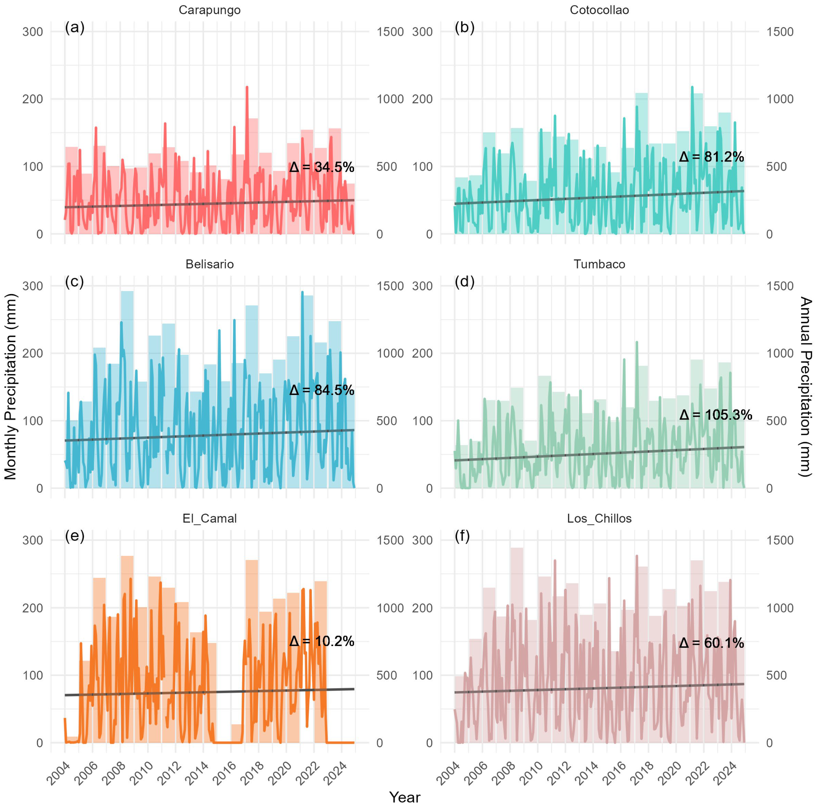
Two southern sites, (5) El Camal (Figure 4e) and (6) Los Chillos (Figure 4f), along with the central site (3) Belisario (Figure 4c), ranked among the wettest districts, with average annual totals of 975 mm, 1,037 mm, and 998 mm, respectively. In contrast, northern sites (1) Carapungo (Figure 4a) and (2) Cotocollao (Figure 4b) recorded lower annual means of 580 mm and 688 mm, reflecting generally drier conditions, while (4) Tumbaco (Figure 4d) in the eastern valley was the driest at 657 mm/year.
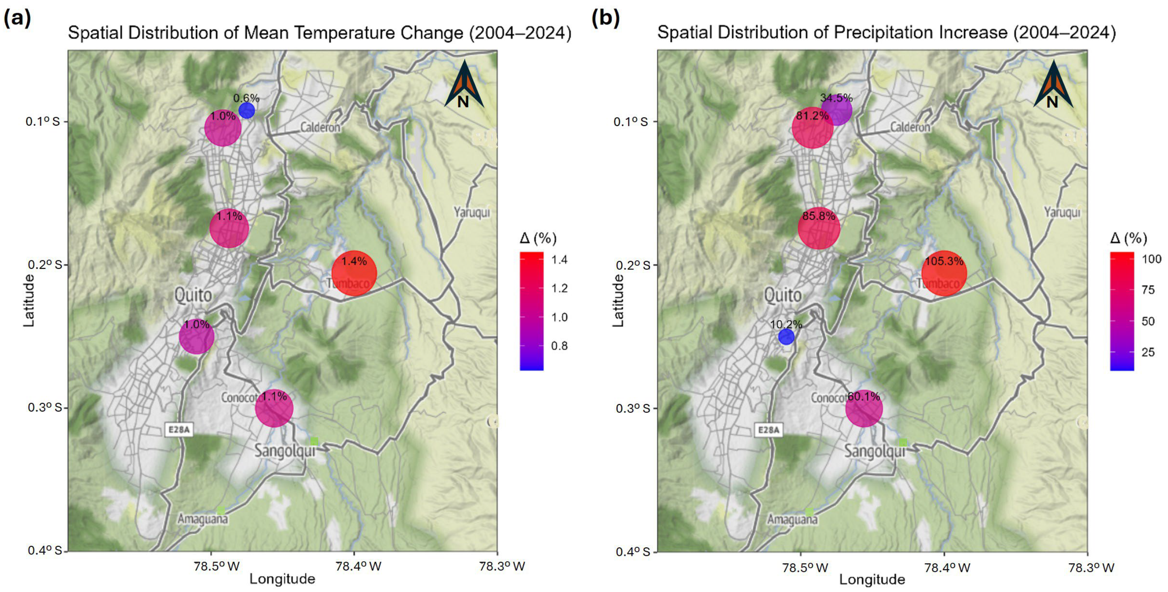
Despite these differences in baseline precipitation, the rates of increase vary substantially across stations (Figure A2, Appendix A). Over 2004–2024, (5) El Camal exhibited a moderate increase, Δ = 10.16% of the base trend, while (4) Tumbaco showed the largest relative increase, Δ = 105.32% (Figure 4 and Figure A2, Appendix A). (2) Cotocollao and (3) Belisario recorded notable increases of Δ = 81.20% and Δ = 85.80%, respectively, with (1) Carapungo rising by Δ = 34.55% and (6) Los Chillos by Δ = 60.08%, suggesting a recent shift from earlier trends driven by regional moisture dynamics. Such changes may be driven by urban-induced modifications to local moisture dynamics and convection [50]. The relatively small change at (5) El Camal, despite its high annual totals, could be due to its location combined with data limitations, whereas the larger increases at (6) Los Chillos and (3) Belisario reinforce the pattern of a wetter south-central gradient.
As revealed by STL trend decomposition, annual precipitation trends across Quito show clear spatial differences along with an overall increase in cumulative precipitation over the past 21 years. Some areas of Quito have experienced extraordinary increases in annual precipitation, nearly doubling over the past two decades. Such sharp rises are exceptional and may signal shifts in regional climate dynamics, urban-enhanced convection linked to higher temperatures [51,52], or amplified effects of ENSO variability. These trends have critical implications for flood risk, water infrastructure, and land-use planning. They underscore the urgency of integrating climate adaptation strategies into urban development, considering not only long-term precipitation changes but also event frequency and intensity through methods tailored to these highland zones [53].
Regionally, in the Northern Tropical Andes, recent studies have confirmed increases in the intensity and frequency of precipitation events over the past decade, strongly modulated by ENSO and exacerbated by climate change, which also introduces greater unpredictability [54]. Additional research has documented rising relative humidity trends in northern Ecuador and southern Colombia [55]. These results also support broader findings reported by the IPCC, which indicate with medium confidence that globally averaged precipitation over land has increased since 1950, with an accelerated rate of change since the 1980s [2].

3.3. El Niño Southern Oscillation Influence on Quito’s Temperature and Precipitation

Figure 3 illustrates the influence of ENSO events on local temperatures. Almost every El Niño year (marked by red symbols) corresponded to a new local temperature maximum, exceeding the long-term warming trend line. Conversely, La Niña years (blue symbols) generally showed cooler conditions, falling below the trend. While the inter-Andean region of the Ecuadorian Andes is characterized by pronounced diurnal temperature ranges, these variations, when averaged over days and months, result in relatively modest seasonal fluctuations. This suggests that more substantial interannual temperature variability is linked to global or regional climate phenomena, overlaid on longer-term warming trends associated with climate change. Temperature changes across the Andes have long been connected to ENSO dynamics, particularly through teleconnections with sea surface temperature anomalies in the central Pacific’s Niño 3.4 region, which are known to also influence drought conditions [56].
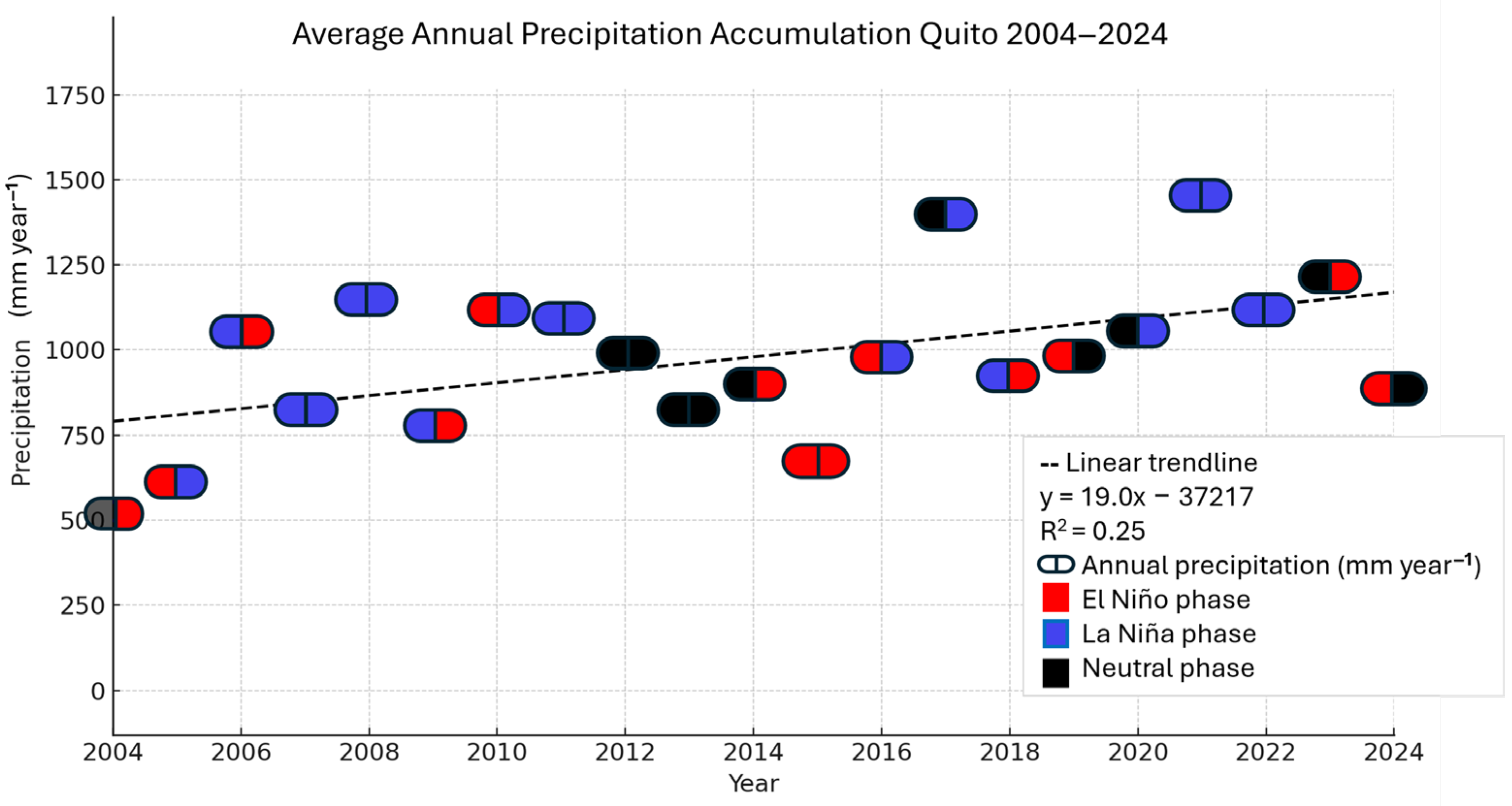
This pattern aligned with the well-established influence of ENSO on precipitation in the Andes, where El Niño typically reduces rainfall and La Niña enhances moisture availability [56] (Figure 5). In Quito, this variability has direct implications for water management: El Niño years may intensify wildfire risk and water scarcity in drier districts such as (4) Tumbaco, while La Niña phases can increase flood hazards, including landslides, debris flows, and urban flooding in wetter areas such as (5) El Camal and (6) Los Chillos. These findings underscore the need for adaptive strategies, favoring nature-based or hybrid solutions that address both long-term trends and ENSO-driven variability to build resilient urban planning and water systems.
In the Ecuadorian Andes, El Niño patterns were observed on glaciers on nearby volcanoes [57], as well as in the shifting elevations of glacier snow lines during different ENSO phases [58]. These relationships are driven by the propagation of El Niño conditions through the mid-troposphere, generating upper-level high-pressure systems that suppress rainfall and promote drought in the Andes [56]. Moreover, the recent 2023–2024 El Niño event highlighted these connections even more starkly, exhibiting pronounced anomalies in both precipitation and temperature patterns in the region [59,60] (Figure 3 and Figure 5). This may signal a trend toward more frequent and severe climate extremes in areas teleconnected to ENSO activity, including Ecuador and the broader South American tropics. Moreover, climate change may be amplifying the impacts of such events, prolonging thermal anomalies well beyond the typical lifespan of an El Niño episode [61]. In Ecuador, these compounded effects were evident in cities such as Quito, which faced heightened wildfire risks, hydroelectric power shortages, and increased strain on drinking water supplies [13].

3.4. Synthesis

In this work, we provide a uniquely detailed, multi-site analysis of temperature and precipitation trends within a high-elevation tropical capital on the equator, revealing patterns that exceed global urban averages in rapidly developing parts of the city. While previous studies in the Tropical Andes have focused on regional or altitudinal gradients or examined single stations over shorter timeframes, our work captures fine-scale intra-urban variability across various districts in Quito over two decades. It documents exceptional rates of minimum temperature increases—up to twice the global urban average—and localized precipitation rises exceeding 100%, underscoring the combined influence of rapid urban expansion, Andean topography, and teleconnections with ENSO events. By integrating high-resolution temporal and spatial data, this study not only fills critical observational gaps for northwestern South America but also highlights how the convergence of global climate change and unplanned urbanization can intensify climate impacts in tropical highland cities. These insights provide an essential foundation for designing localized adaptation and resilience strategies tailored to the unique challenges faced by rapidly growing equatorial metropolises. Results will also serve to inform Quito’s Climate Action Plan 2030 and urban greening initiatives aimed at mitigating UHI and flood risk.

4. Conclusions

This study reveals that tropical high-elevation cities such as Quito are experiencing profound and uneven climatic transformations, driven by the combined influence of global climate change, complex Andean topography, and rapid urbanization. Over 2004–2024, average temperatures in Quito rose by +0.95 °C (0.71 °C/decade), with minimum temperatures increasing by up to 2.57 °C (1.41 °C/decade) in some districts—roughly double global urban warming trends. These findings emphasize a pronounced Urban Heat Island effect, especially in rapidly expanding suburban areas where natural landscapes have been replaced by impervious surfaces.
Precipitation has also intensified, with several districts experiencing increases exceeding 80–100% over two decades, effectively doubling rainfall in some areas. Such sharp rises signal substantial changes in local hydroclimate and may reflect more frequent or intense extremes, although localized factors and data gaps remain.
The El Niño–Southern Oscillation continues to modulate interannual variability, with El Niño years bringing hotter, drier conditions and La Niña phases enhancing wetness and flood risk. The 2023/24 El Niño exemplifies how climate change may be amplifying these impacts, exacerbating droughts, water shortages, and wildfire risks.
The findings of this study stress the urgent need for high-resolution, site-specific climate assessments in tropical highland cities. Understanding how urbanization, topography, and global climate forces interact is essential for developing effective adaptation and resilience in similarly vulnerable regions.

Author Contributions

Conceptualization, R.Z., F.V., B.E. and O.C.; methodology, F.V. and R.Z.; software, R.Z., F.V., Y.R., D.M., S.B.-B. and T.I.T.-F.; validation, R.Z., F.V. and O.C.; formal analysis, F.V., R.Z. and Y.R.; investigation, R.Z., G.C., B.E. and F.V.; resources, R.Z.; data curation, R.Z., F.V., O.C. and Y.R.; writing—original draft preparation, R.Z., F.V. and G.C.; writing—review and editing, O.C., B.E., S.B.-B., D.M., Y.R. and T.I.T.-F.; visualization, R.Z., F.V., S.B.-B., D.M. and T.I.T.-F.; supervision, R.Z.; project administration, R.Z.; funding acquisition, R.Z. All authors have read and agreed to the published version of the manuscript.

Funding

This research was funded by Universidad de Las Americas, Ecuador, grant number AMB.RZ.23.01.

Institutional Review Board Statement

Not applicable.

Informed Consent Statement

Not applicable.

Data Availability Statement

The collected data is stored in the municipal administration’s repository, available for download at https://datosambiente.quito.gob.ec/ (accessed on 20 May 2025).

Acknowledgments

We are extremely grateful to Secretaria de Ambiente, DMQ, which has been a key player in collecting atmospheric and meteorological data, and especially Red Metropolitana de Monitoreo Atmosférico de Quito (REMMAQ). In this developing country, we are especially fortunate to have this amazing decades-long dataset, which is unique to our country and is a rare luxury in the whole continent.

Conflicts of Interest

The authors declare no conflicts of interest. The funders had no role in the design of the study; in the collection, analyses, or interpretation of data; in the writing of the manuscript; or in the decision to publish the results.

Appendix A

Figure A1. Satellite images of Quito, Ecuador, retrieved from Google Earth for: (a) 12/31/2002; (b) 12/31/2013; and (c) 1/1/2021–6/11/2024. Different satellite data were used to produce the maps: AirbusCNES/AirbusMaxar TechnologiesLandsat/Copernicus (c); Landsat/Copernicus (a,b) retrieved from: https://earth.google.com/web/@-0.1927554,-78.3637257,2472.83099683a,68795.46412996d,35y,0.09904646h,0t,0r/data=CgRCAggBOgMKATBCAggASg0I____________ARAA (accessed on 18 July 2025).
Atmosphere 16 01080 g0a1
Figure A2. Spatial distribution of climate trends (2004–2024) across six meteorological stations in Quito: (1) Carapungo, (2) Cotocollao, (3) Belisario, (4) Tumbaco, (5) El Camal, and (6) Los Chillos. (a) Increment in mean temperature (Δ, %). (b): Change in precipitation (Δ, %). Point size and color indicate the magnitude of change, with labels showing percentage values.
Atmosphere 16 01080 g0a2

References

  1. Sachs, J.; Kroll, C.; Lafortune, G.; Fuller, G.; Woelm, F. The Decade of Action for the Sustainable Development Goals: Sustainable Development Report 2021; Cambridge University Press: Cambridge, UK, 2021. [Google Scholar]
  2. Intergovernmental Panel for Climate Change. Climate Change 2021: The Physical Science Basis. Contribution of Working Group I to the Sixth Assessment Report of the Intergovernmental Panel on Climate Change; Cambridge University Press: Cambridge, UK, 2021. [Google Scholar]
  3. WMO Climate Change: A Threat to Human Wellbeing and Health of the Planet. 2022. Available online: https://wmo.int/media/news/climate-change-threat-human-wellbeing-and-health-of-planet (accessed on 4 February 2025).
  4. United Nations Day of 8 Billion. Available online: https://www.un.org/en/dayof8billion (accessed on 4 February 2025).
  5. United Nations. Population Division World Population Prospects 2022: Summary of Results | Population Division. Available online: https://www.un.org/development/desa/pd/content/World-Population-Prospects-2022 (accessed on 16 July 2025).
  6. National Oceanic & Atmospheric Administration (NOAA). Mauna Loa Observatory: Carbon Cycle Greenhouse Gases. Trends in CO2, CH4, N2O, SF6. Available online: https://gml.noaa.gov/ccgg/trends/ (accessed on 2 July 2025).
  7. NASA Global Temperature. Available online: https://climate.nasa.gov/vital-signs/global-temperature/?intent=121 (accessed on 4 February 2025).
  8. Intergovernmental Panel on Climate Change (IPCC). Weather and Climate Extreme Events in a Changing Climate. In Climate Change 2021—The Physical Science Basis: Working Group I Contribution to the Sixth Assessment Report of the Intergovernmental Panel on Climate Change; IPCC, Ed.; Cambridge University Press: Cambridge, UK, 2021; pp. 1513–1766. ISBN 9781009157889. [Google Scholar]
  9. NASA-Goddard Space Flight Center. Temperatures Rising: NASA Confirms 2024 Warmest Year on Record—NASA. Available online: https://www.nasa.gov/news-release/temperatures-rising-nasa-confirms-2024-warmest-year-on-record/ (accessed on 16 July 2025).
  10. Climate Change Information for Regional Impact and for Risk Assessment. In Climate Change 2021—The Physical Science Basis: Working Group I Contribution to the Sixth Assessment Report of the Intergovernmental Panel on Climate Change; IPCC, Ed.; Cambridge University Press: Cambridge, UK, 2021; pp. 1767–1926. ISBN 9781009157889.
  11. United Nations Country Profiles. Available online: https://population.un.org/wup/countryprofiles?country=Ecuador (accessed on 2 July 2025).
  12. Intergovernmental Panel on Climate Change (IPCC). Central and South America; IPCC, Ed.; Cambridge University Press: Cambridge, UK, 2023. [Google Scholar]
  13. Zalakeviciute, R.; Lopez-Villada, J.; Ochoa, A.; Moreno, V.; Byun, A.; Proaño, E.; Mejía, D.; Bonilla-Bedoya, S.; Rybarczyk, Y.; Vallejo, F. Urban Air Pollution in the Global South: A Never-Ending Crisis? Atmosphere 2025, 16, 487. [Google Scholar] [CrossRef]
  14. Marin, A.; Möhle, E.; Aneise, A.J. Environmental Crisis and Sustainable Development in South America. In Oxford Research Encyclopedia of Climate Science; Oxford University Press: Oxford, UK, 2025. [Google Scholar]
  15. Vanacker, V.; Armando, M.; Rossana, T.; Edison, C.; Cadilhac, L. Challenges for Research on Global Change in Mainland Ecuador. Neotrop. Biodivers. 2018, 4, 114–118. [Google Scholar] [CrossRef]
  16. Tapia-Armijos, M.F.; Homeier, J.; Espinosa, C.I.; Leuschner, C.; de la Cruz, M. Deforestation and Forest Fragmentation in South Ecuador since the 1970s—Losing a Hotspot of Biodiversity. PLoS ONE 2015, 10, e0133701. [Google Scholar] [CrossRef] [PubMed]
  17. Sun, Q.; Zhang, X.; Zwiers, F.; Westra, S.; Alexander, L. V A Global, Continental, and Regional Analysis of Changes in Extreme Precipitation. J. Clim. 2021, 34, 243–258. [Google Scholar] [CrossRef]
  18. Dunn, R.J.H.; Alexander, L.V.; Donat, M.G.; Zhang, X.; Bador, M.; Herold, N.; Lippmann, T.; Allan, R.; Aguilar, E.; Barry, A.A.; et al. Development of an Updated Global Land In Situ-Based Data Set of Temperature and Precipitation Extremes: HadEX3. J. Geophys. Res. Atmos. 2020, 125, e2019JD032263. [Google Scholar] [CrossRef]
  19. Vuille, M.; Francou, B.; Wagnon, P.; Juen, I.; Kaser, G.; Mark, B.G.; Bradley, R.S. Climate Change and Tropical Andean Glaciers: Past, Present and Future. Earth-Sci. Rev. 2008, 89, 79–96. [Google Scholar] [CrossRef]
  20. Vuille, M.; Bradley, R.S.; Werner, M.; Keimig, F. 20th Century Climate Change in the Tropical Andes: Observations and Model Results. Clim. Change 2003, 59, 75–99. [Google Scholar] [CrossRef]
  21. Hock, R.; Rasul, G.; Adler, C.; Cáceres, B.; Gruber, S.; Hirabayashi, Y.; Jackson, M.; Kääb, A.; Kang, S.; Kutuzov, S.; et al. High Mountain Areas. In IPCC Special Report on the Ocean and Cryosphere in a Changing Climate; Cambridge University Press: Cambridge, UK; New York, NY, USA, 2019. [Google Scholar]
  22. Reyer, C.P.O.; Adams, S.; Albrecht, T.; Baarsch, F.; Boit, A.; Canales Trujillo, N.; Cartsburg, M.; Coumou, D.; Eden, A.; Fernandes, E.; et al. Climate Change Impacts in Latin America and the Caribbean and Their Implications for Development. Reg. Environ. Change 2017, 17, 1601–1621. [Google Scholar] [CrossRef]
  23. Almazroui, M.; Ashfaq, M.; Islam, M.N.; Rashid, I.U.; Kamil, S.; Abid, M.A.; O’Brien, E.; Ismail, M.; Reboita, M.S.; Sörensson, A.A.; et al. Assessment of CMIP6 Performance and Projected Temperature and Precipitation Changes Over South America. Earth Syst. Environ. 2021, 5, 155–183. [Google Scholar] [CrossRef]
  24. World Meteorological Organization. State of the Climate in Latin America and the Caribbean 2024; WMO: Geneva, Switzerland, 2025. [Google Scholar]
  25. Instituto Nacional de Estadística y Censos (INEC). Boletín técnico N° 01-2021-IPT-IH-IR: Índice de Puestos de Trabajo (IPT), Índice de Horas Trabajadas (IH) e Índice de Remuneraciones (IR); Dirección de Estadísticas Económicas (DECON), Gestión de Indicadores Económicos (GIE), Sistema de Indicadores de la Producción (SIPRO): Quito, Ecuador, 2021; Available online: https://www.ecuadorencifras.gob.ec/ (accessed on 5 May 2025).
  26. Rybarczyk, Y.; Zalakeviciute, R.; Ereminaite, M.; Costa-Stolz, I. Causal Effect of PM2.5 on the Urban Heat Island. Front. Big Data 2025, 8, 1546223. [Google Scholar] [CrossRef]
  27. Sietsma, A.J.; Ford, J.D.; Callaghan, M.W.; Minx, J.C. Progress in Climate Change Adaptation Research. Environ. Res. Lett. 2021, 16, 054038. [Google Scholar] [CrossRef]
  28. Harvey, C.A.; Saborio-Rodríguez, M.; Martinez-Rodríguez, M.R.; Viguera, B.; Chain-Guadarrama, A.; Vignola, R.; Alpizar, F. Climate Change Impacts and Adaptation among Smallholder Farmers in Central America. Agric. Food Secur. 2018, 7, 57. [Google Scholar] [CrossRef]
  29. EMASEO. Municipio del Distrito Metropolitano de Quito: Plan de Desarrollo 2012–2022; EMASEO: Quito, Ecuador, 2011. [Google Scholar]
  30. MECN. Ecosistemas del Distrito Metropolitano de Quito (DMQ); Publicación Miscelánea No. 6; MECN: Quito, Ecuador, 2009. [Google Scholar]
  31. INEC. Ecuador Crecio En 2.5 Millones de Personas Entre 2010 y 2022. Available online: https://www.censoecuador.gob.ec/ecuador-crecio-en-2-5-millones-de-personas-entre-2010-y-2022/ (accessed on 6 January 2024).
  32. Zalakeviciute, R.; López-Villada, J.; Rybarczyk, Y. Contrasted Effects of Relative Humidity and Precipitation on Urban PM2.5 Pollution in High Elevation Urban Areas. Sustainability 2018, 10, 2064. [Google Scholar] [CrossRef]
  33. Zambrano-Barragán, C.; Zevallos, O.; Villacís, M.; Enríquez, D. Quito’s Climate Change Strategy: A Response to Climate Change in the Metropolitan District of Quito, Ecuador BT—Resilient Cities; Otto-Zimmermann, K., Ed.; Springer: Dordrecht, The Netherlands, 2011; pp. 515–529. [Google Scholar]
  34. Serrano Vincenti, S.; Zuleta, D.; Moscoso, V.; Jácome, P.; Palacios, E.; Villacís, M. Análisis estadístico de datos meteorológicos mensuales y diarios para la determinación de variabilidad climática y cambio climático en el Distrito Metropolitano de Quito. LA GRANJA. Rev. Cienc. Vida 2012, 16, 23–47. Available online: https://www.redalyc.org/pdf/4760/476047400004.pdf (accessed on 4 February 2025). [CrossRef]
  35. Parra, R.; Cadena, E.; Flores, C. Maximum UV Index Records (2010–2014) in Quito (Ecuador) and Its Trend Inferred from Remote Sensing Data (1979–2018). Atmosphere 2019, 10, 787. [Google Scholar] [CrossRef]
  36. Vallejo, F.; Yanez, D. Air Ecuador 2025. Available online: https://zenodo.org/records/15503706 (accessed on 5 May 2025).
  37. Carslaw, D.C.; Ropkins, K. Openair—An R Package for Air Quality Data Analysis. Environ. Model. Softw. 2012, 27–28, 52–61. [Google Scholar] [CrossRef]
  38. Lümkemann, N.; Klimenta, M.; Hoffmann, M.; Meinen, J.; Stawarczyk, B. Dimensional Stability and Reproducibility of Varying FFF Models for Aligners in Comparison to Plaster Models. Materials 2023, 16, 4835. [Google Scholar] [CrossRef]
  39. Hyndman, R.J.; Khandakar, Y. Automatic Time Series Forecasting: The Forecast Package for R. J. Stat. Softw. 2008, 27, 1–22. [Google Scholar] [CrossRef]
  40. Wickham, H. Ggplot2: Elegant Graphics for Data Analysis; Springer: New York, NY, USA, 2016; ISBN 978-3-319-24277-4. [Google Scholar]
  41. Liu, Z.; Zhan, W.; Bechtel, B.; Voogt, J.; Lai, J.; Chakraborty, T.; Wang, Z.-H.; Li, M.; Huang, F.; Lee, X. Surface Warming in Global Cities Is Substantially More Rapid than in Rural Background Areas. Commun. Earth Environ. 2022, 3, 219. [Google Scholar] [CrossRef]
  42. Mentaschi, L.; Duveiller Bogdan, G.H.E.; Zulian, G.; Corban, C.; Pesaresi, M.; Maes, J.; Stocchino, A.; Feyen, L. Global Long-Term Mapping of Surface Temperature Shows Intensified Intra-City Urban Heat Island Extremes. Glob. Environ. Change 2022, 72, 102441. [Google Scholar] [CrossRef]
  43. Yuan, Y.; Santamouris, M.; Xu, D.; Geng, X.; Li, C.; Cheng, W.; Su, L.; Xiong, P.; Fan, Z.; Wang, X.; et al. Surface Urban Heat Island Effects Intensify More Rapidly in Lower Income Countries. Urban Sustain. 2025, 5, 11. [Google Scholar] [CrossRef]
  44. Bonilla-Bedoya, S.; Mora, A.; Vaca, A.; Estrella, A.; Herrera, M.Á. Modelling the Relationship between Urban Expansion Processes and Urban Forest Characteristics: An Application to the Metropolitan District of Quito. Comput. Environ. Urban Syst. 2020, 79, 101420. [Google Scholar] [CrossRef]
  45. Smith, I.A.; Fabian, M.P.; Hutyra, L.R. Urban Green Space and Albedo Impacts on Surface Temperature across Seven United States Cities. Sci. Total Environ. 2023, 857, 159663. [Google Scholar] [CrossRef] [PubMed]
  46. Li, Y.; Svenning, J.-C.; Zhou, W.; Zhu, K.; Abrams, J.F.; Lenton, T.M.; Ripple, W.J.; Yu, Z.; Teng, S.N.; Dunn, R.R.; et al. Green Spaces Provide Substantial but Unequal Urban Cooling Globally. Nat. Commun. 2024, 15, 7108. [Google Scholar] [CrossRef]
  47. Bowler, D.E.; Buyung-Ali, L.; Knight, T.M.; Pullin, A.S. Urban Greening to Cool Towns and Cities: A Systematic Review of the Empirical Evidence. Landsc. Urban Plan. 2010, 97, 147–155. [Google Scholar] [CrossRef]
  48. Pinto, M. Análisis de Los Procesos de Expansión Urbana en Quito y Bogotá a Través del Diseño de Políticas Públicas. Ph.D. Thesis, Universidad de Cuenca, Cuenca, Ecuador, 2024. [Google Scholar]
  49. Carrión, F.; Espinosa-Erazo, J. La Forma Urbana de Quito: Una Historia de Centros y Periferias. Bull. l’Institut Français d’Études Andin. 2012, 41, 503–522. [Google Scholar] [CrossRef]
  50. Shepherd, J.M. A Review of Current Investigations of Urban-Induced Rainfall and Recommendations for the Future. Earth Interact. 2005, 9, 1–27. [Google Scholar] [CrossRef]
  51. Minobe, S.; Behrens, E.; Findell, K.L.; Loeb, N.G.; Meyssignac, B.; Sutton, R. Global and Regional Drivers for Exceptional Climate Extremes in 2023-2024: Beyond the New Normal. npj Clim. Atmos. Sci. 2025, 8, 138. [Google Scholar] [CrossRef]
  52. Geng, X.; Kug, J.-S.; Shin, N.-Y.; Zhang, W.; Chen, H.-C. On the Spatial Double Peak of the 2023–2024 El Niño Event. Commun. Earth Environ. 2024, 5, 691. [Google Scholar] [CrossRef]
  53. Escobar-González, D.; Singaña-Chasi, M.S.; González-Vergara, J.; Erazo, B.; Zambrano, M.; Acosta, D.; Villacís, M.; Guallpa, M.; Lahuatte, B.; Peluffo-Ordóñez, D.H. Intensity-Duration-Frequency Curve for Extreme Rainfall Event Characterization, in the High Tropical Andes. Water 2022, 14, 2998. [Google Scholar] [CrossRef]
  54. Poveda, G.; Espinoza, J.C.; Zuluaga, M.D.; Solman, S.A.; Garreaud, R.; van Oevelen, P.J. High Impact Weather Events in the Andes. Front. Earth Sci. 2020, 8, 162. [Google Scholar] [CrossRef]
  55. Martinez, R.; Ruiz Carrascal, D.; Andrade, M.; Blacutt, L.; Pabón Caicedo, J.D.; Jaimes, E.; Gloria, L.; Villacis, M.; Quintana, J.; Montealegre, E. Synthesis of the Climate of the Tropical Andes. In Climate Change and Biodiversity in the Tropical Andes; Inter-American Institute of Global Change Research (IAI): Montevideo, Uruguay, 2011; ISBN 9788599857056. [Google Scholar]
  56. Vicente-Serrano, S.M.; Aguilar, E.; Martínez, R.; Martín-Hernández, N.; Azorin-Molina, C.; Sanchez-Lorenzo, A.; El Kenawy, A.; Tomás-Burguera, M.; Moran-Tejeda, E.; López-Moreno, J.I.; et al. The Complex Influence of ENSO on Droughts in Ecuador. Clim. Dyn. 2017, 48, 405–427. [Google Scholar] [CrossRef]
  57. Francou, B.; Vuille, M.; Favier, V.; Cáceres, B. New Evidence for an ENSO Impact on Low-Latitude Glaciers: Antizana 15, Andes of Ecuador, 0°28′S. J. Geophys. Res. Atmos. 2004, 109, D18106. [Google Scholar] [CrossRef]
  58. Veettil, B.K.; Leandro Bayer Maier, É.; Bremer, U.F.; de Souza, S.F. Combined Influence of PDO and ENSO on Northern Andean Glaciers: A Case Study on the Cotopaxi Ice-Covered Volcano, Ecuador. Clim. Dyn. 2014, 43, 3439–3448. [Google Scholar] [CrossRef]
  59. Ramanathan, V. The Role of Ocean-Atmosphere Interactions in the CO2 Climate Problem. J. Atmos. Sci. 1981, 38, 918–930. [Google Scholar] [CrossRef]
  60. Roca, R.; Fiolleau, T. Extreme Precipitation in the Tropics Is Closely Associated with Long-Lived Convective Systems. Commun. Earth Environ. 2020, 1, 18. [Google Scholar] [CrossRef]
  61. Jiang, N.; Zhu, C.; Hu, Z.-Z.; McPhaden, M.J.; Chen, D.; Liu, B.; Ma, S.; Yan, Y.; Zhou, T.; Qian, W.; et al. Enhanced Risk of Record-Breaking Regional Temperatures during the 2023–24 El Niño. Sci. Rep. 2024, 14, 2521. [Google Scholar] [CrossRef] [PubMed]
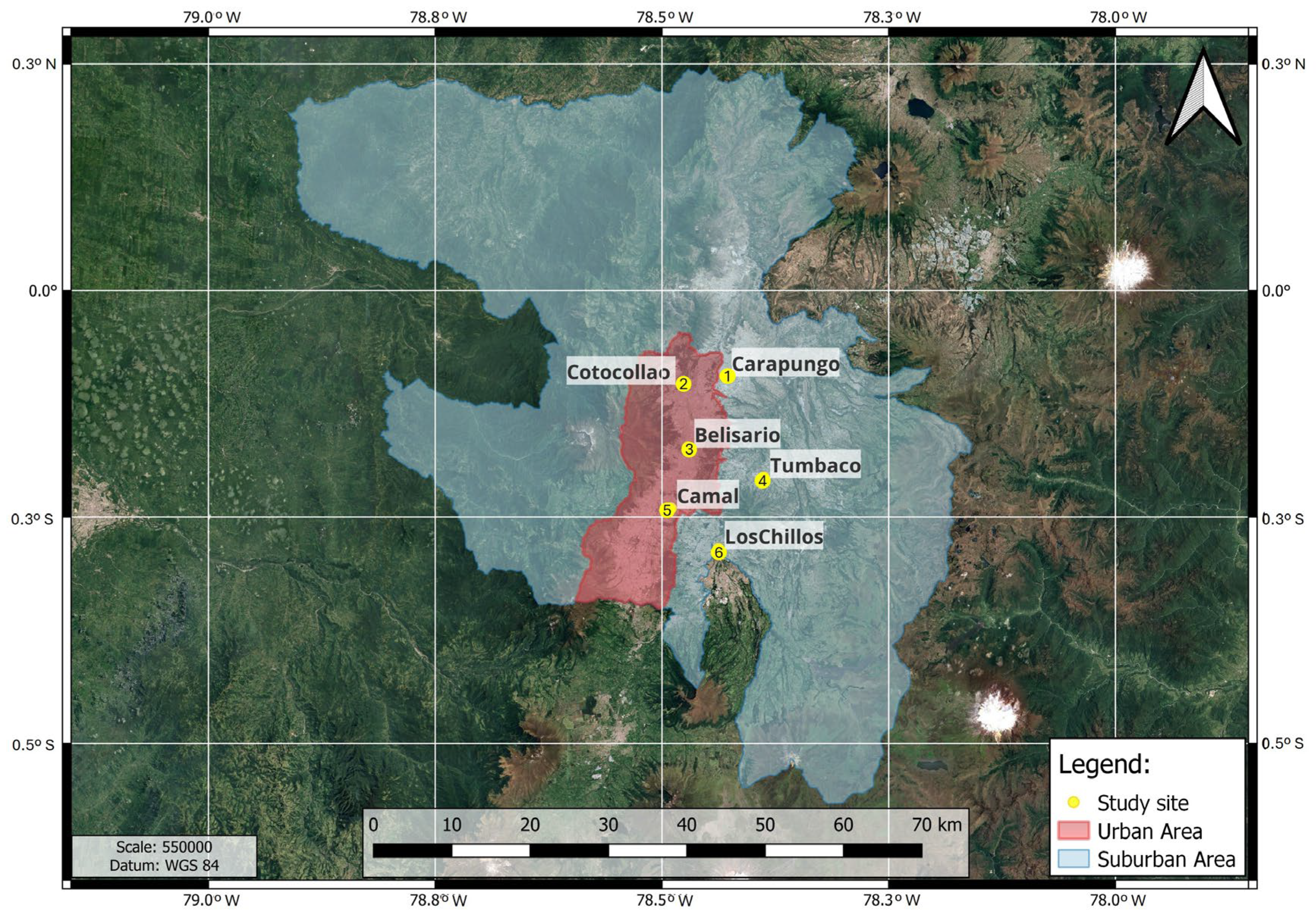
Figure 1. Study sites: (1) Carapungo; (2) Cotocollao; (3) Belisario; (4) Tumbaco; (5) El Camal; and (6) Los Chillos in the metropolitan district of Quito (urban—red shaded area and suburban—grey shaded area).
Atmosphere 16 01080 g001
Figure 2. Monthly temperature trends from 2004 to 2024 for six meteorological stations in Quito: (1) Carapungo (Panel a); (2) Cotocollao (Panel b); (3) Belisario (Panel c); (4) Tumbaco (Panel d); (5) El Camal (Panel e); (6) Los Chillos (Panel f). Maximum (red), minimum (blue), and mean (black) temperatures are shown as raw monthly data (thin lines) with their respective trend lines (thick lines—STL-based model).
Atmosphere 16 01080 g002
Figure 3. Average annual temperature for 2004–2024, calculated from six sites in Quito. The colors indicate an approximation of ENSO cycle phases over the 12-month duration of that year: red represents El Niño, blue represents La Niña, and black represents neutral conditions. El Niño ONI 3.4 v5 phases (right axis) were retrieved from the NOAA website: https://origin.cpc.ncep.noaa.gov/products/analysis_monitoring/ensostuff/ONI_v5.php (accessed on 5 May 2025).
Atmosphere 16 01080 g003
Figure 4. Annual and monthly precipitation trends in Quito (2004–2024) by station: (1) Carapungo (Panel a); (2) Cotocollao (Panel b); (3) Belisario (Panel c); (4) Tumbaco (Panel d); (5) El Camal (Panel e); (6) Los Chillos (Panel f). Solid lines: Monthly sums; Columns: Annual totals; Dashed lines: Trend (STL decomposition). Annotations indicate the total change (Δ) in precipitation over the study period.
Atmosphere 16 01080 g004
Figure 5. Average annual cumulative precipitation for 2004–2024, averaged over all study sites in Quito, Ecuador. The colors indicate an approximation of ENSO cycle phases over the 12-month duration of that year: red represents El Niño, blue represents La Niña, and black represents neutral conditions. El Niño ONI 3.4 v5 phases were retrieved from the NOAA website: https://origin.cpc.ncep.noaa.gov/products/analysis_monitoring/ensostuff/ONI_v5.php (accessed on 5 May 2025).
Atmosphere 16 01080 g005
Disclaimer/Publisher’s Note: The statements, opinions and data contained in all publications are solely those of the individual author(s) and contributor(s) and not of MDPI and/or the editor(s). MDPI and/or the editor(s) disclaim responsibility for any injury to people or property resulting from any ideas, methods, instructions or products referred to in the content.