Article

Unfavorable Local Meteorological Conditions in the Vicinity of the Planned Nuclear Power Plant in Jordan

1
Department of Basic Sciences, National University College of Technology, Amman 11131, Jordan
2
Department of Aviation Sciences, Amman Arab University, Amman 11941, Jordan
3
Environmental and Aerosol Research Laboratory (EARL), Department of Physics, School of Science, The University of Jordan, Amman 11942, Jordan
4
Niels Bohr Institute (NBI), University of Copenhagen, 1172 Copenhagen, Denmark
5
Institute for Atmospheric and Earth System Research (INAR/Physics), Faculty of Science, University of Helsinki (UHEL), PL 64, FI-00014 Helsinki, Finland
*
Author to whom correspondence should be addressed.
Atmosphere 2025, 16(10), 1215; https://doi.org/10.3390/atmos16101215
Submission received: 22 August 2025 / Revised: 6 October 2025 / Accepted: 18 October 2025 / Published: 20 October 2025
(This article belongs to the Section Meteorology)

Abstract

The development of nuclear energy in Jordan necessitates a detailed understanding of local meteorological behavior, particularly during unfavorable weather conditions. This study uses the METEO mesoscale model to simulate wind fields, vertical motions, and surface–air temperature differences under unfavorable wind directions (15°, 105°, and 195°) and two wind speeds (1 m/s and 5 m/s), across cold season (January) and warm season (July), near the Samra Energy Power Plant (SEPP)—a proposed location for Jordan’s nuclear plant. Simulations reveal that low wind speeds create stable atmospheric layers with limited vertical motion (±0.1 m/s), enhancing the risk of pollutant accumulation in valleys. Higher wind speeds promote vertical mixing (up to ±0.15 m/s) and lower temperature gradients (within ±0.2 °C), dispersing pollutants more efficiently. These results suggest that specific wind thresholds could determine the spatial extent of emergency response zones, including “shelter-in-place” areas and evacuation perimeters. This study offers valuable insights for nuclear safety planning and environmental risk assessment in complex terrain.

1. Introduction

Ionizing radiation risk must be assessed and controlled without unduly limiting nuclear power plant (NPP) contributions to equitable and sustainable development. An appropriate decision-making strategy based on a quick and accurate estimation of air pollutant (such as radionuclide) dispersion should be used to mitigate the harmful effects of any unintentional release [1,2,3]. Decision making in high-risk scenarios is challenging, particularly when timely information is lacking. As a result, it is necessary to conduct progressive model development and extensive dispersion test simulations. Indicators used to measure risk and susceptibility include geophysical characteristics based on the location of NPP and population of the study region, probability, methodologies, and modeling techniques. A model of the radionuclide’s atmospheric transport, dispersion, and dry and wet deposition, as well as its accumulated total deposition over a lengthy period can be utilized [4,5,6,7,8,9,10,11,12,13,14,15,16,17,18,19,20].
Concerning NPP developments, it is critical to consider Energy Information Administration (EIA) research in case of future possible accidents for establishing action plans to avoid or adapt to nuclear radiation and related atmospheric transport near the NPP on a local or larger scale [4,9,15,18,19,20,21]. When a severe accident at NPP occurs, iodine is one of the components that can be harmful to workers, nearby areas, and the environment [7]. Lagrangian models may employ high spatial resolution even if they rely on interpolation of meteorological data. For instance, ref. [22] used an isentropic trajectory model to estimate how radionuclides may spread from a hypothetical nuclear accident in Northern Russia over Europe and Scandinavia [22]. Although atmospheric trajectories are divided, the dispersion model projected increased deposition in places that were not anticipated previously [6]. Also in southern Poland, the Global Environmental Multiscale-Air Quality (GEM-AQ) model was used to investigate the effect of globalization on meteorological conditions and the degree of pollution in the air [23].
The atmospheric transport and residence time of radionuclides at various altitudes might vary greatly. As a result, the likelihood of air parcels from the accident being carried to other geographical regions, as well as the period of their movement, can be examined at various altitudes using 3D trajectories [7]. In the case of a nuclear accident, an isentropic trajectory model can also be applied to estimate radioactive transport and contamination [22]. The estimation of the long-term consequences for population after an accident can be performed by empirical models, and a correlation between fallout and doses to humans can be calculated [4]. Researchers have also focused on studying the impact of nuclear accidents on water turbidity, which is important in understanding the broader environmental impact of nuclear accidents, especially in regions close to nuclear power plants, where radiation and pollution are most likely to spread. particularly in coastal regions [24].
Recently, the inclusion of nuclear power was recommended as part of Jordan’s national energy mix. An investigation of meteorological conditions and mass transfer has not previously been addressed in non-prevailing wind scenarios. The variabilities of horizontal and vertical wind components and surface temperature differences have been investigated near one of the originally suggested locations for the construction of an NPP facility (the Samra Energy Power Plant, SEPP; 32.1443° N & 36.1428° E & 560 m above sea level, m asl). The wind direction near the surface was established by the complexity of the surrounding terrain independent of the input values of the predominant wind direction in the simulation model domain, which has a size of 85 × 85 km2 in the surrounding area. For case [24], summarized in Table S3, and the input model parameters listed in Tables S1 and S2 in the Supplementary Materials, the monthly average prevailing WD was between 226° and 321°, except for November and December when it was mainly between 145°and 188°. The monthly average wind speed was between 1 m/s (winter) and 1.9 m/s (summer). In practice, these wind speed conditions defined the favorable meteorological conditions. The results reported there can serve as a base block for considering other possible locations for the construction of the NPP. However, further investigations are needed too, such as unfavorable weather conditions and their impact on the atmospheric transport and dispersion of pollution around the power plant. Here, unfavorable refers to the conditions that are seldom compared to the favored conditions, as will be defined later in the Methods section.
In this paper, we utilized a 3D mesoscale model of the atmospheric thermodynamics and radionuclide transport to simulate meteorology from the SEPP location (hereafter, the Jordanian Nuclear Power Plant, JNPP). Here, we illustrate the impacts of unfavorable local meteorological conditions during different seasons and wind speed conditions. The results anticipated from this investigation combined with [25] will give us an insight into the complete picture of possible risk during the JNPP’s operation. This will also help in strategic planning during possible/hypothetical nuclear crises at the JNPP.

2. Methodology

2.1. Jordan’s Geography

The geography of Jordan is diverse. Jordan mainly consists of a plateau ranging from 700 m to 1200 m in elevation, divided into ridges by valleys and gorges, and a few mountainous areas. Nearly all of Jordan’s landmass is desert. The climate in Jordan is characterized by a long, hot, and dry summer, usually extending from May to November, and a short cold winter, usually from December to February. The climate is influenced by Jordan’s location between the subtropical aridity of the Arabian desert areas and the subtropical humidity of the eastern Mediterranean area [26].
The summer daytime temperature averages around +33 °C but can surpass +40 °C. The Jordan Valley is perpetually hotter. Jordanian winters are quite cold, with occasional snowfall. While the average daily temperature in winter is around +13 °C, it often drops to zero or below, particularly at night, when frost forms. About 70% of the average rainfall in the country falls between November and March; June through August are often rainless. Precipitation is often concentrated in violent storms, causing erosion and local flooding, especially in the winter months [26].

2.2. Description of the Meteorological Model

Due to the enhanced resolution of numerical local meteorological prediction models, urban meteorology and air pollution processes can now be treated more realistically. This has sparked a renewed interest in modeling and experimentally describing the distinctive features and processes of urban areas. The METEO-TRANS modelling system [22,25], as a Model Package (MP), contains a numerical meso-meteorological model (METEO) over complex terrain as well as a Eulerian model for radioactive pollution atmospheric transport, dispersion, and deposition (TRANS) of radionuclides released from a hypothetical accident.
In our study, we utilized a modified version of the Model Package (MP). It was modified and prepared to accommodate the typical Jordanian conditions of the complex terrain, as summarized in Tables S1–S3. Model realizations of pollution distribution based on the determination of both the u, v, w-components of wind field U and coefficients of turbulent diffusion K along the x, y, and z-directions are used in numerical simulations of atmospheric pollution transport processes and diffusion. Wind fields can be determined using a combination of objective analysis of meteorological data from a meteorological measurement network and mathematical modeling of the atmospheric boundary layer’s hydro-thermodynamical properties. Using flexible architecture, the model may simulate both accidental emissions from sources and air pollution. The model describes radioactive horizontal dispersion using a structured square grid framework. A parameterized description within the tropospheric boundary layer is used for vertical radionuclides.
The model domain used in simulations covers a central part of the JNPP region, which means that there are 17 × 17 grid points (with a horizontal resolution of 5 km) corresponding to a domain size of 85 × 85 km2. There are 13 vertical layers (covering 1300 m), which have a depth ranging from 50 m—for 1–5th layers, 75 m—6th, 100 m—7th, 125 m—8th, to 150 m—9–13th layers (see Table S1 in Supplementary Materials). Vertical levels were determined based on assumed isothermal stratification in a hypothetical air column. During model simulations, atmospheric transport, dispersion, deposition and radioactive decay processes are considered.
The METEO model can simulate a 3D mean wind field, a vertical component of wind velocity with a variety of turbulence parameterization available and temperature within the terrain. There are several input variables needed for the model runs, as shown in Table S2 in Supplementary Materials. These include the terrain and content parameter’s location of the Samra EPP in the selected model domain; plant characteristics; operation mode parameters; temporal parameters related to the occurrence of a hypothetical release; a series of meteorological parameters; and numerical parameters. The METEO simulations provide 3D arrays that represent the wind and turbulence fields in the y-latitude, x-longitude and z-altitude directions as well as the temperature differences inside the terrain after a hypothetical release occurred.

2.3. Case Study and Simulation Scenarios

In this study, we performed a series of METEO model simulations for the location of the JNPP (which coincides with the SEPP location as one of the previously suggested locations to construct the JNPP) and its surrounding domain (Figure S1). Here, the simulations included unfavorable conditions for the wind directions (WD: 15, 105, and 195°), which were opposite to the favorable wind direction, but with two (1 and 5 m/s) wind speeds reflecting real (low wind) vs. moderate wind conditions (Table 1). Two months reflecting the winter (e.g., January) and the summer (e.g., July) seasons were considered. Other input parameters for the METEO model were taken according to the favorable conditions (Tables S1–S3 in the Supplementary Material).

3. Results

The simulations were carried out with three unfavorable wind directions (WD: 15, 105, and 195°) and two wind speed (1 and 5 m/s) scenarios. These simulations were carried out for two months—cold (January) and warm (July)—to represent seasonal extremes. The aim was to assess how these unfavorable meteorological conditions will impact each of the following: wind flow patterns, vertical mixing, and surface temperature distribution in a particular geographical area, e.g., at the JNPP or at the Samra site. Unfavorable WDs were chosen to be the opposite of the favorable ones which were from the northwest or southwest.

3.1. Low Wind Speed (1 m/s)

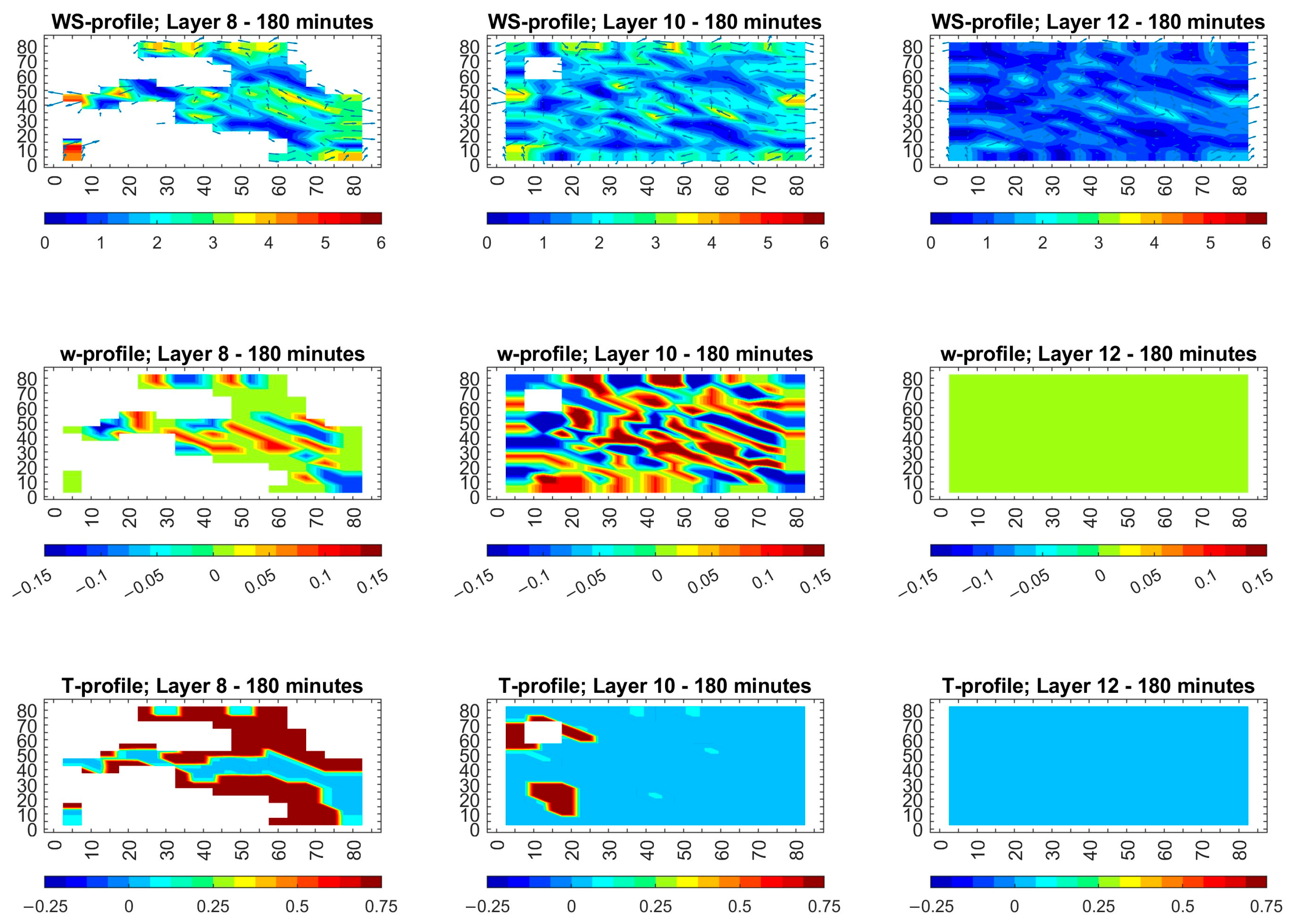
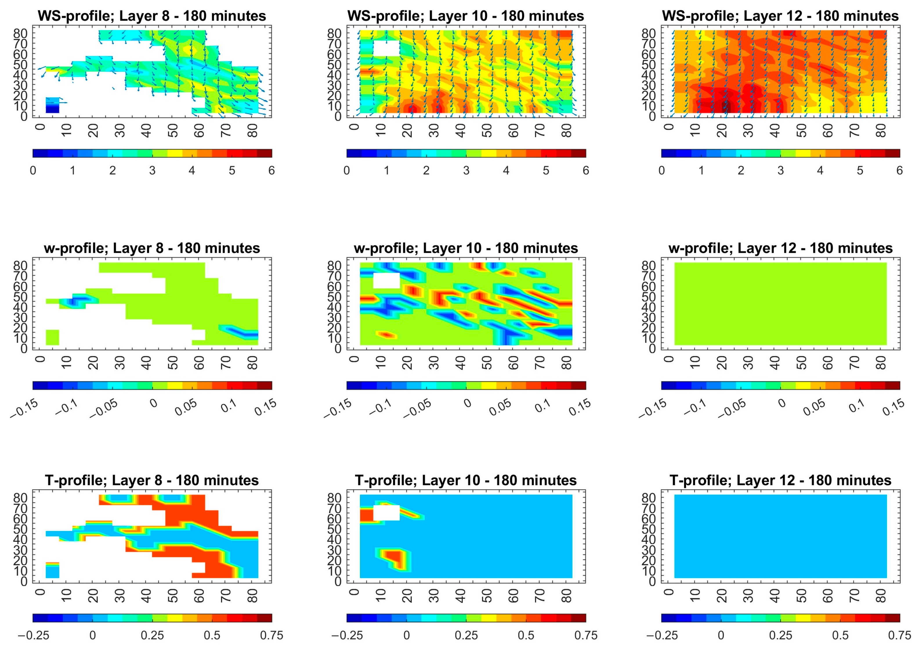
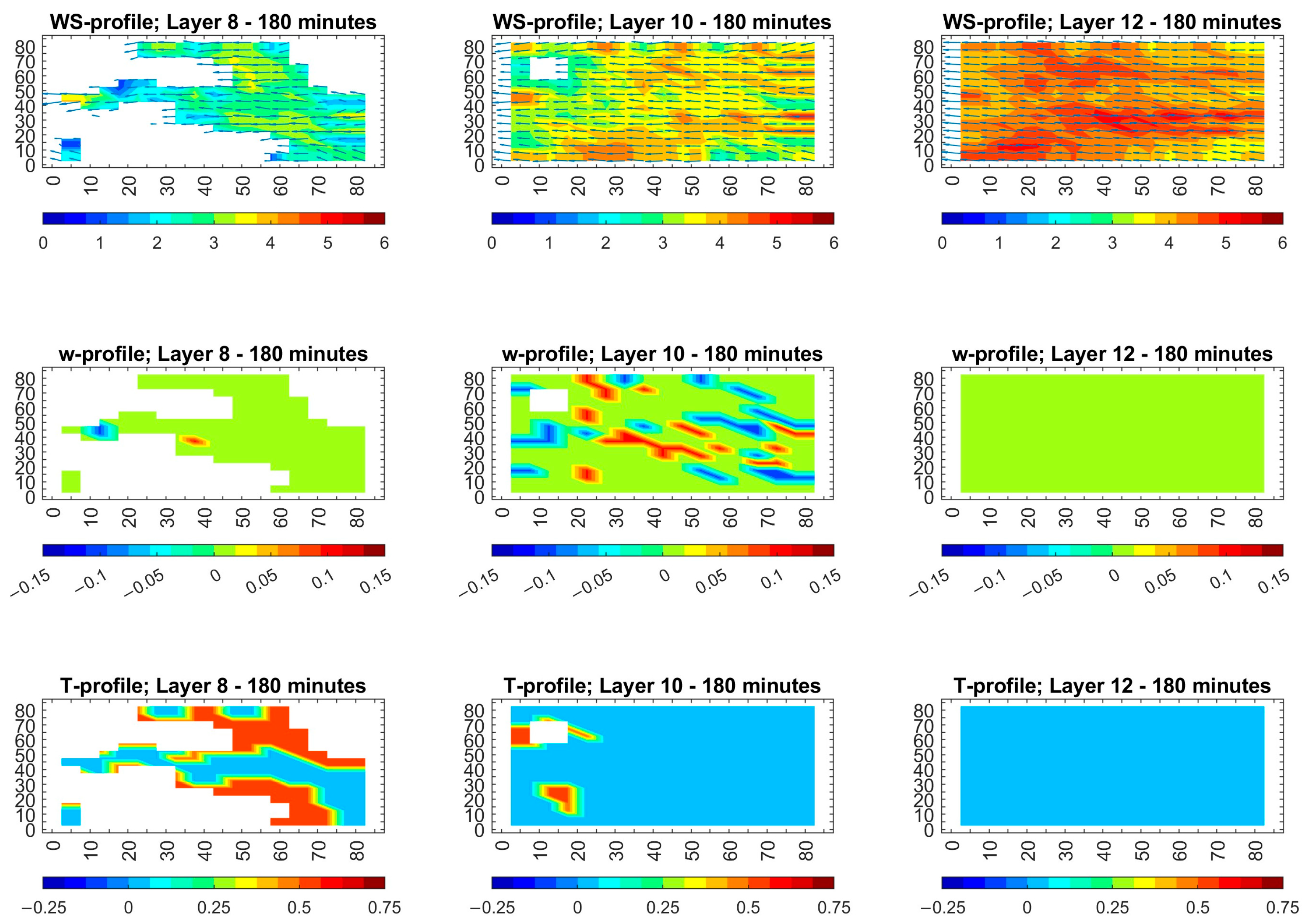
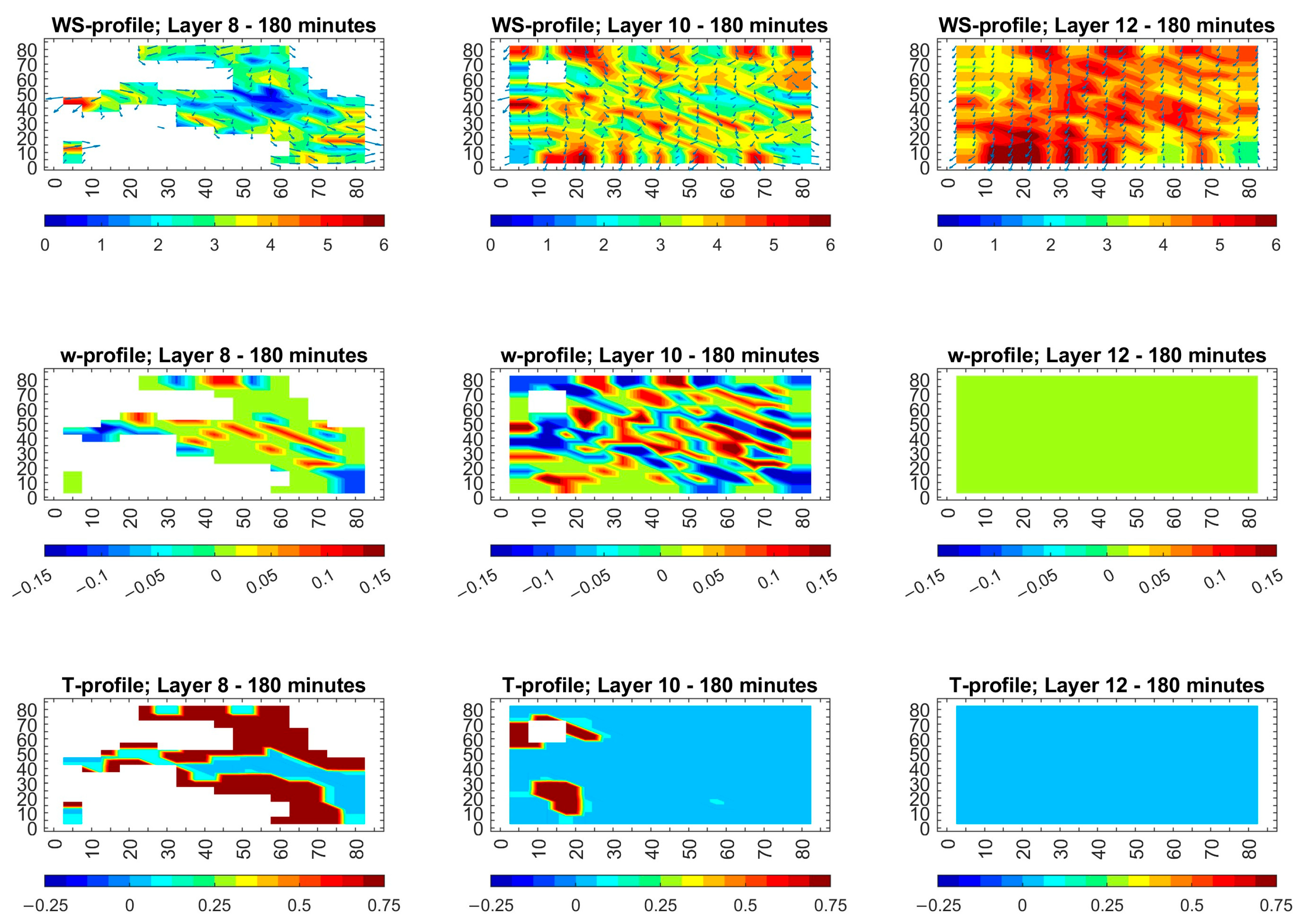
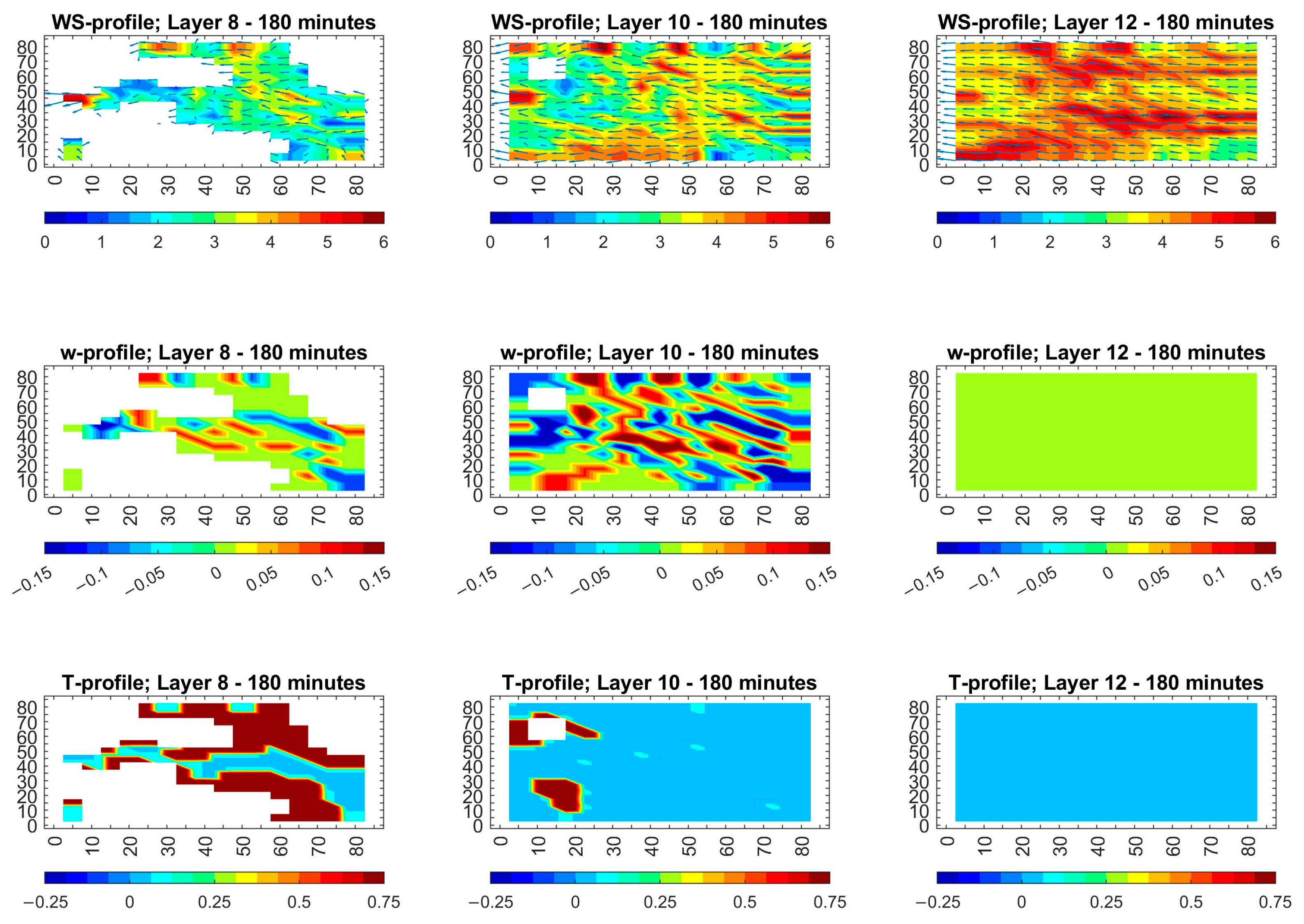
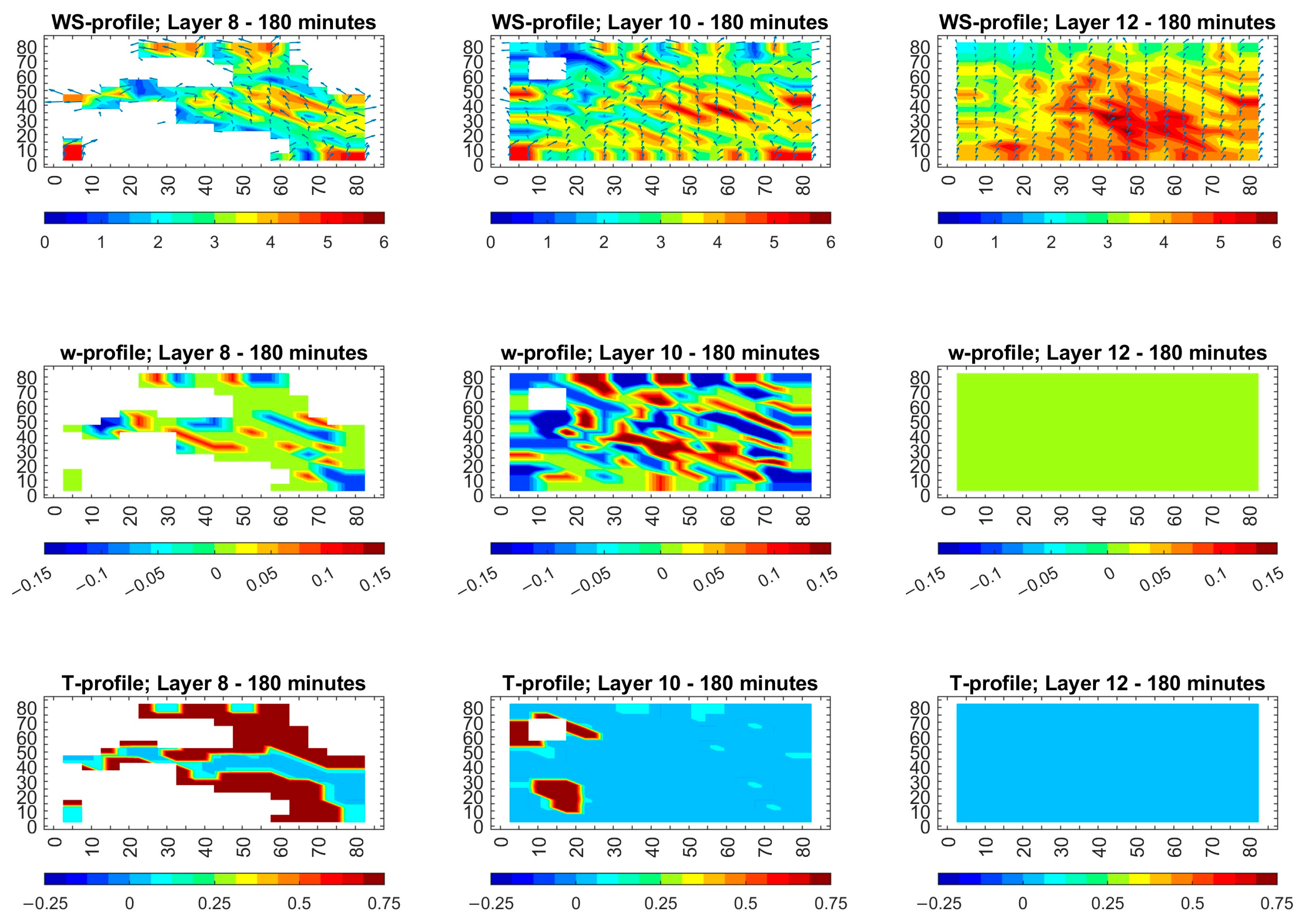
The results of local meteorological simulations after 180 min (3 h) under unfavorable wind conditions for WDs (15, 105 and 195°) for 1 m/s wind speed in the cold season (January) are shown in Figure 1, Figure 2 and Figure 3. Similarly, Figure 4, Figure 5 and Figure 6 show the results under the same conditions in the warm season (July). Each figure is structured in three rows of subplots. The upper row includes horizontal wind speed fields over terrain for three different atmospheric layers: Layer 8 (L8) (425–550 m asl), Layer 10 (L10) (700–850 m asl), and Layer 12 (L12) (1000–1150 m asl). The middle row illustrates the vertical wind velocity (vertical motion) profiles, and the bottom row shows the temperature difference profiles.

3.1.1. Low Wind Speed (1 m/s) in the Cold Season—January

In these conditions, the upper row of Figure 1, Figure 2 and Figure 3 show that the horizontal wind speeds in L8 remain low while showing localized wind acceleration in narrow zones which occur in valleys and between hills. The results show areas of varying wind speed, with a clear distinction between lower and higher values, indicating spatial heterogeneity in wind flow near the ground. The narrow zones reach wind speeds of about 2–3 m/s because of terrain acceleration effects. These zones present different patterns of wind acceleration which change depending on the wind direction. L10 exhibits a more uniform distribution of wind speeds compared to L8, suggesting less influence from surface features at this height, while L12 presents a largely consistent wind speed profile, indicating that wind flow becomes more stable at higher altitudes. For 15° WD, as seen in Figure 1, the flow is smoother, and acceleration zones are limited and weak. For 105° WD, as seen in Figure 2, stronger interaction between wind and terrain appears most prominently along slope areas, leading to more extensive channeling effects. For 195° WD, as seen in Figure 3, the wind encounters terrain more directly, leading to more focused and intense acceleration zones, with clearer wind deflection. The wind shows increased stability and smoothness with rising altitude, while terrain effects become less significant. The direction of wind plays a major role in determining how terrain influences flow patterns in lower layers, because the 195° WD (Figure 3) demonstrates the strongest terrain effects and the 15° WD (Figure 1) shows the weakest effects.
The vertical air motion remains weak across all three wind directions and generally varies within ±0.15 m/s. This reflects a stable atmospheric state with limited vertical mixing, which restricts the upward transport and dispersion of pollutants. Localized areas of upward and downward motion are observed; L8 displays significant variations in vertical wind velocity, with both upward and downward movements, consistent with turbulent mixing near the surface. L10 shows less pronounced vertical movements than L8 but still indicates some areas of upward and downward air currents, and L12 appears largely green, indicating near-zero vertical wind velocity, suggesting stable atmospheric conditions at this level. The variation in wind direction leads to noticeable differences in vertical motion. For 15° WD, the weakest vertical motions are observed (from −0.05 m/s to +0.1 m/s), indicating minimal interaction with the terrain. However, for 105° WD, the vertical motion range is slightly increased (from −0.05 m/s to +0.15 m/s), suggesting some terrain-induced channeling. For 195° WD, the most significant vertical motion changes are observed (about ±0.15 m/s), due to stronger interaction with opposing terrain features. These results highlight that wind direction plays a key role in shaping the vertical structure of airflow and the potential dispersion of pollutants in complex terrain conditions. The uppermost layer in the middle row of (Figure 1, Figure 2 and Figure 3) appears as a pale color, which shows that vertical motions are either very weak or close to zero. At this altitude, the surface terrain has very limited or negligible effects on the atmosphere, and the atmosphere is very stable, especially under cold-season conditions with light surface winds (1 m/s).
The bottom rows of the (Figure 1, Figure 2 and Figure 3) show that the surface–air temperature differences (ΔT) in the cold season and low-wind-speed (1 m/s) conditions vary between −0.25 °C and +0.75 °C. As seen in these figures, there is an identical pattern for all three WDs, indicating that wind direction has little effect on the overall ΔT distribution. L8 reveals distinct temperature variations, with some areas indicating higher temperatures (red) and others lower temperatures (blue), likely influenced by surface energy exchanges. L10 shows a more uniform temperature distribution than L8, with a predominance of cooler temperatures, while L12 displays a consistently cool temperature profile, indicating a stable temperature regime at this altitude. The maximum temperature differences appear in the lowest atmospheric layer extending from 425 to 550 m, and these differences decrease with height until reaching zero at approximately 1 km. The vertical decrease in ΔT underlines how the surface influence quickly disappears, while the upper boundary layer becomes well mixed and isothermal during calm winter conditions.
The summary key findings for the cold season (January) and low wind speed (1 m/s) are the following. The near-surface form narrows 2–3 m/s channels which move based on wind direction (the weakest for 15° WD, and the strongest for 195° WD), while vertical motions remain very small (from −0.05 to 0.15 m/s) with maximum values in the mid-layer and minimum values above 1 km indicating a highly stable atmosphere. The temperature differences extend from −0.25 to +0.75 °C, with the largest values observed in the lowest layer and disappearing at 1 km height regardless of the wind directions. The combination of atmospheric conditions creates pollutant corridors near the ground which restrict both horizontal and vertical dispersion of pollution, thus resulting in elevated local concentrations.

3.1.2. Low Wind Speed (1 m/s) in the Warm Season—July

For this condition, the first row of 5–7 shows that the horizontal wind speed changes are slightly more pronounced in the warm season than in the cold season. L8 displays short irregular horizontal winds (see arrows/vectors of wind speeds) that follow valley and ridge contours at speeds of about 1–2 m/s because of the strong terrain steering. In L10, horizontal wind speeds extend slightly (about 2–3 m/s) while pointing more in the direction of the mean flow, but small eddies continue to exist behind hills. L12 shows uniform flow (seen as parallel arrows/vectors of wind speeds), which is a steady 1–2 m/s air flow that remains free from terrain effects. The upper atmospheric layers develop these consistent horizontal flow patterns, because mechanical mixing with height reduces local terrain impacts under the light wind conditions of warm season. The observed pattern exists for all the three wind directions.
The vertical motions in the warm season, as seen in the middle row maps of Figure 4, Figure 5 and Figure 6), reached ±0.15 m/s, which exceeds the cold season values (Figure 1, Figure 2 and Figure 3). They were weak in L8 and increased in L10, nearing zero in L12. The vertical motions and mixing increased, but their influence became weaker with height until they disappeared above 1 km. The small updraft and downdraft cells formed clusters at northeast-facing valley walls under north–northeast flow (Figure 4) but moved to east-facing slopes under eastward flow (Figure 5) and lined up with southwest-facing ridges under south–southwest flow (Figure 6). The wind’s approach angle determines the position of remaining weak turbulence.
The temperature difference in the warm seasons maintained the same pattern as in the cold season, showing its largest value in L8 and decreasing in L10 and L12. It can be noted that the vertical motion profile shows the opposite pattern to the temperature difference because it reached its peak in the middle layer and disappeared at elevated heights, while being weakest near the surface. The temperature range in the warm season extended from −0.5 to +2 °C, as shown in the bottom rows of Figure 4, Figure 5 and Figure 6, whereas the cold season had a narrower range of −0.25 to +0.75 °C.
With these low wind speeds in the summer season, most pollution will remain concentrated close to the ground. The weak vertical mixing (peaking at only ±0.15 m/s and vanishing by ~1 km) prevents rapid upward transport, so emissions tend to linger in the lowest few hundred meters. At the same time, horizontal flow is confined to narrow 1–2 m/s channels along valleys and ridges, so pollution spreads slowly and laterally. In practice, this means contamination will pool in near-surface thermal zones and terrain-controlled corridors, with only gradual dilution both horizontally and vertically.

3.2. Moderate Wind Speed (5 m/s)

Under conditions of moderate wind speed at 5 m/s and for the same three wind directions (WD: 15, 105, and 195°), the METEO model simulations were performed for both the cold season (January) and the warm season (July); these months represent the meteorological seasonal extremes in the region. Using stronger winds helps to determine if mechanical turbulence together with increased flow momentum can overcome the stabilizing effects of terrain and thermal stratification, which are present during calm conditions. Modifications in horizontal wind field coherence together with vertical mixing intensity and surface temperature distribution were compared to the corresponding low-wind-speed conditions. This allowed us to provide information about pollution dispersion under forceful and dynamic atmospheric conditions, which is essential for evaluating accidents and emergency response planning for the proposed NPP.

3.2.1. Moderate Wind Speed (5 m/s) in the Cold Season—January

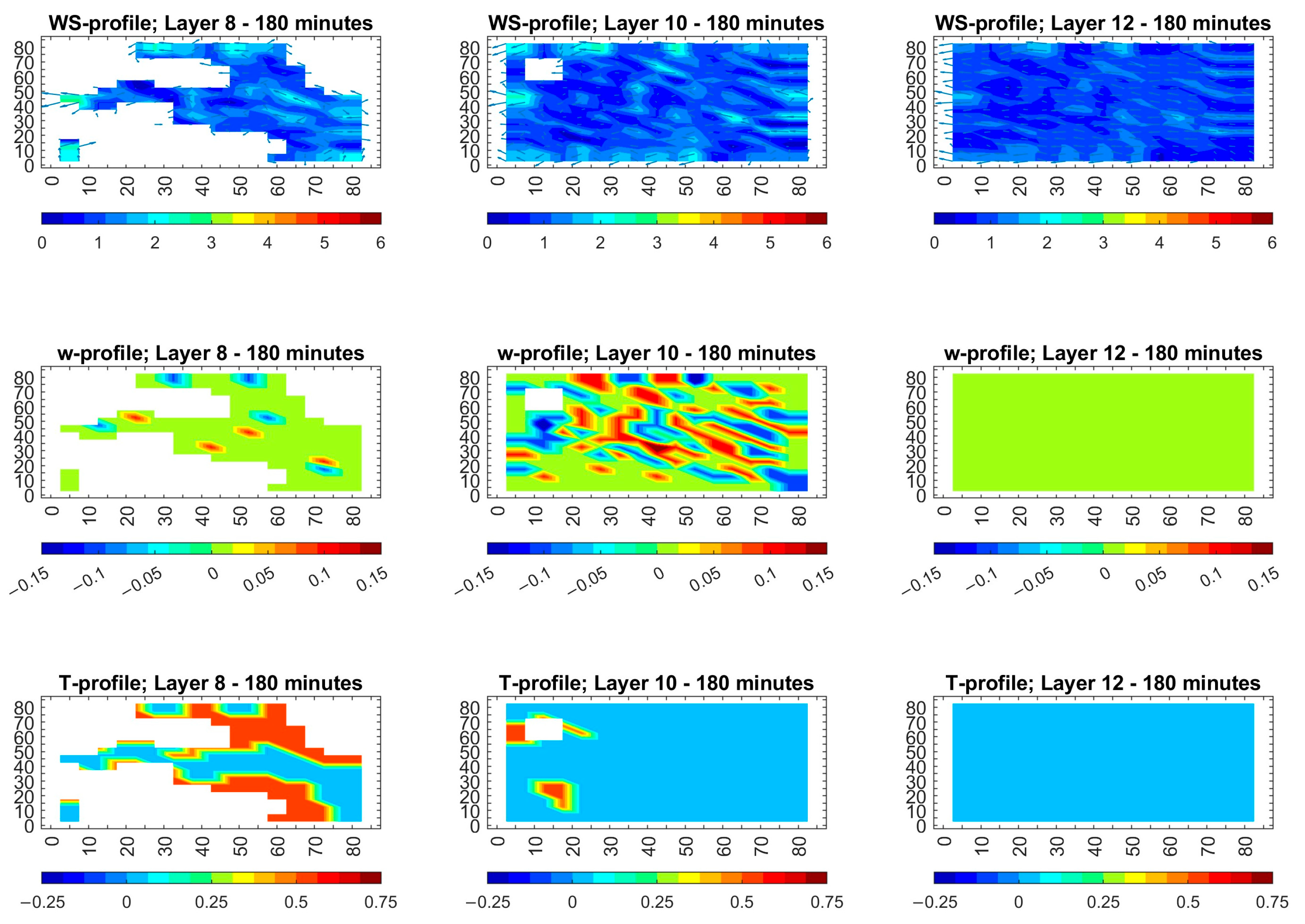
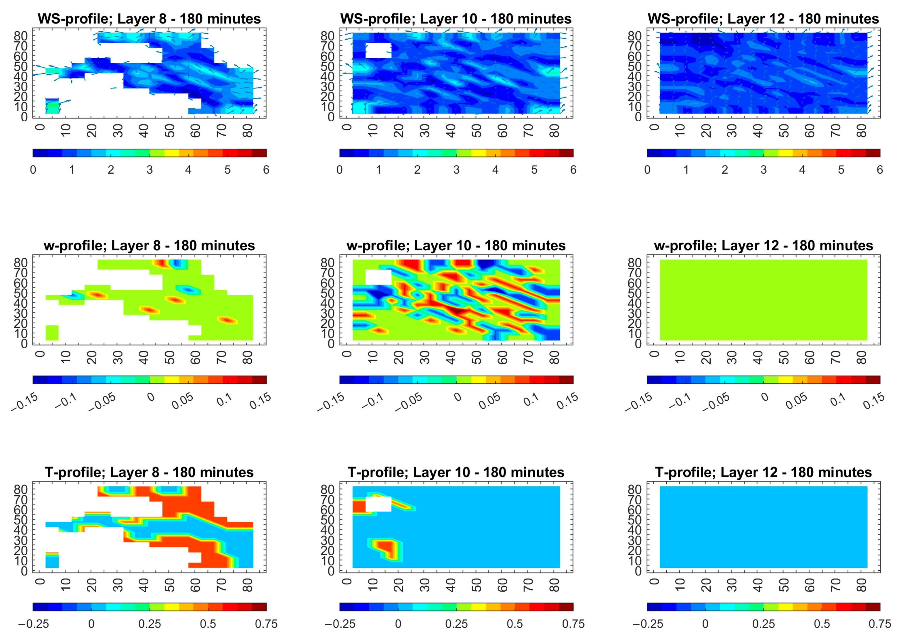
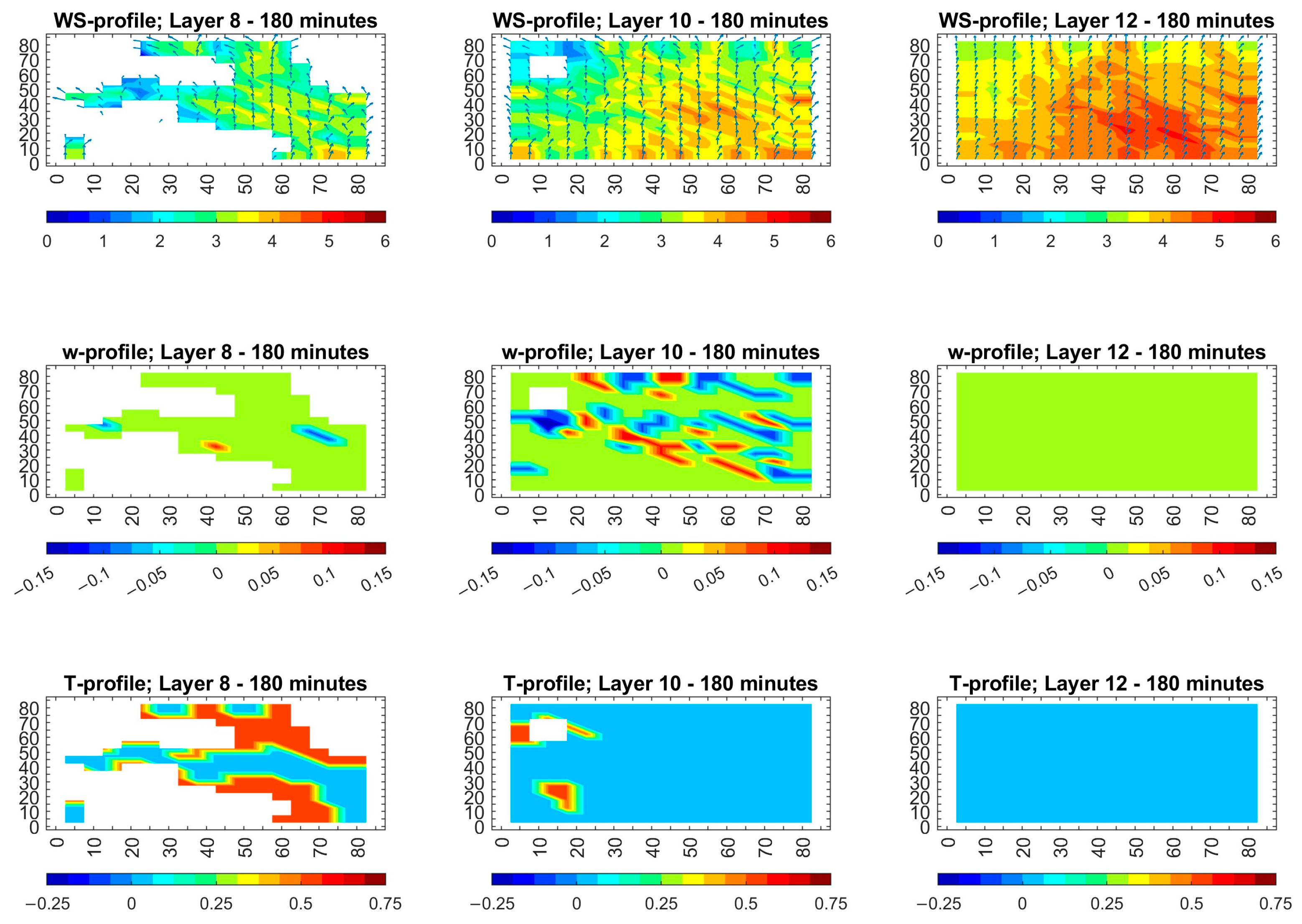
For cold season and 5 m/s wind conditions, for 15° WD, the terrain exerts the strongest influence on L8, where wind is the most irregular. Valleys slow the flow to about 2 m/s, and ridges create localized accelerations. As height increases, the flow smooths out at L10, speeds generally increase up to 3–5 m/s with only minor deviations, and the wind is nearly uniform (L12: 1000–1150 m) at 4–6 m/s regardless of the wind direction. For the 105° WD, the winds follow a similar pattern, with terrain-driven speed reductions in the lowest layer and rapid mixing in higher layers. For the 195° WD, there is also a well-pronounced low-level variability that converges to a steady 5 m/s flow in the upper layers. Overall, directional variability peaks in L8 then subsides in L10 and vanishes by L12, showing that moderate cold-season winds overcome terrain effects within a few hundred meters of the surface (see the first row in Figure 7, Figure 8 and Figure 9).
Moderate wind speeds of 5 m/s during the cold season show distinctive vertical wind motion patterns for the three examined WDs of 15, 105 and 195° (shown in Figure 7, Figure 8 and Figure 9). The vertical motions in L8 remain negligible (almost zero) throughout the entire study area regardless of WDs. For 15° WD, small downdrafts occur in narrow valleys (see Figure 8). For 105° WD, a single downdraft and updraft combination exists. For 195° WD, an additional downdraft is observed that emerges east of the proposed location of NPP. In general, the vertical motions in L8 remain nearly balanced at zero. The vertical monitions in L10 show weak updrafts and downdrafts reaching speeds of 0.1 m/s in both valleys and ridges. Vertical wind speed remains at zero for all heights above 1 km. The simulated surface temperature differences for the cold season and moderate wind speed conditions were examined and are shown in the bottom rows of (Figure 7, Figure 8 and Figure 9). It can be noted that temperature differences in these conditions remain between −0.25 and +0.75 °C, which is similar to the cold season and low-wind (1 m/s) conditions. The contrasts reach their maxima in L8 before decreasing gradually with height for L10 and L12 until these become negligible (practically undetectable) above 1 km. The pattern of temperature differences remains unchanged by stronger wind speeds because surface heating and cooling effects stay near the ground while becoming rapidly neutralized at larger heights.
The summary key findings for the cold season (January) and moderate wind speed (5 m/s) are the following. The strong terrain-driven wind variability was confined to the lowest layer (winds slowed to about 2 m/s in valleys and accelerated on ridges), with rapid mixing to 3–5 m/s above ~700 m and modest vertical mixing peaking at ±0.1 m/s in the mid-layer which then disappeared by ~1 km. There were only small surface–air temperature contrasts near the ground (–0.25 °C to +0.75 °C). As a result, a radioactive plume would be quickly lifted into the middle levels and advected far downwind, reducing its concentration at ground level but spreading contamination across a much larger area.

3.2.2. Moderate Wind Speed (5 m/s) in the Warm Season—July

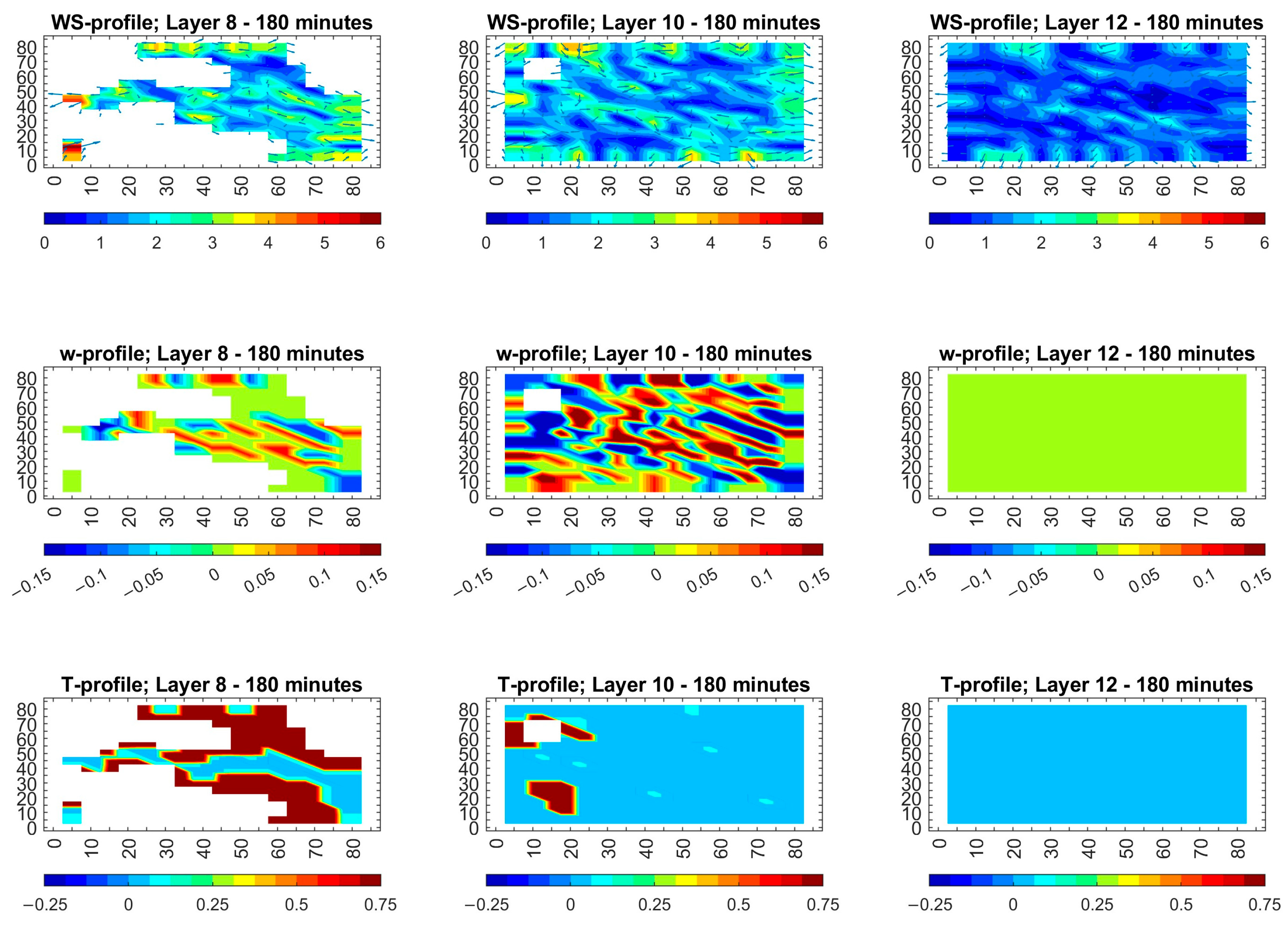
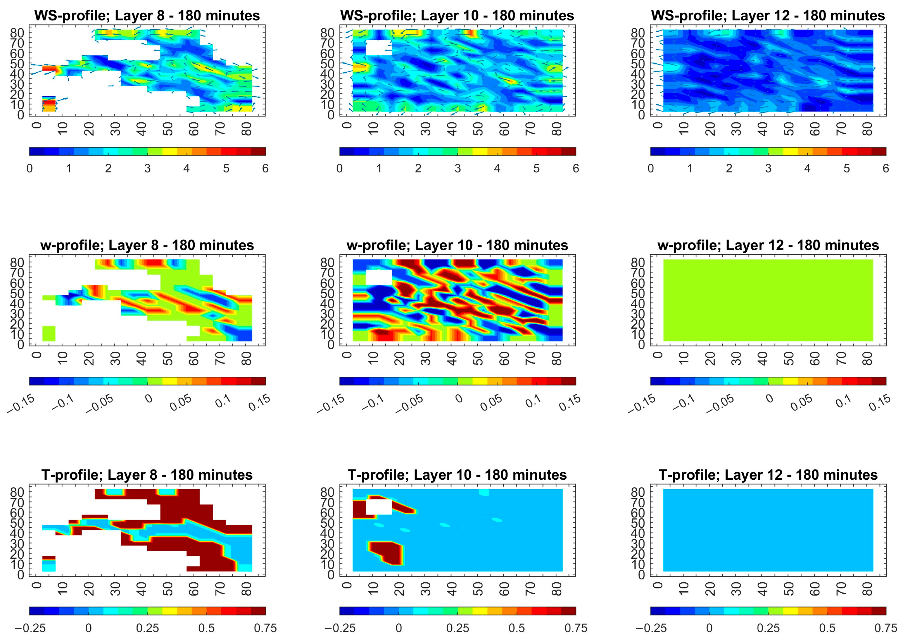
For the warm season and 5 m/s wind conditions, the results are shown in the upper rows of Figure 10, Figure 11 and Figure 12. The lowest atmospheric layer—L8—demonstrates the most significant terrain impact in the warm season, in which the wind speed drops to about 1 m/s in hollows, while it increases to about 6 m/s in ridges. The atmospheric layer L10 shows wind speed variations between 4 and 6 m/s. The atmospheric layer above 1 km shows uniform airflow at 5 m/s speed with minimal terrain impact. It can be noted that the wind direction determines both the pattern and intensity of these variations. For 15° WD, the largest high-speed patches are produced on ridge tops. For 105° WD, the deepest slow zones are created in sheltered valleys. For 195° WD, the strongest channeling effect is produced along slope contours. Although all directions smooth out by the top layer, the low-level contrasts reflect how different wind directions interact with the same hills and valleys.
The middle rows of Figure 10, Figure 11 and Figure 12 show that vertical motion patterns vary with wind direction but become negligible above about 1 km. For the warm season, these updrafts and downdrafts are stronger than in the cold season, and these are small in L8, reaching their maximum intensity of ±0.15 m/s in L10. They then vanish entirely by L12. Thus, changing wind direction simply rotates the layout of weak up/downward vertical motions to match slope orientation, but in all cases, vertical velocities become negligible by about 1 km above ground.
For the warm season and moderate wind conditions, the strongest temperature contrasts occur in the lowest layer because terrain-driven heating and cooling are the most effective near the ground. Sunlit ridges absorb more solar energy, producing warm anomalies up to +2 °C in isolated spots, while shaded hollows lose heat and drop to −0.4 °C. In the higher layers L10 and L12, the direct influence of the surface substantially weakens. Turbulent mixing and horizontal advection homogenize the air, so the temperature differences diminish to ±0.5 °C. Changing wind direction simply shifts where heating and cooling concentrate in the lowest layer. For 15° WD, winds mostly warm northeast-facing slopes; for 105° WD, winds favor east–west ridges; and for 195° WD, winds highlight southwest faces, but this does not alter the rapid decrease in temperature difference with height. This means a similar pattern as in the warm season and with low wind speed.
The key findings for the warm season (July) and moderate wind speed (5 m/s) are the following. The terrain effects are limited to the lowest 500 m, where wind speeds increase from 1 m/s in sheltered areas up to 6 m/s on ridge tops before stabilizing at 4–6 m/s by 700 m. The vertical motions reach ±0.15 m/s in the mid-layer before disappearing above 1 km. The temperature differences decrease from −0.4 °C to +2 °C at the ground to about ±0.5 °C above. As a result, a pollution plume would move swiftly through extensive wind corridors that follow the terrain while receiving moderate vertical mixing, which would stop high contamination at ground level but territorially spread pollution across a broader region.

3.3. Comparison of Scenarios: Cold/Warm Seasons and Low/Moderate Wind Speeds

A summary of scenarios is presented in Table 2 for low (1 m/s) and moderate (5 m/s) wind speeds in the cold and warm seasons (i.e., the months of January and July, respectively) in order to demonstrate how each scenario affects horizontal transport, vertical mixing, air–surface temperature changes and potential for the spread of pollution.
As shown in Table 2, for low speed winds (1 m/s), whether in winter or in summer, airflow remains confined to narrow 1–3 m/s channels among valleys and ridges; vertical mixing is from −0.05 to 0.15 m/s, and temperature contrasts form stable thermal pockets that trap pollution close to the ground, creating high local concentrations with very slow lateral spread. In contrast, for moderate speed winds (5 m/s), the terrain effects vanish within a few hundred meters away from the NPP. Horizontal flow quickly becomes a uniform 3–6 m/s, vertical mixing increases (up to ±0.1 m/s in winter and up ±0.15 m/s in summer), and temperature gradients become negligible, so pollution is swept rapidly downwind, lifted into the middle atmosphere, and dispersed over a much wider area, greatly reducing peak ground-level concentrations (and, subsequently, doses due to radionuclides).

4. Discussion

Our study showed that weak winds during the cold season could lead to the accumulation of pollution in areas close to the surface, particularly in valleys and low-lying areas, increasing local pollution concentrations. In contrast, moderate winds facilitate faster pollution transport to the upper layers of the atmosphere, spreading it over wider distances. Mahura et al. [8], however, focused on pollution transport pathways over long distances using isotropic models over large areas, without considering seasonal or local effects. Despite these differences, both studies agree that wind plays a crucial role in the movement and dispersion of pollution. However, our study provides a more detailed analysis of local meteorological conditions in a specific region, while the study by Mahura et al. [8] focused on large-scale transport without considering local effects.
Regarding the distribution of radioactive materials in the event of nuclear accidents, the study by Nabavi et al. [9] used a reduced FLEXPART model to assess spatial and temporal changes in the distribution of radioactive materials following nuclear accidents. This research emphasizes the use of advanced techniques to track the movement of pollutants in the atmosphere over distance and time, offering a comprehensive understanding of the impact of accidents on the environment. While this study provides a robust model for understanding the dynamics of contaminant dispersion in flat environments, our study focuses on the impact of local meteorological conditions in the heterogeneous terrain surrounding an NPP in Jordan. We use numerical models to simulate the effect of wind and thermal differences on the dispersion of pollution in areas with rugged terrain, which means our study addresses environmental challenges that differ from those discussed by Nabavi et al. [9]. While Nabavi et al. [9] provided a rigorous analysis of flat environments, our study provides in-depth insights into the impact of meteorological conditions on heterogeneous terrain.
While our current study focuses on using numerical models to simulate local meteorological conditions in the area surrounding the proposed NPP in Jordan and analyzing the effects of wind, temperature, and air movement on the dispersion of radioactive contaminants in the event of a future nuclear accident, Ref. [10] focused on measuring air doses in areas surrounding residential zones in Fukushima following the Fukushima Daiichi nuclear accident. Their study relied on actual measurements of the dispersal of radioactive materials in the air, focusing on the effect of wind and weather conditions on the transport of these materials to residential areas and determining the extent of the accident’s impact on the health of the local population.
Based on this approach, proposed future studies should focus on TRANS modeling of atmospheric transport, dispersion, deposition, and radioactive decay of radionuclides, as well as the calculation of doses (due to inhalation, ingestion, etc.) and radiation exposure levels in the event of a hypothetical nuclear accident at the Jordanian NPP. Such a study will provide critically important and useful data for assessments of the impact of nuclear accidents on the environment and public health. These findings will contribute to improving emergency strategies, accurately identifying the geographical areas most at risk, and enhancing the country’s response to a potential nuclear accident.

5. Conclusions

It is well known that nuclear accidents have an impact on the environment and can also lead to fatal consequences to humans. Although nuclear facilities are highly regulated and accidents are rare, it remains important to identify and understand potential hazards.
This study seeks to predict dynamic meteorological conditions to simulate atmospheric transport and offer wind velocity fields and temperature profiles within a 3D terrain domain, where the Jordan NPP (the location of the Samra Energy Power Plant, SEPP) is in the northeastern part of Jordan. The selected scenarios in this study based on cold/warm seasons and low/medium wind speeds underlined that the wind’s direction and speed are influenced by the terrain/relief’s structure. The simulations in the model domain, with an area of 85 × 85 km2, were performed for January and July, taking into account the varying terrain.
These simulations showed that terrain had the largest influence on horizontal wind speeds in the lowest layers near the surface, which resulted in significant variations. The horizontal flow became increasingly uniform with height until it reached a nearly homogeneous state at uppermost layers. Vertical updrafts and downdrafts that affect vertical wind speed (vertical motions) showed a larger intensity in the warm season than in the cold season. These vertical motions were most intense at the L10 layer compared to the L8 layer, and they completely disappeared at altitudes above 1 km. The temperature differences reached their maximum in the lowest layer, decreased steadily with height, and disappeared entirely above 1 km. Overall, these thermal contrasts were more pronounced in the warm season than in the cold season. The simulations showed the difference between ‘trapped’ (1 m/s) and ‘advected’ (5 m/s) wind speed scenarios, but real-world conditions exist between these two scenarios. Consideration of wind speeds between 2 and 4 m/s will be useful in determining the specific points in the modelling domain, where pollution shifts from being trapped to being rapidly carried downwind. Considering future studies, real-time meteorological data from ground-based surface stations and remote sensing data from satellites need to be integrated into an ensemble dispersion framework to minimize uncertainties in simulations.
Emergency planners should establish two protection zones with high-dose-radiation areas near the source and low-dose areas farther away from the source using wind speed thresholds and surface wind trigger-based map alerts. Future research should also combine dose conversion and deposition models to evaluate health risks and make recommendations for land use decisions around the proposed JNPP.

Supplementary Materials

The following supporting information can be downloaded at: https://www.mdpi.com/article/10.3390/atmos16101215/s1, Figure S1. (a) Jordan map showing elevation above sea level and the domain (red square corresponding to 85 × 85 km2), which is also shown from three different prospective: (b) land use, (c) detailed map of elevation above sea level, and (d) converted elevation map as 17 × 17 grid. The location of the hypothetical Jordanian nuclear power plant (JNPP) is marked by a red square in the middle of the domain. Table S1: Geographical properties of the model simulation and their numerical input parameters; Table S2: Model input that describes the meteorological conditions; Table S3: Monthly means of the local meteorological conditions and temperature differences (°C) between land surface and air (TlTa), water surface and air (TwTa), and “hot water” and air (ThwTa). The weather data was obtained from measurements made at the campus of the University of Jordan during 2017. The data for temperature differences was obtained from the “World Climate Guide”.

Author Contributions

Conceptualization, T.H., A.B., A.M., S.A. and M.M.A.-K.; methodology, T.H., A.B., A.M., N.A., S.A. and M.M.A.-K.; software, A.B. and A.M.; validation, S.A., T.H., A.M., N.A., M.M.A.-K., S.M. and S.S.A.-S.; formal analysis, S.A., T.H., A.M., M.M.A.-K. and S.S.A.-S.; investigation, S.A., T.H., A.B., A.M., M.M.A.-K., S.M. and S.S.A.-S.; resources, T.H. and A.M.; data curation, T.H., A.M., S.A., S.M., M.M.A.-K. and S.S.A.-S.; writing—original draft preparation, T.H., A.M. and S.S.A.-S.; writing—review and editing, T.H., A.M., S.S.A.-S., N.A., S.A., S.M., A.B. and M.M.A.-K.; visualization, T.H., A.M., S.A., N.A., M.M.A.-K. and S.S.A.-S.; supervision, T.H. and A.M.; project administration, T.H., A.M. and A.B. All authors have read and agreed to the published version of the manuscript.

Funding

This research received no external funding.

Institutional Review Board Statement

Not applicable.

Informed Consent Statement

Not applicable.

Data Availability Statement

Data will be made available upon request.

Acknowledgments

This work was scientifically supported by the Pan-Eurasian EXperiment (PEEX) Programme, the Finnish Flagship “Atmosphere and Climate Competence Center” (ACCC), and the Research Infrastructure Services Reinforcing Air Quality Monitoring Capacities in European Urban & Industrial AreaS (RI-URBANS; https://riurbans.eu; GA n. 101036245). The INEP’s Model Package (METEO and TRANS) was initially setup, tested, and optimized at the Center for Science Computing (CSC; www.csc.fi) HPC Sisu supercomputer.

Conflicts of Interest

The authors declare no conflicts of interest.

Abbreviations

The following abbreviations are used in this manuscript:
SEPPSamra Energy Power Plant
NPPNuclear Power Plant
JNPPJordanian Nuclear Power Plant
METEOMeso-meteorological Model
WDWind Direction
Layer#Layer 8 (L8), Layer 10 (L10), Layer 12 (L12)

References

  1. Soares da Silva, M.; Pimentel, L.C.G.; Duda, F.P.; Aragão, L.; Silva, C.; Dragaud, I.C.D.A.V.; Vicentini, P.C. Assessment of meteorological settings on air quality modeling system—A proposal for UN-SDG and regulatory studies in non-homogeneous regions in Brazil. Environ. Sci. Pollut. Res. 2023, 30, 1737–1760. [Google Scholar] [CrossRef]
  2. Silva, C.; dos Santos, E.A.; Dussin, I.A.; Montibeller, C.C.; de Avelar Las Casas Rebelo, V.; da Costa Pereira Lavalle Heilbron, M.; Pimentel, L.C.G.; Landau, L. Spatial distribution of strontium and neodymium isotopes in South America: A summary for provenance research. Environ. Earth Sci. 2023, 82, 348. [Google Scholar] [CrossRef]
  3. Silva, C.; Pimentel, L.C.G.; Landau, L.; Filho, P.F.L.H.; Gobbo, F.G.R.; de Jesus de Sousa, P. Supportive elements to the decision-making process in the emergency planning of the Angra dos Reis Nuclear Power Complex, Brazil. Environ. Earth Sci. 2017, 76, 133. [Google Scholar] [CrossRef]
  4. Baklanov, A. Evaluation of Dose, Risk, Vulnerabilities and Consequences for Population and Environment in Euro-Arctic Region. In Arctic Risk–project of the Nordic Arctic Research Programme (NARP); Danish Meteorological Institute Scientific Report 03-18; Danish Meteorological Institute: Copenhagen, Denmark, 2003. [Google Scholar]
  5. Lauritzen, B.; Baklanov, A.; Mahura, A.; Mikkelsen, T.; Sørensen, J.H. Probabilistic risk assessment for long-range atmospheric transport of radionuclides. J. Environ. Radioact. 2007, 96, 110–115. [Google Scholar] [CrossRef]
  6. Mahura, A.G.; Baklanov, A.A.; Sorensen, J.H.; Parker, F.L.; Novikov, V.; Brown, K.; Compton, K.L. Assessment of potential atmospheric transport and deposition patterns Russian Pacific fleet operation. Environ. Monit. Assess. 2005, 101, 261–287. [Google Scholar] [CrossRef]
  7. Baklanov, A.; Mahura, A.; Jaffe, D.; Thaning, L.; Bergman, R.; Andres, R. Atmospheric Transport Patterns and Possible Consequences for the European North after a Nuclear Accident. J. Environ. Radioact. 2002, 60, 23–48. [Google Scholar] [CrossRef]
  8. Mahura, A.G.; Jaffe, D.A.; Andres, R.J.; Merrill, J.T. Atmospheric transport pathways from the Bilibino nuclear power plant to Alaska. Atmos. Environ. 1999, 33, 5115–5122. [Google Scholar] [CrossRef]
  9. Nabavi, S.O.; Christoudias, T.; Proestos, Y.; Fountoukis, C.; Al-Sulaiti, H.; Lelieveld, J. Spatiotemporal variation of radionuclide dispersion from nuclear power plant accidents using FLEXPART mini-ensemble modeling. Atmos. Chem. Phys. 2023, 23, 7719–7739. [Google Scholar] [CrossRef]
  10. Matsuda, N.; Mikami, S.; Sato, T.; Saito, K. Measurements of air dose rates in and around houses in the Fukushima Prefecture in Japan after the Fukushima accident. J. Environ. Radioact. 2017, 166, 427–435. [Google Scholar] [CrossRef]
  11. Brandt, J.; Mikkelsen, T.; Thykier-Nielsen, S.; Zlatev, Z. Using a Combination of Two Models in Tracer Simulations. Mathl. Comput. Model. 1996, 23, 99–115. [Google Scholar] [CrossRef]
  12. Andren, A. Evaluation of a Turbulence Closure Scheme for Air-Pollution Applications. J. Appl. Meteorol. 1990, 29, 224–239. [Google Scholar] [CrossRef]
  13. Starchenko, A.V.; Shelmina, E.A.; Kizhnera, L.I.; Odintsov, S.L.; Prokhanova, S.A.; Danilkin, E.A.; Strebkov, E.A. Application of mesoscale models for numerical investigation of urban air quality at calm wind conditions. In Proceedings of the 27th International Symposium on Atmospheric and Ocean Optics, Atmospheric Physics, Moscow, Russia, 5–9 July 2021; Matvienko, G.G., Romanovskii, O.A., Eds.; SPIE: Bellingham, WA, USA, 2021; Volume 11916. [Google Scholar] [CrossRef]
  14. Starchenko, A.; Elena Shelmina, E.; Kizhner, L. Numerical Simulation of Meteorological Conditions and Air Quality above Tomsk, West Siberia. Atmosphere 2020, 11, 1148. [Google Scholar] [CrossRef]
  15. Christoudias, T.; Proestos, Y.; Lelieveld, J. Atmospheric Dispersion of Radioactivity from Nuclear Power Plant Accidents: Global Assessment and Case Study for the Eastern Mediterranean and Middle East. Energies 2014, 7, 8338–8354. [Google Scholar] [CrossRef]
  16. Forecast of the near ground air temperature based on the multilayer perceptron model. J. Phys. Conf. Ser. 1989, 012025. [CrossRef]
  17. Mészáros, R.; Leelőssy, A.; Vincze, C.; Szűcs, M.; Kovács, T.; Lagzi, I. Estimation of the dispersion of an accidental release of radionuclides and toxic materials based on weather type classification. Theor. Appl. Climatol. 2012, 107, 375–387. [Google Scholar] [CrossRef]
  18. Shamsuddin, S.D.; Basri, N.A.; Omar, N.; Koh, M.-H.; Ramli, A.T.; Wan Hassan, W.M.S. Radioactive dispersion analysis for hypothetical nuclear power plant (NPP) candidate site in Perak state, Malaysia. EPJ Web Conf. 2017, 156, 00009. [Google Scholar] [CrossRef]
  19. Tang, B.; Wang, H.; Xu, J.; Lin, J.; Hu, J.; Chen, R. High-Resolution Simulation of the Near-Field Pollutant Dispersion in a Nuclear Power Plant Community with High-Performance Computing. J. Nonlinear Math. Phys. 2024, 31, 6. [Google Scholar] [CrossRef]
  20. Lagzi, I.; Karman, D.; Turanyi, T.; Tomlin, A.S.; Haszpra, L. Simulation of the dispersion of nuclear contamination using an adaptive Eulerian grid model. J. Environ. Radioact. 2024, 75, 59–82. [Google Scholar] [CrossRef] [PubMed]
  21. INES, International Nuclear and Radiological Event Scale. Available online: https://www.iaea.org/topics/emergency-preparedness-and-response-epr/international-nuclear-radiological-event-scale-ines (accessed on 5 October 2025).
  22. Baklanov, A.A.; Mahura, A.G.; Morozov, S.V. The Simulation of Radioactive Pollution of the Environment after a Hypothetical Accident at the Kola Nuclear Power Plant. J. Environ. Radioact. 1994, 25, 65–84. [Google Scholar] [CrossRef]
  23. Struzewska, J.; Kaminski, J.W. Impact of urban parameterization on high resolution air quality forecast with the GEM—AQ model. Atmos. Chem. Phys. 2012, 12, 10387–10404. [Google Scholar] [CrossRef]
  24. Otosaka, S.; Kobayashi, T. Sedimentation and remobilization of radiocesium in the coastal area of Ibaraki, 70 km south of the Fukushima Dai-ichi Nuclear Power Plant. Environ. Monit. Assess. 2013, 185, 5419–5433. [Google Scholar] [CrossRef] [PubMed]
  25. Al-Kloub, M.M.; Mahura, A.; Baklanov, A.; Atashi, N.; Hussein, T. Model Simulations of Local Meteorological Conditions in the Vicinity of a Hypothetical Nuclear Power Plant in Jordan. Jordan J. Earth Environ. Sci. 2020, 11, 26–37. [Google Scholar]
  26. World Climate Guide, Climates for Travel. Available online: https://www.climatestotravel.com/climate/jordan (accessed on 5 October 2025).
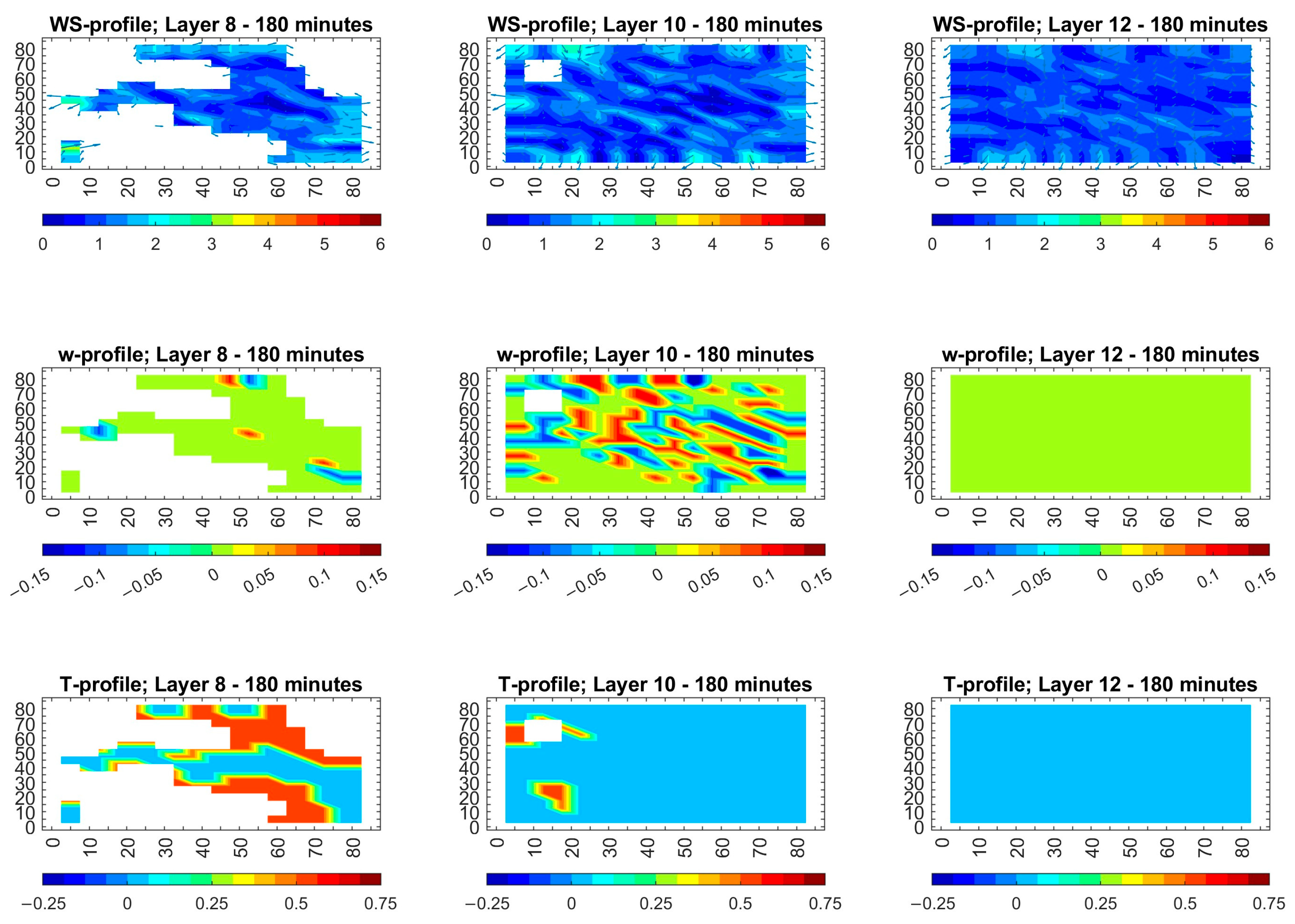
Figure 1. Results of METEO simulations after 180 min for unfavorable prevailing wind directions at 15° and 1 m/s in the cold season (January): (upper row) wind fields (m/s) over the terrain in layers L8 (425–550 m asl), L10 (700–850 m asl), and L12 (1000–1150 m); (middle row) vertical motions (m/s), and (lower row) temperature differences.
Atmosphere 16 01215 g001
Figure 2. Results of METEO simulations after 180 min for unfavorable prevailing wind direction at 105° and 1 m/s during cold season (January): (upper row) wind fields (m/s) over the terrain in layers L8 (425–550 m asl), L10 (700–850 m asl), and L12 (1000–1150 m); (middle row) vertical motions (m/s), and (lower row) temperature differences.
Atmosphere 16 01215 g002
Figure 3. Results of METEO simulations after 180 min for unfavorable prevailing wind directions at 195° and 1 m/s in the cold season (January): (upper row) wind fields (m/s) over the terrain in layers L8 (425–550 m asl), L10 (700–850 m asl), and L12 (1000–1150 m); (middle row) vertical motions (m/s), and (lower row) temperature differences.
Atmosphere 16 01215 g003
Figure 4. Results of METEO simulations after 180 min for unfavorable prevailing wind direction at 15° and 1 m/s in the warm season (July): (upper row) wind fields (m/s) over the terrain in layers L8 (425–550 m asl), L10 (700–850 m asl), and L12 (1000–1150 m), (middle row) vertical motions (m/s), and (lower row) temperature differences.
Atmosphere 16 01215 g004
Figure 5. Results of METEO simulations after 180 min for unfavorable prevailing wind direction at 105° and 1 m/s in the warm season (July): (upper row) wind fields (m/s) over the terrain in layers L8 (425–550 m asl), L10 (700–850 m asl), and L12 (1000–1150 m), (middle row) vertical motions (m/s), and (lower row) temperature differences.
Atmosphere 16 01215 g005
Figure 6. Results of METEO simulations after 180 min for unfavorable prevailing wind direction at 195° and 1 m/s in the warm season (July): (upper row) wind fields (m/s) over the terrain in layers L8 (425–550 m asl), L10 (700–850 m asl), and L12 (1000–1150 m); (middle row) vertical motions (m/s), and (lower row) temperature differences.
Atmosphere 16 01215 g006
Figure 7. Results of METEO simulations after 180 min for unfavorable prevailing wind directions at 15° and 5 m/s in the cold season (January): (upper row) wind fields (m/s) over the terrain in layers L8 (425–550 m asl), L10 (700–850 m asl), and L12 (1000–1150 m); (middle row) vertical motions (m/s), and (lower row) temperature differences.
Atmosphere 16 01215 g007
Figure 8. Results of METEO simulations after 180 min for unfavorable prevailing wind direction at 105° and 5 m/s during cold season (January): (upper row) wind fields (m/s) over the terrain in layers L8 (425–550 m asl), L10 (700–850 m asl), and L12 (1000–1150 m), (middle row) vertical motions (m/s), and (lower row) temperature differences.
Atmosphere 16 01215 g008
Figure 9. Results of METEO simulations after 180 min for unfavorable prevailing wind direction at 195° and 5 m/s in the cold season (January): (upper row) wind fields (m/s) over the terrain in layers L8 (425–550 m asl), L10 (700–850 m asl), and L12 (1000–1150 m), (middle row) vertical motions (m/s), and (lower row) temperature differences.
Atmosphere 16 01215 g009
Figure 10. Results of METEO simulations after 180 min for unfavorable prevailing wind directions at 15° and 5 m/s in the warm season (July): (upper row) wind fields (m/s) over the terrain in layers L8 (425–550 m asl), L10 (700–850 m asl), and L12 (1000–1150 m); (middle row) vertical motions (m/s); and (lower row) temperature differences.
Atmosphere 16 01215 g010
Figure 11. Results of METEO simulations after 180 min for unfavorable prevailing wind directions at 105°and 5 m/s in the warm season (July): (upper row) wind fields (m/s) over the terrain in layers L8 (425–550 m asl), L10 (700–850 m asl), and L12 (1000–1150 m); (middle row) vertical motions (m/s); and (lower row) temperature differences.
Atmosphere 16 01215 g011
Figure 12. Results of METEO simulations after 180 min for unfavorable prevailing wind directions at 195°and 5 m/s in the warm season (July): (upper row) wind fields (m/s) over the terrain in layers L8 (425–550 m asl), L10 (700–850 m asl), and L12 (1000–1150 m); (middle row) vertical motions (m/s); and (lower row) temperature differences.
Atmosphere 16 01215 g012
Table 1. Unfavorable local meteorological conditions.
MonthTemperature
(°C)
Relative
Humidity
(%)
Hourly
Rainfall
(mm/h)
Daily
Rainfall
(mm)
TlTaTwTaThwTaWind
Direction
(Degree)
Wind
Speed
(m/s)
January7.0780.143.3613615, 105, 1951 and 5
July26.5380.000.003−2115, 105, 1951 and 5
Table 2. Results of horizontal transport, vertical mixing, surface temperature changes, and the potential spread of pollutants under low-wind (1 m/s) and moderate-wind (5 m/s) conditions in both cold and warm seasons.
Aspect1 m/s (Cold: Jan)1 m/s (Warm: Jul)5 m/s (Cold: Jan)5 m/s (Warm: Jul)
Horizontal flowNarrow 1–3 m/s channels in valleys, slow spreadNarrow 1–2 m/s channels; slight ridge–valley flowUniform 3–5 m/s above 700 m; rapid advection1–6 m/s near surface, then 4–6 m/s broad flow
Vertical mixingVery weak (±0.05 m/s) up to ~700 mWeak-to-moderate (±0.15 m/s) peaking at 700–850 mModest (±0.1 m/s) to ~700 m, then zeroModerate (±0.15 m/s) to ~700 m, then zero
Thermal contrasts ΔT−0.25 to +0.75 °C, peaks in lowest layer–0.5 to +2.0 °C, peaks in lowest layer−0.25 to +0.75 °C, confined near ground−0.4 to +2.0 °C, confined near ground
Pollutant dispersionTrapped in valleys; high local concentrationsTrapped in thermal pools; slow lateral spreadThe plume moves quickly with the wind, rises into the mid-atmosphere, and spreads out over a wide areaThe plume moves quickly with the wind, rises into the mid-atmosphere, and spreads out over a wide area
Disclaimer/Publisher’s Note: The statements, opinions and data contained in all publications are solely those of the individual author(s) and contributor(s) and not of MDPI and/or the editor(s). MDPI and/or the editor(s) disclaim responsibility for any injury to people or property resulting from any ideas, methods, instructions or products referred to in the content.