Article

Analysis of Dual-Polarimetric Radar Observations of Precipitation Phase during Snowstorm Events in Jiangsu Province, China

1
Jiangsu Meteorological Observatory, Nanjing 210041, China
2
China Meteorological Administration Hydro-Meteorology Key Laboratory, Beijing 100081, China
*
Author to whom correspondence should be addressed.
Atmosphere 2024, 15(3), 321; https://doi.org/10.3390/atmos15030321
Submission received: 18 January 2024 / Revised: 26 February 2024 / Accepted: 29 February 2024 / Published: 4 March 2024
(This article belongs to the Special Issue Data Assimilation for Predicting Hurricane, Typhoon and Storm)

Abstract

:
Based on ground observed data, S-band dual-polarization radar data, and ERA-5 reanalysis data, the statistical characteristics of polarimetric parameters and the application of melting layer (ML) and hydrometeor classification (HCL) products during eight snowstorm events in Jiangsu Province from 2020 to 2022 were investigated. A heavy snowstorm that went through different phases of rain, sleet, and pure snow and that occurred on 29 December 2020 was also analyzed as a typical example. The results showed the following: During the phase transition between rain and snow in the Jiangsu region, the basic reflectivity factor ZH ≥ 27 dBZ, the zero-order lag correlation coefficient CC ≤ 0.93, and the differential reflectivity ZDR ≥ 1.0 dB were important indicators for judging the melting layer while the specific differential phase KDP changed slightly. The snowstorm event was well observed and recorded by the Yancheng dual-polarimetric radar, whose low value area of CC coincided mostly with the melting layer. The ML products and HCL products based on fuzzy-logic hydrometeor classification algorithms can help identify the melting layer and the properties of precipitation particles. ML products are more reliable when the melting layer is high and can better show the trends of melting layer decline. They can certainly serve as a reference for detecting and judging precipitation phase changes in winter in Jiangsu Province.

1. Introduction

Snowstorms are a common and disastrous weather phenomenon in winter in Jiangsu Province and the East China region. Heavy snowstorms are often accompanied by other meteorological disasters such as low temperature damage and freezing disasters, causing significant losses to industrial and agricultural production, transportation, and the safety of people’s lives and property. Jiangsu Province is in the middle and lower reaches of the Yangtze River. In winter, it is influenced by cold and warm air masses, resulting in frequent and complex transitions in the precipitation phase. Therefore, the accurate forecasting of snowfall and the timing of precipitation phase changes are of great practical significance in formulating effective defense measures and avoiding or mitigating their harm.
In recent years, meteorologists have made significant research progress in the field of snowfall forecasting, including in climate or stratification characteristics [1,2,3,4], and in forecasting focus [5,6,7]. Their studies have given us more confidence in predicting winter precipitation. However, different phases of winter precipitation have significantly different societal impacts, making short-term forecasting and warning services important. Determining the phase of precipitation has always been a challenge for forecasters on the account of limited monitoring methods. The single polarization radar and raindrop spectrometer have some monitoring capabilities for snowfall, but winter precipitation echoes are often weak and are frequently affected by the melting layer [8,9]. Laser raindrop spectrometer, on the other hand, has limited observation stations and can only observe surface hydrometeor particle properties [10], thus having weaker monitoring and early warning capabilities for the rain–snow transition process.
In the use of dual-polarization radar data, studies have shown that using a dual-polarization radar can determine the properties of precipitation particles in a real-time manner [11,12,13,14,15]. It retains the high spatial and temporal resolution advantages of single-polarimetric weather radars and can obtain new polarization parameters such as the differential reflectivity (ZDR), specific differential phase (KDP), and zero-order lag correlation coefficient (CC) as independent variables. It can better monitor the microphysical characteristics of particles [16,17,18,19]; reflect the characteristics of precipitation particles such as size, density, shape, and spatial orientation [20]; and provide more comprehensive information to identify the phase and spectral distribution of hydrometeors, deepening the understanding of microphysical evolution in precipitation processes [21,22,23,24].
As early as in the 1980s, some studies began to use the real-time dual-polarimetric radar reflectivity factors for snowfall nowcasting in winter [25,26]. Furthermore, by developing different wavelengths of dual-polarimetric radars and microphysical principles of snowfall, fuzzy-logic hydrometeor classification algorithms were used to distinguish snow and types of ice crystals [13]. Some studies undertook detailed analyses of the structure and maintenance mechanisms of winter snowfall cloud bands based on Doppler radars, revealing that meso-scale vorticities on convective cloud bands can sustain cloud clusters, causing snowstorms [27,28,29]. Significant ice crystal growth can lead to snowstorms in convective clouds below a height of 4 km [30,31]. Also, studies used dual-polarimetric Doppler radar RHI data and microphysical model simulations of various parameters’ vertical profiles to analyze the structures of and variations in polarization parameters vertically during winter storms [32]. In recent years, FY satellite [33,34,35,36] and radar data assimilation [37,38,39,40,41,42,43] have been applied in the monitoring and prediction of meso-scale weather systems.
Domestic research has already used dual-polarization Doppler radar data and sounding data to analyze snowstorm events [44]. A snowfall phase identification method based on the bright band recognition at the zero-degree layer has been proposed [45]. The temporal and spatial evolution characteristics of radar parameters and the zero-degree bright band have been analyzed, highlighting the advantages of dual-polarization radar in winter snowfall forecasting [46,47,48]. Some studies have also indicated that indicators such as the ZDR (0~0.5 dB), a small KDP (0.1° km−1), and a large CC (0.99) can be used as discrimination thresholds for snowfall processes with low temperatures in the upper air and high near-surface layers [49,50]. It has also been found that the increase in ground snowfall is associated with an increase in KDP in the upper atmosphere [51,52]. Meanwhile, the melting layer product (ML) and hydrometeor classification (HCL) product of dual-polarization radar have certain reference values for the detection of winter precipitation particles and the determination of the precipitation phase [53].
Seven S-band Doppler radars have achieved dual-polarization upgrades in 2022 in Jiangsu Province. Yet the application research on dual-polarization radars has mainly focused on heavy precipitation and hail, with less emphasis on snowfall. Due to differences in precipitation storm structure, regional differences, instrument errors, and other factors, the applicability of previous research needs to be verified in Jiangsu Province. Dual-polarization radar observations have a wide coverage range, high spatio-temporal resolution, and timely acquisition and can determine the precipitation particle phase and melting layer height at night. Since the cancellation of nighttime manual observations, it has been crucial to use dual-polarization radars to determine the precipitation phase, which has played an important role in short-term monitoring, forecasting, and warning for snowfall.
To this end, this paper conducts a statistical analysis of the dual-polarization parameters of eight snowfall events from 2020 to 2022 in Jiangsu Province. Then, the applications of ML products and HCL products are verified. Finally, focusing on the heavy snowstorm event on 29 December 2020, a detailed analysis is conducted on the PPI and RHI charts of dual-polarization radar parameters, as well as on the evaluation of radar products and precipitation phase identification. We hope that this study can give important indicators for judging the melting layer based on dual-polarimetric radar parameters and improve forecasters’ ability to predict rain–snow phase transitions and issue warnings for approaching snowfall.

2. Study Area, Data, and Methods

2.1. Study Area and Radar Information

Jiangsu Province is located in the Yangtze River basin in eastern China. Its geographical location is between 116°21′ and 121°56′ E and between 30°45′ and 35°08′ N. The coastline of Jiangsu Province reaches 954 km. With the Yellow Sea to the east, Jiangsu Province is significantly impacted by the ocean. Affected by East Asian monsoons and sea–land thermal contrast, this region has a mild climate and four distinct seasons. There are 13 cities in Jiangsu Province. As of December 2022, out of the 9 existing S-band Doppler radars in Jiangsu, 7 radars had completed the dual-polarization upgrade. These radars are located in Nanjing, Changzhou, Nantong, Yancheng, Xuzhou, Lianyungang, and Taizhou (Figure 1). The range resolution of radar is 250 m, and the maximum detection range is 460 km (230 km in this paper). Each radar adopts an improved VCP21 volumetric scanning strategy, with elevation angles of 0.0°, 0.5°, 1.5°, 2.4 °, 3.5°, 4.5°, 6.0°, 7.5°, and 9.0°. This mode can obtain observations closer to the ground. The volumetric scanning data from the dual-polarization radar are used to identify the real-time rain and snow, which are recorded every 6 min.

2.2. Data and Processing

Snowfall processes in Jiangsu Province from 2020 to 2022 were investigated in this study. Among them, on 29 December 2020, snowfall occurred across the province from north to south. Therefore, to increase study samples, 4 individual cases were further divided by the time and geographical location of the snowfall. In total, there were 8 snowfall cases that can be studied. The detailed information for each snowfall case can be found in Table 1.
The data in the study included hourly meteorological observations obtained from surface meteorological observation stations from 2020 to 2022. The meteorological elements included precipitation, temperature (°C), pressure (hPa), surface relative humidity (%), wind speed (m·s−1), wind direction, and snow depth (cm). The height of the zero-degree layer during statistical real-time observations was determined using sounding data from the Nanjing, Sheyang, and Yancheng sounding stations at 12 h intervals. For some snowfall events that did not occur around 08 LST and 20 LST, real-time sounding data could not be used to determine the height of the zero-degree layer. For these snowfall events, the latest hourly fifth generation of the reanalysis data (ERA5) with a resolution of 0.25° was also utilized to examine the height of the zero-degree layer from the European Centre for Medium-Range Weather Forecasts (ECMWF) [54].

2.3. Methods

2.3.1. Basic Parameters of Dual-Polarimetric Radar

Compared with single Doppler radar, dual-polarization radar has three additional products, namely zero-lag correlation coefficient (ρhv(0), hereinafter referred to as CC), differential reflectivity (ZDR), and specific differential phase (KDP). They were proposed to improve the precipitation estimation performance of radar [55,56,57,58,59]. According to their corresponding algorithms, they have specific uses and have been defined as follows:
ρ h v ( 0 ) = R h v ( 0 ) R h h ( 0 ) R v v ( 0 )
Here, R h v (0) represents the cross-correlation coefficient between the horizontal and vertical channels. R h h (0) and R v v (0) represent the zero-order auto-correlation coefficients of the horizontal and vertical channels, describing the consistency of the horizontal and vertical pulse variations that radar receives. When the hydrometeors in the atmosphere are small raindrops, dry snow, or particles with small differences in horizontal and vertical sizes, the CC value is larger, mostly above 0.95. Conversely, with large raindrops, large hails, or particles with significant differences in horizontal and vertical sizes, the CC value is smaller.
By considering the different horizontal and vertical sizes of particles, with the help of other observational data, it is possible to determine the particle properties and infer the melting layer height.
Z DR = Z h Z v
Here, ZDR represents the differential reflectivity (unit: dB), which is the difference between the reflectivity in the horizontal channel (Zh) and the vertical channel (ZV). It reveals the average shape of the hydrometeors. When there is a large difference in shape of the hydrometeors in the atmosphere, such as large raindrops, large hails, or solid–liquid mixtures, the difference between the horizontal and vertical sizes is large, leading to a large absolute value of ZDR. Also, due to gravity, the horizontal size of precipitation particles in the atmosphere is larger than the vertical size, leading to mostly positive values of ZDR. When there is a significant difference between the horizontal and vertical sizes, ZDR significantly increases.
K D P = φ D P ( r 2 ) φ D P ( r 1 ) 2 ( r 2 r 1 )
Here, KDP represents specific differential phase, which is the reciprocal of the difference in phase shift between the horizontal and vertical channels. φDP(r1) and φDP(r2) represent the differential phase shifts caused by the phase difference between the horizontal and vertical channels at distances r1 and r2 from the radar, respectively. KDP mainly calculates the difference in phase shift at different distances in the radar’s coverage area. In general, liquid precipitation particles can cause a large KDP value, and more raindrops, with larger and flatter shapes, lead to larger KDP value. This value performs well in determining heavy raindrops. However, under weak precipitation or winter snow, the KDP value is generally small.
To better utilize dual-polarimetric radar observation data, we have taken the following steps to calibrate the radar and preprocess radar base data. In terms of calibration of radar ZDR system bias, Drizzle method [60] is used to correct the ZDR system bias by using light rain echoes with echo intensity between 15 and 25 dBZ. The theoretical value of ZDR for light rain echoes is around 0 dB, and by calculating the difference between the observed and the theoretical value, the ZDR system bias can be obtained. As for the reflectivity factor (ZH) and ZDR, median filters are applied and a sliding average of 5 range bins along the radial direction is used. This helps with elimination of outliers and reduces the influence of random fluctuations. In order to accurately estimate KDP, the initial phase is calibrated based on the average differential phase of ground clutter. Then, KDP is calculated through smooth filtering and linear programming while ensuring the values are non-negative [61]. Non-meteorological echoes such as turbulence scattering and abnormal clutter are also excluded.

2.3.2. Secondary Products of Dual-Polarimetric Radar

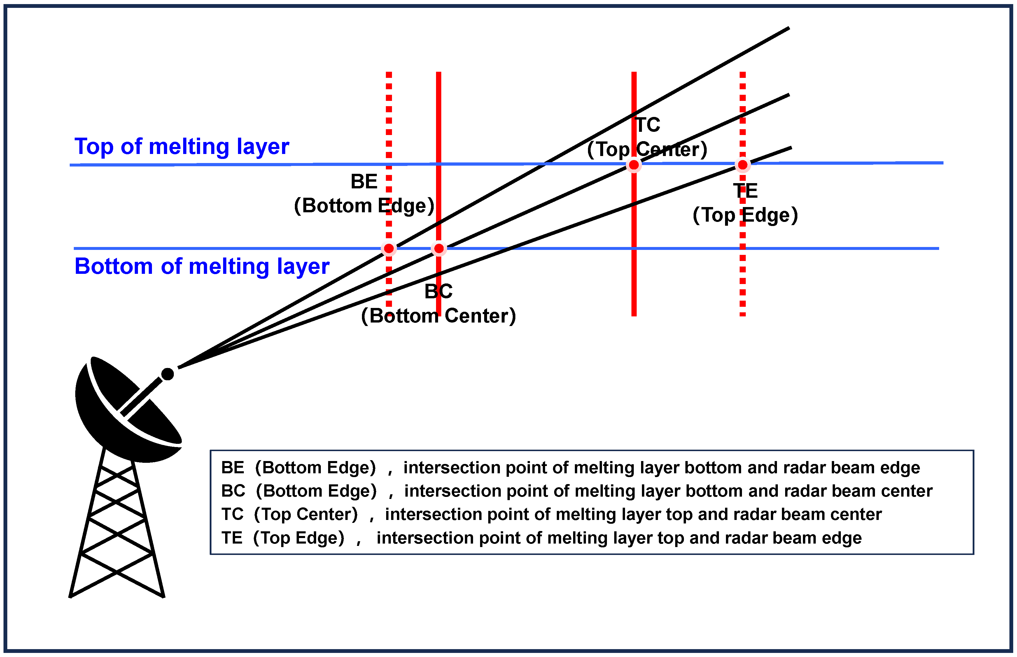
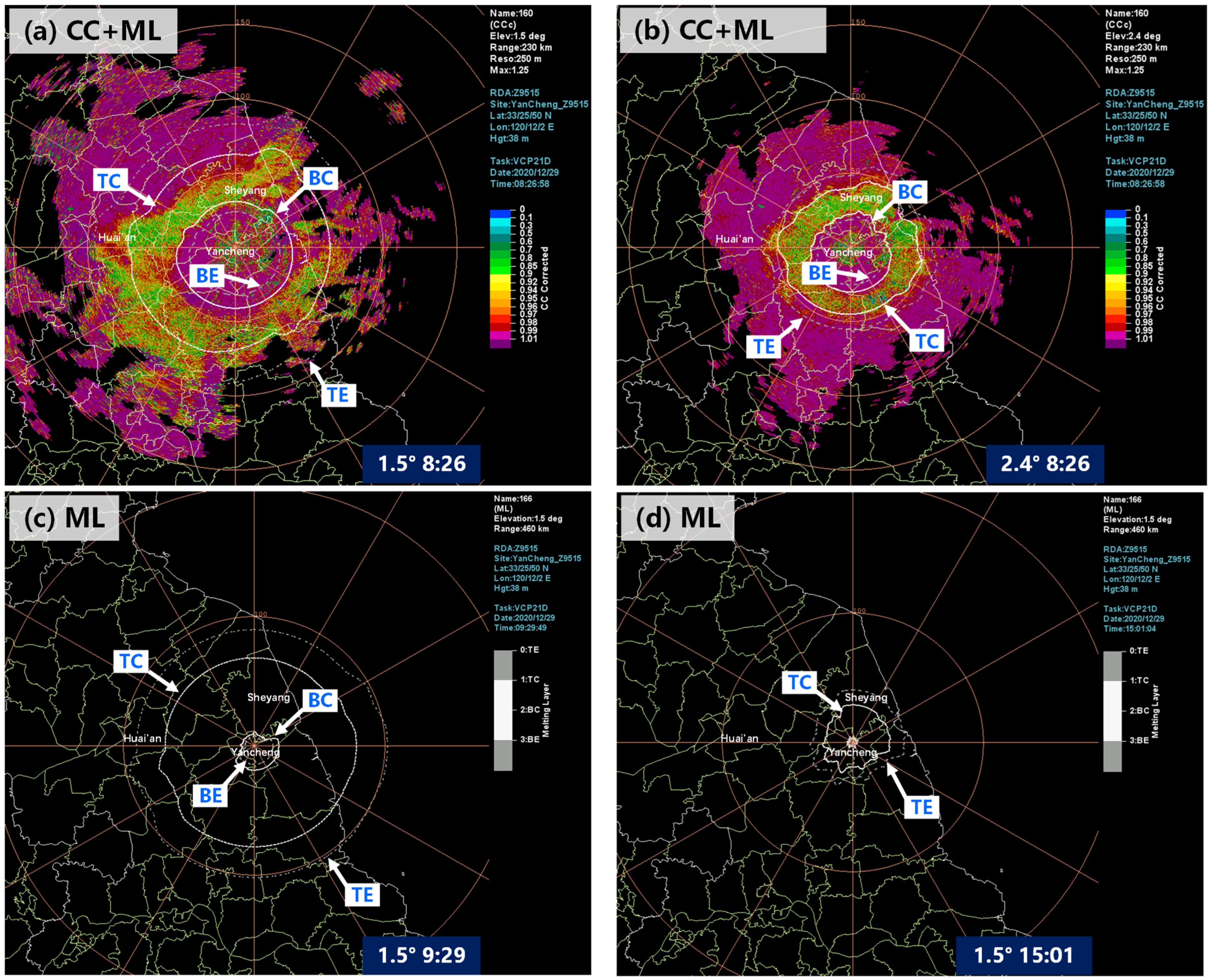
The dual-polarization radar provides the melting layer (ML) product through objective algorithms. Figure 2 illustrates the sketch map of melting layer (ML) products, where BE represents the intersection point between the upper boundary of the radar beam and the lower boundary of the melting layer, shown as the innermost dashed line in the ML diagram; BC represents the intersection point between the beam center and the lower boundary of the melting layer, shown as the inner solid line; TC represents the intersection point between the beam center and the upper boundary of the melting layer, shown as the outer solid line; and TE represents the intersection point between the lower boundary of the beam and the upper boundary of the melting layer, shown as the outer dashed line. Due to the widening of the radar beam, there might be some errors in the ML product when far from the radar.
The dual-polarization radar provides objective hydrometeor classification (HCL) products, which use fuzzy-logic hydrometeor classification algorithms (Table 2) [62,63] to determine the properties of precipitation particles through fuzzy processing of different dual-polarimetric parameters. The precipitation particles in the atmosphere are objectively classified into rain, big drops, hail, ice crystals, and dry and wet snow. In Section 3.2.3 of this study, the application effectiveness values of the secondary products (ML and HCL) from the radar are tested. The objective judgment results of the dual-polarization radar on the properties of precipitation particles are compared with subjective judgments and observations.

3. Results

3.1. Statistical Characteristics of Dual-Polarimetric Radar Data

3.1.1. Statistical Analysis of Parameters

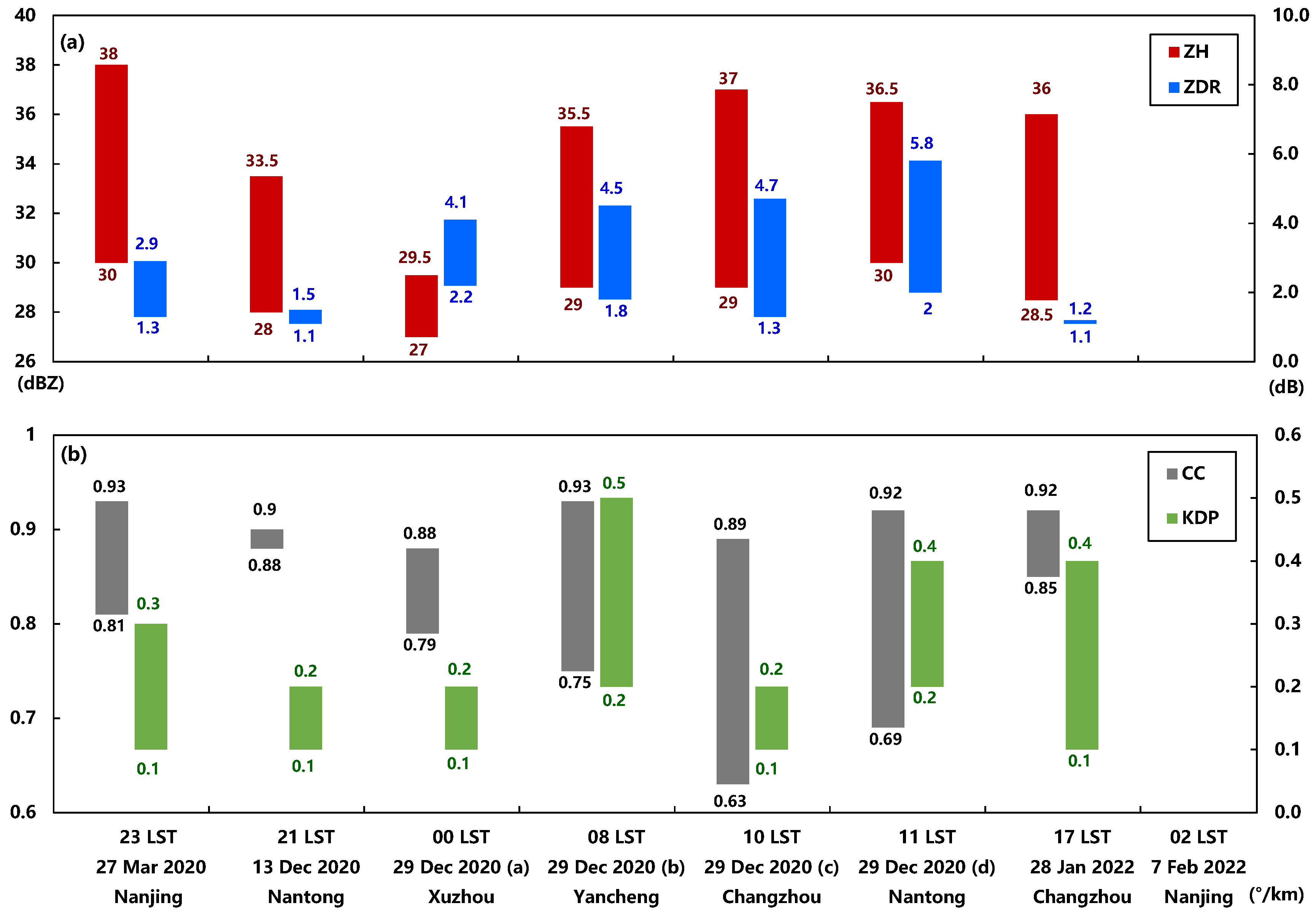
Here, we focus on the rain and snow transition periods of each individual snowfall process from 2020 to 2022. We can generally determine the position and height of the melting layer from the PPI and RHI charts of a closest dual-polarimetric S-band radar. Figure 3 shows the variation ranges of the parameters of the melting layer such as the basic reflectivity (ZH), zero-lag correlation coefficient (CC), differential reflectivity (ZDR), and specific differential phase (KDP). Values at the tops/bottoms of the bars represent the minimum/maximum values of the corresponding parameters. A longer color bar indicates a much wider variation amplitude.
Among them, on 7 February 2022, the ground temperature had already reached 0 °C at the beginning of the process due to a rapid decrease. Therefore, the precipitation phase at the beginning was solid precipitation, and the melting layer was close to the ground, below 1 km. The radar detection height of 1 km is mainly within a 30 km range from the radar center. Within this range, the clutter of ground objects is relatively high, which has a certain impact on the observation of polarimetric parameters such as CC, ZDR, and KDP. Therefore, it was difficult to read the polarimetric parameter data correctly.
From the statistical analysis of CC values, for most processes within a range of 30–80 km from the radar, the CC values were generally scattered and relatively small, mostly below 0.95, even with CC values being below 0.7 somewhere. The small CC values indicate that the particle properties and shapes within this region are diverse, leading to a large discrepancy between the horizontal and vertical pulses received by the radar. Generally, small CC values indicate the detection of hail, large raindrops or particles in a mixed-phase state. In winter, poor moisture conditions and weak upward motion obviously cannot form large water droplets or hailstones. Therefore, the mixed particles in different phases constitute the direct cause of the low CC values in this region.
From the statistical analysis of ZDR, it can be observed that ZDR values generally exceeded 1 dB, with some processes reaching maximum values exceeding 5 dB. In summer heavy rainfall processes, with abundant moisture and strong upward motion, larger liquid droplets are often present in the atmosphere, resulting in significant differences in ZDR values. However, in winter, with lower temperatures and weaker moisture and upward motion, it is difficult to form larger liquid droplets, resulting in smaller differences in ZDR values. ZDR mainly plays a role in determining the melting layer and precipitation particles in winter precipitation processes.
Most KDP values of the processes are below 0.5 (°·km−1). The main factor causing an increase in KDP values comprises liquid precipitation particles, and the more raindrops there are, the larger and flatter their shapes are, resulting in larger KDP values. Therefore, in heavy rainfall processes, the estimation of precipitation and the determination of heavy raindrops perform well. However, during weak precipitation or snow, KDP values are generally small and perform poorly. In addition, the RPG software of the dual-polarization radar specifies that when the CC value is lower than 0.9, KDP and the hydrometeor classification (HCL) products are not calculated. Therefore, the KDP product has little indicative significance for degerming the melting layer and particle phase.
Based on our statistics on snowfall processes in Jiangsu from 2020 to 2022, especially during the rain and snow transition phase in winter, the indicators for determining the melting layer in Jiangsu Province are summarized as follows: ZH ≥ 27 dBZ, CC ≤ 0.93, and ZDR ≥ 1.0 dB, while KDP has little indicative significance. It is often observed that when sleet changes to pure snow on the ground, there is a mixed radar echo with the above radar PPI indicators when gradually moving towards the south.

3.1.2. Identification of the Melting Layer

In daily forecasting and warning for snowfall, monitoring and judging the rain-to-snow transition phase are major challenges. Jiangsu Province is in the Jianghuai region and often experiences heavy snowfall in winter. Due to the cancellation of manual observations, limited vertical temperature detection methods, and the poor spatial and temporal resolutions of surface stations, as well as the fact that the precipitation phase transition often occurs at night, forecasters have difficulty in judging the rain-to-snow transition. If the low-level melting layer can be identified in a timely and accurate manner, it is possible to understand the phase of precipitation particles in the atmosphere, helping forecast or warn in advance. Therefore, we use dual-polarization radar products to analyze the melting layer height for the above-mentioned heavy snowfall processes.
Here, the melting layer heights obtained from the dual-polarimetric radar parameters for eight snowfall events are compared and statistically analyzed against the observed 0 °C layer level heights. Among them, the observed 0 °C layer height for the process on 29 December 2020 (b) is based on the observed sounding data at Sheyang station at 08 LST, and the rest of the observed 0 °C layer heights are based on ERA5 reanalysis data. The melting layer heights derived from ZH, CC, and ZDR are generally close to the observed heights, indicating that the melting layer height of the actual process can be determined using polarization parameters (Table 3). Through the statistical analysis of five snowfall events, including those on 28 March 2020 and 29 December 2020 (a–d), it can be observed that in the processes with obvious rain-to-snow transitions, the observed melting level heights were all above 1 km. The melting layer heights determined from the polarization parameters are consistent with the observed heights, indicating that the subjective identification of the melting layer height based on polarimetric parameters is highly recommended. During the statistical analysis process, it was found that the range of 50–80 km from the radar was an ideal distance for observing the melting layer.
From the analysis of the snowfall processes that occurred on 13 December 2020 and 28 January 2022, the heights of the freezing levels were below 1 km (on 13 December 2020 at 20 LST, the sounding data from Nanjing Station showed the freezing level height at 668 m). Further analysis revealed that the ground temperature rapidly dropped to 3–4 °C at the beginnings of these processes. The transition from rain to snow was very short. Due to the freezing level height being below 1 km, when the precipitation echoes reach the range of radar detection, the height of the melting layer is close to or below the radar detection range, making it impossible for the polarimetric parameters to fully reflect the characteristics of the melting layer. Therefore, one should be more cautious when using polarimetric parameters to determine the zero-degree layer.

3.2. Analysis of Typical Processes

3.2.1. Observations of Snowfall

Due to the limited cases of snowfall events after the upgrading of the dual-polarimetric S-band radars in Jiangsu, there were only eight snowfall events from 2020 to 2022. Therefore, we focus on the detailed analysis of the 29 December 2020 (b) event to illustrate the application of dual-polarization radars in determining the melting layer height and precipitation phase.
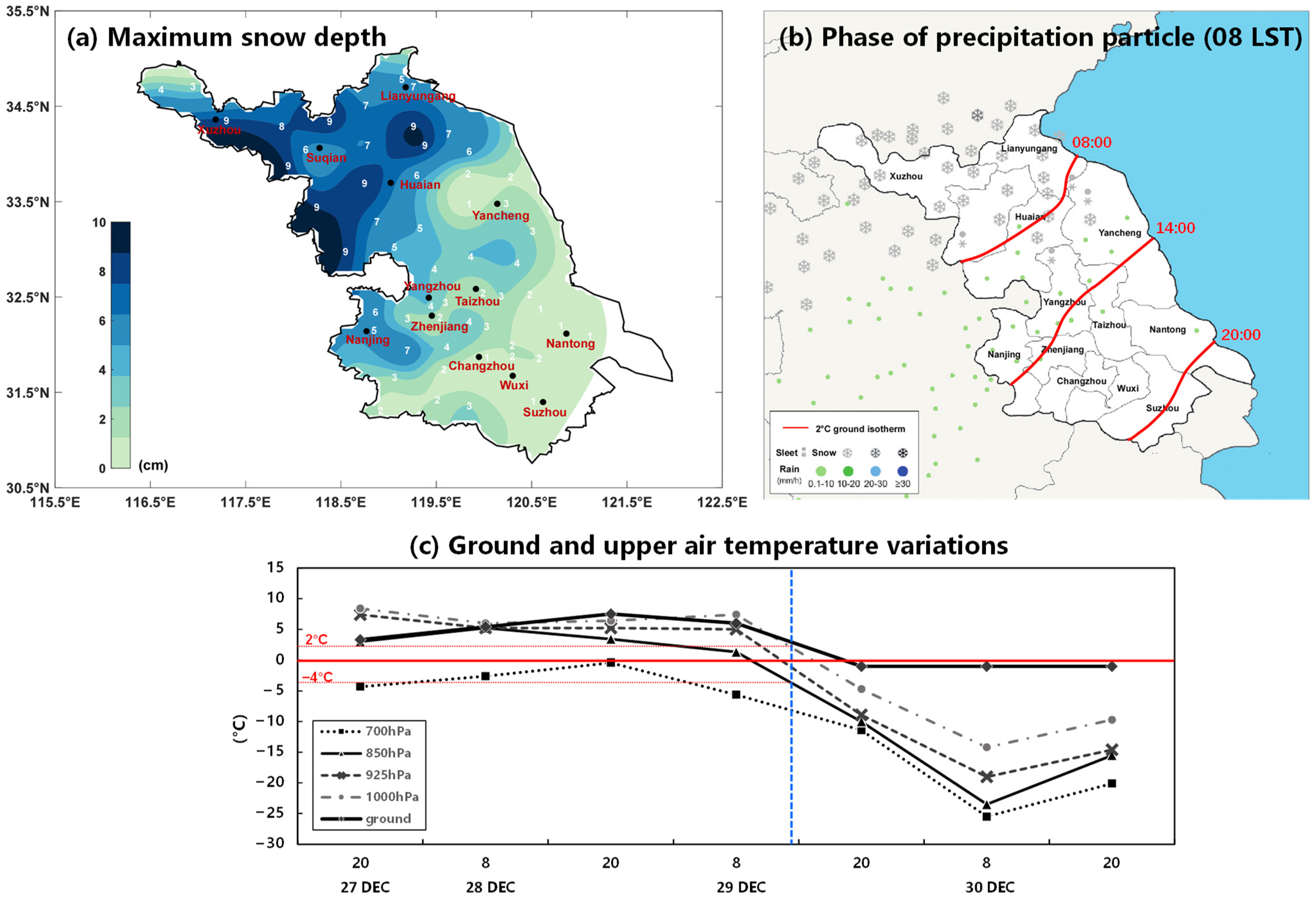
Snowfall occurred throughout the province on 29 December 2020, with blizzard snow in the areas along the Huai River and its northern parts and heavy snow in the areas between the Yangtze and Huai Rivers and along the western parts of the Yangtze River. Other areas experienced light to moderate snowfall (Figure 4a). From December 28 to 30, 2020, the maximum snow depth was observed as in Figure 4b, with 23 counties (cities or districts) along and to the north of the Huai River having a snow depth exceeding 5 cm. The maximum snow depth reached 9 cm in Xuzhou, Xinyi, Suining, Guanyun, Guannan, Xuyi, Siyang, Sihong, and Xiangshui. The fast accumulation and slow melting of snow led to hazards such as icy roads, which had significant impacts on agriculture, transportation, and other industries. During this snowstorm event, as cold air moved southward and ground temperatures gradually dropped, there was a transition from light rain to snow, from the northern Jiangsu Province to the south. The precipitation phase changed from liquid to solid, indicating a representative snowstorm case for us to investigate.
Figure 4b shows the observed rain–snow phase on 29 December at 08 LST from the ground observation stations. The 2 °C isotherm line (red solid line) is oriented in a northeast–southwest direction along the Huai River region. Pure snow is observed to the north of the 2 °C isotherm line while near the 2 °C isotherm line, snowflakes, rainfall, and sleet are observed. On the southern side of the 2 °C isotherm line, rainfall is mainly observed. Figure 4b also shows the trend of the 2 °C isotherm line moving southward, located in the Jianghuai region at 14 LST and in the southeastern part of Jiangsu Province at 20 LST. As the 0–2 °C ground temperature range is most suitable for the occurrence of snow in Jiangsu Province, the 2 °C isotherm line can indirectly represent the rain–snow boundary.
Variations in temperature at the ground and upper layers at Sheyang station showed that the surface temperature at the station first rose and then fell (Figure 4c). From 08 LST on 29 December, the temperature at each layer began to decrease significantly, with a relatively fast cooling rate. At 08 LST on 29 December, the ground temperature was 7.5 °C, the temperature at 925 hPa was 5 °C, and the temperatures at 850 hPa and 700 hPa were 1.3 °C and −5.6 °C, respectively. At this time, Sheyang (northeast of Yancheng) was mainly experiencing rainfall. As the cold air moved southward, the range and intensity of snowfall expanded towards the southeast. Around 14 LST, the ground temperature dropped to 2 °C, and snowfall began near the Sheyang area. In the evening of 29 December, the rain–snow boundary moved southwards to the southern Jiangsu area and the atmospheric temperature continued to decrease above the Sheyang station. At 20 LST on 29 December, the temperatures at 700 hPa, 850 hPa, and 925 hPa were −11 °C, −10 °C, and −8.9 °C, respectively while the temperature at 1000 hPa was −4.7 °C and the ground temperature was −1 °C. Both low-level and ground temperatures were below 0 °C, favoring the accumulation of snow on the ground. During the snowfall period, the strongest snowfall in the Huai River region occurred from the afternoon to the night of 29 December while the strongest snowfall between the Jianghuai region and the western areas along the Yangtze River occurred during the night. Snowfall gradually ceased from north to south from the morning to the afternoon on December 30th.

3.2.2. Polarimetric Parameters Features

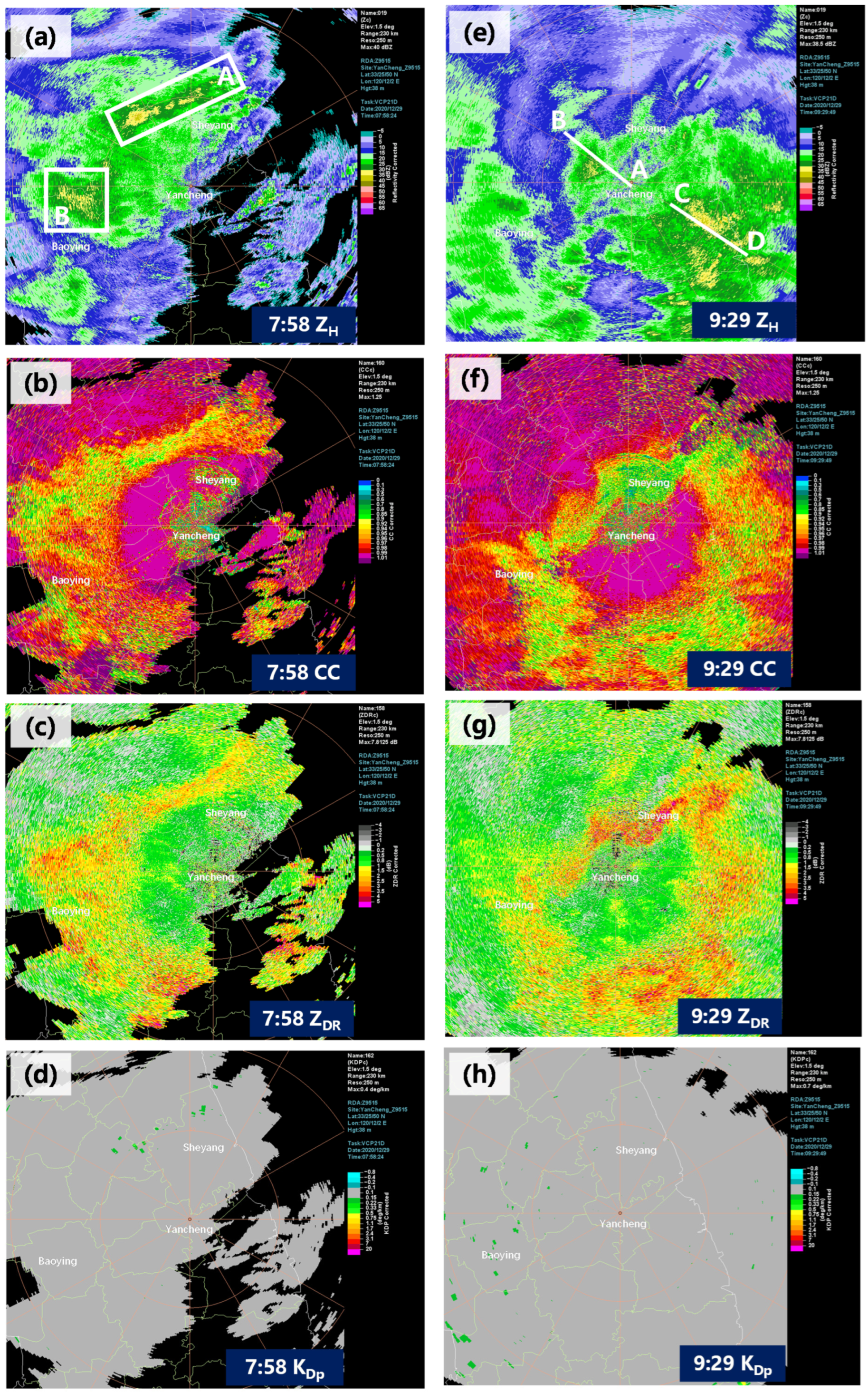
Figure 5 shows the ZH, CC, ZDR, and KDP products at a 1.5° elevation angle from the Yancheng dual-polarization Doppler radar at 7:58 LST and 09:29 LST on 29 December 2020. At 7:58 LST, the horizontal basic reflectivity at the 1.5° elevation angle shows a gradually forming arc-shaped echo band to the northwest of Yancheng, about 40–50 km away (Figure 5a). The echo reaches above 35 dBZ, which is about 10 dBZ higher than the surroundings. A bright band of the zero-degree layer, about 10 km in width, gradually forms in this area (marked as box A in Figure 5a). The zero-order lag correlation coefficient CC product clearly shows that the CC values corresponding to the bright band of the zero-degree layer are more noisy and generally smaller, ranging from 0.72 to 0.93 (Figure 5b). This indicates that the particle properties in this bright band area are diverse and irregular in size and shape. The ZDR products also reveals that the ZDR values in area A are larger (above 2 dB) and significantly higher than in the surrounding areas (Figure 5c). The values in some areas even reach 3.2 dB, indicating the presence of columnar ice crystals with a higher ratio of long to short axes and wet snow in this area. Therefore, we infer that area A is the melting layer, and the radar indicates its height to be approximately 1.7 km.
Interestingly, at 50–80 km to the west of the Yancheng dual-polarization radar, there is another obvious area with high reflectivity factor values, also reaching around 35 dBZ (marked as box B in Figure 5a). However, the PPI charts of CC show that the CC values in area B are generally greater than 0.95, significantly higher than the surroundings, and the ZDR values are also below 1.0 dB, slightly lower than the surroundings. These are different from the polarimetric parameters in area A. Based on the preliminary inference of the melting layer height (Section 3.2.1) and the sounding observations (1.726 km), we comprehensively conclude that the main particle type in area B at a height of 2 km is dry snow. The two echo areas with the same reflectivity factor of 35 dBZ on the basic reflectivity PPI charts can be clearly distinguished based on the dual-polarization parameters. In area A, the reflectivity factor increases due to the melting of snowflakes and ice crystals near the zero-degree layer during the falling process. In area B, the complex refractive index of ice particles with the same radius is smaller than that of water droplets under Rayleigh scattering, resulting in its scattering ability being only a fraction of that of water droplets. However, after the melting of ice crystals or snow, due to the surface tension, they quickly transform into spherical water droplets, increasing the falling speed. This leads to a decrease in the number of precipitation particles per unit volume compared to the rain, resulting in a higher particle number density and larger backscattering cross-section in the dry snow area, causing ZH to exceed the rain area. The dual-polarization parameters are of great reference value for further determining the particle phase in precipitation echoes.
As the cold air gradually moves southward, the atmospheric temperature decreases from the ground to upper levels, and the height of the melting layer also decreases. Snowfall begins to occur in the northern part of Yancheng. The PPI charts of the zero-lag correlation coefficient (CC) product at 8:32 LST and 8:44 LST show that the melting layer gradually changes from an arc shape to a circular shape, and the zero-degree bright band moves southeastward.
At 9:29 LST, the bright band at the zero-degree layer, which was originally in the northern part of Yancheng, has disappeared. Echoes with reflectivity values greater than 30 dBZ have moved southeastward to 30–80 km southeast of the Yancheng radar. In Figure 5b, the area with noisy low CC values, previously in the northern part of Yancheng, gradually increases, with most areas exceeding a value of 0.98. The low CC value area, indicating the decreasing melting layer, changes from a ring shape to a semi-circle, and the CC values rapidly decrease to around 0.81 at 50–100 km southeast of the Yancheng radar (Figure 5f). The ZDR product shows a similar trend to the CC product, with the high ZDR values gradually moving southeastward. In the circular area in the figure, the ZDR values reach 3.2 dB or higher. The KDP products at 7:58 LST and 9:29 LST show little change, with most areas having a KDP value of 0.0 and only some areas reaching 0.2 (° km−1). Therefore, the KDP product has little significance in identifying the melting layer.
Then, the surface temperature in Yancheng continues to decrease. The surface temperature has dropped to around 0 °C at around 15 LST. Snowfall is observed within the detection range of the dual-polarization radar in Yancheng. At 15:01, the basic reflectivity factor has weaker echoes, mostly ranging from 15 to 20 dBZ. This is mainly due to the fact that after the snowfall, the backscattering of particles detected by the radar is weaker. The particles are more uniform, resulting in lower basic reflectivity factors, usually below 30 dBZ. The CC values within the radar detection area are mostly above 0.98, and the ZDR product shows that most areas have a ZDR value below 1 dB.
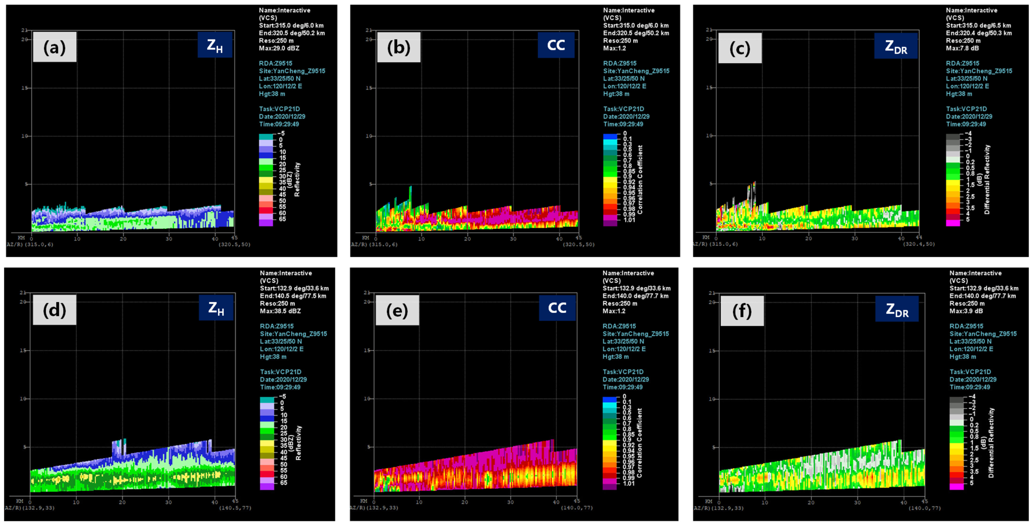
To determine the height of the melting layer more clearly, we conducted a profile along the AB and CD line as shown in Figure 5e. The vertical profile of the reflectivity factor (Figure 6a) shows that the reflectivity factor is generally below 30 dBZ throughout the layer, and the echo develops below 1.5 km. Along the AB line, the vertical profile of the CC product (Figure 6b) reveals a distinct low-value band near the lower edge of radar detection, with CC values mostly below 0.93. In some areas, the center of the low-value band reaches 0.66, and its height is mostly below 1.1 km. The boundary between the low-value band and the relatively high CC values (CC > 0.98) above is horizontally straight, indicating that this low-value area corresponds to the melting layer. Additionally, there is another low-value area in the CC profile at a height of 2.1 km, located 15–22 km from the radar, indicating mixed-phase particles coexisting. The descent of these mixed-phase particles contributes to a significant temperature drop at the surface, thus providing positive feedback.
The vertical profile of the ZDR product along the AB line (Figure 6c) shows a belt-shaped high-value zone at a height of 0.8–0.9 km, with some areas reaching a maximum value of 4.0 dB or higher. Above the high-value zone, there is a low-value area in ZDR (with the ZDR being less than 0.8 dB), and the boundary between them is clear and horizontally straight. Based on the analysis above, it can be concluded that the height of the melting layer along the AB line at 9:29 LST was mostly below 1.1 km, showing a noticeable decrease compared to 08 LST (when the sounding recorded a height of 1.726 km). This is consistent with the temperature change and rain-to-snow timing in the northern part of Yancheng.
At 9:29 LST, the PPI chart of the basic reflectivity factor from the Yancheng dual-polarization radar shows echoes with a reflectivity above 30 dBZ, located 30–80 km southeast of the radar (Figure 5e). Ground-based data show that the surface temperature in this area, including Dafeng, Dongtai, and Xinghua, is around 8 °C, indicating a precipitation phase of light rain. By analyzing the basic reflectivity factor along the CD line in Figure 5e, we can observe a distinct high-value band of the reflectivity factor above 30 dBZ (Figure 6d). Compared with the upper and lower areas, the reflectivity factor is approximately 10 dBZ higher in this high-value band, which is located at a height of 1.3–2.0 km, with the center of intensity being mainly at a height of around 1.7 km, clearly reflecting the bright band of the melting layer level. The vertical profile of the CC product along the CD line shows a low-value band at 1.2–2.2 km, with CC values ranging from 0.76 to 0.92. The center of the lowest CC value is located at an altitude of approximately 1.71 km (Figure 6e). Above 2.6 km and below 1 km, the CC values are generally large, being mostly above 0.98. Therefore, the height of the melting layer can also be accurately determined to be around 1.7 km from the CC profile. The vertical profile of the ZDR product along the CD line shows that the values near 1.2–2.0 km are slightly larger than those in the upper and lower layers, mostly above 1.6 dB, while the ZDR values in the upper and lower layers are mostly below 1 dB, indicating that the particle size in this area is larger horizontally than vertically (Figure 6f). The center of the high ZDR values is at approximately 1.6 km, which is consistent with the center of the low CC values. Additionally, above the high ZDR band, there is a gray band of low ZDR values ranging from −0.1 to 0.3 dB at approximately 2.1–4.0 km and with a thickness of about 2 km. Considering the environmental temperature, this gray band of ZDR indicates the coexisting of dry snow and ice crystals.
The above analysis has compared the vertical structure of the dual-polarization radar parameters in the northern and southern regions of Yancheng at 9:29 LST. As the cold air moves southward, the melting layer in the northern region of Yancheng at 9:29 LST shows a significant decrease compared to that at 08:00 LST, with the height being mostly below 1.1 km. In the southern region of Yancheng where the cold air has not arrived, the height of the melting layer remains relatively high, mostly around 1.7 km, which is consistent with the observed value at the Sheyang station (08 LST). This indicates that the use of dual-polarization radar parameters is generally accurate in determining the height of the melting layer.

3.2.3. ML and HCL Products

The above statistical analysis shows that the height and variation trend of the melting layer can be subjectively identified in a relatively accurate manner through the ZH, CC, and ZDR products of the dual-polarization radar. In fact, the dual-polarization radar also provides a melting layer (ML) product through objective algorithms, and its specific principles and characteristic lines are explained in Section 2.3.2.
Figure 7a,b show the CC and ML products of the Yancheng dual-polarization radar at 1.5° and 2.4° elevation angles at 8:26 LST. In Figure 7a, the four contour lines appear as approximately concentric circles, with BE (inner dashed line) located 22–32 km away from the radar, BC (inner solid line) located 30–41 km away, TC (outer solid line) located 62–72 km away, and TE (outer dashed line) located 82–96 km away. In the ML product, at a 2.4° elevation angle, the four lines are much closer, with BE (inner dashed line) located 17–24 km away from the radar, BC (inner solid line) located 20–29 km away, TC (outer solid line) located 41–48 km away, and TE (outer dashed line) located 49–58 km away (Figure 7b). This indicates that the temperature distribution in the atmosphere measured using the dual-polarization radar is relatively uniform.
By overlaying the ML product on the CC product, it can be seen more clearly that the CC values between the two solid circles are smaller and that the low-value area is basically on the same concentric circle. This is particularly evident in the CC and ML overlay plot at the 2.4° elevation angle, where the circular area with low CC values is almost entirely between the BC and TC lines (Figure 7b). Since the possibility of heavy raindrops can be largely excluded in winter, it can be inferred that this area is the melting layer region where liquid and solid particles coexist and the particle properties are more complex, resulting in smaller CC values.
With the help of the heights from the 08 LST Sheyang station sounding data and the four solid or dashed lines, the accuracy of the ML products can be further assessed. From the 8:26 LST ML products from the Yancheng radar, the height of BE is approximately 0.8 km, corresponding to the temperature of about 5 °C on the sounding chart. The height of BC is approximately 1.1 km, with the temperature being about 3.2 °C. The height of TC is approximately 2.0 km, with the temperature being about −1.5 °C. The height of TE is approximately 2.8 km, with the temperature being about −6.1 °C. The zero-degree layer height derived from the Sheyang station sounding data at 08 LST is at 1.762 km, located between the two solid white lines BC and TC. By increasing the elevation angle to 2.4°, as shown in Figure 7b, the height of BE is approximately 0.9 km, with the temperature being about 4.2 °C. The height of BC is approximately 1.2 km, with the temperature being about 2.9 °C. The height of TC is approximately 2.1 km, with the temperature being about −1.6 °C. The height of TE is approximately 2.4 km, with the temperature being about −5.2 °C. Similarly, it can be observed that the zero-degree layer is located between the two solid white lines, BC and TC, and is closer to TC (outer solid line).
In the figure, at 9:29 LST on 29 December, with the cold air moving southward, the distances between TC (outer solid line)/TE (outer dashed line) and the radar station remain relatively unchanged compared to those at 8:26 LST, basically being around 70 km (TC) and 94 km (TE). However, the distances between BE / BC and the radar station have changed significantly compared to those at 8:26 LST, being approximately 13 km (BC) and 10 km (BE), and the corresponding heights have also decreased to 0.4 km (BC) and 0.3 km (BE). This indicates a decreasing trend in the melting layer height compared to that at 8:26 LST.
At 15:01 LST, the ground temperature in Yancheng drops to around 0 °C, and the precipitation phase becomes pure snow. At the 1.5° elevation angle, in the ML product from the dual-polarization radar, the BE and BC lines are still visible but very close to the radar station, making them almost indistinguishable (Figure 7d). The TC and TE lines in the outer circle can still be seen, located about 25 km from the radar station, with the height continuously decreasing to below 1 km. However, the melting layer is near the ground now, and there is no melting layer in the upper atmosphere. Combined with ZH, CC, and other radar products, there may be some judgment error in the melting layer in the outer circle.
By comparing the ML products of the dual-polarization radar and real-time sounding data at different stages, it can be found that the ML products are more accurate when the melting layer is higher. The real height of the zero-degree layer is located between the BC (inner solid line) and TC (outer solid line), and it is closer to the outer solid line TC. The ML products can reflect the changes in the descent of the melting layer well. However, when the melting layer is low or the ground temperature is below 0 °C, and there is no melting layer in the atmosphere, the dual-polarization radar may mistakenly identify clutter near the radar as the melting layer, resulting in deviations in the determination of the melting layer height by the ML products. For example, for the 13 December 2020, 29 December 2020 (a), and 28 January 2022 snowfall events, the heights of BE and BC cannot be correctly identified. In conclusion, by using the polarization parameters, such as CC, ZDR, and KDP, observed by the dual-polarization radar and objective products of the melting layer, the subjective and objective determination of winter snowfall and the melting layer can be accurately made, thereby determining the properties of rain and snow particles in the atmosphere and identifying the phase of ground rain and snow particles.
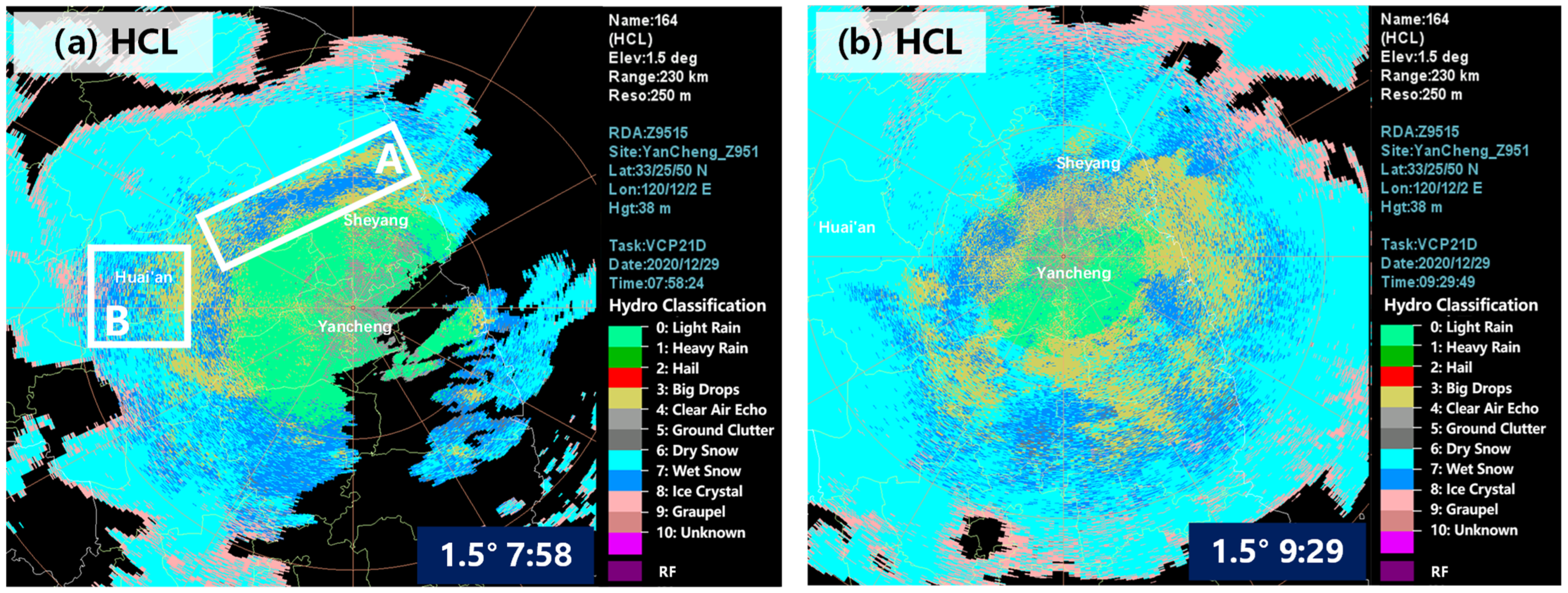
Furthermore, according to the fuzzy-logic classification method described in Section 2.3.2, the dual-polarization radar can infer and generate objective hydrometeor classification (HCL) products based on the criteria to determine the properties of precipitation particles in the atmosphere. Figure 8 shows the specific performance of the HCL products at 7:58 LST and 9:29 LST on 29 December 2020 (b). Comparing the HCL products with the subjective comprehensive judgments at the two moments (Section 3.2.2), at 7:58 LST, the HCL products from the Yancheng dual-polarization radar at a 1.5° elevation angle show that in the area 50 km north of the Yancheng radar, the HCL products are mainly displayed as dry snow; within 40 km, they are mainly identified as light rain, and in the melting layer area (area A) between 40 and 50 km, the HCL products are identified as comprising a mixture of wet snow and large raindrops (Figure 8a). Overall, the objective HCL products generated by the dual-polarization radar are consistent with the subjective judgments in identifying the phase attributes of precipitation particles. However, in the melting layer area (area A in Figure 8a), the HCL products also identify large raindrops, which are mainly located in the outer layer of the melting layer. This identification does not correspond to the characteristics of winter precipitation and is considered as misidentification. The main reason may be that the solid precipitation particles in the melting layer gradually melt in the outer layer after entering the melting layer, and they absorb surrounding ice crystals or snowflakes during the ascent, resulting in a flatter particle shape and a higher reflectivity factor, which causes the radar to misidentify the precipitation particles in that area.
In area B, located 50–80 km west of the Yancheng radar in Figure 8a, the previous analysis has mentioned that the polarization parameters in area B are significantly different from those in area A. The height in this area is above the melting layer, and the comprehensive judgment indicates that dry snow is the dominant precipitation type in this area. The HCL products from the Yancheng radar also identify most of the precipitation particles in this area as dry snow, which is consistent with the subjective comprehensive judgment.
At 9:29 LST, the melting layer gradually lowers at a 1.5° elevation angle of the Yancheng radar. The low-CC-value area changes from circular to arc-shaped and is located to the southeast of the radar station (Figure 5e). As shown in the HCL products, most of the areas outside a range of 50 km northwest to the radar station are identified as having dry snow while most of the areas within a range of 30 km northwest to the radar station are still identified as having wet snow and large raindrops (Figure 8b). In the range of 30–50 km southeast of the radar station, which is below the height of the melting layer, HCL products are identified as light rain. This is consistent with the polarization parameters, such as CC, ZDR, KDP, and the subjective analysis of the melting layer objective product observed by the dual-polarization radar. It is also consistent with the surface temperature and ground observations. At 10 LST, the Binhai and Lianshui stations observe light snow (50 km northwest of Yancheng) while the Funing and Jianhu stations are still experiencing light rain (30 km northwest of Yancheng), and the Dafeng station is experiencing light rain (30–50 km southeast of Yancheng).
Based on the comparison and verification above in this case (and seven other cases), we believe that the objective hydrometeor classification (HCL) products of the dual-polarization radar accurately identify the phase attributes of precipitation particles in the atmosphere during winter snowfall. HCL can be used to quickly determine and identify the particle phase in the atmosphere in daily forecasts. It is particularly important to note the following:
  • The particles detected by S-band radars in the air are not directly the precipitation particles that fall to the ground, so it is necessary to distinguish them from the properties of ground precipitation particles in real time to avoid interference.
  • In significant or long-duration rain-to-snow transition processes, the HCL product can accurately identify the phase attributes of atmospheric particles, including dry snow above the melting layer, light rain below the melting layer, and wet snow and ice crystals within the melting layer. However, in cases where the rain-to-snow transition is not significant or the duration is short, due to the low height of the zero-degree layer, with the melting layer being mostly below 1 km, weak wet snow is only identified near the radar station, and the rest of the PPI shows a large area identified as dry snow.

4. Summary and Conclusions

In this study, a statistical analysis of the dual-polarization parameters and radar detection products of eight snowstorm events in Jiangsu Province from 2020 to 2022 was investigated. We specifically focused on the detailed analysis of the precipitation phase transition on 29 December 2020 in Jiangsu. The study also discussed the precipitation particle properties at the melting layer height. Meanwhile, we verified the application of radar secondary products. The main conclusions are as follows.
Based on the statistics of dual-polarization radar parameters during the winter rain–snow transition stages in Jiangsu, ZH ≥ 27 dBZ, CC ≤ 0.93, and ZDR ≥ 1.0 dB are important indicators for determining the melting layer while the KDP threshold indicator is relatively unclear. During the processes where there is a clear rain-to-snow transition, the height of the melting layer level is generally above 1 km. It is recommended to use the subjective identification of the melting layer height based on dual-polarimetric parameters. However, for those processes with lower ground temperatures before the precipitation, one should be more cautious when using dual-polarimetric parameters to determine the melting layer.
In the case of 29 December 2020, two strong echoes are clearly distinguished on the PPI charts of ZH. The differences in particles within the echoes can be clearly identified through dual-polarization parameters. The low-value areas of CC basically correspond to the location of the melting layer. It is recommended to use the profile chart of polarization parameters to subjectively identify the height of the melting layer at different distances from the radar, thereby determining the phase of the precipitation particles.
In addition, the ML products show that the actual zero-degree level height is located between the BC (inner solid line) and TC (outer solid line), with a closer distance to the outer solid line. The accuracy of ML products is higher when the melting layer is higher, and ML products can reflect the changes in the descending trend of the melting layer well. The dual-polarization radar HCL products based on fuzzy-logic hydrometeor classification algorithms can basically determine the properties of particles in the atmosphere correctly, and they have certain reference value for forecasters’ subjective judgment of precipitation intensity and the determination of the rain–snow phase transition. However, cautions should be taken when using polarimetric parameters to determine the height of the melting layer during snowfall processes with lower surface temperatures.
Different from prior research on precipitation or hail, the observation data from the upgraded seven dual-polarimetric S-band radars in Jiangsu Province were used to statistically analyze snowfalls in winter. In addition, the detailed discussion that was conducted both on the PPI and RHI charts of the radar parameters could significantly demonstrate the advantages of dual-polarization radars in snow monitoring. We have evaluated, for the first time, the application of dual-polarization radar secondary ML products and HCL products in precipitation phase identification in Jiangsu Province. Compared with previous studies [64,65], it is recommended to estimate the height of the melting layer under different weather systems or in different empirical algorithms with more sufficient snowfall cases in further research. After the cancellation of the routine manual observation of snowfall, our research can surely enhance forecasters’ confidence for monitoring and warning for snowstorms by using dual-polarization radars.

Author Contributions

Conceptualization, L.W. and Y.W.; methodology, L.W. and M.L.; software, Y.W.; investigation, L.W.; resources, Y.W.; data curation, W.C.; writing—original draft preparation, L.W.; writing—review and editing, L.W.; visualization, M.L.; supervision, Y.W. and C.L.; project administration, W.C.; funding acquisition, C.L. All authors have read and agreed to the published version of the manuscript.

Funding

This research was jointly supported by the Open Foundation of China Meteorological Administration Hydro-Meteorology Key Laboratory Projects (Grant No. 23SWQXZ002), Youth Innovation Team of China Meteorological Administration (CMA2023QN06), Key Research and Development Plan of Jiangsu Province (BE2023766, BE2022851), CMA “Open Bidding for Selecting the Best Candidates” Project (CMAJBGS202212), and Basic Research Fund of CAMS (2021Z003).

Institutional Review Board Statement

Not applicable.

Informed Consent Statement

Not applicable.

Data Availability Statement

The data presented in this study are available on request from the corresponding author. The data are not publicly available due to privacy concerns.

Acknowledgments

We acknowledge the Jiangsu Meteorological Observatory for providing surface meteorological observation data and dual-polarization radar data.

Conflicts of Interest

The authors declare no conflicts of interest.

References

  1. Chen, L.F. Comparison study of two similar rain and snow processes in South China. Meteorol. Mon. 2007, 33, 68–75. [Google Scholar] [CrossRef]
  2. Liu, J.Y.; Gu, S.N.; Xu, D.F. Simulation study on precipitation phase state in two snowfall processes of south China. Plateau Meteorol. 2013, 32, 179–190. [Google Scholar] [CrossRef]
  3. Shi, H.R.; Li, F.W.; Wu, L.; Jin, L.J. Analysis on Observations of Precipitation Phase Changes Using Wind Profile Radar Data. Meteorol. Mon. 2014, 40, 1259–1265. [Google Scholar] [CrossRef]
  4. Zhang, C.Y. Analysis of Storm Snow Weather Process Based on Wind Profile Radar Data. Meteorol. Environ. Sci. 2016, 39, 80–85. [Google Scholar] [CrossRef]
  5. Zheng, L.N.; Li, T.; Sun, Q.; Tian, X.S. Analysis on transition of precipitation type and causes of two snowstorms over the middle and lower reaches of the Yellow River in February 2021. J. Mar. Meteorol. 2022, 42, 48–56. [Google Scholar] [CrossRef]
  6. Hu, L.; Liu, J.; Dong, G.H.; Yi, X.Y.; Yang, X.J.; Sun, M.N. Analysis on the Circulation Situation and Radar Characteristics of Snowstorm in Tianjin City. Meteorol. Environ. Sci. 2020, 43, 34–42. [Google Scholar] [CrossRef]
  7. Duan, Y.H.; Wang, W.; Tian, G.Z.; Zhang, N. Comparison of Two Rain to Heavy Snowstorm Weather Processes Under the Similar Weather Situation in Northern Part of North China. J. Arid Meteorol. 2013, 31, 784–789. [Google Scholar] [CrossRef]
  8. Lu, B.H.; Yang, Q.; Gao, S.Y.; Han, J.W.; Yan, Q.; Liang, H.; Su, H.; Liu, S. Doppler Radar Echo Features About Two Kinds of Snowstorm Weather Process. J. Arid Meteorol. 2016, 34, 836–840. [Google Scholar] [CrossRef]
  9. Pei, Y.J.; Wang, F.X.; Zhang, Y.X.; Wang, L.R. Analysis on Doppler Radar Feature of Snowstorm in Hebei in Late Autumn of 2009. Plateau Meteorol. 2012, 31, 1110–1118. [Google Scholar]
  10. Jiang, N.C.; Hu, W.; Shao, Y.; Zhou, S.X. Analysis of Characteristics of Precipitation Particle on Heavy Rain Snow Process in Dabie Mountain in Anhui Province. Meteorol. Mon. 2010, 36, 79–84. [Google Scholar] [CrossRef]
  11. Matrosov, S.Y.; Clark, K.A.; Kingsmill, D.E. A Polarimetric Radar Approach to Identify Rain, Melting-Layer, and Snow Regions for Applying Correction to Vertical Profiles of Reflectivity. J. Appl. Meteorol. Climatol. 2007, 46, 154–166. [Google Scholar] [CrossRef]
  12. Kumjian, M.R.; Ryzhkov, A.V.; Reeves, H.D.; Schuur, T.J. A Dual-Polarization Radar Signature of Hydrometeor Refreezing in Winter Storms. J. Appl. Meteorol. Climatol. 2013, 52, 2549–2566. [Google Scholar] [CrossRef]
  13. Thompson, E.J.; Rutledge, S.A.; Dolan, B.; Chandrasekar, V. A Dual-Polarization Radar Hydrometeor Classification Algorithm for Winter Precipitation. J. Atmos. Ocean. Technol. 2014, 31, 1457–1481. [Google Scholar] [CrossRef]
  14. Kaltenboeck, R.; Ryzhkov, A. A freezing rain storm explored with a C-band polarimetric weather radar using the QVP methodology. Meteorol. Z. 2017, 26, 207–222. [Google Scholar] [CrossRef]
  15. Zrnic, D.S.; Ryzhkov, A.; Straka, J.; Liu, Y.D.; Vivekanandan, M.F. Testing a procedure for automatic classification of hydrometeor types. J. Atmos. Ocean. Technol. 2001, 18, 892–913. [Google Scholar] [CrossRef]
  16. Tyynel, J.; Chandrasekar, V. Characterizing falling snow using multifrequency dual-polarization measurements. J. Geophys. Res. 2014, 119, 8268–8283. [Google Scholar] [CrossRef]
  17. Ryzhkov, A.; Zrnic, D.; Brandes, E.; Vivekanandan, J.; Huang, G. Characteristics of hydrometeor orientation obtained from radar polarimetric measurements in a linear polarization basis. In Proceedings of the IEEE 1999 International Geoscience and Remote Sensing Symposium, Hamburg, Germany, 28 June–2 July 1999; pp. 702–704. [Google Scholar] [CrossRef]
  18. Liu, H.P.; Chandrasekar, V. Classification of hydrometeors based on polarimetric radar measurements: Development of fuzzy logic and neuro-fuzzy systems, and in situ verification. J. Atmos. Ocean. Technol. 2000, 17, 140–164. [Google Scholar] [CrossRef]
  19. Straka, J.M.; Zrnic, D.S.; Ryzhkov, A.V. Bulk hydrometeor classification and quantification using polarimetric radar data: Synthesis of relations. J. Appl. Meteorol. 2000, 39, 1341–1372. [Google Scholar] [CrossRef]
  20. Sun, S.S.; Sun, Y.; Xu, T.T.; Wang, H.; Yang, C.F.; He, P.C. Multi-source observational characteristics of precipitation phase during extreme snowstorm Shandong on 7 November 2021. Meteorol. Mon. 2023, 49, 830–842. [Google Scholar] [CrossRef]
  21. Wang, J.; Wang, W.Q.; Wang, H.; Zhang, Q.C.; Gong, D.L.; Yang, X.B. Hydrometeor particle characteristics during a late summer hailstorm in northern Shandong. J. Appl. Meteorol. Sci. 2021, 32, 370–384. [Google Scholar] [CrossRef]
  22. Feng, L.; Xiao, H.; Sun, Y. A study on hydro meteor classification and application based on X-band dual-polarization radar measurements. Clim. Environ. Res. 2018, 23, 366–386. [Google Scholar] [CrossRef]
  23. Du, M.Y.; Liu, L.P.; Hu, Z.Q.; Yang, C. An analysis of dual-linear polarimetric Doppler radar data quality. Acta Meteorol. Sin. 2013, 71, 329–332. [Google Scholar] [CrossRef]
  24. Zhang, L.; Yang, H.P. Non-precipitation identification technique on S-band WSR-88D polarization weather radar. Meteorol. Mon. 2018, 44, 665–675. [Google Scholar] [CrossRef]
  25. Rasmussen, R.M.; Dixon, M.; Vasiloff, S.; Hage, F.; Mei, X. Snow Nowcasting Using a Real-time Correlation of Radar Reflectivity with Snow Gauge Accumulation. J. Appl. Meteorol. 2003, 42, 20–36. [Google Scholar] [CrossRef]
  26. Rasmussen, R.M.; Hills, A.; Landolt, S.; Knight, C. Results of Holdover Time Testing of Type IV Anti-icing Fluids with the Improved NCAR Artificial Snow Generation System; Office of Aviation Research: Washing, DC, USA, 1999.
  27. Hiromu, S.; Teruyuki, K.; Kazuo, S.; Masanori, Y.; Kenichi, K.; Masayuki, M. Analytical and Numerical Studies of a Quasi-stationary Precipitation Band Observed over Kanto Area Associated with Typhoon 9426 (Orchid). J. Meteorol. Soc. Jpn. 1999, 77, 929–938. [Google Scholar] [CrossRef]
  28. Yoshimoto, N.; Fujiyoshi, Y.; Takeda, T.A. Dual-Doppler Radar Study of Longitudinal Mode Snow Bands. Part II: Influence of the Kinematics of a Longitudinal Mode Snow Band on the Development of adjacent Snow Band. J. Meteorol. Soc. Jpn. 2000, 78, 381–403. [Google Scholar] [CrossRef]
  29. Cram, T.; Montgomery, M.; Hertenstein, R.F. Early Evolution of Vertical Vorticity in a Numerically Simulated Idealized Convective Line. J. Atmos. Sci. 2002, 59, 2113–2127. [Google Scholar] [CrossRef]
  30. Toshi, H.; Yasumi, N. Riming Growth Process Contributing to the Formation of Snowfall in Orographic Areas of Japan Facing the Japan Sea. J. Meteorol. Soc. Jpn. 1999, 77, 101–115. [Google Scholar] [CrossRef]
  31. Eito, H.; Kato, T.; Yoshizaki, M.; Adachi, A. Numerical Simulation of the Quasi-stationary Snow Band Observed over the Southern Coastal Area of the Sea of Japan on 16 January 2001. J. Meteorol. Soc. Jpn. 2005, 83, 551–576. [Google Scholar] [CrossRef]
  32. Andric, J.; Kumjian, M.R.; Zrnic, D.S.; Straka, J.M.; Melnikov, V.M. Polarimetric Signatures Above the Melting Layer in Winter Storms: An Observational and Modeling Study. J. Appl. Meteorol. Climatol. 2013, 52, 682–700. [Google Scholar] [CrossRef]
  33. Shen, F.; Min, J.; Xu, D. Assimilation of radar radial velocity data with the WRF Hybrid ETKF–3DVAR system for the prediction of Hurricane Ike (2008). Atmos. Res. 2016, 169, 127–138. [Google Scholar] [CrossRef]
  34. Shen, F.; Xu, D.; Min, J.; Chu, Z.; Li, X. Assimilation of radar radial velocity data with the WRF Hybrid 4DEnVar system for the prediction of Hurricane Ike (2008). Atmos. Res. 2020, 230, 104622. [Google Scholar] [CrossRef]
  35. Shen, F.; Xu, D.; Li, H.; Liu, R. Impact of radar data assimilation on a squall line over the Yangtze-Huaihe River Basin with a radar reflectivity operator accounting for ice-phase hydrometeors. Meteorol. Appl. 2021, 28, e1967. [Google Scholar] [CrossRef]
  36. Song, L.; Shen, F.; Shao, C.; Shu, A.; Zhu, L. Impacts of 3DEnVar-Based FY-3D MWHS-2 Radiance Assimilation on Numerical Simulations of Landfalling Typhoon Ampil (2018). Remote Sens. 2022, 14, 6037. [Google Scholar] [CrossRef]
  37. Shu, A.; Shen, F.; Jiang, L.; Zhang, T.; Xu, D. Assimilation of Clear-sky FY-4A AGRI radiances within the WRFDA system for the prediction of a landfalling Typhoon Hagupit (2020). Atmos. Res. 2022, 283, 106556. [Google Scholar] [CrossRef]
  38. Xu, D.; Liu, Z.; Fan, S.; Chen, M.; Shen, F. Assimilating all-sky infrared radiances from Himawari-8 using the 3DVar method for the prediction of a severe storm over North China. Adv. Atmos. Sci. 2021, 38, 661–676. [Google Scholar] [CrossRef]
  39. Zhang, X.; Xu, D.; Li, X.; Shen, F. Nonlinear Bias Correction of the FY-4A AGRI Infrared Radiance Data Based on the Random Forest. Remote Sens. 2023, 15, 1809. [Google Scholar] [CrossRef]
  40. Xu, D.; Zhang, X.; Liu, Z.; Shen, F. All-sky infrared radiance data assimilation of FY-4A AGRI with different physical parameterizations for the prediction of an extremely heavy rainfall event. Atmos. Res. 2023, 293, 106898. [Google Scholar] [CrossRef]
  41. Shen, F.; Song, L.; Li, H.; He, Z.; Xu, D. Effects of different momentum control variables in radar data assimilation on the analysis and forecast of strong convective systems under the background of northeast cold vortex. Atmos. Res. 2022, 280, 106415. [Google Scholar] [CrossRef]
  42. Shen, F.; Song, L.; He, Z.; Xu, D.; Chen, J.; Huang, L. Impacts of adding hydrometeor control variables on the radar reflectivity data assimilation for the 6–8 August 2018 mesoscale convective system case. Atmos. Res. 2023, 295, 107012. [Google Scholar] [CrossRef]
  43. Song, T.; Xu, D.; Shen, F.; Shu, A.; Song, L. Forecast and Analysis of a Rainstorm Case in East China Based on the Blown-Up Theory. Atmosphere 2023, 14, 1508. [Google Scholar] [CrossRef]
  44. Wu, J.Y.; Bi, Y.H.; Sun, Q.; Lü, D.R. Observation and analysis of snowband structure in a process of cyclone frontal snowfall in Beijing with Ka-band and X-band polarized radars. Chin. J. Atmos. Sci. 2021, 45, 931–942. [Google Scholar] [CrossRef]
  45. Liao, X.N.; Zhang, L.N.; He, N.; Lu, B. Analysis on the Mechanism of the 17 March 2012 Precipitation Type Variety in Beijing. Meteorol. Mon. 2013, 39, 28–38. [Google Scholar] [CrossRef]
  46. He, C.F.; Huang, X.X.; Lu, J.J. Comprehensive Analysis on Snow and Freezing-rain Events based on Doppler Weather Radar in Ningbo. J. Appl. Meteorol. Sci. 2009, 20, 767–771. [Google Scholar] [CrossRef]
  47. Wei, W.; Liu, L.P.; Wu, C.; Wang, H.Y.; Zhou, M. Analysis of dual-polarization radar observation during the 5 December 2015 snowfall process in Hangahou. Meteorol. Mon. 2019, 45, 1248–1261. [Google Scholar] [CrossRef]
  48. Yong, J.; Wei, M. Vertical characteristic analysis of cloud phase of dual-polarization radar with snowfall echo. Sci. Technol. Eng. 2019, 19, 46–53. [Google Scholar]
  49. Wu, Y.; Zhao, F.; Kong, Z.L.; Peng, X.Y.; Wang, Y.H.; Ma, H. Feature analysis of the first snowfall in Zhejiang in 2015 by dual-polarization. J. Nanjing Univ. Inf. Sci. Technol. 2018, 10, 103–109. [Google Scholar] [CrossRef]
  50. Tao, R.T. Snow Microphysical Characteristics and Snowfall Estimation in East China Based on a 2D Video Dendrometer and Dual Polarization Radar; Nanjing University: Nanjing, China, 2020. [Google Scholar]
  51. Bechini, R.; Baldini, L.; Chandrasekar, V. Polarimetric radar observations in the ice region of precipitating clouds at C-band and X-band radar frequencies. J. Appl. Meteorol. Climatol. 2013, 52, 1147–1169. [Google Scholar] [CrossRef]
  52. Kennedy, P.C.; Rutledge, S.A. S-band dual-polarization radar observations of winter storms. J. Appl. Meteorol. Climatol. 2011, 50, 844–858. [Google Scholar] [CrossRef]
  53. Yang, Z.X.; Xie, Y.F.; Xiang, Y.; Zhou, S.N. Analysis on dual polarization radar observations of a heavy snowstorm event in Anhui in the beginning of January 2018. Torr. Rain Dis. 2019, 38, 31–40. [Google Scholar] [CrossRef]
  54. Hersbach, H.; Bell, B.; Berrisford, P.; Hirahara, S.; Horányi, A.; Muñoz-Sabater, J.; Nicolas, J.; Peubey, C.; Radu, R.; Schepers, D. The ERA5 global reanalysis. Q. J. R. Meteorol. Soc. 2020, 146, 1999–2049. [Google Scholar] [CrossRef]
  55. Seliga, T.A.; Bringi, V.N. Potential use of radar differential reflectivity measurements at orthogonal polarizations for measuring precipitation. J. Appl. Meteorol. Climatol. 1976, 15, 69–76. [Google Scholar] [CrossRef]
  56. Bringi, V.N.; Chandrasckar, V.; Balakrishnan, N.; Zrnić, D.S. An examination of propagation effects in rainfall on radar measurements at microwave frequencies. J. Atmos. Ocean. Technol. 1990, 7, 829–840. [Google Scholar] [CrossRef]
  57. Sachidananda, M.; Zrnić, D.S. ZDR measurement considerations for a fast scan capability radar. Radio Sci. 1985, 20, 907–922. [Google Scholar] [CrossRef]
  58. Jameson, A.R.; Mueller, E.A. Estimation of propagation-differential phase shift from sequential orthogonal linear polarization radar measurements. J. Atmos. Ocean. Technol. 1985, 2, 133–137. [Google Scholar] [CrossRef]
  59. Testud, J.; Le Bouar, E.; Obligis, E.; Mustapha, A.-M. The rain profiling algorithm applied to polarimetric weather radar. J. Atmos. Ocean. Technol. 2000, 17, 332–356. [Google Scholar] [CrossRef]
  60. Jing, G.F.; Luo, L.; Xiao, H.; Guo, J.; Cui, X.L. Application research of dual-polarization radar in quality control of automatic rain gauge. Meteorol. Mon. 2020, 46, 1189–1198. [Google Scholar] [CrossRef]
  61. Huang, H.; Zhao, K.; Zhang, G.; Glangrande, S.E. A hybrid method to estimate specific differential phase and rainfall with linear programming and physics constraints. IEEE Trans. Geosci. Remote Sens. 2016, 54, 1–16. [Google Scholar] [CrossRef]
  62. Bringi, V.N.; Chandrasekar, V. Principles and Applications of Polarized Doppler Weather Radar; Beijing Meteorological Publishing House: Beijing, China, 2010. [Google Scholar]
  63. Zhang, C.A. User Guide for Dual Polarization Weather Radar Products; Beijing Minshida Radar Co., Ltd.: Beijing, China, 2018. [Google Scholar]
  64. Brandes, E.A.; Ikeda, K. Freezing-level estimation with polarimetric radar. J. Appl. Meteorol. 2004, 43, 1541–1553. [Google Scholar] [CrossRef]
  65. Shusse, Y.; Maesaka, T.; Kieda, K.; Iwanami, K. Polarimetric radar observation of the melting layer in a winter precipitation system associated with a south-coast cyclone in Japan. J. Meteorol. Soc. Jpn. 2019, 97, 375–385. [Google Scholar] [CrossRef]
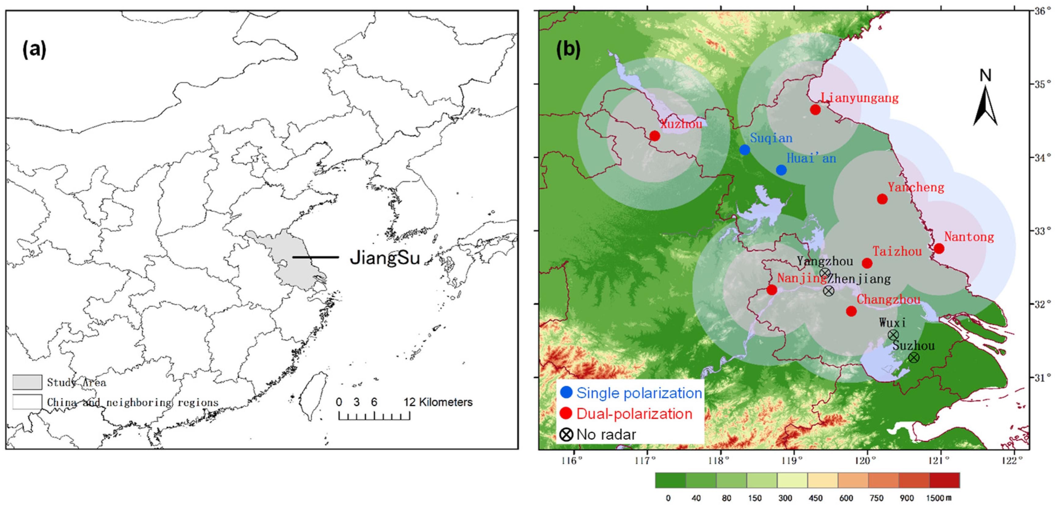
Figure 1. (a) Geographical distribution of the studied area in East China region. (b) Location of Jiangsu Province and distribution of observation stations (intervals between radial circles are 50 km and 230 km).
Atmosphere 15 00321 g001
Figure 2. Sketch map of melting layer (ML) products of dual-polarization radar.
Atmosphere 15 00321 g002
Figure 3. Statistical analysis of (a) horizontal basic reflectivity factor (ZH), differential reflectivity (ZDR), (b) zero-order lag correlation coefficient (CC), and specific differential phase (KDP) of the melting layer during the rain and snow transition from the nearest radar. Values at the tops/bottoms of the bars represent the minimum/maximum values of the corresponding radar parameters.
Atmosphere 15 00321 g003
Figure 4. (a) Distribution of maximum snow depth (unit: cm) during the period from 00 LST 28 December to 00 LST 30 December 2020, (b) phase of precipitation particles at 08 LST on 29 December 2020 from ground-based observation, and (c) variations in temperature (unit: °C) at ground level and in upper air at Sheyann station from 20 LST on 27 December to 20 LST on 30 December 2020 in Jiangsu Province.
Atmosphere 15 00321 g004
Figure 5. (a,e) PPI charts of horizontal basic reflectivity factor (ZH), (b,f) zero-order lag correlation coefficient (CC), (c,g) differential reflectivity (ZDR), and (d,h) specific differential phase (KDP) at 1.5° elevation angle from Yancheng dual-polarization Doppler radar at 7:58 LST and 9:29 LST on 29 December 2020. (Box A and B show the areas with high reflectivity factor values. AB and CD line are marked to show the vertical profile of the reflectivity factor.)
Atmosphere 15 00321 g005
Figure 6. (a) Reflectivity factor, (b) CC, and (c) ZDR along the AB line in Figure 5e. (d) Reflectivity factor, (e) CC, and (f) ZDR along the CD line in Figure 5e at 9:29 LST on 29 December 2020.
Atmosphere 15 00321 g006
Figure 7. Superposition of melting layer (ML) product (contours) and CC (color-filled areas) at 08:26 LST at (a) 1.5° elevation angle and (b) 2.4° elevation angle from Yancheng dual-polarization radar and PPI charts of ML at 1.5° elevation angle at (c) 09:29 LST and (d) 15:01 LST on 29 December 2020.
Atmosphere 15 00321 g007
Figure 8. PPI charts of HCL at 1.5° elevation angle from Yancheng dual-polarization radar at (a) 07:58 LST and (b) 09:29 LST on 29 December 2020. (Box A and B show the areas with high reflectivity factor values.)
Atmosphere 15 00321 g008
Table 1. Information on snowfall processes in Jiangsu Province from 2020 to 2022.
Process
Number
Process DateProcess Time
(LST)
Affected Areas
128 March 202002–08Regions along the Yangtze River and southern Jiangsu Province
213 December 202019–23Regions along the Yangtze River and southern Jiangsu Province
329 December 2020 (a)06–07The Huaibei region
429 December 2020 (b)09–10The Jianghuai region
529 December 2020 (c)13–14Regions along the Yangtze River
629 December 2020 (d)17–20Southern Jiangsu Province
728 January 202216–23Regions along the Yangtze River and southern Jiangsu Province
87 February 202202–20Regions along the Yangtze River and southern Jiangsu Province
Table 2. Judgment criterion based on the fuzzy-logic method for dual-polarization radar (from references [62,63] in the paper).
TypeZH (dBZ)CCZDR (dB)KDP (°·km−1)
L/M Rain5~500.97~1.010.0~6.00.0~1.0
Heavy Rain40~600.95~1.000.5~8.01.0~5.0
Big Drops10~500.92~1.012.5~7.00.0~2.0
Hail45~800.75~1.0−0.3~4.5−2.0~10
Ice Crystals30~550.92~1.01−0.3~2.2−2.0~2.0
Dry Snow25~500.88~0.9850.5~3.0−1.0~0.5
Wet Snow0~250.95~1.01−1.0~5.0−1.0~0.5
Table 3. Melting layer heights obtained from horizontal basic reflectivity factor (ZH), differential reflectivity (ZDR), zero-order lag correlation coefficient (CC), and the actual zero-degree layer heights during 8 snowfall processes from 2020 to 2022.
Process DateMelting Layer Heights Obtained from ZH (km)Melting Layer Heights Obtained from ZDR (km)Melting Layer Heights Obtained from CC (km)Actual Zero-Degree Layer Height
(km)
28 March 20203.03.43.22.13
13 December 20200.90.60.70.70
29 December 2020 (a)1.31.31.21.43
29 December 2020 (b)1.71.81.71.726 *
29 December 2020 (c)2.82.82.72.86
29 December 2020 (d)2.2~2.42.3~2.42.2~2.52.18
28 January 20220.40.40.40.43
7 February 2022///0.2
(In the column of Actual Zero-Degree Layer Height, * represents the actual sounding data (sounding at Sheyang Station at 08:00 29 December 2020) while the remaining data are from ERA5 reanalysis data).
Disclaimer/Publisher’s Note: The statements, opinions and data contained in all publications are solely those of the individual author(s) and contributor(s) and not of MDPI and/or the editor(s). MDPI and/or the editor(s) disclaim responsibility for any injury to people or property resulting from any ideas, methods, instructions or products referred to in the content.