1. Introduction
Hong Kong, a small and densely populated city located in the south China coastal region, is vulnerable to coastal flooding or sea inundation due to storm surges associated with the passage of tropical cyclones (TCs) over the northern part of the South China Sea. Historically, storm surges induced by typhoons in 1906 and 1937 and by Wanda in 1962 have brought severe casualties to the densely populated city [
1]. Some other TCs (e.g., Typhoon Hope in 1979, Typhoon Hagupit in 2008, Super Typhoon Hato in 2017 and Super Typhoon Mangkhut in 2018) also brought severe flooding and damages to Hong Kong during their passage. The combined effect of storm surges, rainfall and overtopping waves has been a major threat causing inundation to a city as shown in various studies, e.g., by Qiang et al. [
2].
Table 1 shows the Hong Kong Observatory (HKO) records of significant storm surge events in Hong Kong.
Due to the complex coastal morphology in Hong Kong, there could be significant differences in storm surges at different locations of the territory.
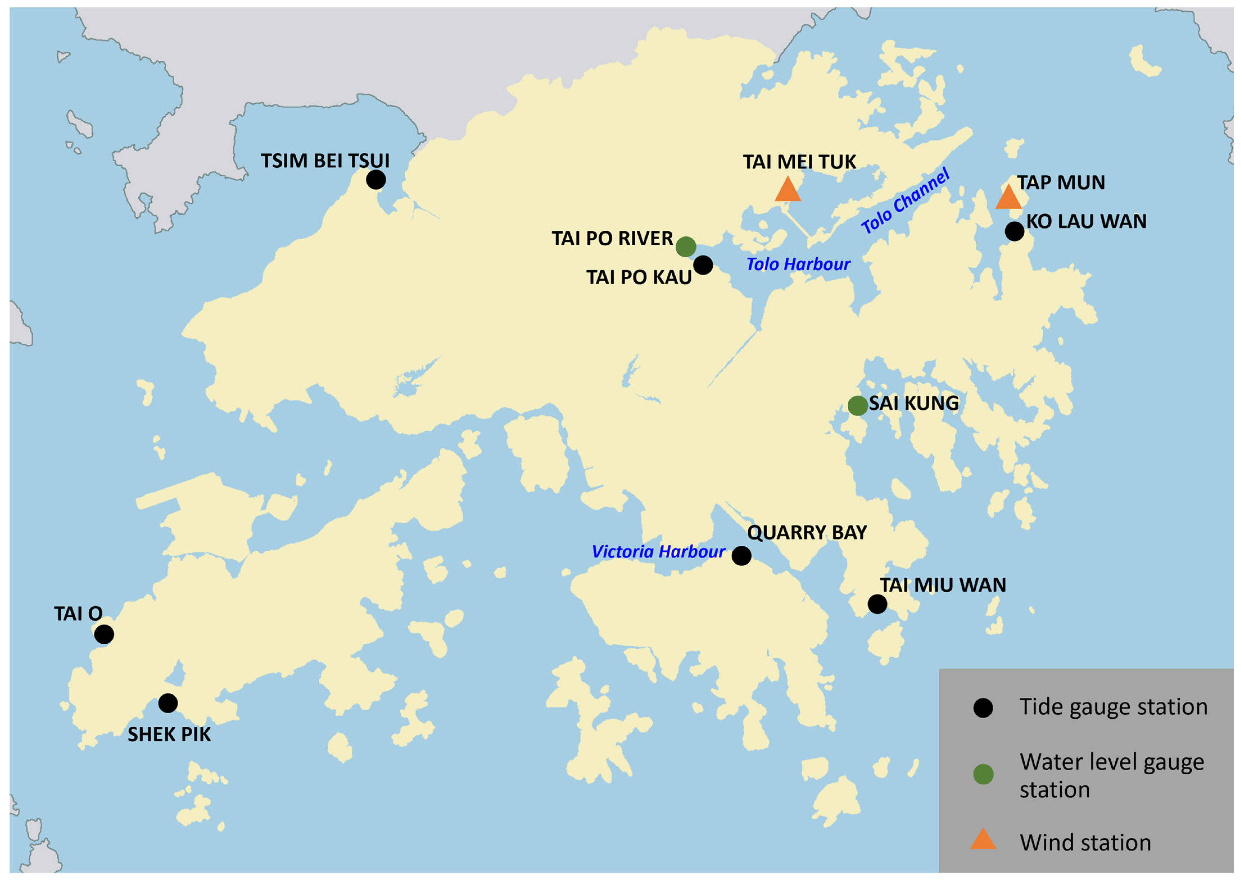
Figure 1 marks the location of selected tide gauges/water level gauges and wind stations in Hong Kong mentioned in this paper. The tide gauge station at Quarry Bay (QUB) has the longest sea level record. It is located in Victoria Harbour near the centre of Hong Kong, both sides of which are the most densely populated urban areas. The tide gauge station at Tai Po Kau (TPK) over the northeastern part of the territory has been monitoring the sea level inside Tolo Harbour, which is most susceptible to storm surges when strong northeasterly winds prevail over the region during the passage of TCs due to its funnel-shaped coastline. The tide gauge station at Tai O (TAO) over the southwestern part of Hong Kong is situated in the low-lying areas known for its traditional fishing village with stilt houses. Despite being one of the flood-prone areas in Hong Kong, the discussions in this study are primarily focused on the storm surge recorded at QUB and TPK.
The maximum storm surge induced by Super Typhoon Saola (2309) struck the city around the time of the lower high tide of the day, with the height of sea level at TPK inside Tolo Harbour reaching 3.32 mCD (metres above Chart Datum) with a storm surge height of 1.48 m. This storm surge record was ranked eleventh in Hong Kong following Super Typhoon Hato in 2017. The storm surge analysis of Hato can be found in Choy et al. [
8].
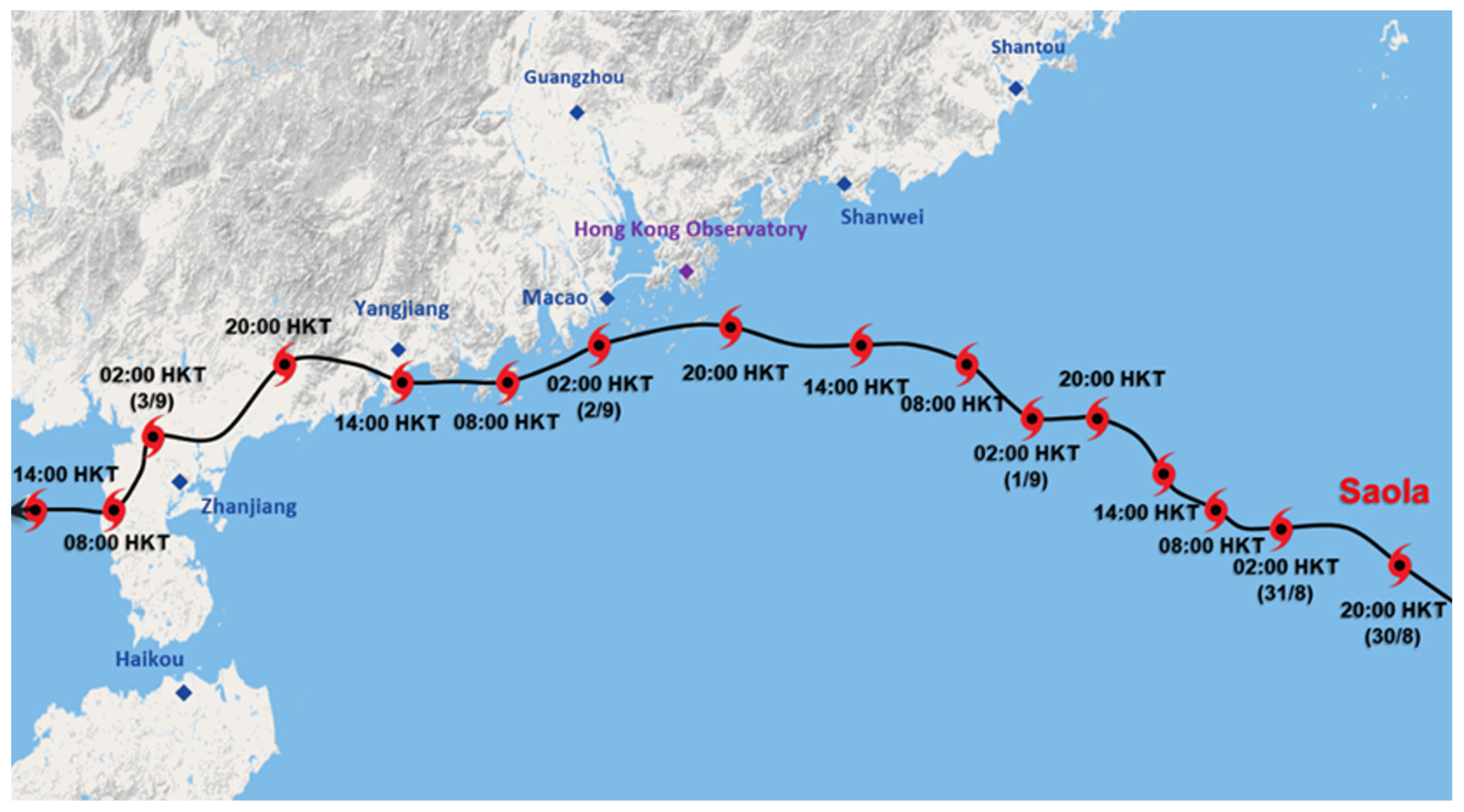
Saola formed over the seas east of Luzon on 24 August 2023. It lingered over the region for several days. Under favourable conditions of warm seawater and weak vertical wind shear, Saola intensified from a tropical storm into a super typhoon in just about 3 days. After Saola entered the northeastern part of the South China Sea as a super typhoon on 30 August, it was steered by the subtropical ridge and took on a west-northwestward track, gradually approaching the coast of Guangdong. Owing to favourable conditions over the northern part of the South China Sea, Saola remained intact with its compact circulation. With an estimated highest sustained wind speed at around 230 km/h near its centre, it was the second-strongest tropical cyclone in the South China Sea on record since 1950. Saola continued to move along the coast of Guangdong after it passed to the south-southeast of Hong Kong within 40 km from the HKO around midnight of 1 September (
Figure 2). It gradually weakened under the influence of the northeast monsoon. Super Typhoon Saola necessitated the issuance of Hurricane Signal No.10 in Hong Kong subsequent to Mangkhut in 2018 [
9]. An observational study of Saola had been made by Chan et al. [
10], including surface and upper air meteorological observations, and a review of the model performance and challenges of forecasting the track, intensity and wind structure of Saola had also been conducted [
11]. This is the third paper in the series about Saola which is focused on the aspect of forecasting storm surges and the challenges in the risk assessment of inundation.
The remaining parts of this paper are arranged as follows:
Section 2 summarises the storm surge brought by Saola to Hong Kong. The data and method used in storm surge forecasting in Hong Kong are given in
Section 3. The forecast performance based on the re-analysis of TC parameters and the considerations in the hindcast of storm surges are given in
Section 4.
Section 5 and
Section 6 respectively discuss the evaluation of the storm surge model and the possible risk of sea inundation.
Section 7 provides a nowcast workflow from the operational aspect aiming at producing accurate storm surge predictions for the next 6 to 12 h for cases similar to Saola. Some concluding remarks are highlighted in
Section 8.
2. Storm Surge Brought by Saola to Hong Kong
In addition to sea level rise due to the low pressure near Saola’s centre, easterly winds of the storm to hurricane force pushed sea water towards the coast and piled up water along the eastern coast of Hong Kong when Saola was located to the south of Hong Kong. Due to the coastal morphology of Tolo Harbour with the inlet of the east-northeast-oriented Tolo Channel (
Figure 1), storm surges could be significant when the prevailing wind direction is aligned with the orientation of the channel.
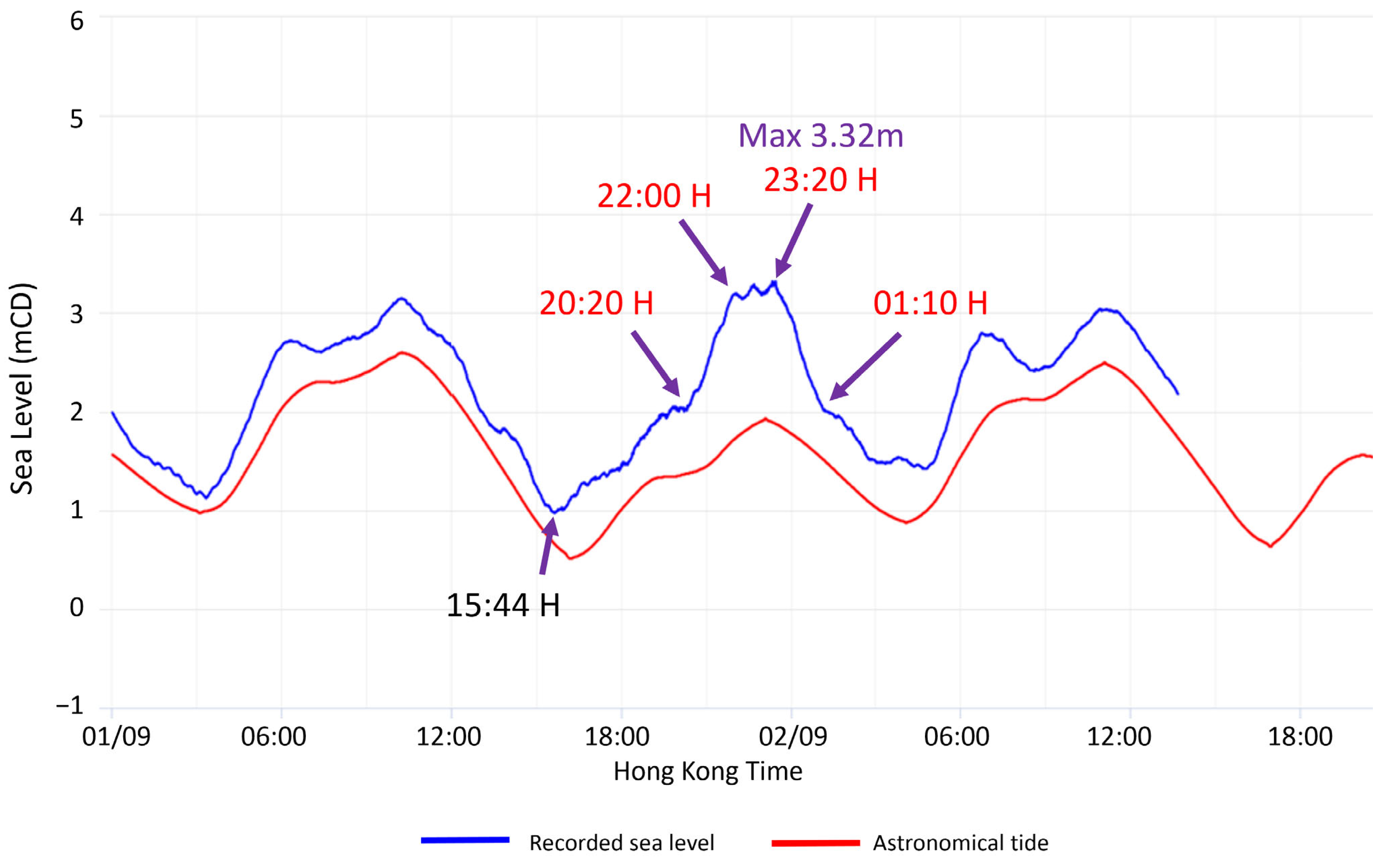
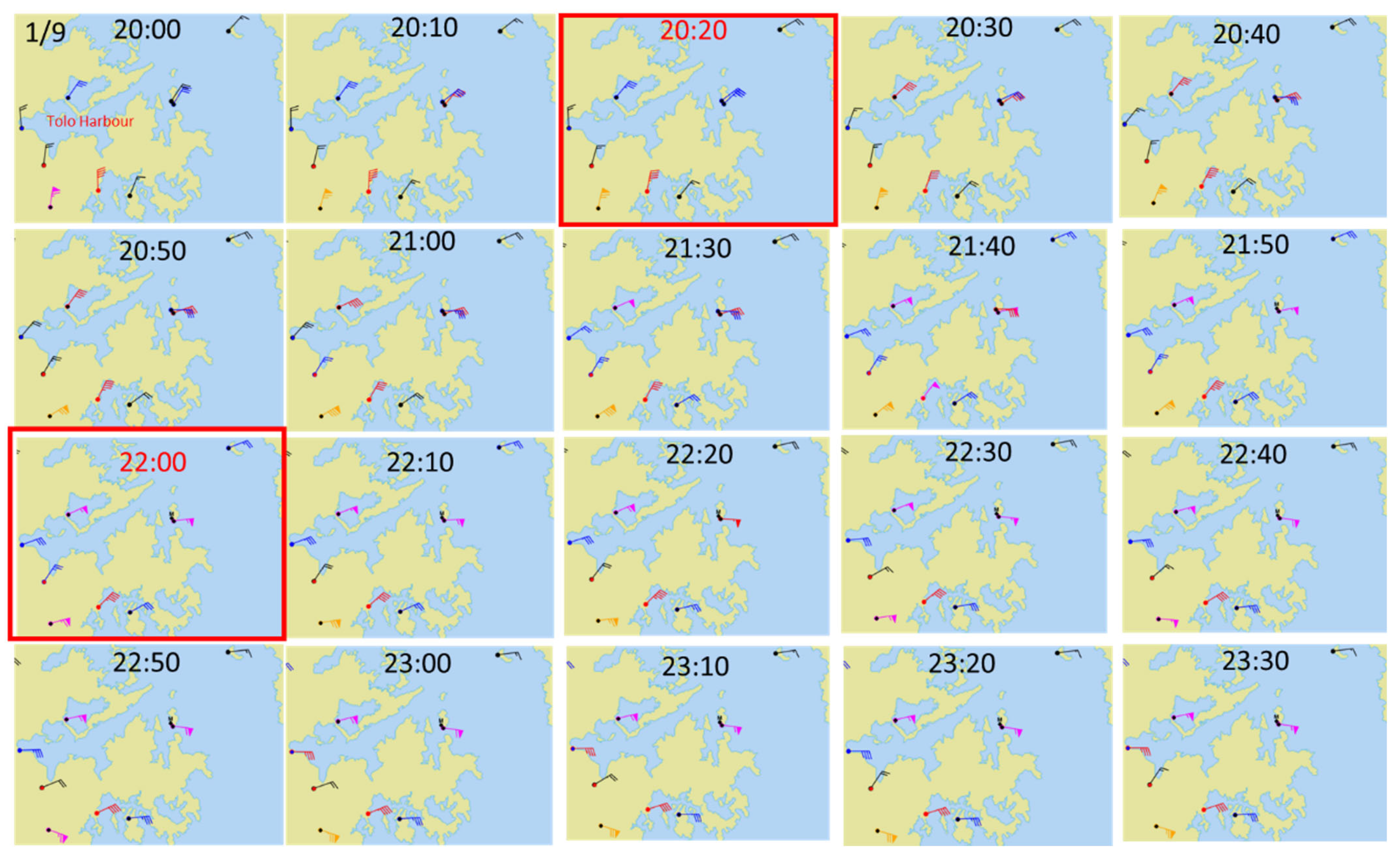
Figure 3 shows the sea level recorded at TPK inside Tolo Harbour. The water started to rise at 15:44 H on 1 September 2023. From 20:20 H to 22:00 H, the water level rose quickly as the wind direction changed from the northeast to east-northeast with increasing wind speed. The rising trend of water level was moderated at 22:00 H when the wind direction further veered to the east, which is less favourable to pushing water into Tolo Harbour. The maximum storm tide was marked at a height of 3.32 mCD at 23:20 H on 1 September. Afterwards, the water level dropped as Saola started to depart, and winds over the region weakened.
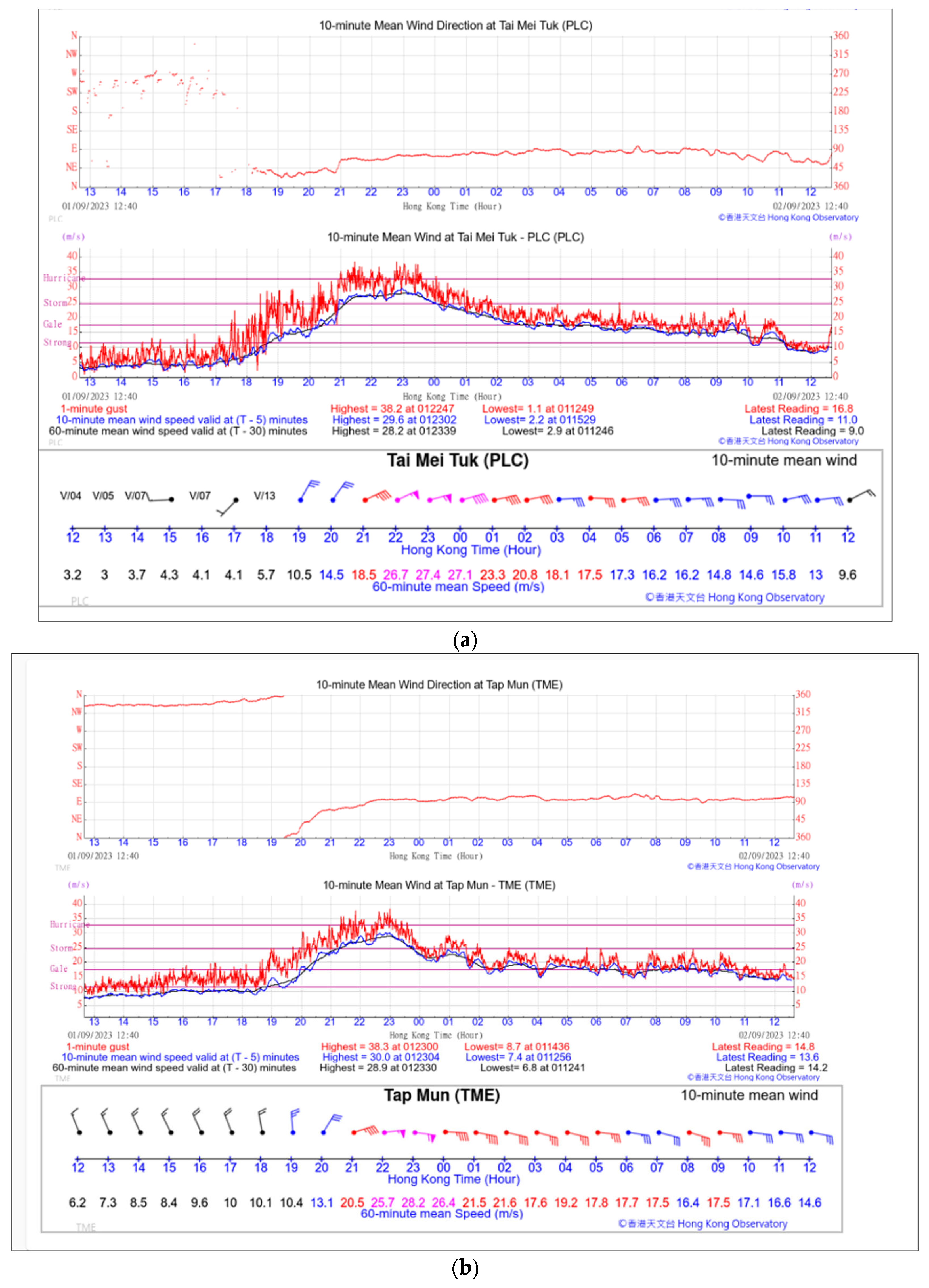
Figure 4a,b respectively show the wind speed and direction at Tai Mei Tuk and Tap Mun, both of which are located inside Tolo Harbour. A 10 min sustained mean wind of storm force with a maximum of 29.6 m/s (98 km/h) and 30.0 m/s (108 km/h) were, respectively, recorded at these two stations. No sustained hurricane-force winds (≥118 km/h) were registered in Tolo Harbour during the whole episode (
Figure 5).
As shown in
Figure 3, the astronomical lower high tide at TPK on 1 September occurred at 23:00 H. As the maximum of the storm surge coincided with the lower high tide at the eastern Hong Kong waters, the increase in water level over the region including Tolo Harbour was particularly high and the aggregated effect resulted in a sea inundation of some low-lying areas in Hong Kong. The water level at TPK, Tai Po River and Sai Kung reached a maximum of 3.32 mCD, 3.89 mCD and 4.52 mCD, respectively. At QUB, the maximum storm surge was 0.76 m and it did not coincide well with the lower high astronomical tide, resulting in a maximum storm tide of 2.58 mCD only at the closest approach during the night of 1 September, much less than that in Tolo Harbour.
Table 2 shows the recorded maximum storm surge and maximum storm tide at selected tide stations during the passage of Saola from 1 to 2 September 2023.
3. Data and Methods
Numerical modelling is adopted for real-time forecasting of storm surge in Hong Kong. Both deterministic and probabilistic forecasts are produced based on a parametric model with a circularly symmetric tropical cyclone wind profile which is defined by
where R is the storm size (i.e., the radius of maximum wind, RMW), r is the distance from the TC centre and V
max is the maximum wind speed. The model is named the Sea, Lake and Overland Surges from Hurricanes (SLOSH) model, developed by the National Oceanic and Atmospheric Administration (NOAA) of USA [
12]. SLOSH has been used by HKO to support storm surge forecast and alert service since 1994.
SLOSH is a 2D explicit, finite-difference model formulated on a semi-staggered Arakawa B-grid. The Navier–Stokes momentum equations for incompressible and turbulent flow are adopted as the horizontal transport equations and solved numerically. The dissipation in the model transport equations is solely determined by an eddy viscosity coefficient and a bottom slip coefficient is included. The governing equations are integrated over the entire depth of the water column. The horizontal transports are calculated from the pressure, Coriolis and frictional forces at every time step. These transports produce an update to the surge level at model grid points. Although the parametric wind model of SLOSH is relatively simple, it had been proven to be reasonably realistic and is an effective and efficient model to predict the storm surges over the northern Atlantic basin in a case study of Hurricane Sandy by Forbes et al. [
13]. For HKO’s setup, the model operates on a polar grid with a grid size ranging from 1 km near the centre around Hong Kong to about 7 km in the open sea.
A simple parametric wind model is embedded in SLOSH. The input meteorological data of SLOSH include TC positions (latitudes and longitudes of TC centre), central pressure deficit (background pressure minus central minimum pressure) and storm size, in 6-hourly intervals from 48 h before to 48 h after the time of closest approach to Hong Kong. Storm size is defined as the distance from the centre of a TC to the location of the maximum winds. In a well-developed TC, RMW is normally near the eyewall, and accordingly, the locations affected by the most serious storm surge would be near RMW of the TC. Given the storm size and central pressure deficit, SLOSH will numerically solve a balanced flow equation to obtain the wind vector field relative to the storm centre. Including the storm movement, the wind-driven forcing is incorporated into SLOSH as wind stress. Previously, the central pressure deficit has been calculated by subtracting the analysed central minimum pressure of the TC from the climatological monthly mean sea-level pressure (MSLP) in Hong Kong, neglecting the change in the synoptic background pressure. In the current HKO’s operation, the analysed MSLP of the outermost isobar of the TC is taken as the synoptic background pressure at the initial time, while changes in the synoptic environmental pressure for future hours are derived from the NWP model forecast and are taken into account when calculating the central pressure deficit for T+48 h forecast in SLOSH. Gale wind (34 kt) radius (R34) is analysed by weather forecaster using various observation platforms. An automated algorithm to derive R34 and RMW from ECMWF model analysis of 10 m wind field has also been developed to provide objective guidance to forecasters. All available data and information are used to estimate 6-hourly TC positions, central maximum 10 min sustained wind, central minimum pressure and R34 in best-track analysis after the TC episode.
Bathymetric data from the publicly available General Bathymetric Chart of the Oceans (GEBCO) [
14] at 15-arc-second (~0.4 km) resolution and the restricted Electronic Navigational Chart of the Marine Department in Hong Kong at 30 m resolution are used to prepare the basin files for running SLOSH. The SLOSH output of storm surge is added to the astronomical tide prediction from harmonic analysis at selected locations in Hong Kong to obtain the prediction of storm tide (the total sea level), which is compared with the sea level observations at tide gauge stations and water level gauges in model verification.
To address forecast uncertainties, a probabilistic approach could be used to quantify and assess the potential risk of storm surge [
15]. In recent years, HKO has developed the Probabilistic Inundation Map Evaluation System (PRIMES) to assess the risk of storm surge. Hypothetical tracks are generated based on the HKO’s TC warning track at the time and the statistics of cross-track (CTE), along-track (ATE) and central minimum pressure errors (PE) of the HKO’s past warning tracks. It is assumed that these errors follow a normal distribution. CTE could be considered the error in a direction deviating from the best track while ATE could be considered an error in the translation speed. The dataset of historical error of TC track is based on the period of 2016–2020 with forecast lead times from 0 to 120 h at 6-hourly intervals (
Table 3). The CTE, ATE and PE are fitted to a Gaussian distribution and then divided into 17, 7 and 3 equal bins, respectively. For PE distributions, the three equal bins represent three different perturbed intensities for stronger, weaker or no change in intensity in the prediction. As such, a total of 357 hypothetical tracks (17 × 7 × 3) of the storm is generated. Moreover, storm size, which is defined as the RMW, is one of the important parameters in storm surge prediction. However, this parameter is not available in the historical tracks or statistical errors. Therefore, results with four constant pre-defined storm sizes (small: 28 km; medium: 56 km; large: 84 km; extra-large: 112 km) are also generated in addition to the operational storm size in the distribution.
In this study, the 6-hourly positions and central minimum pressure of Saola taken from the provisional best track of HKO from 30 August to 3 September 2023 are tabulated in
Table 4. As the closest approach of Saola to Hong Kong was at 15 UTC on 1 September, the analysed storm information at 03, 09, 15 and 21 UTC is used as SLOSH input so the closest approach is more accurately represented instead of interpolated. The storm size of Saola is determined with reference to several analysis tools, including (i) Doppler wind analysis; (ii) multiplatform TC surface wind analysis; (iii) microwave imageries; and (iv) inference from best-track gale radius (34 kt wind radius, R34) through the parametric wind profile defined in SLOSH.
4. Estimation of Model Input Parameters
Super Typhoon Saola was very compact. When Saola was still far away from Hong Kong where surface observations were sparse, the storm size was estimated by measuring the distance from the centre to the inner eye wall where the winds associated with the storm should be the strongest. Multiplatform TC Surface Wind Analysis (MTCSWA) of NOAA [
16], microwave imageries such as Automated Rotational Center Hurricane Eye Retrieval (ARCHER) [
17], and Advanced Scatterometer (ASCAT) winds [
18] were also taken as reference.
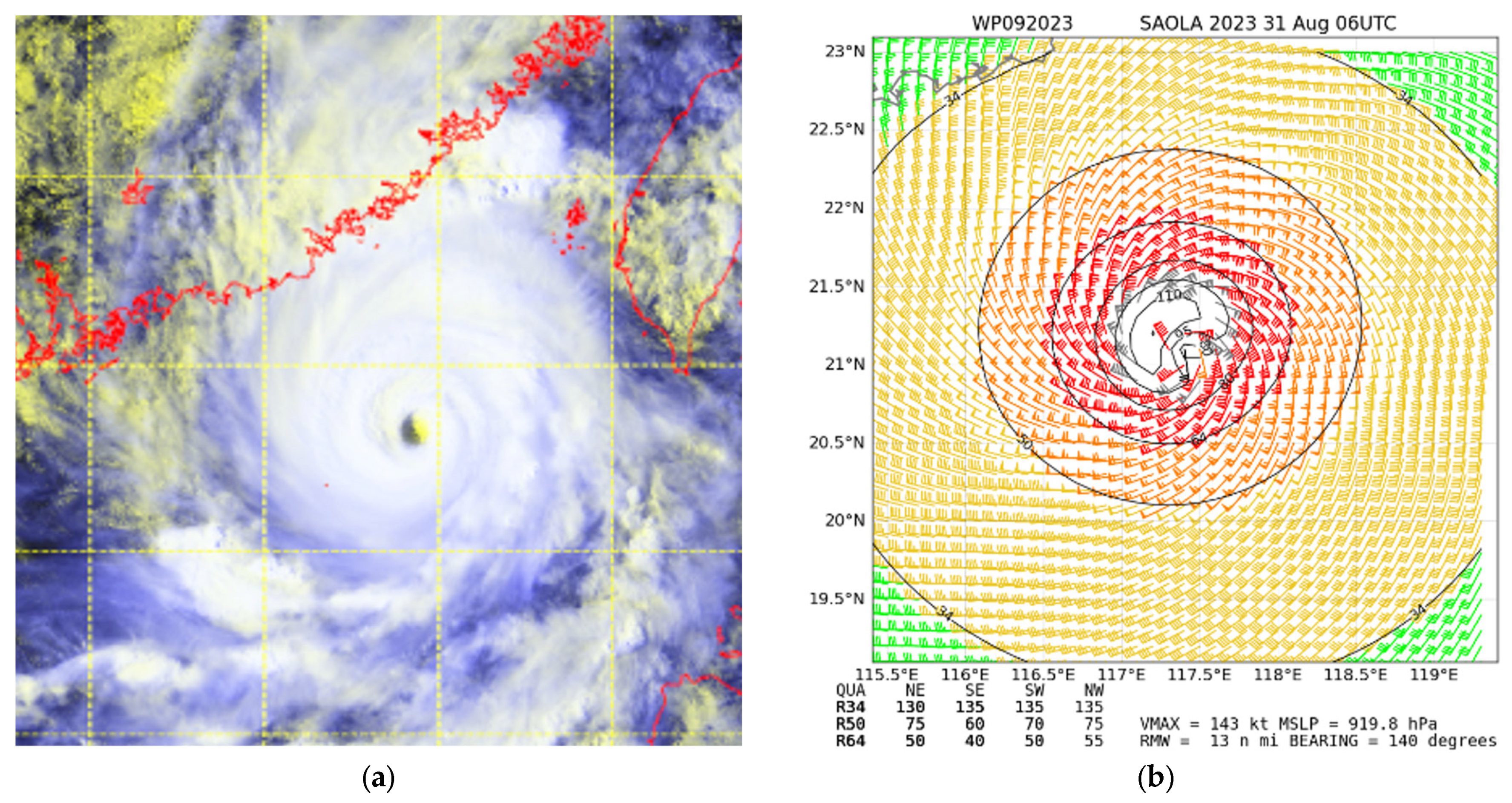
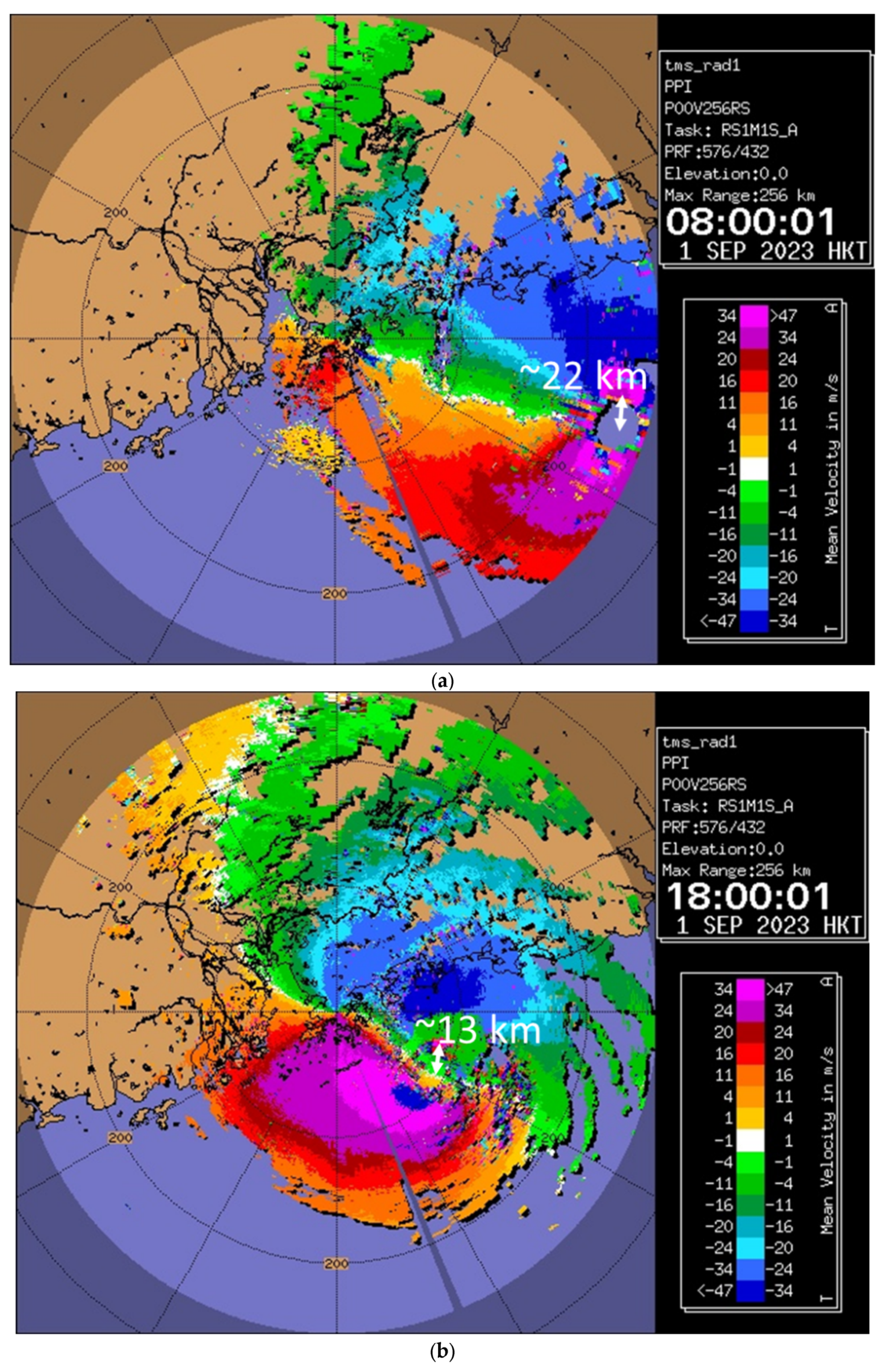
Figure 6 shows the satellite imagery and the MTCSWA at 06 UTC on 31 August 2023. The RMW estimated from these imageries was about 24 km. When Saola moved within the surveillance range of the HKO’s radarscopes starting from around 08:00 H (00 UTC) on 1 September, the storm size could then be estimated more accurately by analysing the Doppler velocity in addition to other supporting tools. More updated information about its location and estimated central minimum pressure could also be obtained. Based on all available tools and observations, more frequent updates of storm surge prediction could then be performed.
Figure 7a,b show the Doppler velocity field, respectively, at 08:00 H and 18:00 H (00 and 10 UTC) on 1 September. The storm size was estimated to be about 22 km at 08:00 H and was found to have reduced to about 13 km at 18:00 H. It is also apparent that the area of highest winds (negative radial velocity folded into positive, coloured in magenta, as indicated in
Figure 7) to the north of the TC centre shrunk. At 20:00 H (12 UTC), Saola further weakened with only a small area of high wind, the structure over the eastern side of Saola became less intact and the high-wind area to its southwest quadrant was also reduced. By analysing the storm size using different methods, the estimated storm size data used as input to SLOSH hindcast are listed in
Table 4.
5. Evaluation of Storm Surge Forecast Based on Re-Analysed TC Parameters
Based on the provisional best-track analysis of Saola in
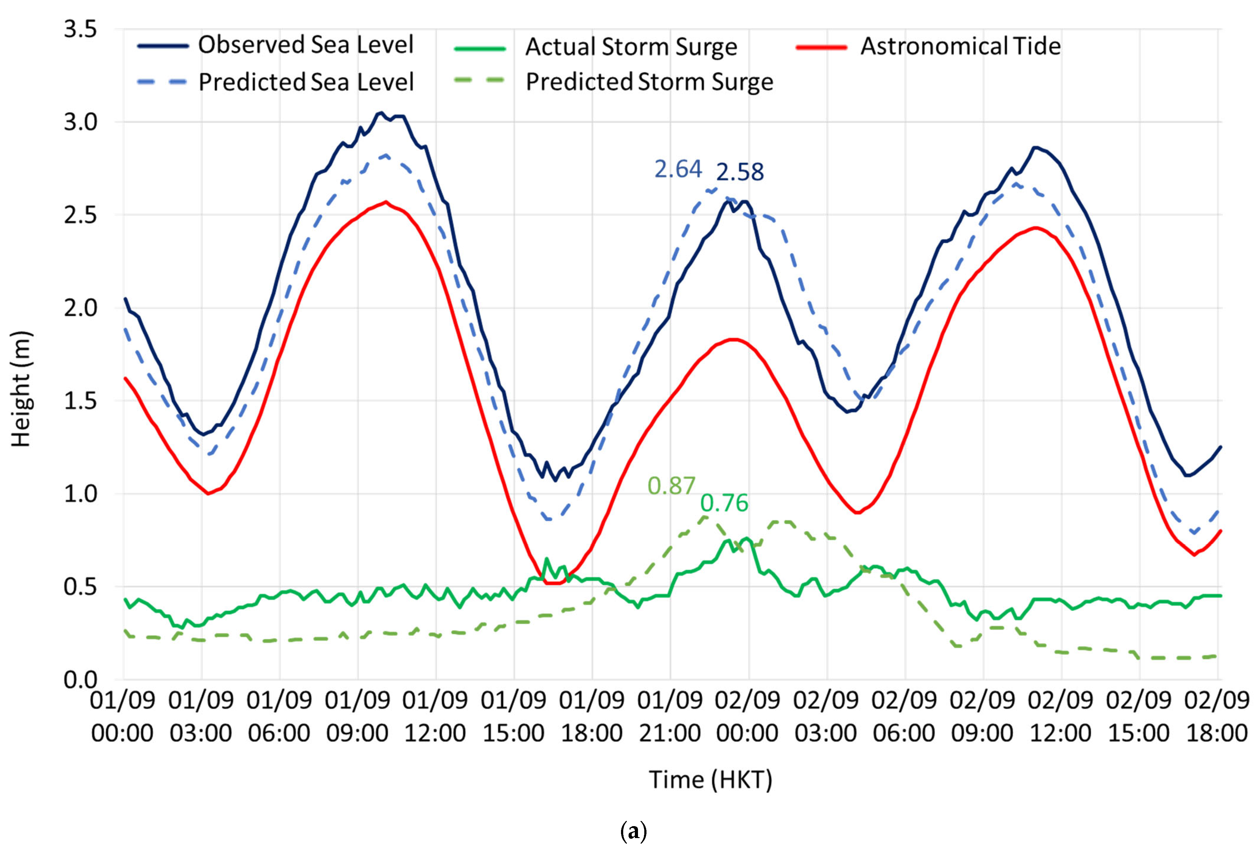
Table 4, the predicted maximum storm surge at QUB occurred around two hours earlier than the observed maximum storm surge, and the predicted maximum storm tide was 2.64 mCD, in good agreement with the observed 2.58 mCD near midnight of 1 September 2023 when Saola was around its closest approach to Hong Kong (
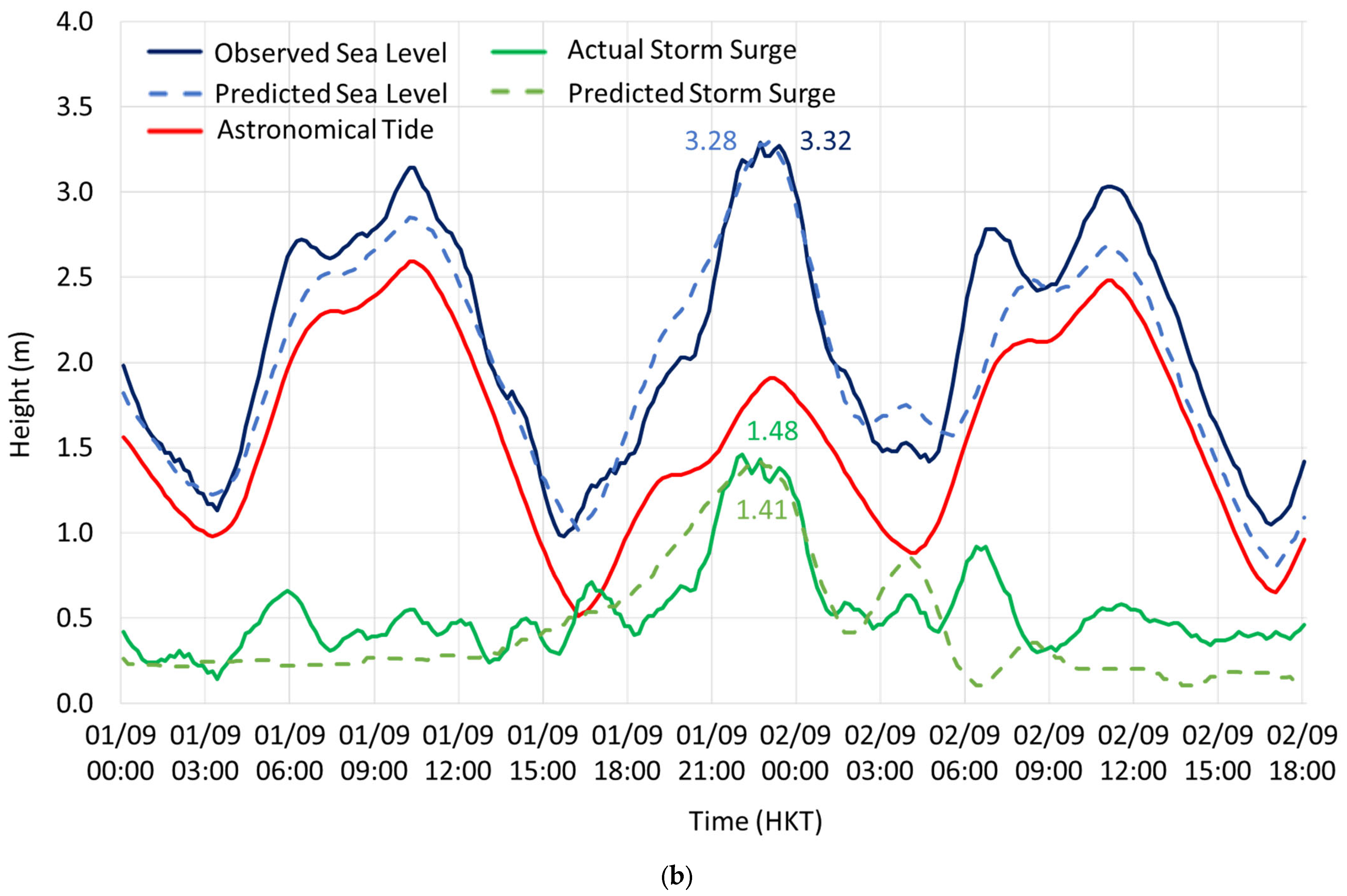
Figure 8a). At TPK, the predicted maximum storm surge was in good agreement with the observed maximum storm surge and basically coincided with the occurrence of the astronomical lower high tide of the day. The predicted maximum storm tide of 3.28 mCD also agreed very well with the observed 3.32 mCD. The time series of the predicted storm surge and storm tide at QUB and TPK are given in
Figure 8. A comparison of the predicted and the observed maximum storm surge and storm tide at QUB, TPK and TAO is listed in
Table 5. The predictions generally agreed well with the observed values, demonstrating that SLOSH should be able to predict reasonably well the storm surge impact to Hong Kong brought about by Saola.
The under-estimation of the predicted sea level of the order of 0.2–0.3 m as compared with the observed sea level on the day before and after the closest approach of Saola was believed to be due to the fact that the parametric storm surge model SLOSH only takes into account the effect of the storm without accounting for the effect of geostrophic tilt due to alongshore currents driven by the strong alongshore wind stress associated with the northeast monsoon over the coast of southeastern China in the synoptic background. The effect of the northeast monsoon dominated more than the effect of storm surges induced by Saola before and after the day of the closest approach.
6. Assessment of Storm Surge Risk in Hong Kong
6.1. Sensitivity Test of TC Parameters
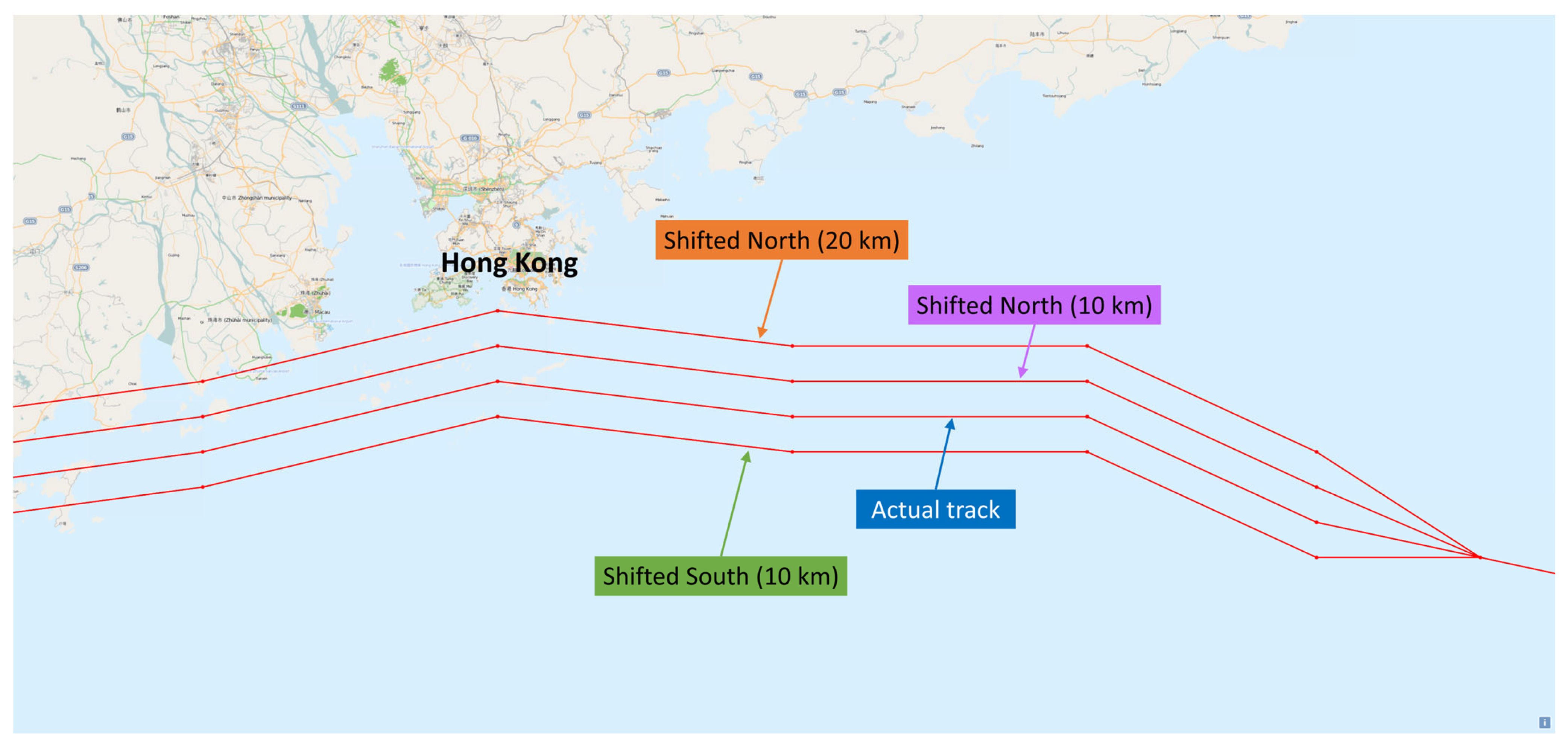
To evaluate the uncertainty in the prediction of storm surges, sensitivity tests were conducted to assess the potential storm surge risk associated with Saola. One of the sources of uncertainty in the storm surge forecast is the distance of closest approach to Hong Kong. It was found that if the forecast track was shifted northwards (i.e., closer to Hong Kong) by 10 km and 20 km (
Figure 9), the sea level at TPK would be around 11% and 27% higher, respectively. On the other hand, if the forecast track of Saola was shifted southwards (i.e., farther away from Hong Kong) by 10 km, the sea level would be about 8% lower at TPK. It was also noticed from
Table 6 that the water level at TPK was more sensitive than that at QUB in the sensitivity test. The rate of change of water level at TPK and QUB as a function of the distance of closest approach was found to be about 4 cm/km and 1 cm/km, respectively, when the TC tracks were within about 40 km south of Hong Kong, similar to the findings in the study of Super Typhoon Hato (2017) in Choy et al. [
9].
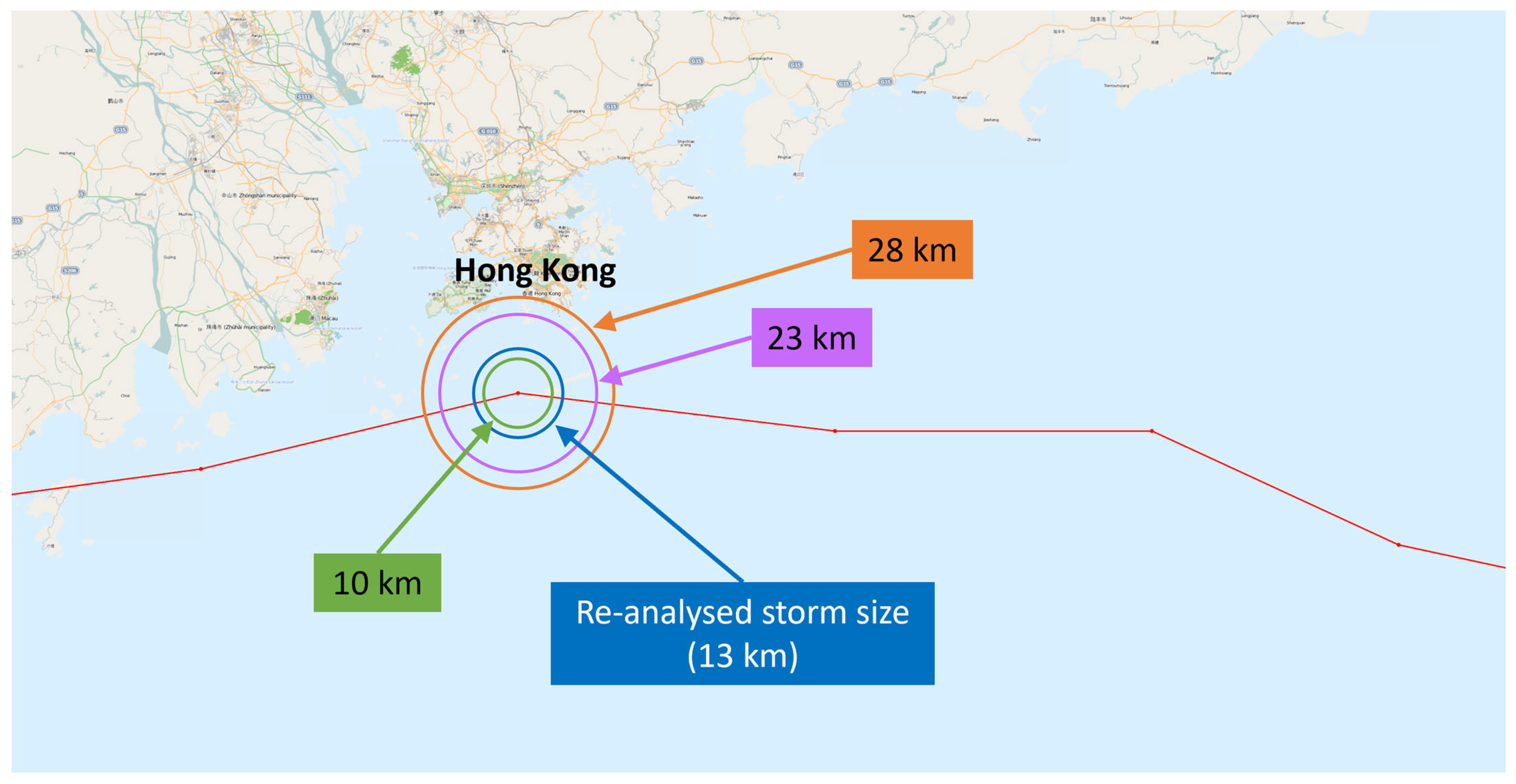
Another source of uncertainty in the storm surge forecast originates from the storm size. The setting of storm size in the sensitivity test and its relative distance from Hong Kong can be seen in
Figure 10.
Table 7 shows the sensitivity test results of storm size on the impact of storm tide at QUB, TPK and TAO. If the storm size was slightly larger than the re-analysed storm size by 10 km (i.e., 23 km), the water level at TPK would be about 30% higher given the same TC intensity. If the storm remained at a size of 28 km as at 36 h before its closest approach, the water level at TPK would be around 45% higher.
Sensitivity tests were also conducted by adjusting the central minimum pressure of Saola by 4 hPa upwards and downwards during its closest approach to Hong Kong. The difference in storm tide was only about 1% at QUB and 2% at TPK. It is not very sensitive to the change in central minimum pressure as compared with the storm size parameter.
Judging from the results of the sensitivity tests, it is evident that sea level is very sensitive to storm size when the TC is close to Hong Kong, especially passing to the south. In the parametric storm model of SLOSH, storm size and the distance of closest approach will affect the duration, strength and direction of high winds, which will in turn affect the storm surge especially in areas with local effects such as the bay area. Even only a small change of 10 km in RMW or with the TC edging closer to Hong Kong by merely 10 km could result in substantially different storm surge levels. Furthermore, the sensitivity test also indicated that the storm tide prediction with respect to the storm size was more sensitive at TPK as compared with QUB, with a rate of water level increase of 11 cm at TPK and a 6 cm increase at QUB for each kilometre increase in RMW given the same TC intensity in the Saola case.
An accurate storm size estimation and TC position forecast near the time of closest approach are hence crucial for storm surge prediction. This is particularly critical when the storm tide forecast is close to the threshold of the storm surge alert, and more importantly when determining whether it will be higher than the coastal structures such as the sea wall or flood gate at certain low-lying regions that may trigger the need for evacuation as an emergency response measure.
6.2. Probabilistic Forecast of Storm Surge
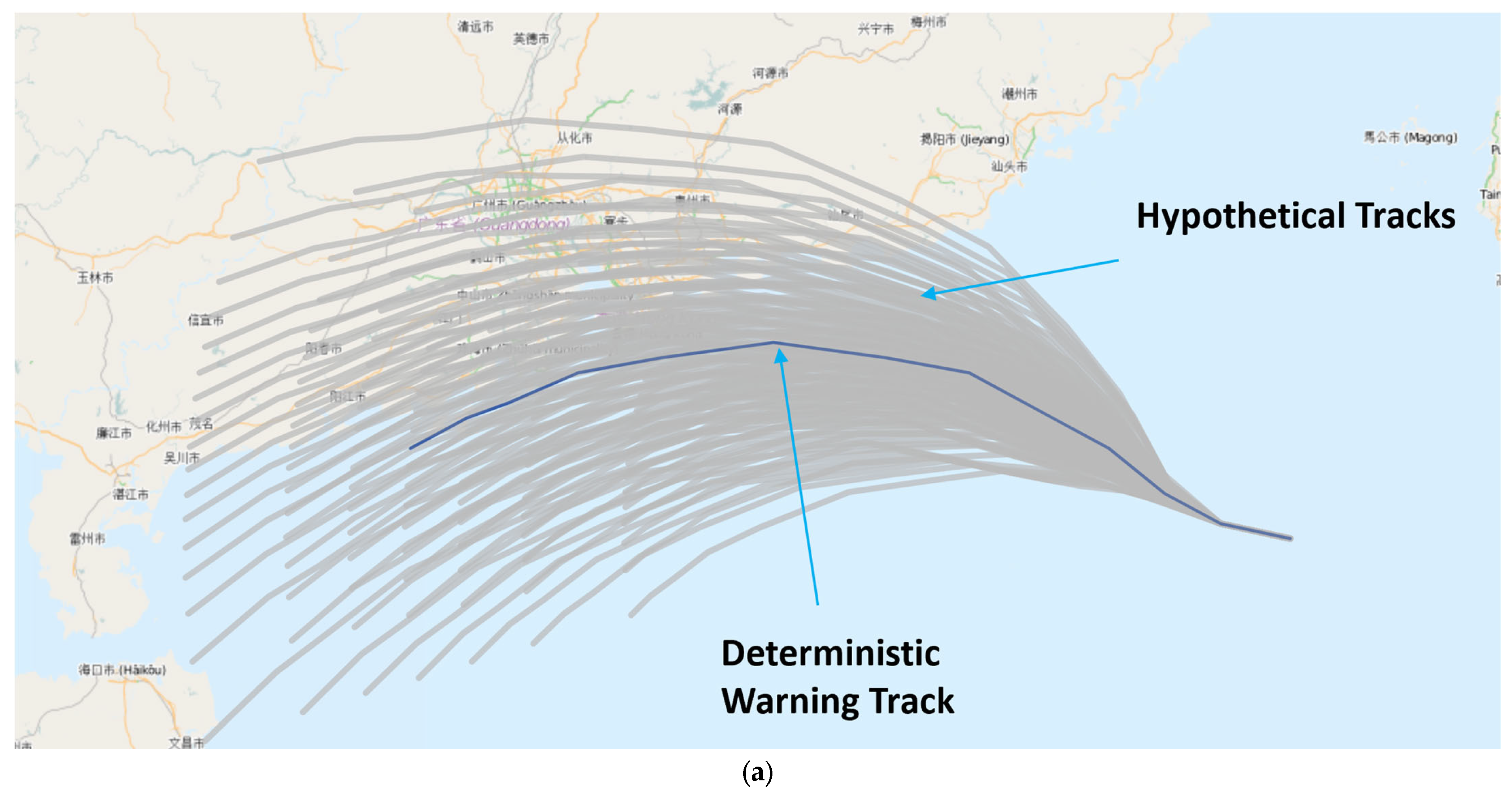
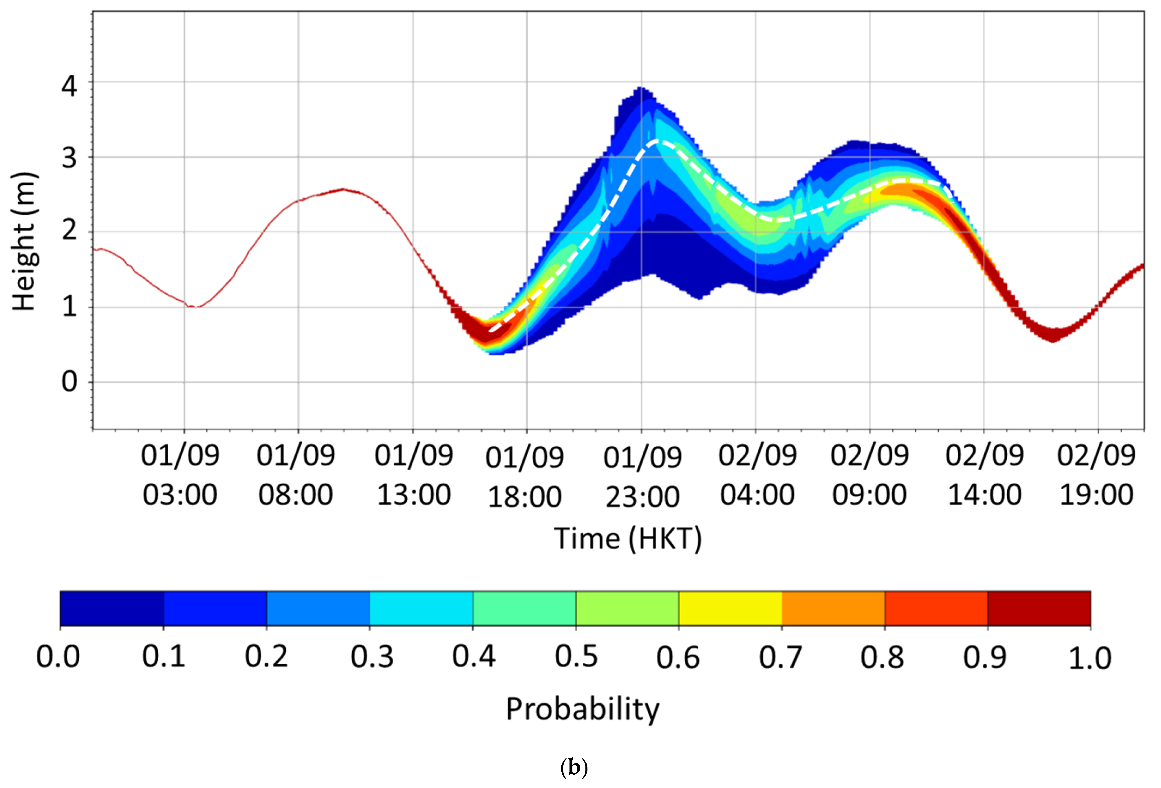
Figure 11 shows the forecast tracks from PRIMES with a model initial time at 06 UTC on 31 August and 1 September 2023, around 33 h and 9 h, respectively, before the closest approach of Saola to Hong Kong. These hypothetical tracks were input to the HKO’s operational storm surge model SLOSH to compute an ensemble of storm surge predictions, from which PRIMES outputs the probabilities of sea levels at different locations of Hong Kong and the corresponding risk assessment products such as probability time series and inundation maps, in support of storm surge operation.
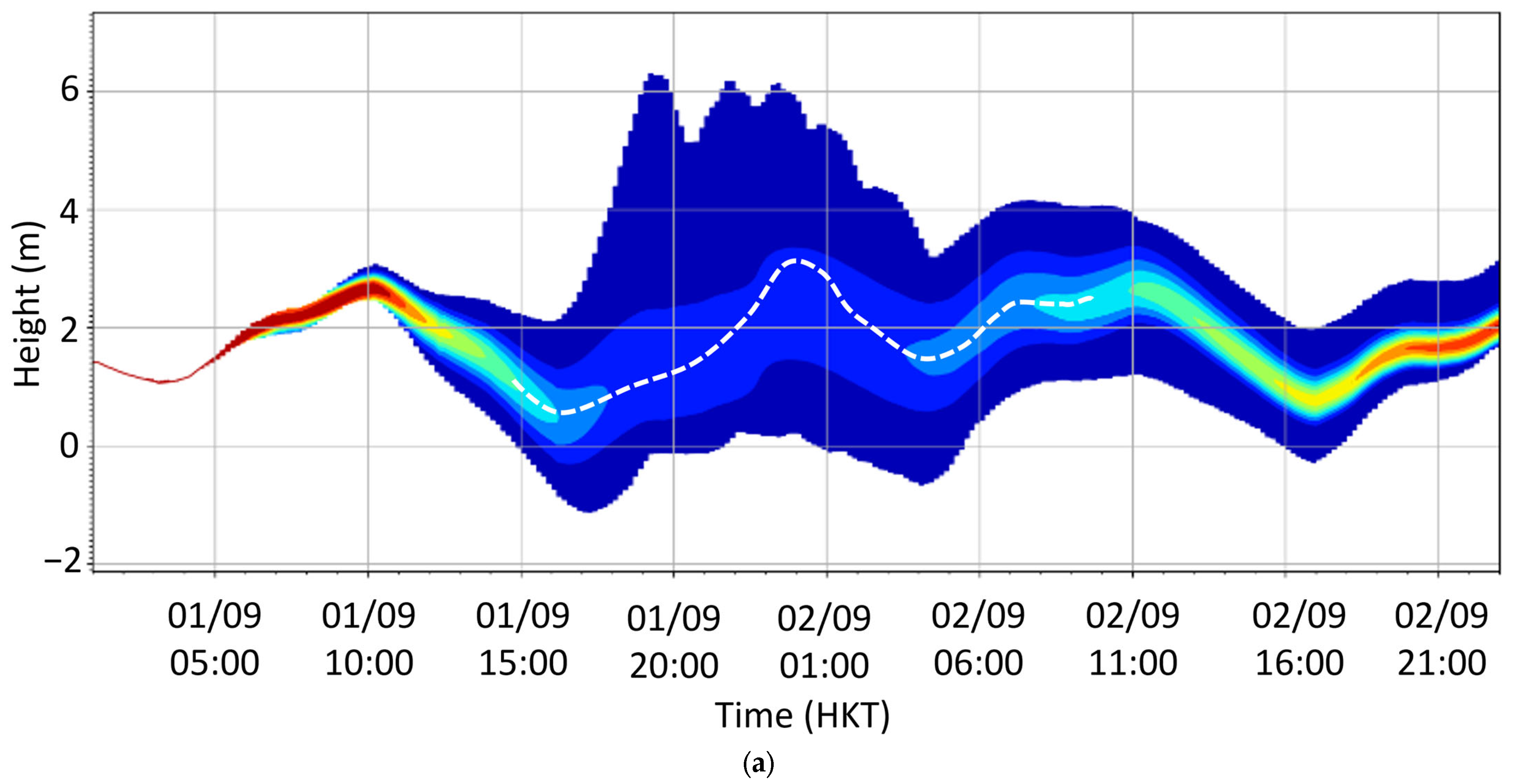
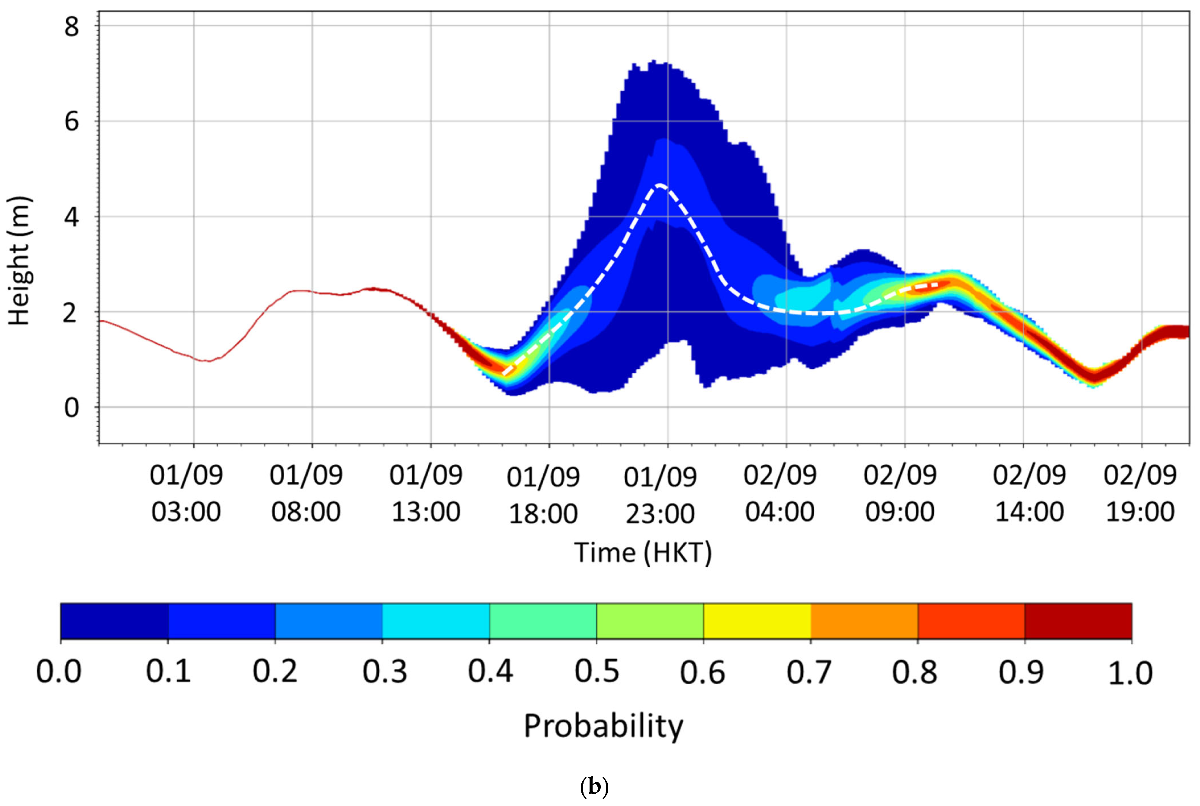
Figure 12 and
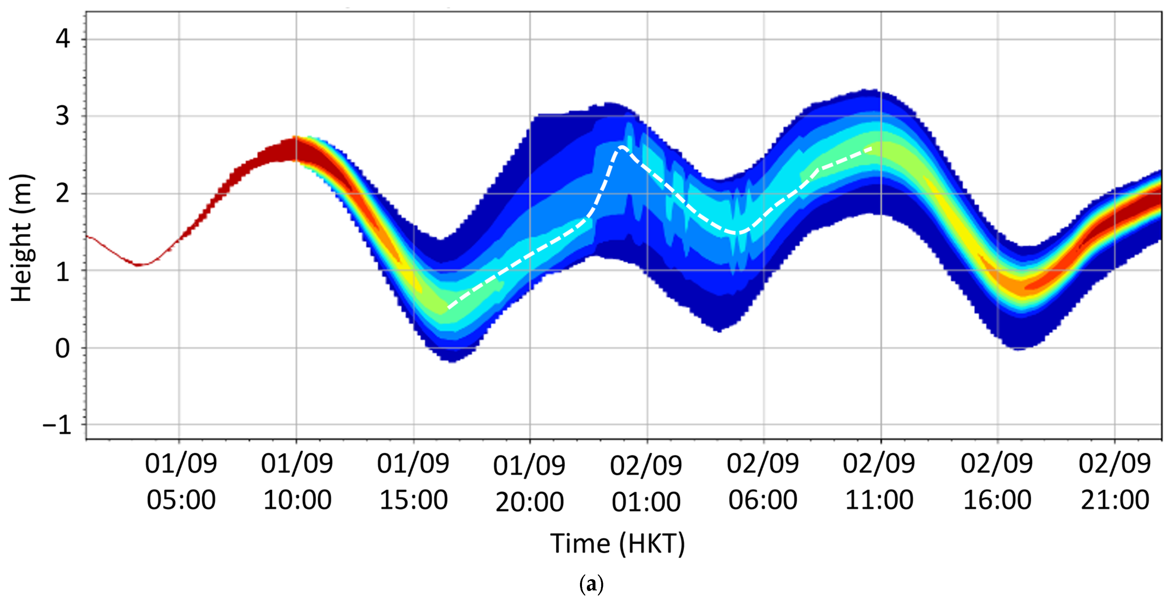
Figure 13 show the probabilistic plume map for the storm tide forecast at TPK and QUB corresponding to the PRIMES forecast tracks and intensities in
Figure 11a and 11b, respectively. The white dashed line in each panel shows the most probable storm tide height. The results indicated that the highest possible sea level reached the order of 6 mCD at TPK, and the spread in the timing of the high water level was large, ranging from 18 H on 1 September to 01H on 2 September based on the run at 06 UTC on 31 August. The result also suggested that the certainty was higher for an expected sea level of around 3.0 mCD near the closest approach (the peak of the white dashed line in
Figure 12a). The spread in the timing of the highest storm tide decreased with a higher certainty due to the reduced lead time based on the later run at 06 UTC on 1 September (
Figure 12b). However, with the higher TC intensity forecast of Saola in HKO’s TC Warning for Shipping on that day (1 September), the probability was higher for a sea level over 4 mCD. Similarly, for QUB, there was a small probability of a sea level slightly over 3 mCD, and the forecast timing of high water levels was spread over four hours from 20:00 H on 1 September to 00:00 H on 2 September. There was a higher certainty in the expected sea level of around 2.6 mCD near the closest approach (the peak of the white dashed line in
Figure 13a). The spread of the forecast timing of the high water level reduced in the PRIMES output based on the HKO’s TC warning for shipping at 06 UTC on 1 September, while the probability of a sea level over 3.0 mCD was higher (
Figure 13b), again due to the higher TC intensity forecast on that day.
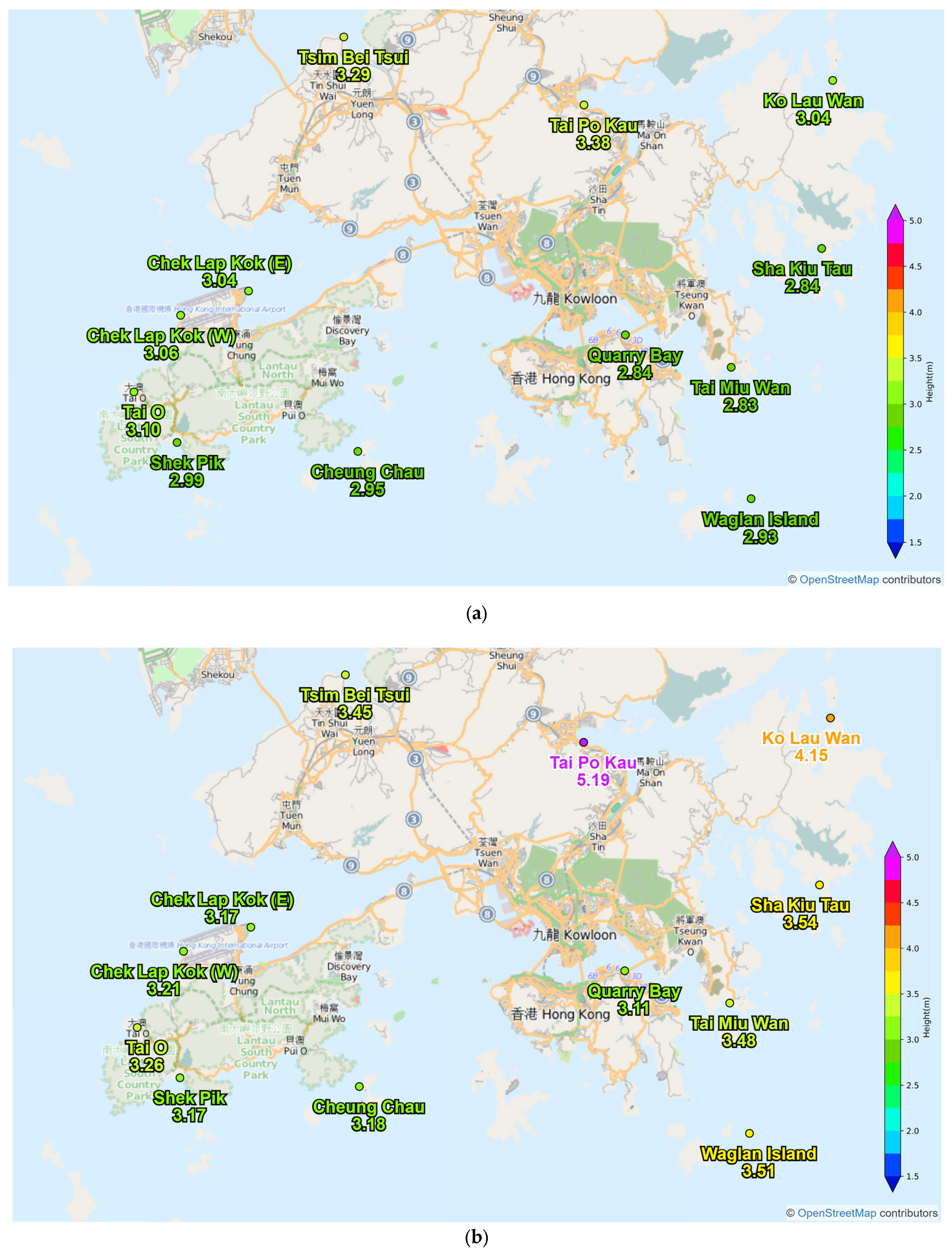
Based on the PRIMES output using the statistical perturbation method, 50% and 90% exceedance height maps were produced to facilitate the risk assessment of sea inundation. The percentage of exceedance height means the probability of the maximum storm tide exceeding such height. A higher percentage implies a lower exceedance height. The 50% exceedance height map for the PRIMES output at 06 UTC on 31 August indicated that the maximum storm tide would be 3.38 mCD at TPK and 2.84 mCD at QUB (
Figure 14a). In fact, with a more accurate TC intensity forecast, the 50% exceedance height forecasts of this earlier PRIMES run were generally in better agreement with the observed maximum (3.32 mCD at TPK and 2.58 mCD at QUB), as compared with the later run at 06 UTC on 1 September when higher intensities were adopted (5.19 mCD at TPK and 3.11 mCD at QUB (
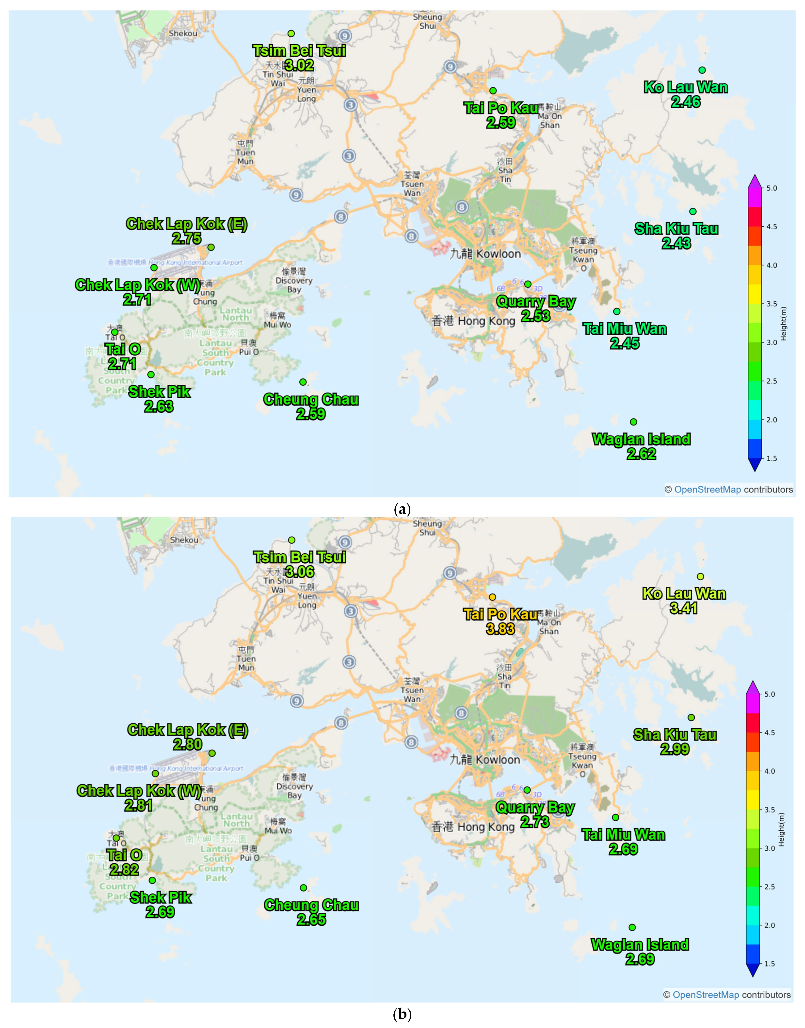
Figure 14b)). From 90% exceedance height maps in
Figure 15, the maximum storm tide was 2.60 mCD/3.83 mCD at TPK and 2.53 mCD/2.73 mCD at QUB based on PRIMES outputs at 06 UTC on 31 August/1 September, from which the later run was found to be in better agreement when compared to the earlier run. It seems that when making a risk assessment of sea inundation due to the storm tide, more weighting could be put to a 50% exceedance height for longer lead times, while the exceedance height of higher percentages could be considered afterwards closer to the time of closest approach as forecast accuracy usually improves when the lead time decreases. However, it should also be noted that the probability of occurrence of high-impact extreme events is usually on the low side. Therefore, one should still be cautious while using a high-probability exceedance height as an alert/warning level, and the low-probability exceedance heights should not be completely ignored.
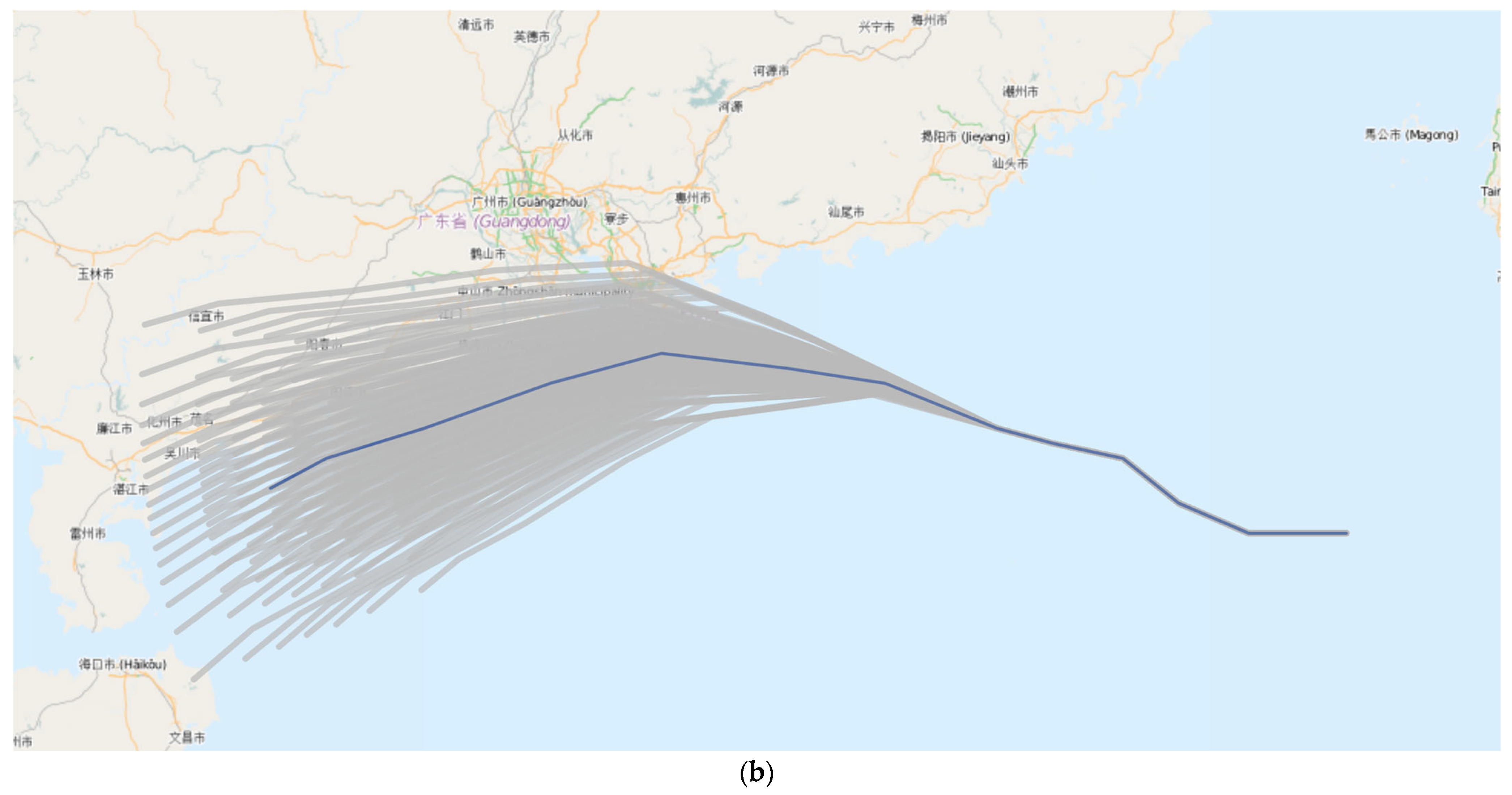
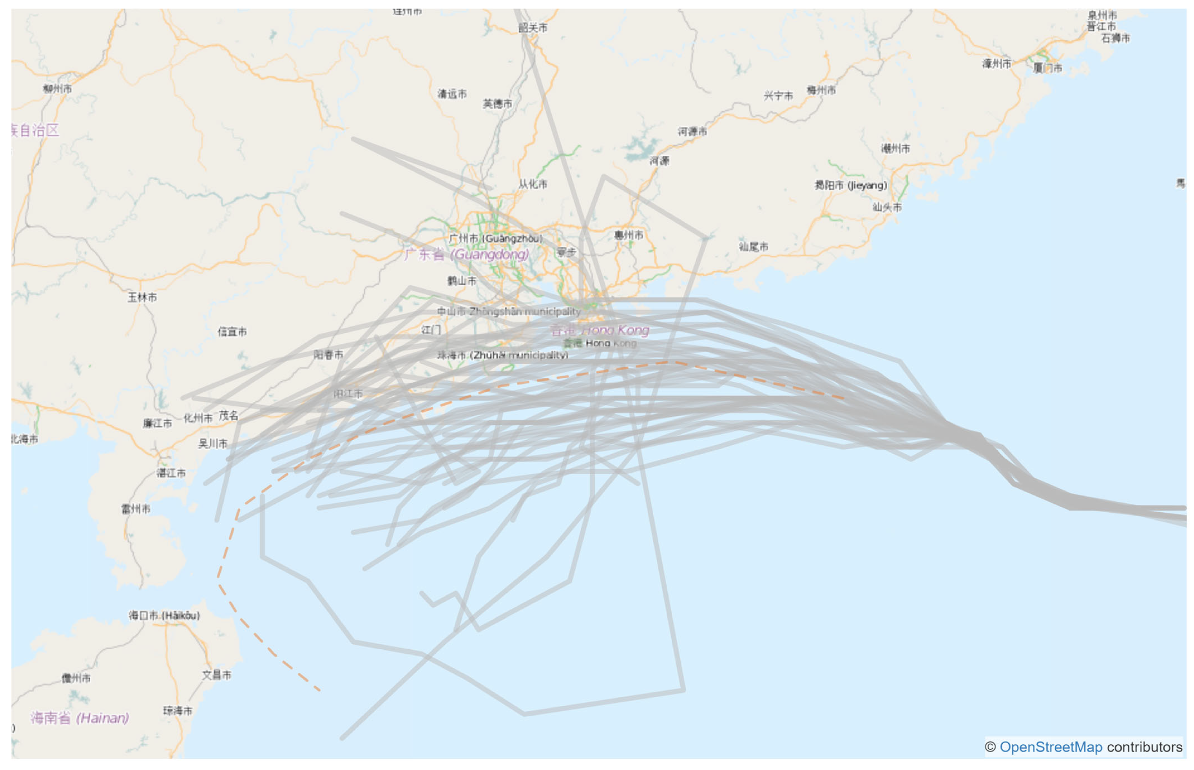
In addition to the statistical method, a dynamical method is also used to generate a probabilistic forecast of storm surges based on the TC forecasts from the European Centre for Medium-Range Weather Forecasts (ECMWF) Ensemble Prediction System (EPS) with 51 members at a high model resolution of 9 km. Global ensembles could be fit into finer-scale regional ensembles to facilitate reliable risk assessments based on objective model outputs [
19]. The EPS member tracks (
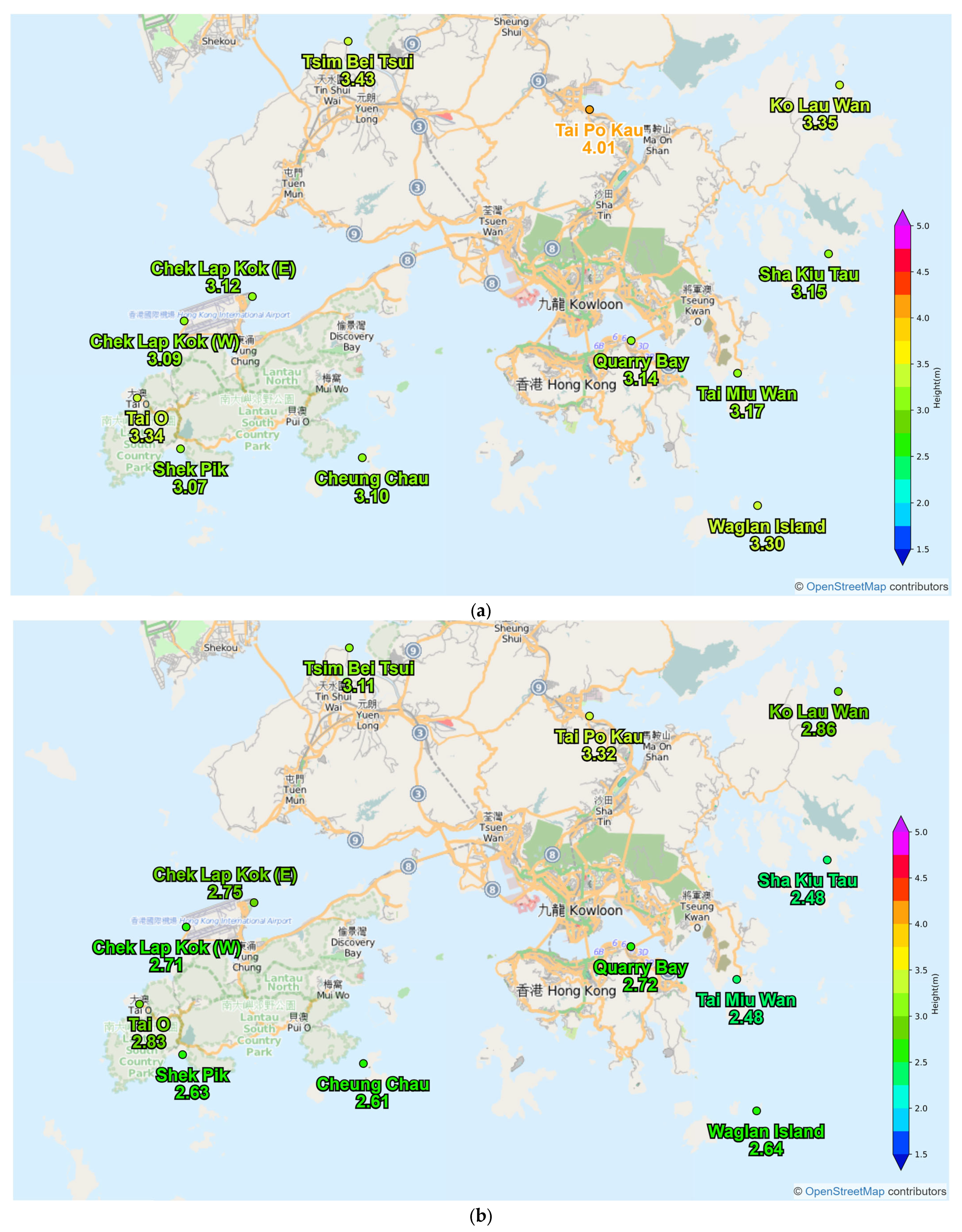
Figure 16) were input into the SLOSH model for producing a storm surge probabilistic forecast. Based on the model run initialised at 12 UTC on 31 August 2023, the 50% exceedance height map indicated that the maximum sea level at TPK and QUB could reach 4.01 mCD and 3.14 mCD, respectively, while the 90% exceedance height map hinted at a maximum of 3.32 mCD at TPK and a maximum of 2.72 mCD at QUB (
Figure 17), which were closer to the actual observations.
PRIMES played a crucial role in predicting storm surge probabilities in Hong Kong during the Saola’s episode. The statistical method in PRIMES showed an overall picture of the sensitivity of the storm surge level to various storm parameters, while the dynamical method showed alternative scenarios suggested by the predictions from the ECMWF EPS which are dynamically consistent in each member. By combining the use and interpretation of the results from both methods, weather forecasters can obtain useful information for assessing the situation in a more comprehensive manner. This integration of statistical and dynamical approaches of PRIMES forms part of the nowcasting workflow as shown in
Section 7. Furthermore, the use of a computationally efficient model like SLOSH is necessary for adopting the probabilistic approach in order to ensure the timeliness of the storm surge forecast.
7. Workflow of Storm Surge Nowcast
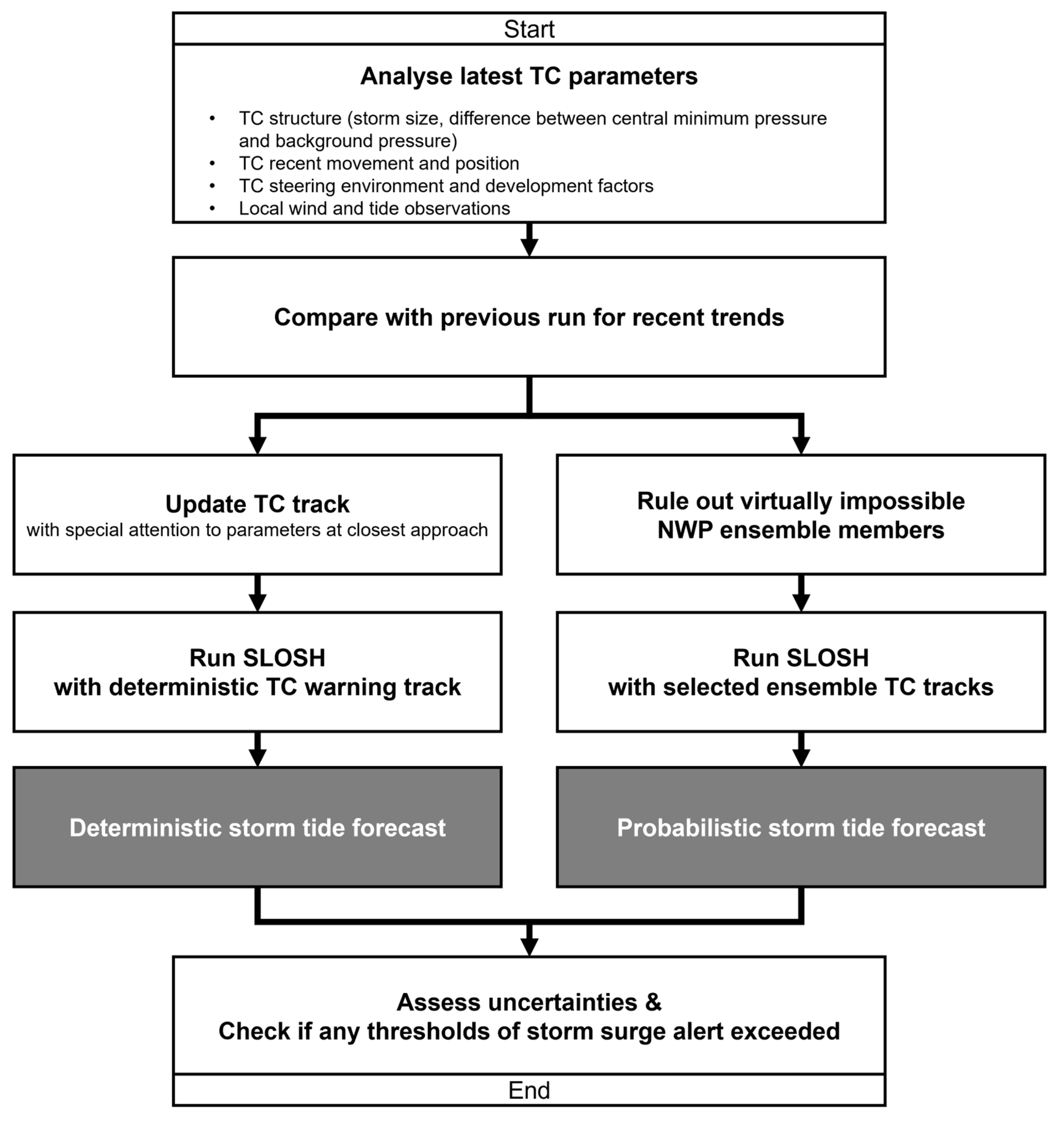
Storm surge heights could be highly sensitive to the storm size and TC intensity when the circulation of the TC affects the region as shown in the case of Saola. Using multiple sources of observations to closely monitor the evolution of TC intensity and storm size with rapid-update real-time analysis based on the latest observations is vital for accurate deterministic storm surge forecasting. This nowcasting approach may also be useful to exclude some EPS members from generating probabilistic forecasts by using near real-time verification results and taking the Bayesian approach as time evolves. Satellite and radar imageries with high spatial and temporal resolution as well as surface observations are used to perform TC analysis and the verification of TC parameter forecasts, providing the basis for updating or refining the TC track, intensity and storm size forecast for use in storm surge prediction. The evaluation also includes the latest assessment of the time of closest approach, which is crucial to assess whether the maximum storm surge coincides with the astronomical high tide to worsen the situation. A workflow showing the analysis of key parameters in the rapid update nowcast cycle is given in
Figure 18.
With increasing observations over the ocean such as satellite-borne Synthetic Aperture Radar (SAR), weather radars and ocean radars, and buoys, the nowcast approach of rapid-update storm surge prediction can be performed in rapid update cycles as the situation warrants. To enhance the storm surge alert/warning service for disaster prevention and mitigation, the efficient dissemination of forecast updates and effective communication with decision makers to facilitate their emergency preparedness and response are also critical factors for success.
8. Conclusions
Super Typhoon Saola brought a storm surge to Hong Kong during its close passage on 1 September 2023. Storm surge alert thresholds were exceeded in some areas, particularly those along the eastern coast. With the use of re-analysed TC positions, intensity and storm size, the storm surge predictions produced by SLOSH generally agreed well with the observed storm tide over different regions of Hong Kong. Despite the limitations of SLOSH as a circularly symmetric parametric model, SLOSH is flexible and computationally efficient to provide reasonably good storm surge predictions for risk assessment of coastal flooding and sea inundation in Hong Kong, which is a small and densely populated city. Owing to the compact circulation of Saola and its close proximity to Hong Kong during its closest approach, the prediction of storm surges was challenging 48 h ahead or even 24 h before the event, due to the high sensitivity of the storm surge forecast to the storm size and distance to the region of interest. The extent and severity of storm surges could be significantly different if there were any changes in the TC parameters, such as the speed of the TC movement, which might lead to perfect matching of the timing of the maximum storm surge and the astronomical high tide, or if the storm size was larger with a more extensive area of hurricane-force wind, Saola might have brought a record-breaking storm tide to Hong Kong.
The sensitivity test results showed that storm surges can be substantially different when the storm size and/or the distance of closest approach are slightly different in cases of a direct hit or a close call of a compact and intense tropical cyclone like Saola. Hence, the rapid-update real-time analysis of TC parameters including TC position, speed of movement, intensity and storm size based on the latest observations, together with the application of nowcasting techniques in forecasting changes in these parameters in the next 6–12 h, is a pragmatic way of minimising the degree of uncertainty and increasing the accuracy in producing the latest storm surge deterministic forecast for decision makers, which is crucial for them to make the final call for any action plan of costly emergency response actions such as evacuation. This nowcasting approach can also be adopted in producing probabilistic forecasts for risk assessment of coastal flooding and sea inundation.
To evaluate forecast uncertainties, the probabilistic storm surge prediction system used by the HKO, PRIMES, was tested to be reliable to cover the potential worst scenario and also provided useful hints to the most probable outcome. While the statistical method can give a possible range of storm surge forecasts taking into account the previous performance in the TC track and intensity forecasts, the dynamical method, on the other hand, can provide a more refined range of alternative scenarios as time progresses. Combined with more frequent updates of the TC forecast and model that are run with a better understanding of the spread of ensemble forecasts, forecasters should be able to refine the forecast with a higher level of confidence as time progresses and operate an early warning/alerting service of storm surges more effectively. The early formulation of warning strategies is made possible by using probabilistic forecasts taking into account the flow-dependent uncertainties. A 50% exceedance height forecast can be considered in a time frame a couple of days ahead for emergency planning, while a higher-probability exceedance height forecast can be considered for a lead time of 12–24 h. By making use of the storm surge forecast and alerting service provided by the HKO, emergency response agencies and the general public in Hong Kong could be better prepared and take response actions based on the latest assessment of storm surge and sea level forecasts to avoid possible losses.
As EPS can predict the flow-dependent consequences of inevitable uncertainties, it should be more superior than the use of a solely statistical method in producing storm surge probabilistic forecasts. Coupling it with storm surge model and artificial intelligence (AI) techniques in the nowcasting regime will be the future work of storm surge forecast development in the HKO. The design of a GIS-based visualisation tool to facilitate the risk assessment of coastal flooding or sea inundation by decision makers will also be pursued.
Using coupled air–sea numerical models to generate storm surge forecasts is also possible for reference use and comparison, but attention should be paid to the limitations of using numerical model storm surge products and the fact that they lack the flexibility of easy modification of input parameters. Also, running numerical models could be computationally expensive for operational use. Abrupt changes in TC parameters could occur when the TC is close to the coastal region, about to make landfall or interacting with other weather systems. Storm surge forecasting for a direct hit or close call of a super typhoon like Saola is a real challenge. However, it was illustrated in this paper that adopting a nowcasting approach to analyse the TC structure using surface observations and remote-sensing data and to predict very short-term changes together with the use of a computationally efficient storm surge model are operationally viable to tackle the challenge of regional storm surge predictions in cases of a direct hit or close call of compact and intense TCs in an operational environment.
Author Contributions
Conceptualisation, C.-C.L. and P.-W.C.; methodology, D.-S.L., W.-S.C. and C.-C.L.; software, D.-S.L. and W.-S.C.; validation, D.-S.L. and W.-S.C.; formal analysis, D.-S.L., W.-S.C. and C.-C.L.; investigation, D.-S.L., W.-S.C. and C.-C.L.; resources, C.-C.L. and P.-W.C.; data curation, D.-S.L. and W.-S.C.; writing—original draft preparation, D.-S.L., W.-S.C. and C.-C.L.; writing—review and editing, Y.-C.W. and C.-C.L.; visualisation, D.-S.L., C.-C.L. and Y.-C.W.; supervision, C.-C.L. and P.-W.C.; project administration, C.-C.L. and P.-W.C. All authors have read and agreed to the published version of the manuscript.
Funding
This research received no external funding.
Institutional Review Board Statement
Not applicable.
Informed Consent Statement
Not applicable.
Data Availability Statement
The data are available upon reasonable request to the Hong Kong Observatory. The data are not publicly available due to privacy.
Conflicts of Interest
The authors declare no conflicts of interest.
References
- Ng, M.C.; Lui, W.H.; Yeung, W.L.; Mok, H.Y. Storm Surge Risk Assessment in Hong Kong during the Passage of Super Typhoon Usagi. In Proceedings of the 28th Guangdong-Hong Kong-Macao Seminar on Meteorological Science and Technology; Hong Kong, China, 13–15 January 2014. Available online: https://www.hko.gov.hk/en/publica/reprint/files/r1096.pdf (accessed on 21 November 2023).
- Qiang, Y.; He, J.; Xian, T.; Lu, W.; Li, J.; Zhang, L. Coastal town flooding upon compound rainfall-wave-overtopping-storm surge during extreme tropical cyclones in Hong Kong. J. Hydrol. Reg. Stud. 2021, 37, 100890. [Google Scholar] [CrossRef]
- Mok, H.Y.; Lui, W.H.; Lau, D.S.; Woo, W.C. Reconstruction of the track and a simulation of the storm surge associated with the calamitous typhoon affecting the Pearl River Estuary in September 1874. Clim. Past 2020, 16, 51–64. [Google Scholar] [CrossRef]
- Mok, H.Y.; Shun, C.M.; Davies, S.; Lui, W.H.; Lau, D.S.; Cheung, K.C.; Kong, K.Y.; Chan, S.T. A historical re-analysis of the calamitous midget typhoon passing through Hong Kong on 18 September 1906 and its storm surge impact to Hong Kong. Trop. Cyclone Res. Rev. 2022, 11, 174–218. [Google Scholar] [CrossRef]
- Watts, I.E.M. The effect of meteorological conditions on tide height at Hong Kong. In Hong Kong Observatory Technical Memoir; Jenner, W.F.C., Ed.; Government Printer: Hong Kong, China, 1959; Volume 8. [Google Scholar]
- Cheng, T.T. Storm Surges in Hong Kong. In Hong Kong Observatory Technical Note; No. 26.; Royal Observatory: Hong Kong, China, 1967. Available online: https://www.hko.gov.hk/en/en/en/en/publica/tn/files/tn026.pdf (accessed on 21 November 2023).
- Peterson, P. Storm Surge Statistics. In Hong Kong Observatory Technical Note (Local); Royal Observatory: Hong Kong, China, 1975; No. 20. Available online: https://www.hko.gov.hk/en/publica/tnl/files/tnl020.pdf (accessed on 21 November 2023).
- Choy, C.W.; Lau, D.S.; He, Y.H. Super typhoons Hato and Mangkhut, part II: Challenges in forecasting and early warnings. Weather 2022, 77, 324–331. [Google Scholar] [CrossRef]
- Choy, C.W.; Lau, D.S.; He, Y.H. Super typhoons Hato and Mangkhut, part I: Analysis of maximum intensity and wind structure. Weather 2022, 77, 314–320. [Google Scholar] [CrossRef]
- Chan, P.W.; He, Y.H.; Lui, Y.S. Super Typhoon Saola (2309) affecting Hong Kong in September 2023–Forecasting Aspect. Preprints 2023, 2023091634. [Google Scholar] [CrossRef]
- Chan, P.W.; Choy, C.W.; Chiu, Y.Y. Observational study of Super Typhoon Saola in 2023 when it was close to Hong Kong. Preprints 2023, 2023091688. [Google Scholar] [CrossRef]
- Jelesnianski, C.P.; Chen, J.; Shaffer, W.A. SLOSH: Sea, Lake, and Overland Surges from Hurricane. In NOAA Technical Report; National Weather Service: Silver Spring, MD, USA, 1992; Volume 48, pp. 13–15. [Google Scholar]
- Forbes, C.; Rhome, J.; Mattocks, C.; Taylor, A. Predicting the storm surge threat of Hurricane Sandy with the National Weather Service SLOSH model. J. Mar. Sci. Eng. 2014, 2, 437–476. [Google Scholar] [CrossRef]
- GEBCO Bathymetric Compilation Group 2020. The GEBCO 2020 Grid—A Continuous Terrain Model of the Global Oceans and Land; British Oceanographic Data Centre; Liverpool, UK, National Oceanography Centre: Southampton, UK; NERC: Swindon, UK, 2020. [Google Scholar] [CrossRef]
- Taylor, A.A.; Glahn, B. Probabilistic guidance for hurricane storm surge. In Proceedings of the 19th Conference on Probability and Statistics, New Orleans, LA, USA, 20–24 January 2008; Available online: https://ams.confex.com/ams/88Annual/webprogram/Paper132793.html (accessed on 21 November 2023).
- MTCSWA. Available online: https://www.ssd.noaa.gov/PS/TROP/mtcswa.html (accessed on 21 November 2023).
- ARCHER. Available online: https://tropic.ssec.wisc.edu/real-time/archerOnline/web/index.shtml (accessed on 21 November 2023).
- ASCAT. Available online: https://manati.star.nesdis.noaa.gov/datasets/ASCATData.php (accessed on 21 November 2023).
- Palmer, T. The ECMWF ensemble prediction system: Looking back (more than) 25 years and projecting forward 25 years. 2019, 145 (Suppl. 1), 12–24. Available online: https://rmets.onlinelibrary.wiley.com/doi/epdf/10.1002/qj.3383 (accessed on 21 November 2023).
Figure 1.
Locations of selected tide gauge, water level gauge and wind stations in Hong Kong.
Figure 1.
Locations of selected tide gauge, water level gauge and wind stations in Hong Kong.
Figure 2.
Provisional best track of Super Typhoon Saola analysed by the HKO (HKT = UTC + 8 h).
Figure 2.
Provisional best track of Super Typhoon Saola analysed by the HKO (HKT = UTC + 8 h).
Figure 3.
Time series of the sea level recorded (blue line) and the astronomical tide (red line) at Tai Po Kau (TPK) during the passage of Super Typhoon Saola on 1–2 September 2023. Heights are shown in metres above Chart Datum.
Figure 3.
Time series of the sea level recorded (blue line) and the astronomical tide (red line) at Tai Po Kau (TPK) during the passage of Super Typhoon Saola on 1–2 September 2023. Heights are shown in metres above Chart Datum.
Figure 4.
Time series of the wind speed and direction at (a) Tai Mei Tuk and (b) Tap Mun, from midday of 1 September to midday of 2 September 2023.
Figure 4.
Time series of the wind speed and direction at (a) Tai Mei Tuk and (b) Tap Mun, from midday of 1 September to midday of 2 September 2023.
Figure 5.
Time sequence of surface winds in the vicinity of Tolo Harbour between 20:00 and 23:30 H on 1 September 2023, an episode capturing the most intense wind speed over the region during the passage of Saola. Red frames mark the start and end time of a period during which the highest rate of rising water level was observed.
Figure 6.
(a) False-colour satellite image at 06 UTC on 31 August 2023, captured by the Himawari-9 satellite from Japan Meteorological Agency; (b) NOAA Multiplatform TC Surface Winds Analysis valid for the same time with winds of ≥ 34, 50, 64 and 95 kt coloured in yellow, orange, red and grey respectively and the derived RMW given at the bottom of the figure.
Figure 7.
(a) Doppler wind field of radar at Tai Mo Shan in Hong Kong. A 0.1 deg PPI scan at (a) 00 UTC and (b) 10 UTC on 1 September 2023. (HKT = UTC + 8 h).
Figure 7.
(a) Doppler wind field of radar at Tai Mo Shan in Hong Kong. A 0.1 deg PPI scan at (a) 00 UTC and (b) 10 UTC on 1 September 2023. (HKT = UTC + 8 h).
Figure 8.
Time series of predicted storm surge and sea level (in mCD) based on provisional best-track parameters, along with observed sea level and astronomical tide at (a) QUB and (b) TPK during the closest approach of Saola on 1 September 2023.
Figure 8.
Time series of predicted storm surge and sea level (in mCD) based on provisional best-track parameters, along with observed sea level and astronomical tide at (a) QUB and (b) TPK during the closest approach of Saola on 1 September 2023.
Figure 9.
Tracks of Saola in the sensitivity test regarding the distance of closest approach to Hong Kong.
Figure 9.
Tracks of Saola in the sensitivity test regarding the distance of closest approach to Hong Kong.
Figure 10.
Sensitivity test regarding the storm size of Saola. The red line is the actual track of Saola. The circles of different radii around the point of closest approach illustrate the storm sizes that were tested.
Figure 10.
Sensitivity test regarding the storm size of Saola. The red line is the actual track of Saola. The circles of different radii around the point of closest approach illustrate the storm sizes that were tested.
Figure 11.
Hypothetical tracks of PRIMES for the model run at 06 UTC on (a) 31 August and (b) 1 September 2023.
Figure 11.
Hypothetical tracks of PRIMES for the model run at 06 UTC on (a) 31 August and (b) 1 September 2023.
Figure 12.
Probabilistic plume map for storm tide forecast at TPK based on the model run with initial time at 06 UTC on (a) 31 August and (b) 1 September 2023. The white dashed line indicates the most probable storm tide height.
Figure 12.
Probabilistic plume map for storm tide forecast at TPK based on the model run with initial time at 06 UTC on (a) 31 August and (b) 1 September 2023. The white dashed line indicates the most probable storm tide height.
Figure 13.
Probabilistic plume map for storm tide forecast at QUB based on the model run with initial time at 06 UTC on (a) 31 August and (b) 1 September 2023. The white dashed line indicates the most probable storm tide height.
Figure 13.
Probabilistic plume map for storm tide forecast at QUB based on the model run with initial time at 06 UTC on (a) 31 August and (b) 1 September 2023. The white dashed line indicates the most probable storm tide height.
Figure 14.
The 50% exceedance height of storm tide (in mCD) based on the model run of PRIMES at 06 UTC on (a) 31 August and (b) 1 September 2023.
Figure 14.
The 50% exceedance height of storm tide (in mCD) based on the model run of PRIMES at 06 UTC on (a) 31 August and (b) 1 September 2023.
Figure 15.
Same as
Figure 14 (at 06 UTC on (
a) 31 August and (
b) 1 September 2023) but for 90% exceedance height of storm tide.
Figure 15.
Same as
Figure 14 (at 06 UTC on (
a) 31 August and (
b) 1 September 2023) but for 90% exceedance height of storm tide.
Figure 16.
Probabilistic ensemble approach based on 51 ECMWF EPS member forecasts with model initial time at 12 UTC on 31 August 2023. Grey lines are the ECMWF EPS member forecast tracks, whereas the orange dashed line shows the ensemble mean track.
Figure 16.
Probabilistic ensemble approach based on 51 ECMWF EPS member forecasts with model initial time at 12 UTC on 31 August 2023. Grey lines are the ECMWF EPS member forecast tracks, whereas the orange dashed line shows the ensemble mean track.
Figure 17.
(a) 50% and (b) 90% exceedance heights of storm tide (in mCD) based on the PRIMES output using ECMWF EPS forecasts initialised at 12 UTC on 31 August 2023.
Figure 17.
(a) 50% and (b) 90% exceedance heights of storm tide (in mCD) based on the PRIMES output using ECMWF EPS forecasts initialised at 12 UTC on 31 August 2023.
Figure 18.
Workflow of rapid-update storm surge nowcasting.
Figure 18.
Workflow of rapid-update storm surge nowcasting.
Table 1.
Records of significant storm surge in Hong Kong.
Table 1.
Records of significant storm surge in Hong Kong.
| TC Name | Year | Victoria Harbour | Tolo Harbour |
|---|
Max Storm Surge
(m) 1 | Max Storm Tide
(mCD) 2 | Max Storm Surge
(m) 1 | Max Storm Tide
(mCD) 2 |
|---|
| - | 1874 | 2.83 * | 4.88 * | 2.83 * | 4.95 * |
| - | 1906 | 0.39 * | 2.53 * | 1.98 * | 4.15 * |
| - | 1937 | 1.98 ^ | 4.05 ^ | 3.81^ | 6.25 ^ |
| Wanda | 1962 | 1.77 | 3.96 | 3.20 | 5.03 |
| Hope | 1979 | 1.45 | 2.78 | 3.23 | 4.33 |
| Hagupit | 2008 | 1.43 | 3.53 | 1.77 | 3.77 |
| Hato | 2017 | 1.18 | 3.57 | 3.23 | 4.09 |
| Mangkhut | 2018 | 2.35 | 3.88 | 3.40 | 4.71 |
Table 2.
Recorded maximum storm surge and maximum storm tide at various locations of Hong Kong during the passage of Super Typhoon Saola from 1 to 2 September 2023.
Table 2.
Recorded maximum storm surge and maximum storm tide at various locations of Hong Kong during the passage of Super Typhoon Saola from 1 to 2 September 2023.
| Station | Max Storm Surge
(m) 1 | Max Storm Tide
(mCD) 2 |
|---|
| Tai Po Kau | 1.48 | 3.32 |
| Quarry Bay | 0.76 | 3.07 |
| Shek Pik | 0.72 | 3.07 |
| Tai Miu Wan | 0.91 | 3.02 |
| Tsim Bei Tsui | 0.73 | 3.41 |
| Ko Lau Wan ^ | 1.23 | 3.00 |
| Tai O * | 0.88 | 3.19 |
| Tai Po River ** | 2.20 # | 3.89 |
| Sai Kung ** | 2.75 # | 4.52 |
Table 3.
Standard deviation of cross-track, along-track and pressure errors of forecast hours between 2016 and 2020.
Table 3.
Standard deviation of cross-track, along-track and pressure errors of forecast hours between 2016 and 2020.
Forecast Lead Times
(Hours) | Standard Deviation |
|---|
Along-Track Error
(ATE) (km) | Cross-Track Error
(CTE) (km) | Pressure Error
(PE) (hPa) |
|---|
| 0 | 7.3 | 3.5 | 2.1 |
| 6 | 16.8 | 11.7 | 2.8 |
| 12 | 27.5 | 22.6 | 3.5 |
| 18 | 35.8 | 28.1 | 4.2 |
| 24 | 43.4 | 38.2 | 4.8 |
| 30 | 56.5 | 45.0 | 5.5 |
| 36 | 63.8 | 52.1 | 6.2 |
| 42 | 78.9 | 62.3 | 6.8 |
| 48 | 94.8 | 65.9 | 7.7 |
| 54 | 102.8 | 80.2 | 8.1 |
| 60 | 121.0 | 86.0 | 8.7 |
| 66 | 128.5 | 98.7 | 9.3 |
| 72 | 147.8 | 107.1 | 9.6 |
| 78 | 155.8 | 117.6 | 10.5 |
| 84 | 162.4 | 130.3 | 11.1 |
| 90 | 184.7 | 137.0 | 11.6 |
| 96 | 197.3 | 153.3 | 12.4 |
| 102 | 215.3 | 157.0 | 12.7 |
| 108 | 222.9 | 172.7 | 13.3 |
| 114 | 247.5 | 177.5 | 13.8 |
| 120 | 272.5 | 180.0 | 14.3 |
Table 4.
Provisional best-track analysis of Saola.
Table 4.
Provisional best-track analysis of Saola.
| Date | Time
(UTC) | Estimated
Minimum
Central Pressure
(hPa) | Latitude
(°N) | Longitude
(°E) | Storm Size
(km) |
|---|
| 30/8 | 15 | 915 | 20.9 | 119.2 | 28 |
| | 21 | 920 | 20.9 | 118.7 | 28 |
| 31/8 | 03 | 925 | 21.1 | 117.9 | 28 |
| | 09 | 930 | 21.4 | 117.6 | 24 |
| | 15 | 930 | 21.5 | 117.1 | 24 |
| | 21 | 925 | 21.7 | 116.6 | 24 |
| 1/9 | 03 | 930 | 21.9 | 115.9 | 18 |
| | 09 | 935 | 21.9 | 115.0 | 15 |
| (Closest Approach) | 15 | 950 | 21.9 | 114.1 | 13 |
| | 21 | 968 | 21.8 | 113.2 | 13 |
| 2/9 | 03 | 978 | 21.7 | 112.4 | 13 |
Table 5.
The predicted and observed maximum storm surge and storm tide at the closest approach of Saola to Hong Kong near midnight of 1 September 2023.
Table 5.
The predicted and observed maximum storm surge and storm tide at the closest approach of Saola to Hong Kong near midnight of 1 September 2023.
| Station | Predicted
Max Storm Surge
(m) 1 | Observed
Max Storm Surge
(m) 1 | Predicted
Max Storm Tide
(mCD) 2 | Observed
Max Storm Tide
(mCD) 2 |
|---|
| QUB | 0.87 | 0.76 | 2.64 | 2.58 |
| TPK | 1.41 | 1.48 | 3.28 | 3.32 |
| TAO | 1.00 | 0.88 | 2.86 | 2.99 |
Table 6.
Storm tide simulation results in the sensitivity test of the distance of closest approach of Saola to Hong Kong.
Table 6.
Storm tide simulation results in the sensitivity test of the distance of closest approach of Saola to Hong Kong.
| Station | Simulated Max Storm Tide | Observed
Max. Storm Tide |
|---|
Provisional
Best-Track Analysis | Shifted North
by 20 km | Shifted North
by 10 km | Shifted South
by 10 km |
|---|
| QUB | 2.64 mCD | 2.91 mCD | 2.71 mCD | 2.57 mCD | 2.58 mCD |
| TPK | 3.28 mCD | 4.17 mCD | 3.64 mCD | 3.03 mCD | 3.32 mCD |
| TAO | 2.86 mCD | 2.78 mCD | 2.78 mCD | 2.83 mCD | 2.99 mCD |
Table 7.
Storm tide simulation results in the sensitivity test of storm size of Saola during its closest approach to Hong Kong.
Table 7.
Storm tide simulation results in the sensitivity test of storm size of Saola during its closest approach to Hong Kong.
| Station | Simulated Max Storm Tide | Observed
Max. Storm Tide |
|---|
Provisional
Best-Track Analysis | Storm Size of
28 km | Storm Size of
23 km | Storm Size of
10 km |
|---|
| QUB | 2.64 mCD | 3.35 mCD | 3.06 mCD | 2.28 mCD | 2.58 mCD |
| TPK | 3.28 mCD | 4.75 mCD | 4.27 mCD | 2.73 mCD | 3.32 mCD |
| TAO | 2.86 mCD | 3.02 mCD | 2.92 mCD | 2.75 mCD | 2.99 mCD |
| Disclaimer/Publisher’s Note: The statements, opinions and data contained in all publications are solely those of the individual author(s) and contributor(s) and not of MDPI and/or the editor(s). MDPI and/or the editor(s) disclaim responsibility for any injury to people or property resulting from any ideas, methods, instructions or products referred to in the content. |
© 2023 by the authors. Licensee MDPI, Basel, Switzerland. This article is an open access article distributed under the terms and conditions of the Creative Commons Attribution (CC BY) license (https://creativecommons.org/licenses/by/4.0/).
