Abstract
Comprehensive understanding of the spatial characteristics of tropical cyclone (TC) precipitation is essential for effective socioeconomic planning and scientific research. The present study examines the spatial asymmetry in TC precipitation over the western North Pacific (WNP) concerning various factors, including latitudes, sea surface temperature (SST), TC intensity, and translation speed, based on satellite observations. The results reveal a significant poleward migration of TC precipitation asymmetry particularly above 15° N. Furthermore, the asymmetry exhibits considerable sensitivity to changes in TC center latitudes and SSTs, characterized by anticlockwise and northeastward migration, respectively. The poleward migration of TC precipitation spatial asymmetry is primarily due to the poleward decreasing SST, increasing vertical wind shear and increasing TC translation speed. These findings contribute to a comprehensive understanding of TC behavior over the WNP and provide valuable insights for disaster preparedness and mitigation efforts.
1. Introduction
Tropical cyclones (TCs) are one of the most destructive weather phenomena, characterized by strong winds and heavy precipitation, that can have significant impacts on human society [1,2]. With major impacts of precipitation, TCs can be both beneficial and detrimental, with the potential to replenish freshwater resources while also causing floods and landslides [3,4,5]. Therefore, a better understanding of the precipitation characteristics of TCs is essential for mitigating their potential impacts [6,7].
Previous studies have reported that TC precipitation is spatial asymmetric in global oceans [8,9,10,11,12]. This asymmetry is mainly influenced by TC translation, and oceanic and atmospheric conditions, among which vertical wind shear (VWS) [10,13,14,15,16] and sea surface temperature (SST) [17,18,19] are two crucial factors affecting TC precipitation and its spatial asymmetry. VWS, which is the difference in winds between the upper and lower levels of the atmosphere, can disrupt the organization of TCs and inhibit their development or intensification [20,21,22]. Based on satellite observed results, several previous studies [10,13] found that TC precipitation is displaced at the downshear-left side for the northern hemisphere and this asymmetry grows with increasing VWS consistent with many other studies. Liang and Chan [8] proposed an effective VWS as a function of TC intensity and core regions and suggested a better performance in explaining TC precipitation asymmetry in the outer core. The upper ocean is the heat and moisture source for the TC, and SST is essential in determining the air–sea flux to the TC [23,24,25,26,27]. The increased moisture accompanied by increased SST leads to higher amounts of precipitation within TCs [17,18,19,28]. Based on satellite observations and model simulations, Lin et al. [28] found that the TC precipitation rate is primarily controlled by absolute SST, and the area of precipitation is mainly controlled by the relative magnitude of SST in the TC local environment concerning the tropical mean value. Kim et al. [29] suggested that environmental flow plays a key role in controlling the areal extents of TC precipitation in the subtropics, where TCs are exposed to cooler SSTs and stronger environmental flows than the tropics, which induces more asymmetric TC precipitation. The recent study by Tu et al. [30] reported that the increase in the TC translation speed can also increase the asymmetry of TC precipitation.
The WNP is one of the most threatened basins by TCs, with one-third TCs on Earth occurring each year. These TCs causes significant socioeconomic influences on several coastal countries. Under global warming circumstances, TCs were observed and predicted to migrate poleward, thus leading to increasing influences on East Asia [31,32,33,34,35]. This requires a clear understanding of the spatial distribution of TC precipitation which is still not fully understood. In this study, the spatial distribution of TC precipitation over the WNP is investigated through ensemble analysis relative to the TC position, intensity, translation speed, SST, and VWS. The results of this study can promote a comprehensive understanding of TC precipitation over the WNP and provide important references for disaster prediction, prevention, and mitigation.
2. Data and Methods
The TC best track data used in the study were provided by the Joint Typhoon Warning Center (JTWC) and obtained from the International Best Track Archive for Climate Stewardship (IBTrACS) dataset [36,37]. This dataset provides information on the positions of the TC center and intensity variables per 6 h. Only TCs with a minimum intensity of 35 kt were considered in the analysis. TC occurrence used in this study is defined as the duration within 5° × 5° grids, taken as the accumulated counts of days each year when any TC centers were in that grid box.
The SST data were obtained from Remote Sensing Systems [38]. This daily product is optimally interpolated combining the capabilities of through-cloud using microwave (MW) sensors with high spatial resolution and near-coastal capability using infrared (IR) sensors and is available from June 2002 to the present at a 9 km × 9 km spatial resolution. The SST data for 7 days before the arrival of TCs were used to avoid SST changes induced by the TCs [39,40,41]. SST at the TC center is obtained using linear interpolation based on the grided SST data.
The precipitation data were from Tropical Rainfall Measuring Mission (TRMM) [42], which was primarily designed to provide accurate and frequent measurements of rainfall in the tropics using a suite of sensors and instruments aboard a satellite. The 3-h satellite observed precipitation product (3B42 version 7) records precipitation from 1998 to 2020, covering a 0.25° × 0.25° spatial resolution over the global Tropics.
The wind data were obtained from NCEP/NCAR Reanalysis 1 project [43], which is derived from a combination of observations and model simulations. The wind data are available over the period from 1948 to the present day at a 6-hourly temporal resolution and 2.5° × 2.5° spatial resolution with 17 vertical levels. The present study calculates vertical wind shear using the difference between winds at 200 and 850 hPa. To be consistent, all the data were used from 2003 to 2019 in the present study.
3. Results
3.1. TC Precipitation and Occurrence over the WNP
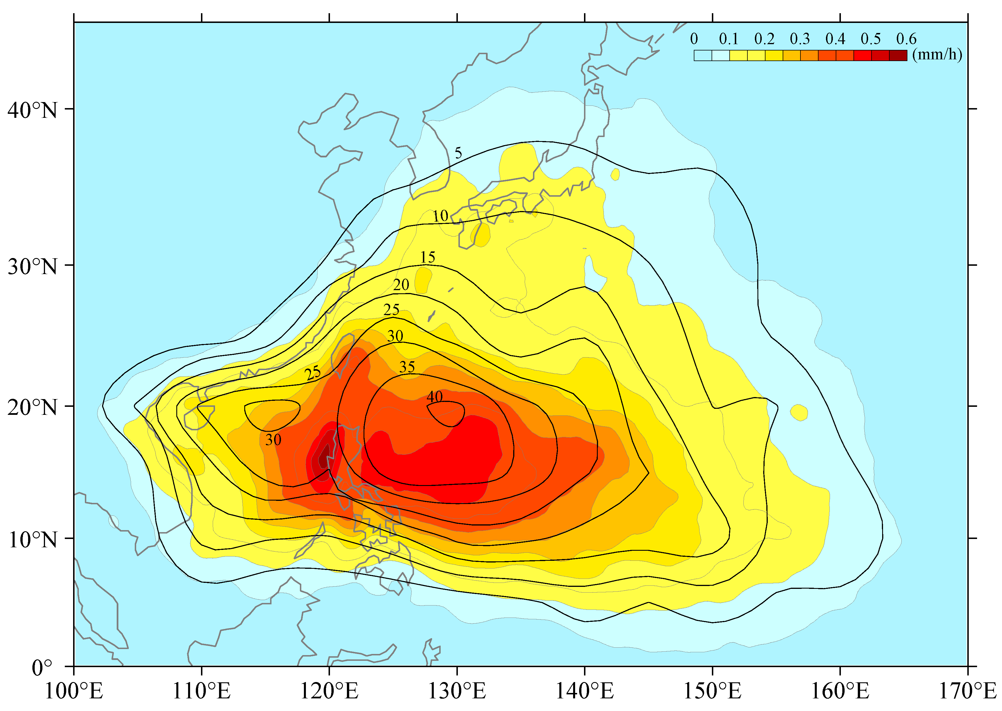
Figure 1 provides an overview of the averaged TC precipitation and accumulated TC occurrences during the whole TC period in the WNP. The figure shows that the maximum TC precipitation, with an average of 0.6 mm/h, occurs in two distinct regions along 16° N in the WNP and the South China Sea, respectively, and is likely due to the topographic effect. Furthermore, the figure reveals that the areas of peak TC precipitation are situated south of the peak TC occurrence, indicating a misalignment between the counters in TC precipitation and TC occurrence in both inner and outer TC rainbands. This observation suggests that the spatial distribution of TC precipitation is non-uniform over the WNP.
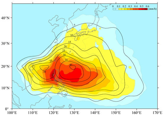
Figure 1.
TC precipitation (mm/h) averaged over the TC periods (colors) overlaid by the TC occurrence (days per year, contours) from 2003 to 2019.
3.2. Observed Spatial Asymmetry in TC Precipitation
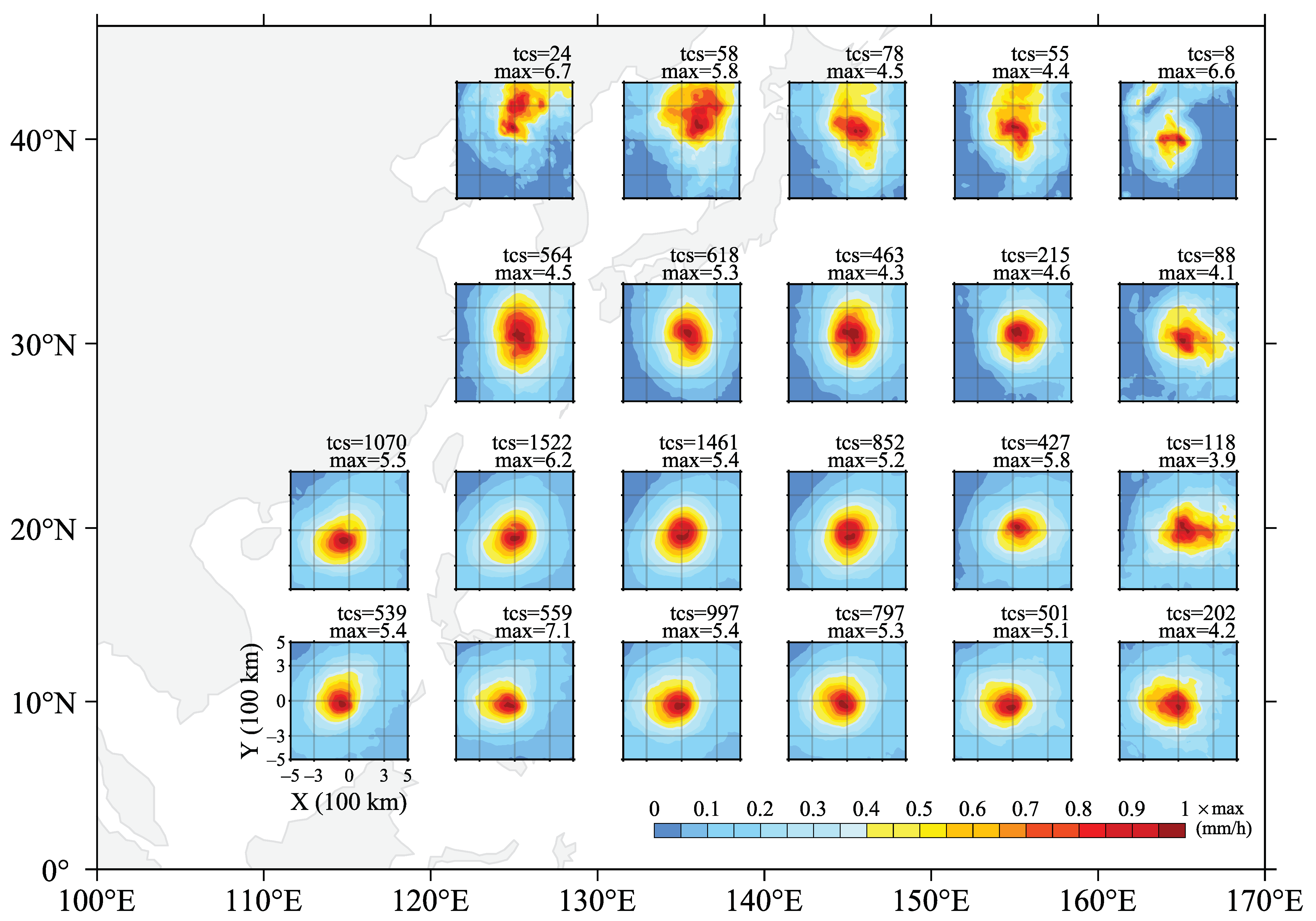
Figure 2 displays the spatial distributions of averaged TC precipitation as TC centers were found within 1000 km × 1000 km regions at varying locations over the WNP. The figure reveals that TC precipitation exhibits distinct asymmetric patterns, which change at various locations and show a significant poleward migration trend (Figure 2). As TC centers are below 25° N, the maximum precipitation is mainly located at the south side of the TC, explaining why the peaks of TC precipitation are observed south of the peaks in TC occurrence (Figure 1). As TC centers move poleward, more TC precipitation appears on the north side of the TC, and the maximum precipitation shifts to Quadrant I. Additionally, with increasing latitudes, the asymmetry of TC precipitation becomes more pronounced, with more precipitation observed in the northern outer areas about 300–500 km from the TC centers. To investigate possible reasons for the spatial asymmetry and poleward migration trend of the TC precipitation, the present study calculated the ensemble mean results of TC precipitation using all TC observations from 2003–2019 based on different TC and environmental condition parameters, including the latitudes and SST magnitudes at the TC center, and the TC intensity and translation speed.
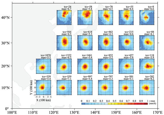
Figure 2.
Spatial distributions of TC precipitation averaged in 1000 × 1000 km regions centering TC centers at varying locations over the WNP from 2003 to 2019 (colors denote the proportions of TC precipitation compared with the maximum value). The maximum value and count of TC samples (tcs) are labeled at the top-right corner of each subplot.
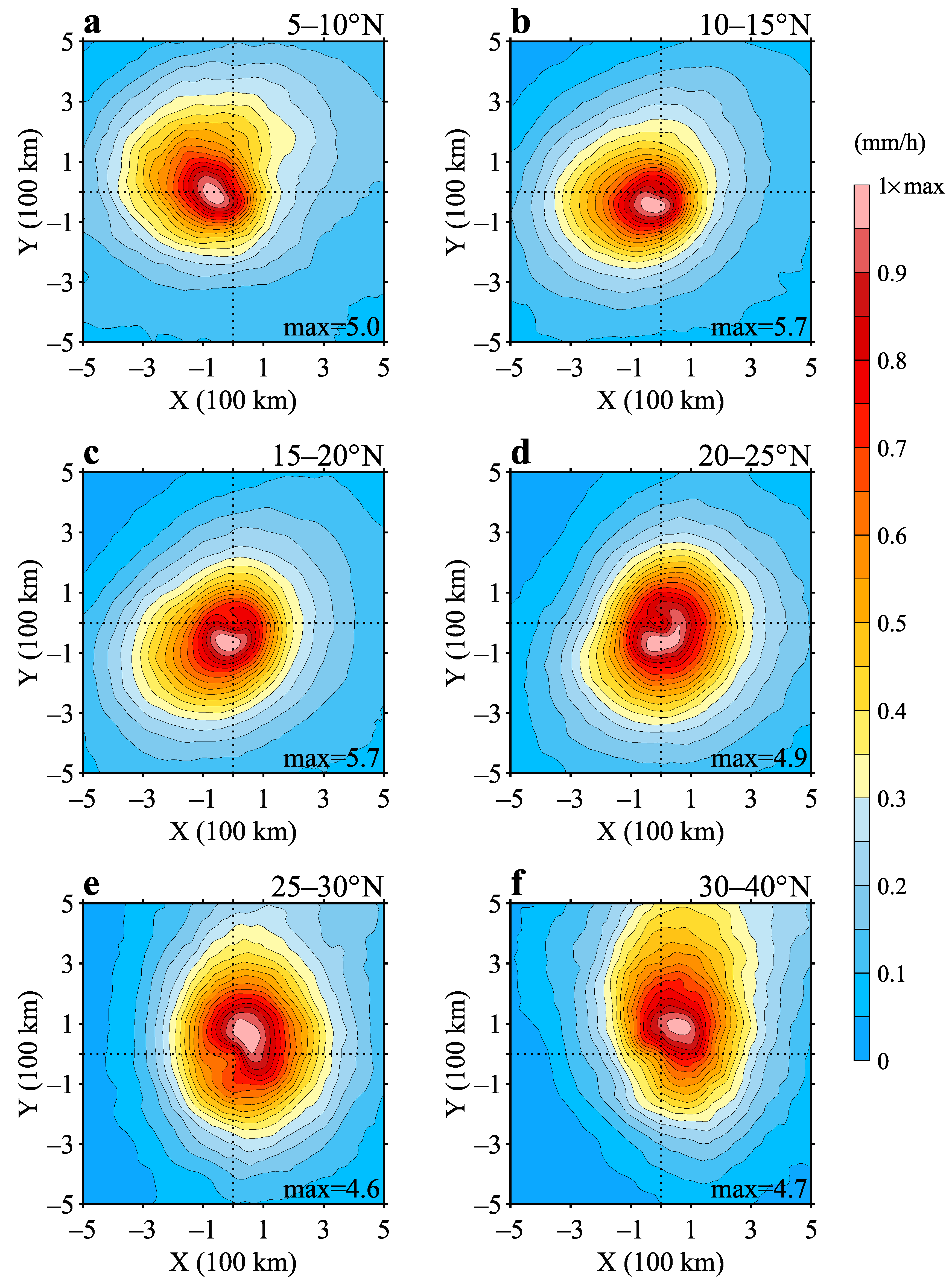
Figure 3 illustrates the averaged TC precipitation relative to the latitudes of the TC center. As the figure depicted, the spatial distribution of TC precipitation exhibits significant asymmetry depending on the latitude of the TC center. For TCs located at 5–10° N, more precipitation is observed in Quadrant II where the maximum precipitation is also observed (Figure 3a). As TCs move northward, the major precipitation areas (represented by the equipluves of 30% maximum precipitation) and positions of maximum precipitation all move in an anticlockwise direction (Figure 3b–f). For TCs located at 10–20° N (Figure 3b,c), 20–25° N (Figure 3d), and 25–45° N (Figure 3e,f), the major precipitation areas are observed in Quadrant III, IV, and I, respectively. In addition to the anticlockwise rotation of major precipitation areas, a northward shift is also observed during poleward TC movement, particularly for TCs located north of 15° N. The major precipitation areas in 25–30° N (Figure 3e), and 30–40° N (Figure 3f) extend northward over 300 km and over 500 km, respectively, from the TC center. The results also indicate that the mean maximum of mean precipitation values is 5.0, 5.7, 5.7, 4.9, 4.6, and 4.7 mm/h for TC centers located at latitudes of 5–10° N, 10–15° N, 15–20° N, 20–25° N, 25–30° N, and 30–40° N, respectively, denoting that strong and weak precipitation occurs in mid-lower and high latitudes, respectively.
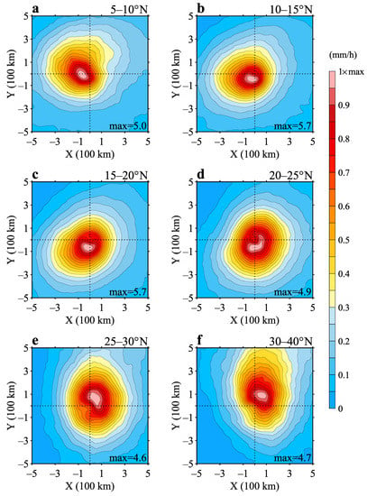
Figure 3.
Spatial distributions of TC precipitation averaged in 1000 × 1000 km regions centering TC centers from 2003 to 2019 relative to the latitudes of the TC centers. (a) 5–10° N; (b) 10–15° N; (c) 15–20° N; (d) 20–25° N; (e) 25–30° N; (f) 30–40° N (color denotes the proportions of TC precipitation compared with the maximum value which is labeled at the bottom-right corner of each subplot).
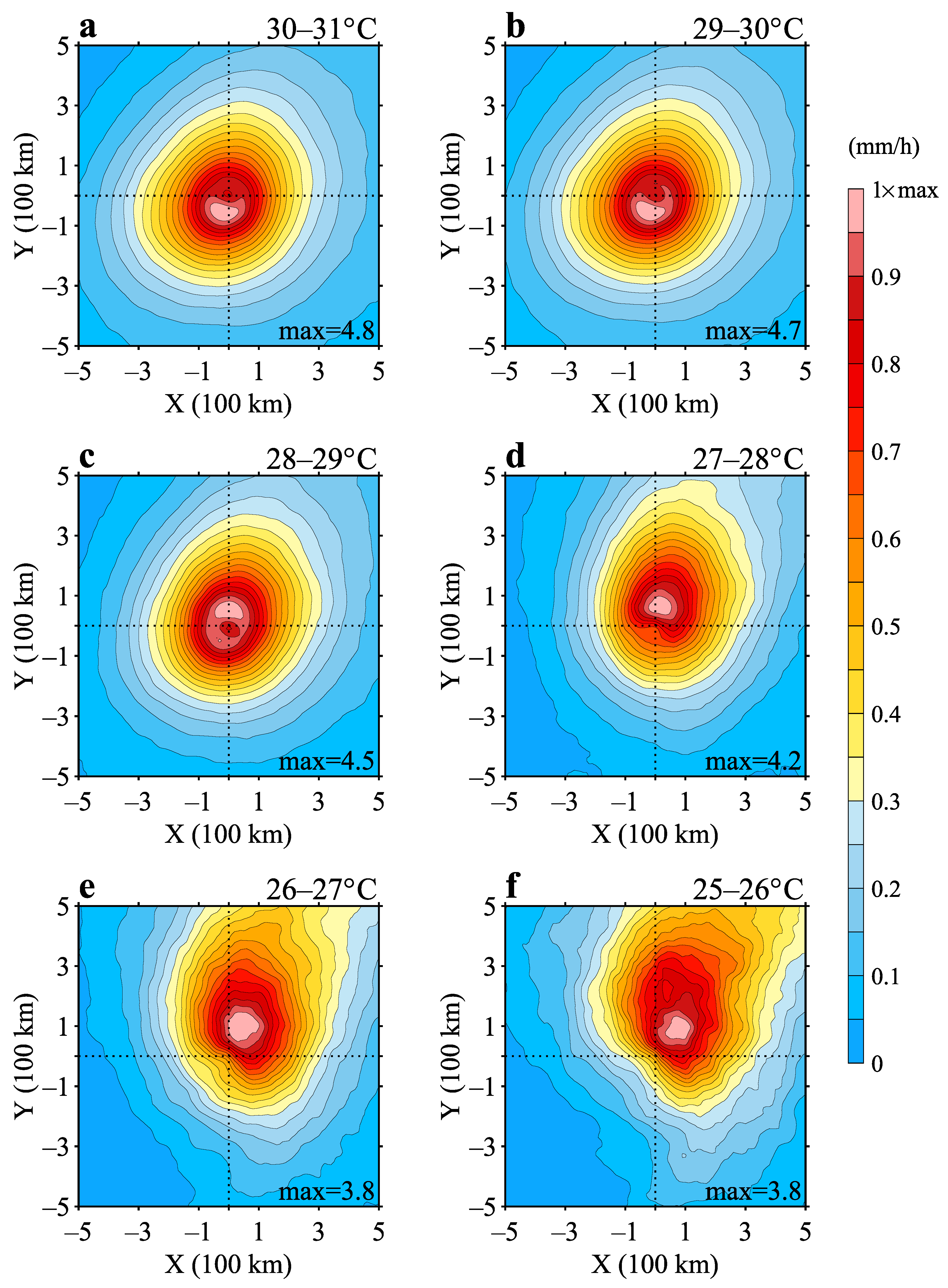
Figure 4 displays the spatial distribution of averaged TC precipitation relative to the SST magnitudes at the TC center. The results show that maximum TC precipitation decreases from 4.8 to 4.7 to 4.5 to 4.2 to 3.8 and 3.8 mm/h as the SST at the TC center decreased from 30–31 °C to 25–26 °C with 1 °C interval. During this period, the positions of maximum precipitation move northeastwards from Quadrant III to I, while the major precipitation areas extend from a quasi-symmetry pattern within 300 km to the TC center in 29–31 °C (Figure 4a,b) to northeastward-extending asymmetric structures outside 500 km to the TC center in 25–29 °C (Figure 4c–f). These results suggest that the magnitude and spatial distribution of TC precipitation are strongly influenced by SST.
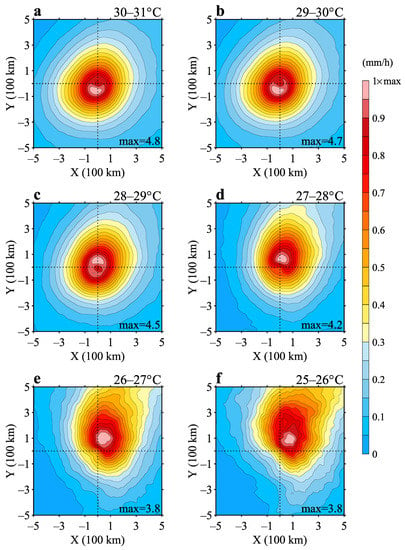
Figure 4.
Same as Figure 3 but relative to the SST values at the TC centers. (a) 30–31 °C; (b) 29–30 °C; (c) 28–29 °C; (d) 27–28 °C; (e) 26–27 °C; (f) 25–26 °C.
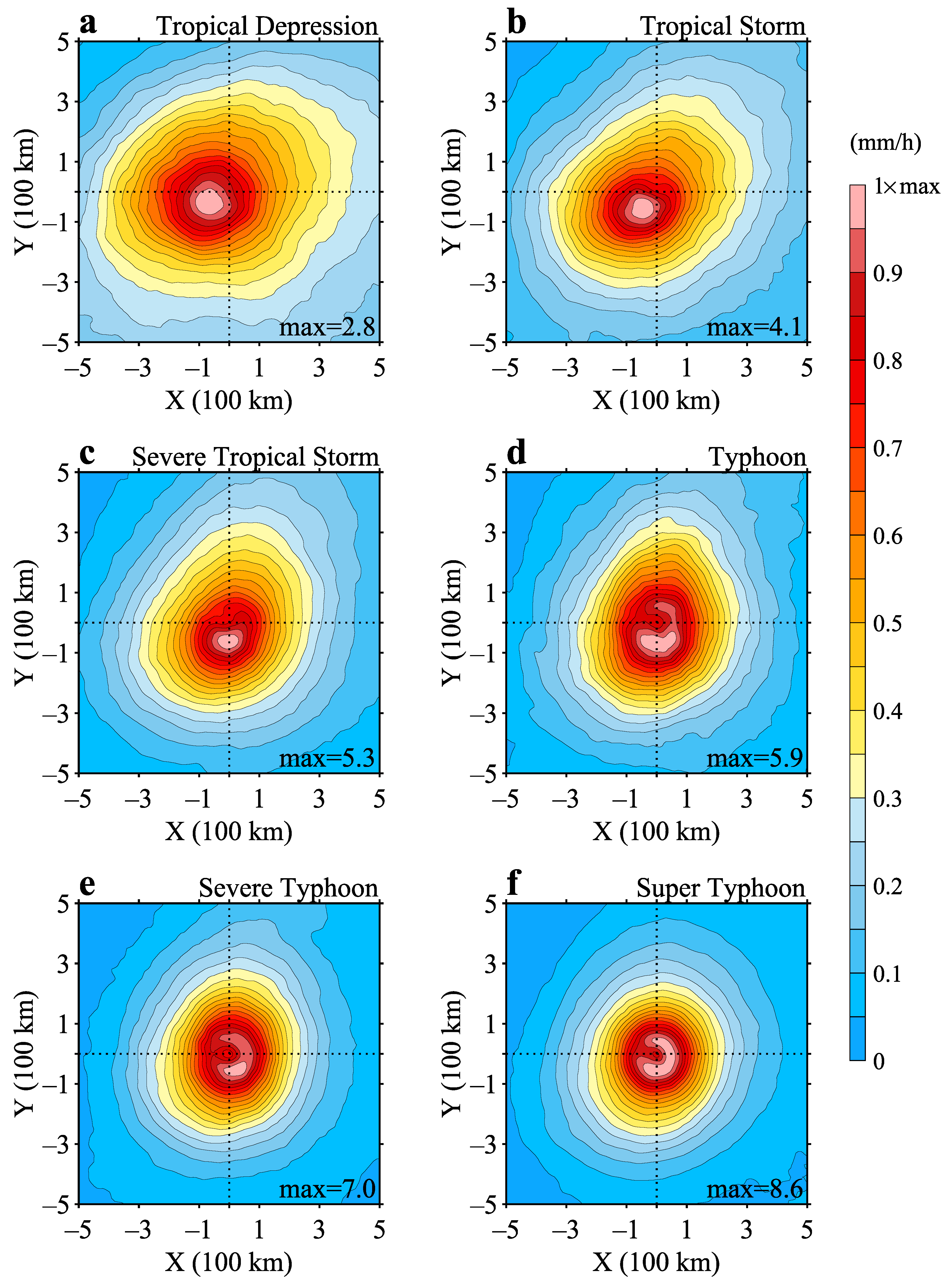
The averaged TC precipitation with respect to TC intensity levels is shown in Figure 5. As TC intensity increases from tropical depression to super typhoon, the magnitude of TC precipitation also increases, and the major precipitation area becomes more concentrated and symmetrical. For tropical depressions (Figure 5a) and tropical storms (Figure 5b), the maxima of average precipitation are observed in Quadrant III, within 100 km to the TC center. As the TCs intensify, the locations of maximum precipitation move in an anticlockwise direction. The maxima of precipitation are observed south of the TC center for severe tropical storms (Figure 5c) and typhoons (Figure 5d), and in Quadrant IV for severe and super typhoons (Figure 5e,f). The major precipitation areas narrow from approximately 400 km at tropical depressions to approximately 150 km at the super typhoon level. The southwest–northeast patterns of TC precipitation observed in weak TC intensities rotate anticlockwise direction as the TC intensities increase.
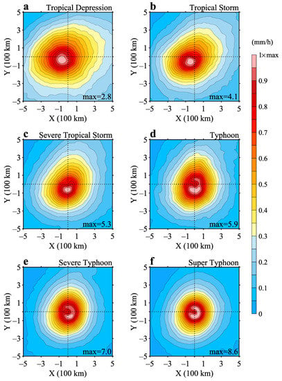
Figure 5.
Same as Figure 3 but relative to TC intensity levels: (a) tropical depression; (b) tropical storm; (c) severe tropical storm; (d) typhoon; (e) severe typhoon; (f) super typhoon.
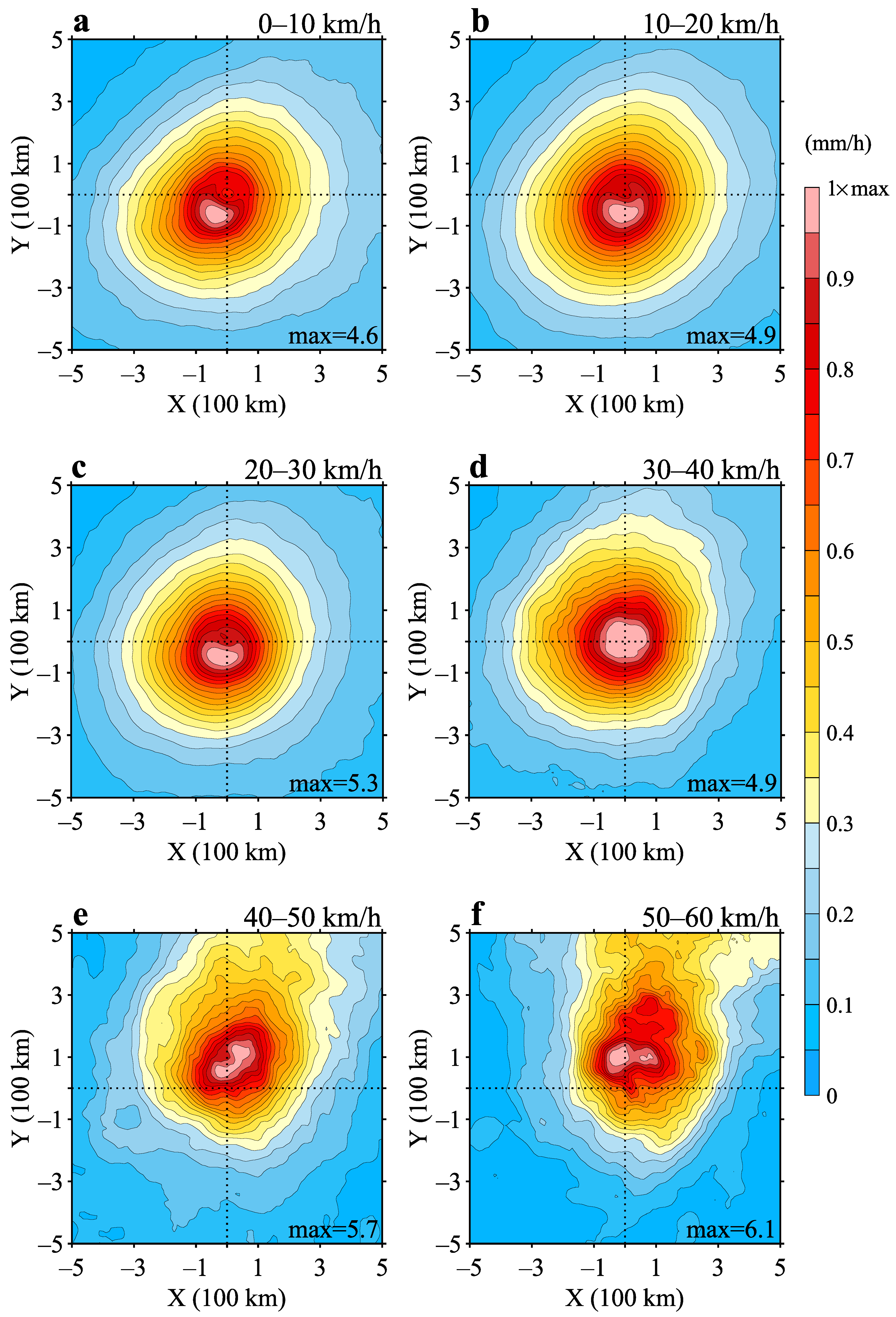
Figure 6 illustrates the spatial distribution of averaged TC precipitation relative to TC translation speeds. The results show that the maximum precipitation reaches 4.6, 4.9, 5.3, 4.9, 5.7, and 6.1 mm/h for TCs with 0–10 km/h, 10–20 km/h, 20–30 km/h, 30–40 km/h, 40–50 km/h, and 50–60 km/h, respectively. As translation speed increases, the precipitation becomes more asymmetric, particularly for TCs moving faster than 40 km/h (Figure 6e,f). The maximum precipitation shifts from Quadrant III for TCs with translation speeds below 30 km/h (Figure 6a–c) to Quadrant I for faster-moving TCs (Figure 6e,f). This shift is accompanied by a northeastward extension of more precipitation, resulting in more asymmetric structures of TC precipitation (Figure 6e,f). The equipluve of 30% maximum precipitation indicates that more precipitation is observed in outer areas beyond 300 km from the TC centers. As TC translation speed increases, there is a similar anticlockwise rotation of maximum precipitation. Overall, the results suggest that translation speed plays an important role in shaping the spatial distribution and intensity of TC precipitation.
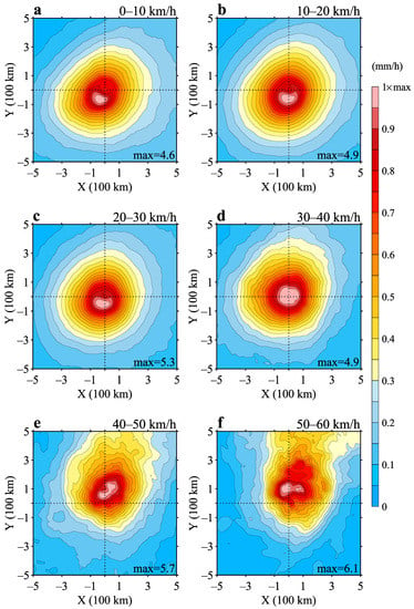
Figure 6.
Same as Figure 3 but relative to TC translation speeds. (a) 0–10 km/h; (b) 10–20 km/h; (c) 20–30 km/h; (d) 30–40 km/h; (e) 40–50 km/h; (f) 50–60 km/h.
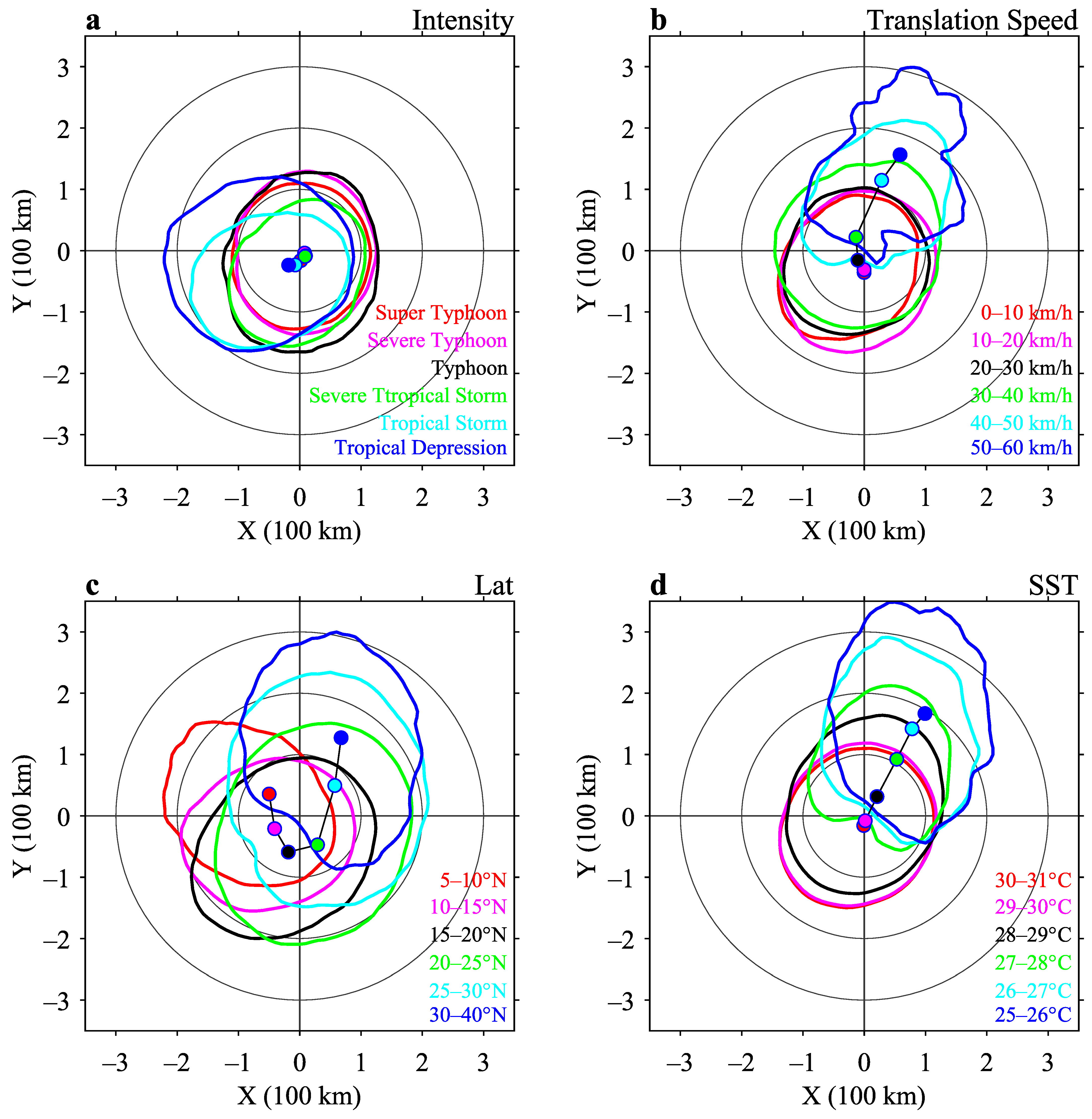
Figure 7 compares the spatial asymmetry in TC precipitation against varying variables, including TC intensity, translation speed, latitude, and SST at the TC center. The results show distinct sensitivities of precipitation asymmetry to these variables. For instance, TC precipitation is asymmetric in Quadrants II and III during tropical storm and below intensity levels but becomes quasi-symmetric as TC intensity increases (Figure 7a). The centroids of TC precipitations also suggested that with TC intensity increases, the precipitation concentrates to the TC center (Figure 7a). Moreover, the study shows that as TC translation speed exceeds 30 km/h, spatial asymmetry in TC precipitation grows rapidly, while the precipitation becomes quasi-symmetric for translation speeds below 30 km/h (Figure 7b). This spatial asymmetry is depicted in Figure 7b by the northeastward extension of TC precipitation into Quadrant I. These findings suggest that TC precipitation is asymmetric mainly in TCs with weak intensity and high translation speed, while it is quasi-symmetric in TCs with strong intensity and low translation speed.
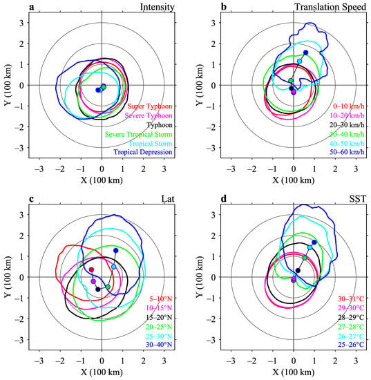
Figure 7.
Comparisons of spatial asymmetry in TC precipitation versus different parameters. (a) TC intensity; (b) TC translations speed; (c) latitude of TC center; (d) SST value at TC center. (contours denote the equipluves of 70% maximum precipitation in Figure 3, Figure 4, Figure 5 and Figure 6, dots denote the centroids of the precipitations in Figure 3, Figure 4, Figure 5 and Figure 6).
Figure 7c shows that the asymmetry in TC precipitation rotates anticlockwise from Quadrant IV to I during the poleward translation of TCs, indicating that the spatial asymmetry in TC precipitation exists throughout the NWP basin and is influenced by the TC intensity and movement states. Furthermore, Figure 7d illustrates that the asymmetry in TC precipitation increases quasi-linearly with increasing SST at the TC center. TC precipitation tends to concentrate at the TC center when the SST at the TC center is above 29 °C, where the TCs are typically located at lower latitudes and have strong intensities. As TCs move poleward, the SSTs at the TC centers decrease, leading to more asymmetric TC precipitation (Figure 7d).
3.3. Mechanism Analysis
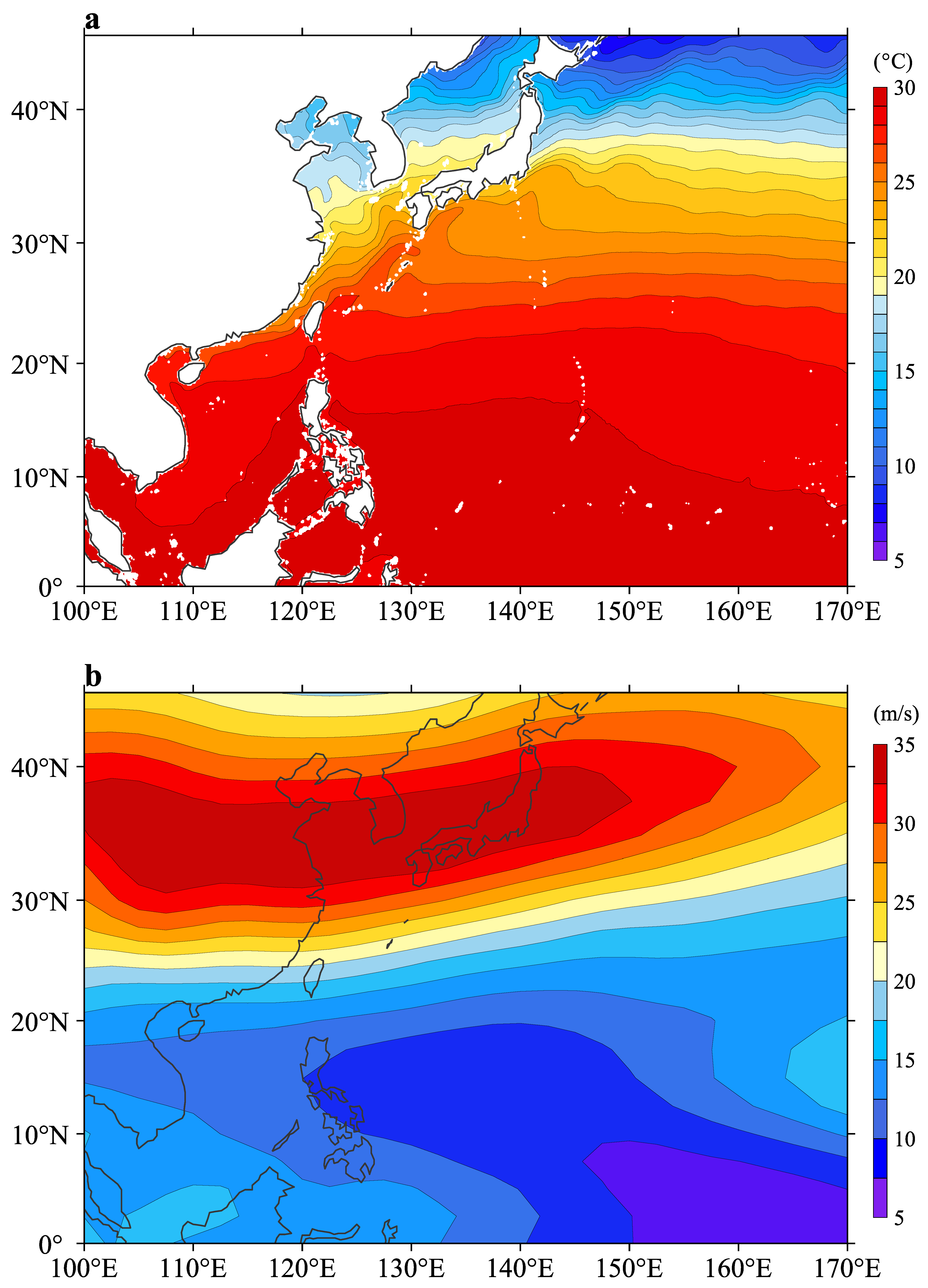
Figure 8 displays the climatological environmental conditions of SST and VWS averaged over TC seasons from 2003 to 2019. The results depict that background SST and VWS decreased and increase poleward, which is due to the poleward decreasing solar radiation and changes of atmospheric circulation [44,45]. In areas equatorward 15° N, SST (Figure 8a) and VWS (Figure 8b) are above 28 °C and below 15 m/s, respectively, both providing favorable conditions for TC development. These areas are the major regions where TCs intensify with relatively weak TC intensity, thus the average TC precipitation is Quadrant III asymmetric (Figure 2). As TCs move poleward to north of 20° N, SST decreases to below 28 °C and VWS increases to above 15 m/s. The poleward increase in VWS and decrease in SST conditions enhance TC asymmetric structures [24,29] and encourage prefrontal precipitation at the north. Thus, the poleward migration of SST and VWS are likely the important inducement of the Quadrant I asymmetric spatial patterns at high latitudes (Figure 2).
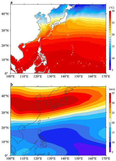
Figure 8.
Climatologic environment conditions during TC seasons from April to December averaged from 2003 to 2019. (a) SST; (b) VWS.
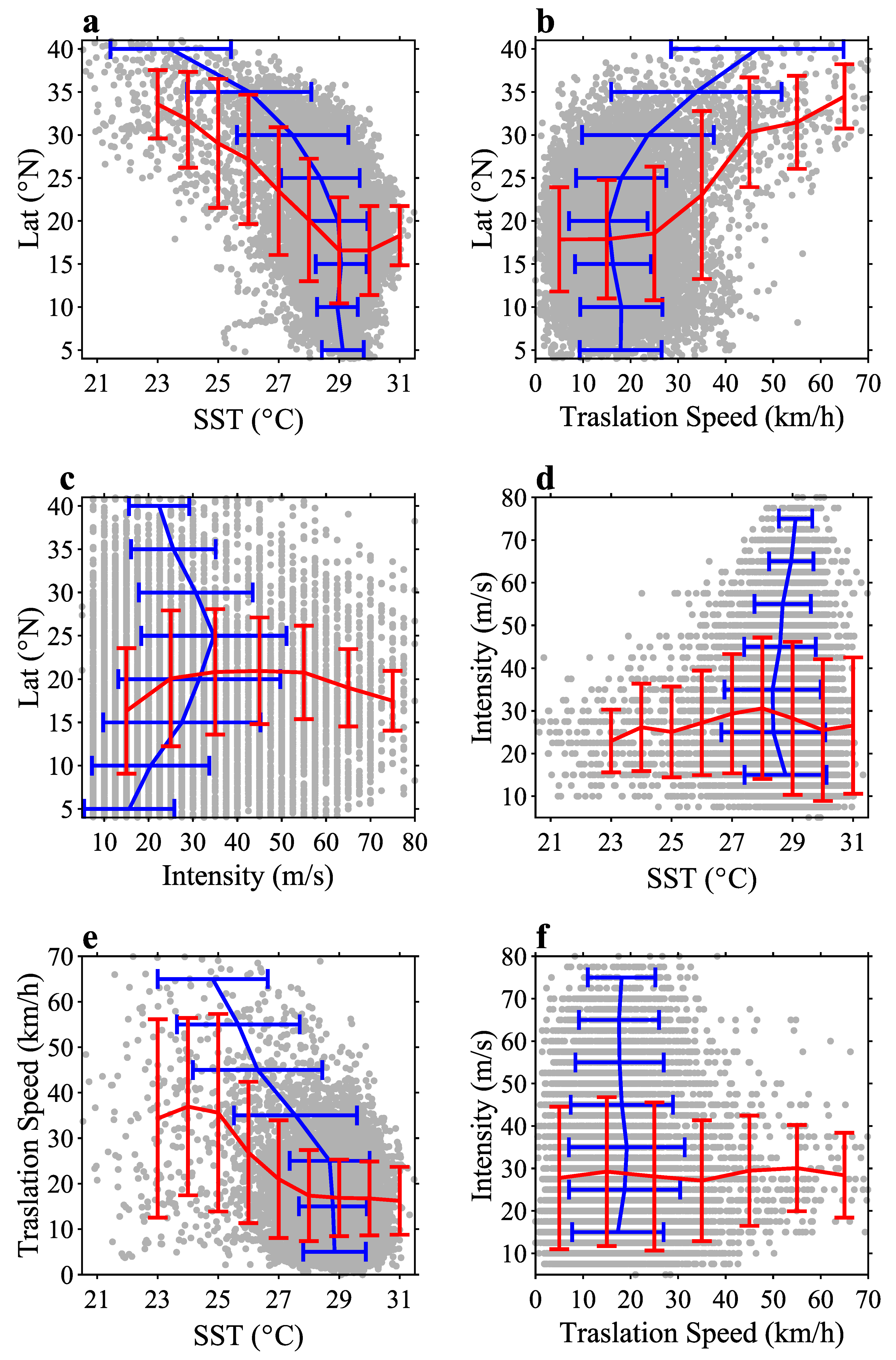
Considering the important role of TC translation speed and intensity in TC precipitation, Figure 9 further compares the relationships among the latitude and SST at the TC center, TC intensity, and translation speed of all TCs from 2003 to 2019. The results show that these variables exhibit quasi-linear relations as TCs with SST lower than 28 °C, higher latitudes poleward out of 15° N, and translation speed higher than 30 km/h (Figure 9a,b,d), which is consistent with the previous studies [46,47,48,49]. Notably, within these ranges, TC precipitation asymmetry gradually increases toward Quadrant I (Figure 7b–d). In contrast, TC intensity shows more complex relationships with TC center meridional position (Figure 9c), SST (Figure 9d), and translation speed (Figure 9f). Therefore, the spatial asymmetry in TC precipitation shows little sensitivity to TC intensity (Figure 7a). Thus, the environmental SST, VWS, and TC translation speed are the dominant factors in controlling the poleward migration of TC precipitation spatial asymmetry.
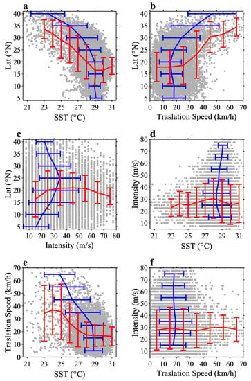
Figure 9.
Relations in the latitudes of TC center, SST at TC center, TC intensity, and translation speed (gray dots denote TC observations; red and blue lines denote the mean values with error plots along x-axis and y-axis, respectively). (a) Latitude versus SST; (b) Latitude versus SST versus translation speed; (c) Latitude versus TC intensity; (d) TC intensity versus SST; (e) TC translation speed versus SST; (f) TC intensity versus translation speed.
4. Discussion and Concluding Remarks
This study investigates the spatial asymmetry in TC precipitation over the WNP using satellite-observed precipitation data from 2003 to 2019. The results demonstrate that TC precipitation exhibits distinctly asymmetric patterns that change at varying locations over the WNP. By assembling TC precipitation relative to different TC parameters and environmental conditions, including TC center latitudes, intensity, translation speed, and SST at the TC center, spatial asymmetry in TC precipitation exhibits good agreement with these factors. Overall, the spatial asymmetry exhibits a significant poleward migration over the WNP, particularly as TCs at the north of 15° N, with colder SST below 29 °C, faster translation speed over 20 km/h. The poleward migration trend of the spatial asymmetry in TC precipitation is primarily attributed to the poleward decrease in SST and increase in TC translation speed and VWS as TCs moved towards higher latitudes.
The findings of this study have significant implications for regional atmospheric and oceanic thermodynamic processes, which also can be used to develop more accurate prediction models of TC precipitation. The results are consistent with the previous studies that faster TC translation speed and higher VWS increased TC spatial asymmetry [30,46,47,48,49]. In contrast to the previous studies which focus on TC rainfall area [28,29], the present study finds that the poleward decrease in SST plays a role in the poleward migration of TC precipitation spatial asymmetry. Future research can be conducted to investigate the relationship between TC precipitation and other environmental factors such as topography and atmospheric conditions, to gain a more comprehensive understanding of the spatial asymmetry in TC precipitation over the WNP.
The present study investigates the poleward migration of spatial asymmetry in TC precipitation in climatology, in which oceanic and atmospheric environmental conditions play crucial roles. Considering the significant responses of oceanic and atmospheric conditions to low-frequency variability (such as ENSO, summer monsoon, and IOD) and intraseasonal variability (such as boreal summer intraseasonal oscillation and tropical waves) [50,51,52,53,54], the spatial asymmetry in TC precipitation is likely to be greatly influenced by these factors. It is also noted that the poleward increasing TC translation speed is significantly influenced by steering flow over the WNP, on which the Pacific–Japan (PJ) teleconnection pattern has an important effect, especially at higher latitudes [55]. By influencing the weather and climate conditions over the WNP, PJ pattern is speculated to have negligible influences on the poleward migration of TC precipitation spatial asymmetry. Thus, planned future work includes further investigations on the relationships between TC precipitation spatial asymmetry and these factors.
In conclusion, this study has contributed to our understanding of the spatial asymmetry in TC precipitation over the WNP. The findings highlight the importance of considering various environmental factors when modeling and predicting TC precipitation. The results of this study can be applied to enhance disaster risk reduction measures, especially in regions that are highly vulnerable to the impacts of tropical cyclones.
Author Contributions
Conceptualization, X.J. and J.S.; methodology, X.J., J.S. and X.H.; software, X.J. and L.L.; validation, J.S., X.X. and D.W.; formal analysis, X.J., J.S. and X.H.; investigation, L.L., Z.R., Y.G., L.Y. and Z.H.; resources, X.X.; data curation, J.S., L.L. and D.W.; writing—original draft preparation, X.J.; writing—review and editing, J.S.; visualization, X.J. and J.S.; supervision, X.X.; project administration, J.S. and X.X.; funding acquisition, J.S. All authors have read and agreed to the published version of the manuscript.
Funding
This research was funded by the Basic Scientific Fund for National Public Research Institutes of China, grant number 2020Q05, the Shandong Provincial Natural Science Foundation, grant number ZR2022MD020 and the National Natural Science Foundation of China, grant numbers 41706034 and 41506034, the National Key Research and Development Program of China, grant number 2020YFA0607900.
Institutional Review Board Statement
Not applicable.
Informed Consent Statement
Not applicable.
Data Availability Statement
The data that support the findings of this study are publicly available and can be obtained from the following sources: IBTrACS made by NOAA/NCDC (https://www.ncei.noaa.gov/products/international-best-track-archive, accessed on 31 January 2023), SST data from RSS (https://www.remss.com/measurements/sea-surface-temperature/, accessed on 28 January 2023), TRMM rainfall dataset pro-vided by NASA (https://disc.gsfc.nasa.gov/datasets/TRMM_3B42_Daily_7/summary?keywords=TRMM_3B42_Daily_7, accessed on 28 January 2023), and wind data reanalyzed by NCEP/NCAR (https://psl.noaa.gov/data/gridded/data.ncep.reanalysis.html, accessed on 31 January 2023).
Acknowledgments
The authors acknowledge JTWC, RSS, NASA and NCEP/NCAR for the provision of the datasets used herein.
Conflicts of Interest
The authors declare no conflict of interest.
References
- Parks, R.M.; Anderson, G.B.; Nethery, R.C.; Navas-Acien, A.; Dominici, F.; Kioumourtzoglou, M.A. Tropical cyclone exposure is associated with increased hospitalization rates in older adults. Nat. Commun. 2021, 12, 1545. [Google Scholar] [CrossRef]
- Parks, R.M.; Benavides, J.; Anderson, G.B.; Nethery, R.C.; Navas-Acien, A.; Dominici, F.; Ezzati, M.; Kioumourtzoglou, M.A. Association of Tropical Cyclones with County-Level Mortality in the US. JAMA 2022, 327, 946–955. [Google Scholar] [CrossRef]
- Czajkowski, J.; Villarini, G.; Montgomery, M.; Michel-Kerjan, E.; Goska, R. Assessing Current and Future Freshwater Flood Risk from North Atlantic Tropical Cyclones via Insurance Claims. Sci. Rep. 2017, 7, 41609. [Google Scholar] [CrossRef]
- Samodra, G.; Ngadisih, N.; Malawani, M.N.; Mardiatno, D.; Cahyadi, A.; Nugroho, F.S. Frequency–magnitude of landslides affected by the 27–29 November 2017 Tropical Cyclone Cempaka in Pacitan, East Java. J. Mt. Sci. 2020, 17, 773–786. [Google Scholar] [CrossRef]
- Zhang, H.; Hu, S.; Cheng, W.; Zhu, L.; Chen, Y.; Liu, J.; Gong, W.; Li, Y.; Li, S. Response of freshwater transport during typhoons with wave-induced mixing effects in the Pearl River Estuary, China. Estuar. Coast. Shelf Sci. 2021, 258, 107439. [Google Scholar] [CrossRef]
- Kossin, J.P.; Olander, T.L.; Knapp, K.R. Trend Analysis with a New Global Record of Tropical Cyclone Intensity. J. Clim. 2013, 26, 9960–9976. [Google Scholar] [CrossRef]
- Niu, Y.; Touma, D.; Ting, M.; Camargo, S.J.; Chen, R. Assessing Heavy Precipitation Risk Associated with Tropical Cyclones in China. J. Appl. Meteorol. Climatol. 2022, 61, 577–591. [Google Scholar] [CrossRef]
- Liang, J.; Chan, K.T.F. Rainfall asymmetries of the western North Pacific tropical cyclones as inferred from GPM. Int. J. Climatol. 2021, 41, 5465–5480. [Google Scholar] [CrossRef]
- Liu, H.; Gu, J.; Wang, Y. Consistent Pattern of Rainfall Asymmetry in Binary Tropical Cyclones. Geophys. Res. Lett. 2023, 50, e2022GL101866. [Google Scholar] [CrossRef]
- Pei, Y.; Jiang, H. Quantification of Precipitation Asymmetries of Tropical Cyclones Using 16-Year TRMM Observations. J. Geophys. Res. Atmos. 2018, 123, 8091–8114. [Google Scholar] [CrossRef]
- Hu, Y.; Zou, X. Determining Tropical Cyclone Center and Rainband Size in Geostationary Satellite Imagery. Remote Sens. 2022, 14, 3499. [Google Scholar] [CrossRef]
- Touma, D.; Stevenson, S.; Camargo, S.J.; Horton, D.E.; Diffenbaugh, N.S. Variations in the Intensity and Spatial Extent of Tropical Cyclone Precipitation. Geophys. Res. Lett. 2019, 46, 13992–14002. [Google Scholar] [CrossRef]
- Wingo, M.T.; Cecil, D.J. Effects of Vertical Wind Shear on Tropical Cyclone Precipitation. Mon. Weather Rev. 2010, 138, 645–662. [Google Scholar] [CrossRef]
- Li, Q.; Wang, Y.; Duan, Y. A Numerical Study of Outer Rainband Formation in a Sheared Tropical Cyclone. J. Atmos. Sci. 2017, 74, 203–227. [Google Scholar] [CrossRef]
- Na, W.; Xinghai, Z.; Lianshou, C.; Hao, H. Comparison of the effect of easterly and westerly vertical wind shear on tropical cyclone intensity change over the western North Pacific. Environ. Res. Lett. 2018, 13, 034020. [Google Scholar] [CrossRef]
- Uddin, M.J.; Nasrin, Z.M.; Li, Y. Effects of vertical wind shear and storm motion on tropical cyclone rainfall asymmetries over the North Indian Ocean. Dyn. Atmos. Ocean. 2021, 93, 101196. [Google Scholar] [CrossRef]
- Good, P.; Chadwick, R.; Holloway, C.E.; Kennedy, J.; Lowe, J.A.; Roehrig, R.; Rushley, S.S. High sensitivity of tropical precipitation to local sea surface temperature. Nature 2021, 589, 408–414. [Google Scholar] [CrossRef]
- Stansfield, A.M.; Reed, K.A. Tropical Cyclone Precipitation Response to Surface Warming in Aquaplanet Simulations with Uniform Thermal Forcing. J. Geophys. Res. Atmos. 2021, 126, e2021JD035197. [Google Scholar] [CrossRef]
- Hallam, S.; McCarthy, G.D.; Feng, X.; Josey, S.A.; Harris, E.; Düsterhus, A.; Ogungbenro, S.; Hirschi, J.J.M. The relationship between sea surface temperature anomalies, wind and translation speed and North Atlantic tropical cyclone rainfall over ocean and land. Environ. Res. Commun. 2023, 5, 025007. [Google Scholar] [CrossRef]
- Finocchio, P.M.; Rios-Berrios, R. The Intensity- and Size-Dependent Response of Tropical Cyclones to Increasing Vertical Wind Shear. J. Atmos. Sci. 2021, 78, 3673–3690. [Google Scholar] [CrossRef]
- Fu, H.; Wang, Y.; Riemer, M.; Li, Q. Effect of Unidirectional Vertical Wind Shear on Tropical Cyclone Intensity Change—Lower-Layer Shear versus Upper-Layer Shear. J. Geophys. Res. Atmos. 2019, 124, 6265–6282. [Google Scholar] [CrossRef]
- Zhang, F.; Tao, D. Evolution of Dynamic and Thermodynamic Structures before and during Rapid Intensification of Tropical Cyclones: Sensitivity to Vertical Wind Shear. Mon. Weather Rev. 2019, 147, 1171–1191. [Google Scholar] [CrossRef]
- Knutson, T.R.; McBride, J.L.; Chan, J.; Emanuel, K.; Holland, G.; Landsea, C.; Held, I.; Kossin, J.P.; Srivastava, A.K.; Sugi, M. Tropical cyclones and climate change. Nat. Geosci. 2010, 3, 157–163. [Google Scholar] [CrossRef]
- Sun, J.; Ju, X.; Zheng, Q.; Wang, G.; Li, L.; Xiong, X. Numerical Study of the Response of Typhoon Hato (2017) to Grouped Mesoscale Eddies in the Northern South China Sea. J. Geophys. Res. Atmos. 2023, 128, e2022JD037266. [Google Scholar] [CrossRef]
- Sun, J.; Wang, G.; Jin, S.; Ju, X.; Xiong, X. Quantifying tropical cyclone intensity change induced by sea surface temperature. Int. J. Climatol. 2022, 42, 4716–4727. [Google Scholar] [CrossRef]
- Sun, J.; Wang, G.; Xiong, X.; Hui, Z.; Hu, X.; Ling, Z.; Yu, L.; Yang, G.; Guo, Y.; Ju, X.; et al. Impact of warm mesoscale eddy on tropical cyclone intensity. Acta Oceanol. Sin. 2020, 39, 1–13. [Google Scholar] [CrossRef]
- Sun, J.; Zuo, J.; Ling, Z.; Yan, Y. Role of ocean upper layer warm water in the rapid intensification of tropical cyclones: A case study of typhoon Rammasun (1409). Acta Oceanol. Sin. 2016, 35, 63–68. [Google Scholar] [CrossRef]
- Lin, Y.; Zhao, M.; Zhang, M. Tropical cyclone rainfall area controlled by relative sea surface temperature. Nat. Commun. 2015, 6, 6591. [Google Scholar] [CrossRef]
- Kim, D.; Ho, C.-H.; Park, D.-S.R.; Chan, J.C.L.; Jung, Y. The Relationship between Tropical Cyclone Rainfall Area and Environmental Conditions over the Subtropical Oceans. J. Clim. 2018, 31, 4605–4616. [Google Scholar] [CrossRef]
- Tu, S.; Chan, J.C.L.; Xu, J.; Zhong, Q.; Zhou, W.; Zhang, Y. Increase in tropical cyclone rain rate with translation speed. Nat. Commun. 2022, 13, 7325. [Google Scholar] [CrossRef]
- Sun, J.; Wang, D.; Hu, X.; Ling, Z.; Wang, L. Ongoing Poleward Migration of Tropical Cyclone Occurrence Over the Western North Pacific Ocean. Geophys. Res. Lett. 2019, 46, 9110–9117. [Google Scholar] [CrossRef]
- Wu, L.; Wang, B.; Geng, S. Growing typhoon influence on east Asia. Geophys. Res. Lett. 2005, 32, L18703. [Google Scholar] [CrossRef]
- Zhang, L.; Karnauskas, K.B.; Donnelly, J.P.; Emanuel, K. Response of the North Pacific Tropical Cyclone Climatology to Global Warming: Application of Dynamical Downscaling to CMIP5 Models. J. Clim. 2017, 30, 1233–1243. [Google Scholar] [CrossRef]
- Feng, X.; Klingaman, N.P.; Hodges, K.I. Poleward migration of western North Pacific tropical cyclones related to changes in cyclone seasonality. Nat. Commun. 2021, 12, 6210. [Google Scholar] [CrossRef] [PubMed]
- Sun, J.; Wang, G.; Zuo, J.; Ling, Z.; Liu, D. Role of surface warming in the northward shift of tropical cyclone tracks over the South China Sea in November. Acta Oceanol. Sin. 2017, 36, 67–72. [Google Scholar] [CrossRef]
- Knapp, K.R.; Diamond, H.J.; Kossin, J.P.; Kruk, M.C.; Schreck, C.J. International Best Track Archive for Climate Stewardship (IBTrACS) Project (Version 4) [Dataset]; NOAA National Centers for Environmental Information: Stennis Space Center, MS, USA, 2018. [CrossRef]
- Knapp, K.R.; Kruk, M.C.; Levinson, D.H.; Diamond, H.J.; Neumann, C.J. The International Best Track Archive for Climate Stewardship (IBTrACS). Bull. Am. Meteorol. Soc. 2010, 91, 363–376. [Google Scholar] [CrossRef]
- MW-IR Optimum Interpolated SST Dataset Version 5.1. Remote Sensing Systems (RSS) [Dataset]; PO.DAAC: Pasadena, CA, USA, 2022. [CrossRef]
- Dare, R.A.; McBride, J.L. Sea Surface Temperature Response to Tropical Cyclones. Mon. Weather Rev. 2011, 139, 3798–3808. [Google Scholar] [CrossRef]
- Vincent, E.M.; Lengaigne, M.; Madec, G.; Vialard, J.; Samson, G.; Jourdain, N.C.; Menkes, C.E.; Jullien, S. Processes setting the characteristics of sea surface cooling induced by tropical cyclones. J. Geophys. Res. Ocean. 2012, 117, C02020. [Google Scholar] [CrossRef]
- Wang, S.; Toumi, R. Recent tropical cyclone changes inferred from ocean surface temperature cold wakes. Sci. Rep. 2021, 11, 22269. [Google Scholar] [CrossRef]
- Huffman, G.J.; Bolvin, D.T.; Nelkin, E.J.; Adler, R.F. TRMM (TMPA) Precipitation L3 1 Day 0.25 Degree x 0.25 Degree V7; [Dataset]; Savtchenko, A., Ed.; Goddard Earth Sciences Data and Information Services Center (GES DISC): Greenbelt, MD, USA, 2016. [CrossRef]
- Kalnay, E.; Kanamitsu, M.; Kistler, R.; Collins, W.; Deaven, D.; Gandin, L.; Iredell, M.; Saha, S.; White, G.; Woollen, J.; et al. The NCEP/NCAR 40-Year Reanalysis Project. Bull. Am. Meteorol. Soc. 1996, 77, 437–471. [Google Scholar] [CrossRef]
- Deser, C.; Alexander, M.A.; Xie, S.P.; Phillips, A.S. Sea surface temperature variability: Patterns and mechanisms. Annu. Rev. Mar. Sci. 2010, 2, 115–143. [Google Scholar] [CrossRef] [PubMed]
- Merchant, C.J.; Minnett, P.J.; Beggs, H.; Corlett, G.K.; Gentemann, C.; Harris, A.R.; Hoyer, J.; Maturi, E. Global Sea Surface Temperature. In Taking the Temperature of the Earth; Hulley, G.C., Ghent, D., Eds.; Elsevier: Amsterdam, The Netherlands, 2019; pp. 5–55. [Google Scholar]
- Chen, S.S.; Knaff, J.A.; Marks, F.D. Effects of Vertical Wind Shear and Storm Motion on Tropical Cyclone Rainfall Asymmetries Deduced from TRMM. Mon. Weather Rev. 2006, 134, 3190–3208. [Google Scholar] [CrossRef]
- Yamaguchi, M.; Chan, J.C.L.; Moon, I.J.; Yoshida, K.; Mizuta, R. Global warming changes tropical cyclone translation speed. Nat. Commun. 2020, 11, 47. [Google Scholar] [CrossRef]
- Zhang, D.; Zhang, H.; Zheng, J.; Cheng, X.; Tian, D.; Chen, D. Changes in Tropical-Cyclone Translation Speed over the Western North Pacific. Atmosphere 2020, 11, 93. [Google Scholar] [CrossRef]
- Zhang, G.; Murakami, H.; Knutson, T.R.; Mizuta, R.; Yoshida, K. Tropical cyclone motion in a changing climate. Sci. Adv. 2020, 6, eaaz7610. [Google Scholar] [CrossRef]
- Lee, S.-S.; Moon, J.-Y.; Wang, B.; Kim, H.-J. Subseasonal Prediction of Extreme Precipitation over Asia: Boreal Summer Intraseasonal Oscillation Perspective. J. Clim. 2017, 30, 2849–2865. [Google Scholar] [CrossRef]
- Lubis, S.W.; Jacobi, C. The modulating influence of convectively coupled equatorial waves (CCEWs) on the variability of tropical precipitation. Int. J. Climatol. 2015, 35, 1465–1483. [Google Scholar] [CrossRef]
- Muhammad, F.R.; Lubis, S.W. Impacts of the boreal summer intraseasonal oscillation on precipitation extremes in Indonesia. Int. J. Climatol. 2022, 43, 1576–1592. [Google Scholar] [CrossRef]
- Ren, P.; Ren, H.L.; Fu, J.X.; Wu, J.; Du, L. Impact of Boreal Summer Intraseasonal Oscillation on Rainfall Extremes in Southeastern China and its Predictability in CFSv2. J. Geophys. Res. Atmos. 2018, 123, 4423–4442. [Google Scholar] [CrossRef]
- Schreck, C.J.; Molinari, J.; Mohr, K.I. Attributing Tropical Cyclogenesis to Equatorial Waves in the Western North Pacific. J. Atmos. Sci. 2011, 68, 195–209. [Google Scholar] [CrossRef]
- Kubota, H.; Kosaka, Y.; Xie, S. A 117-year long index of the Pacific-Japan pattern with application to interdecadal variability. Int. J. Climatol. 2015, 36, 1575–1589. [Google Scholar] [CrossRef]
Disclaimer/Publisher’s Note: The statements, opinions and data contained in all publications are solely those of the individual author(s) and contributor(s) and not of MDPI and/or the editor(s). MDPI and/or the editor(s) disclaim responsibility for any injury to people or property resulting from any ideas, methods, instructions or products referred to in the content. |
© 2023 by the authors. Licensee MDPI, Basel, Switzerland. This article is an open access article distributed under the terms and conditions of the Creative Commons Attribution (CC BY) license (https://creativecommons.org/licenses/by/4.0/).

