Article

Critical Pre-Formation Decision Flowchart to Apply Tropical Cyclone Lifecycle Predictions in Eastern North Pacific

1
Lyda Hill Institute for Human Resilience, University of Colorado-Colorado Springs, Colorado Springs, CO 80918, USA
2
Department of Meteorology, Naval Postgraduate School, Monterey, CA 93943, USA
3
Department of Water Resources and Environmental Engineering, Tamkang University, New Taipei City 251301, Taiwan
4
NOAA Geophysical Fluid Dynamics Laboratory, Princeton, NJ 08540, USA
*
Authors to whom correspondence should be addressed.
Atmosphere 2023, 14(4), 616; https://doi.org/10.3390/atmos14040616
Submission received: 7 February 2023 / Revised: 20 March 2023 / Accepted: 22 March 2023 / Published: 24 March 2023

Abstract

:
We have previously demonstrated that the ECMWF ensemble (ECEPS) provides early forecasts not only of the Time-to-Tropical Storm (T2TS) and of the Time-to-Hurricane (T2HU), but also of the Time-Ending-Hurricane (TEHU) and Time-Ending-Tropical Storm (TETS) times and positions along those 15-day ECEPS track forecasts, which then provides an opportunity for high-wind warnings along the path during the entire lifecycle of these Hurricanes. The focus in this study is the Decision Flowchart that has been developed to assist the forecasters to select the pre-formation disturbance that is most likely to become the next Tropical Storm with the potential to become a Hurricane. The most crucial decision is to detect and eliminate any disturbance that likely originated from a precursor Caribbean false alarm circulation. Summaries of other steps in the Decision Flowchart “To Watch”, or to reject, other storm options in the twice-daily ECEPS forecasts are provided for Hurricanes Enrique and Felicia, and for strong Tropical Storm Guillermo and weak Tropical Storm Jimena. The first detections in the ECEPS forecasts for the Tropical Storms during the 2021 season averaged 6 days, 18 h in advance with a range of only 2 days, 6 h in advance for TS Terry to 9 days, 18 h in advance for TS Sandra.

1. Introduction

Elsberry et al. (2022) [1] have extended previous studies of western North Pacific tropical cyclone (TC) formation and intensity predictions along the 15-day ECMWF ensemble track forecasts to the eastern North Pacific (ENP) during the 2021 Hurricane season. The first objective was simply to provide earlier forecasts of the T2TS and the T2HU than are available from the National Hurricane Center (NHC) Advisories. The NHC Tropical Weather Outlooks (TWO) provide early probabilistic genesis guidance at 48 h and at 120 h within elliptical areas oriented along the anticipated path. However, it is not until the first six-hourly Advisory is issued that the NHC provides a specific forecast of the timing and position of that genesis and a 5-day track and intensity forecast. As indicated by Elsberry et al. [1] Table 1, the initial intensities were already at Tropical Storm intensity in the first Advisories for three of the eight ENP Hurricanes during the 2021 season, and the first Advisory intensities were 30 kt for the other five ENP Hurricanes. Since all of these eight ENP Hurricanes had a T2HU within the 5-day intensity forecast in their first Advisories, the objective of Elsberry et al. [1] was to also provide earlier T2HU guidance than in those first NHC Advisories.
As Elsberry et al. [1] document in their Table 5, their technique utilizing the ECMWF ensemble (ECEPS) forecasts had first detections of the first six ENP Hurricanes that ranged from 8 days to 12 days in advance of their T2TS times, and from 9 days to 13 days in advance of their T2HU times. For the Hurricanes Pamela and Rick that made landfall within a few days after becoming a Hurricane, the first detections were about 6 days in advance of the T2TS times and about 7 days in advance of the T2HU. While the TC warning centers may not want to issue 12 days in advance alerts or warnings to the general public, good situational awareness of such Hurricane threats may be appropriate for the Department of Defense and other maritime interests, reservoir management agencies, and disaster preparedness groups in advance of landfall.
The major advance of the Elsberry et al. [1] study was the documentation of the fact that the ECEPS was also able to predict the TEHU and TETS times and positions along these 15-day ECEPS Weighted Mean Vector Motion (WMVM) track forecasts. It is important to note that in the WMVM calculation, the largest (smallest) weight is given to the ensemble member motion vector that is closest to (farthest from) the most recent 12-h WMVM vector. Those same Elsberry et al. [1] track weighting factors are utilized to give the largest weight in the weighted-mean Warm Core Magnitude (WCM) calculation along that WMVM track forecast. Elsberry et al. [1] had found that the appropriate ECEPS-predicted WCM threshold values for the ENP storm intensities were: Maximum WCM < 25.0 (or 20.0 if weak) for Tropical Depression; 25.0 < WCM < 37.0 for Tropical Storm, and WCM > 37.0 for Hurricane.
The major discovery that these WCM thresholds that had been derived for the pre-formation ECEPS predictions of the WCM to forecast the T2TS and T2HU timings and positions could also be used to forecast first the TEHU and then the TETS came in the pre-Hurricane Linda forecasts. A summary diagram is provided in Figure 1 for both the pre-formation and the Ending-Hurricane Linda and the Ending-TS Linda track forecasts (panel b, and a, respectively) and the timing errors for these two variables (panels c and d, respectively). Whereas the first NHC Advisory forecast of pre-TS Linda was only 12 h before the T2TS indicated in panel b, 19 ECEPS forecasts at 12-h intervals were available prior to that T2TS timing. Although there is substantial track spread due to the variations in the initial positions, the cross-track spread among these ECEPS forecasts that included both the TEHU and a TETS, the track spread was reasonable considering that these forecasts started as early as 14 days before the TEHU (panel b). The very small timing errors for the T2TS and the T2HU along these pre-TS tracks in panel (b) are presented in panel (c). However, the TEHU and TETS timing errors in panel (d) were consistently 1–2 days late after 00 UTC 12 August.
A critical forecast parameter that will trigger massive disaster preparedness activities in the Hawaiian Islands is whether the TC will cross 140° W at Hurricane intensity. It is also important to predict whether at least TS-force winds will impact the Islands. Elsberry et al. [1] documented that even some pre-formation ECEPS forecast had WMVM tracks that within the 15-day forecast would threaten Hawaii, and while crossing 140° W would likely have Hurricane-force winds. Consequently, Elsberry et al. [1] designated this advancement as an example of the ECEPS being capable of providing high wind warnings during the entire lifecycle of Hurricane Linda.
While Elsberry et al. [1] documented the success of the ECEPS in predicting the actual pre-TC circulation T2TS, T2HU, TEHU, and TETS as in Figure 1, the focus in this study is assisting the forecasts in identifying the false storm options. It is obvious that if the pre-formation ECEPS WMVM track and the ECEPS-predicted WCM evolution utilized in the T2TS and T2HU forecasts are not accurate, then the early ECEPS lifecycle predictions advocated by Elsberry et al. [1] will not be possible. In both the western North Pacific (e.g., Elsberry et al. 2021 [2] and Tsai et al. 2020 [3]) and in ENP [1], these early ECEPS pre-formation forecasts may have substantial uncertainty in the initial positions, track directions and speeds, and in the model initial conditions that affect the WCM evolutions. Consequently, the 51-member ECEPS has a tendency to predict five or more ensemble storm options with different intensity evolutions in addition to the actual pre-TC circulation that is highly likely to become a TS and a Hurricane. As indicated by Elsberry et al. [1], a crucial factor in the success of pre-formation forecasts in the ENP is to detect precursor circulations that form in the southern Caribbean Sea and falsely lead to TC formations after passing across Central America.
The overall objective of this study is to develop a systematic scenario-based approach for interpreting and applying the ECEPS forecasts to provide that early lifecycle guidance as to the T2TS and T2HU, and then the TEHU and TETS as well. Although the focus is on the ENP Hurricanes during the 2021 ENP season, the pre-Tropical Storms will also be evaluated because it is important to forecast almost-Hurricanes versus weak TSs. Furthermore, one non-developer is evaluated to demonstrate that the ECEPS-predicted WCM can also provide guidance that a long-lived pre-TC circulation will not become a TS. A decision flowchart has been developed to assist the forecasters in applying the technique to the twice-daily ECEPS forecasts, and thereby in combination with other forecast tools make a decision before issuance of alerts, advisories, or warnings.
The methodology will be described in Section 2, including the datasets and operating procedures. The main emphasis will be on the detection and elimination of the Caribbean false alarm (FA) precursor circulations leading to ENP TC formations. Since those Caribbean FAs and the opportunity for the TEHU and TETS forecasts were discovered during the 2021 season, a post-season reprocessing was required. The decision flowchart for selecting the most likely next Tropical Storm, and for either delaying the decision or eliminating a storm option, will be described in Section 3. In Section 4, the evaluations leading to the pre-formation selections of Hurricane Enrique and Hurricane Felicia, which were discussed in detail by Elsberry et al. [1], will be described as examples of the application of the decision flowchart for ENP Hurricanes. A similar evaluation of what Elsberry et al. [1] describe as “Almost-Hurricane Guillermo” will be presented to illustrate that the Decision Flowchart is also applicable to a strong TS as well. In addition, a weak Tropical Storm and a non-developer circulation will be briefly described in Section 4. A summary and discussion will be provided in Section 5.

2. Methodology

In this Office of Naval Research project to transition the western North Pacific formation guidance product to the eastern North Pacific, a near-real time demonstration of the ECEPS WMVM track forecasts and the TETS and the T2HU was planned. Capalbo (2022) [4] describes the data flow from the ECMWF to the NOAA Geophysical Fluid Dynamics Laboratory where the Marchok vortex tracker [5] is applied to the control and 50 other ECEPS ensemble member forecasts. For this study, the WMVM ensemble storm track forecasts, and the weighted-mean WCM evolutions along those WMVW track forecasts, were prepared by Professor Tsai’s team at Tamkang University in Taiwan and then the near–real time (~12 h) evaluations were done by Professor Elsberry and by Capt (us A Force) Capalbo throughout the 2021 season. While some efficiency could be achieved by performing the WMVW and WCM calculations and evaluations at the TC warning center, a time lapse of 12 h is not that critical when pre-TC disturbances are being detected five days or more in advance of the T2TS.
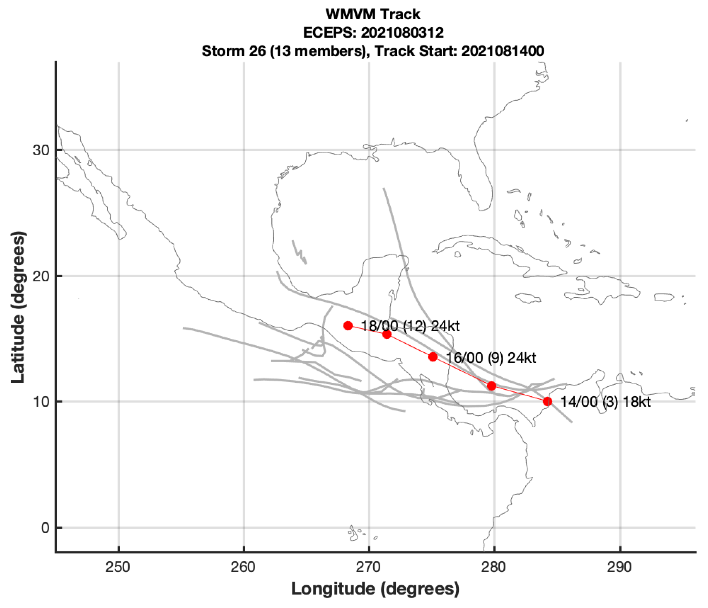
An example of such a sequence of these false alarm ensemble storms is illustrated in Figure 2 and Figure 3. Note in the 12 UTC 3 August ECEPS forecast Storm 26 had a maximum of 13 members of which 10 member tracks were in the ENP with some very diverse tracks. The WMVM track (red dots) originated at 00 UTC 14 August with three members in the southern Caribbean Sea and these original three members caused the WMVM track forecast to move northwestward and make landfall in Central America on 16 August, although one ensemble storm continued northward into the central Gulf of Mexico. Because the weighted-mean WCM was calculated along that landfalling WMVM track, with the largest (smallest) weight given to those ensemble members with the closest (farthest) 12-h vector motions aligned with the past 12-h motion vector, the Likely Storm Category (LSC) for Storm 26 in the 12 UTC 3 August ECEPS forecast was only a Tropical Depression (not shown).
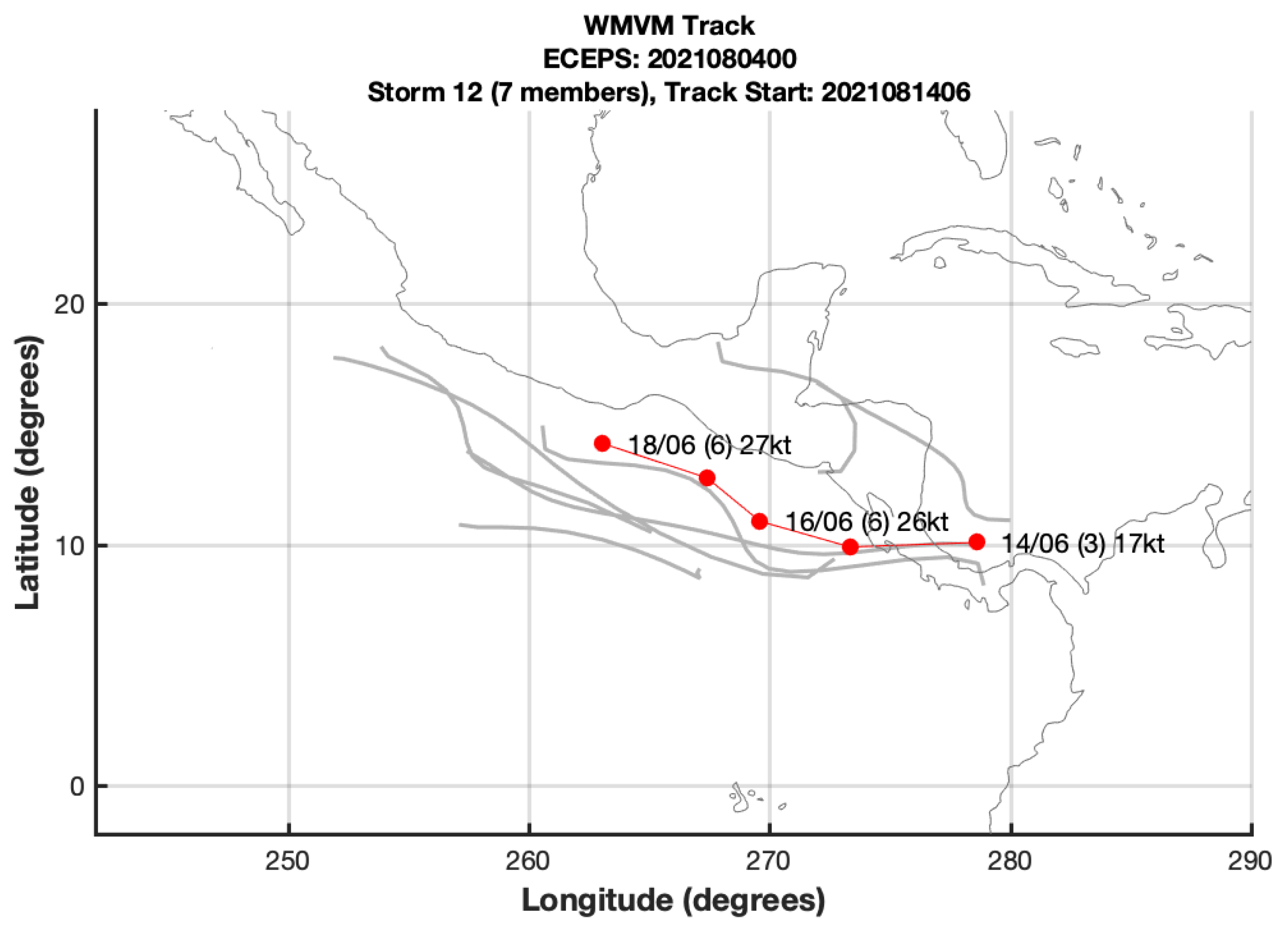
Just 12 h later (Figure 3), the 00 UTC 4 August ECEPS forecast Storm 12 started in the extreme southern Caribbean Sea with only one ensemble member track that moved northwestward along the previous WMVM track forecast. Two of the three initial WMVM ensemble member tracks were across the Central American peninsula into the ENP where the other ensemble member tracks joined. Although the ECEPS-predicted WCM evolution did not indicate even a Tropical Depression (TD) until four days later, the ECEPS weighted-mean vortex intensity predicted a TD-stage within 24 h after movement into the ENP (not shown).
Such Caribbean ensemble storm tracks were one of the four categories of Atlantic TC events (formation plus track) studied by Elsberry et al. (2014) [6]. Notably, not a single southern Caribbean event during the 2012 Atlantic hurricane season developed into a Tropical Storm. Therefore, those Caribbean events in the ECMWF 32-day ensemble predictions were considered to be false alarms (FAs) as far as Atlantic tropical cyclone formation events was concerned.
It was on the basis of this and many other ECEPS ensemble member WMVM track forecasts that originated at low latitudes in the Caribbean and later appeared to initiate ensemble storms just offshore of the Central America west coast that Elsberry et al. [1] asserted that such initial conditions lead to false TC events in the eastern North Pacific. These Caribbean circulation systems act as a “seed” for eastern North Pacific ensemble storms in the ECEPS that begin too early just off the west coast of Central America and intensify too quickly so that the T2F (35) and the T2H are too early. For those Caribbean circulations as in Figure 3 that have tracks farther north of the actual favorable formation area in the eastern North Pacific, the subsequent WMVM track forecasts tend to be parallel to the coastline. If the Caribbean circulation tracks are not as far north when they cross Central America, they may continue to move westward and trigger TC developments farther to the west in the favorable formation area, and then have tracks to the west-northwest. One of the characteristics of these false alarm TC developments in the ECEPS forecasts in the eastern North Pacific is that the number of ensemble members tends to be smaller (frequently less than 10 members, and seldom more than 15 members).
A fundamental question is then how to identify a false alarm ECEPS ensemble storm that co-exists with other ensemble storms whose development could provide early detections of a future Tropical Storm or a Hurricane in the eastern North Pacific. The user community of these ECEPS forecasts of course has no control over the ECEPS initial conditions or the ensemble model integrations that produce these false alarm TCs in the eastern North Pacific. Similarly, Tim Marchok at the NOAA Geophysical Fluid Dynamics Lab can only apply his vortex tracker to the ECMWF ensemble forecast output files as generated, as he has no inputs to the ECEPS initial conditions or control of the ensemble model predictions.
For this study, the solution was to exclude any ensemble member tracks within the small box (8° N–13° N; western boundary at 93° west) in the lower right of each panel of Figure 4. Note that the 12 UTC 18 June forecast Storm 4 in Figure 4a with a maximum of 24 ensemble members starts at 18 UTC 21 June near 10° N, 86° W and has a long (10 day) track along the west coast of Mexico, and thus is not representative of those ensemble member tracks that start outside the small box in the lower right of Figure 4a. Note that Storm 5 in the 12 UTC 18 June ECEPS forecast (Figure 4b) had starting positions that are outside the small box, and had a WMVM track (red dots) that resembles the tracks of those ensemble member tracks in Figure 4a that also start outside the small box, Consequently, the new Caribbean False Alarm procedure of omitting all ensemble members with tracks starting in the small box resulted in the storm 17 WMVM track forecast in Figure 4c.
Elsberry et al. [1] note that as soon as it became Tropical Storm Enrique at 00 UTC 25 June (6.75 days later), it was clear that Storm 5 in the 12 UTC 18 June ECEPS forecast (Figure 4b) had the more accurate WMVM track forecast and more accurate T2TS timing and position. Many other ECEPS forecasts for pre-Enrique were found to have two Storm options, with one starting earlier near the Central America coast, and the second option starting later and farther west being more accurate. Thus, applying the new procedure greatly reduced the number of ensemble storm tracks in the eastern North Pacific that originated from Caribbean FA circulations.
As described above in Section 1, Elsberry et al. [1] made an important modification in the code to recalibrate the weighted-mean Warm Core Magnitude threshold for an ENP hurricane to 37.0. That modification substantially decreased the time difference between the T2HU and the T2TS and indicates a Rapid Intensification (RI) event if that time difference is ≤24 h. The major innovation by Elsberry et al. [1] to provide the TEHU and the TETS timings and locations for ENP hurricanes described in Section 1 was initiated in the middle of the 2021 season after the Hurricane Linda evaluation. This modification required new coding and figures to be generated. However, the most challenging modification for Elsberry et al. [1] was the detection and elimination of Caribbean false alarm (FA) pre-TC circulations that were leading to false TCs in the ENP. It required several modifications before establishing the Caribbean FA box within which any ensemble storm would be discarded. Given all of the above modifications during the 2021 ENP season, it was necessary for Professor Hsiao-Chung Tsai and his research team at Tamkang University to reprocess the ECEPS forecasts for the entire season. Thus, the evaluations/analyses in the following sections of this study are based on this post-season reprocessing of the ECEPS forecasts.

3. Decision Flowchart for Storm Selection

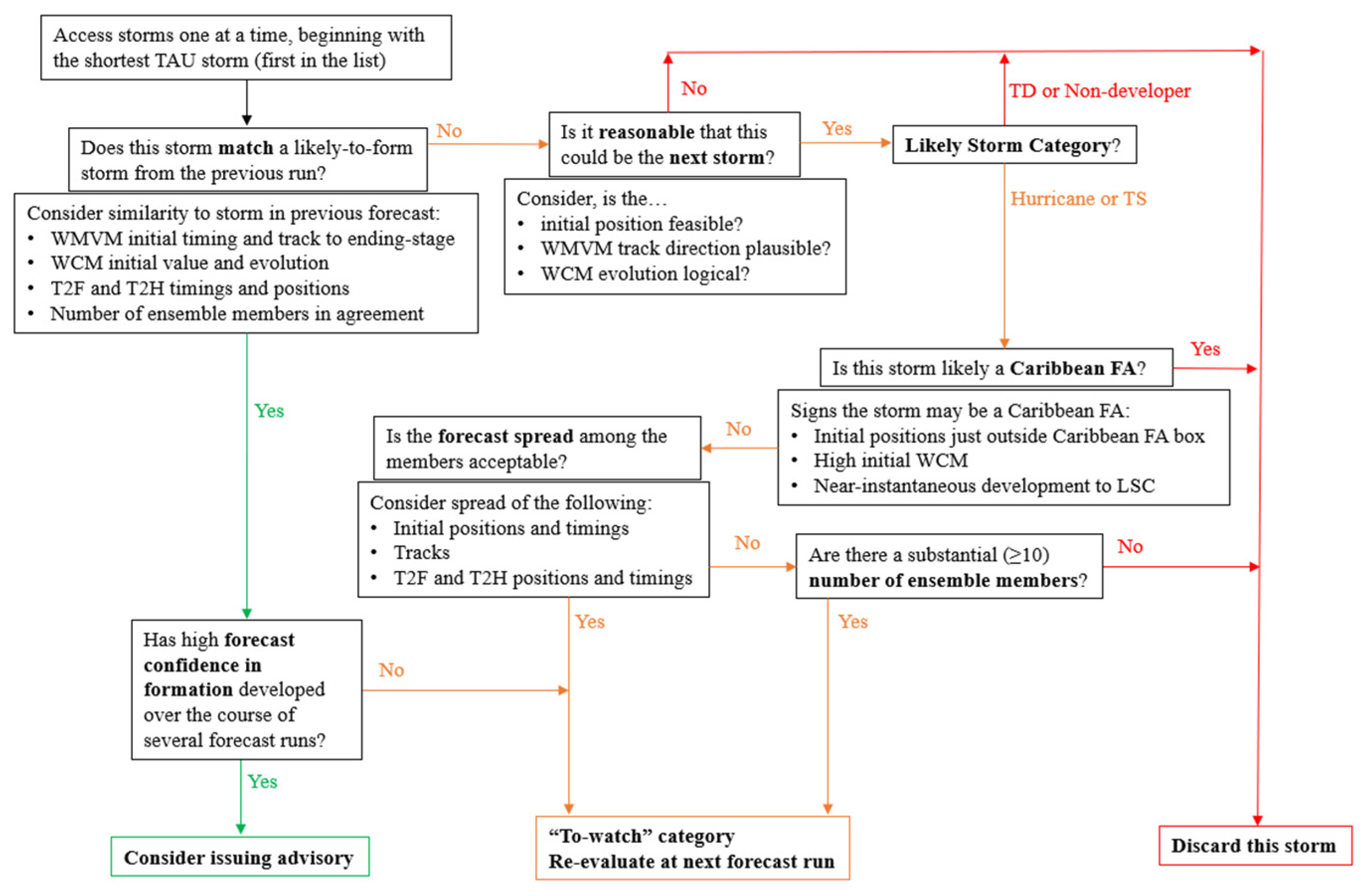
An outcome of evaluating the pre-formation ECEPS forecasts in near-real time in the eastern North Pacific during the 2021 hurricane season was that a decision flowchart was created to select the most likely Tropical Storms to develop (Figure 5). The Marchok vortex tracker outputs from the ECEPS pre-formation forecasts need to be critically evaluated for validity for overall quality control. Many of these future disturbances are being forecast at very long lead times in the 15-day ECEPS forecasts. Because of the greater uncertainty/spread among these early disturbance initial positions, tracks, and WCM values, they must be examined with a forecaster’s discerning eye. Furthermore, even if a potential disturbance is deemed reasonable, it must be matched with a similar disturbance in a previous forecast and must exhibit consistencies run-to-run within these forecasts in order to build forecaster confidence.
In order to evaluate consistency in the forecasts over time, critical details from each likely ensemble storm forecast are compiled in a summary table for comparison and to keep track of how the pre-formation disturbance forecasts develop over time. The summary table for a given disturbance includes the forecast initial time, predicted T2TS and T2HU timings and positions, and in the post-storm analyses in this study, includes the calculated errors between the predicted timings and positions and the actual timings and positions from the working best tracks (WBTs), which are utilized because the post-season BTs are not available. This decision flowchart is offered to be used by a forecaster as a guide to methodically evaluate each potential storm output each forecast run. Following the practice during the near-real time evaluations during the 2021 season, the decision flowchart begins with the forecaster examining the first storm option in the list from that ECEPS forecast initial time, which is referred to as the shortest Tau storm, where Tau is the estimated time (in hours) until the ensemble storm starts. Because the shortest Tau potential storm is the first forecast, the shorter Tau storms generally have a higher likelihood of matching with a storm from a previous forecast run.
In this first step, the forecaster evaluates this shortest Tau storm for consistency with the storm variables from the previous forecast initial time based on the following items: WMVM initial timing and position and the general track agreement even to the ending-stage, T2TS and T2HU (if applicable) timings and positions, numbers of ensemble members in agreement, and the WCM evolution. If this new ensemble storm can be matched with an existing pre-formation ensemble storm predicted to form from the previous forecast, and there is fair consistency in the forecast development and TC formation, the forecaster can proceed through the decision flowchart to consider whether the confidence level is high enough to consider issuing an alert, advisory, or a warning (Figure 5, bottom-left decision). If the confidence in the series of storm forecasts has not reached this level, then the ensemble storm should be placed in the “To-watch” category (bottom-middle decision). The storms in this category are documented and checked again in future ECEPS forecasts for potential matches in order to build forecast confidence.
If this shortest Tau storm cannot be matched with a storm from the previous forecast run, the forecaster then moves to the middle-top step to evaluate whether the forecast reasonably indicates the next ensemble storm. That is, the forecaster evaluates the location within the basin, the season, and the synoptic background conditions when considering the validity of the pre-formation disturbance’s forecast WMVM initial position and track direction, and the WCM evolution. If these forecast conditions are not reasonable or feasible, the decision is to discard the storm option (Figure 5, lower-right decision). For example, the storm may be a cold-core storm rather than a TC. If the forecast is reasonable, but in the Likely Storm Category (LSC) is TD or N/A (i.e., the storm is forecast to not develop even to a TD), the decision flowchart again arrives at the decision to discard the storm option, as it is not forecast to be a threat. At the forecaster’s discretion, if the storm track indicates it does pose an immediate threat, and there may be reason to believe the ECEPS is under-forecasting the intensity, the storm may be put in the “To-watch” category (Table 5, lower-middle decision) until the disturbance is either picked up by a later forecast as a developing TC or a final decision is made that it is a non-developer.
If the forecast is reasonable and the LSC is Hurricane or TS, the forecaster should immediately check whether the storm may be a Caribbean FA (Figure 5, middle-right decision box). The following are signs that an ensemble storm may be a Caribbean FA: the initial positions of a few or most of the ensemble members are just outside the established Caribbean FA box; there is too high initial WCM to be reasonable for a new ensemble storm, and the WCM indicates near-instantaneous development to the LSC of Hurricane or TS. If these signs are present and the storm is strongly suspected to be a Caribbean FA, the decision is to discard the storm.
If there is not convincing evidence that this potentially intense ensemble storm is a Caribbean FA, the forecaster then evaluates the spreads among the members’ initial positions and timings, subsequent tracks even to the ending-storm stage, and the T2TS and T2HU positions and timings. If the spreads of these critical forecast metrics are excessive such that the forecaster is unable to project an acceptable forecast with reasonable confidence, the storm may be placed in the “To-watch” category only if the number of ensemble members meets or exceeds 10. Through the analysis conducted in this study and previous studies by Elsberry et al. [1,4], a substantial number of members have been defined as ≥10. Otherwise, the storm should be discarded. If the ensemble members agree to an acceptable level, then the forecaster puts the ensemble storm in the “To-watch” category (Figure 5, lower-middle decision).
All the storms selected for the “To-watch” category may be considered likely storms to form, although not necessarily the most likely to form. A summary table should be created for these “To-watch” category storms to follow the potential development in future ECEPS forecasts. If the new ensemble storm does closely match a storm from the prior forecast run, that new ensemble storm may be considered to be the most likely storm to form. The forecaster must now evaluate the confidence level in the likelihood of the formation. If the confidence has developed over the course of several forecast runs (≥4), the forecaster may consider issuing an advisory for this storm. Of all the steps in the decision flowchart, this step particularly requires the forecaster’s judgement and expertise.
While in this study this decision flowchart is used as the sole guidance, forecaster judgements and experience could not be incorporated. The summary tables included in this study are based on raw model output and, while the storms are selected intentionally through the decision flowchart, no forecast adjustments have been attempted. In operational use, the decision flowchart is meant to be considered alongside existing procedures and used in conjunction with existing forecast tools. Decision flowcharts should be weaved into established confidence levels when internally tracking or deciding to publicly issue (or not) any sort of alert on potential storms. The methods to systematically evaluate each storm must be efficient because of the forecasters’ time constraints, and because the TC forecasts have to be posted on a tight schedule.

4. Hurricane Category Examples

4.1. Decision Flowchart Application to Pre-Enrique

Hurricane Enrique was the first hurricane of the eastern North Pacific 2021 season. As was illustrated in Figure 4, the Enrique track was close to the west coast of Mexico, and yet it underwent rapid intensification (RI), which is defined as a maximum sustained wind speed increase of ≥30 kt within 24 h. Although this RI phenomenon occurred following formation with almost every Hurricane in this basin during the 2021 season (Elsberry et al. [1]), these RI events are rarely forecast (Courtney et al. 2019) [7]. Indeed, the NHC advisories compared with these ECEPS forecasts rarely did include an RI following formation. As Enrique neared the southwestern coast of Mexico, it brought strong winds, widespread heavy rainfall, and subsequent flooding and landslides that ultimately caused two direct deaths in Guerrero and damage to over 390 homes in Guerrero and Coahuayutla (Latto 2021) [8].
The first example of applying the decision flowchart in Figure 5 is how the 12 UTC 16 June 2021 ECEPS Storm 13 option in Table 1 has been selected as the most likely pre-Enrique among other pre-formation storm options. The Storm 13 was entered in the first column, and the alternate storm options considered but not selected are in the last three columns. Note that these non-selected storms are listed from the smallest number to the largest number to be consistent with the ordering of smallest to largest forecast Tau in the decision flowchart. Normally, the selected ensemble storm number will be smaller than the numbers of non-selected ensemble storms, but that was not the case for the Caribbean FA category described earlier in Section 2, in which the FA ensemble storm had the advantage of an earlier precursor circulation. For the 12 UTC 16 June ECEPS forecast (Table 1, row 1), the selected Storm 13 had 16 members and all three alternate storms options (Storm 9, Storm 11, and Storm 12) had lower numbers.
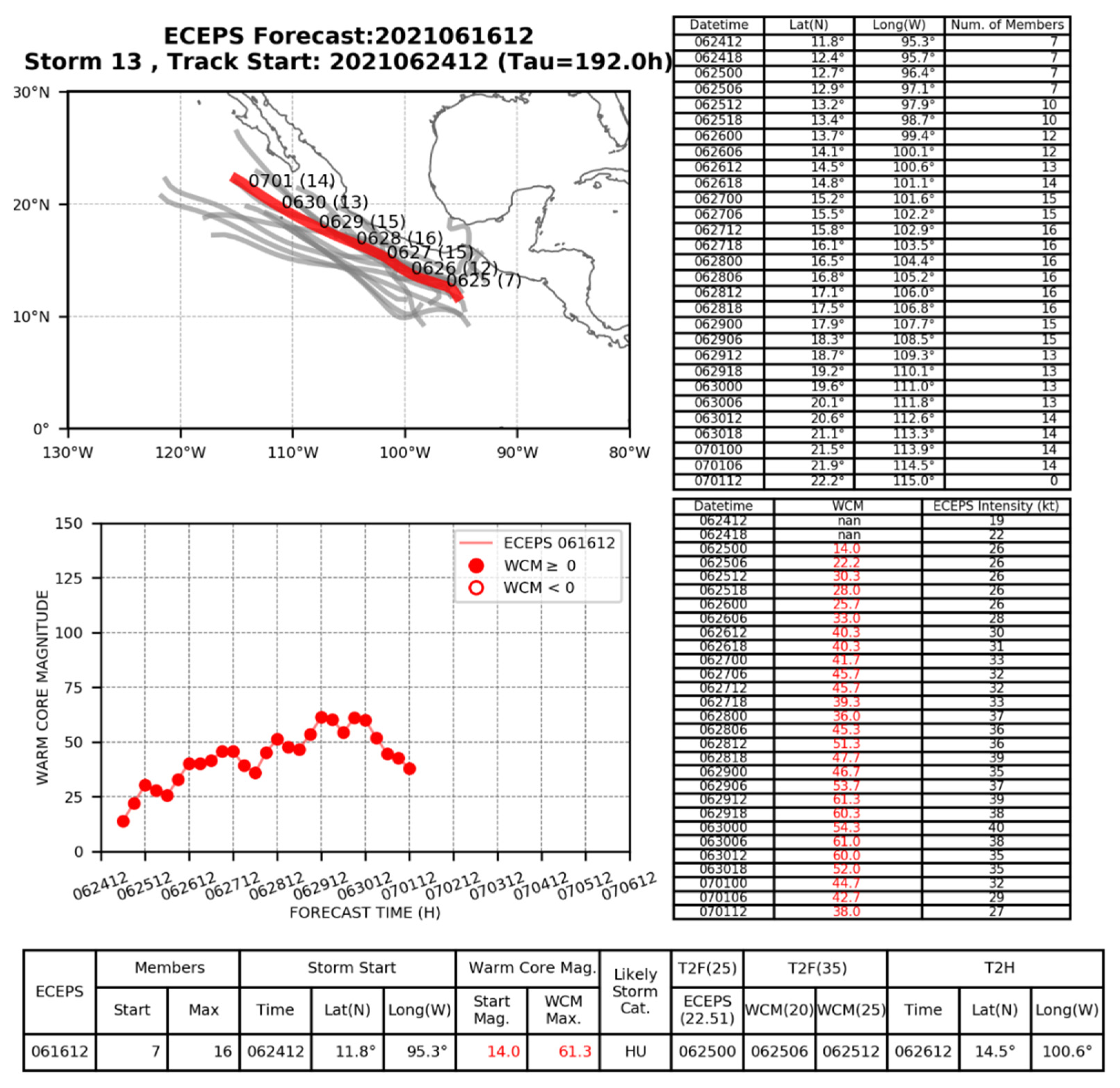
In the first step of the decision flowchart, Storm 13 could not be matched with an ensemble storm from a previous forecast because there were no likely-to-form storms selected previously that had similarities in WMVM initial timing and track, WCM initial value and evolution, T2TS and T2HU timings and positions, or numbers of ensemble members in agreement. Therefore, the next step is to evaluate whether it is reasonable that this could be the next storm. Storm 13 was ultimately determined to be reasonable based on the instruction in the decision flowchart to evaluate the initial position and WMVM track direction, and WCM evolution. The digital values of the first seven days of the WMVM track forecast and the numbers of members each six hours are shown in the table in the upper-right of Figure 6. The digital values of the WCM that are used to determine the T2TS, and the ECEPS storm intensity that is used to estimate the T2F (25 kt, i.e., Tropical Depression) are shown in the table in the lower right of Figure 6. The WMVM Storm 13 starting time of 12 UTC 24 June and Storm 13 start location near 11.8° N, 95.3° W, which are found in the “Storm Start” section of the summary table at the bottom of Figure 6, are plausible for this time of year and this location of the eastern North Pacific basin. As listed in the summary table at the bottom of Figure 6, the predicted evolution from the T2F (25) at 00 UTC 25 June near 12.7° N, 96.4° W to the T2TS threshold value of WCM (25) at 12 UTC 25 June near 13.2° N, 97.9° W, and then to T2HU at 12 UTC 26 June near 14.5° N, 100.6° W are certainly reasonable as is the northwestward WMVM track direction (Figure 6, red track in upper-left plot).
The forecaster then moves to the next step in the decision flowchart (Figure 5) of determining the Likely Storm Category (LSC) for Storm 13, which is provided in the “Likely Storm Cat.” center section of the summary table at the bottom of Figure 6. Because the Storm 13 LSC was Hurricane (HU), the forecaster then moves to the next step in the decision flowchart, which is to look for signs that Storm 13 may be a Caribbean FA. As discussed in detail in Section 2 and Section 3, the signatures of a Caribbean FA are the following: (i) the initial positions of most or all of the ensemble members are just outside the established Caribbean FA box; (ii) there is too high initial WCM to be reasonable for a new ensemble storm; and (iii) the WCM evolution indicates near-instantaneous development to the LSC of Hurricane or TS. Whereas the initial position of Storm 13 was sufficiently far outside of the established Caribbean FA box indicated in Figure 4c, the initial value of the WCM (14.0, lower-right table) was not too high initially, and the LSC estimated from the maximum WCM value (61.3, bottom of Figure 6) was not achieved instantaneously. Therefore, there were no clear signatures of a Caribbean FA for Storm 13.
The forecaster then moved to the next step in the decision flowchart (Figure 5) of examining the spread among the ensemble member tracks, which are represented by the gray tracks in the upper-left plot of Figure 6. While there was a fair amount of spread in initial positions and tracks, which should be expected at the long forecast Tau of 192 h (indicated in the text at the top of Figure 6), the forecaster noted that the track spread decreased as the general northwestward track direction became well established. In this case, the decision flowchart concluded with the selection of Storm 13 for the “To-watch” category with the instruction to re-evaluate the potential of this storm at the next forecast run.
Even if the forecast spread among the ensemble member tracks had been considered to be too large, the forecaster would have moved to the next step of checking the ensemble member count. The maximum ensemble member count for this storm was 16, which is indicated in the “Members Max” section in the summary table at the bottom of Figure 6. Consequently, Storm 13 has a substantial number of ensemble member tracks, which has been established as ≥10. With this number of ensemble member tracks, even if the forecast spread had been questionable, Storm 13 would be placed in the “To-watch” category. Ultimately, this storm was selected as the most likely storm to form from this ECEPS forecast initial time and later became Hurricane Enrique.
The second application of the decision flowchart is to guide the forecaster in non-selection among the many storm options provided by the 51-member ECEPS. Capalbo [4] describes this application of the decision flowchart for the three alternate storm option (storm 9, 11, and 12) to the selection of storm 13 from the 12 UTC 16 June ECEPS forecast. For example, storm 9 in Table 1 was non-selected because it is a subtropical cyclone and the ECEPS-predicted WCM evolution indicated it is a cold-core system. Since during the 2021 season none of these cold-core systems developed into a ENP TC, a decision has been made to eliminate all cold-core systems in the step 3 of Table 1. Consequently, the forecaster will not be presented any cold-core Storms for evaluation, which will make the decision flowchart procedure more efficient.
Capalbo [4] notes that Storm 11 may be a Caribbean FA because a single ensemble storm track that starts near 6° N, 95° W appears to be the precursor track to start the Storm 11 WMVM track. However, the non-selection of Storm 11 in Table 1 was because there was not a substantial (≥10) number of ensemble member tracks—there were just eight.
Capalbo [4] labels Storm 12 as a Caribbean FA because a single ensemble storm track that starts near 10° N, 95° W appears to be the precursor track to start the Storm 12 WMVM track. This would not be an easy decision for a forecaster because the WMVM track forecast is quite similar to the selected Storm 13 track in Figure 6, and the ECEPS-predicted WCM evolution also indicates the potential for Hurricane intensity [4] Figure 13. Capalbo [4] also demonstrates the application of the decision flowchart 12 h later than knowing the selection of Storm 13 from the 12 UTC 16 June forecast. That is, the forecaster would have easily selected the ECEPS 00 UTC 17 June Storm 14 as the match based on striking similarities. That is, the T2TS timing was exactly consistent, the Storm Start timings and positions were very similar, and the maximum WCM was similar. Both of these storms were predicted to be hurricanes and pass close to the west coast of Mexico [4] Figure 7. This situation illustrates the critical role of the forecaster in the decision flowchart as an Alert may be already warranted.
Since Storm 14 was considered to be matched with Storm 13 of 12 UTC 16 June, it was added to the summary Table A1 in Appendix A. The choice for pre-Enrique from the 00 UTC 17 June ECEPS forecast in the summary Table A3 (row 1) was Storm 14. Selections of the ensemble storms that best represent the pre-Enrique storm in the remainder of ECEPS forecasts from 12 UTC 17 June through 00 UTC 22 June are listed in the first column of Table A1. Note how consistent in time are the T2F (35) times, and these times turned out to be clustered around the verifying T2F (35) time of 06 UTC 25 June. This consistent T2F (35) timing of 12 UTC 25 June (column 2) through the first three ECEPS forecasts in Table 2 and Table 3 would build early confidence that this is the pre-Enrique disturbance. Several of the selected storms were placed in the “To-watch” category. For instance, between 12 UTC 16 June and 00 UTC 18 June, there was not enough confidence in the consistency of the forecasts to issue an advisory, but the forecasts showed evidence of a plausible future storm with a LSC of Hurricane. Thus, they were watched and added to the summary table. Progressing in time through the forecast runs, as the non-selected storms were ruled out for these various scenarios and the selected storms are chosen, a level of confidence in the selected matching storms must still be met in order to seriously consider issuing an advisory. It was tentatively determined through the course of this study that four or more consecutive and high consistency storms should be matched in the “Selected storm” column before considering issuing an advisory. However, if the pre-formation storm is expected to rapidly become a hurricane and be a threat, the forecaster may not want to wait for four consecutive forecasts (two days).
Note that the three alternative ensemble Storms to Storm 14 of the 00 UTC 17 June ECEPS forecast include Storm 11 and Storm 17 (Table A1, row 1) that were both non-selections as Caribbean False Alarms. Capalbo [4] provides detailed descriptions of these two Storms. While Storm 11 began at 12.1° N, 100.9° W, which is well outside of the Caribbean False Alarms box, two of the three ensemble member tracks necessary to begin a WMVM track forecast began just to the west of the box.
Similarly, Storm 17 starts near 13.4° N, 96.6° W that is well outside of the box, but a single ensemble member track begins near 12° N, 94° W is likely to be the precursor circulation for Storm 17. What makes the non-selection of Storm 17 as an alternative is that the WMVM track forecast is just offshore of Mexico and the ECEPS-predicted WCM of 55.7 is indicative of a Hurricane. Until a more comprehensive definition for a Caribbean False Alarm is developed, it is essential that a forecast be involved in the evaluations of these ECEPS ensemble storm forecasts near the west coast of Central America.
Capalbo [4] suggests that four or more consecutive and high consistency storm matches in the “Selected Storm” column of Table A1 should exist before the forecaster considers issuing an advisory.

4.2. Decision Flowchart Application to Pre-Felicia

Felicia formed in the far eastern North Pacific about three weeks after Enrique (Cangialosi 2021) [9]. Felicia also underwent RI and became a powerful Hurricane as it tracked mainly westward. Although Felicia did cross the critical 140° W boundary into the central North Pacific basin, it did so as a remnant low. According to NHC advisories, the Felicia T2TS was 12 UTC 14 July with a position near 14.2° N, 113.4° W, and the T2H was 06 UTC 15 July with a position near 15.1° N, 117.1° W.
Table A2 is a summary of the application of the decision flowchart to the ECEPS forecasts of pre-Felicia. Note in Table A2 that the first ECEPS forecast for pre-Felicia began at 12 UTC 2 July, which is an amazing 12 days prior to formation, and yet had high accuracy in T2TS and T2HU timings (column 2) and positions. That is, the timing errors for the T2TS did not exceed 30 h in any of the forecasts through 12 UTC 11 July. These T2TS timings (column 2) tended to be early, and thus eastward for a westward-moving storm, until after the 00 UTC 7 July forecast, when the errors then tended to be late and westward. Elsberry et al. [1] documented the T2HU errors followed similar trends and were also remarkably small. This guidance beginning 12 days in advance of the T2TS is concluded to be an early and accurate indicator of Felicia’s eventual formation, which may be attributed to the use of the decision flowchart in the evaluation of the highly accurate ECEPS early pre-formation forecasts such as these.
Capalbo [4] provides a description of the selection of Storm 6 from the 12 UTC 7 July ECEPS forecast as the most likely pre-Felicia (Table A2, row 1, column 1) and the reasons for the storm non-selections in column 3–5. For this pre-Felicia case, the focus was on the other storm options in columns 3–5 in Table A2 that were not selected as the most likely storm to form if they fell into a category or multiple categories for non-selection. These non-selection categories include the following: poor consistency with previous forecast(s) in critical aspects such as the WCM evolution that indicates LSC, which appears 23 times; too few members, which is tentatively defined as less than 10, appears 16 times; cold-core system rather than a warm-core TC, which appears six times in Table A2; Caribbean FA which appears five times, and poor track and/or WCM agreement among the members, although this factor appears only once. Because this series of ECEPS forecast started 12 days prior to the T2TS, the forecaster would have to evaluate with the decision flowchart a large number of ensemble storms that were simply too inconsistent to be matches with the pre-Felicia selections in each of the previous forecasts.
What stands out in Table A2 is that beginning already with the 00 UTC 3 July through the 12 UTC 4 July forecasts, one or two of the non-selected storm options in most of these ECEPS forecasts had an “inconsistent WCM evolution” or an “inconsistent storm start position” as the reason for non-selection as a possible pre-Felicia. Considering the ECEPS 12 UTC 7 July forecast as an example, because two of the three non-selections have that same reason, the application of the decision flowchart would have selected Storm 6 in Figure 7 as the most likely pre-Felicia (see Capalbo [4] for explanation). This Storm 6 WMVM track important because it start at 00 UTC 11 July near 8.7° N, 96.6° W and represents a potential threat to Hawaii sometime after 20 July. Furthermore, the ECEPS predicted WCM evolution (lower-left panel) indicates the T2HU of 12 UTC 15 July with a peak intensity at 00 UTC 17 July and then a slow decay. Capalbo [4] explains that the first “inconsistent Storm start position” of 9.3° N,118.4° W for Storm 3 would be easily recognized by the forecaster since the previously selected pre-Felicia Storm was much far then to the east near 8.0° N, 99.1° W. However, such a recognition by the forecaster would not be so easy for the Storm 8 starting position near 10.6° N, 108.2° W at 06 UTC 12 July, 8.7° N, 96.6° W. Interestingly, the Storm 8 starting longitude is about midway between that Storm 6 longitude (Figure 7) and the Storm 3 longitude. All three (Storm 3, Storm 6, and this Storm 8) have tracks toward Hawai’i and thus are of high interest, especially as all three have WCM evolutions that have LSCs of a Hurricane at around 16–17 July (Capalbo [4]). Another common non-selection factor in the decision flowchart for both Storm 3 and Storm 8 is that both have only eight (i.e., less than the tentative < 10 member condition) ensemble members in this 00 UTC 7 July ECEPS forecast. However, looking earlier in Table A2, there were also two “inconsistent Storm start position” decision for the 12 UTC 4 July and the 12 UTC 6 July ECEPS forecasts, and it is possible/likely that missing 12 UTC 5 July ECEPS forecast would have also had the two same decisions. While the forecaster at 12 UTC 7 July would not have had access to the subsegment forecasts in Table A2, it is noted that almost all of those forecasts had two non-selection with “inconsistent” storm start, WCM, T2H, or T2F characteristics. Recalling again that both Storm 3 and Storm 8 from that 12 UTC 7 July ECEPS forecast only had eight members, but had forecast tracks threatening Hawaii, this calls into question the tentative < 10 ensemble member non-selection condition in the decision flowchart (Figure 5). Thus, it is recommended that in the future applications of the ENP decision flowchart that the required number of ensemble members be at least eight to start a new summary chart for the next likely storm formation in the ECEPS forecasts. In addition to likely contributing to more, and earlier, next likely ensemble storm detections, it will simplify and make efficient the non-selection process when these “inconsistent” storm option decision do not have to be made as in this pre-Felicia case.
Thus, the application of the decision flowchart to process and interpret the ECEPS forecast guidance has been demonstrated for both Hurricanes Enrique and Felicia. The ECEPS forecast guidance for the remaining hurricanes (Hilda, Linda, Nora, Olaf, Pamela, and Rick) from the 2021 eastern North Pacific season were evaluated in the same manner. The detection timing in advance of T2TS and T2HU by the NHC Advisories and ECEPS forecasts for all the hurricanes of the 2021 ENP season are provided in Table 2 from Elsberry et al. [1]. The detections/warnings in the forecasts of T2TS by the NHC Advisories varied between 0 h and 18 h in advance (average of 7.5 h in advance). In contrast, the detections/alerts in the ECEPS forecasts of T2TS were at least 5 days, 18 h in advance for Hurricane Pamela and at most 12 days, 12 h in advance for Hurricane Olaf and 12 days in advance for Hurricane Felicia with an average of 8 days, 18 h in advance. The detections/warnings in the forecasts of T2HU by the NHC Advisories were as short as 18 h in advance of Hurricane Rick and at most 1 day, 18 h in advance for Hurricanes Linda and Nora, with an average of about 1 day, 6 h in advance. By contrast, the detections/alerts in the ECEPS forecasts of the T2HU were at least 7 days, 2 h in advance for Hurricane Rick and at most 13 days, 12 h in advance for Hurricane Olaf with an average of about 10 days in advance. This study and the results from Elsberry et al. [1] demonstrate that this early and accurate ECEPS forecast guidance has the potential to greatly advance pre-formation forecasts for hurricanes, if implemented and utilized in conjunction with the decision flowchart in Figure 5. A real-time operational test of this technique in the ENP will be carried out by the Joint Typhoon Warning Center during the 2022 Season.

5. Tropical Storm Examples

5.1. Decision Flowchart Application to Pre-Guillermo

Tropical Storm Guillermo formed in favorable conditions in mid-July about 275 n mi southwest of Manzanillo, Mexico (Berg 2021) [10]. Guillermo was a short-lived TS that took a track toward Hawaii but encountered higher wind shear and cooler waters and ultimately weakened and became a remnant low before crossing 140° W. The maximum sustained wind speeds for tropical storms are 34 kt–63 kt, and Guillermo’s maximum sustained winds were estimated to be 50 kt, which is well within the bounds of TS intensity criteria [10].
The NHC included pre-Guillermo in their TWO leading up to issuing advisories. The 5-day outlooks first indicated a disturbance with <40% chance of formation 192 h prior to formation, then a 40–60% chance 162 h prior, and >60% chance 138 h prior [8]. The 2-day outlooks indicated <40% chance 54 h prior, then 40–60% just 36 h prior, and >60% only 18 h prior to formation. Note that these outlooks do not provide forecast details such as likely track or intensity evolution. The first advisory issued by the NHC was at 12 UTC 17 July, which is only six hours ahead of formation. Except for Advisory 3, each of the Advisories 1–6 forecast that the peak intensity would be 55 kt. Note that pre-Guillermo became a TS just three days after pre-Felicia had become a TS at 12 UTC 14 July and then rapidly intensified to a Hurricane at 06 UTC 15 July. Since pre-Guillermo was presumably also in a favorable environment for RI and thus would soon become a Hurricane, Elsberry et al. [1] designated it as “Almost-Hurricane Guillermo” in part because the ECEPS track forecast was toward Hawaii and the ECEPS was consistently predicting such a RI following the T2TS.
During post-storm analyses of Guillermo and other tropical storms, it was determined that a disturbance achieving the WCM (20) threshold for the T2TS timing was more accurate than the time for achieving the WCM (25) threshold. Consequently, the WCM (20) threshold was used by Elsberry et al. [1] for both the pre-formation and the TETS timing for TS Guillermo. In addition, Elsberry et al. [1] provide a summary diagram (their Figure 19) of the pre-formation and ending-stage Guillermo WMVM track forecasts and the pre-Guillermo and ending-Guillermo timing errors similar to the Hurricane Linda diagram in Figure 1.
A summary of the selections and non-selections of the ECEPS Storm forecasts related to pre-Guillermo is given in Table A3. The first ECEPS forecast in which a pre-formation circulation was detected that later (06 UTC 16 July) was predicted to become TS Guillermo was Storm 8 in the 00 UTC 9 July forecast (Table A3, rows 1–2). Although that T2TS forecast later was validated to be early by 36 h, this ECEPS forecast was initiated almost nine days in advance of the Guillermo T2TS, and more than five days in advance of the Felicia T2TS farther to the East. Thus, the ECEPS was simultaneously forecasting the pre-formation stages for both Felicia and Guillermo.
In the pre-Felicia discussion in Section 4.2, there were three non-selected ensemble storm options in the ECEPS forecast from 12 UTC 7 July (Table A4, row 11, columns 3–5). Recall that Storm 3 and Storm 8 were non-selected with the reason “inconsistent storm start”, which should be interpreted as inconsistent with the previously selected pre-Felicia storm initial positions. Storm 3 started far to the west of the selected pre-Felicia Storm 6 and Storm 8 in that ECEPS forecast from 12 UTC 7 July started between Storm 3 and 6. Although it is difficult to trace the storm numbers in column 3–5 Table A2 after 12 UTC 7 July, it does appear that it was Storm 8 in that ECEPS forecast that later is the first detection of pre-Guillermo Storm 8 in the 00 UTC 9 July forecast in Table A3.
In conclusion, during an active/favorable TC formation period in the ENP, indicated first by only a 3.25-day difference in the T2TS for Guillermo after the Felicia T2TS and secondly by all three of the non-selected storms had WCM evolutions indicating an LSC of Hurricane, a non-selected storm with a category of “inconsistent storm start position” of an existing Hurricane may actually be an early precursor of the next TC.
The forecasts from the following ECEPS initial times were evaluated in the same way and the selected storms and the reasons for non-selection of alternate storm options are also provided in Table A3 in columns 3–5. Note after two T2TS timing error validations of early 30–36 h, there were eight consecutive forecasts from 12 UTC 10 July through 00 UTC 14 July in which timing errors were only six hours to 12 h early. As an example, Storm 4 from the ECEPS initial time 00 UTC 14 July (Table A3, row 11) was selected and is displayed in Figure 8. Not only is this Storm 4 evaluated as a disturbance likely to form, the WMVM track forecast (upper-left panel) indicates a possible direct hit on the Hawaiian Islands. Furthermore, the WCM (20) evolution is indicative of a T2TS at 06 UTC 17 July and a T2HU at 12 UTC 18 July. Even though this pre-Guillermo disturbance is predicted to begin to decay from its peak intensity at 06 UTC 21 July near 17° N, 129° W, an alert regarding the potential hurricane may be considered by the forecaster.
Just as in Table A2 for Pre-Felicia, the most frequent (16 times) reasons for a non-selection option for Pre-Guillermo in Table A3 are “inconsistent storm start”, “inconsistent WCM” or “inconsistent WMVM track”. It is possible/likely that these storm option non-selections as a match for the selected Pre-Guillermo storms in column one of Table A3 may be the second non-selected “inconsistent” storm option for Pre-Felicia in Table A2. That is, it is possible that during this active period in the ENP with Pre-Felicia and Pre-Guillermo developing within ~3 days, ECEPS may have also forecast another pre-TC circulation that was long-lasting but did not become a TS. If we had started another summary chart for Storm 3 (recall if only had eight members) in the 12 UTC 7 July ECEPS forecast, we may have been able to identify Storm 3 as a “non-developer” again, it would have simplified and made more efficient the non-selection process for Pre-Guillermo if these repeated “inconsistent” storm option decisions did not have to be made by the forecaster.
The breakdown of the non-selection scenarios for strong TS Guillermo in Table A3 are thus comparable to those of Hurricanes Enrique and Felicia as discussed in Section 4.1 and Section 4.2, respectively. It is noteworthy that the first detection in the ECEPS forecasts in Table A3 for pre-Guillermo is 8 days, 18 h in advance of the T2TS, which is comparable to the first detections for the pre-Enrique at 9 days, 6 h and for the pre-Felicia at 12 days. Elsberry et al. [1] provided a validation summary diagram for the pre-formation and ending-stage ECEPS forecasts of what they labelled as Almost-Hurricane Guillermo that was predicted to threaten the Hawaiian Islands (not shown). While Guillermo turned out to be a strong TS, the ECEPS-predicted maximum WCM consistently indicated a LSC of Hurricane from the first (00 UTC 9 July) forecast through the 12 UTC 15 July forecast (not shown). Thus, it was only after the 00 UTC 16 July forecast (but still 1.75 days prior to the T2TS) that the ECEPS-predicted maximum WCM indicated that Guillermo would only be a strong TS instead of a Hurricane. This strong TS Guillermo is another example of how ECEPS forecasts provide an opportunity for improved, earlier, pre-formation guidance. If the ECEPS forecast guidance is evaluated with the decision flowchart and weighed by the forecaster along with their other forecast tools, high wind warnings for the whole lifecycle of TS Guillermo may be provided well ahead of its formation.

5.2. Decision Flowchart Application to Pre-Jimena

Pre-Jimena began as a disturbance far south-southwest of the southern tip of Baja California, and then developed into a weak TS in early August. TS Jimena was one of the few storms during the 2021 ENP season that did not originate in the favored formation area south of the Gulf of Tehuantepec. Instead, pre-Jimena began near 15° N, 125° W and had a northwestward path that might have threatened Hawai’i if it had persisted (Pasch 2021) [11]. Jimena’s maximum sustained winds were 35 kt, which qualifies Jimena as a very weak TS. The pre-Jimena disturbance did cross 140° W into the Central Pacific Hurricane Center Area of Responsibility on 6 August as a Tropical Depression and was shortly afterward declared a remnant low. Nevertheless, post-storm Jimena brought significant amounts of moisture and brief bouts of heavy rainfall over parts of Hawaii, particularly to eastern Kaua’i and southern portions of the Big Island [11]. Fortunately, there were no reports of damage or injuries associated with the heavy rainfall.
Capalbo [4] provides a summary of the NHC advisories issued for pre-Jimena. In contrast to the eight hurricanes summarized in Table 2 in which the average time-in-advance of NHC advisories prior to the T2TS was only 7.5 h, there were nine NHC advisories for pre-Jimena, which included a period between 06 UTC 1 August and 18 UTC 4 August during which TS intensity was not predicted. The first NHC Advisory issued at 18 UTC 30 July forecast a T2TS at 06 UTC 1 August, which turned out to be early by four days. In addition, a peak intensity of 50 kt was forecast at 18 UTC 4 August, which was 12 h before the actual T2TS. NHC continued to be aggressive in forecasting an early T2TS and a peak intensity beyond 35 kt through Advisory 6. It was only in Advisory 8 after the four-day gap in forecasts, and only 12 h in advance of the T2TS, that very accurate T2TS timing and position forecasts became available.
Applying the decision flowchart (Figure 5) to each of the storm options from the ECEPS forecasts, the selections of the ensemble storms that were most likely to become pre-Jimena are provided in Table A4, column 1. As for TS Guillermo, a WCM (20) threshold is used for the T2F (35) timing (Table A4, column 2), as most of the early selected ensemble storm options forecast the pre-Jimena disturbance would only be a TS. As was the case for the NHC advisories (Capalbo [4], Table 13), the first ECEPS forecast in which a pre-Jimena circulation was detected at 00 UTC 31 July (Table A4, row 1) and the T2TS forecast timing of 06 UTC 3 August (column 2) was quite early (72 h). Except for the 00 UTC 2 August forecast, the early T2TS forecasts continued through the 12 UTC 2 August forecast, and then the timing forecasts through 00 UTC 5 August were quite accurate (within 12 h).
The initial selection of Storm 2 from the 00 UTC 31 July ECEPS forecast (Table A4, row 1) is a clear choice among the other storm options that all have low ensemble member counts: Storm 5 with five members, Storm 6 with eight members, and Storm 7 with four members. By contrast, Storm 2 from this ECEPS forecast had all 51 ensemble members included and was a reasonable forecast with a LSC of Hurricane (not shown), although this LSC was correctly updated to TS in the following forecast (not shown). Clearly, Storm 2 is the most promising as the next potential storm to develop and this particular disturbance is marked as one “To-watch”, and the summary table is begun.
Given this Storm 2 selection for the 00 UTC 31 July forecast, the other ECEPS forecasts of pre-Jimena are evaluated through the decision flowchart by comparing the critical forecast items including member count, storm start and T2TS timings and positions, WCM evolution, and the WMVM track. For example, the ECEPS 12 UTC 1 August forecast Storm 4 is shown in Figure 9. Note again that all 51 ensemble members are included and the WMVM track forecast passes just to the south of the Hawaiian Islands. The T2TS based on the WCM = 20 threshold of 12 UTC 3 August is still early (Table A4, row 4, column 2). However, the maximum WCM is now only 27.0, which is indicative of a LSC of (weak) TS (bottom summary table in Figure 9).
The subsequent ECEPS forecasts of the ensemble storm options that are evaluated through the decision flowchart are provided in the selection and non-selection summary table (Table A4). For pre-Jimena, the non-selection scenarios for the alternate storm options (Table A4, columns 3–5) included: inconsistencies with the previous forecast run(s), which appears 20 times in Table A4; insufficient number of ensemble members, which appears three times; LSC of TD, which also appears three times; cold-core system rather than a warm-core TC, which appears two times; and poor ensemble member agreement, which also appears two times. All of these non-selections would be easily recognized by the forecaster.
Capalbo [4] provides a summary validation table for the ECEPS forecasts of pre-Jimena. As indicated above, the first detection in the ECEPS forecast from 00 UTC 31 July is at almost the same time as the first NHC Advisory for Jimena (i.e., about six days in advance of the Jimena T2TS of 06 UTC 5 August). The two ECEPS forecasts on 31 July had very early predictions of the T2TS with timing errors of (early) 72 h and 102 h (Table A4, column 2). Whereas the first of these two forecasts incorrectly predicted that pre-Jimena would become a Hurricane 30 h after the T2TS, the second forecast had only a peak WCM forecast of 32.7, which corresponds to a strong TS. Capalbo [4] notes that from the second ECEPS forecast until the last forecast at 12 UTC 5 August when Jimena became a TS, there was only one other forecast (12 UTC 2 August) that predicted a strong TS. Instead, three forecasts had peak forecast WCM values just over the larger WCM threshold of 25.0, and five were just over the lower WCM threshold of 20.0. Due to these highly accurate WCM predictions, the T2TS timing errors were also accurate with six of the seven forecasts from 00 UTC 2 August to 00 UTC 5 August having timing errors of either the exact time or early by 12 h (Table A4, column 2). With these accurate T2F (35) timing errors, and accurate WMVM track forecasts, the T2TS position errors were very small for those six out of seven ECEPS forecasts from 00 UTC 2 August to 00 UTC 5 August, which was important since the WMVM track forecasts were toward the Hawaiian Islands (Figure 9). Furthermore, the capability of the ECEPS-predicted WCM to indicate that pre-Jimena would remain a weak TS is important for avoiding unnecessary disaster preparedness activities in Hawaii.

5.3. Summary of Application of Decision Flowchart for ENP Tropical Storms

Availability of a decision flowchart such as Figure 5 is critical to guide the forecaster to select the likely-to-form ensemble storms. The effectiveness of the decision flowchart has been demonstrated for TSs Guillermo and Jimena. The remaining tropical storms of the 2021 ENP season (Andres, Blanca, Carlos, Delores, Ignacio, Kevin, Marty, Terry, and Sandra) were also evaluated using the ECEPS forecast guidance and the decision flowchart. Since TS Marty formed from the remnants of Hurricane Grace in the Atlantic basin, these early detection techniques are not applicable and thus Marty is not included. The first detection timing in advance of T2TS by the NHC Advisories and by the ECEPS forecasts for all of these tropical storms (excluding Marty) is provided in Table 3. Note that the first detections in the forecasts of T2TS by the NHC varied between only 6 h in advance for several storms and 5 days, 12 h in advance for TS Jimena, with an average of 1.2 days in advance. In contrast, the first detections in the ECEPS forecasts for T2TS were at least 2 days, 6 h in advance for TS Terry and at most 9 days, 18 h in advance for TS Sandra with an average of 6 days, 18 h in advance.
In conclusion, the ECEPS forecast guidance processed through the Marchok [5] vortex tracker and here evaluated through the decision flowchart is proven to be a reliable early and accurate indicator of the tropical storms in the ENP during the 2021 season. If implemented at TC warning centers, and used in conjunction with the decision flowchart, this forecast guidance presents the opportunity for much earlier detection of disturbances during the pre-formation stage and for provision of lifecycle high wind warnings for up to 15 days.

6. Decision Flowchart Application to Non-Developing Disturbance

In addition to hurricane and tropical storm extended-range forecasts, these ECEPS forecasts have application to non-developing disturbances. During the 2021 ENP season, there were several examples of the ECEPS forecasts that detected a disturbance with fairly high confidence (i.e., consistent forecasts with high member agreement) in its non-development. One of these examples is detailed in this section.
The ECEPS 00 UTC 25 September forecast first identified a disturbance with a start time of 06 UTC 27 September (Figure 10). The forecaster evaluating Storm 4 with the decision flowchart would find that Storm 4 does not match a likely-to-form storm from the previous forecast. Furthermore, while the initial position and the WMVM track forecast were reasonable, the WCM values in the lower-left plot in Figure 15 were continually small with a maximum of 15.0, which corresponds to a LSC of only a TD. In addition, Storm 4 only had a maximum of nine ensemble members, which is shown in the lower-left section of the summary table in the bottom of Figure 10. Normally, this Storm 4 option would be discarded as a not-likely-to-form storm. However, this was a situation in which there had not been any TSs for a period, and Storm 4 was placed in a “To-watch” category and a summary table was started.
This disturbance continued to be forecast by the ECEPS with increasing numbers of ensemble members (Table A5, column 3). Since 50 ensemble members were forecasting this disturbance by 12 UTC 1 October, this would certainly indicate it is a real disturbance. The initial positions of the disturbance (Table A5, column 2) forecasts were consistent in time, and according to the decision flowchart the alternate storm options for this disturbance would be discarded for each ECEPS forecast. It is noteworthy that the WCM evolutions never surpassed the T2TS threshold of 20.0, which is indicated in Table A5, columns 4–5 by “Criteria not met.” Because this disturbance was evaluated to be a non-developer for every ECEPS forecast between 00 UTC 25 September and 00 UTC 3 October, the forecaster would be prompted to “Discard this storm” in the lower-right decision box of the decision flowchart (Figure 5) for each forecast run. However, the warning center may delay that decision and continue the summary chart until it was certain that landfall would not occur.
It was not until 12 UTC 29 September that the NHC initiated a Tropical Weather Outlook (TWO) for a disturbance with a 0% formation chance within 48 h and 20% formation chance within 120 h (i.e., formation by 12 UTC 4 October) (Table A5, columns 6–7). The first in this series of numbered disturbances had an initial position roughly near 12° N, 125° W, which is similar to the 12 UTC 29 September ECEPS Storm 1 initial position in Table A5, column 2. The subsequent TWO disturbance probabilities of formation through 12 UTC 2 October were 20% through 48 h and 40% through 120 h, which was a period when the ECEPS Storm forecasts had the largest numbers of ensemble members (Table A5, column 3), although none of these ECEPS forecasts predicted the disturbance to meet the T2TS criteria. However, those TWO numbered disturbances were subsequently terminated at 06 UTC 3 October when the percentages were near- zero chance of formation at both 48 h and 120 h. These early ECEPS ensemble storms are therefore considered to be correct predictions of the non-development of this NHC-predicted disturbance.
While no NHC advisories were issued for this disturbance, the ECEPS guidance would have provided early and high confidence guidance that such a long-lasting disturbance was very unlikely to form. Early and high confidence forecasts in the non-development of tropical disturbances can prevent unnecessary resource protection measures from being initiated, which saves time and money. Particularly within the U.S. Department of Defense (DoD), this non-development forecast would allow the forces to continue to operate as usual, with minimal interruptions or distractions, and keep their focus on their primary missions.

7. Summary and Discussion

Elsberry et al. [1] had transitioned to the ENP their western North Pacific TC technique for forecasting the T2TS and the T2HU along the 15-day ECEPS track forecasts and had documented that their technique provided much earlier T2TS and T2HU forecasts for eight Hurricanes during the 2021 ENF season than are available from the NHC Advisories (see Table 5). In addition, Elsberry et al. [1] documented that the ECEPS was also able to predict the Ending-T2H and Ending T2F (35) along that 15-day ECEPS track forecasts for those eight ENP Hurricanes. While this advancement demonstrated the opportunity for the ECEPS to provide high wind warnings during the entire lifecycle of Hurricanes, these early ECEPS lifecycle predictions will only be possible if the pre-formation ECEPS WMVM tracks and WCM evolutions are accurate.
Thus, the objective of this study was to develop a systematic scenario-based methodology for evaluating and applying the ECEPS forecasts to provide that early lifecycle guidance. Based on the real-time evaluations of the 12-hourly ECEPS forecasts during the 2021 ENP season, a decision flowchart (Figure 5) was developed for selecting the most likely next TS, or for delaying that decision, or for discarding that ensemble storm option. Although the focus was on the Hurricanes during the 2021 season, ECEPS forecasts for the 2021 season pre-Tropical Storms were also evaluated.
For the ENP, the most critical step in the decision flowchart was the detection and elimination of the Caribbean FA precursor circulations leading to TC formations very near the west coast of Central America that then moved to the northwest parallel to the coast. Except for some forecasts in which the ensemble storms made landfall or strongly interacted with land, the ECEPS was predicting that the storms would intensify to the hurricane stage, but time-after-time these ensemble storms did not intensify. For this study, the solution was to exclude any ensemble storm with ECEPS member tracks within a small box (8° N–13° N, western boundary at 93° W) off the west coast of Central America. Application of this procedure in the decision flowchart greatly reduced the number of ensemble storm tracks in the ENP that originate from Caribbean FA circulations. However, some WMVM tracks with the first position outside the small box, but with even one ensemble member track that started near the western boundary, still have to be discarded by the forecaster via a step in the decision flowchart.
The decision flowchart was designed based on our real-time evaluations during the 2021 season with a focus on identifying as early as possible a disturbance in the ECEPS that will become a TS with the potential to become a Hurricane. If the first ensemble storm option cannot be matched with a likely-to-form storm from the previous ECEPS, then a series of three decisions is evaluated to determine if this storm option might be the next TS and therefore should be put in the “To-watch” category, or should be discarded (e.g., as a Caribbean FA). A summary chart is created for each new storm placed in the “To-watch” category with the key storm characteristics that might be matched in the next ECEPS forecast, and thereby accumulate enough (perhaps four) consecutive forecasts that the forecaster would consider issuing an alert/advisory or a warning if a threat is imminent.
A detailed description of the application of the decision flowchart for the case of pre-Hurricane Enrique is provided in Section 4.1. An explanation is given as to how the first detection of the pre-Enrique ensemble storm was achieved based on the WMVM track forecast and how the ECEPS-predicted WCM evolution was utilized to estimate the T2TS and the T2HU. In addition, the WMVM track and WCM evolution plots for these non-selected storms from that same forecast are described to explain the reasons for their non-selection. The focus on the application of the decision flowchart for the case of pre-Hurricane Felicia in Section 4.2 was a demonstration that after the first detection of the pre-Felicia disturbance there were frequent non-selections due to inconsistent storm start positions and inconsistent WCM evolutions. Examination of the WMVM track and WCM evolution plots for two of these non-selection storms in the 12 UTC 7 July ECEPS forecast clearly indicated that the ECEPS was predicting both the pre-Felicia and the next storm with those different start positions and WCM evolutions.
Application of the decision flowchart to the pre-TS Guillermo case then demonstrated that the next storm in the pre-Felicia decision flowchart was indeed pre-Guillermo, which became a TS only three days after Felicia became a TS. The other interesting aspect of the pre-Guillermo case was that the early (~9 days in advance of formation) ECEPS pre-formation forecasts were predicting that the Guillermo WMVM track would extend to the Hawaiian Islands. These early ECEPS forecasts were also predicting that pre-Guillermo would become a Hurricane and come close to the Islands before decaying to a TS, and it was only until 1.75 days prior to formation that the ECEPS-predicted WCM indicated that Guillermo would only be a strong TS and would not pose a high wind threat to the Islands. The challenge associated with TS Jimena was whether the ECEPS-predicted WCM would indicate that the peak intensity would agree with the analyzed 35 kt peak intensity. Although the ECEPS-predicted WCM ~ 25 did exceed the lower threshold WCM = 20 for a TS (recall for storms that made Hurricane strength the TS threshold was WCM = 25), the ECEPS did predict that Jimena would be a weak TS. Finally, the decision flowchart was applied to one of the non-developing disturbances during late September 2021. The ECEPS forecasts consistently indicated that the disturbance did not meet the criteria for a T2TS, and thus would not pose a high wind threat during this disturbance lifecycle.
In summary, the ECEPS forecast guidance having been evaluated through the decision flowchart (Figure 5) is proven to be a reliable early and accurate predictor of the TSs in the ENP during the 2021 season (see Table 3). Thus, the implementation of this ECEPS guidance at the JTWC during the 2022 season is expected to provide earlier detection of pre-formation disturbances with their potential for lifecycle high wind warnings for up to 15 days.
The second important objective of this systematic application of the decision flowchart was to identify three other ensemble storm options from that same forecast that were not matched and specify the primary reason for that non-selection (e.g., a Caribbean FA, insufficient number of ensemble members, cold-core versus warm-core system, etc.). The summary tables of these non-selected storm options for Hurricanes Enrique and Felicia and for TSs Guillermo and Jimena are provided in the Appendix as guidance for the forecaster to effectively discard storm options that are not likely to be the next storm. For example, the most frequent reasons for non-selection of the ECEPS forecasts of pre-Hurricane Enrique were cold-core system, too few (<10) ensemble members, and poor consistency with previous forecasts in critical aspects such as the WCM evolution. As indicated above, the focus on non-selections in the ECEPS forecasts of pre-Felicia was on the large number (24) of inconsistent storm start positions or WCM evolutions, but there was also a large number (16) of non-selections due to too few ensemble members. Inconsistent tracks and WCM evolutions were also a primary source of non-selections for pre-TS Guillermo, but there were an equal number of too few ensemble members, and while these two reasons dominated the pre-Guillermo non-selections, there were a fair number of cold-core systems as a reason for non-selection. For pre-Jimena, two-thirds of the non-selections were associated with the inconsistent initial positions or WCM evolutions reasons. Just as was the case for pre-Felicia, such large fractions of the inconsistent initial positions or WCM evolutions strongly suggests that separate disturbances are also present in these ECEPS forecasts.
We researchers could take the time necessary to apply the decision flowchart to the four or more ensemble storm options in each ECEPS forecast to match the selection of the likely TS in the previous forecast, select the most-likely next storm, or discard the other storm options. Forecasters do not have that amount of time to evaluate so many ECEPS storm options. Thus, a modified approach to the decision flowchart is needed to make the approach more objective and time efficient. First, the processing of the Marchok vortex tracker outputs in Step 3 of Table 1 should exclude all ensemble storm options with less than eight members and all cold-core versus warm-core storm options. Second, the Tsai et al. [12] track matching routine should be utilized to objectively select from the new ECEPS WMVM tracks the matches with the selected pre-storm track and any other “To-watch” storm tracks from the previous ECEPS forecast. Given the time consistency between the 12-hourly ECEPS forecasts, this should be a quick and easy step, especially after all of the storm options with less than eight members and cold-core storms have been excluded. Then the forecaster simply evaluates whether the storm decisions as for the previous ECEPS forecast continue to apply, and if so, transfer that information to the summary table. Depending on the level of forecaster confidence based on the consistency over say four consecutive forecasts, a decision may be made to issue an alert or advisory, or whether to continue in the “To-watch” category. When the alert or advisory decision is made, a new fourth storm option may be added if appropriate.
An operational test of this ECEPS lifecycle technique during the 2022 season with this more objective and efficient decision flowchart methodology is expected to provide early and accurate detections of the next TS with the potential to become a Hurricane in the ENP.
Demonstration of this decision flowchart in the eastern North Pacific will open an opportunity for a similar decision flowchart development for planned tropical cyclone lifecycle predictions for the western North Pacific. Elsberry et al. (2010, 2011) [13,14] had developed the original WMVM track predictions with the ECMWF 32-day predictions for western North Pacific tropical cyclone events. Similarly, Tsai and Elsberry (2015) [15] had developed the first seven-day intensity and intensity spread predictions for western North Pacific tropical cyclones, and that was followed by two upgrades that addressed the ending storm stage and the bifurcation situations as described in Tsai and Elsberry (2017, 2018) [16,17].
However, the best demonstration that the ECEPS could be capable of a lifecycle prediction from an early pre-formation stage to a landfall on the east Asian coast was the case study of Super-Typhoon Lekima (2019) by Tsai et al. (2020) [3]. Because Lekima formed relatively close to the densely populated coast, it was essential that an early prediction of the T2TS timing and position be available. The ECEPS was demonstrated to be capable of accurately predicting the landfall position 10 days in advance, which was important because the Lekima heavy rainfall during landfall caused a landslide and a collapse of a dam. Typhoon Lekima was also studied by Huang et al. (2022) [18], who used the Model for Prediction Across Scales-Atmosphere (MPAS-A) to examine the Lekima track deflection in association with the Taiwan Central Mountain Range. Huang et al. [18] describe the physical processes that turned the Lekima vortex poleward, which was a key contribution to later landfall on the East Asia coast. For our future development and testing of a western North Pacific version, it is noteworthy that the ECEPS was able to predict that critical turn poleward that led to its accurate landfall position on the East Asia coast.
In a broader context, the first Elsberry et al. (2022) [1] and this study demonstrating the capability of the ECEPS to predict the entire lifecycle of eastern North Pacific TCs during the 2021 season represents an important advance in TC prediction on subseasonal timescales. Indeed, Figure 1 in this article is included in a review from the Tenth International Workshop on Tropical Cyclones (Schreck et al. 2023) [19]. This review summarizes subseasonal forecasts of TC activity from the NOAA Climate Prediction Center and from ECMWF, which are both focused on the Atlantic and eastern North Pacific. It is interesting that the Australian Bureau of Meteorology (BOM, 2020) [20] provides TC strike probability for the South Pacific for weeks 2 and 3, and for the western North Pacific for weeks 2, 3, and 4. Thus, an opportunity may exist to extend our ECEPS TC lifecycle predictions not only to the western North Pacific, but also to the Southern Hemisphere in the future.

Author Contributions

Conceptualization, R.L.E. and H.-C.T. have together published journal articles since 2014 on the ensemble storm Weighted-Mean Vector Motion (WMVM) track forecasts. T.P.M. conceived and developed the tropical cyclone vortex tracker. C.C. participated in the evaluations of the ECEPS forecasts during the 2021 season. Methodology, H.-C.T. and R.L.E. have jointly conceived the methodology of the Warm Core Magnitude (WCM) with the assistance of T.P.M.; Software coding for the WCM has been done by H.-C.T., W.-C.C. and T.P.M. has continued to upgrade the vortex tracker code; Validation, R.L.E. and H.-C.T. have jointly conceived the validation technique. C.C. participated in the forecast evaluations; Writing, R.L.E. has been responsible for the text, and H.-C.T., W.-C.C. and C.C. have been responsible for creating the figures and tables. All authors have read and agreed to the published version of the manuscript.

Funding

R.L.E. and H.C.T. had a two-year Joint Hurricane Testbed grant from the NOAA OAR Office of Weather and Air Quality (OWAQ); R.L.E. is also funded by the Office of Naval Research Grant N00014-19-1-2465. H.C.T and W.C.C. are supported by the Taiwan Ministry of Science and Technology (MOST 111-2625-M-032-002). T.P.M.’s participation was internally funded at the Geophysical Fluid Dynamics Laboratory.

Institutional Review Board Statement

Not applicable.

Informed Consent Statement

Not applicable.

Data Availability Statement

Best tracks have been downloaded from https://www.nhc.noaa.gov/. The ECEPS forecasts are not publicly available under our data exchange agreement.

Conflicts of Interest

The authors declare no conflict of interest. The funders had no role in the design of the study, the analyses or interpretation of the data, in the writing of the manuscript, or in the decision to publish the results.

Appendix A

Table A1. Selections and non-selections of the ECEPS Storms for Pre-Enrique after the 12 UTC 16 June 2021 forecast in Table 2.
ECEPS
Initial Time
(Selected Storm)
T2F(35)
Timing
[Error]
Alternate ECEPS Storm Options Considered
[Scenario Representing Reason for Non-Selection]
00 UTC 17 Jun
(Storm 14)
062512
[Late 6 h]
Storm 11
[Caribbean FA]
Storm 12
[LSC TD]
Storm 17
[Caribbean FA]
12 UTC 17 Jun
(Storm 10)
062512
[Late 6 h]
Storm 7
[5 members]
Storm 11
[6 members]
Storm 12
[inconsistent WCM (high)]
00 UTC 18 Jun
(Storm 8)
062600
[Late 18 h]
Storm 2
[inconsistent T2F (early)]
Storm 5
[cold-core system]
Storm 11
[inconsistent T2F
(late & west)]
12 UTC 18 Jun
(Storm 12)
062600
[Late 18 h]
Storm 8
[4 members]
Storm 11
[inconsistent WCM (low)]
Storm 13
[4 members]
00 UTC 19 Jun
(Storm 11)
062606
[Late 24 h]
Storm 7
[cold-core system]
Storm 8
[inconsistent WCM (low)]
Storm 13
[5 members]
12 UTC 19 Jun
(Storm 9)
062612
[Late 30 h]
Storm 7
[inconsistent T2H (late & west)]
Storm 11
[4 members]
Storm 14
[4 members]
00 UTC 20 Jun
(Storm 7)
062512
[Late 6 h]
Storm 5
[inconsistent T2H (late & west)]
Storm 6
[Caribbean FA]
Storm 7
[inconsistent WCM (high)]
12 UTC 20 Jun
(Storm 3)
062512
[Late 6 h]
Storm 1
[cold-core system]
Storm 5
[inconsistent ending-stage (late)]
Storm 7
[cold-core system]
00 UTC 21 Jun
Missing
Missing single forecast
[Consider using last available]
12 UTC 21 Jun
(Storm 3)
062512
[Late 6 h]
Storm 1
[cold-core system]
Storm 5
[cold-core system]
Storm 6
[cold-core system]
00 UTC 22 Jun
(Storm 4)
062506
[Exact time]
Storm 1
[cold-core system]
Storm 2
[6 members]
Storm 5
[cold-core system]
12 UTC 22 Jun through 00 UTC 26 JunMissing forecasts for 3.5 days
[Too many for extrapolation]
12 UTC 26 Jun
(Storm 2)
Already a TS since 06 UTC 25 Jun and
Became a Hurricane 6h ago
Table A2. Selection and non-selection of ECEPS Storms as in Table 1 and Table A1, except for Pre-Felicia.
ECEPS
Initial Time
(Selected Storm)
T2TS
Timing
[Error]
Alternate ECEPS Storm Options Considered
[Scenario Representing Reason for Non-Selection]
12 UTC 02 Jul
(Storm 9)
071318
[Early 18 h]
Storm 3
[poor member agreement]
Storm 10
[4 members]
Storm 11
[Caribbean FA]
00 UTC 03 Jul
(Storm 7)
071406
[Early 6 h]
Storm 2
[cold-core system]
Storm 8
[5 members]
Storm 9
[inconsistent WCM evolution]
12 UTC 03 Jul
(Storm 4)
071406
[Early 6 h]
Storm 5
[inconsistent WCM (high)]
Storm 8
[inconsistent storm start position]
Storm 11
[4 members]
00 UTC 04 Jul
(Storm 6)
071312
[Early 24 h]
Storm 5
[cold-core system]
Storm 7
[5 members]
Storm 8
[7 members]
12 UTC 04 Jul
(Storm 8)
071306
[Early 30 h]
Storm 6
[inconsistent storm start position]
Storm 9
[Caribbean FA]
Storm 10
[inconsistent storm start position]
00 UTC 05 Jul
(Storm 8)
071318
[Early 18 h]
Storm 7
[5 members]
Storm 9
[4 members]
Storm 10
[8 members]
12 UTC 05 Jul
Missing
Missing single forecast
[Consider using last available]
00 UTC 06 Jul
(Storm 7)
071406
[Early 6 h]
Storm 6
[4 members]
Storm 11
[Caribbean FA]
Storm 16
[Caribbean FA]
12 UTC 06 Jul
(Storm 9)
071412
[Exact time]
Storm 8
[inconsistent storm start position]
Storm 10
[inconsistent storm start position]
Storm 11
[4 members]
00 UTC 07 Jul
(Storm 6)
071406
[Early 6 h]
Storm 3
[cold-core system]
Storm 7
[8 members]
Storm 9
[inconsistent storm start position]
12 UTC 07 Jul
(Storm 6)
071418
[Late 6 h]
Storm 3
[inconsistent storm start]
Storm 8
[inconsistent storm start]
Storm 9
[Caribbean FA]
00 UTC 08 Jul
(Storm 7)
071500
[Late 12 h]
Storm 5
[6 members]
Storm 8
[inconsistent T2H (late)]
Storm 9
[inconsistent WCM (low)]
12 UTC 08 Jul
(Storm 8)
071418
[Late 6 h]
Storm 5
[5 members]
Storm 7
[inconsistent WCM evolution]
Storm 11
[inconsistent WCM evolution]
00 UTC 09 Jul
(Storm 5)
071412
[Exact time]
Storm 3
[4 members]
Storm 7
[inconsistent storm start position]
Storm 8
[7 members]
12 UTC 09 Jul
(Storm 5)
071500
[Late 12 h]
Storm 4
[cold-core system]
Storm 8
[inconsistent storm start position]
Storm 9
[inconsistent storm start time]
00 UTC 10 Jul
Missing
Missing single forecast
[Consider using last available]
12 UTC 10 Jul
(Storm 6)
071512
[Late 24 h]
Storm 3
[inconsistent WCM (low)]
Storm 5
[cold-core system]
Storm 8
[inconsistent T2F (35) (early)]
00 UTC 11 Jul
(Storm 7)
071506
[Late 18 h]
Storm 5
[inconsistent storm start position]
Storm 8
[inconsistent storm start position]
Storm 12
[inconsistent storm start]
12 UTC 11 Jul
(Storm 4)
071506
[Late 18 h]
Storm 3
[cold-core system]
Storm 5
[5 members]
Storm 7
[inconsistent storm start]
Table A3. Selections and non-selections of the ECEPS Storms as in Table 1 and Table A1 for Pre-Enrique, except for Pre-Guillermo.
ECEPS
Initial Time
T2TS WCM (20)
Timing
[Error]
Alternate ECEPS Storm Options Considered
[Scenario Representing Reason for Non-Selection]
00 UTC 09 Jul
(Storm 8)
071606
[Early 36 h]
Storm 3
[4 members]
Storm 7
[inconsistent WMVM track]
Storm 9
[Caribbean FA]
12 UTC 09 Jul
(Storm 9)
071612
[Early 30 h]
Storm 4
[cold-core system]
Storm 5
[Caribbean FA]
Storm 8
[Caribbean FA]
00 UTC 10 Jul
Missing
Missing single forecast
[Consider using last available]
12 UTC 10 Jul
(Storm 9)
071706
[Early 12 h]
Storm 5
[cold-core system]
Storm 8
[Caribbean FA]
Storm 11
[poor member track agreement]
00 UTC 11 Jul
(Storm 8)
071712
[Early 6 h]
Storm 5
[inconsistent WCM evolution]
Storm 7
[inconsistent storm start position and timing]
Storm 14
[4 members]
12 UTC 11 Jul
(Storm 9)
071712
[Early 6 h]
Storm 5
[5 members]
Storm 7
[inconsistent storm start position and timing]
Storm 10
[cold-core system]
00 UTC 12 Jul
(Storm 9)
071712
[Early 6 h]
Storm 8
[4 members]
Storm 10
[inconsistent storm start position]
Storm 12
[4 members]
12 UTC 12 Jul
(Storm 7)
071706
[Early 12 h]
Storm 5
[4 members]
Storm 9
[inconsistent storm start position]
Storm 13
[poor member track agreement]
00 UTC 13 Jul
Missing
Missing single forecast
[Consider using last available]
12 UTC 13 Jul
(Storm 4)
071712
[Early 6 h]
Storm 1
[inconsistent max WCM (low)]
Storm 6
[8 members]
Storm 7
[9 members]
00 UTC 14 Jul
(Storm 4)
071706
[Early 12 h]
Storm 2
[4 members]
Storm 3
[7 members]
Storm 6
[inconsistent WCM evolution]
12 UTC 14 Jul
(Storm 2)
071706
[Early 12 h]
Storm 4
[5 members]
Storm 6
[cold-core system]
Storm 8
[inconsistent storm start timing and position]
00 UTC 15 Jul
(Storm 1)
071612
[Early 30 h]
Storm 2
[inconsistent WMVM track]
Storm 9
[cold-core system]
Storm 10
[8 members]
12 UTC 15 Jul
(Storm 2)
071618
[Early 24 h]
Storm 1
[inconsistent WMVM track]
Storm 6
[inconsistent WMVM track]
Storm 8
[cold-core system]
00 UTC 16 Jul
(Storm 2)
071618
[Early 24 h]
Storm 1
[inconsistent WMVM track]
Storm 6
[cold-core system]
Storm 8
[6 members]
12 UTC 16 Jul
(Storm 2)
071618
[Early 24 h]
Storm 1
[inconsistent WMVM track]
Storm 3
[inconsistent storm start position]
Storm 4
[cold-core system]
00 UTC 17 Jul
(Storm 2)
071706
[Early 12 h]
Storm 1
[inconsistent WMVM track]
Storm 4
[cold-core system]
Storm 6
[6 members]
12 UTC 17 Jul
(Storm 2)
071718
[Exact time]
Storm 1
[inconsistent WMVM track]
Storm 4
[cold-core system]
Storm 5
[4 members]
00 UTC 18 Jul
(Storm 2)
Already a TS
Table A4. Selections and non-selections of the ECEPS storms for Pre-Jimena as in Table 1 and Table A1 for pre-Jimena.
ECEPS
Initial Time
[Selected Storm]
T2TS WCM (20)
Timing
[Error]
Alternate ECEPS Storm Options Considered
[Scenario Representing Reason for Non-Selection]
00 UTC 31 Jul
(Storm 2)
080306
[Early 72 h]
Storm 5
[5 members]
Storm 6
[8 members]
Storm 7
[4 members]
12 UTC 31 Jul
(Storm 2)
080100
[Early 102 h]
Storm 3
[LSC TD]
Storm 4
[high initial position spread]
Storm 5
[high initial position spread]
00 UTC 01 Aug
Missing
Missing single forecast
[Consider using last available]
12 UTC 01 Aug
(Storm 4)
080312
[Early 42 h]
Storm 2
[inconsistent initial position]
Storm 3
[inconsistent WCM (high)]
Storm 5
[inconsistent initial position]
00 UTC 02 Aug
(Storm 2)
080418
[Early 12 h]
Storm 1
[inconsistent WCM (high)]
Storm 3
[LSC TD]
Storm 4
[inconsistent initial position]
12 UTC 02 Aug
(Storm 2)
080312
[Early 42 h]
Storm 3
[inconsistent initial position]
Storm 4
[inconsistent initial position]
Storm 6
[LSC TD]
00 UTC 03 Aug
(Storm 2)
080506
[Exact time]
Storm 3
[cold-core system]
Storm 5
[inconsistent initial position]
Storm 6
[inconsistent initial position]
12 UTC 03 Aug
(Storm 2)
080506
[Exact time]
Storm 1
[inconsistent WCM (high)]
Storm 3
[cold-core system]
Storm 4
[inconsistent initial position]
00 UTC 04 Aug
(Storm 2)
080418
[Early 12 h]
Storm 1
[inconsistent initial position]
Storm 4
[inconsistent initial position]
Storm 7
[inconsistent initial position and timing]
12 UTC 04 Aug
(Storm 3)
080418
[Early 12 h]
Storm 1
[inconsistent initial position]
Storm 2
[inconsistent WCM evolution]
Storm 4
[inconsistent initial position]
00 UTC 05 Aug
(Storm 3)
080506
[Exact time]
Storm 2
[inconsistent WCM evolution]
Storm 4
[inconsistent initial position]
Storm 5
[inconsistent initial position]
12 UTC 05 Aug
(Storm 2)
Already a TS
Table A5. ECEPS predictions of an eventual non-developing disturbance that did not meet the criteria for a T2TS and the NHC TWO formation probability predictions of the same disturbance.
ECEPS
Initial Time
Initial PositionMaximum MembersECEPS
T2TS
Timing
ECEPS
T2TS Position
NHC 48 h Disturbance Chance (%) and Lat/LongNHC 120 h Disturbance Chance (%) and Lat/Long
00 UTC 25 Sep
(Storm 4)
12.3 N, 124.8 W9[Criteria not met][No disturbance associated]
12 UTC 25 Sep
(Storm 6)
12.2 N, 121.0 W13
00 UTC 26 Sep
(Storm 3)
11.2 N, 120.9 W15
12 UTC 26 Sep
(Storm 1)
11.0 N, 121.7 W33
00 UTC 27 Sep
(Storm 3)
11.1 N, 121.7 W27
12 UTC 27 Sep
(Storm 1)
11.2 N, 121.5 W30
00 UTC 28 Sep
(Storm 1)
11.5 N, 120.9 W21
12 UTC 28 Sep
(Storm 2)
11.4 N, 122.5 W17
00 UTC 29 Sep
(Storm 1)
11.1 N, 122.7 W23
12 UTC 29 Sep
(Storm 1)
12.0 N, 125.8 W37020
12 N, 125 W
00 UTC 30 Sep
(Storm 1)
12.2 N, 127.6 W352040
12.5 N, 128 W
12 UTC 30 Sep
(Storm 4)
12.5 N, 129.1 W342040
12.5 N, 128 W
00 UTC 01 Oct
(Storm 2)
13.2 N, 129.9 W432040
12.5 N, 128 W
12 UTC 01 Oct
(Storm 2)
13.1 N, 131.2 W502040
12.5 N, 129 W
00 UTC 02 Oct
(Storm 1)
13.7 N, 131.8 W502040
13 N, 132 W
12 UTC 02 Oct
(Storm 4)
14.0 N, 132.1 W282040
13 N, 132 W
00 UTC 03 Oct
(Storm 2)
13.4 N, 134.1 W37010
13 N, 133 W

References

  1. Elsberry, R.L.; Tsai, H.-C.; Chin, W.-C.; Marchok, T.P. Opportunity for Tropical Cyclone Lifecycle Predictions from Pre-formation to Ending-stage: Eastern North Pacific 2021 Season. Atmosphere 2022, 13, 1008. [Google Scholar] [CrossRef]
  2. Elsberry, R.L.; Tsai, H.-C.; Chin, W.-C.; Marchok, T.P. Predicting Rapid Intensification Events Following Tropical Cyclone Formation in the Western North Pacific Based on ECMWF Ensemble Warm Core Evolutions. Atmosphere 2021, 12, 847. [Google Scholar] [CrossRef]
  3. Tsai, H.-C.; Elsberry, R.L.; Chin, W.-C.; Marchok, T.P. Opportunity for Early Warnings of Typhoon Lekima from Two Global Ensemble Model Forecasts of Formation with 7-Day Intensities along Medium-Range Tracks. Atmosphere 2020, 11, 1162. [Google Scholar] [CrossRef]
  4. Capalbo, C.A. Application of Tropical Cyclone Lifecycle Predictions from Pre-Formation Stage: Eastern North Pacific 2021 Season. Master’s Thesis, Naval Postgraduate School, Monterey, CA, USA, 2022. [Google Scholar]
  5. Marchok, T.P. Important factors in the tracking of tropical cyclones in operational models. J. Appl. Meteorol. Climatol. 2021, 60, 1265–1284. [Google Scholar] [CrossRef]
  6. Elsberry, R.L.; Tsai, H.C.; Jordan, M.S. Extended-range forecasts of Atlantic tropical cyclone events during 2012 using the ECMWF 32-day ensemble predictions. Weather Forecast. 2014, 29, 271–288. [Google Scholar] [CrossRef]
  7. Courtney, J.B.; Langlade, S.; Sampson, C.R.; Knaff, J.A.; Birchard, T.; Barlow, S.; Kotal, S.D.; Kriat, T.; Lee, W.; Pasch, R.; et al. Operational perspectives on tropical cyclone intensity change. Part 1: Recent advances in intensity guidance. Trop. Cyclone Res. Rev. 2019, 8, 123–133. [Google Scholar] [CrossRef]
  8. Latto, A. Hurricane Enrique; National Hurricane Center: Miami, FL, USA, 2021. Available online: https:www.nhc.noaa.gov/data/tcr/EP052021_Enrique.pdf (accessed on 31 January 2022).
  9. Cangialosi, J. Hurricane Felicia; National Hurricane Center: Miami, FL, USA, 2021. Available online: https:www.nhc.noaa.gov/data/tcr/EP062021_Felicia.pdf (accessed on 3 February 2022).
  10. Berg, R. Tropical Storm Guillermo; National Hurricane Center: Miami, FL, USA, 2021. Available online: https://www.nhc.noaa.gov/data/tcr/EP072021_Guillermo.pdf (accessed on 12 June 2022).
  11. Pasch, R. Tropical Storm Jinema; National Hurricane Center: Miami, FL, USA, 2021. Available online: https://www.nhc.noaa.gov/data/tcr/EP092021_Jimena.pdf (accessed on 12 June 2022).
  12. Tsai, H.-C.; Elsberry, R.L. Opportunities and challenges for extended-range predictions of tropical cyclone impacts on hydrological predictions. J. Hydrol. 2013, 506, 42–54. [Google Scholar] [CrossRef]
  13. Elsberry, R.L.; Jordan, M.S.; Vitart, F. Predictability of tropical cyclone events on intraseasonal timescales with ECMWF monthly forecast model. Asia-Pac. J. Atmos. Sci. 2010, 46, 135–153. [Google Scholar] [CrossRef] [Green Version]
  14. Elsberry, R.L.; Jordan, M.S.; Vitart, F. Evaluation of the ECMWF 32-day ensemble predictions during 2009 season of western North Pacific tropical cyclone events on intraseasonal timescales. Asia-Pac. J. Atmos. Sci. 2011, 47, 305–318. [Google Scholar] [CrossRef]
  15. Tsai, H.-C.; Elsberry, R.L. Seven-day intensity and intensity spread predictions for western North Pacific tropical cyclones. Asia-Pac. J. Atmos. Sci. 2015, 51, 331–342. [Google Scholar] [CrossRef]
  16. Tsai, H.-C.; Elsberry, R.L. Ending storm version of the 7-day weighted analog intensity prediction technique for western North Pacific tropical cyclones. Weather Forecast. 2017, 32, 2229–2235. [Google Scholar] [CrossRef]
  17. Tsai, H.-C.; Elsberry, R.L. Seven-day intensity and intensity spread predictions in bifurcation situations with guidance-on-guidance for western North Pacific tropical cyclones. Asia-Pac. J. Atmos. Sci. 2018, 54, 421–430. [Google Scholar] [CrossRef]
  18. Huang, C.-Y.; Chang, C.-H.; Kuo, H.-C. Exploring the Evolution of Typhoon Lekima (2019) Moving Offshore Northeast of Taiwan with a Multi-Resolution Global Model. Atmosphere 2022, 13, 1817. [Google Scholar] [CrossRef]
  19. Schreck, C.J.; Vitart, F.; Camargo, S.J.; Camp, J.; Darlow, J.; Elsberry, R.; Gottschalck, J.; Gregory, P.; Hansen, K.; Jackson, J.; et al. Recent advances in tropical cyclone prediction on subseasonal time scales. Trop. Cyclone Res. Rev. 2023, submitted.
  20. BoM. Bureau of Meteorology ACCESS-S Multi-Week Tropical Cyclone Cyclone Guidance. Available online: http://access-s.clide.cloud/files/guidance_documents/About_weekly_ACCESS-S_TC_forecasts_brief.pdf (accessed on 19 March 2022).
Figure 1. Summary of the ECEPS pre-formation and ending-stage predictions of the Hurricane Linda (2021) lifecycle. Track forecast initial times (MMDDHH) are indicated in the insets for the (a) ending stage and (b) pre-formation stage, and the T2TS and T2HU timing errors for the pre-formation and the ending-stage are displayed in panels (c,d). Source: Elsberry et al. [1].
Atmosphere 14 00616 g001
Figure 2. ECEPS Weighted Mean Vector Motion (WMVM) track forecast (red dots at 12-h intervals and labeling DD/HH, number of members, and weighted-mean intensity in kt) from 12 UTC 3 August 2021 for Storm 26 that is made up from 13 ensemble member tracks (gray lines).
Atmosphere 14 00616 g002
Figure 3. ECEPS WMVM track forecast as in Figure 2, except from 00 UTC 4 August 2021 for Storm 12 that starts in the southern Caribbean but moves across Central America and becomes an ENP tropical cyclone.
Atmosphere 14 00616 g003
Figure 4. ECEPS 12 UTC 18 June 2021 forecasts of ensemble member tracks (gray lines) and the Weighted Mean Vector Motion (WMVM) tracks (red lines with dots labeled DD/HH) at 48 h intervals) with old procedure (a) Storm 4 and (b) Storm 5, and with new procedure (c) Storm 17 in which all ensemble member tracks within the small box in the lower right have been excluded (see text). Source: Elsberry et al. [1].
Atmosphere 14 00616 g004
Figure 5. Decision flowchart for evaluating ECEPS Marchok vortex tracker output storms.
Atmosphere 14 00616 g005
Figure 6. Summary of the ECEPS forecast from 12 UTC 16 June for the Storm 13 that was selected for pre-Enrique with Weighted Mean Vector Motion (WMVM) track forecast plot in upper-left and digital latitude/longitude along with number of ensemble members in upper-right table, and weighted-mean Warm Core Magnitude (WCM) plot in lower-left and digital values along with weighted-mean intensity (kt) in lower-right table. Table at bottom lists key variables from this Storm 13 forecast and especially the T2TS timing and the T2HU timing and position to be entered in the twice-daily summary table upon selection for pre-Enrique.
Atmosphere 14 00616 g006
Figure 7. ECEPS WMVM track forecast and WCM evolution as in Figure 6, except from 12 UTC 7 July Storm 6 that was selected for Pre-Felicia as a match for the 00 UTC 7 July selection.
Atmosphere 14 00616 g007
Figure 8. ECEPS WMVM track forecast and WCM evolution as in Figure 6, except from 00 UTC 14 July for Storm 4 that was selected for Pre-Guillermo.
Atmosphere 14 00616 g008
Figure 9. ECEPS WMVM track forecast and WCM evolution as in Figure 6, except from 12 UTC 1 August for Storm 4 that was selected for Pre-Jimena.
Atmosphere 14 00616 g009
Figure 10. ECEPS WMVM track forecast and WCM evolution as in Figure 6, except from 00 UTC 25 September for Storm 4 that was a long-lasting non-developing disturbance.
Atmosphere 14 00616 g010
Table 1. Example of the selection and non-selection of the ECEPS 12 UTC 16 June 2021 forecast storms that may represent Pre-Enrique. Since the timing of the T2TS for a storm selection is the primary objective, the timing error is also provided in brackets in column 2, even though the forecaster would not know this value.
ECEPS
Initial Time
(Selected Storm)
T2TS
Timing
[Error]
Alternate ECEPS Storm Options Considered
[Scenario Representing Reason for Non-Selection]
12 UTC 16 Jun
(Storm 13)
062512
[Late 6 h]
Storm 9
[cold-core system]
Storm 11
[8 members]
Storm 12
[Caribbean FA]
Table 2. Comparison of the NHC and the ECEPS early detections of eastern North Pacific hurricanes during the 2021 season. Source: Elsberry et al. [1].
HurricaneDetection in Forecast in Advance of T2TSDetection in Forecast in Advance of T2HU
NHC AdvisoryECEPSNHC AdvisoryECEPS
Enrique (05E)0 h8 days, 18 h1 day9 days, 18 h
Felicia (06E)0 h12 days1 day12 days, 18 h
Hilda (08E)0 h8 days, 6 h1 day, 3 h9 days, 9 h
Linda (12E)12 h7 days, 18 h1 day, 18 h9 days, 12 h
Nora (14E)18 h9 days1 day, 18 h10 days, 18 h
Olaf (15E)18 h12 days, 12 h1 day13 days, 12 h
Pamela (16E)6 h5 days, 18 h1 day, 12 h7 days, 6 h
Rick (17E)6 h6 days, 6 h18 h7 days, 2 h
Table 3. NHC and ECEPS early detections of eastern North Pacific tropical storms during 2021.
Tropical StormDetection in Forecast in Advance of T2F (35)
NHC AdvisoryECEPS
Andres (01E)6 h8 days, 12 h
Blanca (02E)1 day6 days, 6 h
Carlos (03E)6 h3 days, 12 h
Dolores (04E)6 h6 days, 12 h
Guillermo (07E)6 h8 days, 18 h
Jimena (09E)5 days, 12 h5 days, 6 h
Ignacio (10E)18 h8 days, 12 h
Kevin (11E)6 h8 days, 6 h
Marty (13E)Not evaluated—remnants of Hurricane Grace in Atlantic basin
Terry (18E)3 days, 6 h2 days, 6 h
Sandra (19E)6 h9 days, 18 h
Disclaimer/Publisher’s Note: The statements, opinions and data contained in all publications are solely those of the individual author(s) and contributor(s) and not of MDPI and/or the editor(s). MDPI and/or the editor(s) disclaim responsibility for any injury to people or property resulting from any ideas, methods, instructions or products referred to in the content.