Review

April 2022 Floods over East Coast South Africa: Interactions between a Mesoscale Convective System and a Coastal Meso-Low

Department of Oceanography, University of Cape Town, Private Bag X3, Rondebosch, Cape Town 7701, South Africa
*
Author to whom correspondence should be addressed.
Atmosphere 2023, 14(1), 78; https://doi.org/10.3390/atmos14010078
Submission received: 15 November 2022 / Revised: 19 December 2022 / Accepted: 20 December 2022 / Published: 30 December 2022
(This article belongs to the Section Meteorology)

Abstract

:
Extreme rainfall occurred over the South African east coast during 10–12 April 2022, leading to over 500 deaths and massive damage. This study seeks to understand a key feature, namely the progression of the rainfall maxima from the northern KwaZulu-Natal (KZN) coast during the night of 10–11 April by ~550 km to the Eastern Cape coast about 48 h later. The large-scale circulation was dominated by a cut-off low over the South African interior with a strong ridging anticyclone southeast of the country in the South Indian Ocean. Satellite, rain gauge, and ERA5 reanalysis are used to show that the timing and location of the heaviest rainfall are closely tied to, firstly, the formation of a Mesoscale Convective System (MCS) at ~0300UTC April 11 on the northern KZN coast which tracked south and then offshore, and secondly, a meso-trough which formed a coastal meso-low by ~2100 UTC April 11. The meso-low tracked south over the warm waters of the Agulhas Current before strengthening into Subtropical Depression Issa. Mesoscale interaction between the MCS and coastal meso-low determined the positioning and timing of the strongest onshore low-level jet, moisture convergence and uplift, and hence the progression of the heavy rainfall down the coast. Such mesoscale interaction has not previously been documented in southern Africa or the Southern Hemisphere.

1. Introduction

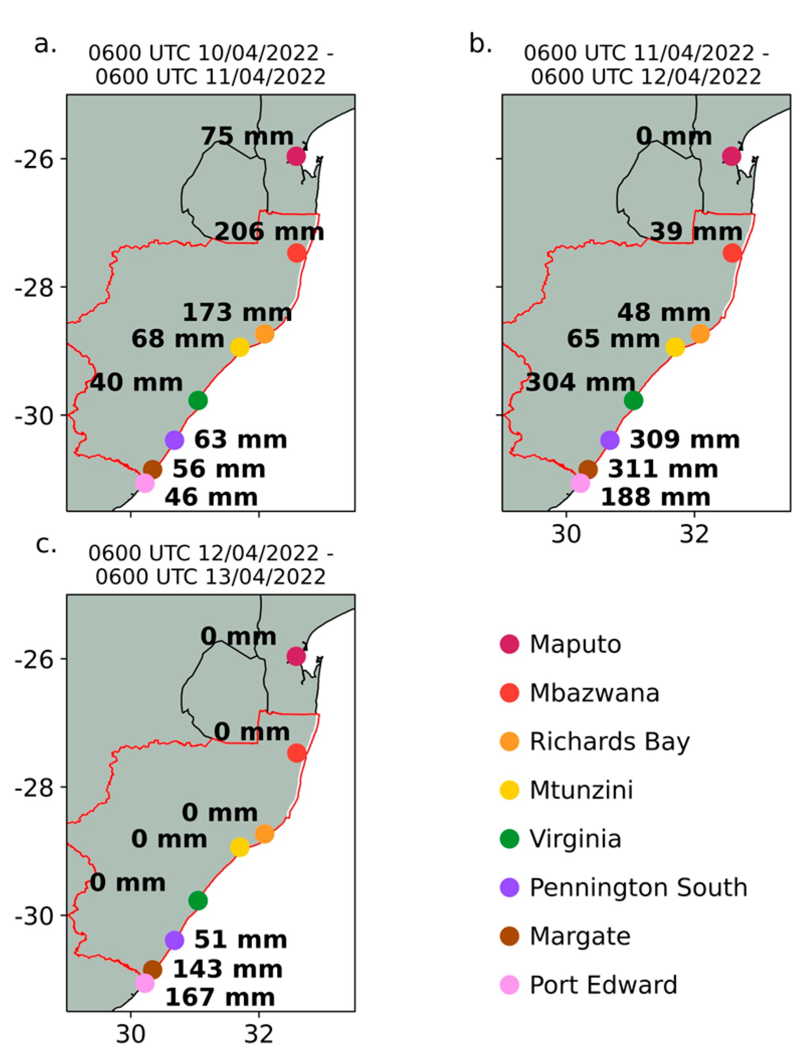
On 10–12 April 2022, heavy rain associated with a cut-off low (COL) fell over parts of KZN and the Eastern Cape (see Figure 1 for main place names and geographical setting), causing devastating flooding within the region. The heaviest rainfall was recorded along the south coast of the KZN province, where 24 h rainfall exceeded 300 mm at some stations (Figure A1 in Appendix A). Although the topographic gradient between the coast and the inland mountains being much tighter in the south than the north may have played a role in the precipitation differences, it is shown below that the evolution and interaction of two mesoscale systems near the coast were very important in influencing the coastal rainfall patterns. With coastal KZN’s annual rainfall average of about 800–1000 mm [1,2], the amounts recorded equate to ~30% of the annual mean falling over a period of two days. Most of this rainfall occurs during the austral summer where January is the wettest month on average while the April mean rainfall along the coast is ~60–70 mm. Based on ERA5 rainfall data (1979–2022), KZN experienced a standardised rainfall anomaly of 4.3 in April 2022 (the next wettest was 1.3). Flooding associated with this rainfall event resulted in the displacement of over 40,000 people, more than 500 deaths, and reports of dozens of missing people. The catastrophic damage to regional infrastructure led to a power, water and food not being available to many residents during and after the flooding. Many areas in the province also suffered extensive property losses, including the washing away of roads, destruction of bridges, and massive damage to around 12,000 homes [3]. Thus, a national state of disaster was declared a few days after the event in response to the flooding [4].
While this was an extreme rainfall event, it was by no means unprecedented. Historical records [5] indicate similar or even greater amounts on daily rainfall have fallen in coastal KZN on several occasions in the last two centuries (1848, 1856, 1868, 1893, 1905, 1917, 1959). In September 1987, KZN received up to 800 mm of rain, the rough equivalent of its coastal annual average, over a duration of just 5 days with the widespread flooding and associated landslides resulting in more than 500 deaths as well as the displacement of tens of thousands of people [6]. Another heavy rainfall event occurred in April 2019, during which daily rainfall amounts of over 100 mm were recorded at several KZN weather stations, with the highest exceeding 200 mm [7]. Flooding and landslides led to the displacement of up to 1000 people and 80 deaths [8]. As in April 2022, these heavy rainfall events were linked to COLs moving over the region [6,7]. Elsewhere in coastal South Africa, COLs have led to devastating floods in the past such as the southeast coast near East London in August 2002 [9], the south coast in March 2003 [10], and the southeast coast near Port Alfred in October 2012 [11]. The September 1987 case over KZN also resulted from a COL [12].
Although many of these flooding disasters may be associated with COLs, there are other weather systems which have caused severe flooding in KZN. One of the most infamous was Tropical Storm Domoina in late January/early February 1984. This storm, together with Tropical Storm Irina in March 2012, rank within the top 20 extreme precipitation events over northern KZN [13]. Tropical temperate troughs or tropical-extratropical cloud bands can also produce very heavy rainfall on occasion over South Africa [14,15] and, in general, contribute about 28% to the annual rainfall over KZN itself [1] with another 24% resulting from westerly waves/COLs [1,16]. Over northern KZN, tropical lows are the main contributor to extreme precipitation events during the summer half of the year, with cloud bands and COLs making roughly equal contributions but with the latter almost always in October or November and cloud bands more evenly distributed through the summer [13]. The remainder result from mesoscale convective systems (MCS), often developing downstream of the Drakensberg mountains before moving eastwards over the province [17,18,19].
COLs typically occur during austral autumn over subtropical southern Africa but have been found to produce heavy rainfall over KZN mostly during early summer [6,13,20]. In this respect, the floods of April 2022 are slightly unusual. Another interesting aspect of this event is that it occurred during a protracted La Niña episode (2020–to date, [21]) at a similar time to COL-related flood events on the east coast of Australia. Over the Indian Ocean, protracted ENSO events are known to have different circulation and sea surface temperature (SST) characteristics to canonical ENSO events [22] while COL occurrences tend to be more common during La Niña years than in other years [20,23]. In particular, SST along the KZN coast during April 2022 was warmer than typically occurs during La Niña, and hence favourable for increased rainfall under onshore wind conditions [24].
Although the synoptic circulation during the April 2022 event involved a COL, the objective in this study is to show how two important mesoscale systems near the KZN coast and their interactions led to the spatial and temporal variability of the heavy rainfall along the KZN coast. These mesoscale systems are a mesoscale convective system (MCS) and a coastal meso-low which later strengthened to form Subtropical Depression Issa. The timing of the evolutions of these two mesoscale features and their interactions determined the strength and location of the onshore moist low-level jet towards the KZN coast and associated low-level moisture flux convergence which progressively moved southwards during 10–12 April, thereby determining the locations of the heaviest rainfall on these days. The mesoscale analysis presented below then allows to understand the temporal and spatial variability of the heavy rainfall along the coast from Maputo southwards along the KZN coast to the Eastern Cape province of South Africa.

2. Datasets and Methods

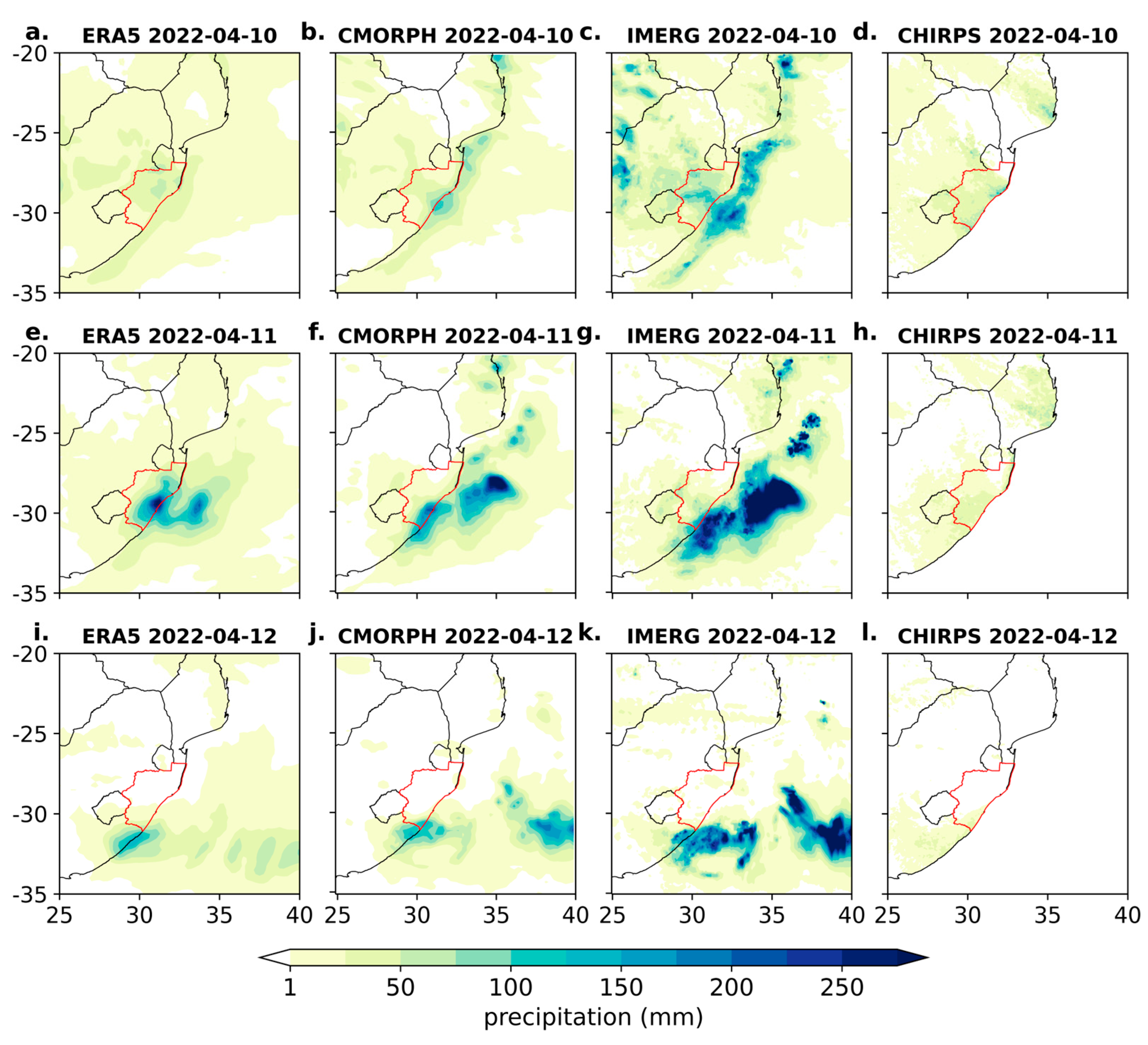
To determine the temporal variability of the heavy rainfall along the coast, 3-hourly accumulated precipitation were constructed using hourly total precipitation data 0.25   resolution from European Centre for Medium-Range Weather Forecast’s Reanalysis v5, ERA5 [25]. In addition, daily station rainfall data during 10–12 April 2022 were obtained from the South African Weather Service (SAWS) and Mozambique National Meteorology Institute (INAM). ERA5 rainfall data were found to be more consistent with the daily rain gauge data than either CHIRPS [26], which very much underestimated the amounts throughout coastal KZN during the event, or CMORPH Climate Data Record (CDR) [27], which tended to underestimate the amounts in northern KZN on 11 April (Figure A2). Synoptic and mesoscale weather conditions during the period were analysed at 3-h intervals from ERA5 horizontal wind, vertical velocity, geopotential height, and specific humidity. Moisture fluxes were calculated from the product of the specific humidity with the horizontal wind vector. The same fields were plotted (not shown) using 3-hourly 0.25° resolution NCEP Global Forecast System (GFS) data [28] and were found to be consistent with the ERA5 results. Daily anomalies in sea surface temperature and surface latent heat flux were determined using NOAA’s Optimal Interpolation SST, version 2 (OISSTV2) [29] and ERA5 datasets, respectively.
The NOAA Hybrid Single-Particle Lagrangian Integrated Trajectory model (HYSPLIT) [30] was used compute backward trajectories for air particles over several stations along coastal south-eastern Africa using gridded meteorological data from ERA5 having a temporal and spatial resolution of 6 h and 0.25°, respectively. Since the stations are located on the coast, particle trajectories were initialised at 250, 500, 750, and 1000 m above ground level at 0600, 1200, and 1800 UTC (11 April 2022) and 0000 UTC (12 April) and tracked backwards for 8 days (196 h), the average global residence time of water vapour in the atmosphere [31]. The trajectory frequency was calculated as the percentage of trajectories passing through a grid cell. Changes in the specific humidity of particles per hour were used to estimate regions of moisture uptake or loss. The identification of trajectory patterns and areas of moisture uptake and/or loss along trajectories typically emphasize the relative importance of various moisture sources for rainfall. In this case, trajectory analysis confirms the importance of moisture uptake over the ocean immediately east of the KZN coast which is then transported by the low-level jet to where the heavy rain occurred.

3. Results

3.1. Synoptic Setting

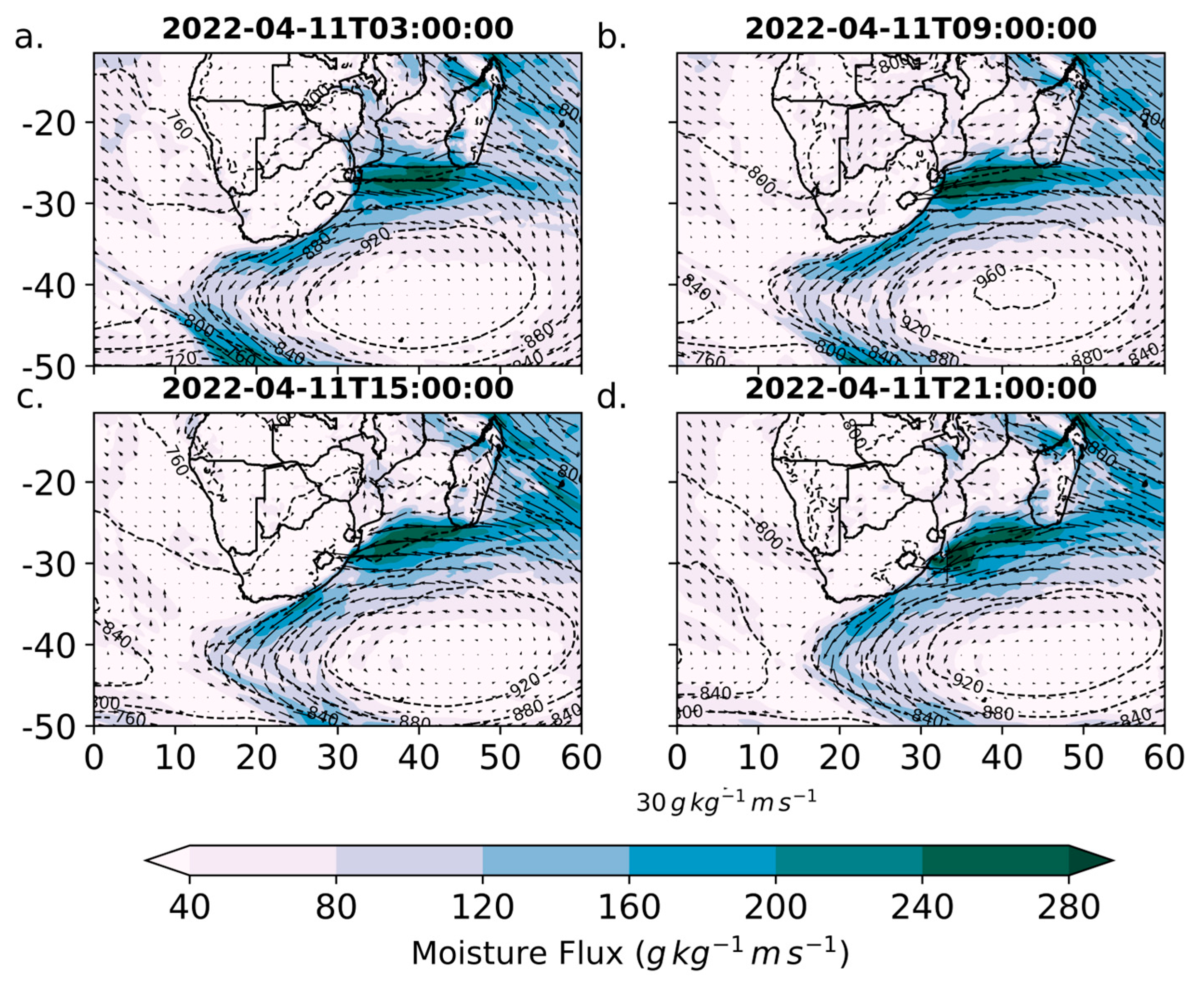
Figure 2a shows that at 0300UTC April 11, the COL was located over the western interior of South Africa with a centre near 30° S, 25° E. The system had formed over 24 h earlier further to the northwest and was centred near 27° S, 22° E in the early hours of 10 April (not shown). At 0300 UTC April 11, there was strong mid-level moisture flux on the eastern flank of the COL and extending over northern KZN/southern Mozambique and over the northern Agulhas Current where the MCS (discussed in the next section) developed. The near-surface flow was dominated by a strong anticyclone to the southeast of South Africa which by 0300UTC 11 April was centred near 40° S, 40° E (Figure 3a). The very large spatial extent of this system meant that the low-level easterly flow towards southern Mozambique and the KZN coast originated from the subtropical South Indian Ocean near 60° E. As shown later, this long easterly fetch led to anomalously high latent heat loss off the South West Indian Ocean which contributed to the strong easterly low-level moisture fluxes evident in Figure 3.
During the next 15 h, the COL intensified and slowly drifted east-southeastwards towards Lesotho (Figure 2b–d). The largest moisture fluxes were apparent throughout the period on the eastern flanks of the COL and extending over KZN and the neighbouring ocean. This mid-level moisture flux not only moved southwards, but also became confined to the KZN coast by 1500UTC April 11 (Figure 2c) and may have contributed towards the development of the meso-low (discussed in the next section) while the surface anticyclone slowly moved eastwards and became slightly more oriented in a southwest-northeast direction rather than more zonally oriented as at 0300 UTC (Figure 3a). As a result, low-level easterly moisture flux towards the coast continued through the remainder of April 11 (Figure 3b–d) but moved ever further southwards. For example, at 0300 UTC, the maximum flux was located near the KZN / Mozambican border (Figure 3a) whereas by 2100 UTC that day, the maximum moisture flux was located further south near 30–31°S (Figure 3d). By comparison with April climatological moisture fluxes in this region [32], the near-surface fluxes in Figure 3 are several times stronger than the mean but, more importantly, show a long easterly fetch, whereas the mean flow is southeasterly up towards the central Mozambican coast rather than directly onshore towards the KZN coast as in Figure 3. Moreover, by 1500 UTC April 11, coastal meso-troughing is also evident along the northern KZN coast (Figure 3c). This feature, along with the MCS already mentioned, is key to understanding the evolution of the heavy rainfall along the KZN coast and is analysed in detail in the next section.

3.2. MCS and Meso-Low Interactions and Rainfall Timing

A key feature of the flooding is the progression of heavy rainfall down the coast during 10–12 April from Maputo to the far south coat of KZN/Eastern Cape. In this section, evidence is presented that indicates that the southward movement of the region of heaviest rainfall is related to the interaction of an MCS offshore of Maputo with a coastal meso-low. The former tracked southeastwards and further offshore while the meso-low strengthened and moved polewards down the KZN coast, before eventually evolving into Subtropical Depression Issa. Interaction between the MCS and the meso-low determined the region of strongest low-level moisture convergence/uplift on the coast at particular times and how this moved southwards, thereby influencing the rainfall.
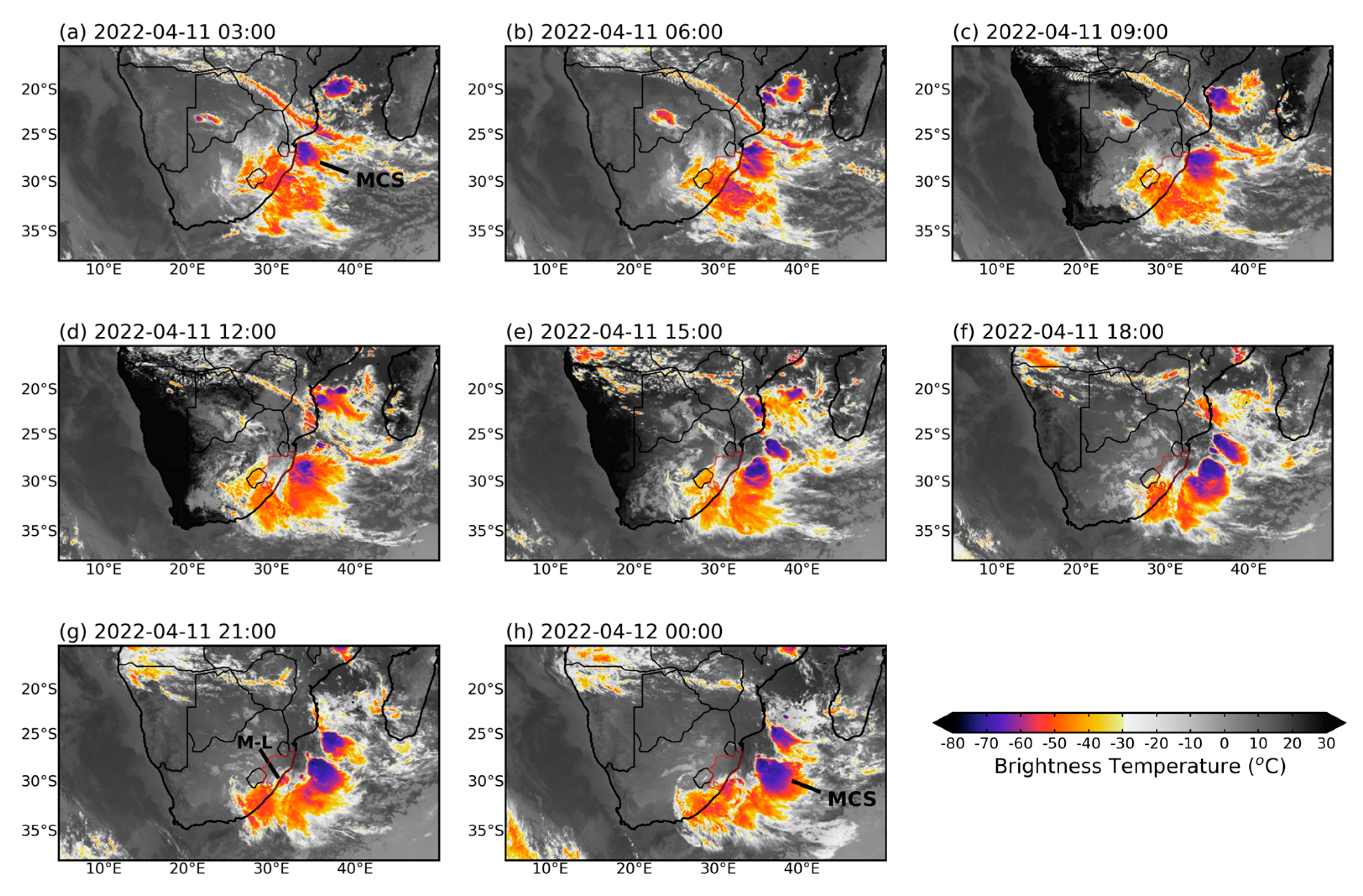
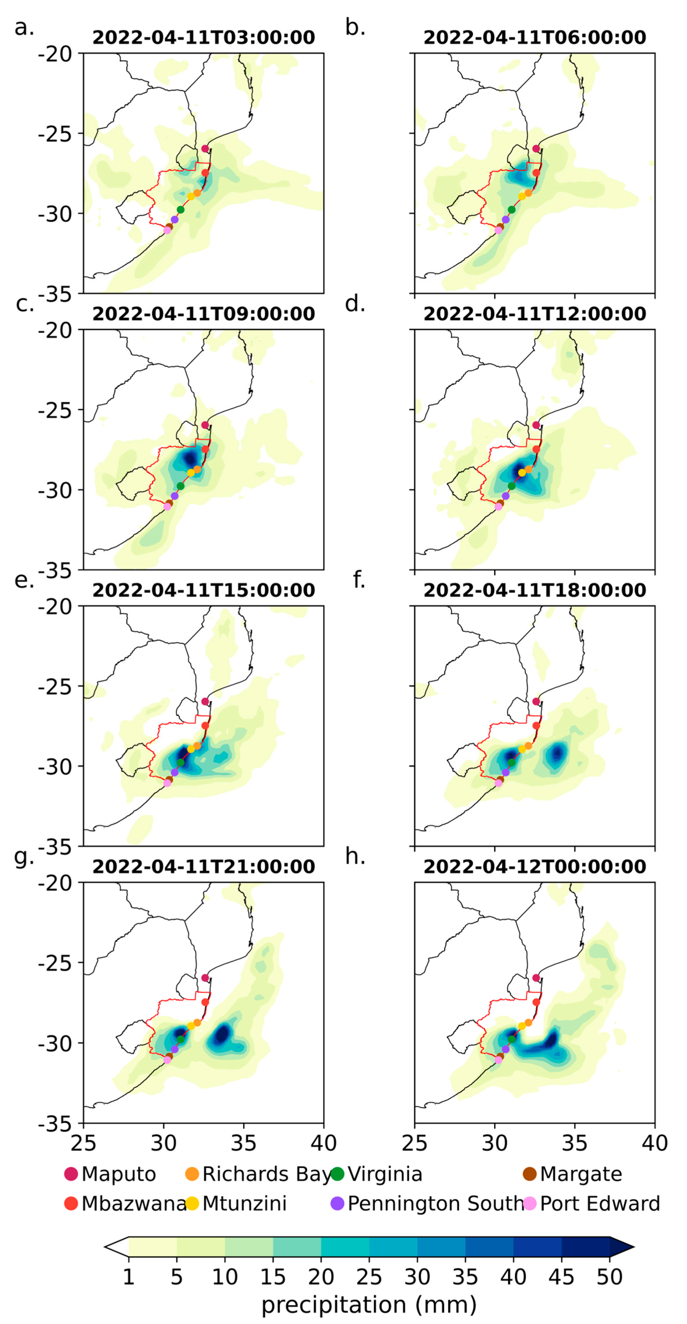
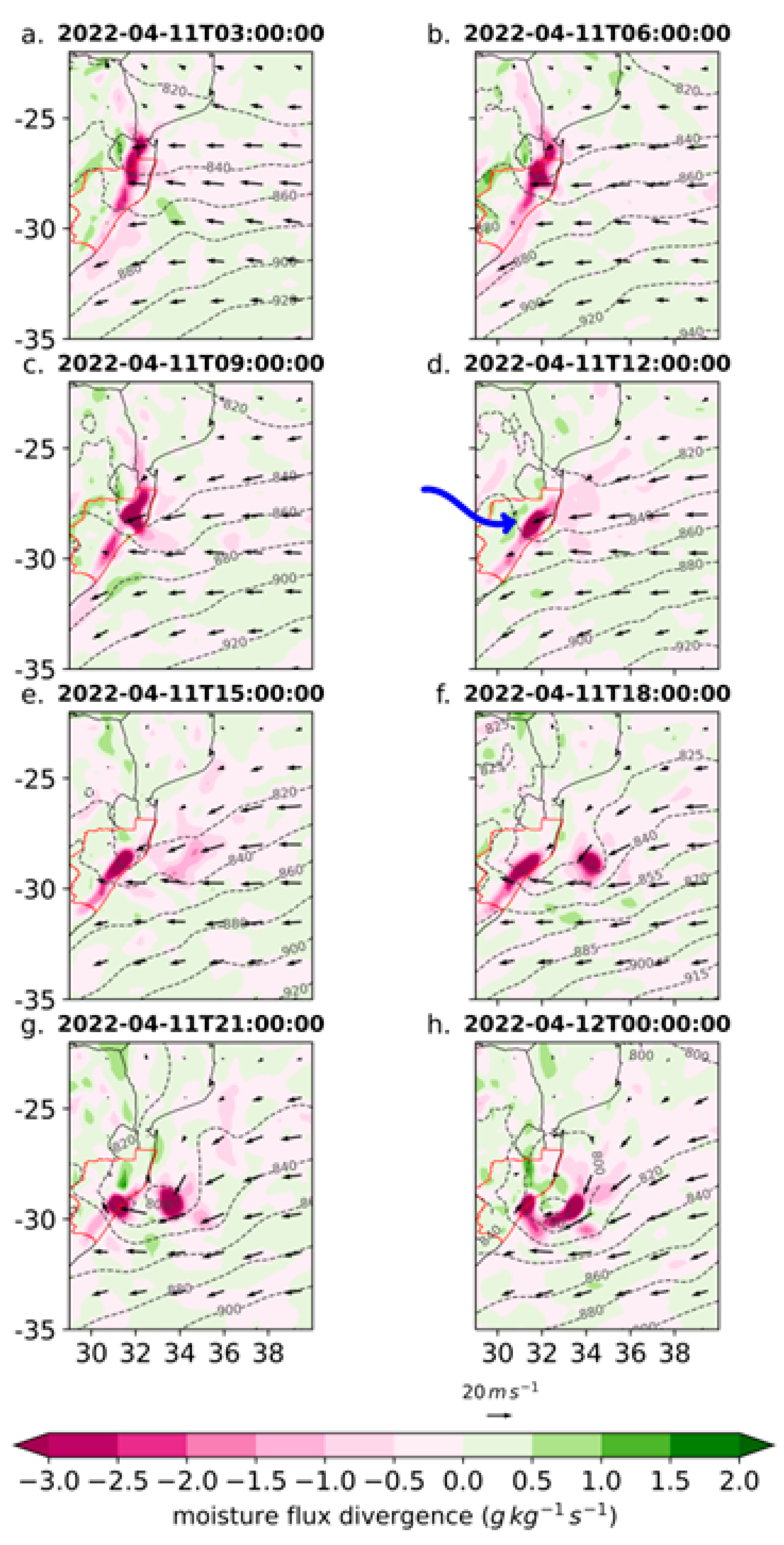
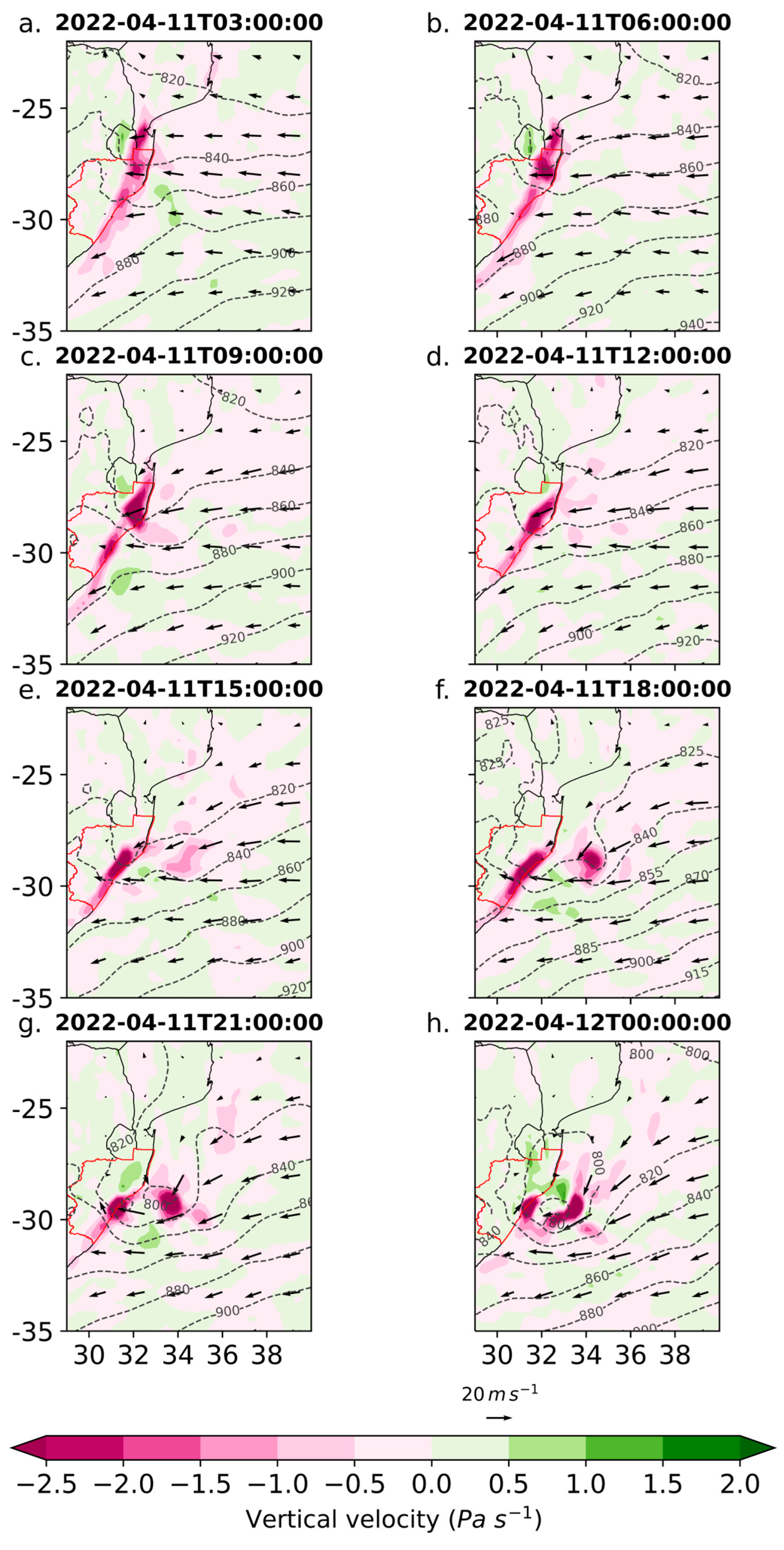
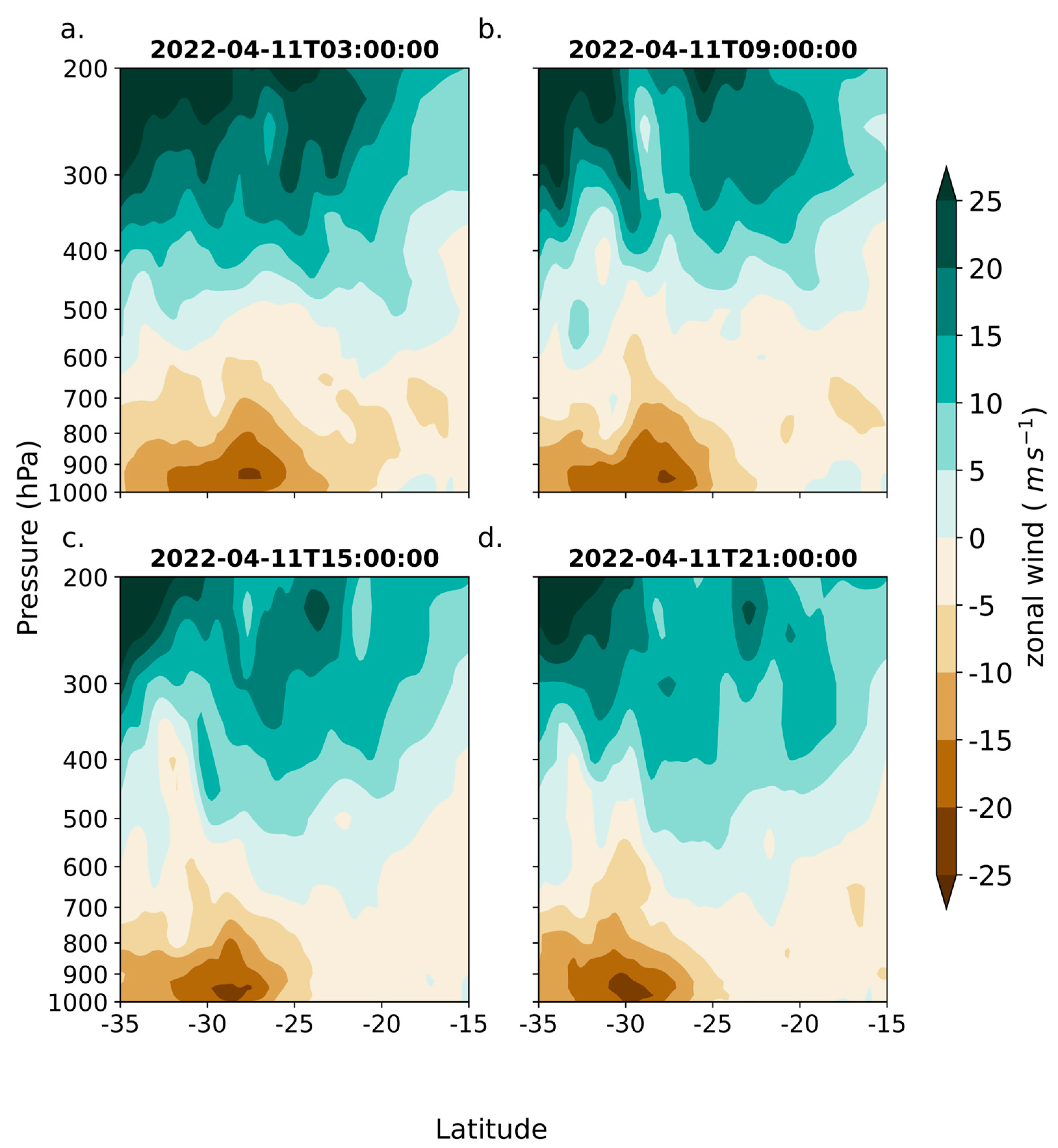
Figure 4a indicates that the MCS was present by 0300UTC April 11 over the northern Agulhas Current just offshore from Maputo. “First storms” prior to MCS initiation occurred at around 00UTC (not shown). On average, about 2 MCS form over the northern Agulhas Current/Maputo region in April with peak occurrence here in November/December and with 0300UTC being a typical initiation time [19]. Figure 5a shows that most of KZN and southern Mozambique were receiving rainfall at 0300UTC with the heaviest falls stretching from the coast near Mbazwana, where the southwestern edge of the MCS was located, inland to a band near the KZN/Mozambican/Eswatini border which matches up with strongest low-level moisture convergence (Figure 6a) and uplift (Figure 7a). The COL was centred over central South Africa near 30° S, 25° E at this time (Figure 2a) with its downstream upper-level westerly flow splitting over the northern Agulhas Current. A zonal wind transect along 36° E (a few hundred km seawards of the northern KZN coast) indicates upper level westerly wind maxima near 30° S and 25° S, on the southern and northern edges of the MCS respectively (Figure 8a), producing upper-level divergence (not shown), favourable for deep convection there. Maximum low-level onshore winds (>20 ms−1) are evident near ~27–28° S (i.e., offshore of Mbazwana). Note that the KZN coast bends substantially southwestwards polewards of ~28° S, so the transect along 36° E is much further offshore at higher latitudes, and that the south coast of South Africa lies at ~34° S.
Over the next 3 h, the MCS expanded and shifted slightly further south along the northern KZN coast (Figure 4b). The rainfall pattern was similar but now much heavier in the region extending from the coast between Mbazwana and Richards Bay towards the interior (Figure 5b) where there was ongoing strongest low-level convergence (Figure 6b) and uplift (Figure 7b). Note that this convergent/uplift region had shifted slightly further south compared to 0300UTC. Some meso-troughing was now apparent on the coast near the KZN/Mozambican border.
At 0900UTC, the MCS strengthened and remained close to the northern KZN coast but again shifted slightly further south (Figure 4c). Rainfall stretching from the coast near Richards Bay northwestwards towards eSwatini was now considerably greater than earlier (Figure 5c), matching up with the strongest areas of low-level convergence (Figure 6c) and uplift (Figure 7c) with meso-troughing evident along the coast from Maputo to Richards Bay (Figure 6c).
Between 0900 and 1200 UTC, the band of heaviest rainfall contracted towards the KZN coast near, and south of, Mtunzini (Figure 5d) as the corresponding band of strongest low-level convergence and uplift (Figure 6d and Figure 7d) also moved slightly coastwards. Meanwhile, the MCS remained close to the north coast but moved slightly further south (Figure 4d) as did the coastal meso-trough which had also strengthened (Figure 6d) in the vicinity of Mtunzini (~29° S).
A clear change in MCS position occurred over the next 3 h with the system now clearly located offshore as well as being stronger than earlier and further polewards (Figure 4e). Resulting from this offshore shift in the MCS, the onshore flow (Figure 8c) strengthened along 36° E which is now >25 ms−1 at latitudes corresponding to the central and south KZN coasts. Figure 6e indicates that the onshore winds weaken as they impact the central coast but are still ~ 20 ms−1. Such low-level jets crossing the Agulhas Current have been previously implicated in COL-associated flood events further south near East London (Eastern Cape) [9] and near Riversdale in Western Cape [10]. As the MCS tracked southeastwards and the low-level jet strengthened, the low-level convergence/uplift became stronger over the central and southern KZN coast by 1500 UTC (Figure 6e and Figure 7e) with a tightening of the meso-trough near Mtunzini and a weakening of the convergence/uplift over the north coast. Consistent with these changes, the rainfall pattern now shows the maximum shifted further south on the coast between Mtunzini and Virginia with much less rainfall further north (Figure 5e). At the same time, a secondary maximum in rainfall, convergence, and uplift can be seen offshore near 33–34° S beneath the western half of the MCS. Note that a second, and smaller MCS, develops near 26° S, 35° E and then drifts slowly towards the Mozambican coast near 23° S over the next 15 h, before dissipating around 0600UTC April 12. Since it does not appear to directly influence the KZN flooding event, it is not discussed further.
As it tracked slowly southeastwards through to 1800 UTC, further strengthening of the MCS is apparent (Figure 4f) which leads to a clear separation in the offshore rainfall maximum (near 34° E) from that at the central KZN coast near Virginia (Figure 5f). Similarly, two clear maxima in low-level convergence and uplift are evident (Figure 6f and Figure 7f). North of Richards Bay, the convergence and uplift were now very weak, and hence the rainfall here became light. The offshore and southward track of the MCS played a key role in weakening the onshore flow towards northern KZN coast but strengthening it towards the central coast where it helped enhance the meso-trough. Onshore winds impacting the central and southern coasts are noticeably stronger than 3 h earlier (Figure 6f).
By 2100UTC, a coastal meso-low had formed (Figure 6g) between the offshore MCS (Figure 4g) and the coastline with distinct rainfall maxima either side of it (Figure 5g). The meso-low can be seen in the small area of cold brightness temperature right on the KZN coast near 29° S. Areas of strong low-level convergence and uplift extended southwestwards along and slightly inland of the coast (Figure 6g and Figure 7g) leading to heavy rainfall from Virginia south to Pennington South as well as inland. The onshore winds around the southern edge of the meso-low and impacting the south coast strengthened to ~25 ms−1 (Figure 6g). Over the interior, the COL had tracked eastwards with the downstream upper-level westerly flow now splitting further south over the Agulhas Current than before as the MCS continued to move southeastwards. The westerly outflow from the COL centred just west of Lesotho near 30–31° S (Figure 2d) produced the large area of warmer, stratiform cloud (Figure 4g) extending southeastwards from Lesotho over southern KZN/northern Eastern Cape province which likely contributed to the inland rainfall seen in Figure 5g. Meanwhile the northern KZN coast and adjacent interior were now dry under a regime of weak divergence and subsidence.
Figure 4h suggests that the MCS reached its greatest strength and extent (cloud top temperatures < −60 °C stretching over > 100,000 km2) around 00UTC April 12 where the upper-level westerly flow downstream of the COL had split the most (not shown). Meanwhile, the coastal meso-low strengthened and moved slightly offshore with the previous distinct maxima in rainfall (Figure 5h), low-level convergence, and uplift (Figure 6h and Figure 7h) now forming a continuous semi-circular band which stretched from the coast near Virginia-Mtunzini around to the seawards edge of the meso-low.
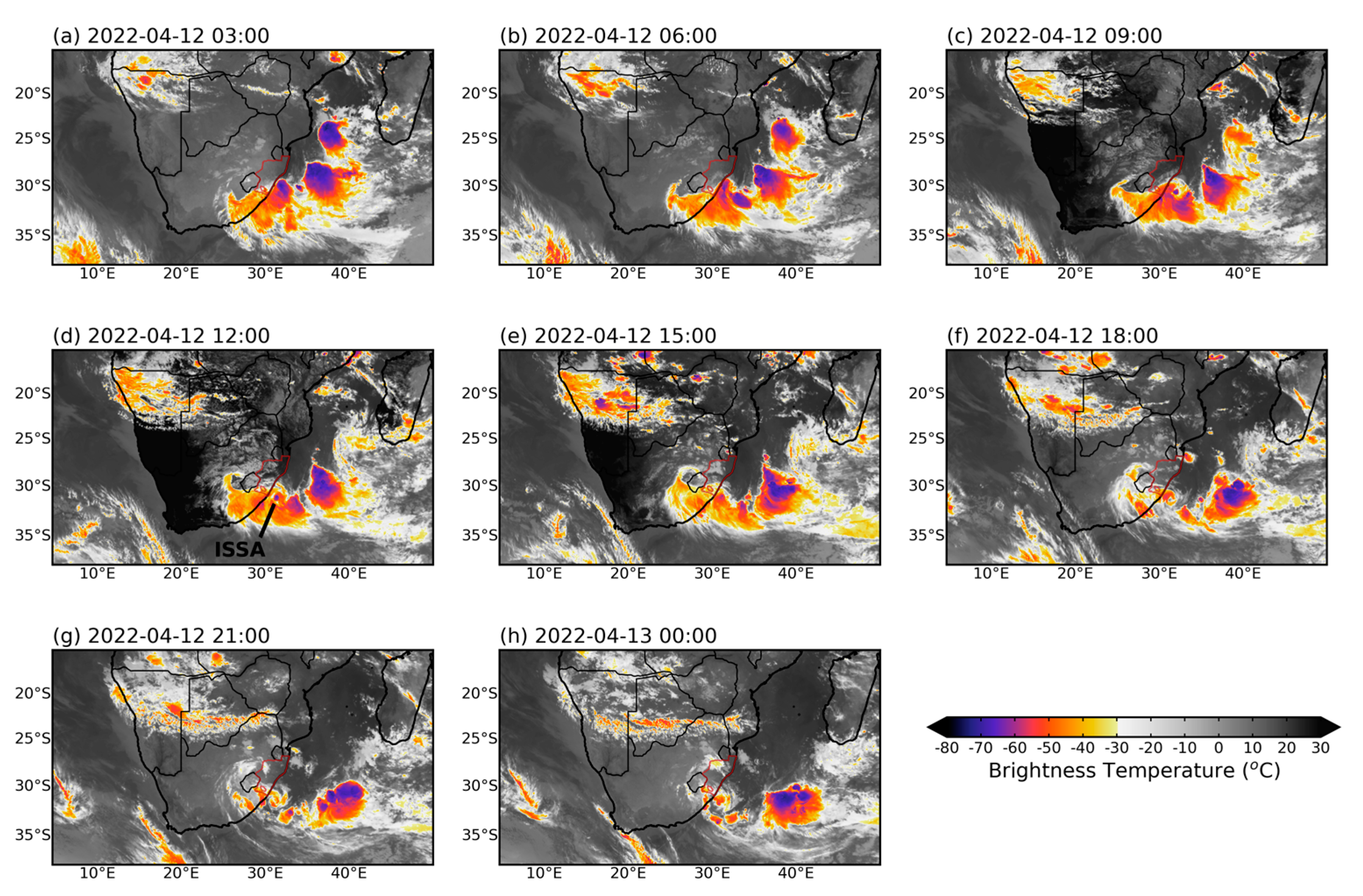
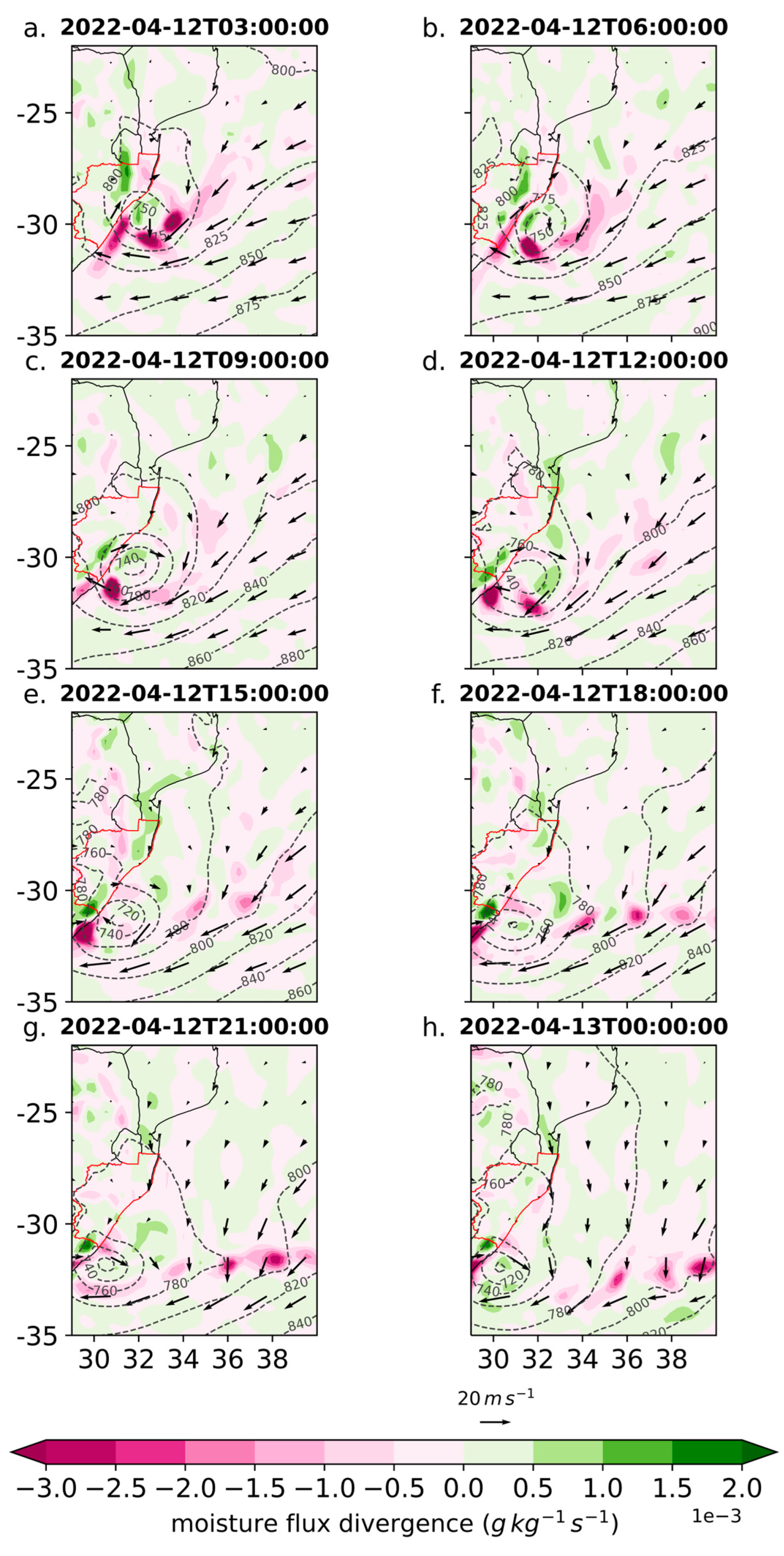
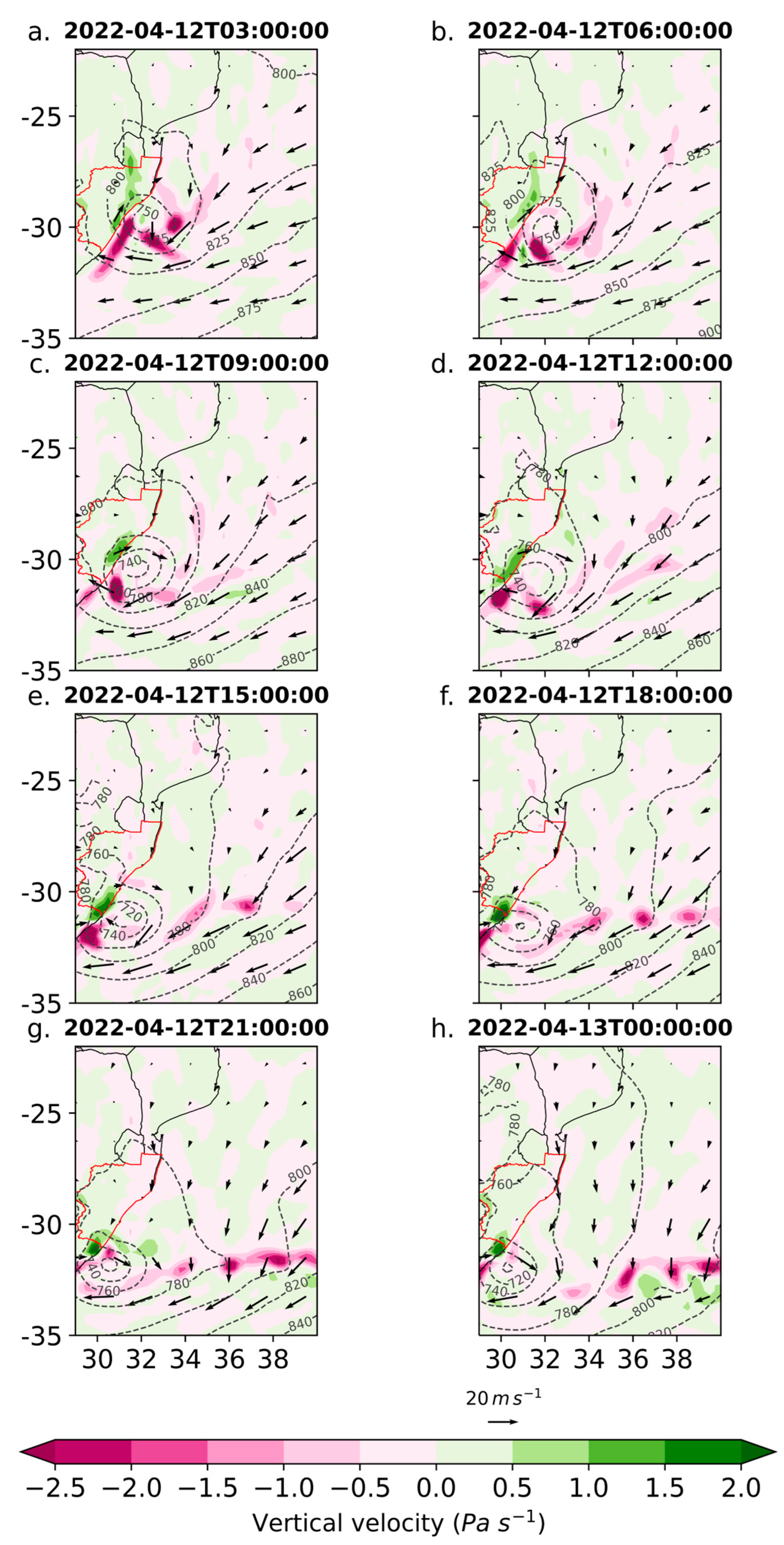
Over the next 6 h to 0600UTC April 12, the coastal meso-low strengthened (with winds around its southern edge of 25–30 ms−1) and moved very slightly southwards while the MCS moved a bit further to the east and weakened (Figure A3a,b). As a result, the semi-circular band of strongest low-level convergence/uplift on the southern half of the low broke up into separate maxima again (Figure A3 and Figure A4a,b). The most intense rainfall (Figure A4a,b) was now evident just offshore of Port Edward on the southern edge of the meso-low where convective cloud was evident (Figure A3a,b). This convective activity associated with the meso-low appeared to also be interacting with the outflow from the COL as that upper-level flow split over the central Agulhas Current region, creating upper-level divergence (not shown), favourable for convection. Heavy falls also occurred along the coast from a point about 50 km south of Port Edward northwards to Pennington South.
This situation continued through to 1200UTC April 12 with the meso-low strengthening further and hugging the southern KZN coast (Figure A3c,d). To its eastnortheast, the MCS moved slightly further out into the South West Indian Ocean and strengthened. At this time, the intensity of the coastal low and its low-level winds warranted it being formally named Subtropical Depression Issa by Meteo France Reunion (MFR), its central pressure was 997 hPa with maximum sustained 10 m winds of 40 kt (20.6 ms−1) near 30.8° S, 31.6° E (about 50 km offshore from Margate). Heavy rainfall over land was confined to the northern coast of the Eastern Cape where the strongest low-level moisture convergence and uplift were evident (Figure A4 and Figure A5c,d). Little or no rainfall occurred along the KZN coast (Figure A4c,d).
By 1800UTC April 12, Issa deepened to a central pressure of 994 hPa near 31.3°S, 31.1°E with maximum average winds of 50 kt (25.5 ms−1) while tracking southwestward to lie closer to the coast. As a result, heavy rain (Figure A4e,f) continued at the Eastern Cape coast south of Port Edward as well as offshore around the southern half of Issa and onwards in a band over the ocean to where there were continuing heavy falls near the MCS centred near 34–35° E (Figure A3e,f). These rainfall patterns matched with the areas of strongest low-level moisture convergence/uplift on the northern coast of the Eastern Cape and over the ocean (Figure A4, Figure A5 and Figure A6e,f). Over the next 6 h, Issa slowly drifted south along the coast and intensified (Figure A4 and Figure A5g,h) with heavy rainfall on the Eastern Cape coast near 32° S as well as in a band over the ocean to the MCS (Figure A3g,h). By 0600UTC 13 April, Issa reached a central pressure of 986 hPa near 31.7° S, 30.3° E (about 40 km offshore of Port St Johns in the northern Eastern Cape province) after continuing its southwestward track. Maximum sustained winds had weakened to 45 kt (23 ms−1) according to MFR. The final advisory issued by MFR at 1200UTC April 13 indicated that the system had now moved northeastward and out to sea as well as filled to 996 hPa near 30.1° S, 31.1° E (maximum sustained winds of 35 kt, 17.9 ms−1). Thereafter, the system weakened further.
In summary, the progression of the heavy rainfall from the northern coast of KZN early on 11 April to the central and then south coasts during the period through to the morning of 12 April can be tied to the locations and timings of two mesoscale weather systems and their interactions; namely a MCS and a coastal meso-trough which subsequently deepened to form Subtropical Depression Issa. Initially, the MCS dominated on the 11th with heavy rain only in the north. By midday on the 11th, coastal meso-troughing was clear and interactions between this feature and the MCS, positioned over the northern Agulhas Current, determined where strongest areas of low-level onshore wind, moisture flux convergence, uplift and rainfall occurred. These increasingly shifted southwards down the coast once the meso-low formed and the MCS had tracked offshore later on the 11th. These interactions continued through the 12th with the meso-low strengthening to named status (Issa) by midday as it moved south from the northern to the central Agulhas Current beneath the region of strong upper-level flow splitting downstream of the COL. A strong low-level jet (Figure 8) towards the south coast of KZN, emanating from southeast of Madagascar due to the ridging anticyclone (Figure 3), was further enhanced by the MCS circulation, thus providing favourable conditions for Issa to form over the warm waters of the Agulhas Current. During the period of the storm, SST near the south KZN coast was ~25–26 °C, or ~0.5–1 °C above average, but with an even larger positive SST anomaly to the southeast (Figure 9a,c,e). The long fetch of the onshore flow originating southeast of Madagascar was associated with a band of much higher latent heat loss than average from the ocean surface (Figure 9b,d,f), which ends near the southern margins of Issa itself. Mean April latent heat fluxes are >150 Wm−2 in the Agulhas Current and in the South East Madagascar Current, and ~100–150 Wm−2 over the Mozambique Channel and the open ocean areas south of Madagascar [32]. A schematic summarising the key mesoscale features during this event is given in Figure 10.
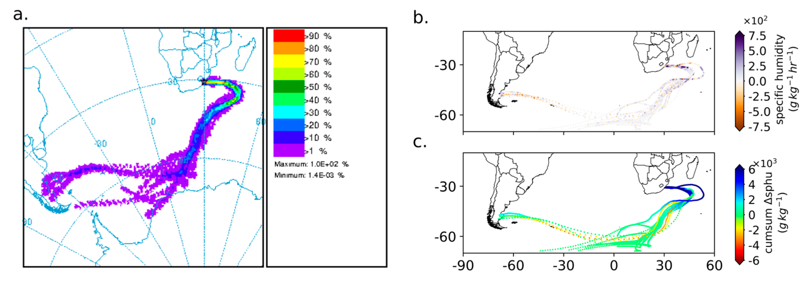
Backward trajectory frequency maps (Figure 11a) using the HYSPLIT model [30] for air particles released at coastal stations on 11th April showed that up to 80% of trajectories tracked through the region of enhanced latent heat loss between the KZN coast to south of Madagascar. Along this easterly trajectory path, an increase in specific humidity of air particles over this area implies substantial moisture uptake before reaching coastal KZN (Figure 11b). The anomalies in Figure 9d,e,f imply that the low-level onshore flow towards the KZN coast led to roughly a doubling in the latent heat loss compared to average, helping to fuel the MCS and Issa storms, leading to the very heavy rainfall along the coast. Furthermore, the results indicated that the combination of the MCS offshore and the development of the meso-low into Issa close to the coast played key roles in the differences in the timing and duration of the heavy rains along the KZN coast during 10–12 April.

4. Discussion

Given the spatial resolution of the available data, it is not possible to determine exactly how the coastal meso-trough first formed around 0600 UTC April 11 on the far northern KZN coast. The easterly flow towards the coast was blowing over warm water (26–27 °C) extending from the surface to near 700 hPa (Figure 8a,b). Pseudo-soundings (not shown) for Maputo and Mbazwana indicated an unstable layer extending up to mid-levels, above which the air was relatively cool and dry. Thus, conditions were favourable for the formation of the meso-trough over these warm coastal waters. MM5 sensitivity experiments have shown that coastal near-surface lows off the southeast or south coasts of South Africa during previous COL events do not occur when the Agulhas Current is smoothed out from the model SST forcing field [9,10], highlighting the important contribution of the warm SST in this current.
Above the easterly flow, a relatively strong northerly flow existed in the ~650–550 hPa layer. Figure 3a,b suggest troughing of the large- scale anticyclonic flow near the KZN coast, possibly due to frictional contrasts between the coastal waters and the neighbouring land which rises up to >1000 m within 100–200 km of the coast. The 925 hPa flow at 0300UTC April 11 (Figure 3) is reminiscent of the weak nocturnal low-level Limpopo jet pattern shown in Figure 7e of [33] where the onshore easterlies divert with some of the flow going northwestward over southern Mozambique and thence into the Limpopo valley between northern South Africa and Zimbabwe, and the rest going south along the northern KZN coast with a relative trough located there.
Regardless of its formation mechanism, once a distinct meso-low formed over the Agulhas Current near 28° S around 2100UTC April 11, the mid-level northerly flow over the Maputo region and adjacent Mozambique Channel helped advect the low southwards down the coast. It may also be suggested that the presence of the MCS to its northeast (Figure 4e–h) prevented the meso-low from moving offshore. Instead, the meso-low intensified over the warm waters of the Agulhas Current which were ~25 °C or above all the way along the KZN coast. The evolution of these two distinct mesoscale features, interactions between them, and how they influenced the positioning of the onshore low-level jet towards the KZN coast were key to understanding the progression of the heavy rainfall down the coast over the two-day period and the resulting floods. To the best of our knowledge, this type of mesoscale interaction between an MCS and a meso-low/subtropical depression has not been previous documented in southern Africa or, more generally, the southern hemisphere.
On several occasions, government officials attributed this devastating flooding event to climate change and described it an unprecedented [3,4]. However, the KZN coast has experienced similar amounts of extreme rainfall over a few days several times since at least 1848, some of which also involved cut-off lows, and which have led to large loss of life and damage. Thus, local and national government should be well aware of the vulnerability of this region to these events. On the other hand, almost all the extended summers (October–March, the main rainy season) have received below average rainfall along the KZN coast after the wet 1999/00 summer through to 2017 (Figure 5 in [34]) with several thereafter also being dry according to the SAWS. Thus, local authorities may have been less cognisant of the possibility of extreme rainfall events than might have been the case had recent years instead experienced well above average rainfall.
It should also be noted that the flood destruction in April 2022 was influenced by non-climate related factors. For example, the geology of certain areas predisposes them to landslides when heavy rainfall occurs [35]. Many urban areas in South Africa suffer from poor municipal planning and lack of maintenance on roads, bridges, and drainage infrastructure which increases their vulnerability to flash flooding. Informal settlements are often forced through severe socio-economic disadvantage to locate themselves in flood-prone areas and, as a result, there was a very high death and injury toll during this event on the local population in the eThekwini metropolitan municipality (~4 million residents) which includes Durban. Future research should consider what socio-economic incentives and development could encourage people to settle away from these flood-prone areas and how various levels of government can work together more efficiently to mitigate the impacts of such events.

5. Conclusions

In this study, evidence has been shown of the importance of interactions between two mesoscale systems on the KZN coast for determining the timing and spatial extent of the extreme rainfall event during 10–12 April 2022. These two systems were a mesoscale convective system (MCS) and a coastal meso-low which later evolved into Subtropical Depression Issa. The large-scale environment was dominated by a cut-off low situated over the interior of South Africa whose mid- and upper level westerly outflow split over the very warm waters of the northern Agulhas Current, leading to upper level divergence, favourable for the development of deep convection over the current in the form of the MCS and later the coastal meso-low strengthening into Issa. At low levels, the strong anticyclone centred well south of Madagascar and with a large zonal extent produced a very long easterly fetch across anomalously warm waters to the KZN coast and hence well-above average latent heat fluxes off the sea surface for this time of year. These large-scale features were then very favourable for the development of heavy rainfall near the coast.
On the mesoscale, the low-level circulation associated with the MCS interacted with the developing coastal meso-low into Subtropical Depression Issa as the former tracked southeastwards (offshore) and the meso-low moved southwards along the coast. These mesoscale interactions and their timings then controlled the positioning and ~550 km southward progression down the coast of the onshore low-level jet, low-level moisture convergence, uplift, and hence the extreme rainfall between 06 UTC April 11 (when it occurred in far northern KZN) and early on April 13 (when it only occurred on the Eastern Cape coast some 550 km further south). To the best of our knowledge, this type of mesoscale interaction has not previously been documented in southern Africa, or the southern hemisphere.
This study has highlighted the crucial roles of the MCS and the coastal meso-low together with their interactions in determining the extreme rainfall. However, very little work has been done on southern African MCSs and this work has focussed on the summer. The results presented here suggest that future research should also consider the transition seasons. In addition, there is a need to better understand the role of the northern Agulhas Current and the local topography in the evolution of coastal meso-lows and under what synoptic conditions these systems are most likely to occur.

Author Contributions

Conceptualization, W.T., R.C.B., and C.J.C.R.; methodology, W.T.; software, W.T.; validation, W.T., formal analysis, W.T.; investigation, W.T.; resources, C.J.C.R.; data curation, W.T. and R.C.B.; writing—original draft preparation, W.T. and C.J.C.R.; writing—review and editing, W.T., R.C.B., and C.J.C.R.; visualization, W.T. and R.C.B.; supervision, C.J.C.R. and R.C.B.; project administration, C.J.C.R.; funding acquisition, W.T., R.C.B., and C.J.C.R. All authors have read and agreed to the published version of the manuscript.

Funding

This research was partially funded by Royal Society (United Kingdom) and African Academy of Sciences, through the FLAIR Programme, grant number FLR\R1\201615.

Institutional Review Board Statement

Not applicable.

Informed Consent Statement

Not applicable.

Data Availability Statement

The ERA5 data used was downloaded from the Copernicus Climate Change Service (C3S) Climate Data Store. Satellite imagery was downloaded from EUMETSAT Data Store (https://data.eumetsat.int (8 June 2022). Station data in this study is available on request from the South African Weather Service (SAWS) (http://www.weathersa.so.za (23 May 2022)). NOAA Air Resources Laboratory (ARL) for the HYSPLIT transport and dispersion model and/or READY website (https://www.ready.noaa.gov (9 May 2022)); NOAA PSL for NOAA Optimum Interpolation (OI) SST V2 data (https://psl.noaa.gov (10 October 2022)); and the USGS for SRTM 1 Arc-Second Global Digital Elevation dataset (https://earthexplorer.usgs.gov/ (17 June 2022)) used in Figure 1.

Acknowledgments

W.T. thanks South Africa’s National Research Foundation and University of Cape Town’s Advancing Womxn Fellowship for funding her PhD studies which are ongoing—this study represents work done during the first year of the degree. R.C.B. acknowledges support of the FLAIR programme, a partnership between the African Academy of Sciences and the Royal Society funded by the UK Government’s Global Challenges Research Fund. The authors thank SAWS for KZN gauge daily rainfall and Bernardino Nhantumbo (INAM) for supplying Maputo gauge daily rainfall data. The authors also thank the four reviewers for the valuable comments that helped improve the paper.

Conflicts of Interest

The authors declare no conflict of interest.

Appendix A

Figure A1. South African Weather Service daily rainfall values for stations within KZN from (a) 10 April 2022; (b) 11 April 2022 and (c) 12 April 2022. Note that the data is accumulated over a 24 h period starting at 0600 UTC on the given day through to 0600 UCT the following day (see title of panel). The data for the Maputo station, which is accumulated from 0700 UTC to 0700 UTC, is provided by INAM.
Atmosphere 14 00078 g0a1
Figure A2. The daily precipitation (shaded; mm) derived from four products, which are ERA5 (panels a,e,i), CMORPH-CDR (b,f,j), IMERG [36] (c,g,k) and CHIRPS (d,h,l) from 10 to 12 April 2022.
Atmosphere 14 00078 g0a2
Figure A3. Brightness temperature (shaded; °C) taken from EUMETSAT Meteosat infrared satellite data at 3 h intervals (from left-hand side to right-hand side) starting at (a) 0300 UTC 12 April 2022 (top left-hand side) through to (h) 0000 UTC 13 February (bottom centre) at 3 hourly intervals. The location of the Subtropical Depression “Issa”, discussed in the text, is highlighted in panel (d).
Atmosphere 14 00078 g0a3
Figure A4. ERA5 precipitation (shaded; mm) accumulated at 3 hourly intervals, shown at (a) 0300 UTC, (b) 0600 UTC, (c) 0900 UTC, (d) 1200 UTC, (e) 1500 UTC, (f) 1800 UTC, (g) 2100 UTC on 12 April 2022 and ending at (h) 0000 UTC 13 April 2022. The locations of the stations discussed in the text are depicted by the coloured circles.
Atmosphere 14 00078 g0a4
Figure A5. ERA5 moisture flux divergence (g kg−1 s−1) and wind speed (vectors; m.s−1) at the 925 hPa pressure level at 3 h intervals at (a) 0300 UCT, (b) 0600 UTC, (c) 0900 UTC, (d) 1200 UTC, (e) 1500 UTC, (f) 1800 UTC, (g) 2100 UTC on 12 April 2022 through to (h) 0000 UCT on 13 April 2022.
Atmosphere 14 00078 g0a5
Figure A6. Same as Figure A5, but for vertical velocity (shaded; Pa s−1) and wind speed (vectors; m.s−1) at the 925 hPa pressure level.
Atmosphere 14 00078 g0a6

References

  1. Diab, R.; Preston-Whyte, R.; Washington, R. Distribution of rainfall by synoptic type over Natal, South Africa. Int. J. Climatol. 1991, 11, 877–888. [Google Scholar] [CrossRef]
  2. Ndlovu, M.; Clulow, A.D.; Savage, M.J.; Nhamo, L.; Magidi, J.; Mabhaudhi, T. An assessment of the impacts of climate variability and change in KwaZulu-Natal Province, South Africa. Atmosphere 2021, 12, 427. [Google Scholar] [CrossRef]
  3. South Africa Government. National State of Disaster in numbers—18 April 2022. Available online: https://www.gov.za/speeches/national-state-disaster-numbers-%E2%80%93-18-april-2022-18-apr-2022-0000 (accessed on 2 November 2022).
  4. South Africa Government. President Cyril Ramaphosa: Declaration of a National State of Disaster to Respond to Widespread Flooding. Available online: https://www.gov.za/speeches/president-cyril-ramaphosa-declaration-national-state-disaster-respond-widespread-flooding (accessed on 2 November 2022).
  5. Grab, S.; Nash, D.J. A new flood chronology for Kwa-Zulu Natal (1836–2022). The April 2022 Durban floods in historical context. In Proceedings of the 36th Annual conference of South African Society for Atmosphere Sciences, Pretoria, South Africa, 30 October 2022. [Google Scholar]
  6. Badenhorst, P.; Cooper, J.; Crowther, J.; Gonsalves, J.; Laubscher, W.; Grobler, N.; Mason, T.; Illenberger, W.; Perry, J.; Reddering, J.; et al. Survey of September 1987 Natal floods. Natl. Sci. Programmes Unit CSIR 1989, 164, 136. [Google Scholar]
  7. Bopape, M.-J.M.; Sebego, E.; Ndarana, T.; Maseko, B.; Netshilema, M.; Gijben, M.; Landman, S.; Phaduli, E.; Rambuwani, G.; Van Hemert, L.; et al. Evaluating South African weather service information on Idai tropical cyclone and KwaZulu-Natal flood events. S. Afr. J. Sci. 2021, 117, 1–13. [Google Scholar] [CrossRef]
  8. BBC. South Africa Floods: Death Toll after Durban Rains Rises to 60. 2019. Available online: https://www.bbc.com/news/world-africa-48036252 (accessed on 2 November 2022).
  9. Singleton, A.; Reason, C.J.C. Numerical simulations of a severe rainfall event over the Eastern Cape coast of South Africa: Sensitivity to sea surface temperature and topography. Tellus A Dyn. Meteorol. Oceanogr. 2006, 58, 335–367. [Google Scholar] [CrossRef]
  10. Singleton, A.; Reason, C.J.C. A numerical model study of an intense cutoff low pressure system over South Africa. Mon. Weather Rev. 2007, 135, 1128–1150. [Google Scholar] [CrossRef]
  11. Pyle, D.M.; Jacobs, T.L. The Port Alfred floods of 17–23 October 2012: A case of disaster (mis) management? Jamba: J. Disaster Risk Stud. 2016, 8, 1–8. [Google Scholar] [CrossRef] [Green Version]
  12. Triegaardt, D.O.; Terblanche, D.E.; van Heerden, J.; Laing, M.V. The Natal Flood of September 1987. In South African Weather Bureau Technical Paper; Weather Bureau, Department of Transport: Pretoria, South Africa, 1988. [Google Scholar]
  13. Mpungose, N.; Thoithi, W.; Blamey, R.C.; Reason, C.J.C. Extreme rainfall events in southeastern Africa during the summer. Theor. Appl. Climatol. 2022, 150, 185–201. [Google Scholar] [CrossRef]
  14. Hart, N.C.; Reason, C.J.C.; Fauchereau, N. Tropical–extratropical interactions over Southern Africa: Three cases of heavy summer season rainfall. Mon. Weather. Rev 2010, 138, 2608–2623. [Google Scholar] [CrossRef]
  15. Hart, N.C.; Reason, C.J.C.; Fauchereau, N. Cloud bands over Southern Africa: Seasonality, contribution to rainfall variability and modulation by the MJO. Clim. Dyn. 2013, 41, 1199–1212. [Google Scholar] [CrossRef]
  16. Taljaard, J.J. Cut-off lows in the South African region. In South African Weather Bureau Technical Paper; Weather Bureau, Department of Transport: Pretoria, South Africa, 1985. [Google Scholar]
  17. Blamey, R.C.; Reason, C.J.C. Numerical simulation of a mesoscale convective system over the east coast of South Africa. Tellus A Dyn. Meteorol. Oceanogr. 2009, 61, 17–34. [Google Scholar] [CrossRef]
  18. Blamey, R.C.; Reason, C.J.C. Mesoscale convective complexes over southern Africa. J. Clim. 2009, 25, 753–766. [Google Scholar] [CrossRef] [Green Version]
  19. Morake, D.M.; Blamey, R.C.; Reason, C.J.C. Long-lived mesoscale convective systems over eastern South Africa. J. Clim. 2021, 34, 6421–6439. [Google Scholar] [CrossRef]
  20. Singleton, A.T.; Reason, C.J.C. Variability in the characteristics of cut-off low pressure systems over subtropical southern Africa. Int. J. Climatol. 2007, 27, 295–310. [Google Scholar] [CrossRef]
  21. WMO. WMO predicts first “triple-dip” La Niña of the century. Available online: https://public.wmo.int/en/media/press-release/wmo-predicts-first-%E2%80%9Ctriple-dip%E2%80%9D-la-ni%C3%B1a-of-century (accessed on 2 November 2022).
  22. Allan, R.J.; Reason, C.J.C.; Lindesay, J.A.; Ansell, T.J. Protracted ENSO episodes and their impacts in the Indian Ocean region. Deep Sea Res. Part II Top. Stud. Oceanogr. 2003, 50, 2331–2347. [Google Scholar] [CrossRef]
  23. Favre, A.; Hewitson, B.; Tadross, M.; Lennard, C.; Cerezo-Mota, R. Relationships between cutoff lows and the semiannual and southern oscillations. Clim. Dyn. 2012, 38, 1473–1487. [Google Scholar] [CrossRef]
  24. Reason, C.J.C.; Allan, R.J.; Lindesay, J.A.; Ansell, T.J. ENSO and climatic signals across the Indian Ocean basin in the global context: Part I, interannual composite patterns. Int. J. Climatol. 2000, 20, 1285–1327. [Google Scholar] [CrossRef]
  25. Hersbach, H.; Bell, B.; Berrisford, P.; Hirahara, S.; Horányi, A.; Muñoz-Sabater, J.; Nicolas, J.; Peubey, C.; Radu, R.; Schepers, D.; et al. The ERA5 global reanalysis. Q. J. R. Meteorol. Soc. 2020, 146, 1999–2049. [Google Scholar] [CrossRef]
  26. Funk, C.; Peterson, P.; Landsfeld, M.; Pedreros, D.; Verdin, J.; Shukla, S.; Husak, G.; Rowland, J.; Harrison, L.; Hoell, A.; et al. The climate hazards infrared precipitation with stations—A new environmental record for monitoring extremes. Sci. Data 2015, 2, 150066. [Google Scholar] [CrossRef] [Green Version]
  27. Xie, P.; Joyce, R.; Wu, S.; Yoo, S.-H.; Yarosh, Y.; Sun, F.; Lin, R. NOAA CDR Program: NOAA Climate Data Record (CDR) of CPC Morphing Technique (CMORPH) High Resolution Global Precipitation Estimates, Version 1; NOAA National Centers for Environmental Information: Asheville, NC, USA, 2019. Available online: https://doi.org/10.25921/w9va-q159 (accessed on 2 December 2022). [CrossRef]
  28. Whitaker, J.S.; Hamill, T.M.; Wei, X.; Song, Y.; Toth, Z. Ensemble data assimilation with the NCEP global forecast system. Mon. Weather Rev. 2008, 136, 463–482. [Google Scholar] [CrossRef]
  29. Reynolds, R.W.; Smith, T.M.; Liu, C.; Chelton, D.B.; Casey, K.S.; Schlax, M.G. Daily high-resolution-blended analyses for sea surface temperature. J. Clim. 2007, 20, 5473–5496. [Google Scholar] [CrossRef]
  30. Draxler, R.R.; Hess, G. An overview of the HYSPLIT_4 modelling system for trajectories. Aust. Meteorol. Mag. 1998, 47, 295–308. [Google Scholar]
  31. Gimeno, L.; Eiras-Barca, J.; Durán-Quesada, A.M.; Dominguez, F.; van der Ent, R.; Sodemann, H.; Sánchez-Murillo, R.; Nieto, R.; Kirchner, J.W. The residence time of water vapour in the atmosphere. Nat. Rev. Earth Environ. 2021, 2, 558–569. [Google Scholar] [CrossRef]
  32. Mawren, D.; Blamey, R.C.; Hermes, J.; Reason, C.J.C. On the importance of the Mozambique Channel for the climate of southeastern Africa. Clim. Dyn. 2022, 1–21. [Google Scholar] [CrossRef]
  33. Spavins-Hicks, Z.D.; Washington, R.; Munday, C. The Limpopo low-level jet: Mean climatology and role in water vapor transport. J. Geophys. Res. Atmos. 2021, 126, e2020JD034364. [Google Scholar] [CrossRef]
  34. Blamey, R.C.; Kolusu, S.R.; Mahlalela, P.; Todd, M.C.; Reason, C.J.C. The role of regional circulation features in regulating El Niño climate impacts over southern Africa: A comparison of the 2015/2016 drought with previous events. Int. J. Climatol. 2018, 38, 4276–4295. [Google Scholar] [CrossRef] [Green Version]
  35. Bell, F.G.; Maud, R.R. Landslides associated with the colluvial soils overlying the Natal Group in the greater Durban region of Natal, South Africa. Environ. Geol. 2000, 39, 1029–1038. [Google Scholar] [CrossRef]
  36. Huffman, G.J.; Stocker, E.F.; Bolvin, D.T.; Nelkin, E.J.; Tan, J. GPM IMERG Final Precipitation L3 1 day 0.1 Degree × 0.1 degree V06; Savtchenko, A., Ed.; Goddard Earth Sciences Data and Information Services Center (GES DISC): Greenbelt, MD, USA, 2019. Available online: https://disc.gsfc.nasa.gov/datasets/GPM_3IMERGDF_06/summary (accessed on 2 December 2022).
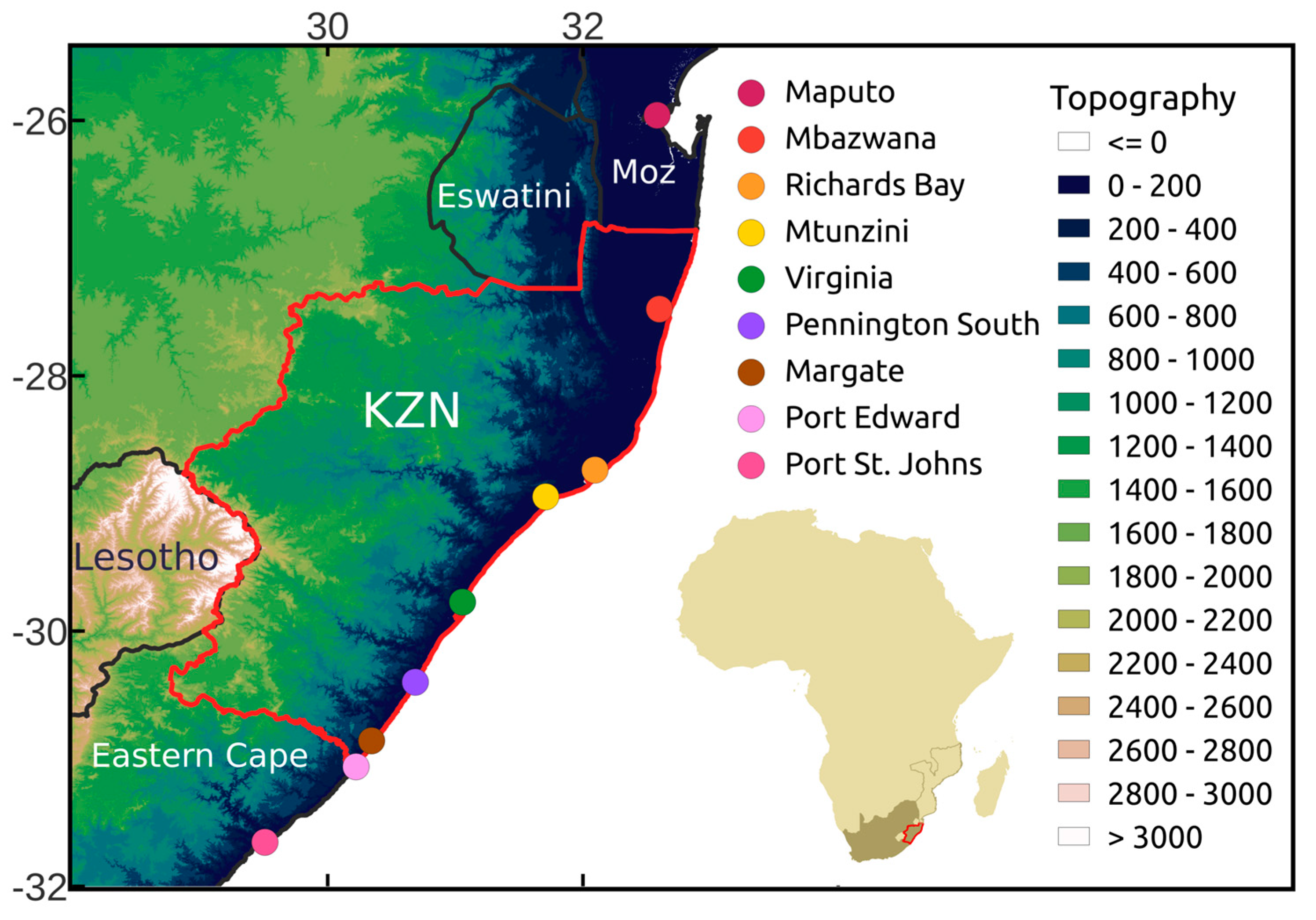
Figure 1. The topography (shaded; m) of the KwaZulu-Natal (KZN) province (red polygon) and surrounding region. The locations referred to in the text are denoted by the coloured circles.
Atmosphere 14 00078 g001
Figure 2. ERA5 geopotential height (contours; m) and moisture flux (vectors; g kg−1 m s−1) at the 500 hPa pressure level at (a) 0300 UTC (b) 0900 UTC (c) 1500 UTC and (d) 2100 UTC on 11 April 2022. Regions with moisture flux exceeding 20 g kg−1 m s−1 are shaded. The position of the COL can be seen in the centre of South Africa in panel (b).
Atmosphere 14 00078 g002
Figure 3. Same as Figure 2, but for the 925 hPa level at (a) 0300 UTC (b) 0900 UTC (c) 1500 UTC and (d) 2100 UTC on 11 April 2022. Here, only regions with moisture flux values exceeding 40 g kg−1 m s−1 are shaded.
Atmosphere 14 00078 g003
Figure 4. Brightness temperature (shaded; °C) taken from EUMETSAT Meteosat infrared satellite data at 3 h intervals (from left-hand side to right-hand side) starting at (a) 0300 UTC 11 April 2022 (top left-hand side) through to (h) 0000 UTC 12 February (bottom centre). The location of the MCS discussed in the text is highlighted in panel (a), while the location of the meso-low is show in panel (g).
Atmosphere 14 00078 g004
Figure 5. ERA5 precipitation (shaded; mm) accumulated at 3 hourly intervals and shown for (a) 0300 UTC, (b) 0600 UTC, (c) 0900 UTC, (d) 1200 UTC, (e) 1500 UTC, (f) 1800 UTC, (g) 2100 UTC on 11 April 2022 and ending at (h) 0000 UTC 12 April 2022. The locations of the stations discussed in the text are depicted by the coloured circles.
Atmosphere 14 00078 g005
Figure 6. ERA5 moisture flux divergence (shaded; g kg−1 s−1 and the order of magnitude of the values are 1 × 10⁻³) and wind speed (vectors; m.s−1) at the 925 hPa pressure level at 3 h intervals for (a) 0300 UTC, (b) 0600 UTC, (c) 0900 UTC, (d) 1200 UTC, (e) 1500 UTC, (f) 1800 UTC, (g) 2100 UTC on 11 April 2022 and ending at (h) 0000 UTC 12 April 2022. The position of the meso-trough is highlighted by the blue arrow in panel d.
Atmosphere 14 00078 g006
Figure 7. Same as Figure 6, but for vertical velocity (shaded; Pa s−1) and wind speed (vectors; m.s−1) at the 925 hPa pressure level.
Atmosphere 14 00078 g007
Figure 8. Latitude-height cross sections of the ERA5 zonal wind (shaded; m s−1) along 36°E at (a) 0300 UTC, (b) 0900 UTC, (c) 1500 UTC and (d) 2100 UTC on 11 April 2022.
Atmosphere 14 00078 g008
Figure 9. Sea surface temperature anomalies (shaded; °C) from NOAA OISSTv2 data for (a) 10 April; (c) 11 April and (e) 12 April 2022. Similarly, ERA5 surface latent heat flux anomalies (shaded; W m−2) averaged over (b) 10 April; (d) 11 April and (f) 12 April 2022.
Atmosphere 14 00078 g009
Figure 10. Schematic summarising the key mesoscale features of the event during (a) early on 11 April; (b) night of 11–12 April and (c) later on 12 April 2022. The vertical line represents the coastline in each panel while the dashed arrow indicates the southward and offshore movement of the MCS during the event. The abbreviation ‘IO’ stands for Indian Ocean. Note that strongest uplift occurs where there is maximum low-level convergence, denoted by C in the schematic.
Atmosphere 14 00078 g010
Figure 11. (a) The accumulative frequency of backwards trajectories from the Margate station using the HYSPLIT model starting at 11 April 2022 and going back 8 days. And (b) the loss/gain of specific humidity (shaded; g kg−1 hr−1) along the different pathways (top). Brown colours indicate a loss of specific humidity, while purple implies a gain. The bottom panel, (c), shows the cumulative sum of specific humidity along the different trajectories.
Atmosphere 14 00078 g011
Disclaimer/Publisher’s Note: The statements, opinions and data contained in all publications are solely those of the individual author(s) and contributor(s) and not of MDPI and/or the editor(s). MDPI and/or the editor(s) disclaim responsibility for any injury to people or property resulting from any ideas, methods, instructions or products referred to in the content.