Abstract
In recent years, the frequent occurrence of extreme climate disasters has seriously affected agriculture in Northeast China. Based on precipitation data derived from 83 geographical stations in the study area for 60 years (1960–2019), we chose the reliable statistical methods of the Mann–Kendall test, Sen’s slope, and the Standardized Precipitation Index, and regarded drought and flood as a whole in this paper, to identify the temporal and spatial variation characteristics of precipitation and extreme climate events in Northeast China. The results show that an increasing trend of disasters was detected at the 95% confidence level (Z = 2.3). According to the timescale analysis, abrupt climate changes started in 2006. Temporal and spatial distribution of extreme climate disasters, mainly drought and flood disasters, showed a significant upward trend from 2006 to 2019. According to the spatial analysis, the precipitation in Northeast China decreased from south to north and fluctuated less from east to west. Moreover, stations with extreme climate trends (trend of climatic anomaly with confidence level > 90%) followed the same spatial pattern as those with a high frequency of extreme climate disasters (more than 17.87 times/decade). The severity and frequency of extreme climate have increasingly threatened Northeast China in the past decade. In particular, the Northeast Plain experienced the most severe and extreme climate events that seriously threatened the study area in 2007, 2009, 2010, and 2019. Our results highlight the urgent need for the development of monitoring and early warning of droughts and flood disasters to reduce economic losses.
1. Introduction
Under the background of global climate change, the frequency and intensity of extreme climate events are increasing, leading to increasingly severe meteorological disasters and hazard risks [,]. A climatic anomaly associated with precipitation is regarded as the most widespread meteorological disaster, and such climatic anomalies are particularly severe and frequent in areas sensitive to climate change [,]. In recent years, large-scale abnormal climate events have occurred frequently in Northeast China, which has caused enormous social and economic losses and threatened the national economy, especially the agricultural economy [,]. Agricultural production can suffer from inestimable losses under unsuitable external conditions. The monitoring and early warning of climate anomalies and their impact assessment on agricultural production can provide a scientific basis for relevant decision-making departments to formulate agricultural production plans and take measures to prevent and mitigate disasters [].
Globally, climatic anomalies are considered a significant threat to humans and their surroundings [,]. Monitoring and forecasting the duration and geographical extension of extreme climate events are critical for increasing resilience to their adverse effects []. However, the quantification of extreme climate events is a complex procedure because of annual fluctuations in rainfall and temperature; moreover, it is extremely difficult to predict the beginning and end of extreme climate events, and post-disaster repair is a lengthy process [,,].
At present, domestic and foreign studies on extreme climate events mainly focus on two aspects. One is the establishment of indicators to analyze and assess the impact of extreme climate events []. The drought index is one of the most commonly used evaluation indexes, which can objectively compare the effects of intensity, duration, and frequency on time and space by combining the precipitation parameters that affect climate anomalies []. Table 1 lists some commonly used drought indicators [,]. Based on four well-known drought indices, the Standardized Precipitation Index (SPI), which indicates the probability of precipitation occurring in a specific period, showed highly spatial and temporal coherence when it was carried out on different timescales. The advantages of the SPI over other indices are that the computations only rely on widely measured precipitation data and can perform multi-timescale calculations stably. Moreover, the SPI has strong universality and it is widely used for its features []. Furthermore, the SPI can not only be used to determine dry and wet periods simultaneously at different timescales in any area [,], but can also be used to monitor short-term atmospheric water supply and long-term changes in water resources including river runoff, lake, and reservoir levels [,]. After 20 years of development, the SPI has been widely used in the fields of drought climatology, drought forecasting, and agricultural drought risk assessment, especially since the publication of the Lincoln Declaration on Drought Indices []. Although the SPI was recommended by the World Meteorological Organization (WMO) as a universal meteorological drought index, it should be used with caution in dry areas experiencing several days with no rainfall [].

Table 1.
Main drought indices and their applications.
The second aspect is elucidating the spatial-temporal evolution and causes of extreme climate events. In recent years, the SPI has been a standard method employed by many researchers to assess historical drought occurrences for several regions globally [,,]. Many scholars have successfully utilized the drought index to study extreme climate in Northeast China []. However, previous studies just looked at drought or floods as the sole object of study due to the northeast area being located in a climate-sensitive area where various weather anomalies occur frequently, but the probability of extreme drought or extreme flood has been relatively rare in history. It is not enough to use only one kind of climate disaster to represent the spatiotemporal characteristics of climate in Northeast China. In the present study, we combine drought and flood disasters as a whole that affects the economic development of Northeast China. We use SPI to detect and characterize the spatiotemporal variability of this particular extreme climate occurrence.
In this study, based on annual precipitation data in Northeast China from 1960 to 2019, the inverse distance weighted method is combined with the trend analysis method to identify climate severity in the time series. This study aims to (1) investigate the changing trend of extreme climate events in Northeast China from 1960 to 2019, and (2) reveal the corresponding temporal and spatial variation characteristics of extreme climate events in Northeast China.
2. Materials and Methods
2.1. Study Area and Data
The geographical location of the study area (Northeast China) is represented by the following coordinates: 118°50′ E–135°4′ E and 38°41′ N–53°33′ N; it lies in Northeast China, which contains Heilongjiang (characterized by plains and mountains), and has a geographical area of 7.9 × 10⁵ km2. The study area has a temperate monsoon climate with mean temperatures being −20 °C and 25 °C in winter and summer, respectively. The precipitation in this region mainly occurs from May to September. The annual average rainfall decreases from over 1000 mm in the south to only 383 mm in the north (Figure 1).
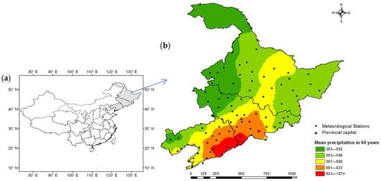
Figure 1.
(a) Location of the study area in China. (b) Location of Northeast China comprising 83 meteorological stations.
To ensure coherence of the precipitation records, meteorological stations with missing data < 5% were primarily selected. Monthly precipitation data for 1960–2019 from 83 weather stations were obtained from the National Climate Center of the China Meteorological Administration (available online on 1 September 2021: http://data.cma.cn/). Among the 83 stations, 30, 31, and 22 are in Heilongjiang Province, Jilin Province, and Liaoning Province, respectively. The data were available on a monthly and annual basis for all the selected meteorological stations without any data gaps. The boundary vector data and 83 meteorological station vector data of Northeast China were derived from the vectorized topographic map of 1:1,000,000 from the National Basic Geographic Data Center, which was corrected. Because each meteorological station exhibits different elevations and geographical positions, the time series rainfall data is very spatial. The meteorological records of the China Meteorological Administration were assessed to ensure consistency, continuity, and quality, taking into account the relocation of instrument locations and stations, where necessary, to mitigate the effects of vegetation and urbanization changes []. The specific locations of all 83 stations in the present study are shown in Figure 1.
2.2. Methodologies
2.2.1. Sen’s Slope Estimator Test
Sen’s slope estimator is a nonparametric linear slope estimator introduced by Theil (1950) and Sen (1968). This method has been extensively used in meteorological time series and is equally applicable for cases where data gaps exist. Therefore, it is widely used to predict the magnitude of temperature and precipitation trends; Sen’s slope estimator test was performed using Equation (1):
2.2.2. Mann–Kendall (MK) Rank Correlation Test
The MK rank correlation test is a nonparametric test widely used in trend analyses of time series. Mann first proposed this method and developed it with Kendall as a nonparametric test method. Since then, it has been used to perform trend change analyses of time series associated with precipitation and other factors. This test is neither disturbed by a small number of outliers nor does it require samples to follow a specific distribution. It is suitable for data with non-normal distributions, such as those used in hydrology and meteorology. Furthermore, it exhibits the advantages of simple calculations, a high degree of quantification, and a wide detection range. These tests comprise two series: a forward one, UF [], and backward series, UB. A typical confidence level of 95% is set to be the confidence line. The statistical series exhibits an increasing trend when UF > 0, and shows a decreasing trend when UF < 0. When UF exceeds the critical value, the changing direction of the original sequence becomes very significant. The range beyond the confidence line is identified as the time region where the mutation occurs. The intersection point of UF and UB, which is located between the confidence lines, represents the origin of the abrupt change. For time series , its UF sequential statistics was calculated as follows:
where ri is the ascending sequence number of time series X; E(sk) and Var(sk) are the mean and variance of Sk if UF > 0 or UF < 0, indicating an upward or downward trend of climate variables. The inverted time series XT = {xn, xn−1, …, x1} is recalculated to obtain the statistic UFkT and then the reverse statistic UB = −UFkT. This paper assumes that UFk and UBk all meet the standard normal distribution, and the significance of water taken at is 0.05. When the intersection of UF and UB exists in the interval [−1.96, 1.96], this point can be considered the mutation point of the time series. For the existing mutation points, the sliding t-test was further used to judge their significance.
2.2.3. MK Trend Model
The MK test (Mann, 1945; Kendall, 1975) is used to identify the trend of the given time series data. The primary purpose of the MK test is to statistically determine if there is a monotonic upward or downward trend associated with the variable of interest over time. The MK test was performed using Equation (5):
where xij and xj indicate the data values at times i and j, respectively, and n is the length of the data set. S is a normal distribution with a mean of 0. If the S value is positive, it means the variable consistently increases through time, whereas a negative S value indicates a decreasing trend. The variable S is approximately normally distributed when n ≥ 8. Consequently, the standard normal statistical variable, Z, can be expressed using Equation (7):
2.2.4. Inverse Distance Weighted (IDW) Approach
The IDW approach, also known as the inverse distance weighted method, is essentially a weighted moving average method [,]. It is a deterministic interpolation method in which the distance between the interpolation point and sample point is used as the weight parameter. The degree of drought and flood events during recent years was interpolated by implementing the IDW method using ArcGIS software (version 10). The IDW was calculated as follows:
where Q0 represents the estimated value of the point, Qi is the attribute value of the ith sample, i is the power of the distance, and Di is the distance. The surface to be interpolated should be the surface with local dependent variables, which influences each sampling point. The farther the distance, the weaker the influence and the smaller the weight.
2.2.5. SPI
The SPI uses the gamma probability distribution function to convert the long series of monthly precipitation data to a normal distribution, and then calculates the number of standard deviations from which the observed precipitation deviates from the long-term mean (Equation (10)):
where xij is the precipitation during the month i at station j, whereas
and σ represent the mean and standard deviation of the long-term precipitation record, respectively. This paper calculates the SPI value with the timescale of 1 month; SPI-1 is the SPI value with the monthly scale. Table 2 shows the textual classification of SPI values []. The SPI threshold range used to define the severity of the climatic anomaly is presented in Table 3 []. Furthermore, the occurrence times corresponding to different grades of the SPI are used to describe the spatial-temporal characteristics of climatic anomaly occurrences in the studied years.

Table 2.
Classification of SPI values.

Table 3.
Climatic anomaly classification based on SPI.
2.2.6. The Flow Chart for the Methodology
The extreme climate change in Northeast China from 1960 to 2019 was analyzed according to the following steps: (1) The precipitation data obtained from 83 stations were, firstly, arithmetically averaged for providing regional values. (2) The SPI was used to identify the occurrence, frequency, and intensity of drought and flood disasters, and drought and flood disasters were taken as the only objects of extreme climate research in this paper. (3) The Mann–Kendall rank correlation test, MK test, and Sen’s slope method were used to analyze the regional values and occurrence, and to detect abrupt changes and significant trends. (4) Based on the catastrophe results, the SPI was used to calculate the severity of the extreme climate. (5) The MK test method was used to analyze the trend of climate anomalies of each meteorological station. (6) The degree of climate anomalies in recent years was interpolated by the inverse distance weighted method using the ArcGIS software (version 10). The flow chart for the methodology is shown in Figure 2.
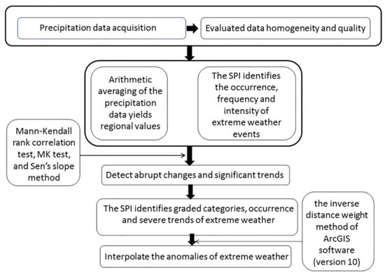
Figure 2.
The flow chart for the methodology of spatial and temporal analysis of extreme climate events over Northeast China.
3. Results
3.1. Temporal Trend Analysis of Regional Mean Precipitation and Frequency of Drought and Flood Events
The monthly and annual precipitation data in millimeters for all the 83 meteorological stations were calculated and analyzed to determine the precipitation variability in Northeast China. The time series of the regional average precipitation in Northeast China from 1960 to 2019 is shown in Figure 3a. The average annual precipitation in the study area is 606 mm, fluctuating between 474 mm to 767 mm in the time series. The MK test reveals that the average precipitation exhibits an insignificant increasing trend (Z = 0.01). Sen’s slope estimator test showed that the average precipitation increases annually by 0.019 mm. The occurrence times of climate anomalies in the time series are shown in Figure 3b. In this study, climate anomalies refer to meteorological drought and flood events. The average number of climate anomalies over the time series is 1.6 times per decade, with the minimum (0.86 times per decade) and maximum (2.55 times per decade) values being observed in 1996 and 2010, respectively. Using the MK test, an increasing trend of occurrence was detected at the 95% confidence level (Z = 2.3); meanwhile, Sen’s slope estimator test showed that the occurrence of climate anomalies increases slowly at a rate of 0.0058 times per decade.
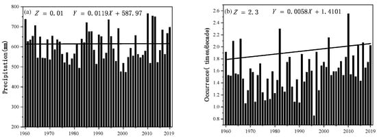
Figure 3.
Time series of regional mean precipitation and climate anomalies from 1960 to 2019. Solid lines represent Sen’s slope trends.
3.2. Results of Mann–Kendall Rank Correlation Test
Abrupt changes in climate anomalies were detected using the Mann–Kendall rank correlation test (Figure 4). According to the UF curve with 2001 as the node, climate anomalies in the study area showed a general trend of decline, rise, and then decline from 1960 to 2001; meanwhile, the variation trend was not significant. From 2001 to 2019, there was a significant upward trend, which significantly exceeded the critical line of 0.1 in the early 21st century. According to the MK rank correlation test, the UF and UB curves intersect. The intersection point is located between the critical line, and the time corresponding to the intersection point represents the actual beginning of the abrupt changes; thus, the time series mutation in this study began in 2006.
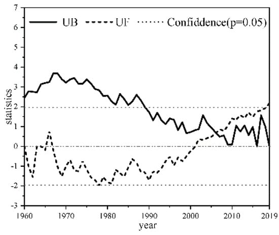
Figure 4.
Analysis of abrupt changes in climate anomalies using the MK rank correlation test from 1960 to 2019. As the UF curve achieves the confidence level (p = 0.05), the intersection points of UF and UB represent the starting point of the abrupt changes in the time series.
3.3. Temporal Characteristics of Climate Anomaly Category Frequency
The SPI was calculated from the historical precipitation record at a weather station in the study area. According to SPI classification, moderate, serious, and extreme climate anomalies during the two time series were averaged separately to investigate the intensity of annual climatic anomalies. The occurrences of different levels of climatic anomalies at meteorological stations for two decades are shown in Figure 5. From 2006 to 2019, the number of occurrences of all three types of abnormal climate events in the study area was more than that observed from 1960 to 2019. The results showed that the extreme climate anomalies in 2006–2019 (2.97 times per decade) were higher than those observed in 1960–2019 (2.33 times per decade). The number of moderate droughts and floods that occurred in 2006–2019 (5.30 times per decade) was much higher than that observed in 1960–2019 (4.34 times per decade). Similarly, the number of moderate climate anomalies in 2006–2019 (9.72 times per decade) was higher than that in 1960–2019 (9.29 times per decade). The results show that the two time series exhibit the most considerable differences in the occurrences of moderate climate anomalies, which almost equals one per decade.
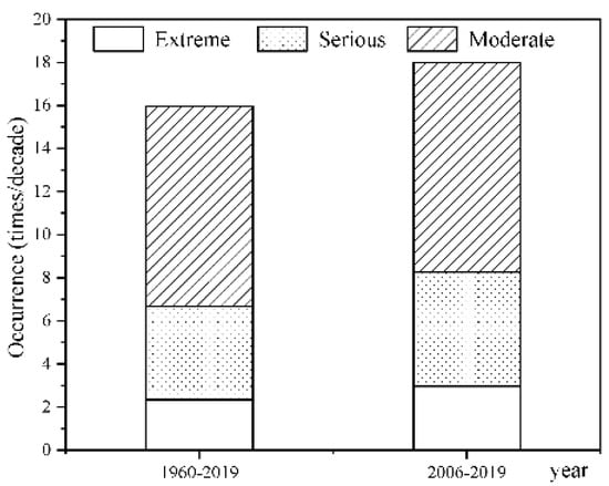
Figure 5.
Occurrence of moderate, serious, and extreme climate anomalies.
3.4. Spatial Distribution of Occurrence Frequency of Climate Anomalies
Figure 6 shows the spatial distribution associated with the frequency of climate anomalies, which was obtained using ArcGIS software. Based on the severity of climate anomalies and their abrupt changes, we analyzed the spatial characteristics associated with the frequency distribution of climate anomalies from 1960 to 2019 and 2006 to 2019. For the time series from 1960 to 2019, most geographical sites showed low frequencies (between 13.8 times per decade and 18.9 times per decade), with Xiongyue Station in Liaoning Province having the lowest frequency (13.8 times per decade) and Songjiang Station in Jilin Province having the highest frequency (18.9 times per decade). In the time series from 2006 to 2019, the occurrence frequency of droughts and floods varied between 11.43 and 22.86 times per decade; the highest frequency was observed in Suihua, Heilongjiang Province, and Luozihe Station, Jilin Province, whereas the lowest frequency was observed in Kuandian, Liaoning Province. By comparing the time series of 1960–2019 and 2006–2019, it can be concluded that the frequency of climate anomalies during 2006–2019 mainly ranged from 15 times per decade to 22.8 times per decade. From 2006 to 2019, the frequency of climate anomalies at 67 stations was more significant than that in 1960–2019. In other words, 80% of the study area experienced more frequent climate anomalies from 2006 to 2019 than from 1960 to 2019; the number of climate anomalies has increased in recent decades.
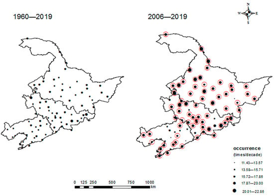
Figure 6.
Climate anomalies per decade during 1960–2019 and 2006–2019 over Northeast China. A red curve was placed around the exclamation marks for locations exhibiting a higher frequency of climate anomalies during 2006–2019 than during 1996–2019.
3.5. Z-Space Feature Mapping
Figure 7 shows the spatial distribution characteristics of the MK test results of 83 meteorological stations in the study area for the time series of 1960–2019. It reveals the trend of climate anomalies in the northeast over the past few decades. In the time series of 1960–2019, the stations with moderate climate anomalies followed the same spatial pattern as the stations with severe climate anomalies. It was found that 15 of the 83 stations showed significant climate anomalies from 1960 to 2019, 7 stations were at a 90% confidence level, and 8 stations were at a 95% confidence level. Moreover, the precipitation in Northeast China decreased from south to north and fluctuated less from east to west. The stations with moderate climate anomalies are concentrated in the region with less precipitation, whereas the stations with abundant precipitation exhibit no obvious change in the distribution direction. Based on precipitation data from 83 stations during the past 60 years (1960–2019), we calculated the SPI values of each station and interpolated the precipitation data and SPI values to identify the spatiotemporal variation characteristics of precipitation and extreme climate events in Northeast China. Therefore, the MK test was used to analyze the precipitation data trend of each station, Sen’s slope method was used to calculate the trend slope, the MK rank correlation test was used to determine the point at which abrupt changes in climate anomalies began, and the frequency of extreme climate events was interpolated into a graph. An increasing occurrence trend of precipitation was detected at the 95% confidence level (Z = 2.3). According to the timescale analysis, the abrupt changes started in 2006, and the temporal and spatial distribution of extreme climate events showed a significant upward trend in the time series from 2006–2019. The stations with extreme climate trends (trend of climatic anomaly with confidence level >90%) followed the same spatial pattern as those experiencing extreme climate events (more than 17.87 times/decade). The frequency of extreme climate and the affected area are on the rise, seriously threatening the economic security of Northeast China, as can be seen particularly in 2007, 2009, 2010, and 2019.
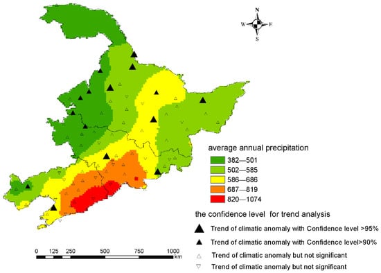
Figure 7.
Spatial distribution of extreme climate events according to the MK test in Northeast China from 1960 to 2019. The colors indicate average annual precipitation.
3.6. Mapping the Spatial Distribution of Different Climate Anomalies
Figure 8 shows the spatial extent of different climate anomalies from 2006 to 2019, with only two years (2015 and 2017) free of extreme climate disasters. Only serious and moderate climate anomalies occurred in a small study area in these two years. The study area suffered extreme climate anomalies on a small scale for the following years: 2006, 2008, 2011, 2012, 2013, 2014, 2016, and 2018. In addition, the study area affected by extreme climate anomalies (categories are extreme, severe, and moderate climate events) increased significantly in 2007, 2009, 2010, and 2019.
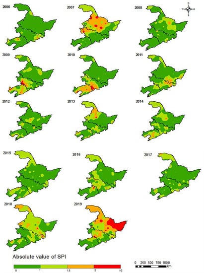
Figure 8.
Spatial distribution of SPI over the northeast during 2006–2019.
Moreover, due to serious and extreme droughts and floods in 2017 and 2019, Heilongjiang Province experienced the most large-scale climate anomalies, with more than 60 percent of the total area being affected. The area experiencing severe and extreme climate anomalies in 2019 was much larger than that in 2007. Similar to Heilongjiang, severe climate anomalies occurred on a significantly bigger scale in 2010 than in 2009 in the Liaoning Province.
4. Discussion
By analyzing the precipitation and its abrupt changes in the study area from 1960 to 2019, it can be concluded that precipitation exhibits an insignificant increasing trend (Figure 3a). Previous studies have also demonstrated that long-term precipitation in Northeast China showed no noticeable change in trends, but the fluctuations were substantial [,]. The annual fluctuation in precipitation had a volatile impact on agricultural production in Northeast China. The extreme shift from drought to flood conditions (and vice versa) was not conducive to increased crop production and income []. Tang identified that the number of heavy rain days in Northeast China decreased and that the annual precipitation intensity showed an insignificant increase [].
Previous studies mainly focused on drought or flood and simply analyzed the temporal and spatial characteristics of drought or flood. In addition, Northeast China is located in a climate-sensitive area and various weather anomalies occur frequently, but the probability of extreme drought or extreme flood has been relatively rare in history. It is not enough to use only one kind of climate disaster to represent the spatiotemporal characteristics of climate in Northeast China. This paper creatively regards drought and flood as a whole to analyze the impact of extreme climate on economic development in Northeast China. In this paper, to analyze the temporal variation characteristics of extreme climate events in Northeast China, the values of SPI-1 in the past 60 years were calculated by using meteorological data, and the change trends of extreme climate events over Northeast China in those 60 recent years were discussed using linear tendency estimation; the results are shown in Figure 3b. The frequency of extreme climate events shows apparent periodic oscillation. Similar to our study, a recent study showed that the interannual fluctuation of the extreme climate was greater than the linear trend []. Based on the MK test and Sen’s slope, the results of this study show that the frequency of drought and flood events exhibits a slowly increasing trend (Figure 3b). Based on precipitation data from 1960 to 2019, we inferred that the temperature in Northeast China fluctuated significantly during the study period. Previous research results have validated this prediction []. Wu et al. showed that significant increases in temperature and fluctuations in precipitation over the past few decades have led to a warming and drying trend in Northeast China [].
To assess the continuous and abrupt changes in extreme climate events in Northeast China on an annual scale, the MK mutation test was conducted to determine the frequency of extreme climate events in Northeast China (Figure 4). Results of the MK rank correlation test show that the frequency of extreme climate occurrence first decreased and then increased. Before 2001, the UF value exceeded 0 for only some of the years; it remained negative for most of the other years, indicating that the frequency of extreme climate events showed a downward trend. Since 2002, the UF value has remained positive, indicating that the frequency of extreme climate events showed an upward trend. The intersection of the UF and UB curves reveals that mutations in climate anomalies began in 2006; meanwhile, the UF curve exceeded the critical line in 2019, indicating a significant increasing trend.
To fully understand the evolution characteristics of moderate and above climate events in Northeast China in the past 60 years, the monthly SPI values of 83 stations in Northeast China in the past 60 years were calculated, and the frequency charts of extreme climate in different years were drawn. The occurrence frequency of climate anomalies corroborates the findings. In the time series from 2016 to 2019, the frequency of moderate, severe, and extreme drought and flood events increased; thus, the total number of climate anomalies also increased significantly (Figure 5). The spatial distribution map of drought and flood events shows that 80% of the three provinces in Northeast China suffered more frequent climate anomalies from 2006 to 2019 (Figure 6) than those observed from 1960 to 2019. The results of Li et al. showed that after the abrupt change of temperature in 1987, the fluctuation range of extreme climate increased significantly, and the events of severe drought and flood increased in the region []. According to Guo’s research, summer precipitation in Northeast China changed to a multidecadal stage in the early 21st century []. The interdecadal variation of precipitation in May in Northeast China in the early 21st century is mainly caused by the variation in the intensity of the Northeast Asia low-pressure system in May. In the early 21st century, the Northeast Asia low-pressure system has been more substantial than the climate state since it facilitates more precipitation in Northeast China. Meanwhile, the spatial and temporal distribution associated with the frequency of climate anomalies can be used to verify the abnormal climate fluctuation occurring from 2006 to 2019.
To analyze the spatial variation of extreme climate events in Northeast China, the annual SPI values in Northeast China were interpolated using the IDW method. The annual precipitation in the study area shows a decreasing trend from the southeast to the west. The occurrence of drought and flood events increased in the eastern Changbai Mountains, Liaodong Hills, and Heilongjiang region. Yang analyzed the spatial distribution of flood disasters in Northeast China and concluded that these disasters were more severe in the southeast region of Northeast China and the Heilongjiang region [,]. Moreover, Li analyzed the impact of rainstorms and flood disasters in Liaoning Province and established that flood disasters were more severe in areas with low mountains and hills in the north and northeast of Liaoning Province []. The spatial distribution of meteorological elements in Northeast China is not uniform, thereby complicating the drought and flood events. The sites with noticeable drought-flood trends had the same spatial pattern as those with high drought-flood frequencies during 1960–2019. The stations exhibiting significant climate anomaly trends were all located in areas with low precipitation. SPI interpolation results displayed the spatial extent of climate anomalies in the time series of 2006–2019 (Figure 8). The areas affected by severe and extreme climate anomalies were the largest in 2007, 2009, 2010, and 2019. Feng et al. demonstrated that the interannual variation of drought intensity in Northeast China was consistent with the interannual variation characteristics of drought events; that is, the influence range of the drought process was extensive [].
Northeast China, including Heilongjiang, Jilin, and Liaoning Provinces, is a vital commodity grain production base in China. Its grain output plays a critical role in maintaining China’s food security []. The most important crops in Northeast China are corn, rice, and soybeans, with nearly 25 million hectares (15.0 percent of China’s total agricultural area) being produced in 2018. Food production in Northeast China is an essential guarantee for the national food security strategy. In recent years, due to the impact of climate change and other factors, the risk of food production instability in Northeast China has increased; thus, actively responding to the effects of climate change on food production has become an essential requirement for stable food security [,].
The frequency and extent of climate anomalies have changed significantly in recent years. From 2006 to 2019, climate anomalies frequently occurred in Northeast China, with the affected areas increasing extensively. Apart from 2015 and 2017, the severity of climate anomalies was undeniable, especially in 2007, 2009, 2010, and 2019. Heilongjiang Province was affected the most by climate anomalies. Frequent extreme climate events are a great threat to the crop yield in Heilongjiang Province. According to China’s National Bureau of Statistics, the grain yield per unit area in Heilongjiang Province in 2007 was 3471.27 kg/ha (down by 4.9% than that in 2006). The yield of legume per unit area in 2007 was 1112.84 kg/ha (26.58% lower than that in 2006). The yield of maize per unit area in 2007 was 3921.01 kg/ha (14.57% lower than that in 2006). In 2009, the grain yield per unit area was 3,950.61 kg/ha (down by 2.04% than that in 2008), the legume yield was 1449.27 kg/ha (down by 3.8% than that in 2008), and the corn yield was 4,614.32 kg/ha (down by 7.27% than that in 2008). In 2010, the wheat yield per unit area was 3,303.41 kg/ha (16.76% less than that in 2009). For 2019, the yield per unit area of beans was 1803.5 kg/ha (0.54% lower than that in 2018) and the rice yield was 6986 kg/ha (1.59% lower than that in 2018). Therefore, extreme climate events tend to seriously affect crop output, thereby endangering food security and causing severe economic losses to farmers. Based on the historical evolution, trend analysis, and prediction results of extreme climate events, this study provides a theoretical basis for emergency control to alleviate the negative impacts of extreme weather on agricultural production and human life in Northeast China.
5. Conclusions
As a standard for quantizing the climatic anomaly degree, the drought index plays a vital role in monitoring and forecasting droughts as well as managing water resources [,]. This research creatively regarded drought and flood as a whole to analyze the impact of extreme climate on economic development in Northeast China; the variability of extreme climate events was assessed spatially and temporally using the SPI. The monthly and annual precipitation data of 83 meteorological stations in Northeast China were analyzed. The results show that: (1) The upward trend of occurrence was detected at the 95% confidence level (Z = 2.3) in the study area. (2) Abrupt changes in climate anomalies were determined to begin in 2006. Therefore, the temporal and spatial distribution of climate anomalies changed significantly in the time series from 2006–2019. (3) Stations with extreme climate trends (trend of climatic anomaly with confidence level >90%) followed the same spatial pattern as those with a high frequency of extreme climate disasters (more than 17.87 times/decade). (4) The severity and frequency of extreme climate have increasingly threatened Northeast China in the past decade. In particular, the Northeast Plain experienced the most severe and extreme climate events that seriously threatened the study area in 2007, 2009, 2010, and 2019. The spatial distribution of the SPI, which was determined by interpolating SPI values for each year from 2006 to 2019, also confirms this conclusion; the area and severity of disasters increased significantly in 2007 and 2019. In addition, decreased precipitation led to a more noticeable change trend of climate anomalies. However, because the SPI calculates droughts using only precipitation as the input, and temperature is another major factor affecting droughts, future global warming could increase the error in the calculation. In addition, the SPI has a good response to severe disasters but fails to reveal weak climate anomalies. This problem can be improved in the future.
Overall, these conclusions about extreme weather in Northeast China are beneficial for improving the monitoring and early warning of droughts and flood disasters, for achieving early detection and early prevention, and alleviating the adverse effects of extreme weather on agricultural production and people’s lives. Meanwhile, new crop varieties with resistance to climate anomalies should be cultivated as soon as possible to ensure food security in Northeast China and reduce economic losses caused by natural disasters.
Author Contributions
Conceptualization, X.Y. and Y.M.; methodology, X.Y.; software, Y.M.; validation, X.Y. and Y.M.; formal analysis, X.Y.; investigation, Y.M.; resources, X.Y.; data curation, Y.M.; writing—original draft preparation, Y.M.; writing—review and editing, X.Y.; visualization, X.Y.; supervision, X.Y.; project administration, X.Y.; funding acquisition, X.Y. All authors have read and agreed to the published version of the manuscript.
Funding
This work was supported by the Heilongjiang Postdoctoral Foundation (LBH-Z19068), 2017 Scientific Research Project of Harbin University of Commerce (Youth Project: 17XN041) and Philosophy and Social Science Research Planning Project of Heilongjiang Province (18GLH737).
Institutional Review Board Statement
Not applicable.
Informed Consent Statement
Not applicable.
Data Availability Statement
Not applicable.
Acknowledgments
We thanked Haifeng Zheng and Zhibin Ren, Northeast Institute of Geography and Agroecology, Chinese Academy of Sciences, for providing a review of earlier drafts of this manuscript and helping with English revisions, and all individuals who contributed to the successful accomplishment of this study.
Conflicts of Interest
The authors declare no conflict of interest.
References
- Cao, Y.; Lu, J.; Li, L. Analysis of multi-scale drought and flood characteristics in Liaoning Province based on SPEI. J. China Inst. Water Resour. Hydropower Res. 2021, 19, 210–220. [Google Scholar]
- Zhao, J.; Chen, L.; Zhang, D. Characteristics and Causes for the Climate Anomalies over China Summer 2021. Meteorol. Mon. 2022, 48, 107–121. [Google Scholar] [CrossRef]
- Yuan, X.; Zhang, J.; Teng, Z. Drought and Flood Evolution Law and Trend Prediction Analysis Based on SPI Index in Zuojiang River Basin. Water Power 2021, 48, 31–38. [Google Scholar] [CrossRef]
- Cao, Q.; Hao, Z.; Fu, X.; Hao, J.; Lu, C. Analysis of Spatial-Temporal Changes of Extreme Climatic Elements in China from 1960 to 2017. Yellow River 2020, 42, 11–17. [Google Scholar] [CrossRef]
- Li, Q.; Ma, Q. Extreme Precipitation Features ofArid Regions in Northwest of China. Sci. Geogr. Sin. 2014, 34, 1134–1138. [Google Scholar] [CrossRef]
- Zhang, Q.; Zhang, X.; Liu, Y. The Effects of Precipitation Concentration on Drought/Flood Events in Northeast China Based on CI and SPI. China Rural. Water Hydropower 2019, 11, 151–154. [Google Scholar] [CrossRef]
- Gu, X. Research on Evaluat ion T echnology of Abnormal Climate Effect on Agricultural Product ion. Meteorol. Mon. 2000, 26, 31–35. [Google Scholar] [CrossRef]
- Jiang, Y.; Liu, C.; Zheng, H.; Wu, L.X. Responses of river runoff to climate change based on nonlinear mixed regression model in Chaohe River Basin of Hebei Province, China. Chin. Geogr. Sci. 2010, 20, 152–158. [Google Scholar] [CrossRef][Green Version]
- Dawood, M.; Rahman, A.U.; Ullah, S.; Rahman, G.; Azam, K. Spatio-temporal analysis of temperature variability, trend, and magnitude in the Hindu Kush region using Monte Carlo and Sen’s slope approaches. Arab. J. Geosci. 2018, 11, 471. [Google Scholar] [CrossRef]
- Dutra, E.; Di Giuseppe, F.; Wetterhall, F.; Pappenberger, F. Seasonal forecasts of droughts in African basins using the Standardized Precipitation Index. Hydrol. Earth Syst. Sci. 2013, 17, 2359–2373. [Google Scholar] [CrossRef]
- Chen, X.; Wang, P. Climate changes over the Arctic land during 1979–2017. Resour. Sci. 2021, 43, 1260–1274. [Google Scholar] [CrossRef]
- Liu, l.; Ren, L.; Hong, Y.; Zhu, Y.; Yang, X. Sensitivity analysis of standardization procedures in drought indices to varied input data selections. J. Hydrol. 2016, 538, 817–830. [Google Scholar] [CrossRef]
- An, J.; Fu, B.; Li, W.; Peng, S.; Li, B. Future Prediction of Typical Extreme Climatic Indices and Population Exposure to High Temperature in East Asia. Acta Sci. Nat. Univ. Pekin. 2020, 56, 884–892. [Google Scholar] [CrossRef]
- Liang, F.; Liu, D.; Wang, W.; Zhang, F.; Yu, F. Temporal and spatial variability of summer extreme precipitation events in Northeast China during 1961–2013. Arid. Land Geogr. 2016, 39, 565–572. [Google Scholar] [CrossRef]
- Heim, R.R., Jr. A review of twentieth-century drought indices used in the United States. Bull. Am. Meteorol. Soc. 2002, 83, 1149–1165. [Google Scholar] [CrossRef]
- Zhang, X.; Zhang, Q.; Han, J. Spatial and temporal characteristics of drought in Northeast China at present and future climate change based on SPI. J. Meteorol. Sci. 2021, 41, 136–142. [Google Scholar] [CrossRef]
- Yuan, W.; Zhou, G. Theoratical Study and Research Prospect on Drought Indices. Adv. Earth Sci. 2004, 6, 982–991. [Google Scholar] [CrossRef]
- Wu, H.; Hayes, M.J.; Weiss, A.; Hu, Q. An evaluation of the Standardized Precipitation Index, the China-Z Index and the statistical Z-Score. Int. J. Climatol. 2001, 21, 745–758. [Google Scholar] [CrossRef]
- Ullah, I.; Yuanjie, Z.; Ali, S.; Rahman, G. Rainfall and drought variability in spatial and temporal context in Lop Nor region, South Xinjiang, China, during 1981–2018. Arab. J. Geosci. 2020, 13, 438. [Google Scholar] [CrossRef]
- Lloyd-Hughes, B.; Saunders, M.A. Seasonal prediction of European spring precipitation from El Niño-Southern Oscillation and Local sea-surface temperatures. Int. J. Climatol. 2002, 22, 1–14. [Google Scholar] [CrossRef]
- Manatsa, D.; Mukwada, G.; Siziba, E.; Chinyanganya, T. Analysis of multidimensional aspects of agricultural droughts in Zimbabwe using the Standardized Precipitation Index (SPI). Theor. Appl. Climatol. 2010, 102, 287–305. [Google Scholar] [CrossRef]
- Widhalm, M.; Wall, N.; Svoboda, M.; Hayes, M. The Lincoln Declaration on Drought Indices: Universal Meteorological Drought Index Recommended. Bull. Am. Meteorol. Soc. 2011, 92, 485–488. [Google Scholar] [CrossRef]
- Wu, H.; Svoboda, M.D.; Hayes, M.J.; Wilhite, D.A.; Wen, F. Appropriate of the standardized precipitation index in arid locations and dry seasons. Int. J. Climatol. 2007, 27, 65–79. [Google Scholar] [CrossRef]
- Yacoub, E.; Tayfur, G. Spatial and temporal of variation of meteorological drought and precipitation trend analysis over whole Mauritania. J. Afr. Earth Sci. 2020, 163, 103761. [Google Scholar] [CrossRef]
- Cheval, S.; Busuioc, A.; Dumitrescu, A.; Birsan, M.V. Spatiotemporal variability of meteorological drought in Romania using the standardized precipitation index (SPI). Clim. Res. 2014, 60, 235–248. [Google Scholar] [CrossRef]
- Wu, J.; Sheng, Z.; Du, J.; Zhang, Y.; Zhang, J. Spatiotemporal Change Patternes of Temperature and Precipitation in Northeast China from 1956 to 2017. Res. Soil Water Conserv. 2021, 28, 340–347. [Google Scholar] [CrossRef]
- Ma, J.; Xu, Y.; Pan, J. Drought tendency based on standardized precipitation index (SPI) and relative moisture index over Northeast China from May to September during 1961–2009. J. Meteorol. Environ. 2012, 28, 90–95. [Google Scholar] [CrossRef]
- Ye, L.; Zhou, J.; Zeng, X.; Zhang, H.; Lu, P.; Sun, X. Application of SPEI for the changes of drought in jialing river basin under climate change. Resour. Environ. Yangtze Basin 2015, 24, 943–948. [Google Scholar] [CrossRef]
- Dai, A. Increasing drought under global warming in observations and models. Nat. Clim. Chang. 2012, 3, 52–58. [Google Scholar] [CrossRef]
- Liang, F.; Liu, D.; Wang, W.; Zhang, F.; Wang, X. Temporal and Spatial Distributions of Drought in Northeast China in 1961-2014 Based on Standardized Precipitation on Evapotranspiration Index. J. Desert Res. 2017, 37, 148–157. [Google Scholar] [CrossRef]
- Lu, H.; Mo, X.; Meng, D.; Liu, S. Analyzing Spatiotemporal Patterns of Meteorological Drought and Its Responses to Climate Change Across Northeast China. Sci. Geogr. Sin. 2015, 35, 1051–1059. [Google Scholar] [CrossRef]
- LI, Y.; Li, Y. Advances in Adaptability of Meteorological Drought Indices in China. J. Arid. Meteorol. 2017, 35, 709–723. [Google Scholar] [CrossRef]
- Shen, Y.; Li, H.; Lei, Y. Research Review on Application of Drought Index. South North Water Transf. Water Sci. Technol. 2013, 11, 128–133. [Google Scholar] [CrossRef]
- Li, Q.; Dong, W.; Li, W.; Gao, X.; Jones, P.; Kennedy, J.; Parker, D. Assessment of the uncertainties in temperature change in China during the last century. Chin. Sci. Bull. 2010, 55, 1974–1982. [Google Scholar] [CrossRef]
- Li, L.; Zhu, X.; Sun, Z.; Zhang, J. Establishment and application of rainstorm flood disaster risk assessment model in Liaoning Province. J. Beijing Noraml Univ. (Nat. Sci.) 2015, 51, 49–56. [Google Scholar] [CrossRef]
- Sheng, W.; Xue, L.; Dai, K.; Xu, L. Inverse Distance Weighted Interpolation Algorithm Based on Image Edge Preserving. Sci. Technol. Eng. 2021, 21, 13793–13800. [Google Scholar]
- Zhao, Y.; Deng, Q. Impact of Inverse Distance Weighted Interpolation Parameters on Rill DEM Accuracy. J. China West Norm. Univ. (Nat. Sci.) 2022, 48, 1–11. [Google Scholar]
- Yu, X.; He, X.; Zheng, H.; Guo, R.; Ren, Z.; Zhang, D.; Lin, J. Spatial and temporal analysis of drought risk during the crop-growing season over northeast China. Nat. Hazards 2013, 71, 275–289. [Google Scholar] [CrossRef]
- Huang, S.; Huang, Q.; Wang, Y.; Chen, Y. Evolution of drought characteristics in the Weihe River Basin based on standardized precipitation index. J. Nat. Disasters 2015, 24, 15–22. [Google Scholar] [CrossRef]
- Han, D.; Yang, G.; Yan, D.; Fang, H. Spatial-temporal Feature Analysis of Drought and Flood in Northeast China in Recent 50 Years. Water Resour. Power 2014, 32, 5–8. [Google Scholar]
- Fan, Q.; Fang, J.; Li, X. Characteristics of dry-wet change in Northeast China during 1965–2015. Heilongjiang Meteorol. 2019, 36, 10–11+32. [Google Scholar] [CrossRef]
- Tang, B.; Yan, J.; Wang, L.; Liu, Y. Changes of precipitation events in Northeast China from 1960 to 2014. Resour. Sci. 2015, 37, 2514–2523. [Google Scholar]
- Gong, Q.; Wang, H.; Zhang, Y.; Wang, Y.; Cui, Y.; Zhou, X.; Zhang, H. Climate change and its impacts on extreme climate events in Liaoning Province of Northeast China. Chin. J. Ecol. 2013, 32, 1525–1531. [Google Scholar] [CrossRef]
- Cui, Y.; Xu, W.; Li, Q.; Zhao, C.; Zhou, X.; Ao, X.; Yu, J. Homogeneity Test and Correction of Monthly Temperature in Northeast China. Meteorol. Mon. 2019, 45, 240–250. [Google Scholar] [CrossRef]
- Li, B.; Zhou, X.; Zhao, Z.; Wang, J.; Wang, S.; Shang, K.; Li, P. Change Features of Different Types and Grades of Precipitation Event in Northeast China in Recent 50 years. Plateau Meteorol. 2013, 32, 1414–1424. [Google Scholar] [CrossRef]
- Guo, H.; Xiao, Z. Decadal variation of rainfall in May over Northeast China since the early 21st century and possible causes. Clim. Chang. Res. 2019, 15, 12–22. [Google Scholar] [CrossRef]
- Yang, Y.; Li, K.; Zhang, J.; Wei, S.; Liu, C.; Wang, C. Climatic Suitability Analysis of Millet Growing Season in Northern China Region in the Context of Climate Warming. Chin. J. Agrometeorol. 2022, 43, 215–228. [Google Scholar] [CrossRef]
- Yang, X.; Xu, Z.; Zuo, D.; Cai, S. Spatiotemporal evolution characteristics of drought-waterlogging in three provinces of Northeast China in past 55 years. J. Nat. Disasters 2016, 25, 9–19. [Google Scholar] [CrossRef]
- Feng, D.; Cheng, Z.; Wu, Q.; Zhu, J.; Qu, H.; Li, J. Meteorological drought characteristics in Northeast China from 1961 to 2014 based on the comprehensive monitoring index analysis. J. Arid. Land Resour. Environ. 2017, 31, 118–124. [Google Scholar] [CrossRef]
- Cui, N.; Yin, Q. Impacts of Climate Change on Grain Production in Northeast China and Countermeasures. J. Catastrophol. 2022, 37, 52–57. [Google Scholar] [CrossRef]
Publisher’s Note: MDPI stays neutral with regard to jurisdictional claims in published maps and institutional affiliations. |
© 2022 by the authors. Licensee MDPI, Basel, Switzerland. This article is an open access article distributed under the terms and conditions of the Creative Commons Attribution (CC BY) license (https://creativecommons.org/licenses/by/4.0/).