Article

Spatial and Temporal Characteristics of Extreme Dry and Wet Events in Xinjiang from 1960 to 2020 and the Analysis of Influencing Factors

Key Laboratory of Resource Environment and Sustainable Development of Oasis, College of Geography and Environmental Science, Northwest Normal University, Lanzhou 730070, China
*
Author to whom correspondence should be addressed.
Atmosphere 2022, 13(7), 1067; https://doi.org/10.3390/atmos13071067
Submission received: 10 June 2022 / Revised: 27 June 2022 / Accepted: 4 July 2022 / Published: 6 July 2022

Abstract

:
It is important to consider extreme climate events, reduce disaster losses, and formulate effective disaster prevention and mitigation countermeasures. Based on the daily data from 36 meteorological stations of Xinjiang from 1960 to 2020, in order to analyze the temporal–spatial variations and influencing factors of extreme dry and wet events in Xinjiang, a number of methods were used including climate trend, the Mann–Kendall test, the Fourier power spectrum, the contribution rate, partial least squares and cross-wavelet analysis. Results indicate that the annual average frequency of extreme dry/wet events has a decreasing/increasing trend, at the rate of 0.26 times/decade and 0.19 times/decade, respectively; the variation trend in extreme dry and wet events of four seasons are consistent with the annual counterpart, at the rate of −0.04 times/decade and 0.02 times/decade (spring), −0.08 times/decade and 0.05 times/decade (summer), −0.05 times/decade and 0.06 times/decade (autumn), and −0.1 times/decade and 0.08 times/decade (winter). Fe fluctuation is greatest in winter and the smallest in spring, so the transition to warm and wet is obvious in winter and spring drought is easy to occur; the variation extent of extreme dry and wet events in northern Xinjiang exceeds the counterpart in southern Xinjiang; 1986 and 1987 witnessed abrupt variation in extreme dry and wet events in Xinjiang, with indication of distinct periodic oscillations of 2.44, 2.94, and 5.69 years and 2.94 and 5.69 years, respectively; the extreme dry (wet) events are determined by meteorological factors, comprising precipitation, relative humidity and temperature, and the circulation factors constituted by Western Pacific Subtropical High-Intensity Area (East Asian Trough Intensity, Westerly Circulation and Western Pacific Subtropical High Area) and El Niño events.

1. Introduction

Statements of the IPCC AR6 report confirmed the undisputed impact of human activities on climate change [1] and a drastic increment, attributed to global warming, in the intensity, frequency, extent and hazards of high-temperature and extreme events [2,3]. The augmentation in global temperature generates a more active water circulation, an increase in rainfall and evaporation, and the herald of a high frequency of more severe extreme dry and wet events in some places [4], which has brought extensive damage to human life, property security, social and economic progress and an unexpected global crisis of food, water resources and energy security. Therefore, the research on extreme dry and wet events is now at the top of the academic agenda.
Drought monitoring indices consist of over 100 varieties, one of which selects a single meteorological element as the basis of determination, such as the percentage of precipitation anomaly (Pa) [5], the standardized precipitation index (SPI) [6], and the Z index [7], and the other is to use multiple meteorological elements for more rational determination, such as the standardized precipitation evapotranspiration index (SPEI) [8], the Palmer drought severity index (PDSI) [9], and the surface wetness index (SWI) [10]. Among them, the SPI index is a drought index applicable to multiple time scales, and the PDSI analyzes dry and wet conditions from the water balance perspective, which is a widely used index [11]. Based on the sensitivity of the PDSI to humidity and the characteristics of multiple time scales of the SPI, Vicente-Serrano proposed the SPEI, which is suitable for monitoring the effects of global warming on drought conditions. The above indices mostly focused on the study of drought conditions and have achieved fruitful results. However, there are a few studies that use the SPI and the PDSI to monitor extreme dry and wet events so far, and research based on the SPI index showed that the intensity of extreme dry and wet events increased significantly in Russia during the period 1995–2015, and the frequency of extreme wet events was higher than the frequency of extreme dry events [12]. Research based on the PDSI deemed that the total area of extreme dry zones has increased significantly since the 1970s [13], the total global land area of extreme dry and wet regions has increased from 20% to 38% [14], the total area of wet regions in the United States has increased from 12% to more than 24% since 1970, and the total area of dry regions has decreased by the same percentage since 1940 [15], and the frequency of extreme wet events in the Asian monsoon region has been increasing since the 19th century [16]. The surface wetness index not only reflects the hydrothermal balance of a region more objectively, but also has the advantages of a simple and convenient calculation process and less data requirement, which has become the most widely used drought index. In 1977, UNESCO used the surface wetness index as an indicator of the degree of wetness and dryness in the “Arid Zone Research” project [10], and it has been using this index in China for research on extreme dry and wet events since 2000. The results showed that the frequency of extreme wet events has generally decreased and the frequency of extreme dry events increased in the north of China [17], the Shiyang River basin [18], the Hexi area [19], Shihezi [20] and the Altay region [21], with all showing a decreasing/increasing trend in the frequency of extreme dry/wet events. The frequency of extreme dry events increased in the Yangtze River Delta [22] and Ningxia [23], and the frequency of extreme wet events decreased accordingly. It is clear that the variability in the above mentioned extreme dry and wet events is characterized by significant regional differences. In addition, extreme dry and wet events caused severe damage to plant ecosystems, resulting in a prominent decline in riparian community performance in Amsterdam [24], a global contraction in barley yields from 1964 to 2007, with average yield losses ranging from 3% to 11% [25], and an increase in larch mortality in Siberia [26].
Located in the northwest of China, accounting for 1/6 of China’s total land area, Xin-jiang is the undisputed Chinese province with the largest arable-land area and the largest cotton production base. Owing to its fragile ecological environment, Xinjiang supports 90% of its population with a cultivated area nearly 10% of its oasis, and so it is important to probe into the impact of extreme dry and wet events on the agroecology, life and property security in the research region. Therefore, the authors of this paper endeavor to resolve this scientific enigma with respect to the annual and seasonal variation pattern of extreme dry and wet events in Xinjiang, the transformative discrepancy between northern and southern Xinjiang, the extent of congruence with climate warming and the driving factors. Furthermore, grounded on the daily meteorological data collected from 36 meteorological stations in Xinjiang between 1960 and 2020, this paper analyzed the temporal–spatial variation and revealed the contributing factors of extreme dry and wet events in Xinjiang using various methodological approaches, in order to strengthen the capabilities of appropriate responses to risk for betterment of adaptation to climate change, adopt scientifically reasonable decisions for disaster prevention and mitigation, and advocate harmonious and coordinated human–nature relation development.

2. Materials and Methods

2.1. Study Area

Located in the northwest of China, deeply landlocked, characteristic of immense areas, the Xinjiang Uyghur Autonomous Region (73°29′54″–96°23′3″ E, 34°20′11″–49°10′55″ N) forms a distinctive landscape, namely two basins flanked by three mountains north to south (Figure 1), with a temperate continental arid climate typical of the average annual temperature between 4 and 13 °C, annual average precipitation less than 200 mm, scarce precipitation that is mostly distributed in summer, abundant sunshine and a temperature chasm. Many local inland rivers flow with heavy reliance on precipitation and glacial meltwater for replenishment, and among them is Tarim River, the first inland river in China. Local soil is categorized as gray-brown desert soil, gray-calcium soil, chestnut-calcium soil and black-calcium soil. Local vegetation is comprised of poplar, sorrel, salal, strange willow, hyacinth, bubble thorn, sand date, etc.

2.2. Data Resources and Methods

2.2.1. Data Resources

(1)
Meteorological data
In this paper, data from 14 national meteorological stations in northern Xinjiang and 22 counterparts in southern Xinjiang on diurnal mean temperature, maximum temperature, precipitation, relative humidity, wind speed and sunshine duration, from 1960 to 2020, are selected from the “China Meteorological Data Sharing Network” (http://cdc.cma.gov.cn/, accessed on 3 June 2021). The frequency of extreme dry and wet events at each station is determined by calculation of the surface wetness index.
(2)
Circulation Data
In this paper, the Area Index (WPSHAI) (X1), the Intensity Index (WPSHII) (X2) and the Northern Boundary Position Index (WPSHNBPI) (X3) of the Western Pacific Subtropical High (WPSH), the Area Index (NHPVAI) (X4) and the Intensity Index (NHPVII) (X5) of the Northern Hemisphere Polar Vortex (NHPV), the Tibetan Plateau Index (TPI) (X6), the Westerly Circulation Index (WCI) (X7), the Arctic Oscillation (AO) (X8), the North Atlantic Oscillation (NAO) (X9), the Pacific Decadal Oscillation (PDO) (X10) and the East Asian Trough Intensity Index (EATII) (X11) are handpicked from many circulation factors of the “National Climate Center Climate System Monitoring-Diagnosis-Prediction-Assessment Network” (http://cmdp.ncc-cma.net/cn/index.htm, accessed on 3 April 2021). Researchers obtained El Niño indices data from the website (https://www.psl.noaa.gov/enso/, accessed on 3 April 2021) for correlation analysis with extreme dry and wet events and explored the effects of atmospheric circulation.

2.2.2. Methods

(1)
Calculation of the surface wetness index and frequency of extreme dry and wet events
The surface wetness index is the underpinning of calculating the frequency of extreme dry and wet events and the way in which it is calculated as follows:
MI = P / ET O
MI is the surface wetness index; P is the daily precipitation in mm. ET O is the daily potential evapotranspiration in mm.
ET O = 0.048 R n G + γ 900 T + 273 u 2 e s e a + γ 1 + 0.34 u 2
Determination formula of extreme dry and wet events:
D W ij = W ij W i σ i
In the above equation, DWij denotes the standardized variable of the surface wetness index for month i in year j; Wij represents the surface wetness index for month i in year j; Wi signifies the multi-year average of the surface wetness index for month i; σi is the mean squared deviation of the surface wetness index for month i. The occurrence of an extreme dry event is defined as the standardized variable of the surface wetness index for that month ≤ −0.5; in contrast, if the index is ≥0.5, an extreme wetness event will occur [17].
(2)
The Mann–Kendall test
The Mann–Kendall test is applicable to all distributions; therefore, it is one of the most widely used mutation detection methods. It was used for mutation analysis of extreme dry and wet events in this paper, the intersection of the two curves of UF and UB is the mutation year, and the method is expanded upon in [27].
(3)
The Fourier power spectrum
In this paper, the utilization of the Fourier power spectrum is for the analysis of the frequency of extreme dry and wet events in Xinjiang between 1960 and 2020 to probe into its periodic variation pattern. Fourier transform takes a time-based pattern and measures every possible cycle; therefore, it is widely used and the method is expanded upon in [28].
(4)
Calculation of the contribution rate of meteorological factors
In this paper, the sensitivity analysis is carried out for transformation of the partial derivatives into dimensionless counterparts and exploration of the sensitivity coefficients of extreme dry and wet events to each meteorological factor and quantification of the contribution rate of different factors.
ET O = 0.048 R n G + γ 900 T + 273 u 2 e s e a + γ 1 + 0.34 u 2
S x = lim x / x 0 I a I a x x = I a x · x I a
  C vi = S vi · Rc vi
Cvi is the contribution rate of meteorological factor vi to extreme dry and wet events (%), Svi is the sensitivity coefficient of meteorological factor vi to extreme dry and wet events; Rcvi is the multi-year relative variation rate of meteorological factor vi, Trendvi is its multi-year linear tendency rate, and vi ¯ signifies its multi-year average value. The contribution of meteorological factors to the variation in the surface wetness index is calculated by Equation (5), and a positive value of Cvi indicates a positive contribution, namely, the value correlates with the contribution [28].
(5)
Partial least squares analysis
Traditional regression methods are prone to multi-collinearity, bringing about inaccurate results. By comparison, the partial least squares method leads to accurate results and equations, and the method is expanded upon in [29]. The standardized regression coefficients of the regression equation and the projected significant values of the variables are derived from the analysis results to show the extent to which the independent variable influences the dependent variable, and the regression coefficient correlates with the independent variable and the dependent variable. When the VIP value outstrips 0.8, it is generally considered to have a remarkable effect [30].
(6)
Cross-wavelet analysis
The advantage of cross-wavelet analysis is its analysis of the degree of interrelationship between two time series in addition to generation of the phase relationship between the two time series, conducive to the exploration of the correlation between extreme dry and wet events and El Niño events in Xinjiang in a precise and distinct way by the following methods.
For two energy finite signals, x(t) and y(t), the cross-wavelet transformation is:
C x , y a , b = W x a , b W y × a , b
where C x , y a , b are the cross-wavelet transformation coefficients, which represent the magnitude of the correlation between two signals—a larger value indicates closer correlation [31,32].

3. Results

3.1. Temporal Variation Characteristics of Extreme Dry and Wet Events in Xinjiang

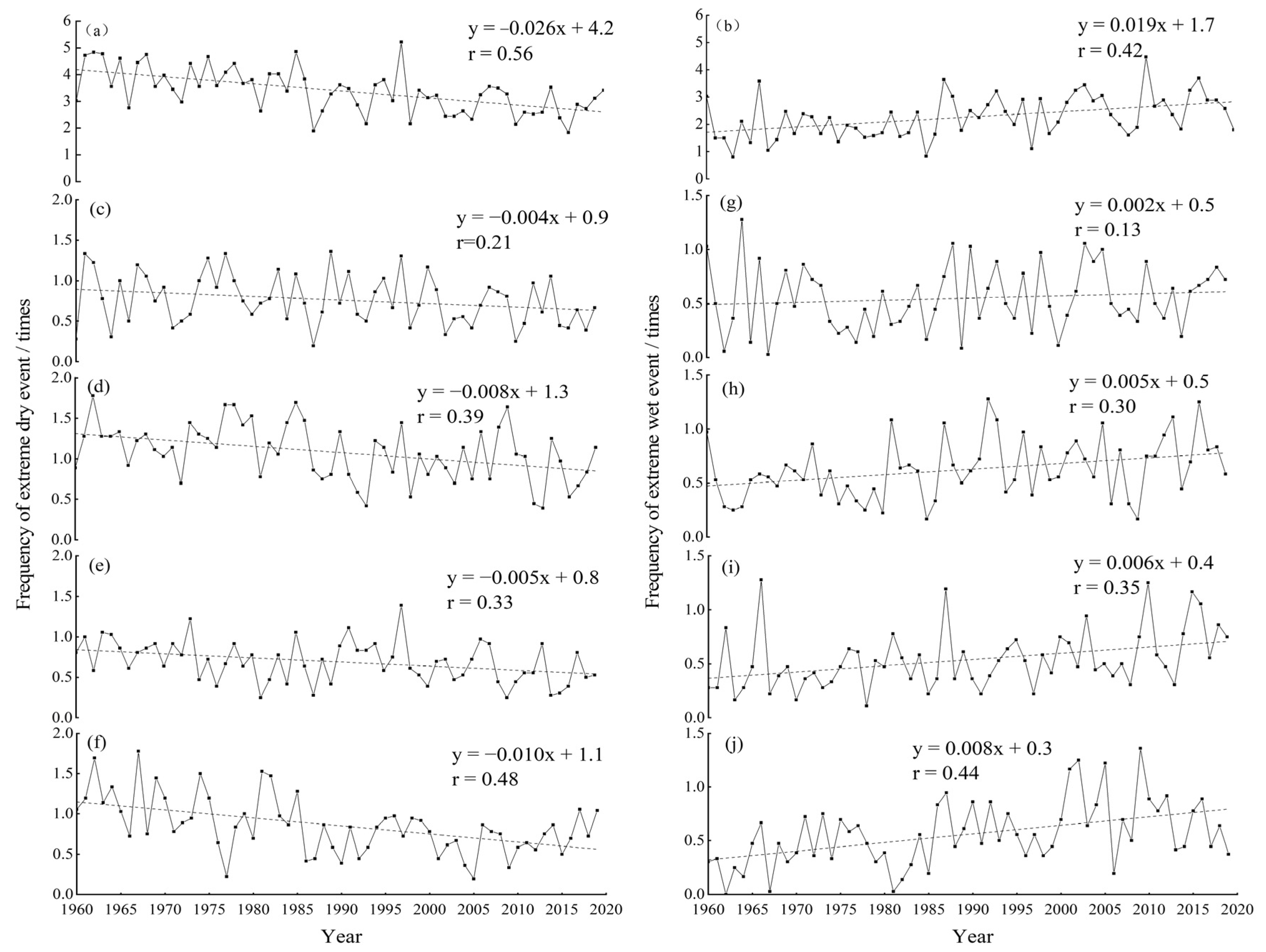
The interannual variation trend in the frequency of extreme dry and wet events in Xinjiang is calculated using the surface wetness index and its standardization is grounded in the meteorological data from 36 stations in the study area (Figure 2a,b). Figure 2a shows that the overall frequency of extreme dry and wet events in Xinjiang has fluctuated over the previous 61 years. Furthermore, the frequency of extreme dry events has represented a downward trend in fluctuation, with a downward trajectory of 0.26 times/decade and increased volatility during the 1980s and 1990s—the multi-year average of the frequency is 3.39 times, with a frequency of 32 respective years above the average in comparison to that of 29 respective years below the average. The maximum value of the frequency was 5.22 times, peaking in 1997, and the minimum value was 1.83 times, reaching a nadir in 2016; the frequency of 14 years is more than 4 times, which was extreme from the 1960sto the 1980s, indicative of the highest frequency of extreme dry events within the time span. The frequency of extreme wet events is on the rise and in fluctuation (Figure 2b), and the rate of increase is 0.19 times/decade. The multi-year average of frequency is 2.27 times, with a frequency of 30 respective years above the average and the counterpart of 31 respective years below the average. The value peaked in 2010, by 4.47 times, and the value reached rock bottom in 1963, by 0.8 times only. The frequency increased by 4 times in one year, and the frequency of extreme wet events overtook the average since the 1980s. In conclusion, the increasing rate of extreme wet events is less than the decreasing rate of extreme dry events, indicative of the wetness tendency in Xinjiang since 1980, consistent with the conclusion that the climate of northwestern China is transforming into a warm and wet climate [33] and the increase in wetness in Xinjiang [34]. In addition to this, two anomalously high values of extreme dry and wet event frequencies, respectively, corresponded to years in addition to 1997, an El Niño year, and 2010, a La Niña year, transferred from El Niño, indicative of the response of the northwestern region to El Niño events [35].
From the perspective of seasonal changes (Figure 2c–j), in the previous 61 years, the annual average frequency of extreme drought events in all four seasons in Xinjiang showed a decreasing trend (Figure 2c–f), particularly, the fastest decreasing rate in winter, for 0.1 times/decade, with an annual average frequency of 0.85 times, with the maximum value in 1967, with a frequency of 1.78 times, and the minimum value in 1977, with a frequency of 0.22 times; the winter is followed by summer showing a decreasing tendency, with a decreasing rate of 0.08 times/decade, an annual average frequency of 1.08 times, a maximum value in 1962, with a frequency of 1.78 times, and a minimum value of 1993, with a frequency of 0.42 times. The rate of decline in autumn is 0.05 times/decade, with an annual average frequency of 0.69 times, and a maximum value reaching 1.39 times in 1997, and a minimum value of 0.25 times in 1981 and 2009; spring shows the slowest decline, 0.04 times/decade, with an annual average frequency of 0.76 times, a maximum value in 1989, with a frequency of 1.36 times, and a minimum value of 0.19 times in 1987.
In all four seasons, the frequency of extreme wet events is on the rise (Figure 2g–j), particularly in the winter, rising at the fastest rate of 0.08 times/decade, with an annual average frequency of 0.56 times, a maximum value in 2009, with a frequency of 1.36 times, and a minimum value in 1962, with a frequency of 0 times; followed by autumn, increasing at a rate of 0.06 times/decade, with an annual average frequency of 0.54 times, a maximum value in 1966, with a frequency of 1.28 times, and a minimum value in 1978, with a frequency of 0.11 times; the frequency of extreme wet events in summer increased to rate of 0.05 times/10a, with an annual average frequency of 0.63 times, a maximum value of 1963, with a frequency of 0.25 times, and a minimum value in 1985 and 2009, with a frequency of 0.17 times; the frequency of extreme wet events in spring increases at the slowest rate, 0.02 times/decade, with an annual average frequency of 0.55 times, a maximum value in 1964, with a frequency of 1.28 times, and a minimum value in 1967, with a frequency of 0.028 times.
In summary, the declining trajectory of extreme dry events in Xinjiang is significantly faster than the rate of increase in extreme wet events; and the rate of decline/increase in extreme dry/wet events reaches a peak in winter and then decreases to rock bottom in spring, indicative of the most noteworthy warm and wet transformation in winter in the research area, consistent with the findings that extreme dry/wet events in the Altai region are decreasing/increasing in winter [21], the phenomenon of spring drought still exists and the conclusion that extreme dry and wet events undergo consistent variation in Xinjiang, both annually and seasonally [36].
Further analysis reveals the trend in the frequency of extreme dry and wet events in northern and southern Xinjiang (Figure 3), showing that in the previous 61 years, there was a declining rate of extreme dry events in northern Xinjiang at 0.39 times/decade, with an annual average frequency of 4.36 times, a maximum value in 1997, with a frequency of 7.21 times, and a minimum value in 2016, with a frequency of 1.5 times. Further, the declining rate of extreme dry events in southern Xinjiang is 0.19 times/decade, with an annual average frequency of 2.78 times, a maximum value in 1986, with a frequency of 3.68 times, and a minimum value in 2005, with a frequency of 1.5 times. The rising rate of extreme wet events in northern Xinjiang is 0.25 times/decade, with an annual average frequency of 2.72 times, a maximum value in 2016, with a frequency of 5.64 times, and a minimum value in 1963 and 1967, with a frequency of 0.71 times. The mounting rate in southern Xinjiang is 0.15 times/decade, with an annual average frequency of 1.99 times, a maximum value of 4 times in 2010, and a minimum value of 2.95 times in 1987.
This shows that the variation pattern of extreme dry and wet events in northern and southern Xinjiang is consistent its the counterpart in Xinjiang, but the magnitude of variation in extreme dry and wet events in northern Xinjiang is greater, indicative of the north of Xinjiang being more significantly wetter and more sensitive in response to climate change.

3.2. Spatial Distribution Characteristics of Extreme Dry and Wet Events in Xinjiang

In this paper, the frequency of extreme dry and wet events at each site is used as a parameter, and the spatial distributions of extreme wet and dry events in Xinjiang are derived separately (Figure 4). As shown in Figure 4, spatial differences between extreme dry and wet events in Xinjiang are conspicuous and more significant in southern Xinjiang. The sites of maximum and minimum frequencies of extreme dry events in northern Xinjiang are Wucha and Naomao lake in southern Xinjiang, with frequencies of 5.09 times/a and 0.59 times/a, respectively. The sites of maximum and minimum frequencies of extreme wet events in southern Xinjiang are Balikun and Naomao lake, with frequencies of 3.11 times/a and 1.31 times/a, respectively. Comparing northern and southern Xinjiang, the frequency of extreme dry and wet events in the north outstrips that in the south, and the frequency of extreme dry events overtakes the frequency of wet events in the north, indicative of northern Xinjiang on the whole being more sensitive to climate change.

3.3. Mutation and Periodic Oscillation

The research on mutation and periodic oscillation helps us to better analyze the regularity of extreme dry and wet events.

3.3.1. Mutation

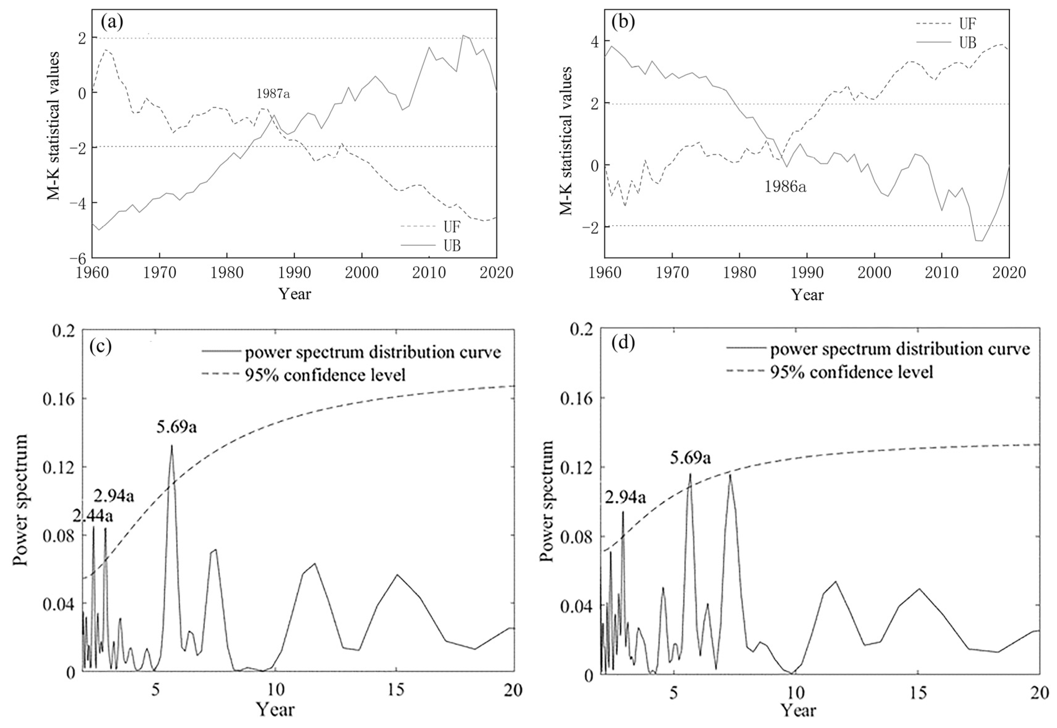
The UF and UB curves of extreme dry/wet events intersected in 1987/1986 (Figure 5a,b), with a significance of 0.05, indicative of the mutation of extreme dry events in 1987, an abrupt decrease after 1987, and the abrupt change in extreme wet events in 1986 and, unexpectedly, the declining trajectory turning in reverse. In the years following 1986, an abrupt change in extreme dry events in Shihezi occurred [20], conforming to the time span of climate transition in the northwest of China since 1987 [33].

3.3.2. Periodic Oscillation

In the previous 61 years in Xinjiang, there were short periodic oscillations of 2.44a, 2.94a and 5.69a for extreme dry events (Figure 5c), with extreme wet events of short periodic oscillations of 2.94a and 5.69 a (Figure 5d), both surpassing the 95% confidence level. Periodic oscillations in extreme dry and wet events have the same pattern, as extreme wet events decrease in years in which there are more extreme dry events [17]. The co-existence of short periodic oscillations of 2~3a and 5.69a for extreme dry and wet events conforms to the atmospheric circulation periodic oscillation of 2–4a and the El Niño periodic oscillation of 2–7a, respectively, reflective of the occurrence of extreme dry and wet events in a close relationship with atmospheric circulation activities and El Niño events.

4. Analysis of Influence Factors

Relative to the global scale, regional climate variation is influenced by more factors and the attribution is extremely complicated [37]. In this paper, researchers analyzed the causes of extreme dry and wet events from the perspectives of meteorological factors and circulation factors, and explored the extent to which regional extreme dry and wet events respond to global climate change.

4.1. Meteorological Factors

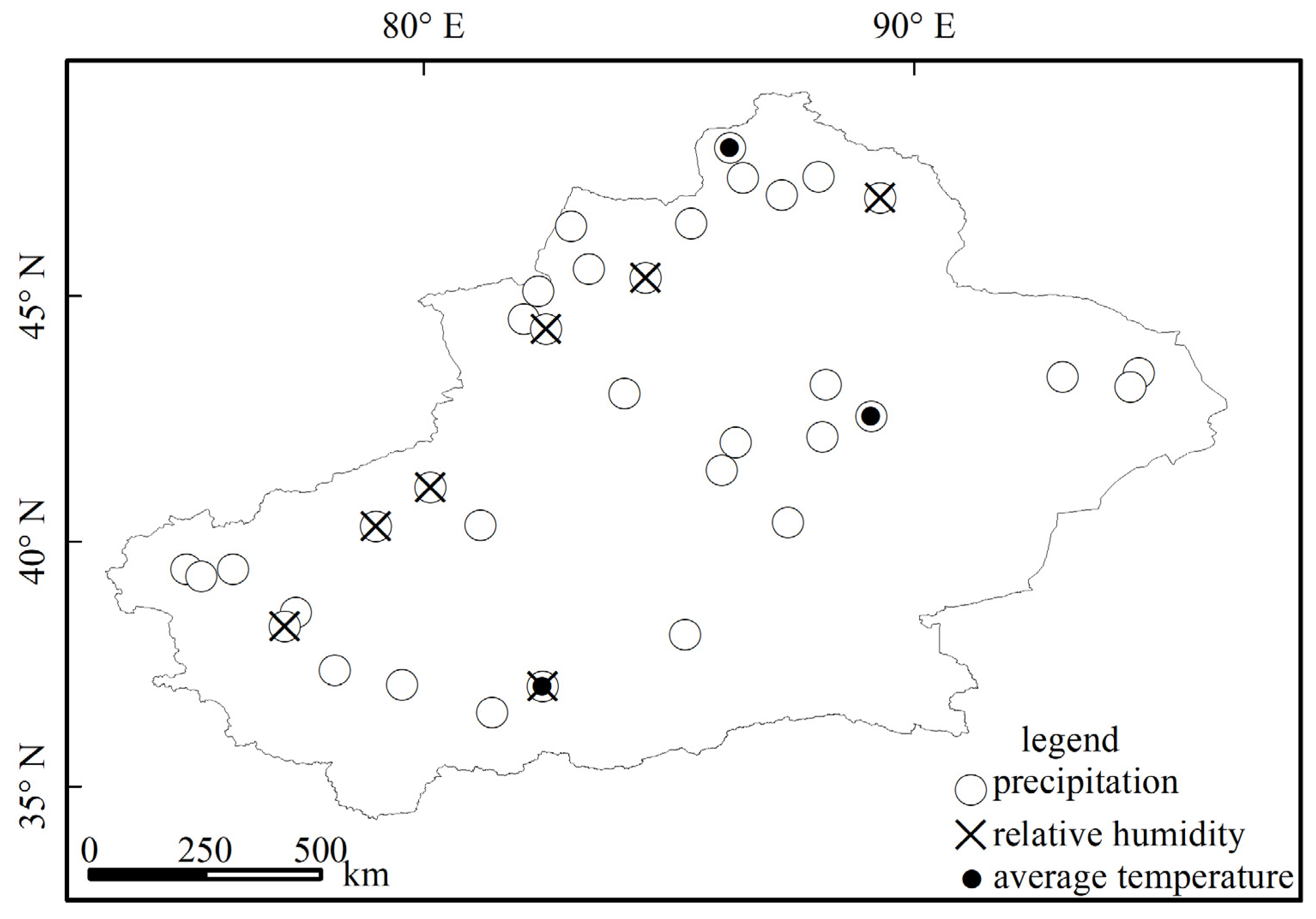
Since the occurrence of extreme dry and wet events is mainly determined by the surface wetness index, which is mainly grounded in precipitation and potential evaporation, six key meteorological factors that impact precipitation and potential evaporation—mean temperature, maximum temperature, wind speed, sunshine duration, relative humidity and precipitation—are handpicked and used for sensitivity analysis in order to obtain the contribution rate of each meteorological factor to the surface wetness index (Figure 6) for the determination of the extent to which each meteorological factor influences extreme dry and wet events.
Deduced from Figure 6, the spatial differences in the influence of meteorological factors on extreme dry and wet events are prominent, with only three site factors with absolute values of the contribution rate exceeding 15% among six factors, three factors consisting of average precipitation, relative humidity and average temperature, and with the corresponding number of sites being 35, 7 and 3, accounting for 97.2%, 19.4% and 8.2% of the total number of sites in the same order. These three factors are the main factors that influence the extreme dry and wet events in Xinjiang, with precipitation as the main factors, which is consistent with the above conclusion of the transition to warm and humid in northwestern China [33].

4.2. Circulation Factors

4.2.1. Relationship between Extreme Dry and Wet Events and the Atmospheric Circulation Index

Since the strength of the WPSH has a great influence on summer monsoon in China, the shift in area and intensity is closely related to extreme weather events in the northwest of China [38,39], and causes many abnormal precipitation events in Xinjiang [40]; the NHPV is a sweeping cyclonic circulation system, which has a certain interdecadal time scale influence on climate anomalies in China [41], and its interaction with the South Asian monsoon region and subtropical high pressure has an impact on the climate in northern China [42]. The Tibetan Plateau is the highest plateau in the world, hence it is the plateau to which climate change in the northwestern arid zone of China is attributed [43], and its dynamical, thermal, and obstructive effects on the Westerly Circulation undermine the dry and wet characteristics of the northwest of China [44]. The Westerly Circulation interaction with the South Asian monsoon region affects the water vapor transport process in the northwest of China [45], generating distinct characteristics of precipitation in northwestern China with the strength of the Westerly Circulation. The AO has an important influence on extreme temperature changes in China [46], the NAO can cause unusual easterly winds [47], and the dryness and humidity in north China and northwest China are closely related to the PDO [48]. Meanwhile, the strength of EAT also affects water vapor transport in China [49]. The occurrence of El Niño causes global climate anomalies and is one of the major causes of droughts and floods in China [50].
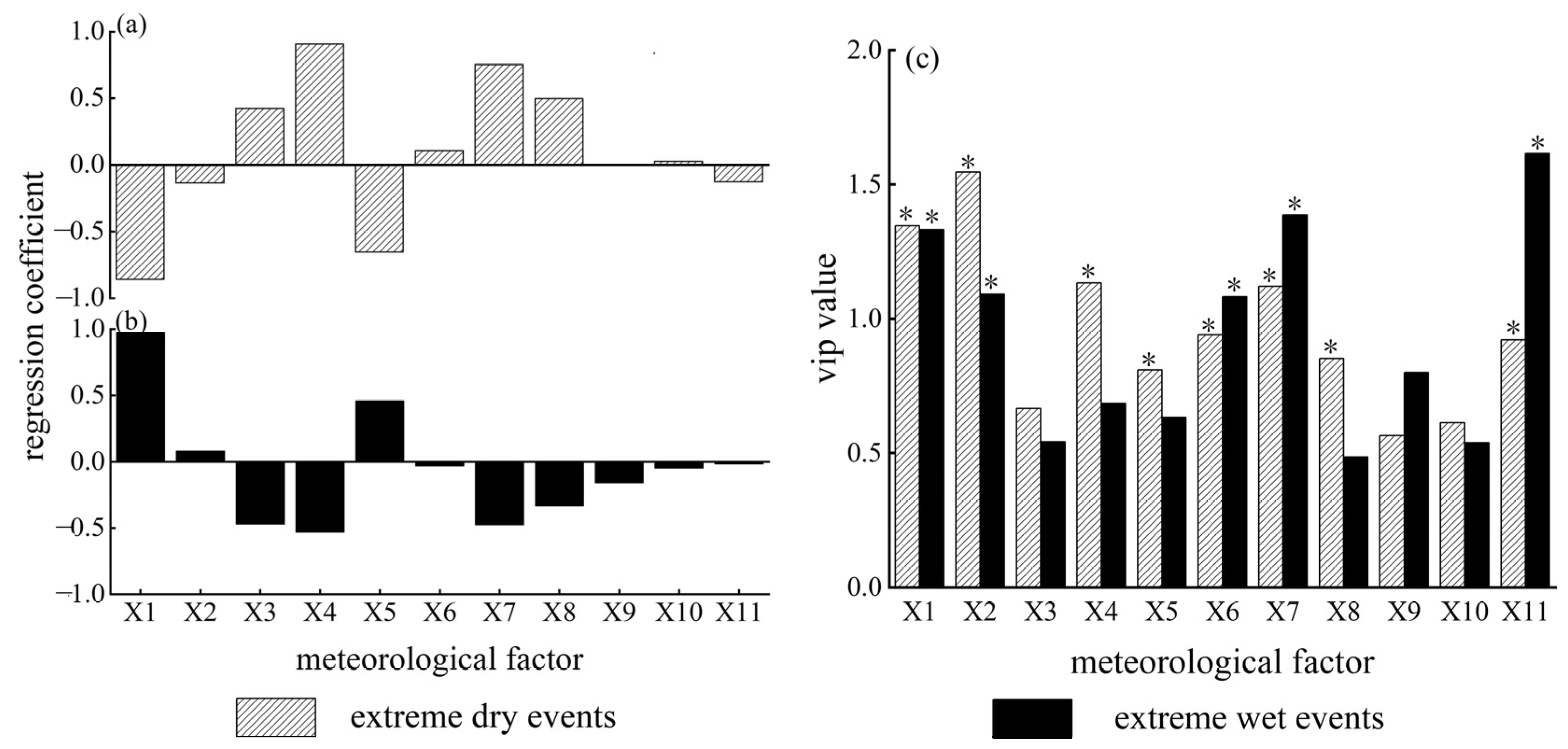
Consequently, this paper applies partial least squares to derive the extent to which each circulation factor influences the frequency of extreme dry and wet events in Xinjiang (Figure 7). Deduced from Figure 7, the frequency of extreme dry events in Xinjiang positively correlates with the WPSHNBPI, the NHPVAI, the TPI, the WCI, the AO and the PDO. Moreover, the frequency of extreme dry events in Xinjiang negatively correlates with the WPSHAI, the WPSHII, the NHPVII, the NAO and the EATII (Figure 7a). The WPSHII and the WPSHAI have the highest VIP values of 1.55 and 1.35 (Figure 7c), respectively, indicating that they are the main factors affecting extreme dry events; the frequency of extreme wet events positively correlates with the WPSHAI, the WPSHII and the NHPVII; furthermore, the frequency of extreme wet events negatively correlates with the WPSHNBPI, the NHPVAI, the TPI, the WCI, the AO, the NAO, the PDO and the EATII (Figure 7b). The EATII, the WCI and the WPSHAI have the highest VIP values of 1.63, 1.39 and 1.33 (Figure 7c), respectively, indicating that they are the main factors affecting extreme wet events.

4.2.2. Relationship between Extreme Dry and Wet Events and El Niño Events

Utilizing cross-wavelet analysis revealed the relationship between El Niño events and the frequency of extreme dry and wet events. Deduced from Figure 8 (left), the previous 61 years witnessed 3 resonance cycles of El Niño events and the frequency of extreme dry events in Xinjiang; concretely speaking, the cycles are comprised of a 2–3a anti-phase resonance cycle from 1967 to 1973, a 2–6a main resonance cycle from 1984 to1998 and a 1–3a positive phase resonance cycle from 1995 to 2000. There are six resonance cycles of El Niño events and the frequency of extreme wet events in Xinjiang (Figure 8 right). The main resonance cycle lies in 2–6a (1984–1993), with an oscillation energy spectrum value of approximately 3. Indicative of the correlation of extreme dry and wet events with El Niño events within the time span, extreme dry and wet events are influenced by atmospheric circulation and El Niño.

5. Discussion

Grounded on meteorological data collected from 36 meteorological stations in Xinjiang, this paper calculated the surface wetness index for each station and analyzed the variation in the frequency of and contributors to extreme dry and wet events in Xinjiang between 1961 and 2020. Scientific enquiries of the responsiveness of the research area to global climate change are important for provision of scientifically reasonable climate change measures, particularly preventive and mitigatory solutions, guarantee of food and ecological security. This research unearthed that the frequency of extreme dry/wet events in Xinjiang demonstrates a decreasing/increasing tendency, regardless of months, seasons or localities of Xinjiang, which is congruent with the majority of available studies as well as with the postulation that the climate in the northwest of China is undergoing a transition from warm and dry to warm and wet [33]. Studies in Northern China [17], the Altay region [21], Shihezi [18] and the Tianshan mountains [51] show that the frequency of extreme dry events has decreased, while the frequency of extreme wet events has gradually increased. The variation rate of extreme dry and wet events obtained in this research is inconsistent with that in Shihezi (−0.45 times/10a and 0.39 times/10a) and the Tianshan Mountains (−0.4 times/10a and 0.37 times/10a), indicating that there are differences within Xinjiang, which may be caused by different termination years of the study data. Nevertheless, internal characteristics consist of the lowest velocity of decreasing and increasing tendency towards the frequency of extreme dry and wet events in spring, indicating a significant dry phenomenon in spring, which is unfavorable to crop growth, and the regional difference in a higher frequency in northern Xinjiang and prominent spatial disparity in southern Xinjiang. In addition, research in the Altay region showed that extreme wet events occurred frequently in the 1990s [21], which was different from the conclusion in this paper that extreme wet events occurred frequently in Xinjiang in the 1980s. This shows that Xinjiang is more sensitive to climate change on the whole. In addition, research on the factors contributing to extreme wet and dry events is relatively scarce, with only a few studies focusing on temperature, precipitation, El Niño events [52], plateau monsoon [53], and Pacific Chronological Seasonal Oscillation [54]. However, this paper used the contribution rate to derive the major contributors of meteorological elements, and used partial least squares to reveal the influence of the WPSHAI, the WPSHII, the WPSHNBPI, the NHPVAI, the NHPVII, the TPI, the WCI, the AO, the NAO, the PDO and the EATII in a comprehensive manner. Unfortunately, the re-search area is located in the northwest of China, where sparse meteorological stations and a short span of a mere 61 years of recorded data are available, which increases the difficulty of pinpointing variation patterns of extreme dry and wet events in Xinjiang.

6. Conclusions

Firstly, the previous 61 years witnessed a decreasing/increasing trend in the frequency of extreme dry/wet events in Xinjiang annually, seasonally and in both northern and southern Xinjiang. Furthermore, the rate of decline in extreme drought events (−0.26 times/decade) outstrips the rate of increase in extreme wet events (0.19 times/decade). Moreover, the rates of decrease/increase in extreme dry/wet events in Xinjiang reach the apex in winter (−0.1 times/decade and 0.08 times/decade) and plummet to rock bottom in spring (−0.04 times/decade and 0.02 times/decade), with summer (−0.08 times/decade and 0.05 times/decade) and autumn (−0.05 times/decade and 0.06 times/decade) in the middle, indicating that the research area is undergoing the transition from dry to wet in winter, and drought still subsists in spring.
Secondly, spatial differences between extreme dry and wet events in Xinjiang are prominent, particularly in southern Xinjiang, the location of all the stations with the maximum and minimum frequencies of extreme dry and wet events. However, the average frequency of extreme dry and wet events is higher in northern Xinjiang.
Thirdly, extreme dry and wet events in Xinjiang vary abruptly in 1987 and 1986, which is fundamentally accordant with the postulation that climate in northwestern China has been transformed since 1987, with relatively consistent periodic oscillations of extreme dry and wet events being 2.44, 2.94, and 5.69 years and 2.94 and 5.69 years, respectively.
Last but not least, the analysis of meteorological factors shows that precipitation predominantly contributed to the surface wetness index, followed by the relative humidity and temperature. The WPSHII, the WPSHAI (the EATII, the WCI and the WPSHAI) are the main factors influencing extreme dry (wet) events in Xinjiang. In addition, extreme dry and wet events are correlated with El Niño events for years, which is congruent with the conclusions of the cycle analysis in this paper.

Author Contributions

Conceptualization and methodology, M.G. and X.Q.; software, M.G., M.W. and X.W.; formal analysis, M.G.; investigation, M.G. and M.W.; resources, X.Q.; data curation, X.W. and M.W.; writing—original draft preparation, M.G.; writing—review and editing, P.L.; visualization, M.W.; supervision, P.L.; project administration, P.L.; funding acquisition, P.L. All authors have read and agreed to the published version of the manuscript.

Funding

This research was funded by the National Natural Science Foundation of China, grant number 41561080.

Institutional Review Board Statement

Not applicable.

Informed Consent Statement

Not applicable.

Data Availability Statement

Meteorological data covering the analysis period were obtained from https://data.cma.cn (accessed on 3 June 2021), circulation data were obtained from http://cmdp.ncc-cma.net/cn/index.htm (accessed on 3 April 2021), and El Niño indices date were obtained from https://www.psl.noaa.gov/enso/ (accessed on 3 April 2021).

Acknowledgments

Thanks to Lu Liu for her methodological teaching and writing help during the research process. Thanks to Binyue Liang for her support.

Conflicts of Interest

The authors declare no conflict of interest.

References

  1. IPCC. Climate Change 2021: The Physical Science Basis. In Contribution of Working Group I to the Sixth Assessment Report of the Intergovernmental Panel on Climate Change; Masson-Delmotte, V., Zhai, P., Pirani, A., Connors, S.L., Péan, C., Berger, S., Caud, N., Chen, Y., Goldfarb, L., Gomis, M.I., et al., Eds.; Cambridge University Press: Cambridge, UK, 2021. [Google Scholar] [CrossRef]
  2. Wang, Y.; Zhang, X.M.; Zhou, N.F.; Hu, Z.G.; Li, G.Y.; Lv, Y.; Wang, Y. Evolution characteristics of global meteorological and hydrological disasters from 1990 to 2019. J. Atmos. Sci. 2021, 44, 496–506. (In Chinese) [Google Scholar] [CrossRef]
  3. Yao, Y.; Wang, C. Variations in Summer Marine Heatwaves in the South China Sea. J. Geophys. Res. Ocean. 2021, 126, e2021JC017792. [Google Scholar] [CrossRef]
  4. IPCC. Climate Change 1995: The science of climate change. In Contribution of Working Group I to the Second Assessment Report of the Intergovernmental Panel on Climate Change; Houghton, J.T., Meira Filho, L.G., Callander, B.A., Harris, N., Kattenberg, A., Maskell, K., Eds.; Cambridge University Press: Cambridge, UK, 1996. [Google Scholar]
  5. Mishra, A.K.; Desai, V.R. Drought forecasting using stochastic models. Stoch. Environ. Res. Risk Assess. 2005, 19, 326–339. [Google Scholar] [CrossRef]
  6. Mckee, T.B.; Doesken, N.J.; Kleist, J. The Relationship of Drought Frequency and Duration to Time Scales. In Proceedings of the 8th Conference on Applied Climatology, Anaheim, CA, USA, 17–22 January 1993; Volume 17, pp. 179–183. [Google Scholar]
  7. Karl, T.R. Some spatial characteristics of drought duration in the United States. J. Clim. Appl. Meteorol. 1983, 22, 1356–1366. [Google Scholar] [CrossRef] [Green Version]
  8. Vicente-Serrano, S.M.; Beguería, S.; López-Moreno, J.I. A multiscalar drought index sensitive to global warming: The standardized precipitation evapotranspiration index. J. Clim. 2010, 23, 1696–1718. [Google Scholar] [CrossRef] [Green Version]
  9. Palmer, W.C. Meteorological Drought; Research Paper No. 45; US Weather Bureau: Washington, DC, USA, 1965; Volume 58. [Google Scholar]
  10. Hulme, M.; Marsh, R.; Jones, P. Global changes in a humidity index between 1931–1960 and 1961–1990. Clim. Res. 1992, 2, 1–22. [Google Scholar] [CrossRef]
  11. Wilhite, D.A. Drought planning: A process for state government. J. Am. Water Resour. Assoc. 1991, 27, 29–38. [Google Scholar] [CrossRef] [Green Version]
  12. Utkuzova, D.N.; Han, V.M.; Vil’Fandv, R.M. Statistical analysis of extreme drought and wet events in Russia. Atmos. Ocean. Opt. 2015, 28, 336–346. [Google Scholar] [CrossRef]
  13. Dai, A.; Trenberth, K.E.; Karl, T.R. Global variations in droughts and wet spells: 1900–1995. Geophys. Res. Lett. 1998, 25, 3367–3370. [Google Scholar] [CrossRef] [Green Version]
  14. Dai, A.; Trenberth, K.E.; Qian, T. A global dataset of Palmer drought severity index for 1870–2002: Relationship with soil moisture and effects of surface warming. J. Hydrometeorol. 2004, 5, 1117–1130. [Google Scholar] [CrossRef]
  15. Dai, A.; Fung, I.Y.; Genio, A.D.D. Surface observed global land precipitation variations during 1900–88. J. Clim. 1997, 10, 2943–2962. [Google Scholar] [CrossRef]
  16. Yang, P.; Hou, W.; Yan, P.C. Multi-scale analysis of the extreme dry /wet events in Asian monsoon region in summer during last 7 centuries. J. Catastrophology 2016, 31, 95–102. (In Chinese) [Google Scholar]
  17. Ma, Z.G.; Dan, L.; Hu, Y.W. The extreme dry/wet events in northern China during recent 100 years. J. Geogr. Sci. 2004, 14, 275–281. (In Chinese) [Google Scholar] [CrossRef]
  18. Zhou, J.J.; Shi, P.J.; Shi, W. Temporal and spatial characteristics of climate change and extreme dry and wet events in Shiyang river basin from 1960 to 2009. J. Nat. Resour. 2012, 27, 143–153. (In Chinese) [Google Scholar]
  19. Cao, L.G.; Pan, S.M.; Jia, P.H.; Zhuo, M.L.C.; Zhao, Y.F.; Zhang, K.X.; Zhang, W. Temporal and Spatial Characteristics of the Extreme Drought and Wet Events Changes in Hexi Area from 1960 to 2009. J. Nat. Resour. 2014, 29, 480–489. (In Chinese) [Google Scholar]
  20. Wang, X.D.; Li, N.; Wu, Y.F.; Li, X. Variation characteristics of extreme drought and wet events in Shihezi region. Chin. Agric. Sci. Bull. 2015, 31, 255–261. (In Chinese) [Google Scholar]
  21. Wu, Y.F.; Bake, B.; Wei, X.Q.; Li, W.; Rasulov, H.H. Spatiotemporal change characteristics of extreme wet and dry events in Altay. J. Nat. Disasters 2015, 24, 138–147. (In Chinese) [Google Scholar] [CrossRef]
  22. Xu, Y.; Wu, Y.F.; Xu, G.; Liu, M. Characteristics of surface humidity and extreme drought/wet events in Yangtze river delta. J. Nat. Resour. 2017, 32, 1579–1590. (In Chinese) [Google Scholar] [CrossRef]
  23. Zheng, G.F.; Chen, X.G.; Zhao, G.P.; Na, X.; Sun, Y.C. Evolvement law of surface humid status and extreme dry/wet events in Ningxia. J. Desert Res. 2007, 27, 326–330. (In Chinese) [Google Scholar]
  24. Van, Y.; Aerts, R.; Bodegom, P. Is the differential response of riparian plant performance to extreme drought and inundation events related to differences in intraspecific trait variation? Funct. Plant Biol. 2014, 41, 609–619. [Google Scholar] [CrossRef]
  25. Xie, W.; Xiong, W.; Pan, J. Decreases in global beer supply due to extreme drought and heat. Nat. Plants 2018, 4, 964–973. [Google Scholar] [CrossRef] [PubMed]
  26. Tei, S.; Sugimoto, A.; Yonenobu, H. Effects of extreme drought and wet events for tree mortality: Insights from tree-ring width and carbon isotope ratio in a siberian larch forest. Ecohydrology 2019, 12, e2143. [Google Scholar] [CrossRef]
  27. Wei, F.Y. Modern Climate Statistical Diagnosis and Prediction Technology; Meteorology Press: Beijing, China, 1999; pp. 69–72, 115–135. (In Chinese) [Google Scholar]
  28. Beven, K. A sensitivity analysis of the Penman-Monteith actual evapotranspiration estimates. J. Hydrol. 1979, 44, 169–190. [Google Scholar] [CrossRef]
  29. Wold, S.; Sjöström, M.; Eriksson, L. PLS-regression: A basic tool of chemometrics. Chemom. Intell. Lab. Syst. 2001, 58, 109–130. [Google Scholar] [CrossRef]
  30. Sun, P.L.; Xu, Y.Q.; Wang, S. Terrain gradient effect analysis of land use change in poverty area around Beijing and Tianjin. Trans. Chin. Soc. Agric. Eng. 2014, 30, 277–288. (In Chinese) [Google Scholar] [CrossRef]
  31. Grinsted, A.; Moore, J.C.; Jevrejeva, S. Application of the cross wavelet transform and wavelet coherence to geophysical time series. Nonlinear Processes Geophys. 2004, 11, 561–566. [Google Scholar] [CrossRef]
  32. Torrence, C.; Compo, G.P. A practical guide to wavelet analysis. Bull. Am. Meteorol. Soc. 1998, 79, 61–78. [Google Scholar] [CrossRef] [Green Version]
  33. Shi, Y.F.; Shen, Y.P.; Li, D.L.; Zhang, G.W.; Ding, Y.J.; Hu, R.J.; Kang, E.S. Discussion on the present climate change from warm-day to warm-wet in northwest China. Quat. Sci. 2003, 23, 152–164. (In Chinese) [Google Scholar]
  34. Zhang, Y.L.; Liu, P.X. Study on temporal and spatial variation of the dry-wet and its influence factors in Xinjiang based on aridity index. J. Nat. Resour. 2016, 31, 655–671. (In Chinese) [Google Scholar] [CrossRef]
  35. Zheng, G.F.; Feng, J.M.; Ma, Y.H.; Yao, Z.G.; Wang, S.Y.; Yang, J.L.; Li, X. Analysis of causes for severe drought event in July in Ningxia. J. Arid. Meteorol. 2012, 30, 332–338. (In Chinese) [Google Scholar]
  36. Qiao, X.M. Spatio-Temporal Characteristics and Influencing Factors of Extreme Dry/Wet Events in China’s Oases during 1960–2019; Northwest Normal University: Lanzhou, China, 2021. (In Chinese) [Google Scholar]
  37. Zuo, Z.Y.; Xiao, D. Linking global to regional climate change. Clim. Change Res. 2021, 17, 705–712. (In Chinese) [Google Scholar] [CrossRef]
  38. Xu, H.M.; He, J.H.; Zhou, B. The features of atmospheric circulation during meiyu onset and possible mehanisms for westward extension (northward shift) of pacific subtropical high. Q. J. Appl. Meteorol. 2001, 12, 150–158. (In Chinese) [Google Scholar]
  39. Tao, S.Y.; Wei, J. The Westward, Northward Advance of the Subtropical High over the West Pacific in Summer. J. Appl. Meteorol. Sci. 2006, 17, 513–525. (In Chinese) [Google Scholar]
  40. Yang, L.M.; Zhang, Y.H.; Tang, H. Analyses on water vapor characteristics in three heavy rainstorm processes of Xinjiang in July 2007. Plateau Meteorol. 2012, 31, 963–973. (In Chinese) [Google Scholar]
  41. Gu, S.N.; Yang, X.Q. Variability of the northern circumpolar vortex and its association with climate anomaly in China. J. Meteorol. Sci. 2006, 26, 135–142. (In Chinese) [Google Scholar]
  42. Zhang, S.Q.; Yu, T.J.; Li, F.Y.; Wang, X.M.; Wang, X.F.; Wu, W.M. The seasonal variations of area and intensity of polar vortex in northern hemisphere and relationship with temperature in northeast China. Chin. J. Atmos. Sci. 1985, 9, 178–185. (In Chinese) [Google Scholar]
  43. Lin, H.D.; You, Q.L.; Jiao, Y.; Min, J.Z. Water vapor transportation and its influences on precipitation in summer over Qinghai-Xizang Plateau and its surroundings. Plateau Meteorol. 2016, 35, 309–317. (In Chinese) [Google Scholar] [CrossRef]
  44. Wu, T.W.; Qian, Z.A. Comparative analyses of differences between circulation and dynamical effect of Qinghai-Xizang plateau over nw China drought area in dry- and wet- summer. Plateau Meteorol. 1996, 15, 387–396. (In Chinese) [Google Scholar]
  45. Wang, K.L.; Jiang, H.; Zhao, H.Y. Atmospheric water vapor transport from westerly and monsoon over the Northwest China. Adv. Water Sci. 2005, 16, 432–438. (In Chinese) [Google Scholar] [CrossRef]
  46. Liu, X.; Xu, Z. Spatial and temporal pattern of extreme temperature during 1961–2018 in China. J. Water Clim. Change 2019, 11, 397–425. [Google Scholar] [CrossRef]
  47. Zhang, J.; Li, D.L.; Li, L. Decadal variability of droughts and floods in the Yellow River basin during the last five centuries and relations with the North Atlantic SST. Int. J. Climatol. 2013, 33, 3217–3228. [Google Scholar] [CrossRef]
  48. Ma, Z.G.; Shao, L.J. Relationship between dry/wet variation and the Pacific Decade Oscillation (PDO) in northern China during the last 100 years. Chin. J. Atmos. Sci. 2006, 3, 464–474. (In Chinese) [Google Scholar]
  49. Duan, X.; Tao, Y. A research of dynamic replication management strategy based on data grid. J. Yunnan Univ. 2009, 31, 477–483. (In Chinese) [Google Scholar]
  50. Duan, S.Z.; Zhang, Y.H.; Gu, Y. Influences of the winter EI Nino Event on the summer precipitation in the Jiuquan Region of China in 2016. Plateau Meteorol. 2017, 37, 545–552. (In Chinese) [Google Scholar] [CrossRef]
  51. Cao, L.J.; Sun, H.L.; Lan, X.L.; Zhang, L.L.; Liu, T.Y. Spatio-temporal evolution of the extreme dry and wet events in Tianshan Mountains, Xinjiang, China. Arid Zone Res. 2021, 38, 188–197. (In Chinese) [Google Scholar] [CrossRef]
  52. He, J.Y. Characteristics of the Extreme Drought Events and Its Response to Climate Change in the Southwest China; Northwest Normal University: Lanzhou, China, 2012. (In Chinese) [Google Scholar]
  53. Li, L.; Li, F.X.; Zhu, X.D.; Zhang, H.D. Study on the evolution law of the extreme climatic events over the source region of the three rivers. J. Nat. Resour. 2007, 22, 656–663. (In Chinese) [Google Scholar]
  54. Han, J.F.; Yang, Y.D. The reconstruction of dry and wet variation and extreme drought events in Loess Plateau and research a relationship to PDO over the past millennium. J. Chin. Hist. Geogr. 2017, 32, 5–12. (In Chinese) [Google Scholar]
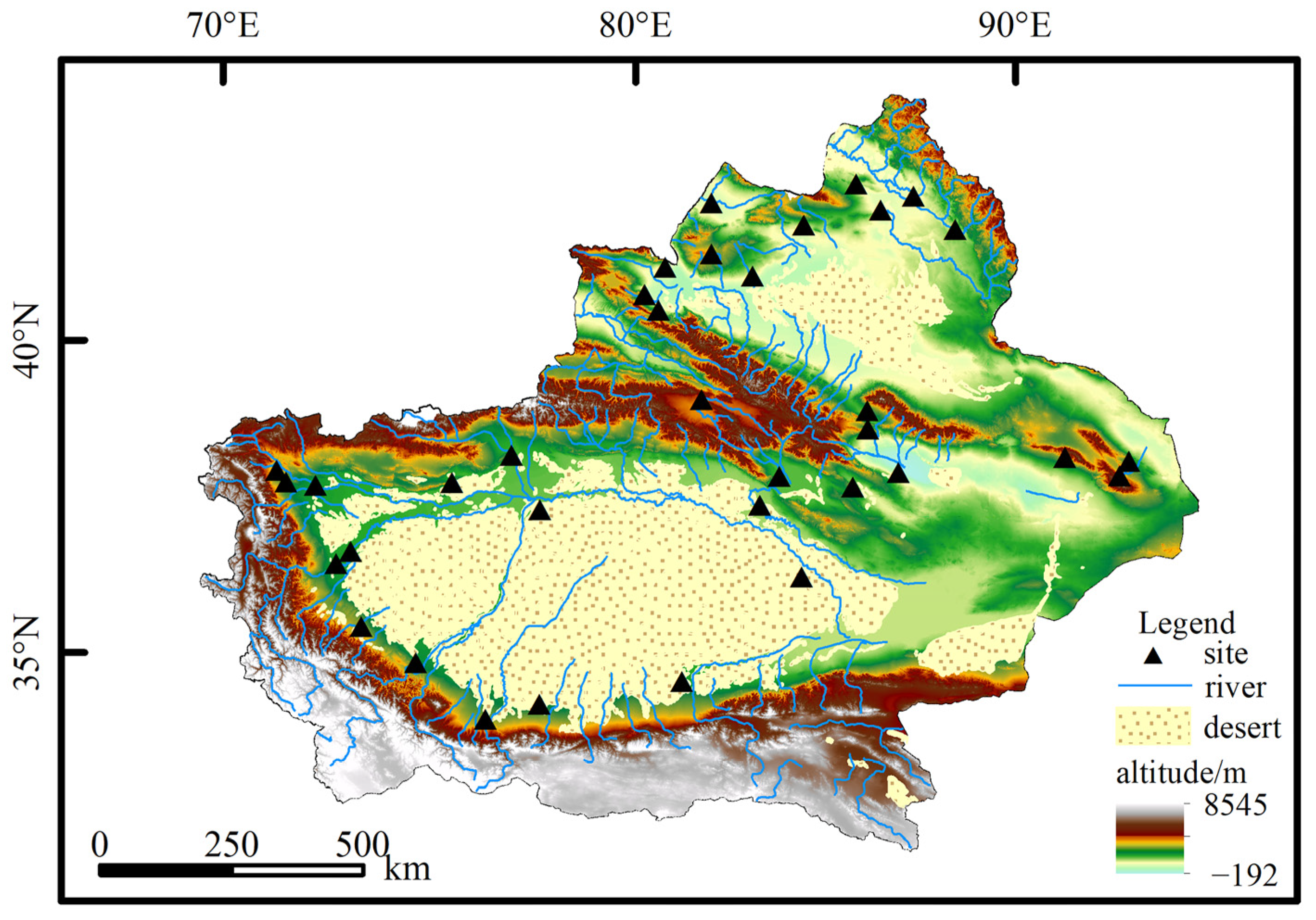
Figure 1. Geography and meteorological stations of Xinjiang.
Atmosphere 13 01067 g001
Figure 2. Trend in extreme dry/wet events by year (a,b), spring (c,g), summer (d,h), autumn (e,i) and winter (f,j) in Xinjiang from 1960 to 2020.
Atmosphere 13 01067 g002
Figure 3. Trend in extreme drought (a,c) and wet (b,d) events in northern (a,b) and southern (c,d) Xinjiang from 1960 to 2020.
Atmosphere 13 01067 g003
Figure 4. Spatial distribution of annual frequency of extreme dry (a) and wet (b) events in Xinjiang from 1960 to 2020.
Atmosphere 13 01067 g004
Figure 5. Frequency mutation curves and power spectrum of extreme drought (a,c) and wet (b,d) events in Xinjiang from 1960 to 2020.
Atmosphere 13 01067 g005
Figure 6. Absolute value of the contribution rate of main influencing factors > 15%.
Atmosphere 13 01067 g006
Figure 7. Regression coefficients (a,b) and regression VIP values of the PLS model (c) of extreme wet and dry events in Xinjiang (* is VIP value > 0.8, indicating a significant correlation).
Atmosphere 13 01067 g007
Figure 8. Cross-wavelet transform between extreme dry (left) and wet (right) events and EI Nino in Xinjiang.
Atmosphere 13 01067 g008
Publisher’s Note: MDPI stays neutral with regard to jurisdictional claims in published maps and institutional affiliations.