
State of the Simulation of Mesoscale Winds in the Mediterranean and Opportunities for Improvements


Abstract
:1. Introduction
- For which winds do high-resolution simulations exist and do they provide additional insights?
- Which Mediterranean wind systems have already been studied in detail, and which wind systems have only little data available and appear promising for further study?
- Which grid spacing is needed to resolve phenomena such as gap winds, sea breeze, and wave breaking?
- Which model improvements—besides higher resolution—are needed?
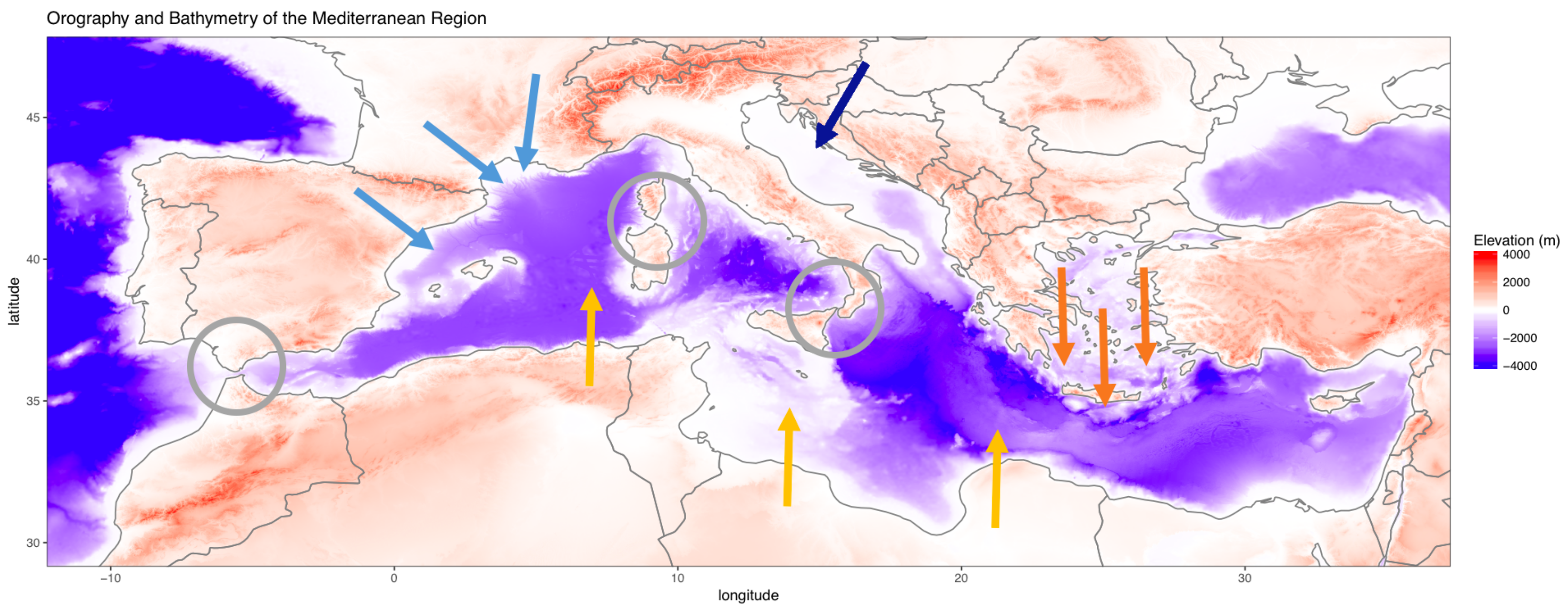
2. Regional Winds
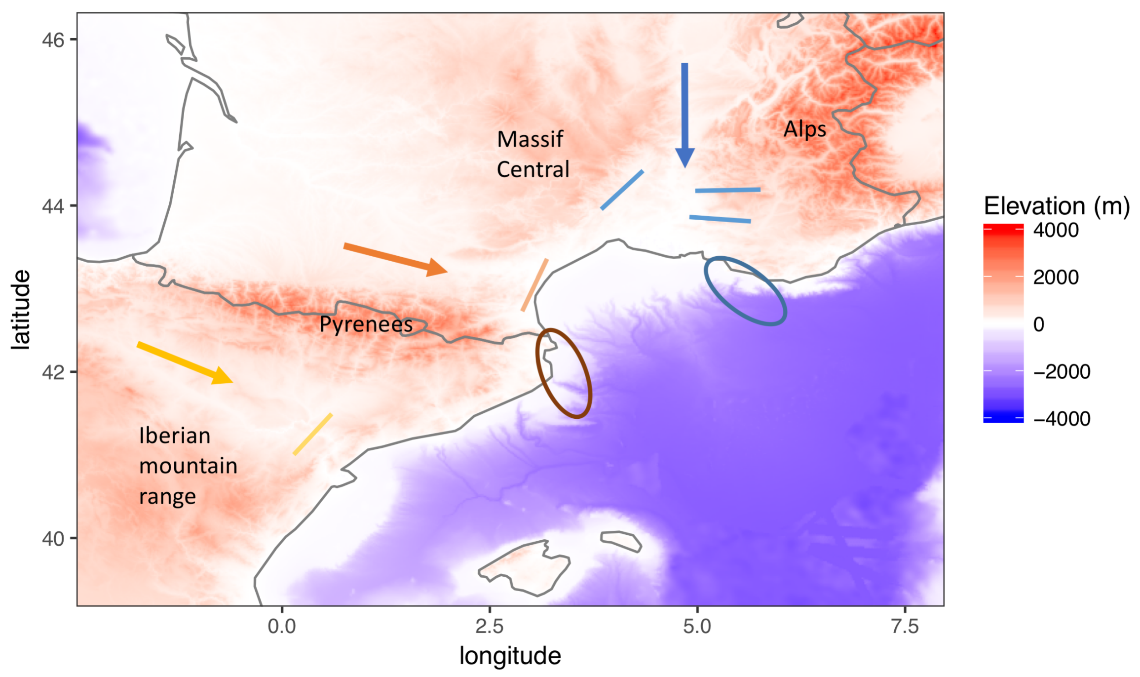
2.1. Winds Channeled in Valleys
2.2. Bora
2.3. Etesians/Meltemi
2.4. Scirocco, Ghibli, and Khamsin
3. Local Wind Systems with Diurnal Cycles
3.1. Sea Breeze and Land Breeze
3.2. Valley Winds
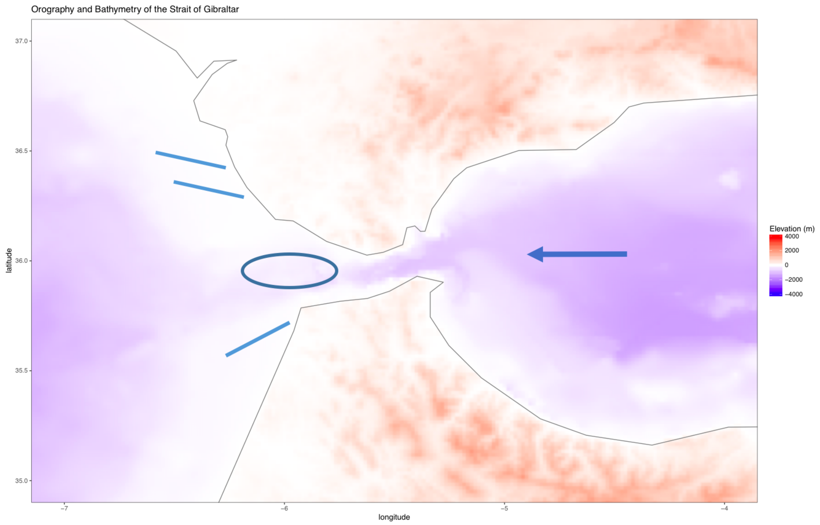
4. Channeling in Straits
- the Strait of Gibraltar between Europe and Africa, which connects the Mediterranean Sea to the Atlantic Ocean;
- the Strait of Bonifacio between Corsica and Sardinia connecting the Tyrrhenian Sea from the Gulf of Lion;
- the Strait of Messina between Sicily and Calabria connecting the Tyrrhenian Sea to the Ionian Sea.
4.1. Strait of Gibraltar
4.2. Strait of Bonifacio
4.3. Other Straits
4.4. Mountain Gap Flows
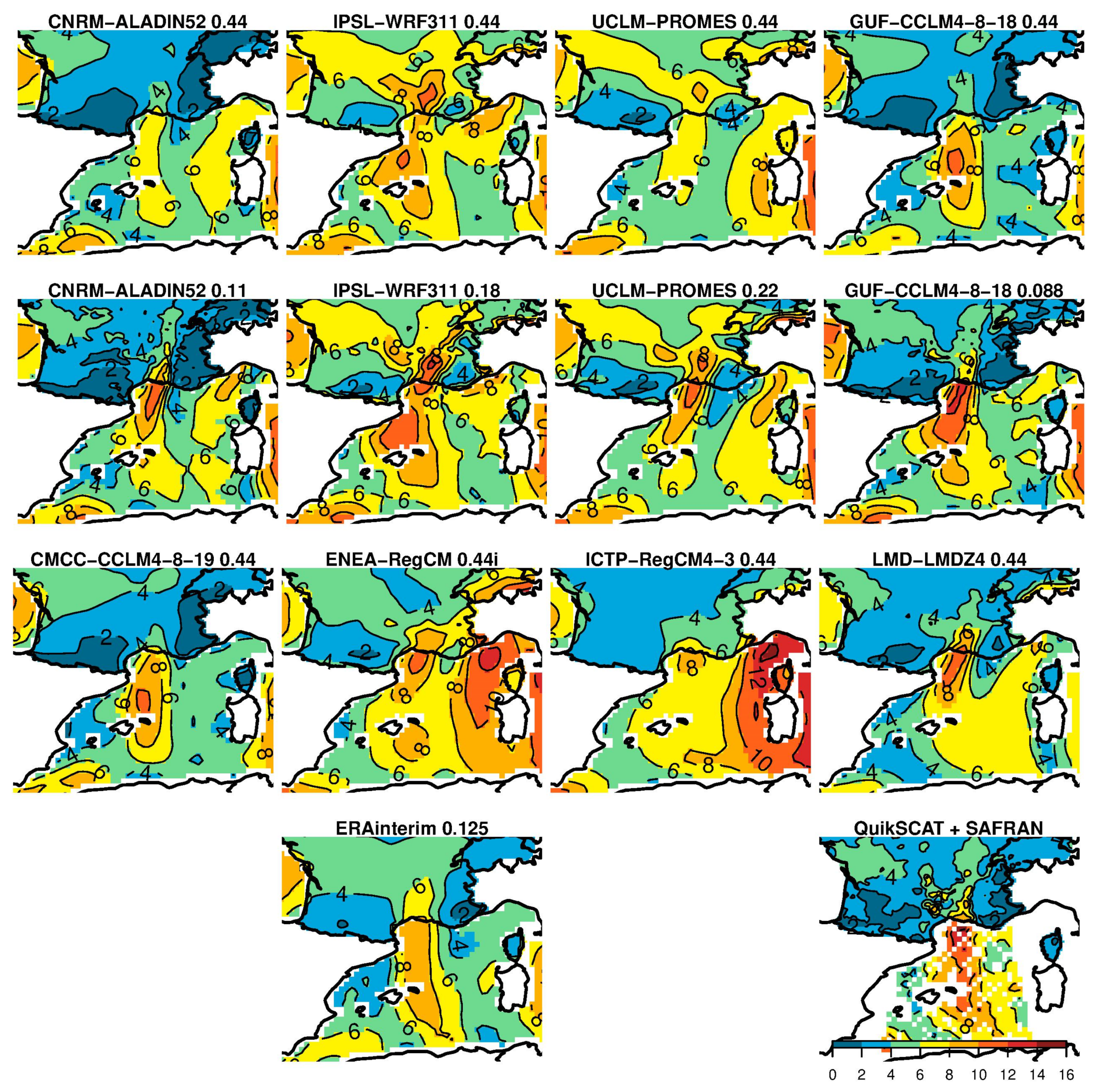
5. Differences between Models
6. Summary and Outlook
Funding
Institutional Review Board Statement
Informed Consent Statement
Data Availability Statement
Conflicts of Interest
Abbreviations
| CORDEX | coordinated regional climate downscaling experiment |
| CPS | convection permitting simulations |
| EURO-CORDEX | European CORDEX |
| GCM | global circulation model |
| Med-CORDEX | Mediterranean CORDEX |
| PBL | planetary boundary layer |
| RCM | regional climate model |
References
- Giorgi, F. Climate change hot-spots. Geophys. Res. Lett. 2006, 33, 1–4. [Google Scholar] [CrossRef]
- Diffenbaugh, N.S.; Giorgi, F. Climate change hotspots in the CMIP5 global climate model ensemble. Clim. Chang. 2012, 114, 813–822. [Google Scholar] [CrossRef] [PubMed] [Green Version]
- Giorgi, F.; Jones, C.; Asrar, G.R. Addressing climate information needs at the regional level: The CORDEX framework. World Meteorol. Organ. Bull. 2009, 58, 175–183. [Google Scholar]
- Giorgi, F.; Gutowski, W.J. Regional Dynamical Downscaling and the CORDEX Initiative. Annu. Rev. Environ. Resour. 2015, 40, 467–490. [Google Scholar] [CrossRef]
- Ruti, P.M.; Somot, S.; Giorgi, F.; Dubois, C.; Flaounas, E.; Obermann, A.; Dell’Aquila, A.; Pisacane, G.; Harzallah, A.; Lombardi, E.; et al. Med-CORDEX initiative for Mediterranean climate studies. Bull. Am. Meteorol. Soc. 2016, 97, 1187–1208. [Google Scholar] [CrossRef] [Green Version]
- Jacob, D.; Petersen, J.; Eggert, B.; Alias, A.; Christensen, O.B.; Bouwer, L.M.; Braun, A.; Colette, A.; Déqué, M.; Georgievski, G.; et al. EURO-CORDEX: New high-resolution climate change projections for European impact research. Reg. Environ. Chang. 2014, 14, 563–578. [Google Scholar] [CrossRef]
- Bastin, S.; Drobinski, P.; Caccia, J.L.; Campistron, B.; Dabas, A.M.; Delville, P.; Reitebuch, O.; Werner, C.; Garde, L. On the interaction between the sea breeze and a summer Mistral event at the exit of the Rhône valley. Mon. Weather Rev. 2006, 134, 1647–1668. [Google Scholar] [CrossRef] [Green Version]
- Capon, R.A. High resolution studies of the Gibraltar Levanter validated using sun-glint anemometry. Meteorol. Appl. 2006, 13, 257–265. [Google Scholar] [CrossRef]
- Prtenjak, M.T.; Viher, M.; Jurković, J. Sea-land breeze development during a summer bora event along the north-eastern Adriatic coast. Q. J. R. Meteorol. Soc. 2010, 136, 1554–1571. [Google Scholar] [CrossRef]
- Grisogono, B.; Belušić, D. A review of recent advances in understanding the meso- and microscale properties of the severe Bora wind. Tellus Ser. A Dyn. Meteorol. Oceanogr. 2009, 61, 1–16. [Google Scholar] [CrossRef]
- Amante, C.; Eakins, B.W. ETOPO1 1 Arc-Minute Global Relief Model: Procedures, Data Sources and Analysis; National Geophysical Data Center: Boulder, CO, USA, 2009; Volume 10, p. V5C8276M. [Google Scholar] [CrossRef]
- Jacq, V.; Albert, P.; Delorme, R. Le mistral. La Météorol. 2005, 50, 30–38. [Google Scholar]
- Obermann, A.; Edelmann, B.; Ahrens, B. Influence of sea surface roughness length parameterization on Mistral and Tramontane simulations. Adv. Sci. Res. 2016, 13, 107–112. [Google Scholar] [CrossRef] [Green Version]
- Masson, V.; Bougeault, P. Numerical Simulation of a Low-Level Wind Created by Complex Orography: A Cierzo Case Study. Mon. Weather Rev. 1996, 124, 701–715. [Google Scholar] [CrossRef] [Green Version]
- Drobinski, P.; Flamant, C.; Dusek, J.A.N.; Flamant, P.H.; Pelon, J. Observational evidence and modelling of an internal hydraulic jump at the atmospheric boundary-layer top during a Tramontane event. Bound. Layer Meteorol. 2001, 98, 497–515. [Google Scholar] [CrossRef]
- Drobinski, P.; Bastin, S.; Guenard, V.; Caccia, J.L.; Dabas, A.M.; Delville, P.; Protat, A.; Reitebuch, O.; Werner, C. Summer mistral at the exit of the Rhône valley. Q. J. R. Meteorol. Soc. 2005, 131, 353–375. [Google Scholar] [CrossRef] [Green Version]
- Simpson, J.E. Sea Breeze and Local Wind; Cambridge University Press: Cambridge, UK, 1994; p. 234. [Google Scholar]
- Drobinski, P.; Alonzo, B.; Basdevant, C.; Cocquerez, P.; Doerenbecher, A.; Fourrié, N.; Nuret, M. Lagrangian dynamics of the mistral during the HyMeX SOP2. J. Geophys. Res. 2017, 122, 1387–1402. [Google Scholar] [CrossRef]
- Guenard, V.; Drobinski, P.; Caccia, J.L.; Campistron, B.; Benech, B. An observational study of the mesoscale mistral dynamics. Bound. Layer Meteorol. 2005, 115, 263–288. [Google Scholar] [CrossRef]
- Giles, B.D. Fluidics, the Coanda Effect, and some orographic winds. Archiv für Meteorol. Geophys. Und Bioklimatol. Ser. A 1977, 25, 273–279. [Google Scholar] [CrossRef]
- Obermann, A.; Bastin, S.; Belamari, S.; Conte, D.; Gaertner, M.A.; Li, L.; Ahrens, B. Mistral and Tramontane wind speed and wind direction patterns in regional climate simulations. Clim. Dyn. 2018, 51, 1059–1076. [Google Scholar] [CrossRef] [Green Version]
- Obermann-Hellhund, A.; Ahrens, B. Mistral and Tramontane Simulations with changing Resolution of Orography. Atmos. Sci. Lett. 2018, 19, e848. [Google Scholar] [CrossRef]
- Obermann-Hellhund, A.; Conte, D.; Somot, S.; Torma, C.Z.; Ahrens, B. Mistral and Tramontane wind systems in climate simulations from 1950 to 2100. Clim. Dyn. 2018, 50, 693–703. [Google Scholar] [CrossRef] [Green Version]
- Riosalido, R.; Vázquez, L.; Gorgo, A.; Jansà, A. Cierzo: Northwesterly wind along the Ebro Valley as a meso-scale effect induced on the lee of the Pyrenees mountain range: A case study during ALPEX Special Observing Period. Sci. Results Alp. Exp. (ALPEX) 1986, 2, 565–575. [Google Scholar]
- Jiménez, P.A.; González-Rouco, J.F.; Montávez, J.P.; García-Bustamantea, E.; Navarro, J. Climatology of wind patterns in the northeast of the Iberian Peninsula. Int. J. Climatol. 2009, 29, 501–525. [Google Scholar] [CrossRef]
- Koletsis, I.; Giannaros, T.M.; Lagouvardos, K.; Kotroni, V. Observational and numerical study of the Vardaris wind regime in northern Greece. Atmos. Res. 2016, 171, 107–120. [Google Scholar] [CrossRef]
- Romanić, D.; Ćurić, M.; Lompar, M.; Jovičić, I. Contributing factors to Koshava wind characteristics. Int. J. Climatol. 2016, 36, 956–973. [Google Scholar] [CrossRef]
- Josipović, L. Die Bora an der kroatischen Adria–Schwerewellenbrechen und Strömungskanalisierungen in Messwerten und Modellsimulationen. Bachelor’s Thesis, Goethe Universität Frankfurt, Frankfurt, Germany, 2018; pp. 1–51. [Google Scholar]
- Belušić Vozila, A.; Güttler, I.; Ahrens, B.; Obermann-Hellhund, A.; Telišman Prtenjak, M. Wind Over the Adriatic Region in CORDEX Climate Change Scenarios. J. Geophys. Res. Atmos. 2019, 124, 110–130. [Google Scholar] [CrossRef] [Green Version]
- Koletsis, I.; Lagouvardos, K.; Kotroni, V.; Bartzokas, A. The interaction of northern wind flow with the complex topography of Crete Island - Part 2: Numerical study. Nat. Hazards Earth Syst. Sci. 2010, 10, 1845–1855. [Google Scholar] [CrossRef]
- Dafka, S.; Xoplaki, E.; Toreti, A.; Zanis, P.; Tyrlis, E.; Zerefos, C.; Luterbacher, J. The Etesians: From observations to reanalysis. Clim. Dyn. 2016, 47, 1569–1585. [Google Scholar] [CrossRef]
- Dafka, S.; Toreti, A.; Luterbacher, J.; Zanis, P.; Tyrlis, E.; Xoplaki, E. On the ability of RCMs to capture the circulation pattern of Etesians. Clim. Dyn. 2017, 51, 1687–1706. [Google Scholar] [CrossRef]
- Lorenz, V. Evaluation of Etesian Simulations with the Regional Climate Model COSMO-CLM. Ph.D. Thesis, Goethe-Universität Frankfurt, Frankfurt, Germany, 2018. [Google Scholar]
- Warner, T.T. African deserts. In Desert Meteorology; Cambridge University Press: Cambridge, UK, 2009; pp. 79–104. [Google Scholar]
- Miller, S.T.; Keim, B.D.; Talbot, R.W.; Mao, H. Sea breeze: Structure, forecasting, and impacts. Rev. Geophys. 2003, 41. [Google Scholar] [CrossRef] [Green Version]
- Vovk, O. Land-See- Windsysteme in Scatterometerdatensätzen. Bachelor’s Thesis, Goethe-Universität Frankfurt, Frankfurt, Germany, 2016. [Google Scholar]
- Drobinski, P.; Bastin, S.; Arsouze, T.; Béranger, K.; Flaounas, E.; Stéfanon, M. North-western Mediterranean sea-breeze circulation in a regional climate system model. Clim. Dyn. 2018, 51, 1077–1093. [Google Scholar] [CrossRef] [Green Version]
- Naor, R.; Potchter, O.; Shafir, H.; Alpert, P. An observational study of the summer Mediterranean Sea breeze front penetration into the complex topography of the Jordan Rift Valley. Theor. Appl. Climatol. 2017, 127, 275–284. [Google Scholar] [CrossRef]
- Azorin-Molina, C.; Tijm, S.; Ebert, E.E.; Vicente-Serrano, S.M.; Estrela, M.J. High Resolution HIRLAM Simulations of the Role of Low-Level Sea-Breeze Convergence in Initiating Deep Moist Convection in the Eastern Iberian Peninsula. Bound. Layer Meteorol. 2014, 154, 81–100. [Google Scholar] [CrossRef] [Green Version]
- Giovannini, L.; Laiti, L.; Serafin, S.; Zardi, D. The thermally driven diurnal wind system of the Adige Valley in the Italian Alps. Q. J. R. Meteorol. Soc. 2017, 143, 2389–2402. [Google Scholar] [CrossRef]
- Zavatarelli, M.; Pinardi, N.; Zavatarelli, M.; The, N.P.; Sea, A. The Adriatic Sea modelling system: A nested approach. Ann. Geophys. 2003, 21, 345–364. [Google Scholar] [CrossRef]
- Béranger, K.; Mortier, L.; Crépon, M. Seasonal variability of water transport through the Straits of Gibraltar, Sicily and Corsica, derived from a high-resolution model of the Mediterranean circulation. Prog. Oceanogr. 2005, 66, 341–364. [Google Scholar] [CrossRef]
- De Falco, G.; De Muro, S.; Batzella, T.; Cucco, A. Carbonate sedimentation and hydrodynamic pattern on a modern temperate shelf: The strait of Bonifacio (western Mediterranean). Estuar. Coast. Shelf Sci. 2011, 93, 14–26. [Google Scholar] [CrossRef]
- Gerigny, O.; Di Martino, B.; Romano, J.C. The current dynamics inside the Strait of Bonifacio: Impact of the wind effect in a little coastal strait. Cont. Shelf Res. 2011, 31, 1–8. [Google Scholar] [CrossRef]
- Cucco, A.; Sinerchia, M.; Ribotti, A.; Olita, A.; Fazioli, L.; Perilli, A.; Sorgente, B.; Borghini, M.; Schroeder, K.; Sorgente, R. A high-resolution real-time forecasting system for predicting the fate of oil spills in the Strait of Bonifacio (western Mediterranean Sea). Mar. Pollut. Bull. 2012, 64, 1186–1200. [Google Scholar] [CrossRef]
- Cucco, A.; Quattrocchi, G.; Olita, A.; Fazioli, L.; Ribotti, A.; Sinerchia, M.; Tedesco, C.; Sorgente, R. Hydrodynamic modelling of coastal seas: The role of tidal dynamics in the Messina Strait, Western Mediterranean Sea. Nat. Hazards Earth Syst. Sci. 2016, 16, 1553–1569. [Google Scholar] [CrossRef] [Green Version]
- Battaglia, P.; Ammendolia, G.; Cavallaro, M.; Consoli, P.; Esposito, V.; Malara, D.; Rao, I.; Romeo, T.; Andaloro, F. Influence of lunar phases, winds and seasonality on the stranding of mesopelagic fish in the Strait of Messina (Central Mediterranean Sea). Mar. Ecol. 2017, 38, e12459. [Google Scholar] [CrossRef]
- Scorer, R.S. Mountain-gap winds; a study of surface wind at Gibraltar. Q. J. R. Meteorol. Soc. 1952, 78, 53–61. [Google Scholar] [CrossRef]
- Dorman, C.E.; Beardsley, R.C.; Limeburner, R. Winds in the strait of gibraltar. Q. J. R. Meteorol. Soc. 1995, 121, 1903–1921. [Google Scholar] [CrossRef]
- Zecchetto, S.; De Biasio, F. Sea surface winds over the Mediterranean basin from satellite data (2000–04): Meso- and local-scale features on annual and seasonal time scales. J. Appl. Meteorol. Clim. 2007, 46, 814–827. [Google Scholar] [CrossRef]
- Muth, L. Strömungskanalisierung in der Straße von Bonifacio. Bachelor’s Thesis, Goethe Universität Frankfurt, Frankfurt, Germany, 2016. [Google Scholar]
- Lavagnini, A.; Sempreviva, A.M.; Transerici, C.; Accadia, C.; Casaioli, M.; Mariani, S.; Speranza, A. Offshore wind climatology over the mediterranean Basin. Wind Energy 2006, 9, 251–266. [Google Scholar] [CrossRef]
- Dee, D.P.; Uppala, S.M.; Simmons, A.J.; Berrisford, P.; Poli, P.; Kobayashi, S.; Andrae, U.; Balmaseda, M.A.; Balsamo, G.; Bauer, P.; et al. The ERA-Interim reanalysis: Configuration and performance of the data assimilation system. Q. J. R. Meteorol. Soc. 2011, 137, 553–597. [Google Scholar] [CrossRef]
- Lungu, T.; Dunbar, S.; Weiss, B.; Stiles, B.; Huddleston, J.; Callahan, P.; Shirtliffe, G.; Perry, K.L.; Hsu, C.; Mears, C.; et al. QuikSCAT Science Data Product User’s Manual: Overview and Geophysical Data Products. Jet Propuls. Lab. 2006, 3, 91. [Google Scholar]
- Vidal, J.P.; Martin, E.; Franchistéguy, L.; Baillon, M.; Soubeyroux, J.M. A 50-year high-resolution atmospheric reanalysis over France with the Safran system. Int. J. Climatol. 2010, 30, 1627–1644. [Google Scholar] [CrossRef] [Green Version]
- Quintana-Seguí, P.; Le Moigne, P.; Durand, Y.; Martin, E.; Habets, F.; Baillon, M.; Canellas, C.; Franchisteguy, L.; Morel, S. Analysis of near-surface atmospheric variables: Validation of the SAFRAN analysis over France. J. Appl. Meteorol. Climatol. 2008, 47, 92–107. [Google Scholar] [CrossRef]
- Obermann-Hellhund, A. Mistral and Tramontane: Simulation of Mesoscale Winds in Regional Climate Models. Ph.D. Thesis, Goethe-Universität Frankfurt, Frankfurt, Germany, 2017. [Google Scholar]
- Charnock, H. Wind stress on a water surface. Q. J. R. Meteorol. Soc. 1955, 81, 639–640. [Google Scholar] [CrossRef]
- Cohen, A.E.; Cavallo, S.M.; Coniglio, M.C.; Brooks, H.E. A review of planetary boundary layer parameterization schemes and their sensitivity in simulating southeastern U.S. cold season severe weather environments. Weather Forecast. 2015, 30, 591–612. [Google Scholar] [CrossRef]
- Termonia, P.; Fischer, C.; Bazile, E.; Bouyssel, F.; Brožková, R.; Bénard, P.; Bochenek, B.; Degrauwe, D.; Derková, M.; El Khatib, R.; et al. The ALADIN System and its canonical model configurations AROME CY41T1 and ALARO CY40T1. Geosci. Model Dev. 2018, 11, 257–281. [Google Scholar] [CrossRef] [Green Version]
- Louis, J.F. A parametric model of vertical eddy fluxes in the atmosphere. Bound. Layer Meteorol. 1979, 17, 187–202. [Google Scholar] [CrossRef]
- Cuxart, J.; Bougeault, P.; Redelsperger, J.L. A turbulence scheme allowing for mesoscale and large-eddy simulations. Q. J. R. Meteorol. Soc. 2000, 126, 3055–3079. [Google Scholar] [CrossRef]
- Ricard, J.L.; Royer, J.F. A statistical cloud scheme for use in an AGCM. Ann. Geophys. 1993, 11, 1095–1115. [Google Scholar]
- Mellor, G.L.; Yamada, T. A Hierarchy of Turbulence Closure Models for Planetary Boundary Layers. J. Atmos. Sci. 1974, 31, 1791–1806. [Google Scholar] [CrossRef] [Green Version]
- Bougeault, P.; Lacarrère, P. Parameterization of Orography-Induced Turbulence in a Mesobeta-Scale Model. Mon. Weather Rev. 1989, 117, 1872–1890. [Google Scholar] [CrossRef]
- Sataloff, R.T.; Johns, M.M.; Kost, K.M. Nonlocal Boundary Layer Vertical Diffusion in a Medium-Range Forecast Model. Mon. Weather Rev. 1996, 124, 2322–2339. [Google Scholar]
- Van Meijgaard, E.; von Ulft, L.H.; Lenderink, G.; de Roode, S.R.; Wipfler, L.; Boers, R.; Timmermans, R.M.A. Refinement and Application of a Regional Atmospheric Model for Climate Scenario Calculations of Western Europe; Wageningen University: Wageningen, The Netherlands, 2012; pp. 1–46. [Google Scholar]
- Holtslag, A.A.M.; Bruijn, E.I.F.d.; Pan, H.L. A High Resolution Air Mass Transformation Model for Short-Range Weather Forecasting. Mon. Weather Rev. 1990, 118, 1561–1575. [Google Scholar] [CrossRef]
- Bretherton, C.S.; McCaa, J.R.; Grenier, H. A new parameterization for shallow cumulus convection and its application to marine subtropical cloud-topped boundary layers. Part I: Description and 1D results. Mon. Weather Rev. 2004, 132, 864–882. [Google Scholar] [CrossRef] [Green Version]
- Davies, T.; Cullen, M.J.P.; Malcolm, A.J.; Mawson, M.H.; Staniforth, A.; White, A.A.; Wood, N. A new dynamical core for the Met Office’s global and regional modelling of the atmosphere. Q. J. R. Meteorol. Soc. 2005, 131, 1759–1782. [Google Scholar] [CrossRef]
- Hong, S.Y.; Noh, Y.; Dudhia, J. A new vertical diffusion package with an explicit treatment of entrainment processes. Mon. Weather Rev. 2006, 134, 2318–2341. [Google Scholar] [CrossRef] [Green Version]


| Model | (Non-)Hydrostatic | PBL | Studies |
|---|---|---|---|
| ALADIN | both options [60] | Louis [61] | [21,29,32] |
| AROME | non-hydrostatic | Cuxart [62] | [18] |
| ARPEGE | both options [60] | Ricard and Royer [63] | [32] |
| COSMO-CLM | non-hydrostatic | Mellor-Yamada [64] | [13,21,22,23,28,29,33,51] |
| HIRHAM | hydrostatic | Louis [61] | [29,32] |
| HIRLAM | hydrostatic | Cuxart [62] | [39] |
| LMDZ | hydrostatic | Mellor-Yamada [64] | [21] |
| Méso-NH | non-hydrostatic | BouLac [65] | [7] |
| MM5 | non-hydrostatic | MRF [66] | [16,30] |
| PERIDOT | hydrostatic | BouLac [65] | [14] |
| PROMES | hydrostatic | Cuxart [62] | [21] |
| QBOLAM | hydrostatic | Cuxart [62] | [52] |
| RACMO22E | hydrostatic | Meijgaard [67] | [29] |
| RCA4 | hydrostatic | Cuxart [62] | [29,32] |
| RegCM | hydrostatic | Holtslag [68], UW-PBL [69] | [23,29] |
| REMO | non-hydrostatic | Louis [61], Mellor-Yamada [64] | [29] |
| UM | non-hydrostatic | [70] | [8] |
| WRF | non-hydrostatic | YSU [71] | [9,21,26,32,37] |
| Location | Wind System | RCM Grid Spacing | Other Studies | |
|---|---|---|---|---|
| ≈12–25 km | ≈1–3 km | |||
| Regional Winds | ||||
| Rhone Valley | Mistral | [13,18,21,23] | [7,16] | [12,19,20,22] |
| Aude Valley | Tramontane | [13,18,23] | [12,15,22] | |
| Ebro Valley | Cierzo | [14] | [24] | |
| Ebro Valley | Bochorno | [25] | ||
| Axios Valley | Vardaris | [26] | ||
| Adriatic region | Bora | [28,29] | [10,28] | [10] |
| Aegan Sea | Etesians/Meltemi | [32] | [30,33] | [31] |
| Coast of Africa | Scirocco, Ghibli… | [34] | ||
| Danube Valley | Koshava | [27] | ||
| Winds with diurnal cycle | ||||
| Coast | Sea/land breeze | [18,37] | [7,9,39] | [17,35,36,38] |
| Valleys | Valley winds | [40] | ||
| Channeling in Straits | [52] | |||
| Gibraltar | Levanter/Poniente | [8] | [42,48,49] | |
| Bonifacio | Libeccio/Gregale | [51] | [42,43,44,45] | |
| Messina | [42,46,47] | |||
| Sicily channel | [42] | |||
| Otranto | [41] | |||
| Mountain gap flows | ||||
| Crete | [30] | |||
| Danube Valley | Koshava | [27] | ||
| Resolved Phenomena | Simulation Type | Grid (km) |
|---|---|---|
| large scale sea level pressure patterns driving regional winds | GCM | ≈100 |
| regional wind patterns | RCM low resolution | ≈50 |
| regional wind patterns improved, gap winds, sea breeze | RCM high resolution | ≈12–25 |
| small scale features, sea breeze improved, wave breaking, | CPS | ≈1–3 |
| flow around islands, channeling in straits, narrow mountain gaps |
Publisher’s Note: MDPI stays neutral with regard to jurisdictional claims in published maps and institutional affiliations. |
© 2022 by the author. Licensee MDPI, Basel, Switzerland. This article is an open access article distributed under the terms and conditions of the Creative Commons Attribution (CC BY) license (https://creativecommons.org/licenses/by/4.0/).
Share and Cite
Obermann-Hellhund, A. State of the Simulation of Mesoscale Winds in the Mediterranean and Opportunities for Improvements. Atmosphere 2022, 13, 1007. https://doi.org/10.3390/atmos13071007
Obermann-Hellhund A. State of the Simulation of Mesoscale Winds in the Mediterranean and Opportunities for Improvements. Atmosphere. 2022; 13(7):1007. https://doi.org/10.3390/atmos13071007
Chicago/Turabian StyleObermann-Hellhund, Anika. 2022. "State of the Simulation of Mesoscale Winds in the Mediterranean and Opportunities for Improvements" Atmosphere 13, no. 7: 1007. https://doi.org/10.3390/atmos13071007
APA StyleObermann-Hellhund, A. (2022). State of the Simulation of Mesoscale Winds in the Mediterranean and Opportunities for Improvements. Atmosphere, 13(7), 1007. https://doi.org/10.3390/atmos13071007