Article

Drop Size Distribution Measurements in Outer Rainbands of Hurricane Dorian at the NASA Wallops Precipitation-Research Facility

1
Department of Electrical and Computer Engineering, Colorado State University, Fort Collins, CO 80523, USA
2
NASA GSFC Wallops Flight Facility, Wallops Island, VA 23337, USA
3
Science Systems and Applications, Inc., Lanham, MD 20706, USA
*
Author to whom correspondence should be addressed.
Atmosphere 2020, 11(6), 578; https://doi.org/10.3390/atmos11060578
Submission received: 21 April 2020 / Revised: 29 May 2020 / Accepted: 29 May 2020 / Published: 1 June 2020

Abstract

:
Hurricane rainbands are very efficient rain producers, but details on drop size distributions are still lacking. This study focuses on the rainbands of hurricane Dorian as they traversed the densely instrumented NASA precipitation-research facility at Wallops Island, VA, over a period of 8 h. Drop size distribution (DSD) was measured using a high-resolution meteorological particle spectrometer (MPS) and 2D video disdrometer, both located inside a double-fence wind shield. The shape of the DSD was examined using double-moment normalization, and compared with similar shapes from semiarid and subtropical sites. Dorian rainbands had a superexponential shape at small normalized diameter values similar to those of the other sites. NASA’s S-band polarimetric radar performed range height-indicator (RHI) scans over the disdrometer site, showing some remarkable signatures in the melting layer (bright-band reflectivity peaks of 55 dBZ, a dip in the copolar correlation to 0.85 indicative of 12–15 mm wet snow, and a staggering reflectivity gradient above the 0 °C level of −10 dB/km, indicative of heavy aggregation). In the rain layer at heights < 2.5 km, polarimetric signatures indicated drop break-up as the dominant process, but drops as large as 5 mm were detected during the intense bright-band period.

Graphical Abstract

1. Introduction

Hurricane Dorian was an intense tropical cyclone that first made landfall in the Caribbean on 27 August 2019 as a Category 5 hurricane. A few days later, it reached the United States near the Florida coast line. The storm then headed northward along the east coast of the continent while weakening in intensity and subsequently transitioning to a post-tropical cyclone. Dorian’s path included the Delmarva Peninsula (almost as a Category 1 hurricane) with outer rainbands having traversed a well-instrumented validation site at the NASA Wallops Precipitation Research Facility (PRF) [1]. The PRF comprises a network of ground instruments including various types of disdrometers, rain gauges, anemometers, micro rain radars, and NASA’s S-band polarimetric radar, referred to as NPOL, located 38 km away. The NPOL radar made regular observational scans over the ground instruments during the rainband period. In this paper, we examine disdrometer-based drop size distribution (DSD) measurements, rain gauge data, and NPOL radar observations, specifically the range height indicator (RHI) scans along the azimuth over the ground instruments made over a period of 8 h. DSD data were analyzed in terms of the underlying shape of the distributions, and their characteristics are correlated with copolar reflectivity (Zh or dBZ) for horizontal polarization, and differential reflectivity (Zdr) between horizontal and vertical polarizations. Pluvio rain gauge data were used for providing rainfall rates to compare against the DSD-based rain rates.
Tropical cyclones are often characterized by a high concentration of small- and medium-sized drops. Several airborne measurements within the eyewall regions and rainbands were previously reported [2,3,4,5]. Apart from disdrometer measurements, dual-polarization observations have also been made for a number of hurricane events. A very recent study [6] examined DSD characteristics in the eyewall region of hurricane Harvey using dual-polarization radar observations from the United States (U.S.) weather radar (WSR-88D) network. Didlake and Kumjian [7] studied in detail polarimetric data in the eye wall, and inner and outer rainbands, and found significant differences in the vertical profiles of Zh, Zdr, the copolar correlation coefficient (ρhv), and the specific differential propagation phase (Kdp), both below and above melting level, indicating different microphysical processes. Brown et al. [8] compared Zh, Zdr variability with several microphysical schemes. They found that the measured Zdr (for a given Zh) was much smaller as compared to that of numerical models (i.e., drops were much smaller than those predicted by models). Wolff et al. [9] also examined WSR-88D radar observations during hurricane Harvey, but the main aim there was to assess the use of specific attenuation for estimating rainfall rates.
Modelling rain DSD has been conducted in numerous studies dating back to [10]. There, DSD was modelled in the form of exponential distribution whose slope parameter depends on rainfall intensity. Later, Ulbrich [11] adopted three-parameter gamma distribution to model the measured DSD at shorter time scales of a few minutes. Gamma distribution has been used almost exclusively in numerous studies to model DSD characteristics, with [12] being a more recent example. It has been the basis for retrieving the parameters of the model using polarimetric-radar measurements ([13,14] and references therein).
A number of methods involving scaling-normalization of the DSD [15,16] and the unified approach of Lee et al. [17] termed as double-moment normalization allow for separating DSD in terms of two reference moments along with the generic shape represented by h(x), where x is the scaled diameter [18]. For DSD shapes that exhibit double curvature such as equilibrium-like shapes, the generalized-gamma (GG) model [17,19] with two shape parameters (μ, c) is more flexible. In addition, power-law diameter functions such as mass or mass flux also follow the GG model [20].
In a recent article, Raupach and Berne [21] demonstrated that generic shape h(x) is invariant in stratiform rain, i.e., greater than 85% of DSD variability was captured by the two reference moments (third and the sixth) in the double-moment normalization. Their data analysis also suggested that convective rain DSD possibly exhibits similar behavior. In this paper, we continue with the same double-moment normalization approach, and examine the suitability of the GG model to represent h(x;μ,c) derived from the disdrometer measurements in the rainbands of hurricane Dorian.
The paper is structured as follows. In Section 2, we briefly describe the ground instruments used in this study and S-band NPOL radar observations. DSD examples and data analyses for the entire observation period are presented in Section 3. NPOL observations over the disdrometer site are given in Section 4 and correlated with the results from the DSD analyses in Section 5. This is followed by concluding remarks in Section 6.

2. Instrumentation

Figure 1a shows the composite radar image of hurricane Dorian from the U.S. weather radar network over and around the ground observation site. The site, marked with a “+” sign, is located in the coastal region of the Delmarva peninsula. At the time of this image (around 10:15 UTC on 6 September 2019), the outermost rainbands are clearly visible near the instrument site, whereas the eye of the storm was situated just south of the image frame.
The instrument site is part of the ground validation activities in support of NASA’s global precipitation measurement (GPM) mission [22]. A network of many ground instruments with multiparameter radar observations not only provide pertinent data for validating GPM-based products, but also enable studies on precipitation microphysics. The ground instruments include various types of disdrometers and rain gauges. Here, we utilized data obtained from two disdrometers, namely a meteorological particle spectrometer (MPS) [23,24,25] and a 2D video disdrometer (2DVD) [26,27], as well as a Pluvio rain gauge [28], all collocated at the same coastal region. The MPS was installed within a double wind fence (DFIR) [29] in order to reduce the effects of high winds on DSD measurements. This setup was similar to that of two other sites, one in Greeley, Colorado, and one in Huntsville, Alabama (see Figure 1 of [30]). While the MPS enabled relatively accurate measurements of drop concentration for drop diameters below 1.2 mm, the 2DVD provided more accurate measurements for larger diameters( >0.7 mm). As with Greeley and Huntsville data analyses, we composited drop size distribution from each instrument (typically 3 min averaged) using the MPS for D < Dth and the 2DVD for D ≥ Dth, where Dth is a threshold diameter in the overlap range from 0.75 to 1 mm [31]. Due to high gusting winds, the data quality of the MPS concentrations for D < 0.5 mm could not be firmly established; so, to be conservative, we used 0.5 mm as the lower limit for the MPS. Further Dth was selected as 1 mm; thus, by combining data from two disdrometers, truncation at the small drop end was partially overcome. The composite DSD that resulted was considered to be a substantial improvement over using a single 2DVD alone.
Rainfall rates derived from DSD spectra were compared with Pluvio-based rainfall rates, shown in Figure 1b for the entire day. Both showed fluctuating rain rates (peak rates seemed to be spaced, on average, 45 min apart, so 3 min DSD could adequately resolve the features), as the (main) rainbands traversed the instrument site from 11:00 to 19:00 UTC. Figure 1c shows mass -weighted mean diameter Dm derived from the composite DSDs (ratio of fourth to third moments). As seen, values of Dm > 2 mm occurred several times during the event, with a maximal value of 2.5 mm at around 15:45 UTC. Rain rates (3 min averaged), on the other hand, reached a maximum (~12 mm/h) earlier, at around 14:20 UTC.
The NPOL radar was used for continuous observations during the main part of the event. This radar is a unique and valuable resource for both NASA Earth sciences and external communities. The antenna system provides for better than 1° beam width and electrical performance (side lobe and cross-polar patterns) consistent with the collection of research-quality polarimetric data. The radar signal processor was upgraded to the SIGMET/Vaisala RVP-900. The processor provided a robust means to collect and process raw I/Q (in-phase and quadrature-phase) and moment data in both conventional alternating (full covariance matrix) and simultaneous transmit/receive modes.
The locations of the NPOL radar and the instrument site at Wallops island are shown in Figure 1d. Blue circles represent a radar range of up to 75 km in steps of 25 km. The disdrometer site is marked in orange (WFF).
During the Dorian event, the scan strategy comprised a sequence of (a) PPI (plan position indicator) volume scans with 12 different elevations ranging from 0.7 to 20°; (b) RHI scans with azimuths of 195, 197, and 199°; and (c) vertical (birdbath) scans with two revolutions at 90° for Zdr calibration. In this paper, we made use of RHI scans made along the 197° azimuth along which the disdrometer site was located (37 km). The overall sequence of PPI, RHI, and birdbath scans was repeated every 7 min 15 s.

3. DSD Analysis

3.1. Double-Moment Normalization

To analyze DSDs, we used the double-moment normalization approach of Lee et al. [17], given by:
N ( D ) =   N 0   h ( x ) ,
where
N 0 =   M i ( j + 1 ) ( j i )   M j ( i + 1 ) ( i j )  
and
x = D D m .
D being the equivolume drop diameter, and D m given by:
D m = ( M j M i ) 1 ( j i ) .
This is a generalization of Testud et al. [16], and Illingworth and Blackman [32]. To be consistent with our previous analyses of the Greeley (GXY) and Huntsville (HSV) datasets, we chose the third and fourth moments as the two reference moments by setting i = 3 and j = 4. Under these conditions, D m is equal to Dm (henceforth used interchangeably) and NW = (44/6) M3/(Dm4), as in [16], where M3 is the third moment.
Examples of h(x) versus x are shown in the four panels of Figure 2 that were derived from the 3 min DSDs during (a) 00:00–01:00, (b) 12:00 –13:00, (c) 14:00–15:00, and (d) 16:00–17:00 UTC. The last three panels correspond to the main rainbands, whereas the first panel corresponds to a small fragment of an isolated cell that became detached from the outer bands. All four showed similar shapes, although the first panel showed more scatter because of the limited number of DSD samples. Each plot had the composite, i.e., the most probable h(x) superimposed in red that was previously derived from the GXY and HSV datasets (inclusive of convective and stratiform rain [31]). The composite h(x) corresponds to the GXY and HSV datasets with more than 4000 3 min DSDs from a variety of rain types, from semi-arid and subtropical climates, with each DSD being fitted to the generalized gamma model (see Section 3.2). The median values of the shape parameters were then used to determine the composite h(x).
Good agreement can be seen in Figure 2b,c for x = 0.25 to x = 2. Beyond x = 2, sampling errors may play a role, but consistent underestimation is seen. Even though the minimal D was set at 0.5 mm for MPS data acquired during Dorian rainbands, the corresponding x could go as low as 0.25 (when Dm = 2 mm). Overall, for the main period of the rainbands (10:00–17:00 UTC), the h(x) for 0.25 ≤ x ≤ 2 appears to be fairly well-represented by the most probable h(x) shown by the red diamonds. Further ongoing improvements to the data quality of the MPS measurements during the rainbands might allow for reducing the minimal D to < 0.5 mm, and it is entirely possible that the composite h(x) may require adjustment for rainbands associated with land-falling hurricanes [7,8]. The form of this adjustment could be related to the shape parameters (μ, c) of the generalized gamma model fit to h(x) [33]. Figure 2d corresponds to the end of the rainband passage over the Wallops site. Here, the shape of h(x) showed some differences, particularly in the x = 0.5 to 1 region, where more flattened variation was observed.
The double-moment normalized spectra from 06:00 to 20:00 UTC are all plotted in Figure 3a. There was considerable similarity with Figure 7a in [17], which also used i = 3 and j = 4. The composite h(x) (from GXY and HSV, plotted as red diamonds in Figure 2) is also shown. Black points represent the h(x) derived from 3 min DSD data in the outer bands of hurricane Irma that produced 8 h of rainfall at the HSV site. These are in reasonable agreement with data from the Dorian rainbands, although the composite h(x) lay slightly closer to Irma than Dorian data, especially for x > 2. A color-intensity plot of the Dorian-based h(x) is shown in Figure 3b with the composite h(x) curve from HSV and GXY; once again, the agreement for 0.25 < x < 2.0 is very close.
To illustrate this more quantitatively, in Figure 4 we show the boxplot of the resulting bias (defined as Δ = Dorian − “reference”) in drop concentration, N(D), expressed in terms of relative bias (Δ/mean(“reference”)), if we assume the h(x) derived for the GXY and HSV data is the “truth”. Recall that N(D) = N0’ h(x). The central mark is the median, edges represent the 25th and 75th percentiles, and outliers are plotted individually. Up to 4 mm drop diameters, the relative bias was less than 50%, although the median values tended to be slightly positive (x-axis scale is not uniform). Between 0.5 and 4 mm, the use of the most probable h(x) from GXY and HSV especially resulted in very close representation of the Dorian DSDs. With the caveats mentioned earlier with reference to high gusting winds affecting concentrations for D < 0.5 mm, the use of the composite h(x) results in underestimation of Dorian drop concentrations by about 20–30% (except for the smallest size considered here, which may have had relatively large measurement errors associated with them).

3.2. Generalized Gamma Fits

Now we examine whether the measured DSDs could be fitted to the generaligamma (GG) model [17,21,33]. This basically entails h(x) in Equation (1) to be expressed in terms of the two chosen reference moments with two shape parameters (μGG, c). Following the same notation as that of Lee et al. [17], h(x) is expressed as:
h GG ( i , j , μ , c ) ( x ) = c   Γ i ( j + c μ GG ) ( i j )   Γ j ( i c μ GG ) ( i j )     x c μ GG 1   exp [ ( Γ i Γ j ) c ( i j )   x c ]  
with
Γ i =   Γ ( μ GG + i c )
and
Γ j =   Γ ( μ GG + j c )
i = 3; j = 4
The optimal values of μGG and c were obtained by minimizing the sum of squared difference between log10 (hGG) and the log10 of double-moment normalized composite N(D) using global search.
Four examples are shown in Figure 5, where 5 min DSDs were used for the fitting. The averaging over 5 min corresponded to a spatial scale of 1.2 km assuming the rainbands were advecting at 4 m/s. Figure 5a,b shows the measured DSDs and the fitted curves for two time intervals during the main passage of the rainbands over the site. The fitted μGG values were slightly negative (−0.32 and −0.38, respectively) and values of c are 3.51 and 3.71, respectively. These are somewhat similar to the composite combination of (μGG = −0.25, c = 4) derived from the joint GXY and HSV data analyses. The slightly more negative μGG values seen with Dorian DSD indicate, once again, the modest higher drop concentration of small drops. The standard gamma (SG) from [11] is equivalent to Equation (5) with c = 1 and μGG = μSG − 1; given that our fitted c values were very different from 1, the SG is clearly not sufficiently accurate to represent Dorian DSD measurements. Collocated micro-rain-radar (MRR) [34] observations for each of the four panels are included as an inset. The height along the y-axis ranged from 0 to 1.25 km, and the time along the x-axis spanned 1 h. Effective radar reflectivity Ze (K-band, 24 GHz) was fairly uniform with height in Figure 5a,b.
Figure 5c shows an example where even the GG model was unable to represent the measured DSDs with high fidelity. This occurred at 08:00 UTC just prior to the passage of the main rainbands. During this period, a small but noticeable plateau region in N(D) was observed for drop sizes in the range of 1–1.5 mm. It was not clear whether this was due to some discontinuity between MPS and 2DVD near 1 mm (recall that MPS concentrations were composited with the 2DVD at 1 mm). However, MRR showed a rapid increase in reflectivity below 500 m down to ground level (increase from 20 to 40 dBZ) indicating low-level growth, presumably due to efficient coalescence process. In contrast, Figure 5a,b shows much more uniform reflectivity–height variation during the main rainband passage, consistent with stratiform rain with a bright band.
Figure 5d at 18:00 UTC corresponds to the near end of the rainbands over the disdrometer site. A decrease in drop concentration was seen below 1 mm drop diameter. A similar feature was observed during tropical depression Nate over HSV, again towards the end of the event (for an example, see Figure 7d of [35]). One reason for this could be an intrusion of drier air behind the rainbands causing significant evaporation of small drops. The MRR plot shows the reflectivity profiles becoming shallower with time. The fitted GG curve closely represented the measured DSD, but the fitted μ value was significantly positive (>2) reflecting the convex down shape at the small drop end, and the fitted c-value was around 1.8, which was lower than the c = 4 derived for the GXY-HSV datasets. Hence, for such cases, one would not expect the composite underlying shape to accurately represent the DSDs.

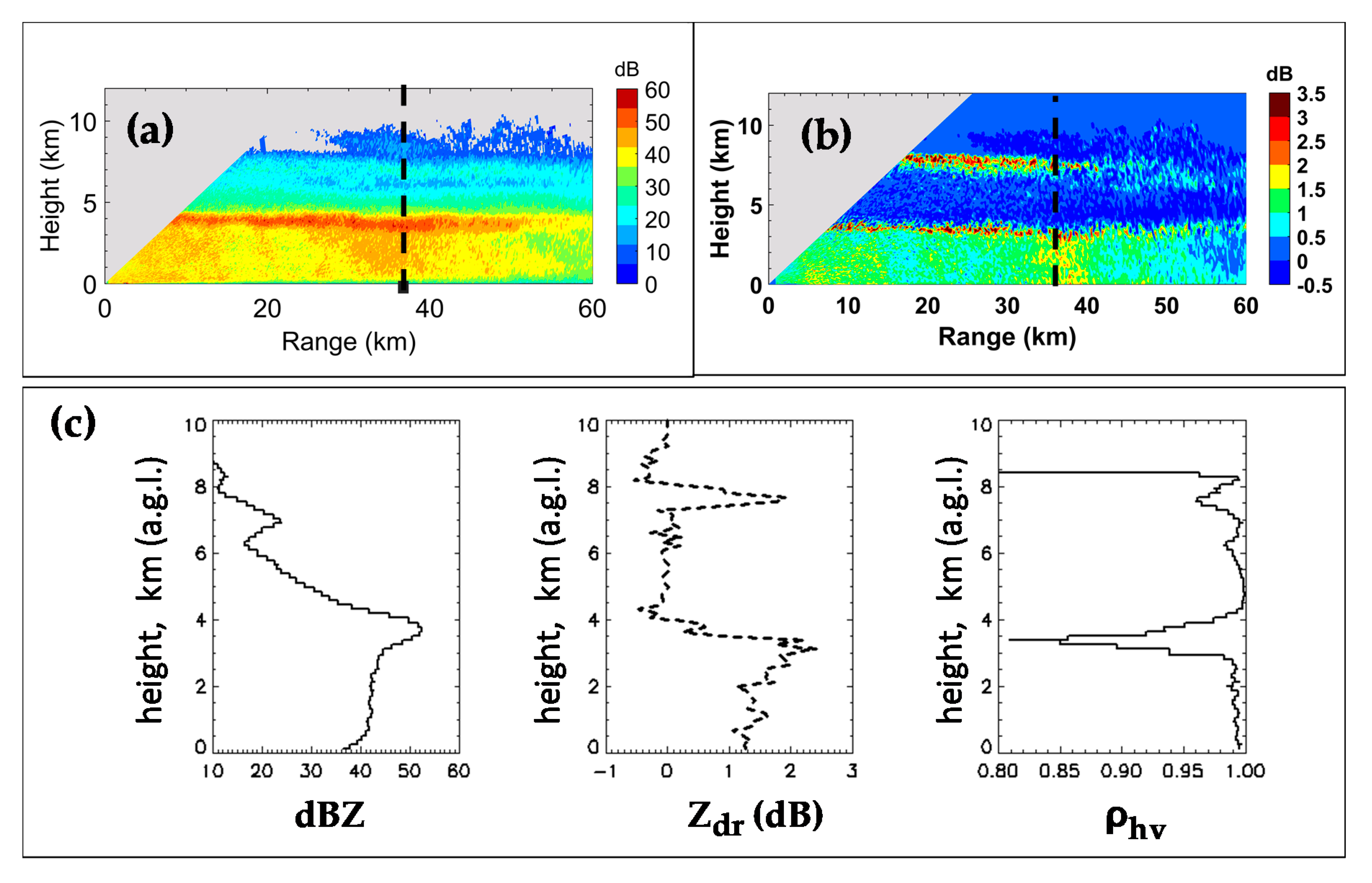
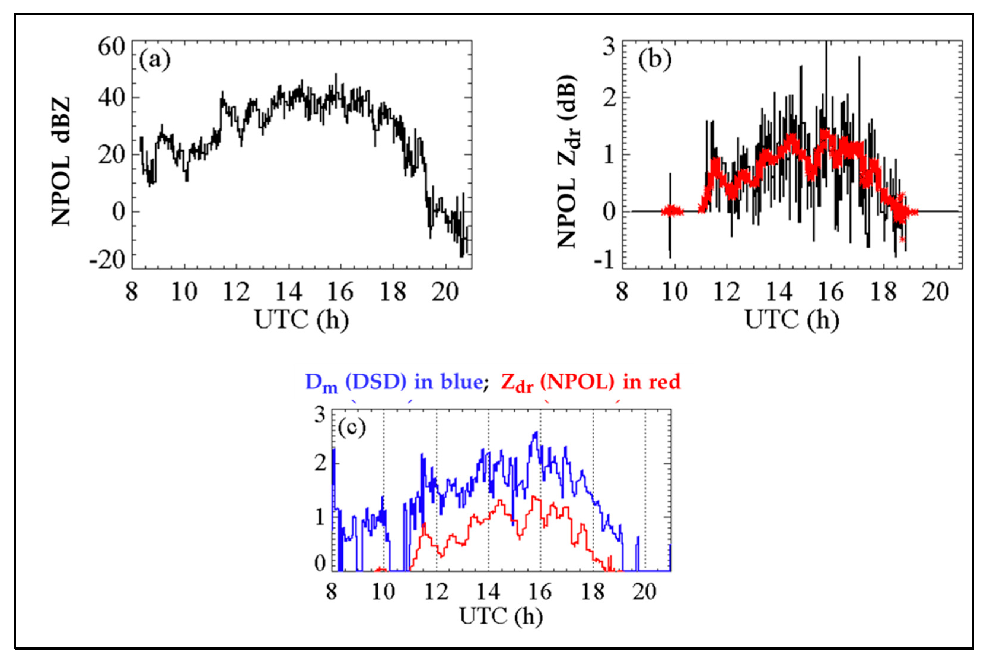
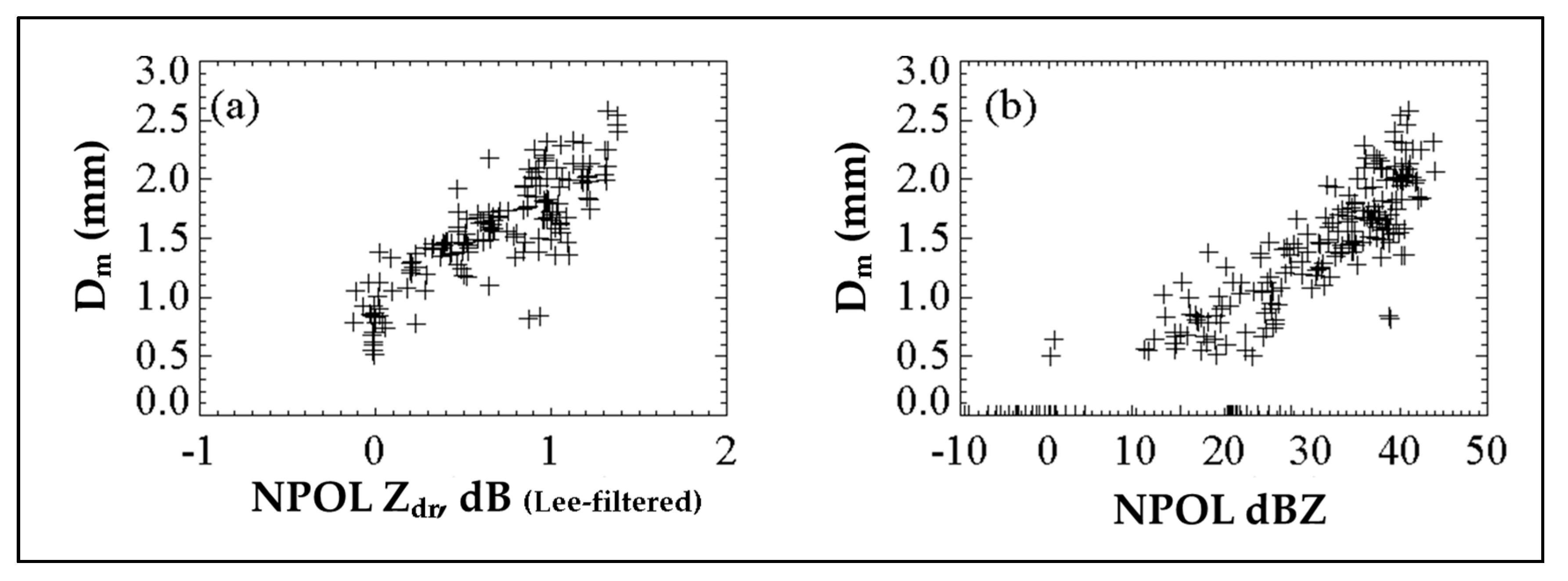
4. NPOL Radar Observations

Figure 6a,b shows the Zh and Zdr from NPOL RHI scan taken along the azimuth of the disdrometer site at 15:41 UTC, which was around the time when Dm from the ground-based DSDs reached a maximal value of almost 2.5 mm. Figure 6c shows height variations above the disdrometer site (data averaged over a 1 km range interval centered at 38 km range). The range to the disdrometer site is marked by a vertical black dashed line. The bright-band (BB) was clearly visible at 4 km AGL in Zh, but significantly less visible in Zdr (i.e., smaller enhancement in the bright band relative to rain below). The Wallops sounding at 15:00 UTC showed that the height of the 0 °C was 4.4 km, surface temperature was 22 °C, and relative humidity was 94%. A remarkable feature was the high value of peak Zh in the BB (nearly 55 dBZ) with around 11 dB fall off in the rain below. The vertical extent of the bright band (in Zh) was quite deep, around 750 m over the disdrometer site. These values are unusual relative to the statistics derived in [36], although their study utilized an X-band radar. Drops as large as 5 mm were recorded by the 2DVD. Gatlin et al. [37] found that stratiform rain with a thick bright band (often associated with larger melting snow particles) tends to produce larger drops; even so, 5 mm drops are relatively rare in non-convective events.
The height variation of Zdr was also remarkable, varying nearly linearly from 0 dB at 4 km AGL (top of melting layer) to 1.5 dB at 3 km (bottom of the melting layer) with no obvious peak in between. The dip in ρhv to 0.85 at 3.5 km AGL was also quite unusual at the S-band, but was observed by Illingworth and Caylor [38], who found the mode to be around 0.9. Zrnic et al. [39] found dips in ρhv to 0.82 in the stratiform region of a mesoscale convective system (MCS), and ascribed it to large wet snow of maximal sizes of around 12 mm. Carlin and Ryzhkov [40] showed that, using a 1D bin-resolved melting model, bright-band thickness and maximal bright band Z (and, by inference, the ρhv dip) were all sensitive to the ambient environment (lapse rate and humidity at 0 °C), while differential reflectivity Zdr was relatively insensitive. Taken together (ΔZh of 12 dB, the deep minima in ρhv and the absence of a distinct peak in Zdr at the base of the ML relative to rain below), the simulations of [40] indicated that lapse rates could be <−6.5°/km with relative humidity (RH) close to 100% at 0 °C. From the sounding at 15:00 UTC at Wallops, lapse rate from surface to 3.5 km was −5 °C/km and RH at 0 °C was 98%. Riming and aggregation, which is not unusual in the humid environment of hurricane rainbands, cannot be excluded. Below the ML, the Zh decreased with decreasing height to the surface by ≈3 dB, while Zdr also decreased from 1.5 to 1 dB. The decreasing trend in both of these parameters indicates that break-up is the dominant process. Another noticeable feature from Figure 6, particularly Figure 6b, is the layer of high Zdr at height of 7.5 km above ground level (−15 °C). This is a well-documented feature that represents the so-called dendritic growth layer that often occurs at temperatures of −10 to −15 °C [41]. The peak in Zdr at 7.5 km is also clearly visible in Figure 6c with a corresponding decrease in ρhv. Below 7 km, a rapid increase in Zh is seen to occur (from 20 dBZ at 6.5 km or −10 °C to 40 dBZ at 4.5 km or 0 °C) or a staggering slope of −10 dB/km, indicative of very strong aggregation process that was also reflected in the maximal Zh of 55 dBZ and ΔZh of 11 dB.

5. Radar Data and DSDs

NPOL data from 08:20 to 21:00 UTC were processed to extract Zh and Zdr over the disdrometer site. From the vertical profiles of Zh and Zdr, for example, Figure 6c, clutter effects were found to be significant up to approximately 300 m above ground level. Figure 7a,b shows the extracted Zh and Zdr at heights ranging from 400 to 600 m above the disdrometer site, and over a range interval from 37 to 39 km. The extracted data were from RHIs over the site, with repeat time of around 7 min shown in panels (a: Zh and b: Zdr). The Zh showed relatively smooth variation with time (a consequence of dB scale with large dynamic range), whereas Zdr showed high pixel-to-pixel fluctuations. Such ‘noise’ could be filtered out either by applying iterative FIR filtering along each range profile (similar to that applied for differential propagation phases [42]) or by applying the so-called “Lee filter” that is a standard technique to reduce speckle noise [43]. Both techniques were compared in our prior studies and shown to give consistent results (e.g., see Figure 2 in [44]). The red curve in Figure 7b shows the Lee-filtered Zdr. Figure 7c shows this same variation (with time) with Dm variation derived from ground-based DSD measurements. Excellent correlation can be seen with Pearson’s correlation coefficient of 0.85.
Figure 8a more clearly shows this variation. Values of 3 min DSD-based Dm were extracted at the time of the NPOL RHI scans over the disdrometer. A clear variation of the NPOL Zdr with Dm is seen, ranging from near zero dB for Dm below 1 mm, to 1.5 dB for Dm as high as 2.5 mm. A similar variation was also found with NPOL reflectivity, as shown in Figure 8b; here, we see an even clearer variation for Dm < 1 mm. For example, for Dm of around 0.5 mm, NPOL data showed reflectivity of ~11 dBZ (range was 10–20 dBZ). This implies that, for light-rain rates (such as drizzle), Zh alone or combined with Zdr can be used to retrieve Dm.

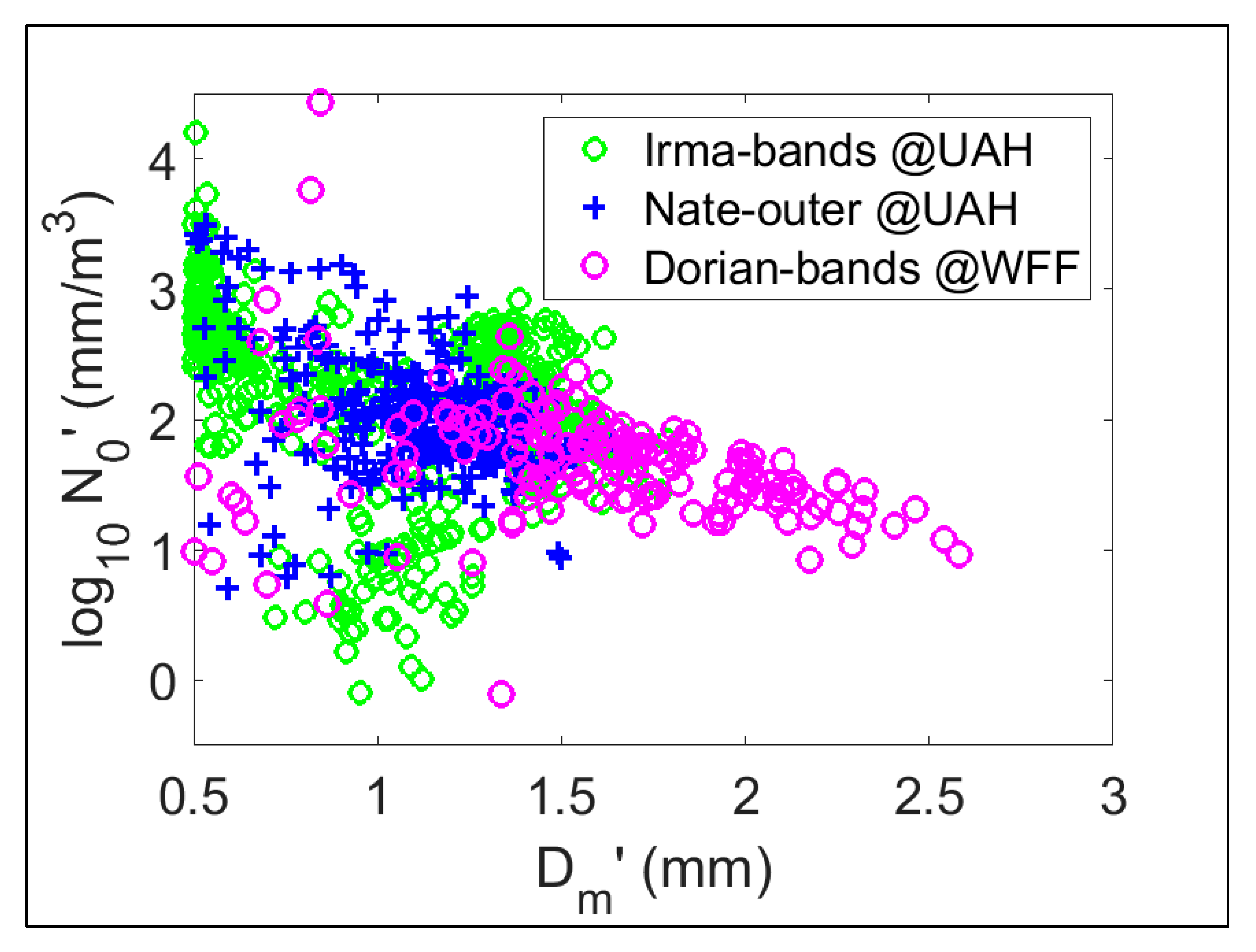
6. Comparisons of DSD Characteristics

The DSD datasets for Dorian’s outer rainbands were obtained from a mid-latitude coastal location. We now compare the DSD characteristics with those from the outer bands of hurricane Irma (Category 1) as well as outer bands of tropical depression Nate, both over HSV, which is an inland subtropical location. Specifically, variations of N0’ versus D m ; were considered. These variations are compared in Figure 9. They all showed stratiform rain characteristics, similar to those found by Bringi et al. [45], which are a near-linear decrease of log10(N0’) with increasing D m . The slope of variation was equivalent to what was found by Bringi et al. [45] for stratiform rain from tropical locations such as Florida to the high plains of Colorado. Their variations were given in terms of NW versus Dm. Using the relationship NW = (44/6) N0’, the gradients in all cases were very similar (almost [1:1] for log10(N0) versus Dm). However, Dorian rainbands generally showed higher Dm than those of the two other cases because of the very large peak Zh in the BB, the large ΔZh, and very strong aggregation inferred above the BB. In contrast, the outer rainbands of Nate showed weak and “thin” BB (peak Zh of around 15–20 dBZ) and at times shallow rain (pure warm rain), while Irma had a peak Zh of around 35–40 dBZ with thickness of <500 m (see, for example, [35]). The corresponding (N0’, D m ) points generally fell in the tropical/subtropical segment of the stratiform rain line of Bringi et al. [45] that was also consistent with these rainbands being sampled at a subtropical location i.e., Huntsville, AL. In contrast, the rainbands of Dorian showed (N0’, D m ) points tracking the stratiform rain line from the subtropical to the mid-latitudes.

7. Conclusions

A detailed description of the rainbands of Category 1 hurricane Dorian as it traversed across the Wallops precipitation research facility was provided from the perspective of the evolution of the DSD spectra and vertical profiles from NPOL radar RHI scan data. The intrinsic shape of the DSD after double-moment normalization using M3 and M4 as the reference moments, termed here as h(x), where x = D/ D m showed that the 3 min DSD-based h(x) was close in shape to the composite h(x) based on over 4000 3 min DSDs from semi-arid Greeley, CO (GXY) and the subtropical Huntsville, AL (HSV) climates. Because of high gusting winds, the minimal D from the MPS was conservatively selected as 0.5 mm, as opposed to 0.1 mm in prior studies. Nevertheless, the use of the MPS for 0.5 ≤ D < 1 mm and the 2DVD for D ≥ 1 mm gave a good indication of the shape at the small drop end. The h(x) from the entire period of the Dorian rainbands was also compared with (i) the average h(x) from the outer rainbands of Irma (8 h of rainfall) and (ii) the most probable h(x) from GXY-HSV with very good agreement for 0.25 ≤ x ≤ 2. The Dorian h(x) was fitted to the generalized gamma (GG) distribution characterized by two shape parameters μGG and c. At time resolution of 5 min, the fitted GG h(x) was un-normalized to obtain a fitted N(D) that was then compared with “raw” DSDs. The fidelity of the GG fit was excellent during the main rainband passage over the site, except at the very beginning and tail end, when the vertical profiles of Zh from the MRR showed no bright band, but more convective features. The beginning time was characterized by low-level growth (coalescence) producing large drops (max D ≈ 4 to 5 mm) whereas the tail-end-fitted N(D) showed a convex down shape for D < 0.5 mm, characteristic of evaporation. During the main rainband passage, the fitted N(D) was excellent, showing the concave up shape at the small drop end, and steeper (than exponential) fall off at the large drop end (max D ≈ 5 mm).
The most remarkable features were the height profiles from NPOL RHI scans over the site. The peak Zh in the melting layer (ML) (bright band or BB peak) was, at times, near 55 dBZ, with ΔZh ≈ 11 dB (difference between BB peak and the rain below). The ρhv dipped to 0.85 in the ML, which was unusual at the S-band and could have only occurred if the backscatter differential phase (δ defined in [13]) varied across the ML, which was indeed the case (not shown here). Zrnic et al. [39] also measured a similar dip in ρhv in the ML of the stratiform region of a mesoscale convective system (MCS), and ascribed it to a variation of δ across the ML caused by large 12–15 mm wet snow. The Zdr profile showed a weak or nonexistent BB peak, but the Zdr increased very rapidly, from near 0 dB at the top of the ML to 1.5 dB within 500 m. The large wet snow melted to form large raindrops, with Dm peaks of 2.5 mm. However, the Nw was a factor of 6 lower than the Marshall–Palmer N0 of 8000 mm−1 m−3 leading to low rain rates of <12 mm/h. The height profile of Zh and Zdr below the ML to the surface indicated break-up as the dominant process (with both δZh and δZdr being negative [46]).
Above the ML, the positive Zdr signature indicating the dendritic growth layer at 7.5 km AGL (T = −15 °C) was observed similar to numerous studies ([14,36] and references therein). The slope of Zh from 6.5 to 4.5 km was a remarkable −10 dB/km, indicating aggregation as the dominant growth process. Together with peak BB Zh of 55 dBZ, the Dorian rainbands were indeed unique.
The NPOL-observed Zh and Zdr extracted over the site were compared with Dm from the measured DSDs both as time series and as scatterplots. The main finding was that Dm could potentially be retrieved using both Zh and Zdr when Dm is small (<1 mm), and perhaps using only Zh for smaller Dm (very light rain rates). Finally, the N0’ versus Dm plot showed that Dorian rainbands followed the stratiform rain line slope from Bringi et al. [45]. As rainbands traversed the site, the N0’ and D m pairs followed the stratiform rain line exhibiting subtropical to midlatitude continental characteristics, unlike the rainbands of tropical depression Nate or the outer bands of Irma over the Huntsville site that were characterized by subtropical stratiform (N0’, Dm) pairs. Detailed analysis of the microphysics of (Category 1) Dorian rainbands demonstrated the value of using collocated MPS and 2DVD for DSD measurements along with polarimetric radar RHI scan data, which should serve as a test bed for validating microphysical process parameterizations such as break-up and aggregation.

Author Contributions

Conceptualization, M.T. and V.N.B.; methodology, investigation, and formal analysis, M.T. and V.N.B.; data curation, D.A.M. and D.B.W.; assistance, C.S.P.; writing—original-draft preparation, M.T.; writing—review and editing, V.N.B., D.B.W., and D.A.M.; supervision, V.N.B.; resources, D.B.W. All authors have read and agreed to the published version of the manuscript.

Funding

M.T. received funding to conduct this research from NASA’s Precipitation Measurement Mission via grant award number 80NSSC19K0676. V.N.B. was funded by the U.S. National Science Foundation under grant AGS190585.

Acknowledgments

We would like to thank Michael Hinton, Brandon Jameson, and several other staff members based at the Wallops Flight Facility for setting up the Meteorological Particle Spectrometer and for enabling data access.

Conflicts of Interest

The authors declare no conflict of interest. The funders had no role in the design of this study; in the collection, analyses, or interpretation of its data; in the writing of this manuscript, and in the decision to publish these results.

References

  1. Wolff, D.B.; Marks, D.A.; Petersen, W.A. 2015: General Application of the Relative Calibration Adjustment (RCA) Technique for Monitoring and Correcting Radar Reflectivity Calibration. J. Atmos. Ocean. Technol. 2015, 32, 496–506. [Google Scholar] [CrossRef]
  2. Merceret, F.J. On the Size Distribution of Raindrops in Hurricane Ginger. Mon. Wea. Rev. 1974, 102, 714–716. [Google Scholar] [CrossRef] [Green Version]
  3. Jorgensen, D.P.; Willis, P.T. A Z–R relationship for hurricanes. J. Appl. Meteorol. 1982, 21, 356–366. [Google Scholar] [CrossRef]
  4. McFarquhar, G.M.; Black, R.A. Observations of particle size and phase in tropical cyclones: Implications for mesoscale modeling of microphysical processes. J. Atmos. Sci. 2004, 61, 422–439. [Google Scholar] [CrossRef] [Green Version]
  5. Tokay, A.; Bashor, P.G.; Habib, E.; Kasparis, T. Raindrop Size Distribution Measurements in Tropical Cyclones. Mon. Wea. Rev. 2008, 136, 1669–1685. [Google Scholar] [CrossRef] [Green Version]
  6. Feng, Y.-C.; Bell, M.M. Microphysical Characteristics of an Asymmetric Eyewall in Major Hurricane Harvey. Geophys. Res. Lett. 2017, 46, 461–471. [Google Scholar] [CrossRef] [Green Version]
  7. Didlake, A.C.; Kumjian, M.R. Examining Polarimetric Radar Observations of Bulk Microphysical Structures and Their Relation to Vortex Kinematics in Hurricane Arthur (2014). Mon. Wea. Rev. 2017, 145, 4521–4541. [Google Scholar] [CrossRef]
  8. Brown, B.R.; Bell, M.M.; Frambach, A.J. Validation of simulated hurricane drop size distributions using polarimetric radar. Geophys. Res. Lett. 2016, 43, 910–917. [Google Scholar] [CrossRef]
  9. Wolff, D.B.; Petersen, W.A.; Tokay, A.; Marks, D.A.; Pippitt, J.L. Assessing Dual-Polarization Radar Estimates of Extreme Rainfall during Hurricane Harvey. J. Atmos. Ocean. Technol. 2019, 36, 2501–2520. [Google Scholar] [CrossRef]
  10. Marshall, J.S.; Palmer, W.M.K. The distribution of raindrops with size. J. Meteorol. 1948, 5, 165–166. [Google Scholar] [CrossRef]
  11. Ulbrich, C.W. Natural Variations in the Analytical Form of the Raindrop Size Distribution. J. Clim. Appl. Meteorol. 1983, 22, 1764–1775. [Google Scholar] [CrossRef] [Green Version]
  12. Williams, C.R.; Bringi, V.N.; Carey, L.D.; Chandrasekar, V.; Gatlin, P.N.; Haddad, Z.S.; Meneghini, R.; Munchak, S.J.; Nesbitt, S.W.; Petersen, W.A. Describing the Shape of Raindrop Size Distributions Using Uncorrelated Raindrop Mass Spectrum Parameters. J. Appl. Meteorol. Climatol. 2014, 53, 1282–1296. [Google Scholar] [CrossRef]
  13. Bringi, V.N.; Chandrasekar, V. Polarimetric Doppler Weather Radar: Principles and Applications; Cambridge University Press: Cambridge, UK, 2001. [Google Scholar]
  14. Ryzhkov, A.; Zrnic, D.S. Radar Polarimetry for Weather Observations; Springer: Chaim, Switzerland, 2019. [Google Scholar]
  15. Sempere-Torres, D.; Porrà, J.M.; Creutin, J.-D. Experimental evidence of a general description for raindrop size distribution properties. J. Geophys. Res. 1998, 103, 1785–1797. [Google Scholar] [CrossRef]
  16. Testud, J.; Oury, S.; Black, R.A.; Amayenc, P.; Dou, X. The concept of “normalized” distribution to describe raindrop spectra: A tool for cloud physics and cloud remote sensing. J. Appl. Meteorol. 2001, 40, 1118–1140. [Google Scholar] [CrossRef]
  17. Lee, G.; Zawadzki, I.; Szyrmer, W.; Sempere-Torres, D.; Uijlenhoet, R. A General Approach to Double-Moment Normalization of Drop Size Distributions. J. Appl. Meteorol. 2004, 43, 264–281. [Google Scholar] [CrossRef] [Green Version]
  18. Yu, N.; Delrieu, G.; Boudevillain, B.; Hazenberg, P.; Uijlenhoet, R. Unified Formulation of Single- and Multimoment Normalizations of the Raindrop Size Distribution Based on the Gamma Probability Density Function. J. Appl. Meteorol. Climatol. 2014, 53, 166–179. [Google Scholar] [CrossRef]
  19. Auf der Maur, A.N. Statistical tools for drop size distribution: Moments and generalized gamma. J. Atmos. Sci. 2001, 58, 407–418. [Google Scholar] [CrossRef]
  20. Petty, G.W.; Huang, W. The modified gamma size distribution applied to inhomogeneous and non-spherical particles: Key relationships and conversions. J. Atmos. Sci. 2011, 68, 1460–1473. [Google Scholar] [CrossRef]
  21. Raupach, T.H.; Berne, A. Retrieval of the raindrop size distribution from polarimetric radar data using double-moment normalization. Atmos. Meas. Tech. 2017, 10, 2573–2594. [Google Scholar] [CrossRef] [Green Version]
  22. Skofronick-Jackson, G.; Petersen, W.A.; Berg, W.; Kidd, C.; Stocker, E.F.; Kirschbaum, D.B.; Kakar, R.; Braun, S.A.; Huffman, G.J.; Iguchi, T.; et al. The Global Precipitation Measurement (GPM) Mission for science and society. Bull. Am. Meteorol. Soc. 2016, 98, 1679–1696. [Google Scholar] [CrossRef]
  23. Knollenberg, R. The optical array: An alternative to scattering or extinction for airborne particle size determination. J. Appl. Meteorol. 1970, 9, 86–103. [Google Scholar] [CrossRef]
  24. Baumgardner, D.; Kok, G.; Dawson, W.; O’Connor, D.; Newton, R. A new ground-based precipitation spectrometer: The Meteorological Particle Sensor (MPS). In Proceedings of the 11th Conference on Cloud Physics, Ogden, UT, USA, 3–7 June 2002. paper 8.6. [Google Scholar]
  25. Bringi, V.N.; Thurai, M.; Baumgardner, D. Raindrop fall velocities from an optical array probe and 2-D video disdrometer. Atmos. Meas. Tech. 2018, 11, 1377–1384. [Google Scholar] [CrossRef] [Green Version]
  26. Schoenhuber, M.; Lammer, G.; Randeu, W.L. One decade of imaging precipitation measurement by 2D-video-distrometer. Adv. Geosci. 2007, 10, 85–90. [Google Scholar] [CrossRef] [Green Version]
  27. Schönhuber, M.; Lammer, G.; Randeu, W.L. The 2D-Video-Distrometer. In Precipitation: Advances in Measurement, Estimation and Prediction; Michaelides, S., Ed.; Springer: Berlin/Heidelberg, Germany, 2008; pp. 3–31. ISBN 978-3-540-77654-3. [Google Scholar]
  28. OTT Hydromet GmbH. Operating Instructions: OTT Pluvio2 Precipitation Gauge; OTT Hydromet: Loveland, CO, USA, 2010; p. 60. Available online: http://www.ott.com/en-us/products/download/operating-instructions-precipitation-gauge-ott-pluvio2/ (accessed on 14 April 2015).
  29. Rasmussen, R.; Baker, B.; Kochendorfer, J.; Meyers, T.; Landolt, S.; Fischer, A.P.; Black, J.; Thériault, J.M.; Kucera, P.; Gochis, D.; et al. How Well Are We Measuring Snow: The NOAA/FAA/NCAR Winter Precipitation Test Bed. Bull. Am. Meteorol. Soc. 2012, 93, 811–829. [Google Scholar] [CrossRef] [Green Version]
  30. Thurai, M.; Bringi, V.; Gatlin, P.N.; Petersen, W.A.; Wingo, M.T. Measurements and Modeling of the Full Rain Drop Size Distribution. Atmosphere 2019, 10, 39. [Google Scholar] [CrossRef] [Green Version]
  31. Raupach, T.H.; Thurai, M.; Bringi, V.N.; Berne, A. Reconstructing the Drizzle Mode of the Raindrop Size Distribution Using Double-Moment Normalization. J. Appl. Meteorol. 2019, 58, 145–164. [Google Scholar] [CrossRef]
  32. Illingworth, A.J.; Blackman, T.M. The Need to Represent Raindrop Size Spectra as Normalized Gamma Distributions for the Interpretation of Polarization Radar Observations. J. Appl. Meteorol. 2002, 41, 286–297. [Google Scholar] [CrossRef] [Green Version]
  33. Thurai, M.; Bringi, V.N. Application of the Generalized Gamma Model to Represent the Full Rain Drop Size Distribution Spectra. J. Appl. Meteorol. Climatol. 2018, 57, 1197–1210. [Google Scholar] [CrossRef]
  34. Peters, G.; Fischer, B.; Münster, H.; Clemens, M.; Wagner, A. Profiles of Raindrop Size Distributions as Retrieved by Microrain Radars. J. Appl. Meteorol. 2005, 44, 1930–1949. [Google Scholar] [CrossRef]
  35. Thurai, M.; Bringi, V.N.; Gatlin, P.N.; Petersen, W.A.; Wingo, M. Why the Generalized Gamma? - An Answer Based on Measurements with Meteorological Particle Spectrometer and 2D Video Disdrometer. In Proceedings of the 10th European Conference on Radar in Meteorology and Hydrology (ERAD 2018) 2018, extended abstract, 051, Wageningen, The Netherlands, 1–6 July 2018. [Google Scholar]
  36. Trömel, S.; Ryzhkov, A.V.; Hickman, B.; Mühlbauer, K.; Simmer, C. Polarimetric Radar Variables in the Layers of Melting and Dendritic Growth at X Band—Implications for a Nowcasting Strategy in Stratiform Rain. J. Appl. Meteorol. Climatol. 2019, 58, 2497–2522. [Google Scholar] [CrossRef]
  37. Gatlin, P.N.; Petersen, W.A.; Knupp, K.R.; Carey, L.D. Observed Response of the Raindrop Size Distribution to Changes in the Melting Layer. Atmosphere 2018, 9, 319. [Google Scholar] [CrossRef] [Green Version]
  38. Illingworth, A.J.; Caylor, I.J. Polarization Radar Estimates of Raindrop Size Spectra and Rainfall Rates. J. Atmos. Ocean. Technol. 1989, 6, 939–949. [Google Scholar] [CrossRef] [Green Version]
  39. Zrnić, D.S.; Raghavan, R.; Chandrasekar, V. Observations of Copolar Correlation Coefficient through a Bright Band at Vertical Incidence. J. Appl. Meteorol. 1994, 33, 45–52. [Google Scholar] [CrossRef] [Green Version]
  40. Carlin, J.T.; Ryzhkov, A.V. Estimation of Melting-Layer Cooling Rate from Dual-Polarization Radar: Spectral Bin Model Simulations. J. Appl. Meteorol. Climatol. 2019, 58, 1485–1508. [Google Scholar] [CrossRef]
  41. Kennedy, P.C.; Rutledge, S.A. S-Band Dual-Polarization Radar Observations of Winter Storms. J. Appl. Meteorol. Climatol. 2011, 50, 844–858. [Google Scholar] [CrossRef]
  42. Hubbert, J.; Bringi, V.N. An Iterative Filtering Technique for the Analysis of Copolar Differential Phase and Dual-Frequency Radar Measurements. J. Atmos. Ocean. Technol. 1995, 12, 643–648. [Google Scholar] [CrossRef] [Green Version]
  43. Lee, J.S. Digital image enhancement and noise filtering by use of local statistics. IEEE Trans. Pattern Anal. Mach. Intell. 1980, 2, 165–168. [Google Scholar] [CrossRef] [Green Version]
  44. Thurai, M.; Bringi, V.N.; Carey, L.D.; Gatlin, P.; Schultz, E.; Petersen, W.A. Estimating the Accuracy of Polarimetric Radar–Based Retrievals of Drop Size Distribution Parameters and Rain Rate: An Application of Error Variance Separation Using Radar-Derived Spatial Correlations. J. Hydrometeorol. 2012, 13, 1066–1079. [Google Scholar] [CrossRef]
  45. Bringi, V.N.; Chandrasekar, V.; Hubbert, J.; Gorgucci, E.; Randeu, W.L.; Schoenhuber, M. Raindrop Size Distribution in Different Climatic Regimes from Disdrometer and Dual-Polarized Radar Analysis. J. Atmos. Sci. 2003, 60, 354–365. [Google Scholar] [CrossRef]
  46. Kumjian, M.R.; Prat, O.P. The Impact of Raindrop Collisional Processes on the Polarimetric Radar Variables. J. Atmos. Sci. 2014, 71, 3052–3067. [Google Scholar] [CrossRef]
Figure 1. (a) Composite radar image of rainbands of Category 1 hurricane Dorian over Wallops ground instrumentation site (white cross) at beginning of storm on 6 September 2019; (b) 3 min rainfall rate from Pluvio gauge and from combined disdrometer drop size distribution (DSD); (c) mass-weighted mean diameter from 3 min combined DSDs; (d) NPOL radar and disdrometer location.
Atmosphere 11 00578 g001
Figure 2. h(x) versus x derived from 3 min DSDs for (a) 00:00, (b) 12:00, (c) 16:00, and (d) 18:00 UTC, shown as purple crosses. Red diamonds represent most probable h(x) versus x from composite DSDs from the Greeley (GXY) and Huntsville (HSV) datasets with more than 4000 3 min DSDs from a variety of rain types [31].
Atmosphere 11 00578 g002
Figure 3. (a) h(x) versus x from 06:00 to 20:00 UTC. Each color represents each hour. Black points represent h(x) derived from 3 min DSD data in outer bands of hurricane Irma at HSV site. Red diamonds represent same most probable h(x) versus x from composite DSDs from GXY and HSV as in Figure 2. (b) Color intensity plot of h(x) for whole Dorian rainband event and most probable or composite h(x) curve from GXY and HSV data (same as red diamonds in Figure 3a).
Atmosphere 11 00578 g003
Figure 4. Relative bias in N(D) if we use the most probable h(x) from GXY and HSV to reconstruct Dorian rainband DSDs.
Atmosphere 11 00578 g004
Figure 5. Four examples of 5 min DSDs (plus points) and their fitted generalized gamma (GG) curves (red dashed lines) for (a) 13:35–13:40, (b) 16:00–16:05, (c) 08:05–08:10, and (d) 18:00–18:05 UTC. Collocated micro-rain-radar (MRR) observations are included as an inset in each panel. Grey arrows represent the corresponding start times of the DSDs.
Atmosphere 11 00578 g005
Figure 6. NPOL RHI scans of (a) dBZ and (b) Zdr taken at 15:41 UTC on 6 September 2019 along disdrometer azimuth. Black dashed line shows range of disdrometer location. (c) Vertical profiles of dBZ, Zdr, and ρhv over disdrometer site.
Atmosphere 11 00578 g006
Figure 7. Extracted (a) Zh and (b) Zdr over and around disdrometer site from 400 to 600 m above sea level. Red line in (b) shows Lee-filtered Zdr. (c) Same red line as (b) and mass-weighted mean diameter (blue) from 3 min composite DSDs.
Atmosphere 11 00578 g007
Figure 8. Mass-weighted mean diameter from 3 min DSDs versus (a) NPOL-based Lee-filtered Zdr and (b) NPOL-based Zh over the disdrometer site.
Atmosphere 11 00578 g008
Figure 9. N0’ versus D m (same as Dm) from 3 min DSD for Dorian rainbands compared with those from the outer bands of hurricane Irma and from outer bands of tropical depression Nate, both at HSV.
Atmosphere 11 00578 g009

