Monitoring of Selected CBRN Threats in the Air in Industrial Areas with the Use of Unmanned Aerial Vehicles


Abstract
:1. Introduction
- publication of the so-called standard scenarios for selected flights in European airspace [27]—they contain the requirements and conditions of flights, which will also apply to UAVs that measure chemicals in range and out of sight,
- implementation by the Polish Air Navigation Services Agency of the PansaUTM drone traffic coordination system in airport controlled zones—thanks to this, operators can quickly check flight possibilities in a given area, digitally submit a flight plan, and obtain a permit to fly, they are also visible to other airspace users, which improves safety [28],
- UAVs testing for the monitoring of refining installations at PKN Orlen in Płock [29],
- large-scale use of UAVs equipped with sensors to fight COVID-19 in industrial and urban areas [30].
2. Air Monitoring in Industrial Areas
2.1. Legal Requirements
- -
- Directive 2008/50/EU on ambient air quality and cleaner air for Europe (which includes elements such as for example new air quality objectives for PM2.5 (fine particles) including the limit value and exposure-related objectives, the possibility to discount natural sources of pollution when assessing compliance against limit values, the possibility for time extensions of 3 years (PM10) or up to 5 years (NO2, benzene) for complying with limit values),
- -
- Directive 2004/107/EC of the European Parliament and of the Council relating to arsenic, cadmium, mercury, nickel, and polycyclic aromatic hydrocarbons in ambient air (Fourth Daughter Directive),
- -
- Directive 2015/1480/EC of 28 August 2015 amending several annexes to Directives 2004/107/EC and 2008/50/EC of the European Parliament and of the Council laying down the rules concerning reference methods, data validation, and location of sampling points for the assessment of ambient air quality,
- -
- Directive 2000/69/EC of the European Parliament and of the Council relating to limit values for benzene and carbon monoxide in ambient air (Second Daughter Directive)—repealed by Directive 2008/50/EC [31].
- (1)
- threshold limit value (TLV)—the weighted average value of concentration, the impact of which on an employee during the 8-h daily and average weekly working time, for the period of his professional activity, should not cause negative changes in health (e.g., ammonia: 14; arsenic: 0.01; molybdenum and its compounds: 4; benzo(a)pyrene: 0.002; hydrogen chloride: 5; phenol: 7.8; crystalline silica: 0.1; nicotine: 0.1; wood dust, inhalable fraction: 2.0)
- (2)
- short term exposure limit (TLV-STEL)—the average value of the concentration which should not cause negative changes in the health of the worker, if it occurs in the work environment for no longer than 15 min and not more often than two times during a work shift, at an interval of not less than 1 h (e.g., ammonia: 28; molybdenum and its compounds: 10; hydrogen chloride: 10; phenol: 16)
- (3)
- ceiling exposure limit (TLV-CL)—concentration value that cannot be exceeded in the work environment at any time (no limit values, e.g., for ammonia, arsenic, molybdenum, and its compounds, pyrene, hydrogen chloride, phenol, crystalline silica, nicotine, wood dust—inhalable fraction).
2.2. Techniques and Tools Used in Monitoring
- -
- capillary tube detectors with an electronic reading of the result for determination O3, NO2, NO,
- -
- multisensor portable gas detectors for simultaneous detection O2, CO, H2S, and explosive gases and vapors,
- -
- IR absorption analyzers for detection and concentration determination: SO2, NOx (NO, NO2, N2O, N2O3, N2O5), CO, CO2, HCl, and water vapor.
- -
- use of UAVs during incidents involving hazardous materials,
- -
- transport of hazardous materials and samples with UAVs,
- -
- methods of decontamination of UAVs exposed to pollutants and other chemicals.
3. Characteristics of Unmanned Aerial Vehicles
- thermometer—makes it possible to determine whether the ranges specified by the manufacturer are not exceeded and whether there is a risk, e.g., faster discharge of the batteries as a result of low temperature,
- pyrometer—enables remote point temperature measurement of an object, e.g., a tank,
- hygrometer—allows measurement of humidity and determining whether it does not exceed the level that may damage electronic systems or deteriorate radio communication,
- altimeter (e.g., barometric)—allows to compare the concentrations of substances at different heights,
- GNSS receiver—determines precise position of the UAV,
- transponder—enables detection and recognition of UAVs by other airspace users and air traffic services,
- navigation and warning lighting—enables safe flight at night,
- transmitters, radio signal receivers, antennas—they enable the control of UAVs on long distances.
Sensors
4. Application of UAV for Air Quality Assessment
- (1)
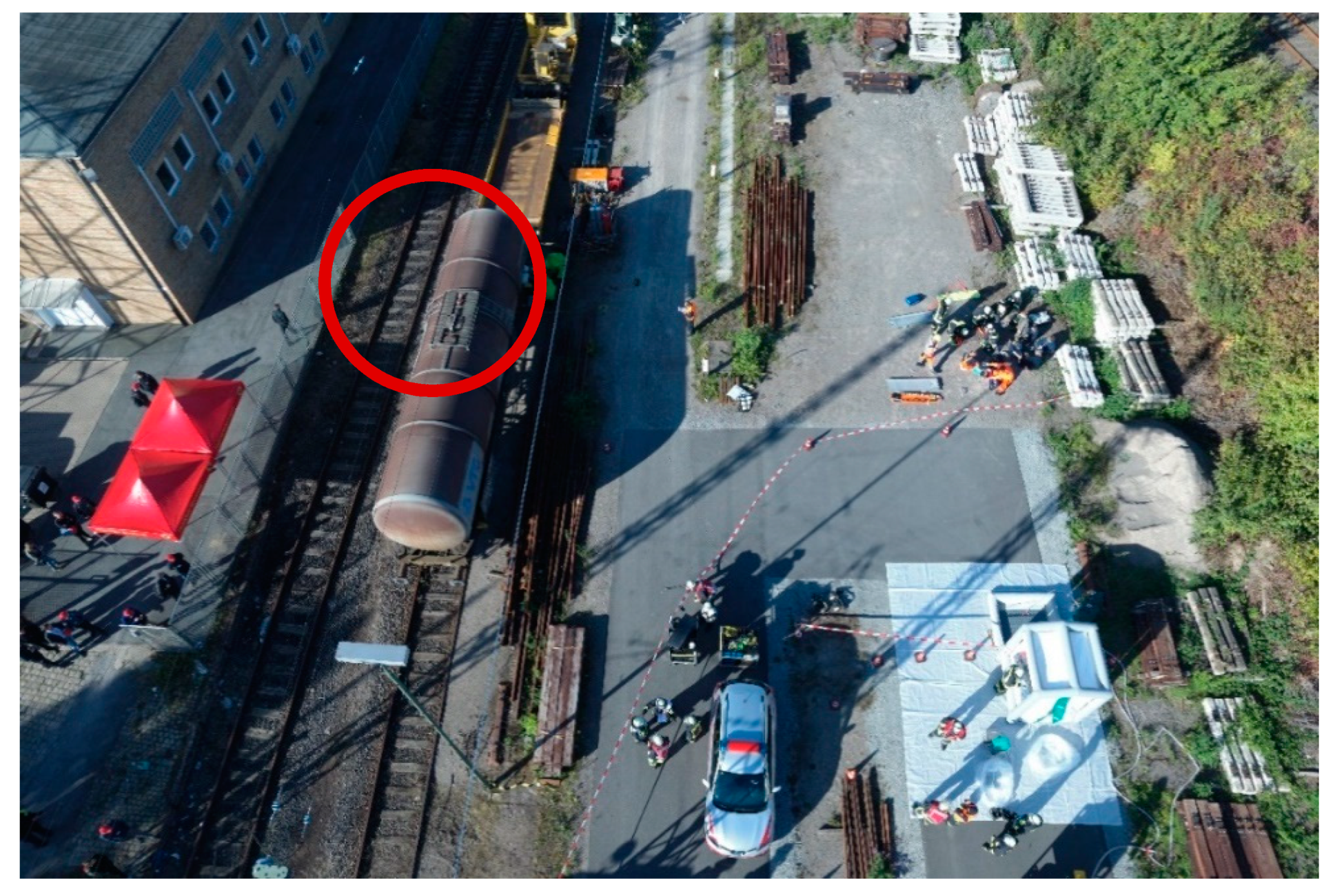
- to support preventive actions—during airborne inspections of hazardous materials transport and monitoring industrial facilities or installations,
- (2)
- responding to accidents involving hazardous substances—reconnaissance in the event of an accidental leakage of hazardous substances.
5. Conclusions
Funding
Conflicts of Interest
References
- Yinka-Banjo, C.O.; Ajayi, O. Sky-Farmers: Applications of Unmanned Aerial Vehicles (UAV) in Agriculture. Intech 2019, 107–128. [Google Scholar] [CrossRef] [Green Version]
- Berie, H.T.; Burud, I. Application of unmanned aerial vehicles in earth resources monitoring: Focus on evaluating potentials for forest monitoring in Ethiopia. Eur. J. Remote Sens. 2018, 51, 326–335. [Google Scholar] [CrossRef] [Green Version]
- Otto, A.; Agatz, N.; Campbell, J.; Golden, B.; Pesch, E. Optimization approaches for civil applications of unmanned aerial vehicles (UAVs) or aerial drones: A survey. Networks 2018, 1–48. [Google Scholar] [CrossRef]
- Melesse, A.; Weng, Q.; Prasad, S.; Senay, G. Remote Sensing Sensors and Applications in Environmental Resources Mapping and Modelling. Sensors 2007, 7, 3209–3241. [Google Scholar] [CrossRef] [PubMed] [Green Version]
- Drones. Reporting for Work. Available online: https://www.goldmansachs.com/insights/technology-driving-innovation/drones/ (accessed on 6 December 2020).
- Watson, J. Agriculture Drone Market 2020 CAGR of 22.6% forecasted for Excellent Revenue Growth USD 6.52 Billion by 2027|Reports and Data. Available online: https://apnews.com/dd8a288a73b2a3d2cfbb8ccd3d045f6b (accessed on 9 September 2020).
- Available online: https://www.globenewswire.com/news-release/2020/05/29/2041044/0/en/Small-Drones-Market-Size-to-Reach-USD-22-55-Billion-by-2026-Increasing-Deployment-of-UAVs-for-Surveillance-Purposes-to-Favor-Market-Growth-Says-Fortune-Business-Insights.html (accessed on 9 September 2020).
- Castellano, F. Commercial Drones Are Revolutionizing Business Operations. Available online: https://www.toptal.com/finance/market-research-analysts/drone-market (accessed on 6 December 2020).
- Available online: https://www.thefirstnews.com/article/drone-market-facing-staggering-3-billion-pln-boom-4579 (accessed on 9 September 2020).
- Available online: https://polandin.com/41179370/pl-drone-market-to-be-worth-eur-760-mln-in-10-years-dep-min. (accessed on 9 September 2020).
- Kim, D.-W.; Min, T.-S.; Kim, Y.; Silva, R.R.; Hyun, H.-N.; Kim, J.-S.; Kim, K.-H.; Kim, H.-J.; Chung, Y.S. Sustainable Agriculture by Increasing Nitrogen Fertilizer Efficiency Using Low-Resolution Camera Mounted on Unmanned Aerial Vehicles. Int. J. Environ. Res. Public Health 2019, 16, 3893. [Google Scholar] [CrossRef] [PubMed] [Green Version]
- Yang, F.; Shao, Q.; Jiang, Z. A Population Census of Large Herbivores Based on UAV and Its Effects on Grazing Pressure in the Yellow-River-Source National Park, China. Int. J. Environ. Res. Public Health 2019, 16, 4402. [Google Scholar] [CrossRef] [Green Version]
- Giordan, D.; Adams, M.S.; Aicardi, I.; Alicandro, M.; Allasia, P.; Baldo, M.; De Berardinis, P.; Dominici, D.; Godone, D.; Hobbs, P.; et al. The use of unmanned aerial vehicles (UAVs) for engineering geology applications. Bull. Eng. Geol. Environ. 2020, 79, 3437–3481. [Google Scholar] [CrossRef] [Green Version]
- Slezak, D.; Tyranska-Fobke, A.; Robakowska, M.; Nowak, J.; Zuratynski, P.; Ladny, J.R.; Kraszewski, J.; Domanska-Sadynica, M.; Nadolny, K. The use of drones in various rescue sectors—An analysis of examples in Poland and in the world. Post N Med. 2018, XXXI, 173–178. [Google Scholar] [CrossRef]
- Li, S.; Xiang, Q.; Ma, Y.; Gu, X.; Li, H. Crash Risk Prediction Modeling Based on the Traffic Conflict Technique and a Microscopic Simulation for Freeway Interchange Merging Areas. Int. J. Environ. Res. Public Health 2016, 13, 1157. [Google Scholar] [CrossRef] [Green Version]
- Hassanalian, M.; Abdelkefi, A. Classifications, applications, and design challenges of drones: A review. Prog. Aerosp. Sci. 2017, 92, 99–131. [Google Scholar] [CrossRef]
- Hoesly, R.M.; Smith, S.J.; Feng, L.; Klimont, Z.; Janssens-Maenhout, G.; Pitkanen, T.; Seibert, J.J.; Vu, L.; Andres, R.J.; Bolt, R.M.; et al. Historical (1750–2014) anthropogenic emissions of reactive gases and aerosols from the Community Emission Data System (CEDS). Geosci. Model Dev. 2018, 11, 369–408. [Google Scholar] [CrossRef] [Green Version]
- Yao, Y.; Wei, S.; Zhang, H.; Li, Q. Application of UAV in Monitoring Chemical Pollutant Gases. Chem. Eng. Trans. 2018, 67, 583–588. [Google Scholar] [CrossRef]
- Beloev, I.H. A Review on Current and Emerging Application Possibilities for Unmanned Aerial Vehicles. Acta Technol. Agric. 2016, 3, 70–76. [Google Scholar] [CrossRef] [Green Version]
- Alvear, O.; Zema, N.R.; Natalizio, E.; Calafate, C.T. Using UAV-Based Systems to Monitor Air Pollution in Areas with Poor Accessibility. J. Adv. Transp. 2017, 2017, 1–14. [Google Scholar] [CrossRef] [Green Version]
- Wespes, C.; Emmons, L.; Edwards, D.P.; Hannigan, J.; Hurtmans, D.; Saunois, M.; Coheur, P.F.; Clerbaux, C.; Coffey, M.T.; Batchelor, R.L.; et al. Analysis of ozone and nitric acid in spring and summer Arctic pollution using aircraft, ground-based, satellite observations and MOZART-4 model: Source attribution and partitioning. Atmos. Chem. Phys. 2012, 12, 237–259. [Google Scholar] [CrossRef] [Green Version]
- Gallachera, D. Drones to manage the urban environment. Risks, rewards, alternatives. J. Unmanned Vehicle Syst. 2016, 4, 115–124. [Google Scholar] [CrossRef] [Green Version]
- Villa, T.F.; Gonzalez, F.; Miljievic, B.; Ristovski, D.; Morawska, L. An Overview of Small Unmanned Aerial Vehicles for Air Quality Measurements: Present Applications and Future Prospectives. Sensors 2016, 16, 1072. [Google Scholar] [CrossRef] [Green Version]
- Gaffey, C.; Bhardwaj, A. Applications of Unmanned Aerial Vehicles in Cryosphere: Latest Advances and Prospects. Remote Sens. 2016, 12, 948. [Google Scholar] [CrossRef] [Green Version]
- Controlling an Autonomous Drone Using Goggles (Monocular), No. DOB-BIO9/26/04/2018; Project financed by the National Centre for Research and Development: Warszawa, Poland.
- Whitehead, K.; Hugenholtz, C.H.; Myshak, S.; Brown, O.; LeClair, A.; Tamminga, A.; Barchyn, T.E.; Moorman, B.; Eaton, B. Remote sensing of the environment with small unmanned aircraft systems (UASs), part 2: Scientific and commercial applications. J. Unmanned Veh. Syst. 2014, 2, 86–102. [Google Scholar] [CrossRef] [Green Version]
- López, J.J.; Mulero-Pázmány, M. Drones for Conservation in Protected Areas: Present and Future. Drones 2019, 3, 10. [Google Scholar] [CrossRef] [Green Version]
- Available online: https://www.pansa.pl/en/polish-air-navigation-services-agency-launched-the-first-operational-drone-flight-coordination-system-in-europe/ (accessed on 9 September 2020).
- Available online: https://www.orlen.pl/EN/PressOffice/Pages/Modern-technologies-improve-the-security-of-ORLEN%E2%80%99s-Production-Plant-in-P%C5%82ock.aspx (accessed on 9 September 2020).
- Sharma, M. How Drones Are Being Used to Combat COVID-19. 2020. Available online: https://www.geospatialworld.net/blogs/how-drones-are-being-used-to-combat-covid-19/ (accessed on 9 September 2020).
- European Union. Air Quality–Existing Legislation. Available online: https://ec.europa.eu/environment/air/quality/existing_leg.htm (accessed on 28 July 2020).
- Joint Report on Air Quality. EUROSAI Working Group on Environmental Auditing; The Netherlands Court of Audit and the Supreme Audit Office of Poland: Warszawa, Poland, 2019. [Google Scholar]
- Ncube, M.; Riffat, S. Developing an indoor environment quality tool for assessment of mechanically ventilated office buildings in the UK–A preliminary study. Build. Environ. 2012, 53, 26–33. [Google Scholar] [CrossRef] [Green Version]
- Heinzerling, D.; Schiavon, S.; Webster, T.; Arens, E. Indoor environmental quality assessment models: A literature review and a proposed weighting and classification scheme. Build. Environ. 2013, 70, 210–222. [Google Scholar] [CrossRef] [Green Version]
- Mihai, T.; Iordache, V. Determining the indoor environment quality for an educational building. Energy Procedia 2016, 85, 566–574. [Google Scholar] [CrossRef] [Green Version]
- McWilliams, J. Review of Airflow Measurement Techniques Lawrence Berkeley National Laboratory 2002-12-01. Available online: https://escholarship.org/uc/item/7532b84f (accessed on 27 May 2020).
- Weitkamp, C. (Ed.) Lidar Range-Resolved Optical Remote Sensing of the Atmosphere; Springer Science+Business Media Inc.: Berlin/Heidelberg, Germany, 2005. [Google Scholar]
- Nishizawa, T.; Sugimoto, N.; Matsui, I.; Shimizu, A.; Tatarov, B.; Okamoto, H. Algorithm to Retrieve Aerosol Optical Properties from High-Spectral-Resolution Lidar and Polarization Mie-Scattering Lidar Measurements. IEEE Trans. Geosci. Remote Sens. 2008, 46, 4094–4103. [Google Scholar] [CrossRef]
- Amiridis, V.; Balis, D.S.; Giannakaki, E.; Stohl, A.; Kazadzis, S.; Koukouli, M.E.; Zanis, P. Optical characteristics of biomass burning aerosols overSoutheastern Europe determined from UV-Raman lidarmeasurements. Atmos. Chem. Phys. 2009, 9, 2431–2440. [Google Scholar] [CrossRef] [Green Version]
- Koch, G.J.; Barnes, B.W.; Petros, M.; Beyon, J.Y.; Amzajerdian, F.; Yu, J.; Davis, R.E.; Ismail, S.; Vay, S.; Kavaya, M.J.; et al. Coherent differential absorption lidar measurements of CO2. Appl. Opt. 2004, 43, 5092–5099. [Google Scholar] [CrossRef]
- Collier, C.G.; Davies, F.; Bozier, K.E.; Holt, A.R.; Middleton, D.R.; Pearson, G.N.; Siemen, S.; Willetts, D.V.; Upton, G.J.G.; Young, R.I. Dual-Doppler Lidar Measurements for Improving Dispersion Models. Bull. Amer. Meteor. Soc. 2005, 86, 825–838. [Google Scholar] [CrossRef]
- Arnold, K.S.; She, C.Y. Metal Fluorescence lidar (light detection and ranging) and the middle atmosphere. Contemp. Phys. 2003, 44, 35–49. [Google Scholar] [CrossRef]
- Gaudio, P.; Gelfusa, M.; Malizia, A.; Parracino, S.; Richetta, M.; De Leo, L.; Perrimezzi, C.; Bellecci, C. Detection and monitoring of pollutant sources with Lidar/Dial techniques. J. Phys. Conf. Ser. 2015, 658, 1–9. [Google Scholar] [CrossRef]
- Mcdermott, H.J. Air Monitoring for Toxic Exposures; Wiley Interscience: Hoboken, NJ, USA, 2004; ISBN 0-471-45435-4. [Google Scholar]
- Knake, R.; Hauser, P.C. Sensitive electrochemical detection of ozone. Anal. Chim. Acta 2002, 459, 199–207. [Google Scholar] [CrossRef]
- Roldán, J.J.; Joossen, G.; Sanz, D.; del Cerro, J.; Barrientos, A. Mini-UAV based sensory system for measuring environmental variables in greenhouses. Sensors 2015, 15, 3334–3350. [Google Scholar] [CrossRef] [PubMed] [Green Version]
- Giurgiutiu, V. Structural Health Monitoring with Piezoelectric Wafer Active Sensors. In Proceedings of the 16th International Conference of Adaptive Structures and Technologies ICAST-2005, Paris, France, 10–12 October 2005. [Google Scholar]
- Bársony, I.; Dücső, C.; Fürjes, P. Thermometric Gas Sensing. In Solid State Gas Sensing; Comini, E., Faglial, G., Sberveglieri, G., Eds.; Springer Science+Bisoness Media, LLC: Boston, MA, USA, 2009; ISBN 978-0-387-09664-3. [Google Scholar]
- Hofman, J.; Maher, B.A.; Muxworthy, A.R.; Wuyts, K.; Castanheiro, A.; Samson, R. Biomagnetic monitoring of atmospheric pollution: A review of magnetic signatures from biological sensors. Environ. Sci. Technol. 2017, 51, 6648–6664. [Google Scholar] [CrossRef] [PubMed] [Green Version]
- Rutkauskas, M.; Asenov, M.; Ramamoorthy, S.; Reid, D.T. Autonomous multi-species environmental gas sensing using drone-based Fourier-transform infrared spectroscopy. Opt. Express 2019, 27, 9578–9587. [Google Scholar] [CrossRef] [PubMed]
- Rossi, M.; Brunelli, D. Autonomous Gas Detection and Mapping with Unmanned Aerial Vehicles. IEEE Trans. Instrum. Meas. 2015, 65, 765–775. [Google Scholar] [CrossRef]
- Kas, K.A.; Johnson, G.K. Using unmanned aerial vehicles and robotics in hazardous locations safely. Proc. Safety Prog. 2020, 39, e12066. [Google Scholar] [CrossRef]
- Available online: https://drones4safety.eu/ (accessed on 9 September 2020).
- Available online: http://labyrinth2020.eu/ (accessed on 9 September 2020).
- Available online: https://wzl2.mil.pl/en/about-us/eu-grants-projects/#1528886676139-2f7a66a1-9277 (accessed on 9 September 2020).
- ISO 21384-3:2019 Unmanned Aircraft Systems—Part 3: Operational Procedures; Reference Number ISO 21384-3:2019(E); CP 401. Ch. de Blandonnet 8. CH-1214; ISO Copyright Office: Vernier, Geneva, 2019; p. 18.
- ISO 21384-4:2020 Unmanned Aircraft Systems–Part 4: Vocabulary; Reference Number ISO 21384-4:2020(E); CP 401. Ch. de Blandonnet 8. CH-1214; ISO Copyright Office: Vernier, Geneva, 2020; p. 10.
- ISO 21895: 2020 Categorization and Classification of Civil Unmanned Aircraft Systems; Reference Number ISO 21895-2020(E); CP 401. Ch. de Blandonnet 8. CH-1214; ISO Copyright Office: Vernier, Geneva, 2020; p. 7.
- ISO/TR 23629-1: 2020 UAS Traffic Management (UTM)–Part 1: Survey Results on UTM; Reference Number ISO/TR 23629-1:2020(E); CP 401. Ch. de Blandonnet 8. CH-1214; ISO Copyright Office: Vernier, Geneva, 2020; p. 15.
- Standardization Roadmap for Unmanned Aircraft Systems—Working Draft, Version 2.0, Unmanned Aircraft Systems Standardization Collaborative (UASSC), UASSC 20-001; American National Standards Institute (ANSI): Washington, DC, USA, 2020; p. 356.
- Reneke, P.; Grant, C.; Bryner, N.P.; Jones, A.W.; Koepke, G.H. Research Roadmap for Smart Fire Fighting; National Institute of Standards and Technology (NIST): Gaithersburg, MD, USA, 2015. [Google Scholar] [CrossRef]
- Available online: https://www.flir.com/products/muve-c360/ (accessed on 7 December 2020).
- Available online: https://scentroid.com/products/analyzers/dr1000-flying-lab/ (accessed on 7 December 2020).
- Available online: https://aeromind.pl/product-eng-11475-Atmon-FL-Air-pollution-analyser.html (accessed on 7 December 2020).
- Available online: https://www.flir.com/products/zenmuse-xt2/ (accessed on 29 June 2020).
- Available online: https://www.gemsys.ca/uav-systems/ (accessed on 29 June 2020).
- Available online: https://www.gemsys.ca/uav-platforms/ (accessed on 29 June 2020).
- Available online: https://www.maxbotix.com/ultrasonic-sensor-operation-uav.htm (accessed on 29 June 2020).
- Available online: https://micasense.com/rededge-mx/ (accessed on 29 June 2020).
- Available online: https://www.flycamuav.com/product/dronerad-detector-systems/ (accessed on 29 June 2020).
- Available online: https://www.sensichips.com/smart-cable-air/ (accessed on 29 June 2020).
- Available online: https://cordis.europa.eu/project/id/674434/reporting (accessed on 29 June 2020).
- European Commission. Directive 2014/34/EU of the European Parliament and of the Council of 26 February 2014 on the Harmonisation of the Laws of the Member States Relating to Equipment and Protective Systems Intended for use in Potentially Explosive Atmospheres; European Commission: Brussels, Belgium, 2014; pp. 309–356. [Google Scholar]
- Aiello, G.; Hopps, F.; Santisi, D.; Venticinque, M. The Employment of Unmanned Aerial Vehicles for Analyzing and Mitigating Disaster Risks in Industrial Sites. IEEE 2020, 67, 519–530. [Google Scholar] [CrossRef]
- Ferlin, M.; Kurela, M.; Monge, O.; Castgnet, C. Smart Operations in ATEX RLV Environment. In Proceedings of the 8th European Conference for Aeronautics and Space Sciences (EUCASS), Madrid, Spain, 1–4 July 2019; pp. 1–13. [Google Scholar] [CrossRef]
- Available online: http://www.hazardexonthenet.net/article/121803/Drone-operations-in-hazardous-areas.aspx (accessed on 26 September 2020).
- European Commission. ANNEX I–CLASSIFICATION OF PLACES WHERE EXPLOSIVE ATMOSPHERES MAY OCCUR, Directive 1999/92/EC of the European Parliament and of the Council of 16 December 1999 on Minimum Requirements for Improving the Safety and Health Protection of Workers Potentially at Risk from Explosive Atmospheres; European Commission: Brussels, Belgium, 2020. [Google Scholar]
- GAZ SYSTEM. Sustainable Development Report. 2018. Available online: https://en.gaz-system.pl/fileadmin/centrum_prasowe/wydawnictwa/EN/AnnualRaport2018_www.pdf (accessed on 28 July 2020).
- Available online: http://www.hazardexonthenet.net/article/65112/Poland-gas-pipeline-explosion-kills-3--injures-10.aspx (accessed on 28 July 2020).
- Restas, A. Drone applications for preventing and responding HAZMAT disaster. World J. Eng. Technol. 2016, 4, 76–84. [Google Scholar] [CrossRef] [Green Version]
- Auburn, L.; Researchers Using Drones to Detect Noxious Gas Released by Explosions. Rochester Institute of Technology/News. 2020. Available online: https://www.rit.edu/news/researchers-using-drones-detect-noxious-gas-released-explosions (accessed on 28 July 2020).
- Everts, S.; Davenport, M. Drones detect threats such as chemical weapons, volcanic eruptions. CEN Glob. Enterp. 2016, 94, 36–37. [Google Scholar] [CrossRef]
- Available online: https://pelixar.com/unmanned-systems/?lang=en (accessed on 6 December 2020).
- Marturano, F.; Ciparisse, J.-F.; Chierici, A.; d’Errico, F.; Di Giovanni, D.; Fumian, F.; Rossi, R.; Martellucci, L.; Gaudio, P.; Malizia, A. Enhancing Radiation Detection by Drones through Numerical Fluid Dynamics Simulations. Sensors 2020, 20, 1770. [Google Scholar] [CrossRef] [Green Version]
- Drones in Humanitarian Action. Case Study No.11: Natural disaster/Acute emergency/Search and Rescue. Simulation–Drones for Search and Rescue in Emergency Response Simulation. Available online: https://reliefweb.int/sites/reliefweb.int/files/resources/Drones%20in%20Humanitarian%20Action%20-%20Case%20Study%2011%20-%20Search%20and%20Rescue%20Trimodex.pdf (accessed on 9 September 2020).
- eNOTICE Newsletter 2. 22 January 2020. Available online: https://cloud.h2020-enotice.eu/index.php/s/newsletter2#pdfviewer (accessed on 9 September 2020).
- Kinaneva, D.; Hristov, G.; Raychev, J.; Zahariev, P. Early Forest Fire Detection Using Drones and Artificial Intelligence. Computer Science. In Proceedings of the 42nd International Convention on Information and Communication Technology, Electronics and Microelectronics (MIPRO), Rijeka, Croatia, 20–24 May 2019. [Google Scholar] [CrossRef]
- Available online: https://www.geoscan.aero/en/products/choose_uav (accessed on 9 September 2020).
- Shakhatreh, H.; Sawalmeh, A.; Al-Fuqaha, A.; Dou, Z.; Almaita, E.; Khalil, I.; Othman, N.S.; Khreishah, A.; Guizan, M. Unmanned Aerial Vehicles: A Survey on Civil Applications and Key Research Challenges. Available online: https://arxiv.org/pdf/1805.00881.pdf (accessed on 9 September 2020).
- Pepe, M.; Fregonese, L.; Scaioni, M. Planning airborne photogrammetry and remote-sensing missions with modern platforms and sensors. Eur. J. Remote. Sens. 2018, 51, 412–436. [Google Scholar] [CrossRef]
- Marques, M.M.; Carapau, R.S.; Rodrigues, A.V.; Lobo, V.; Gouveia-Carvalho, J.; Antunes, W.; Gonçalves, T.; Duarte, F.; Verissimo, B. GammaEx project: A solution for CBRN remote sensing using unmanned aerial vehicles in maritime environments. In Proceedings of the OCEANS 2017, Anchorage, AK, USA, 18–21 September 2017. [Google Scholar]
- Fumian, F.; Di Giovanni, D.; Martellucci, L.; Rossi, R.; Gaudio, P. Application of Miniaturized Sensors to Unmanned Aerial Systems, A New Pathway for the Survey of Polluted Areas: Preliminary Results. Atmosphere 2020, 11, 471. [Google Scholar] [CrossRef]


| Lidar Type | Detection Technique | Application Range | Ref |
|---|---|---|---|
| Scattering | Radiation—a laser emitting a single wave of a specific length (one channel); detector—records the feedback signal (scattering) from the tested object in the atmosphere | Temperature; measurements; boundary layer height; presence and location of dust and aerosols in the atmosphere | [38] |
| Raman | Uses the phenomenon of wavelength shift (different for different molecules) of scattered radiation on the object’s molecules (gas, aerosols, dust) caused by inelastic energy exchange between the molecule and the returning photon (Raman scattering) | Water vapor; ozone; atmospheric temperature profiles; climate and weather research | [39] |
| Differential absorption | Two wavelengths are transmitted: the first wavelength is inverted to the adsorption line of the test object (s), the second wavelength is slightly further from the first and is slightly adsorbed by the object; the concentration of chemicals in the atmosphere can be determined from the differential absorption coefficient between the two wavelengths | Water vapor; nitrogen oxides; sulphur oxides ozone; methane; ammonia; temperature measurements | [40] |
| Doppler | Uses the measurement of the Doppler shift frequency of laser radiation scattered by moving aerosol or dust particles at wind speed; requires lasers with a very narrow and stable line | Wind speed measurement | [41] |
| Fluorescent | The device emits laser pulses of wavelength (in the range of visible and ultraviolet light) with that absorbed by the determined substances; the radiation emitted by the substance is focused by the telescope and directed towards it; detector | Metal atoms (Na, K, Ca, Li, Fe) and ions (Ca) | [42] |
| Sensors | Parameters | Application | Advantage | Disadvantage | Ref |
|---|---|---|---|---|---|
| Infrared sensors | |||||
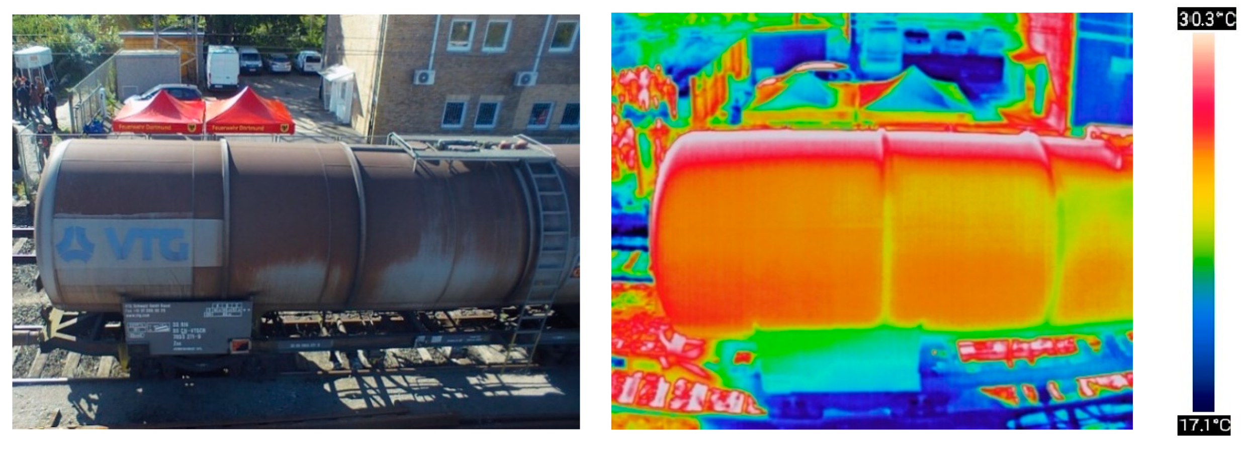
| Zenmuse XT2 | Resolution: 640 × 512 or 336 × 256 Frequency: 30 Hz IP: 44 Mass: 629 g Temperature detection range: −40–550 °C | Fire Solar panel inspections Research relating to hazardous materials power industry Agriculture Building inspections Rescue | Numerous additional functions: Temperature alarm Tracking of the warmest object Overlay an RGB over thermal image Freezing the view on a specific object View of a specific temperature spectrum band | [65] | |
| Magnetometers | |||||
| The AirBIRD | Mass: 3.5 kg Minimum cruising speed: 10 m/s Operating time: 1.5 h GPS accuracy: 0.7 m Sensitivity: 0.022 nT Refreshing: 1 Hz Accuracy: ±0.1 nT Tolerance gradient: 50,000 nT/m | Measurements of the magnetic field and its changes | High measurement accuracy Measurements broadcast live by radio to the GCS | The test lead makes it difficult to use in the field with obstacles Difficult operations during high winds | [66] |
| The MONARCH | Plane with built-in two magnetic field sensors Sensitivity: 0.022 nT Refresh: 1 Hz Accuracy: ±0.1 nT Gradient Tolerance: 50,000 nT/m | Measurements of the magnetic field and its changes | No system cable required Possibility of flight in worse weather conditions The ability to fly with a small amount of terrain obstacles | Cannot hover | [67] |
| Sonars | |||||
| MB1242 | Interface: I2C Supply voltage: 3–5.5 V Frequency: 42 kHz Refresh rate: 10–40 Hz Weight: a few grams | Distance measurement Automatic flights | Low power consumption Low interference impact Easy to mount Low price | Reliability (certainty) of measurements Low range (up to several meters) | [68] |
| Multispectral sensors | |||||
| RedEdge-MX | Weight: 231.9 g Battery voltage: 4.2–15.8 V Power: 4 W peak 8 W Spectral bands: Blue, green, red IR Frequency: 1 Hz Interfaces: Serial, Ethernet, removable Wi-Fi, GPS, SDHC | Measurements of different objects in different light ranges can give information on: Substrate moisture Condition/condition of plants Temperature | Broad range of application Relative low mass | High price | [69] |
| Radiation sensors | |||||
| DroneRad | Resolution: 1 µR/HR Interface: RS-232, USB (optional) IP: 64 GPS measurement location | Measurement of gamma radiation and X-rays (optional number of neutrons) | Easy to install Wireless Detection of the type of radioactive substance Battery powered | [70] | |
| Toxic substances sensors | |||||
| Smart Cable Air | Battery power: 1.5–3.6 V Power: 2 mW Interface: I2C or SENSIBUS Substances to be measured:
| Measurements of substances in quantities endangering human health | Low power consumption Additional measurement of humidity and temperature | Requires adaptation to the drone | [71,72] |
| MUVE C360 | Weight: 680 g Measured substances: CO, Cl2, O2, NO2, H2S, SO2, lower explosive limit IP: 43 Battery power: 24 V | Measurements of substances in quantities endangering human health | Results transmitted live | Requires the use of a specific UAV Power supply from UAV No thresholds or warnings | [62] |
Publisher’s Note: MDPI stays neutral with regard to jurisdictional claims in published maps and institutional affiliations. |
© 2020 by the authors. Licensee MDPI, Basel, Switzerland. This article is an open access article distributed under the terms and conditions of the Creative Commons Attribution (CC BY) license (http://creativecommons.org/licenses/by/4.0/).
Share and Cite
Rabajczyk, A.; Zboina, J.; Zielecka, M.; Fellner, R. Monitoring of Selected CBRN Threats in the Air in Industrial Areas with the Use of Unmanned Aerial Vehicles. Atmosphere 2020, 11, 1373. https://doi.org/10.3390/atmos11121373
Rabajczyk A, Zboina J, Zielecka M, Fellner R. Monitoring of Selected CBRN Threats in the Air in Industrial Areas with the Use of Unmanned Aerial Vehicles. Atmosphere. 2020; 11(12):1373. https://doi.org/10.3390/atmos11121373
Chicago/Turabian StyleRabajczyk, Anna, Jacek Zboina, Maria Zielecka, and Radosław Fellner. 2020. "Monitoring of Selected CBRN Threats in the Air in Industrial Areas with the Use of Unmanned Aerial Vehicles" Atmosphere 11, no. 12: 1373. https://doi.org/10.3390/atmos11121373
APA StyleRabajczyk, A., Zboina, J., Zielecka, M., & Fellner, R. (2020). Monitoring of Selected CBRN Threats in the Air in Industrial Areas with the Use of Unmanned Aerial Vehicles. Atmosphere, 11(12), 1373. https://doi.org/10.3390/atmos11121373