Article

An Update on the Status of Mean Sea Level Rise around the Korean Peninsula

1
Honorary Research Fellow, US Coastal Education and Research Foundation, Lawrence, KS 66044, USA
2
Principal Research Scientist, Marine Disaster Research Center, Korea Institute of Ocean Science and Technology, Busan 49111, Korea
*
Author to whom correspondence should be addressed.
Atmosphere 2020, 11(11), 1153; https://doi.org/10.3390/atmos11111153
Submission received: 27 September 2020 / Revised: 21 October 2020 / Accepted: 23 October 2020 / Published: 26 October 2020
(This article belongs to the Special Issue Meteorological Extremes in Korea: Prediction, Assessment, and Impact)

Abstract

:
The threat of sea level rise to the heavily populated Korean Peninsula, which contains around 15,000 km of coastline bordering open sea margins, has profound and far reaching implications. This study updates and extends previous detailed studies with the addition of a further 2 years of data to the end of 2019, providing renewed robustness to the identification of emerging threats associated with sea level rise within the warming sea margins around the Korean Peninsula. The study analyzes tide gauge records and satellite altimetry around the Republic of Korea using enhanced time series analysis techniques to detect coastal vertical land motion and current rates of rise in mean sea level to augment planning, design and risk management activities. Despite fluctuations over time at each site, the highest “relative” mean sea level at each of the seven longest tide gauge records occurs in 2019, with weak evidence of an acceleration in the increase in mean sea level around the Republic of Korea. Trends in sea surface height from satellite altimetry across this region note two discreet areas east and west of the Korean Peninsula around 37.5° N (around Ulleungdo Island and in the Gyeonggi Bay region of the Yellow Sea), where rates of rise are well above the global average trend.

1. Introduction

The Korean Peninsula landmass is approximately 100,000 km2, containing around 15,000 km of coastline bordering the open ocean sea margins of the East Sea (Sea of Japan), East China Sea and Yellow Sea. These sea margins include a vast archipelago of more than 3500 islands. The current economic prosperity enjoyed by Korea, having evolved from one of poorest countries in the world prior to 1960 to the world’s 11th largest economy in 2015 [1], relies in part on continuing to successfully manage physical coastal processes and, in particular, threats posed by typhoons to developed coastal margins and associated port infrastructures.
The additional threat posed by rising sea levels associated with climate change has loomed large over the course of the 21st century and beyond throughout the low elevation coastal zones around the world [2,3]. Depending on the rate of global greenhouse gas emissions this century, forecast modeling suggests that an associated rise in global mean sea level could be as high as 100 cm (or more), with an annual rate of rise possibly in the range of 10–20 mm by the year 2100 [4].
The prominence of the climate change issue has placed more emphasis on continued examination and monitoring of available long tide gauge records situated on coastlines along with more recent satellite altimetry data which provide sea surface height products of the open ocean domain from around 1992 onwards. The knowledge gleaned permits a better understanding of the sea level rise phenomena and enables earlier detection of key trends of significance at increasingly finer (regional and local) scales to assist with necessary policy development, planning and adaptation endeavors.
Difficulties arise however in attempting to understand sea level rise from tide gauge records. The reason is that water levels recorded at a tide gauge are a complex composite of a comparatively small, nonstationary, nonlinear mean sea level signal arising from the thermal expansion of the ocean water mass and melting of snow and ice reserves associated with a slowly changing climate, significant and substantial dynamic interdecadal (and other) influences, environmental noise and vertical land motions (VLM) occurring at the tide gauge. Understanding these influences and developing techniques to separate the influences of interest remain the key to improving our regional understanding of the climate change induced sea level rise phenomena from lengthening tide gauge records.
Watson [5] provides a synopsis of the range of studies undertaken investigating mean sea level trends and accelerations around the Republic of Korea [6,7,8,9,10,11,12]. Prior to 2016, these studies derived comparatively simple “relative” sea level trends exclusively using linear regression techniques. In doing so, derived trends were influenced by the shortness of the available records (see Section 4.1) as well as climate modes (in particular) and VLM. Another significant drawback of the linear analysis is that it provides no temporal instruction of how the rate of mean sea level might be changing over time. The results of Yoon [12], using linear analysis on 19 station records around the Korean Peninsula with a minimum length of 30 years, suggested that rates of relative sea level rise were relatively small along the western coast (average 2.0 mm/yr), large along the southern and eastern coasts (averages 2.8 and 3.6 mm/yr, respectively) and very large around Jeju Island (average 3.8 mm/yr).
Both Kim and Cho [10] and Watson [5] provided the initial attempts at analyzing mean sea level records around the Korean Peninsula using more sophisticated data adaptive time series techniques. Kim and Cho [10] analyzed the five longest records (Mokpo, Jeju, Busan, Ulsan and Mukho) through the application of ensemble empirical mode decomposition (EEMD) to define mean sea level and then central difference techniques to estimate the time-varying velocities and accelerations. This work appears to be the first attempt to consider acceleration for the Republic of Korea mean sea level records. Accelerations were also separately estimated using the quadratic coefficient of a polynomial regression fitted to the residual of the EEMD approach. Results suggested a rising trend of sea level rise at all five stations considered, with Jeju showing the highest trend (≈5 mm/yr). Trends were converted to a “geocentric” reference frame after correcting for Glacial Isostatic Adjustment (only).
The study of Watson [5] advanced the work of Kim and Cho [10] through the use of Singular Spectrum Analysis (SSA) techniques optimized specifically for mean sea level research to isolate the trend with time varying velocity and acceleration estimated from fitted cubic smoothing splines. This study provided the first national assessment of VLM around the Korean Peninsula for application in sea level analysis.
The current study continues the refinement and improvement in analysis techniques for sea level research by incorporating further advancements in time series analysis with improved assessment of VLM into an update of the previous work of Watson [5] with an expanded regional assessment of satellite altimetry trends in the sea margins fringing the Korean Peninsula. Knowledge of VLM is critical to understanding which portions of the coastline are subsiding and therefore exacerbating current and future threats associated with rising mean sea levels. VLM assessment has been enhanced for this study in line with more recent developments [13]. In general, the improved VLM assessment results in a reduction of the higher rates of subsidence and uplift from previous work.
The key objective of this paper is to extend the previous data analysis [5] by an additional 2 years to the end of 2019, incorporating recent advancements in both estimating VLM and isolating the mean sea level signal with improved temporal resolution. Other objectives of the revised paper are to provide renewed robustness to the identification of emerging threats within the warming sea margins around the Korean Peninsula whilst providing a blueprint for future reanalysis endeavors.
The paper is structured with a detailed explanation of the analytical methodologies applied and the data used (Section 2), leading into a presentation of the results of the updated analysis (Section 3), which are discussed in detail (Section 4), and finally, conclusions are provided (Section 5).

2. Materials and Methods

Differing methodologies have been applied in this study, dependent upon the specific analysis and the length of the respective datasets. The applied methodology can be appropriately partitioned into analysis of the historical tide gauge records, sea-surface heights from satellite altimetry and estimates of VLM. An extension software package titled “TrendSLR” [14] within the framework of the R Project for Statistical Computing [15] provides a range of diagnostic and analysis tools that have been used to facilitate aspects of the analysis undertaken for this paper and which are detailed further in the following sections. Other analysis and graphical outputs have been developed by the authors from customized scripting code within the framework of R [15].

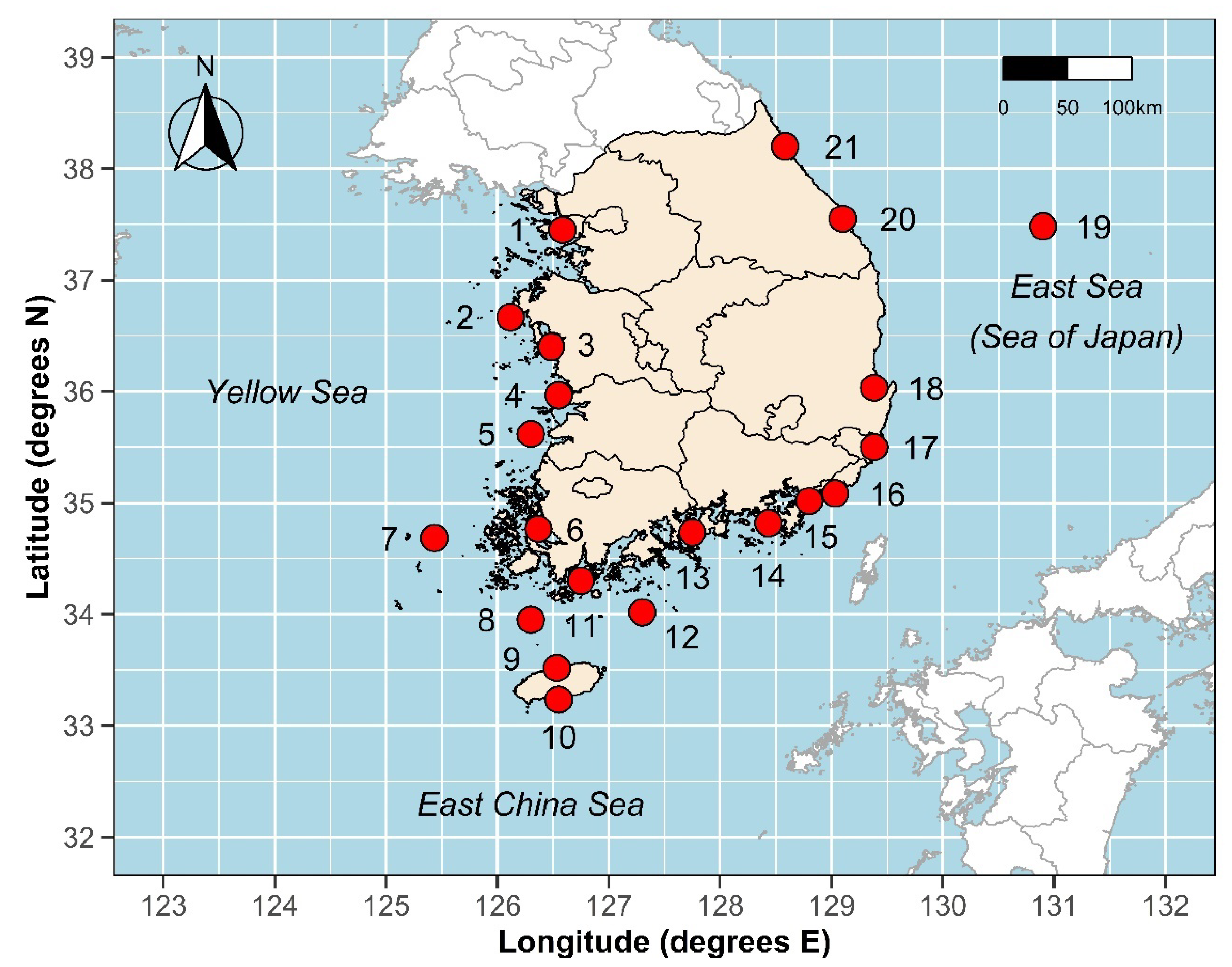
2.1. Data Sources Used in the Study

Only the Revised Local Reference (RLR) datum annual and monthly average time series from the public archives of the Permanent Service for Mean Sea Level (PSMSL) [16,17] have been used in the analysis, up to and including 2018. These data are provided to the PSMSL by the Korea Hydrographic and Oceanographic Agency (KHOA) [18]. Additional data to extend relevant time series to the end of 2019 have been sourced directly from the KHOA. The 21 sites analyzed represent the longest records available that, as a minimum, span the satellite altimetry era (post 1992). Each record has notionally been assigned a station ID commencing with Incheon (ID = 1) in the north-west, progressing anti-clockwise around the country to Sokcho (ID = 21) in the north-east, bordering the East Sea (Sea of Japan) (refer to Figure 1, Table 1).
Satellite altimeter products supplied by the European Commission’s Copernicus Marine Environment Monitoring Service (CMEMS) [19] have been used to extract time series of Sea Surface Height Anomalies (SSHA). The two-satellite merged global gridded L4 (008_057) product has been made available for this research in netCDF format with daily outputs spanning the period 1 January 1993 to 15 October 2019 on a spatial resolution grid of 0.25° × 0.25° (Cartesian). These data have been used to estimate VLM at each tide gauge site based on trends from differenced altimetry–tide gauge techniques (ALT-TG, refer to this section for further details).
Gridded SSHA trends for the period from September 1992 to May 2019 have been made available in netCDF for each of the sea margins around the Republic of Korea from multi-mission Ssalto/Duacs altimetry data from CMEMS, distributed by the Archiving, Validation and Interpretation of Satellite Oceanographic (AVISO) site [20]. Trends are based on simple linear regression analysis and provided on the same spatial resolution grid of 0.25° × 0.25° (Cartesian). These data have not been adjusted for Glacial Isostatic Adjustment (GIA). Associated error margins are not provided with the AVISO gridded trends.

2.2. Historical Tide Gauge Analysis

The general methodology applied in analyzing the observational tide gauge records has been well established in the recent literature and applied in detailed regional sea level studies around the USA, Europe, Korea and Australia [5,21,22,23]. SSA has been optimized specifically for mean sea level research [24] to efficiently decompose an annual time series to separate out components of slowly varying trends from oscillatory components with variable amplitude and components comprising largely structureless noise. Only the longest annual average records available from the PSMSL (>50 years in length) were considered for trend analysis (refer to Table 1 for details).

2.3. Step by Step Methodology

The methodology applied in analyzing the observational tide gauge records can be broadly summarized in the following six steps.
Step 1: Gap-filling of tide gauge records. This is a necessity for decomposing time series using SSA. Whilst the longest and most complete tide gauge records have been used for analysis, missing data persists in most long records. A range of gap-filling procedures available within the ‘TrendSLR’ package have been used to fill incomplete time series. Where there are gaps, records have been filled using an iterative SSA procedure [25] as the first preference, due to an (assumed) advantage in preserving the principal spectral structures of the complete portions of the original dataset in filling the gaps.
Step 2: Estimation of ‘relative’ mean sea level. Having necessarily filled the time series in Step 1, the record is decomposed using 1 dimensional SSA to isolate components of slowly varying trend (i.e., mean sea level due to external climate forcing) from oscillatory components with variable amplitude, and noise. From the SSA decomposition, ‘relative’ mean sea level is estimated by summation of ‘trend-like’ components. Thus, understanding the transition point between the trend (of primary interest) and low frequency natural oscillations becomes the key consideration. From the SSA decomposition, the components are ordered based on their contribution to the original time series, deeming that the first component, must constitute trend. With the use of long annual average mean sea level time series, the key issue is to identify any other components with ‘trend-like’ characteristics [23]. One method of quantitatively considering such characteristics is to apply a periodogram to each of the components from the SSA decomposition to inspect their spectral properties and apply techniques like frequency thresholding [26]. From an analysis of the literature, in particular the recent published works of Mann, Steinman, and Miller [27], it is considered prudent for mean sea level analysis that the difference between trend and oscillatory behavior resides around the ≈ 50 yr frequency band. Specifically, in the case of the analysis for this study, ‘trend’ has been considered to comprise components from an SSA decomposition of annual time series in which the substantive portion (>50%) of the relative spectral energy resides in the low frequency band (0–0.02 cycles per yr).
Step 3: Estimation of ‘relative’ mean sea level velocity and acceleration. This is estimated from the first derivative of a cubic smoothing spline fitted to the isolated ‘trend’ component(s) determined via Step 2. In each case, a fitted spline (with approximately 1 degree of freedom (DOF) every 8 years of record) results in the coefficient of determination (R2) of the fitted spline to the mean sea level ‘trend’ exceeding 0.99, providing a high degree of confidence in this form of model to estimate the associated time varying velocity at each time step. The advised default setting for the DOF of the fitted spline used in the ‘TrendSLR’ package is based on extensive sensitivity testing [24]. However, the package permits visual inspection of the fitted spline and fine tuning of the DOF if required.
Step 4: Estimation of standard errors associated with analysis of individual tide gauge records. This process initially involves fitting an autoregressive integrated moving average (ARIMA) time series model to remove the serial correlation in the differences (or residuals) between the SSA derived trend (Step 2) and the gap-filled time series (Step 1). This process is automated within the ‘TrendSLR’ package based on the stepwise algorithm approach developed by Hyndman and Khandakar [28]. The estimation of error in the ‘relative’ mean sea level (trend) and associated velocity and acceleration is then based on bootstrapping techniques where the uncorrelated residuals are randomly recycled, and the processes described in Steps 2 and 3 are repeated 10,000 times. From the extensive pool of outputted ‘relative’ mean sea level and associated velocities and accelerations, standard deviations are readily calculated to derive robust confidence intervals at each time step. Detailed summary reports of the analysis and results are captured by the ‘TrendSLR’ package for each station record.
Step 5: Estimation of VLM at tide gauge record. Following the approach advocated by Ostanciaux et al. [29] and further updated by Watson [13], VLM is estimated via an ALT-TG technique by applying a least squares linear regression fit to the difference between the monthly averages derived from satellite altimetry and the ‘relative’ tide gauge record at a point of interest. In addition, Watson [13] found that ALT-TG VLM estimates are substantially improved by using gridded altimetry SSHA products no closer than 30 km from the open coast and islands. This condition has also been applied in this study to the use of the SSHA products to optimize the accuracy of VLM estimates. Monthly average tide gauge data from the PSMSL were used in the analysis, spanning the period from January 1993 to December 2018. Satellite altimeter products supplied by (CMEMS) [19] have been used to extract time series of SSHA. Daily SSHA data have been converted into monthly average time series to align with the tide gauge data for ALT-TG analysis. The ALT-TG VLM estimates using a linear least squares fitted model automatically provide an associated standard error. As an additional sensitivity check, the selected grid point was checked against other adjoining gridded trends to ensure that the data were not anomalous within the surrounding sea margin of interest.
Step 6: Correction of “relative” mean sea level velocity to “geocentric” reference frame for each tide gauge record. The “relative” velocity at each year (Step 3) is added to the VLM (Step 5) to estimate time varying velocity in a “geocentric” reference frame over the course of each record. The standard error in the “geocentric” velocity is determined simply in quadrature from the standard error in the “relative” velocity each year (Step 4) with the standard error in the VLM estimate (Step 5).

3. Results

All analysis results are presented with error margins at the 95% confidence level, unless noted otherwise. Figure 2 summarizes results of the decomposition of the seven (7) tide gauge records exceeding 50 years in length to provide a best estimate of the time varying “relative” mean sea level and associated velocity and acceleration over time. It is evident that mean sea level has risen at each location through to the present over the available timeframe (post 1960). Despite fluctuations over time at each site, the highest “relative” mean sea level occurs in 2019 at each record.
It is evident from these analyses that the “relative” velocity has varied markedly, but, at most locations, there has been a tendency for velocity to generally increase over time, suggesting the presence of an acceleration. In 2019, the “relative” velocity varies across these sites from a low of 1.3 mm/yr (Yeosu) to 4.9 mm/yr (Jeju), with key differences predominantly associated with vertical land motions (refer to top panel, Figure 3).
The results of the vertical land motion analysis at each of the 21 tide gauge locations spanning the satellite altimetry era (post 1992) are graphically displayed in the second panel of Figure 3 and in tabular format in Table 2. In general, the results are quite varied around the country, with some five locations exhibiting rates of uplift exceeding 1 mm/yr (Incheon, Anheung, Wido, Heuksando and Yeosu) and six sites where rates of subsidence exceed 1 mm/yr (Gunsan, Mokpo, Jeju, Geomundo, Gadeokdo and Pohang). The largest rate of subsidence observed was at the Pohang tide gauge station, which has been separately identified as subject to high subsidence using different measuring techniques (Persistent Scatter Interferometric Synthetic Aperture Radar or PS-InSAR) [30]. Areas in which subsidence is prevalent present a heightened threat from sea level rise. In general, larger rates of uplift were observed along the coastal margins bounded by the Yellow Sea, whilst higher rates of subsidence were typically observed around the margins bounded by the East China Sea and East Sea (Sea of Japan). Improvements to the ALT-TG technique [13] have resulted in the range of VLM estimates reducing from between +3.7 and −7.4 mm/yr [5] to between +3.2 and −4.8 mm/yr for this study (refer to Discussion section).
The third panel of Figure 3 provides a summary of the estimated “geocentric” velocity in 2019 for each of the records longer than 50 years, following corrections for VLM. The “geocentric” estimates in 2019 are also provided in tabular format in Table 2. With the exclusion of Mokpo, the “geocentric” velocities around the Republic of Korea in 2019 range between 2.6 ± 1.6 (Mukho) and 4.1 ± 2.1 mm/yr (Incheon). These “geocentric” velocities are in close agreement with the associated SSHA trends from the satellite altimetry (Table 2), noting that the SSHA trends are derived from a much smaller dataset and the linear regression applied does not take account of the dynamic influences embedded within the dataset. The anomaly evident in the “geocentric” velocity at Mokpo in 2019 (−0.6 ± 4.5) is likely the combination of several factors. Firstly, there are some years of missing data at the recent end of the time series, which increases error margins and uncertainty over SSA decomposition to estimate mean sea level. Secondly, the ALT-TG VLM at this location is more difficult to estimate because of the extent of the archipelago of small islands in the vicinity of Mokpo which increases the distance to satellite altimetry measurements which are likely to be less contaminated by geophysical corrections (refer to Discussion section).
Trends in SSHA observed from AVISO satellite altimetry data [20] over the period from September 1992 to May 2019 show some key spatial signatures within the sea margins surrounding the Republic of Korea (refer to Figure 4). The average SSHA trend within the sea margins depicted in Figure 4 is 3.5 mm/yr, varying between a low of 0.2 mm/yr within the Seto Inland Sea margin (131.875° E, 33.875° N) and a peak of 7.6 mm/yr (130.625° E, 37.375° N) within the East Sea (Sea of Japan).
There are two distinct regions of SSHA trends around the Republic of Korea which are above the global average trend of 3.7 ± 0.4 mm/yr (without GIA correction) [30]. These regions are located to the east and west of the country at around 37.5° N. The region in the East Sea (Sea of Japan) is centered close to Ulleungdo Island, covering an area larger than 44,000 km2 within which the SSHA trend is above 4 mm/yr. Within this margin, an area exceeding 7000 km2 exhibits SSHA trends exceeding 6 mm/yr. To the west of Seoul in the Gyeonggi Bay region of the Yellow Sea, a peak of 5.6 mm/yr (126.125° E, 37.625° N) is evident. This peak sits within an area encompassing 13,000 km2, in close proximity to the coast within, which the SSHA trend is similarly above 4 mm/yr.
It should be clearly emphasized here that these are linear trends in sea surface height over the ≈26.5 year altimetry period that will be significantly influenced by internal climate modes (such as ENSO, etc.) on such timescales. These SSHA trends are therefore not directly comparable to ‘relative’ and ‘geocentric’ velocities determined from the longer tide gauge records analyzed in this study, which firstly remove such influences from the record and secondly, estimate time varying velocities in real-time, rather than averages across the record length.

4. Discussion

Whilst employing state-of-the-art analytical techniques for mean sea level research, this study gives rise to various discussion points, highlighted in the following sections.

4.1. General Limitations of Study

One of the key limitations of the study is that the maximum length datasets available for analysis around the Korean Peninsula are only 59 years (1960 to 2019 at Incheon, Mokpo and Busan), somewhat short of the optimal minimum lengths suggested for mean sea level analysis. In particular, minimum length datasets are recommended in the order of 75–80 years to ensure that the trend signal (or in this case, mean sea level) is optimally separable from the contaminating dynamic cyclical signals and noise [24,31].
The results of the analysis presented in this study represent an attempt to maximize the information that can be gleaned from the available records, recognizing the constraints on record lengths specific to the Republic of Korea. Notwithstanding, the analysis techniques employed identify the lowest frequency signal (or trend) permitted by the length of the datasets available.
This study uses the ALT-TG technique as a proven, consistent and reliable proxy for VLM [13] in the absence of continuous Global Navigation Satellite System stations either being located close to tide gauge stations or containing comparatively lengthy or robust solutions. While satellite altimeters perform very well over the open ocean, a number of issues arise in the vicinity of land, related to poorer geophysical corrections and artefacts in the altimeter reflected signals linked to the presence of land within the instrument footprint [32]. Sea state bias corrections, as well as tides and the ocean response to atmospheric forcings, have been tailored to deep ocean conditions [33], thereby substantially degrading the accuracy of the SSHA estimate closer to the coast in areas where large tidal amplitudes and waves are routinely encountered. This is particularly the case for the western coast of Korea, where tidal ranges up to 10 m are experienced [34] and a strong feature of the south-western coastline is the archipelago of micro and small islands.
Whilst the use of gridded SSHA products beyond 30 km from the coast and islands enhances the accuracy and utility of the ALT-TG technique for estimating VLM [13], the aforementioned geophysical features are likely to play a role in estimating VLM around some of the coastal margins of the Republic of Korea, particularly around the southern and western coastlines. In this regard, opportunities exist around the Republic of Korea to increase the density of GPS measuring devices co-located with tide gauges for improved scientific understanding of vertical land motions, mean sea level and climate change influences into the future.

4.2. Accelerations in Mean Sea Level

Although time-varying accelerations have been estimated at each of the longest records exceeding 50 years in length (see Figure 2), accelerations are small and, owing to the width of the error margins, not generally statistically different to zero. Watson [24] has previously observed that the search for acceleration is perhaps more practically inferred by considering whether or not peaks in the instantaneous velocity and acceleration time series are increasing, becoming more sustained or statistically abnormal (or different) over time in the context of the historical record. These diagnostic approaches will continue to be important until the extent of sea level rise (due to climate change) is sufficient to be statistically differentiated from the remnant historical record with widespread spatial coherence [24].
Another way of considering the presence of an acceleration is to measure whether the velocity is increasing over time. Table 3 provides a summary of the difference in “relative” velocity at each of the long records over the past 50 years (i.e., between 1969 and 2019). All locations other than Yeosu (zero) indicate a positive increase in “relative” velocity over this period, though the inferred acceleration is only statistically different to zero at the 95% confidence level at Incheon and Mukho.

4.3. Comparison of Updated Results with Previous Assessment

Figure 5 illustratively highlights key differences between the results of the previous Watson study [5] and the current updated analyses. In the top panel, it is evident that, with the exception of Mokpo and Ulsan, the relative velocity and associated 95% CL show negligible change between studies.
This would be expected given the addition of only a further 2 years of data for analysis. However, there are distinct differences between the results of the respective studies at Mokpo (ID = 6) and Ulsan (ID = 17). In the earlier study [5], both of these records contained missing data at the end of the record, with Mokpo finishing in 2015 and Ulsan in 2016, compared to all other records which contained data for 2017. However, for the current study, data exist for 2018 and 2019 at each of the seven long record stations available for trend analysis. Having filled the intervening gaps at Mokpo and Ulsan to undertake analysis for the updated study, these time series have increased in length by 5 and 3 years, respectively. With the application of the improved methodology to define the “trend” (refer to Materials and Methods) in the updated analysis, the isolated “trend” at each of these two sites as well as Incheon now includes the addition of a secondary component from the SSA decomposition. For the other records (Jeju, Yeosu, Busan and Mukho), only the first component embodies “trend-like” characteristics. In the prior study [5], only the first component of the SSA decomposition at each of the seven long record sites used for trend analysis exhibited “trend-like” characteristics.
The significantly increased error margins for the Mokpo and Ulsan analysis in the current study result from the more complex two-component structure of the mean sea level “trend” coupled with the missing data gaps at the near end of the time series that have been filled artificially. These issues provide some insight into the sensitivity of determining the rate of change in mean sea level when techniques for estimating trends are modified based on advancements in the literature.
The second panel of Figure 5 highlights the key difference between the respective studies, which is due to the improved selection of gridded altimetry data used in the ALT-TG VLM assessment. In the previous study [5], only the nearest altimetry grid point (with data) to the respective tide gauge was used in the ALT-TG assessment based on the methods espoused by Ostanciaux et al. [29]. The utility of this proxy VLM method was subsequently improved by Watson [13] in only using gridded altimetry SSHA products no closer than 30 km from the open coast and islands. As noted by Watson [13], the use of the gridded altimetry data within 30 km of the coast is more compromised by a number of issues which arise in the vicinity of land, related to poorer geophysical corrections and artefacts in the altimeter-reflected signals linked to the presence of land within the instrument footprint [32]. The updated VLM estimates in the current study using the improved ALT-TG method result in a significant reduction in the higher uplift and subsidence estimates advised in the previous study. For example, the previous study identified the four highest rates of uplift occurring at Incheon, Anheung, Wido and Hueksando. The updated analysis using the improved ALT-TG technique results in an average reduction in the estimated uplift at these stations of ≈1.5 mm/yr. Similarly, the previous study identified the four highest rates of subsidence occurring at Mokpo, Jeju, Geomundo and Pohang. The updated analysis using the improved ALT-TG technique results in an average reduction in the estimated subsidence at these stations of ≈1.7 mm/yr.
Consequently, the improved estimates of VLM from the current study also influence the estimate of present day “geocentric” velocity advised in the third panel of Figure 5.

5. Conclusions

The issue of sea level rise is of particular interest around the Korean Peninsula given that the landmass is bounded to the east by the East Sea (Sea of Japan), to the south by the East China Sea and to west by the Yellow Sea. Large coastal populations and extensive built assets occupy the coastal regions of the Republic of Korea, with continued population growth and urban development forecast in the future [5].
Coastlines along the south-eastern portions of the country are frequently impacted upon by high storm surge generating typhoons, particularly during the months of July to October [11]. The current threats associated with coastal hazards (e.g., coastal erosion, storm surge, oceanic inundation, etc.) will be exacerbated by projected sea level rise associated with climate change that is anticipated to increase at an increasing rate over the course of the 21st century (and beyond) [5].
Specifically, this study extends previous data analysis [5] by an additional 2 years to the end of 2019, providing renewed robustness to the identification of emerging threats within the warming sea margins around the Korean Peninsula.
The rate at which mean sea level is rising around the Republic of Korea is not consistent, in part due to the different ocean currents and rates of heat transfer throughout the sea margins encircling the country. Further, at the land/sea interface, localized vertical land motions can moderate or exacerbate the threat posed by differential rates of rise in mean sea level.
Analysis of the seven (7) tide gauge records exceeding 50 years in length indicates that “relative” mean sea level has risen in 2019 to its highest level at each gauge. In 2019, the “relative” velocity varied from a low of 1.3 mm/yr at Yeosu to 4.9 mm/yr at Jeju, with key differences associated with vertical land motions. There is weak evidence of an acceleration in the increase in mean sea level around the Republic of Korea, though record lengths are not yet optimal for more definitive determinations. The VLM analysis identifies six sites around the country where subsidence exceeds 1 mm/yr (Gunsan, Mokpo, Jeju, Geomundo, Gadeokdo and Pohang), with Pohang measuring the highest rate of subsidence at 4.8 mm/yr. Importantly, areas in which subsidence is prevalent present a heightened threat from sea level rise.
From analysis of available satellite altimetry measurements between late 1992 and mid-2019, there are two distinct regions of SSHA trends around the Republic of Korea which are above the global average trend of 3.7 ± 0.4 mm/yr (without GIA correction), located to the east and west of the country, at around 37.5° N. The peak trend of 7.6 mm/yr is centered close to Ulleungdo Island, within an area larger than 44,000 km2 within which the SSHA trend is above 4 mm/yr. An area encompassing 13,000 km2 west of Seoul in the Gyeonggi Bay region of the Yellow Sea in close proximity of the coast also experiences SSHA trends above 4 mm/yr. The trends in sea surface heights are significantly influenced by internal climate modes (such as ENSO, etc.) over such short timescales, but such trends should be carefully monitored along with the tide gauge records to better understand the regional spatial characteristics of a rising mean sea level and the extent to which margins of elevated trends start to directly influence land-based settings.
It is strongly recommended that the analysis presented in this update is revisited every 5 years or so in order to take advantage of ever lengthening data records, improving time series analysis techniques and scientific advancements concerning climate change and its influence on sea level rise.

Author Contributions

Conceptualization, P.J.W. and H.-S.L.; methodology, P.J.W.; software, P.J.W.; formal analysis, P.J.W.; data curation, P.J.W. and H.-S.L.; writing—original draft preparation, P.J.W.; review and editing, H.-S.L.; supervision, H.-S.L.; project administration, H.-S.L.; funding acquisition, H.-S.L. All authors have read and agreed to the published version of the manuscript.

Funding

This research was funded by the project titled “The establishment of advanced marine industry open laboratory and development of realistic convergence content” supported by the Ministry of Trade, Industry and Energy (MOTIE), Korea.

Conflicts of Interest

The authors declare no conflict of interest.

References

  1. Lee, J. The Korean Economy; Chang, T., Kwon, T., Eds.; The Bank of Korea: Seoul, Korea, 2016; p. 25. Available online: http://www.bok.or.kr/ (accessed on 13 June 2020).
  2. Lichter, M.; Vafeidis, A.T.; Nicholls, R.J.; Kaiser, G. Exploring data-related uncertainties in analyses of land area and population in the “Low-Elevation Coastal Zone” (LECZ). J. Coast. Res. 2011, 27, 757–768. [Google Scholar] [CrossRef]
  3. McGranahan, G.; Balk, D.; Anderson, B. The rising tide: Assessing the risks of climate change and human settlements in low elevation coastal zones. Environ. Urban. 2007, 19, 17–37. [Google Scholar] [CrossRef]
  4. Church, J.A.; Clark, P.U.; Cazenave, A.; Gregory, J.M.; Jevrejeva, S.; Levermann, A.; Merrifield, M.A.; Milne, G.A.; Nerem, R.S.; Nunn, P.D.; et al. Sea Level Change. In Climate Change 2013: The Physical Science Basis; Stocker, T.F., Qin, D., Plattner, G.-K., Tignor, M., Allen, S.K., Boschung, J., Nauels, A., Xia, Y., Bex, V., Midgley, P.M., Eds.; Contribution of Working Group I to the Fifth Assessment Report of the Intergovernmental Panel on Climate Change; Cambridge University Press: Cambridge, UK; New York, NY, USA, 2013; pp. 1137–1216. [Google Scholar]
  5. Watson, P.J. Updated mean sea-level analysis: South Korea. J. Coast. Res. 2019, 35, 241–250. [Google Scholar] [CrossRef]
  6. Jang, S.R.; Jeong, G.Y.; Kim, K.Y.; Ha, K.J. Variation of the Sea Surface Height around the Korean Peninsula with the Use of Multi-Satellite Data (Topex/Poseidon, Jason-1, ERS, Envisat) and Its Association with Sea Surface Temperature. In Proceedings of the KSRS Conference, Daejeon, Korea, 29-30 March 2007; The Korean Society of Remote Sensing: Seoul, Korea, 2007; pp. 177–182. [Google Scholar]
  7. Jeon, D. Relative sea-level change around the Korean Peninsula. Ocean. Polar Res. 2008, 30, 373–378. [Google Scholar] [CrossRef] [Green Version]
  8. Kang, S.K.; Cherniawsky, J.Y.; Foreman, M.G.G.; Min, H.S.; Kim, C.H.; Kang, H.W. Patterns of recent sea level rise in the East/Japan Sea from satellite altimetry and in situ data. J. Geophys. Res. Oceans 2005, 110, C7. [Google Scholar] [CrossRef]
  9. Korea Hydrographic and Oceanographic Agency (KHOA). Analysis and Prediction of Sea Level Change; KHOA: Busan, Korea, 2013; p. 252. (in Korean) [Google Scholar]
  10. Kim, Y.; Cho, K. Sea level rise around Korea: Analysis of tide gauge station data with the ensemble empirical mode decomposition method. J. Hydro Environ. Res. 2016, 11, 138–145. [Google Scholar] [CrossRef]
  11. Kim, D.Y.; Park, S.H.; Woo, S.B.; Jeong, K.Y.; Lee, E.I. Sea level rise and storm surge around the southeastern coast of Korea. J. Coast. Res. 2017, 79, 239–243. [Google Scholar] [CrossRef]
  12. Yoon, J.J. Analysis of long-period sea-level variation around the Korean Peninsula. J. Coast. Res. 2016, 75, 1432–1436. [Google Scholar] [CrossRef]
  13. Watson, P.J. An Assessment of the Utility of Satellite Altimetry and Tide Gauge Data (ALT-TG) as a Proxy for Estimating Vertical Land Motion. J. Coast. Res. 2019, 35, 1131–1144. [Google Scholar] [CrossRef]
  14. TrendSLR: Estimating Trend, Velocity and Acceleration from Sea Level Records, R Extension Software Package. Available online: https://cran.r-project.org/web/packages/TrendSLR/index.html (accessed on 7 August 2019).
  15. R Core Team. R: A Language and Environment for Statistical Computing; R Foundation for Statistical Computing: Vienna, Austria, 2020; ISBN 3-900051-07-0. Available online: http://www.R-project.org/ (accessed on 9 May 2020).
  16. Holgate, S.J.; Matthews, A.; Woodworth, P.L.; Rickards, L.J.; Tamisiea, M.E.; Bradshaw, E.; Foden, P.R.; Gordon, K.M.; Jevrejeva, S.; Pugh, J. New data systems and products at the permanent service for mean sea level. J. Coast. Res. 2013, 29, 493–504. [Google Scholar]
  17. Permanent Service for Mean Sea Level (PSMSL). Available online: https://www.psmsl.org/ (accessed on 3 July 2020).
  18. Korea Hydrographic and Oceanographic Agency (KHOA). Available online: https://www.khoa.go.kr/oceangrids/koofs/kor/tide/ (accessed on 9 July 2020).
  19. Copernicus Marine Environment Monitoring Service (CMEMS). Available online: https://marine.copernicus.eu/ (accessed on 18 July 2020).
  20. AVISO. Archiving, Validation and Interpretation of Satellite Oceanographic (AVISO). Available online: https://www.aviso.altimetry.fr/en/data/products/ocean-indicators-products/mean-sea-level.html (accessed on 18 July 2020).
  21. Watson, P.J. Acceleration in US mean sea level? A new insight using improved tools. J. Coast. Res. 2016, 32, 1247–1261. [Google Scholar] [CrossRef]
  22. Watson, P.J. Acceleration in European mean sea level? A new insight using improved tools. J. Coast. Res. 2017, 33, 23–38. [Google Scholar] [CrossRef] [Green Version]
  23. Watson, P.J. Updated Mean Sea-Level Analysis: Australia. J. Coast. Res. 2020, 36, 915–931. [Google Scholar] [CrossRef]
  24. Watson, P.J. Improved Techniques to Estimate Mean Sea Level, Velocity and Acceleration from Long Ocean Water Level Time Series to Augment Sea Level (and Climate Change) Research. Ph.D. Thesis, University of New South Wales, Sydney, Australia, 2018; p. 199. [Google Scholar]
  25. Kondrashov, D.; Ghil, M. Spatio-temporal filling of missing points in geophysical data sets. Nonlinear Process. Geophys. 2006, 13, 151–159. [Google Scholar] [CrossRef] [Green Version]
  26. Alexandrov, T.; Golyandina, N. Automatic Extraction and Forecast of Time Series Cyclic Components within the Framework of SSA. In Proceedings of the 5th St. Petersburg Workshop on Simulation, St. Petersburg, Russia, 26 June–2 July 2005; pp. 45–50. [Google Scholar]
  27. Mann, M.E.; Steinman, B.A.; Miller, S.K. Absence of internal multidecadal and interdecadal oscillations in climate model simulations. Nat. Commun. 2020, 11, 1–9. [Google Scholar] [CrossRef] [PubMed] [Green Version]
  28. Hyndman, R.J.; Khandakar, Y. Automatic time series forecasting: The forecast package for R. J. Stat. Softw. 2008, 26. [Google Scholar] [CrossRef] [Green Version]
  29. Ostanciaux, E.; Husson, L.; Choblet, G.; Robin, C.; Pedoja, K. Present-day trends of vertical ground motion along the coast lines. Earth Sci. Rev. 2012, 110, 74–92. [Google Scholar] [CrossRef] [Green Version]
  30. Palanisamy Vadivel, S.K.; Kim, D.J.; Jung, J.; Cho, Y.K.; Han, K.J.; Jeong, K.Y. Sinking tide gauge revealed by space-borne InSAR: Implications for sea level acceleration at Pohang, South Korea. Remote Sens. 2019, 11, 277. [Google Scholar] [CrossRef] [Green Version]
  31. Houston, J.R.; Dean, R.G. Effects of sea-level decadal variability on acceleration and trend difference. J. Coast. Res. 2013, 29, 1062–1072. [Google Scholar] [CrossRef]
  32. Gommenginger, C.; Thibaut, P.; Fenoglio-Marc, L.; Quartly, G.; Deng, X.; Gómez-Enri, J.; Challenor, P.; Gao, Y. Retracking Altimeter Waveforms Near the Coasts. In Coastal Altimetry; Springer: Berlin/Heidelberg, Germany, 2011; pp. 61–101. [Google Scholar]
  33. Roblou, L.; Lamouroux, J.; Bouffard, J.; Lyard, F.; Le Hénaff, M.; Lombard, A.; Marsaleix, P.; De Mey, P.; Birol, F. Post-Processing Altimeter Data towards Coastal Applications and Integration into Coastal Models. In Coastal Altimetry; Springer: Berlin/Heidelberg, Germany, 2011; pp. 217–246. [Google Scholar]
  34. Hwang, S.J.; Jo, C.H. Tidal Current Energy Resource Distribution in Korea. Energies 2019, 12, 4380. [Google Scholar] [CrossRef] [Green Version]
Figure 1. Location of tide gauge records analyzed for this study. Full details of data records are summarized in Table 1.
Atmosphere 11 01153 g001
Figure 2. “Relative” mean sea level (trend) and associated velocity and acceleration from records longer than 50 years. The scales associated with each of the 3 panel charts for the respective tide gauge records are equivalent for direct comparison between records. Refer to Figure 1 and Table 1 for station details.
Atmosphere 11 01153 g002
Figure 3. Summary of results. Only station records longer than 50 years have been used to determine “relative” and “geocentric” velocities in 2019. Refer to Figure 1 and Table 1 for station ID details. Shaded boxes represent 95% confidence intervals in each panel.
Atmosphere 11 01153 g003
Figure 4. SSHA trends (September 1992–May 2019) from AVISO [20]. Trends have not been adjusted for Glacial Isostatic Adjustment.
Atmosphere 11 01153 g004
Figure 5. Comparison between the results of Watson (2019) [5] and the current study. Refer to Figure 1 and Table 1 for station ID details. Shaded boxes represent 95% confidence intervals in each panel.
Atmosphere 11 01153 g005
Table 1. Summary of tide gauge and satellite altimeter data used in this study.
Station ID 1PSMSL IDLocationStart (yr)End (yr)Length (yr)CMEMS Grid (East) 2CMEMS Grid (North) 2
1956Incheon 31960201959125.37536.875
21699Anheung1989201930125.62536.375
31675Boryeong1986201933125.37536.375
41527Gunsan1981201938125.62535.875
51628Wido1985201934125.62535.625
6954Mokpo 31960201959125.37535.125
71489Heuksando1979201940124.87534.875
81588Chujado1984201935125.62533.625
91066Jeju 31964201955126.12533.625
101627Seogwipo1985201934126.62532.875
111568Wando1983201936127.37533.625
121546Geomundo1982201937127.37533.625
131155Yeosu 31966201953128.12534.125
141446Tongyeong1977201942128.37534.125
151445Gadeokdo1977201942129.37534.875
16955Busan 31960201959129.37534.875
17997Ulsan 31962201957129.87535.375
181324Pohang1972201947129.87536.375
191490Ulleung1979201940130.87537.125
201108Mukho 31965201954129.37537.625
211365Sokcho1974201945128.87538.375
1 The “Station ID” is a local referencing protocol used throughout this study. Refer to Figure 1 for plan location. 2 Satellite altimetry grid point used for VLM analysis (refer to Methods section). 3 Records for which trend analysis has been undertaken.
Table 2. Summary of results at each tide gauge in 2019 (mm/yr).
Station IDLocation“Relative” Velocity 1VLM 1,2“Geocentric” Velocity 1SSHA Trend 1,3
1Incheon3.1 ± 1.51.0 ± 1.54.1 ± 2.13.7 +/−0.2
2Anheung 1.4 ± 1.4 3.6 +/−0.2
3Boryeong −0.2 ± 1.6 3.6 +/−0.2
4Gunsan −1.1 ± 1.5 3.4 +/−0.2
5Wido 3.0 ± 1.4 3.4 +/−0.2
6Mokpo2.0 ± 4.3−2.6 ± 1.4−0.6 ± 4.53.6 +/−0.2
7Heuksando 3.2 ± 1.1 3.6 +/−0.2
8Chujado 0.4 ± 1.1 3.9 +/−0.2
9Jeju4.9 ± 0.9−2.0 ± 1.22.9 ± 1.53.8 +/−0.2
10Seogwipo 0.1 ± 1.1 3.3 +/−0.2
11Wando 0.6 ± 1.1 3.3 +/−0.2
12Geomundo −1.7 ± 1.0 3.3 +/−0.2
13Yeosu1.3 ± 0.82.1 ± 1.13.4 ± 1.43.5 +/−0.2
14Tongyeong 0.6 ± 0.9 3.5 +/−0.2
15Gadeokdo −2.0 ± 1.1 3.7 +/−0.2
16Busan2.9 ± 0.70.4 ± 0.93.3 ± 1.13.7 +/−0.2
17Ulsan3.6 ± 5.30.0 ± 1.13.6 ± 5.43.8 +/−0.2
18Pohang −4.8 ± 1.5 4.3 +/−0.2
19Ulleung −0.4 ± 1.2 7.0 +/−0.3
20Mukho2.3 ± 0.70.3 ± 1.42.6 ± 1.63.3 +/−0.2
21Sokcho −0.6 ± 1.3 2.8 +/−0.1
1 Expressed in mm/yr, rounded to 1 decimal point. 2 VLM determined from ALT-TG techniques described in Step 5 (Materials and Methods). 3 SSHA trend and associated error determined from linear least squares regression of the daily SSHA time series derived from the ALT-TG VLM analysis. All error margins advised at 95% confidence level.
Table 3. Difference in “relative” velocity over last 50 years (mm/yr).
Station IDLocation“Relative” Velocity 1969“Relative” Velocity 2019Difference (1969–2019)
1Incheon−3.3 ± 2.23.1 ± 1.56.4 ± 2.6
6Mokpo1.9 ± 0.92.0 ± 4.30.1 ± 4.4
9Jeju4.4 ± 0.84.9 ± 0.90.4 ± 1.2
13Yeosu1.3 ± 0.81.3 ± 0.80.0 ± 1.1
16Busan2.1 ± 0.52.9 ± 0.70.8 ± 0.9
17Ulsan1.9 ± 1.53.6 ± 5.31.7 ± 5.5
20Mukho−0.9 ± 0.62.3 ± 0.73.3 ± 0.9
Expressed in mm/yr, rounded to 1 decimal point with 95% confidence intervals advised. 50-year timeframe spanning 1969–2019.
Publisher’s Note: MDPI stays neutral with regard to jurisdictional claims in published maps and institutional affiliations.

