Article

GIS Application for Determining Geographical Factors on Intensity of Erosion in Serbian River Basins. Case Study: The River Basin of Likodra

Department of Geography, Tourism and Hotel Management, Faculty of Sciences, University of Novi Sad, 21000 Novi Sad, Serbia
*
Author to whom correspondence should be addressed.
Atmosphere 2019, 10(9), 526; https://doi.org/10.3390/atmos10090526
Submission received: 12 July 2019 / Revised: 16 August 2019 / Accepted: 21 August 2019 / Published: 6 September 2019
(This article belongs to the Special Issue Natural Hazards―Lessons from The Past and Contemporary Challenges)

Abstract

:
Inadequate management of water resources may generate various potential geohazard risks. To resolve potential risks, significant anthropogenic factors need to be engaged, such as human, material and financialcapacities. Fluvial erosion and soil erosion control are among the major problems that occur within an integrated water management system. These natural processes can be accelerated due to certain human activities: agricultural production, civil engineering and mining. Is there a comprehensive approach that would identify the problems at the early stages and minimize the necessary actions? The application of the geographic information system (GIS) within the modified Gavrilović model represents a step further towards systematic monitoring and regulation of watercourses in different parts of the basin. This case study provides an example of the early detection of hydrological problems that can occur in a river stream and a proposal for the solutions that would be imposed as the logical causality based key. The Likodra river basin is a representative example of the application of GIS for early detection and prevention of current water problems.

1. Introduction

The territory of the Republic of Serbia has serious issues regarding the immense destruction of rocks and accelerated soil erosion. Several million hectares of arable land have been endangered, large areas of productive soil have been destroyed, and many human settlements, with infrastructure and heritage sites, have been jeopardized. There are 11,500 watercourses with the torrential regime registered in Serbia by the end of 2014 [1]. Torrential floods occur as the most frequent phenomenon within the geohazard risk group (river floods, droughts, landslides and rockfalls, large forest fires, etc.). Erosion processes, as an important factor in torrential flood formation, occur in 75% of the territory of Serbia, with an average annual production of erosion material of 30,000,000 m3 [1]. A total of 8,000,000 m3 of eroded material is transported to the river and stream beds (the main cause of large quantities of mud and stone in flooded settlements during 2014 floods) [1]. In the period 1950–2014, the floods in Serbia claimed 80 lives and caused material damage of several billion euros [1]. The frequency of torrential floods, their intensity and distribution remain a permanent threat that may impose significant consequences on ecological, economic and social spheres. The destructive aftermath of the devastating torrential floods in Serbia in May 2014 could have been considerably lowered if flood protection works and preventive measures had been applied for the past twenty years. Numerous erosive models have been developed, most of them based on a combination of a short-term measuring and a mathematic formula, for rapid and simple quantification of erosive processes in the river basins. Those empirical models are based on either correlation of the bound variables from the set of the measured ones or on the estimate of the independent variables by means of regression analysis [2] (p. 10). The methods for the analysis of erosion intensity in the river basins were developed in the late 1940s and 1950s. The first empirical models of soil erosion were suggested by [3,4] and [5]. Poljakov [6] proposed the analytical expression with two parameters (mean annual turbidity of water and the river basin slope inclination) used to determine the coefficient of erosion development. Since those parameters should be measured regularly on the terrain, this method is not used extensively. Herheulidze [7] suggested four categories to describe the degree of erosion in torrential stream basins. The data on the slope inclination and geological parameters of deposited materials are required for this categorization. Browning [8] suggested a relative erosion factor as the measure of soil loss due to water erosionin 1947. Silvestrov [9] brought forward the analytical equation to determine “erosion coefficient” (E). The parameters which refer to land utilization and relief are used in this equation. Moreover, there was a renowned American erosion model the Universal Soil Loss Equation (USLE) developed by [10] on which modern empirical models were based (for example, the revised USLE) [11,12,13].
The most widespread model in the West Balkan is the Gavrilović equation [13,14,15,16] and its modifications [17,18,19,20,21,22,23,24] which are similar to the USLE model [25] (p. 205). The advantage of this model [26] (p. 327) liesin the fact that it was not only intended for calculation of soil erosion of arable land (the USLE method was developed for that purpose), but it was also developed for the purposes of hydrological regulation of the watercourses and calculation of soil erosion, regardless of the utilization of the land. Based on previous theoretical works, Gavrilović [14] (p. 156), [15] (p. 93), [16] (p. 112) developed a method for analytical determination of erosion coefficient and erosion quantification and the average annual amount of deposit (Table A1). Gavrilović [15] prepared detailed tables for the determination of parameters through extensive fieldwork research on the river Morava and experimental work in the laboratory.
The Gavrilović method has been widely used in Slovenia and Croatia over the past three decades [13]. At first, it was used for predicting the erosive processes, regulating torrential streams and performing other activities in order to control fluvial erosion [23,27] (p. 225). Ristanović et al. [24] modified the Gavrilović model by introducing GIS features into its quantitative calculations and implementation phase. The modified method was again applied in Serbia, in the basin of the river Likodra (Western Serbia). The authors’ hypothesis is to create a quantitative GIS model of erosion. The model should anticipate places where flood protection measures are being taken.
The first systematic register of erosive processes and torrential streams in the area of Rađevina was completed by the expert team from the waterpower engineering company from Loznica in the period 1957–1964 [28]. Extensive fieldwork was conducted at that time; however, it was impossible to obtain complete data referring to erosive processes. Thus, it was concluded that certain rivers have torrential tributaries with developed erosive processes (the Likodra, the Cernica). Finally, the intensity degree of erosive processes, in the entire Likodra river basin was determined using the empirical Gavrilović method with tables of parameters in 2018.
The application of Gavrilović model has the following objectives:
  • to provide data for the verification model erosion;
  • to assess the damage caused by erosion;
  • to raise the population’s awareness of the possible risks caused by erosion processes;
  • to improve the management process of river basin sediments.

2. Research Methods

The quantitative parameters of the Likodra river basin were calculated based on a digitized topographic map (a 1:25,000 scale) and the completed digital elevation model, combined with field observations. ArcGIS software was used for the processing of morphometric indicators. The modified empirical Gavrilović model of parameter tables [24] was used for calculating the strength of the erosion process. After determining the relief genesis of the Likodra river basin, hydrological problems were identified based on the synthesis of existing domestic and foreign literature, fieldwork research and morphometric analysis of the digital elevation model. Due to the uniformity of the GIS model, the obtained results will enable monitoring of the basin and the watercourse characteristics and compare them with previous conditions.
According to the Gavrilović method, the following parameters were determined on the terrain: erosion type, lithologic and pedologic characteristics and the way of surface exploitation, based on direct insight, by using the tables of parameters and appropriate groundwork (topographic, geologic, hydro geologic and pedologic maps). During the analysis of appropriate terrain configuration, using the appropriate scale of map, calculations of height differences of observed area were made and by measuring of surface between contour lines data about average altitudes were received (Table 1).
Average altitude of basin or erosive area: Nsr = (f1 × h1 + f2 × h2 +......fn × hn)/F (m), where: f1, f2, f3,.....,fn—the basin covered area between two neighboring contour line (in km2); h1, h2, h3,.....,hn—medium altitude parts of the basin area covered between the two neighboring contour line (in m); F–surface of basin with torrent receives the appropriate measuring surface basin with 1:25,000 scale maps (in km2).
Average height difference of basin or area covered by erosion, in meters, obtained from the following formula: D = Nsr − Nu, where: Nu—elevation mouth or hydrological profile which is calculated from medium altitude.
Coefficient of basin shape given by the formula: A = O/L × (π + 2) = 0.195 × O/L, where: O—line length watershed basin in km; L—length of the main rapid stream flow; and π = 3.14.
Concerning the appearance of a torrent flood, the most dangerous are basins where a coefficient value of the basin form is A = 1.0. If such value is smaller than one, the basin has elongated shape, so the conditions for abrupt concentration of the torrent waters are weaker. A basin’s shape has significant influence on the appearance of the torrent waters and the most dangerous basins are those whoseshape looks like natural fans (morphologic appearance of Likodra basin—Figure 1).
Average basin fall is calculated based on the formula: Jsr = WL × h/F, where: WL—the sum of the length of the vertical contour line spacing of 100 m, which is measured from the maps appropriate proportions; h—the distance between the first and last contour lines; and F—surface area in km2.
For investigating of geologic and hydro-geologic conditions of the area in Likodra basin were used geologic-petrologic map and the map for water-permeable area. By measuring of the surface marked on geologic-petrologic map, percentage shares of the geologic-petrologic basical elements were received. For development of erosive processes, “the most favorable” are geologic formations of the crystal slates which are known as the carriers of hard deep erosive processes and cliff appearance: landslides and land slips [29].
The map for water-permeable terrain is used for investigation of pedologic covering with the aim to evaluate the coefficient of water-permeability by this map (Table 2, S1). The coefficients of water-permeability are from 0.4 for greatly water-permeable terrains up to 1.0 for water-impermeable terrains.
Coefficient vegetation covering values (Table 2, S2) are from 0.6 for totally wooded basins up to 1.0 for the areas without vegetation covering, bare mountain terrain and plough land.
S1 = 0,4 × fp + 0,7 × fpp + fnp, where: fp—part (in %) watershed area or areas consisting of very water-permeability terrain and rocks (sand, gravel); fpp—part (in %) watershed area or areas consisting of rock medium water-permeability (crystalline schist, shale, sandstone, tuff rocks): fnp—part (in %) watershed area or areas that are composed of rocks with weak water-permeability (heavy clay soil, slate, eruptive rocks).
S2 = 0,6 × fš + 0,8 × ft + 1,0 × fg/F, where: F—area of the basin or erosive areas; fš—part (in %) area of the basin or the area that is well under forest canopy and underbrush; ft—part (in %) area of the basin which is covered under herbal, meadows, pastures and orchards. In the same category are included thedevastated area under forests and shrubs; fg—part (in %) of surface watershed or erosive area which is under the high places, fields and land with no permanent vegetation or other protection. fš + ft + fg = 100%.
Analytic expression of retention touching the natural water basin depends on the square of rainfall that has made a torrential rain (expressed in m2) and the length of the basin (expressed in kilometers).
W = y × h2/L, where: y—correlation coefficient of retention; h—average monthly amounts of precipitation. The value h is the average monthly quantity of precipitation in period from the year 1975–2018 received from absolute daily maximum. It was h = 54.897 mm or h = 0.0549 m for the Likodra basin area. L is taken as the already calculated value rapid stream flow.
The values of the above Gavrilović formula have their pragmatics as they enable us to make a prognosis of a situation and behavior of torrent flows, if the rain quantity falling into one basinor erosive area, respectively, is known. Value of the intensity erosive processes coefficient, Z, is classified into five categories according to its destructiveness (I–V, starting with very weak, through weak, medium and strong, up to excessive or exaggerated erosion). There are different values of Z coefficient, depending on erosive processes that happened in the river bed or/and basin and dominated erosive type (deep–fluvial, surface–erosion of the soil or mixed erosion).
The value from 1.50 to 1.01 is connected with the surface eroded by gullies, ravines and furrows cut into alluvial–diluvial deposit. With such coefficient value in the river beds the deposit accumulationappears. It is impossible to use such surfaces without previous anti-erosive works and measures. If the erosion coefficient (Z) is in the range from 1.00 to 0.71, the strong surface and hidden line erosion appeared on the plough surfaces with decline higher than 100. On the grassland and degraded forests the individual ravines and furrows appear while in the river beds prevailed deposit accumulation further on. The erosion coefficient amount in the interval from 0.70 to 0.41 is represented on the surfaces of plough land which decline is 5–10°, then on degraded grassland and forests with damaged vegetation covering as well as on bare mountains formed on impermeable rocks. Weak erosion (Z = 0.40–0.20) appears on worse meadows with a decline of 10–30°, forests of good configuration and meadows at the bottom ofthe hill-sides, plough lands with decline of 3–5°, while in the river beds deep erosionprevailed. Latent erosion or very weak erosion appears in the forests of good configuration (declines up to 10°), on the grassland and meadows (declines up to 10°) on carbonate rocks (barren karsts or karts with preserved natural vegetation), while in the river beds of the highland-mountainous area deep erosion appears as dominant.
Each basin can be classified into appropriate hydrographic class, according to the formula Hk = F × A × K × (Lxm + 1.0)/(Lgt + 1.0). According to the Hk value, torrent flows classesare received—A, B, C, D, E and F.
Class A—torrent rivers, to which all torrent basins belong whose Hk value is not over 20 km2. Those are highland basins with relatively wide bed and long watercourse, with developed system of torrent tributaries, brooks, streams and dry valleys.
Class B—torrent brooks, which have all torrent basins whose Hk value is between 10 to 20 km2. Those are highland basins with very change able bed width, and quite a number of tributaries, streams and dry valleys.
Class C—torrent brooks, to which belong all torrent basins whose Hk value is from 1 to 10 km2. Those are highland basins with relatively narrow and unequal transversal profiles of the main bed and insignificant net of tributaries, mostly dry valleys and ravines with constant or periodical appearance of waters.
Class D—dry valleys and smaller torrent streams. Here belong torrent, highland basins with relatively short main watercourses and small number of tributaries, gullies and ravines. Hk amount is within interval of 0.1 to 1.0 km2.
Class E—cliff basins, including highland basins which possess great declines of the bed and greatly expressed cliff processes, swooping down and a terrain sliding on a large scale. Hk amount is between 0.05 to 0.10 km2.
Class F—gullies and ravines are allocated to highland basins with Hk value under 0.05 km2. Those are the flows with great fall and relatively small basin surface, usually without flowing through and continuous water, but with less expressed cliff processes that was the case with the basins from the class E.

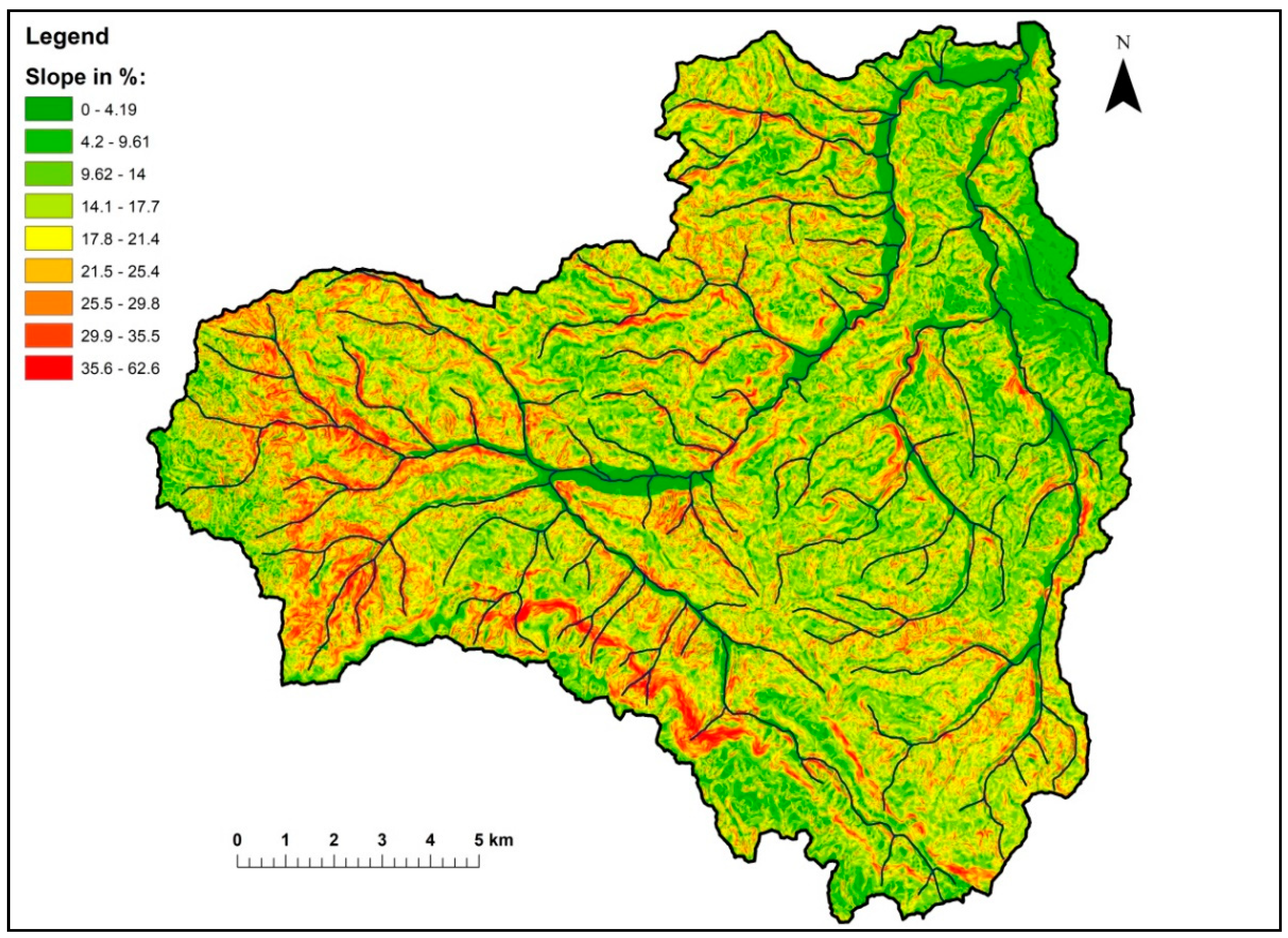
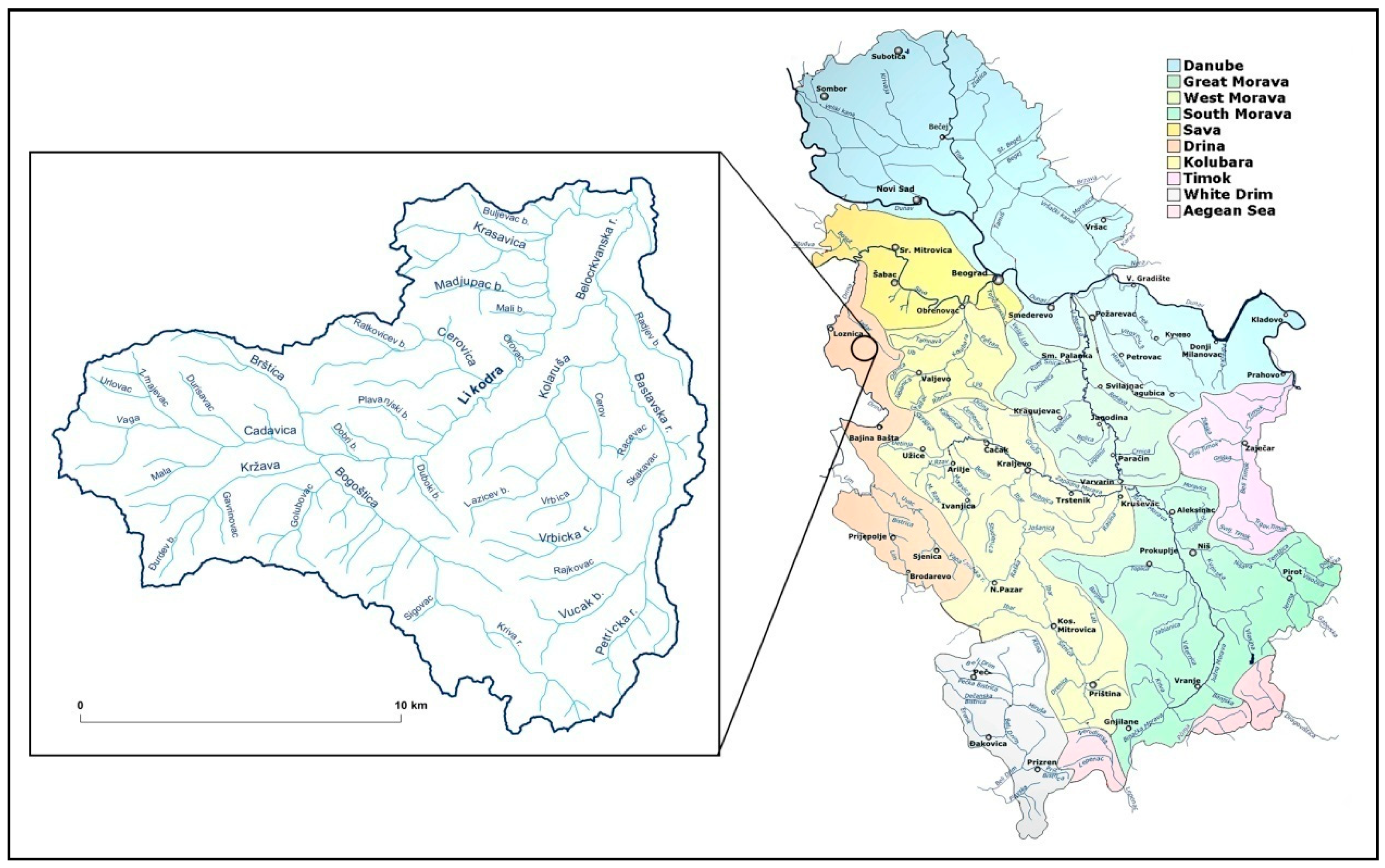
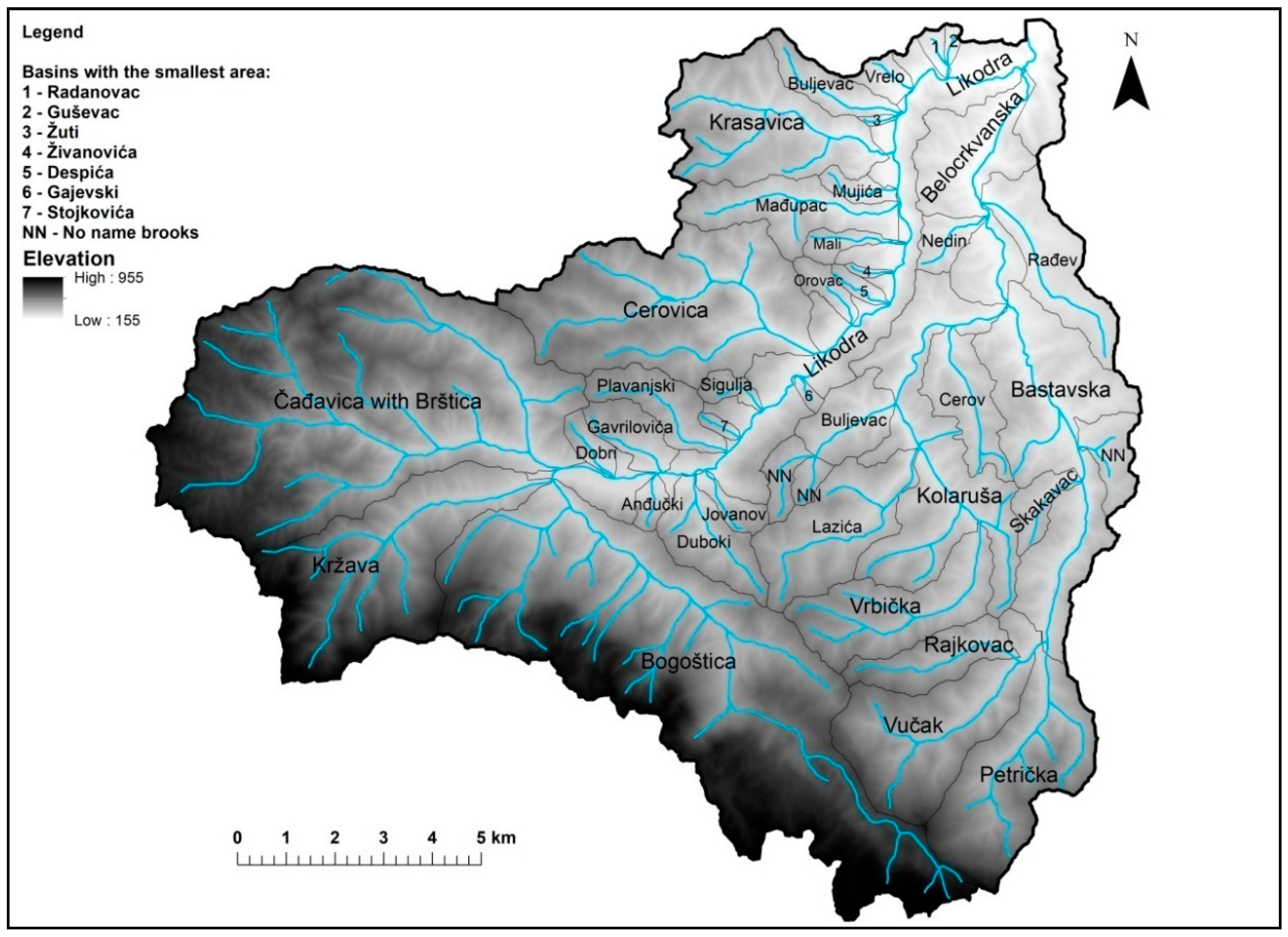
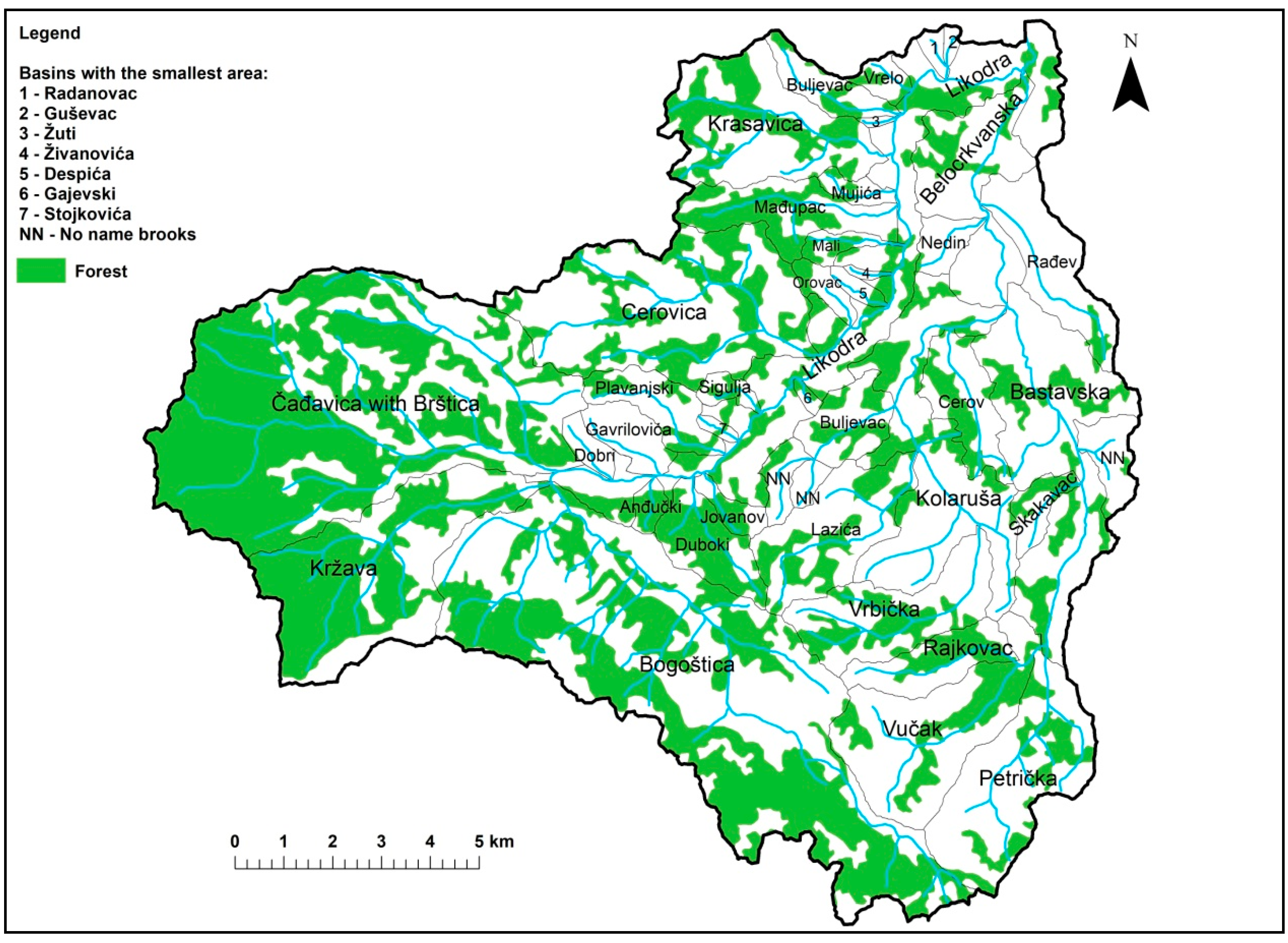
3. Geographical Location and Characteristic of the Basin
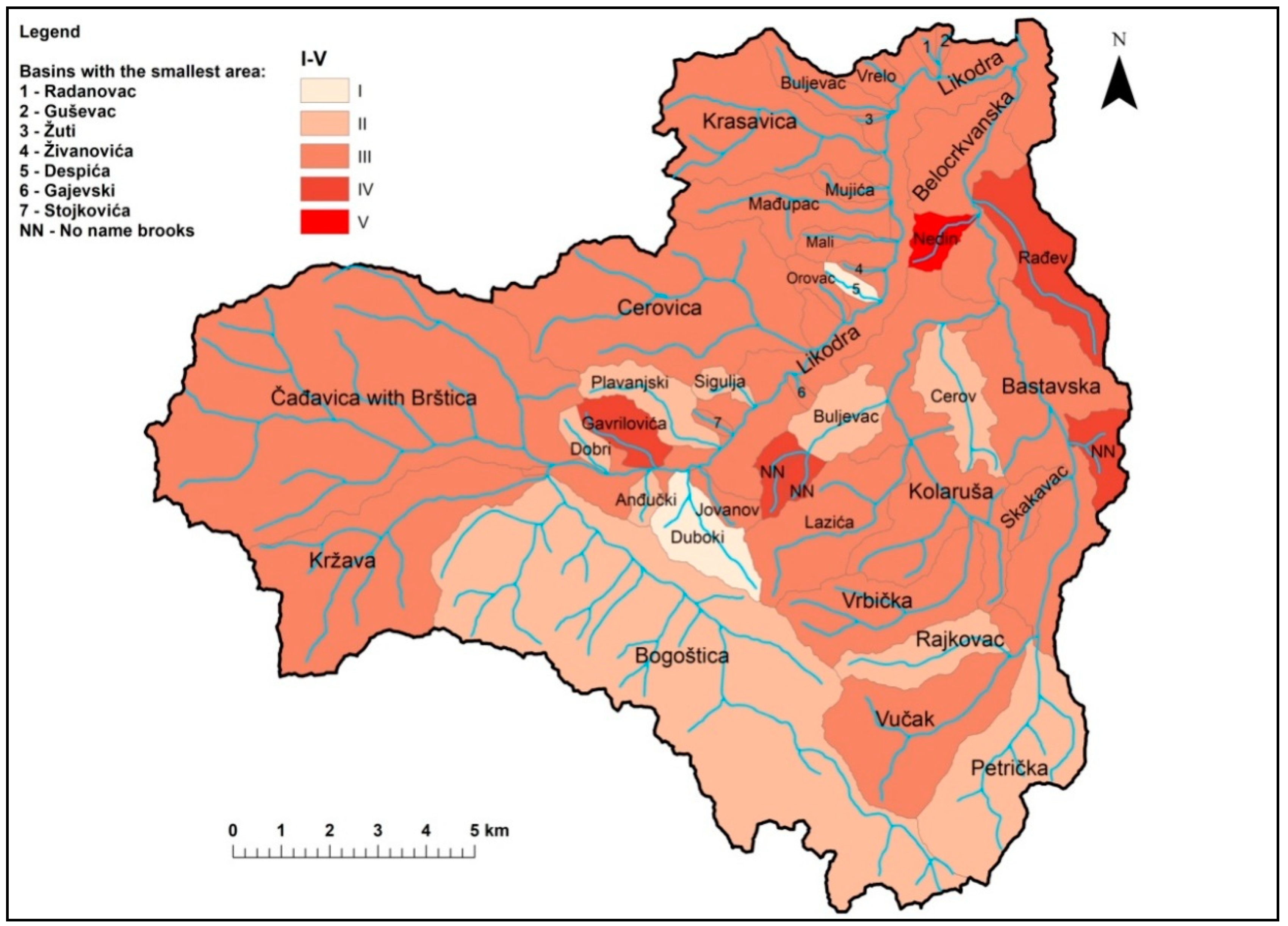
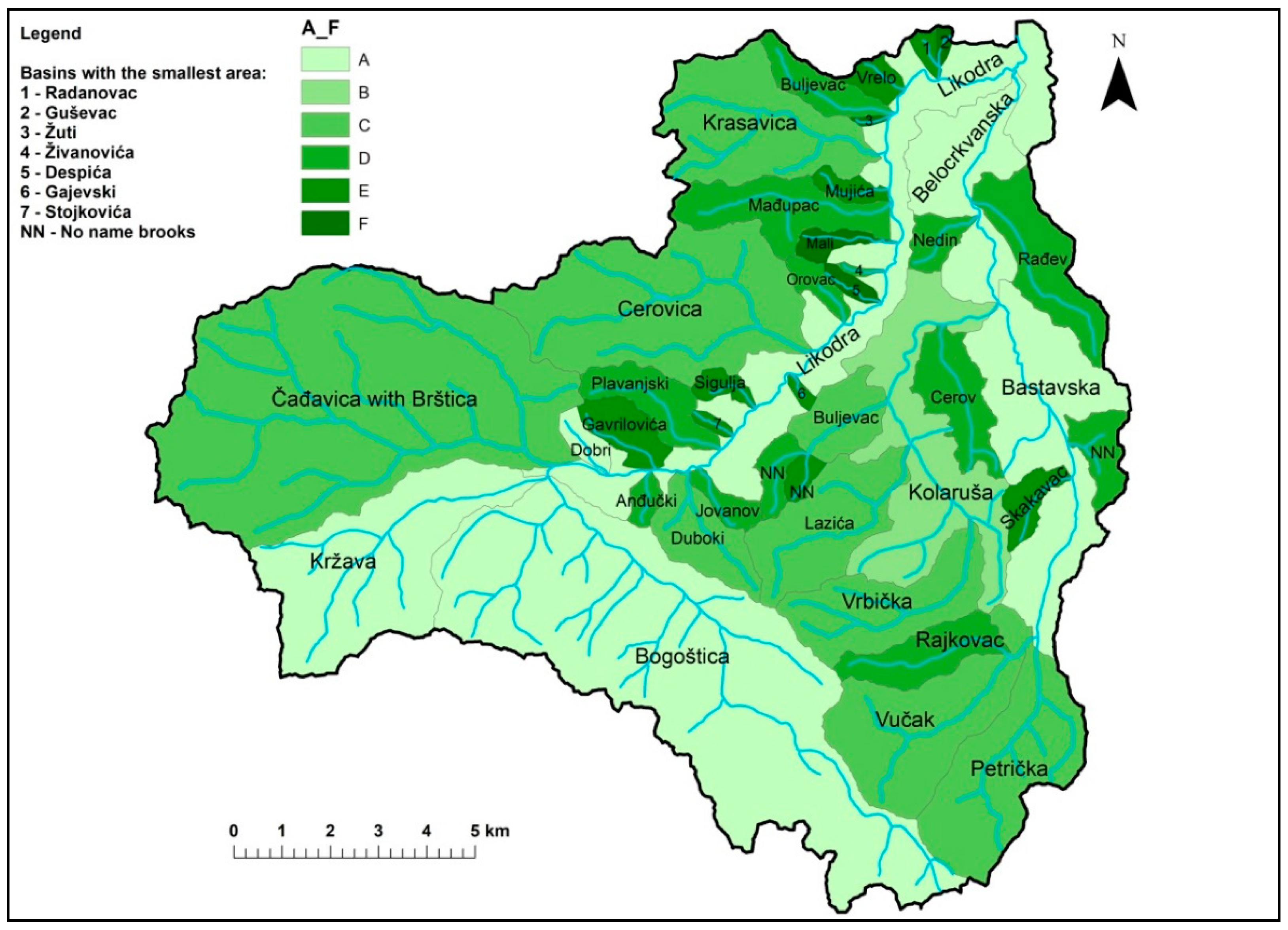
Micro-region Rađevina is in the west part of the Republic of Serbia. Rađevina is a small area which many researchers classify within a larger area—Jadar, to which the basin of the river with the same name corresponds (Figure 1).
The river Likodra is the biggest left tributary of the river Jadar. The river Likodra is formed in Krupanj out of a two confluences of four smaller rivers, the first confluence of the Bogoštica with Kržava and the second confluence of the Čadjavica with Brštica. The river Likodra basin is divided from the river Drina basin on the south and south-west side by the mountains Jagodnja and Sokol with their peaks Mačkov Kamen (elevation 923m) and Rožanj (elevation 971 m). The east part of the river Likodra basin has common borders with the Pecka river basin. The length of the river Likodra, from its forming point in Krupanj to its mouth where it empties into the Jadar river is 17 km and it is the longest tributary of the river Jadar. The Likodra river is the largest river in Rađevina with the surface of its basin being 212.5 km2.
The Likodra river basin morphology is formed by tectonic and geomorphologic processes, respectively. The Likodra river is formed in Krupanj and from that point downstream it flows through a broader part of the valley (the length of 6.5 km) up to the point where it turns abruptly and forms the meander after which it flows into the 3 km long canyon. At the exit point of the canyon, the Likodra river flows through the wide valley up to its mouth where it empties into the Jadar river. The features of the Likodra river course contribute to the composite character of its valley (Figure 2).
Geographical monitoring and quantitative parameters (relief, hydrological and climatological) show that fluvial erosive process in the Likodra river basin is very strong. Additionally, their intensity is increased by high water levels and torrential storms that emerge after heavy precipitation.
Hill torrents occur frequently on the territory of Rađevina. The indirect basin of the Likodra river comprises 30 torrential streams. The area of the catchment is 196.90 km², which represents 57.6% of the total area of the municipality, i.e., the part of the municipality exposed to hill torrents and natural hazards caused by them (torrential floods, landslides, slumps, rock falls).

4. Results

Morphometric characteristics of the basin and the watercourse of the Likodra river were calculated using a software package ArcGIS 10.1 (Esri:Redlands, CA, USA). Calculations were made based on digitized topographic maps of Krupanj (a 1:25,000 scale) and a digital elevation model (DEM) (Table 3; Figure 3).
Watercourses in the Likodra river basin have two basic hydrologic characteristics which have a significant impact on fluvial erosion processes and formation of erosive and accumulative fluvial shapes. The first one is the torrential prone attribute and the second one frequent occurrence of sudden and relatively short torrential floods, with their specific feature of high concentration of solid material which is transported by water. Those characteristics have notably contributed to the evolution of the river beds and valleys.
The Gavrilović analytical method for examining the fluvial process which occurs in the river Likodra basin refers to the quantitative determination of parameters according to which we classify individual river basins into certain erosion types (Table 4).
In the Likodra river basin, there are erosive processes from category I to IV, i.e., from very weak to strong (Figure 4). In the lowland part of the Likodra river basin, there is a separate category—alluvium, where incoming deposits (accumulation) are higher than outgoing deposits (erosion). From field analysis of the granulation metric composition of deposits in the beds of the river Likodra and its tributaries, it may be concluded that surface type of erosion is predominant in the whole basin.
There are small torrential streams, gullies and landslide basins that dominate in the Likodra river basin. Then follow, in a slightly smaller percentage, torrential streams and ravines. There are no torrential rivulet class tributaries in the catchment area of the Likodra river. However, three main rivers that form the Likodra river are classified into the group of torrential river class. The parameters from Table 4 classify the Likodra river into a group of torrential rivers (Figure 5).
Due to the high falls and short lengths of the watercourses in the river Likodra basin, most of them give rise to badlands topography and torrential streams classes (33.33%), whereas the slightly smaller percentage is assigned to the class of slump basins which comprise almost a quarter of all watercourses in the Likodra river basin (23.52%). Those brooks destroy significant quantities of productive land and activate many concealed landslides by their erosive activity. A significant amount of erosive activity in the Likodra river basin is made by torrential streams which belong to hydrographic class C (17.64%). All of the three mentioned classes belong to the highland basins in which the vertical component of fluvial erosion is expressed, i.e.,downcutting. The other hydrographic classes are mostly connected with lower elevations, valley and depression parts of the Likodra rivers basin, with the dominating amount of horizontal erosion which results in the widening of the river bed and the river valley.

5. Discussion

The changes in social-economic relations which occurred after the Second World War also produced certain alternations in agricultural activities in many regions of Europe. Furthermore, those changes triggered a series of consequences: reduction of forest size, increase in agricultural land size, increase in erosive processes intensity in the river basins, and increase in the output of deposits in the basins and alluvial plains. As a result, there were changes in the river dynamics and river morphology [30,31,32,33]. Numerous studies investigated the effects of deforestation and intensified the erosion of agricultural land [34] reduction of nutriments of the land, hill-side stability [35,36] and land characteristics [37].
All studies mentioned above perceived a qualitative connection between the changes in land utilization and changes in river morphology. However, quantitative evaluations of changes in the water balance and deposit yield occasionally remain unavailable. As a result, most of the case studies do not offer sufficient information for the identification of the limiting values in land use that initiate the changes in river morphology. Finally, the application of various models of the spatial distribution of erosion and increase in deposit yield successfully lead to the adequate simulation of the impact of changes in land utilization on deposit intensity. The application of various models provides parameters that quantify the change in the basin dynamics. Some modelling of erosion intensity was conducted earlierin [38] and [39]; however, most of the models did not offer detailed entrance geographic parameters, or the entrance geographic parameters were not available for the whole basin, as was the case with the Gavrilović model. According to studies [11,12], this method can be characterised as a semi-quantitative method because it is based on a combination of descriptive and quantitative procedures. However, compared to other semi-quantitative methods, this method is the most quantitative because it uses descriptive evaluation for three parameters only: soil erodibility, soil protection and extent of erosion in the catchment. All other parameters are quantitative catchment descriptors [13].
The greatest part of the Likodra river basin was used as arable land. The total surface of arable land comprises 89.40 km2 or 42.07%, with the largest portion at the lower and middle parts of the basin. The arable land at the source of the river has a higher inclination, which enables washing away and carrying soil particles which further accelerates the intensity of erosive processes. The forests cover one-third of the basin, i.e., 71.80 km2 or 33.78%. The most represented vegetation is beech forest (on colder mountain slopes), whereas the warmer slopes are oak forest habitats. From the economic point of view, the forests are of low quality, however with good composition and a protective role in possible land erosion. The arable land and forests cover three-fourths of the total basin area, whereas the distribution of other classes is the following: meadows and pastures—31.85 km2 (14.98%); orchards—17.50 km2 (8.25%); and vineyards—0.41 km2 (0.19%). The rest of the basin area is bare mountainous terrain—1.54 km2 (0.73%) (Figure 6).
After the application of the Gavrilović model, which proved itself as the best in the Balkan Peninsula, the authors propose the following measures to prevent harmful effects in the river Likodra basin:
  • To regulate the riverbed of torrential streams that threaten the settlements and industrial facilities;
  • To plant forests on the terrains affected by I and II erosion process categories (excessive and strong erosion processes);
  • To introduce advanced agro-technical measures in the areas with III and IV erosion process category, and to exceptionally permit crops in the areas with above 25° inclination with the obligatory introduction of contour bunding practice in agriculture;
  • To take advantage of all the benefits of cross-sections in torrential stream beds for intensive construction of small water reservoirs to prevent the flooding and the economic exploitation of waterfrom torrential streams for local irrigation, development of tourism, fishery and other economic purposes;
  • To combat the deep erosion processes in torrential stream beds (landslides, landslips, rockfall, and ravines) by building a series of appropriate modern dams: partition structure and leachate drainage system.

6. Conclusions

According to the applied model, analysis of the watercourses in the river Likodra basin was conducted. The implementation of integral management for the whole basin area was proposed as the most economic solution. It is necessary to apply erosion protection and prevention procedures and regulate the river beds of the torrential streams. Application of these procedures would eliminate current and future damage from erosion and the waters of torrential streams could be used in agriculture, tourism, and recreation without negative impact.
Implementation of these proposed models would prevent greater damage from the torrential floods and erosion of sediment. The consequence of reducing the negative impacts leads to lowering geohazard risks for the local population and creating greater opportunities for more intensive farming which is the leading economic activity of the inhabitants in the river Likodra basin.
All of the above also implies the concept of integrated management of torrential basins that would include design and construction of technical (dams, steps, regulations, micro-accumulations, retentions, embankments), biotechnical (sanitation of ravines, protection of the inclined areas) and biological objects (forestation of bare areas, melioration of degraded forests, meadows and pastures, planting orchards on terraces), as well as the application of administrative measures (organisational rules, utilisation and protection of land in endangered basins). Additionally, the maintenance of the present systems for torrential floods and erosion protection and prevention (cleaning the river beds from deposits, vegetation and garbage; revitalisation of damaged objects) were not conducted in a timely manner which significantly reduced the efficiency of the systems [40]. It is evident that the application of preventive and protection measures demands the introduction of Geographic Information System into the sphere of water management.

Author Contributions

Conceptualization, B.R.; methodology, B.R. and Đ.M.; formal analysis, B.R., M.C., M.O. and R.F.; writing—original draft preparation, B.R. and Đ.M.; visualization, M.C., M.O. and R.F.; writing—review and editing B.R., Đ.M. and M.C.

Funding

This research received no external funding

Conflicts of Interest

The authors declare no conflict of interest.

Appendix A

Table A1. Quantitative indicators of the Gavrilović method.
IndexQuantitative IndicatorsMeasure
FTorrential catchment areakm2
LLength of the main torrential flowkm
OLength watershed basinkm
DAverage height difference of basin or area covered by erosionm
ACoefficient of basin shape-
S1Coefficient of water-permeability-
S2Coefficient of vegetation covering-
WAnalytic expression of retentionm2/km
QmaxMaximum quantity of waterm3/sec
GProduction of deposit from one km2 of the basinm3/km
ZErosion coefficient
∑LLength of the main contour lineskm
IsrIntermediate slope basin
T0Average annual temperature
HgodMean annual rainfallmm
LhmLength tributary I and IIkm
LgtLength of the main torrential flowkm
KClimatic and topographical coefficient-
HkHydrographic classA,B,C,D,E,F

References

  1. Ristić, R. Redefining the policy of torrential flood prevention in Serbia. J. Public Policy 2014, 8, 23–28. [Google Scholar]
  2. Staut, M. Recent Erosional Processes in the Catchment of the Dragonja River. Unpublished graduate thesis, University of Ljubljana, Ljubljana, Slovenia, 2004. [Google Scholar]
  3. Cook, H.L. The nalure and controlling variables of the water erosion process. Soil Sci. Soc. Am Proc. 1936, 1, 60–64. [Google Scholar]
  4. Zingg, A.W. Degree and length of land slope as it affects soil loss in runoff. J.Agric. Eng. 1940, 21, 59–64. [Google Scholar]
  5. Smith, D.D. Interpretation of soil conservation data for field use. J. Agric. Eng. 1941, 22, 173–175. [Google Scholar]
  6. Poljakov, B.V. Problemi Ruslovih Processov; Moskva, Russia, 1953. (In Russian) [Google Scholar]
  7. Herheulidze, I. Ovraniei Selevie Vinosi; Moskva, Russia, 1947. (In Russian) [Google Scholar]
  8. Browning, G.M.; Parish, C.L.; Glass, J. A method for determining the use and limitations of rotation and conservation practices in the control of soil erosion in Iowa. J. Am. Soc. Agron. 1947, 39, 65–73. [Google Scholar] [CrossRef]
  9. Silvestrov, S.I. Reljefi Zemljedelijev Erozionih Rajonah; Moskva, Russia, 1955. (In Russian) [Google Scholar]
  10. Wischmeier, W.H.; Smith, D.D. Predicting Rainfall-Erosion Losses from Cropland East of Rocky Mountains—Guide for Selection of Practices for Soil and Water Conservation; U.S. Department of Agriculture, Agricultural Handbook 282; Agricultural Research Service: Washington, DC, USA, 1965.
  11. De Vente, J.; Poesen, J. Predicting soil erosion and sediment yieldat the basin scale: Scale issues and semi-quantitative models. Earth-Sci. Rev. 2005, 71, 95–125. [Google Scholar] [CrossRef]
  12. Eisazadeh, L.; Sokouti, R.; Homaee, M.; Pazira, E. Comparison ofempirical models to estimate soil erosion and sediment yield inmicro catchments. Eurasian J. Soil Sci. 2012, 1, 28–33. [Google Scholar]
  13. Dragičević, N.; Karleuša, B.; Ožanić, N. A review of the Gavrilović method (erosion potential method) application. Građevinar J. Croat. Assoc. Civ. Eng. 2016, 68, 715–725. [Google Scholar]
  14. Gavrilović, S. A method for estimating of the average annual quantity of sediments according to the potency of erosion. J. Fac. For. 1962, 26, 151–168. [Google Scholar]
  15. Gavrilović, S. Modern methods of calculating torrents sediment and production of erosion maps. In Erosion, Torrents and Alluvial Deposits, Proceeding of the Seminar Erosion, Torrents and Sediment; Belgrade, Serbia, 1970; pp. 85–100. [Google Scholar]
  16. Gavrilović, S. Engineering of torrents and erosion, Special edition. J. Constr. 1972, 1–292. [Google Scholar]
  17. Lazarević, R. Scientific-research work and problems in prevention measures against soil erosion and torrential erosion. In Proceedings of the Symposium on the Problems of Erosion in the Federal Republic of Serbia, Beograd, Serbia, 25–28 October 1967; pp. 35–46. [Google Scholar]
  18. Lazarević, R. The new method for erosion coefficient determination—Z. Erosion-Prof. Inf. Bull. 1985, 13, 54–61. [Google Scholar]
  19. Pintar, J.; Mikoš, M.; Verbovšek, V. Elements of the water management—Alternative to narrowing of live natural processes in rigid objects. In Second Congress of the Waters of Yugoslavia; Simonović, S., Ed.; Yugoslav Society for Drainage and Irrigation: Belgrade, Serbia, 1986; Volume 4, pp. 800–814. [Google Scholar]
  20. Amini, S.; Rafiei, B.; Khodabakhsh, S.; Heydari, M. Estimation of еrosion and sediment yield of Ekbatan Dam drainage basin with EPM, using GIS. Iran. J. Earth Sci. 2010, 2, 73–180. [Google Scholar]
  21. Gavrilović, Z.; Stefanović, M.; Milovanović, I.; Čotrić, J.; Milojević, M. Torrent classification—base of rational management of erosive regions. In IOP Conference Series: Earth and Environmental Science; IOP Publishing: Bristol, UK, 2008; Volume 4, pp. 1–8. [Google Scholar]
  22. Tošić, R.; Dragićević, S. Methodology update for determination ofthe erosion coefficient. J.Serb. Geogr. Soc. 2012, 92, 11–26. [Google Scholar]
  23. Globevnik, L.; Holjević, D.; Petkovšek, G.; Rubinić, J. Applicability of the Gavrilović method in erosion calculation using spatial data manipulation techniques. In Erosion Prediction in Ungauged Basins: Integrating Methods and Techniques, IAHS publication 279; De Boer, D.H., Ed.; International Association of Hydrological Sciences: Wallingford/Oxfordshire, UK, 2003; pp. 224–233. [Google Scholar]
  24. Ristanović, B.; Miljanović, B.; Cimbaljević, M.; Pankov, N.; Živković, M.; Popovic, A. Determining hydrological problems using GIS, Case study Krasavica. In Proceedings of the 47th Annual conference of the Serbian Water Pollution Control Society, WATER 2018, Soko Banja, Serbia, 12–14 June 2018; pp. 255–262. [Google Scholar]
  25. Mikoš, M.; Fazarinc, R.; Ribičič, M. Sediment production and delivery from recent large landslides and earthquake-induced rock falls in the Upper Soča River Valley, Slovenia. Eng. Geol. 2006, 86, 198–210. [Google Scholar] [CrossRef]
  26. Gavrilović, Z. The importance of laboratory tests in the experimental study of soil erosion. In Irrigation and Drainage in Serbia, Proceedings of Counseling; Svilajnac, Serbia, 1994; pp. 327–331. [Google Scholar]
  27. Gavrilović, Z. The use of empirical method (erosion potential method) for calculating sediment production and transportation in unstudied or torrential streams. In International Conference on River Regime; White, W.R., Ed.; Hydraulics Research Limited: Wallingford/Oxfordshire, UK, 1988; pp. 411–422. [Google Scholar]
  28. Water Base River Jadar; Water Management Organization “Loznica”: Loznica, Serbia, 1970; Volume IV, p. 123.
  29. Lazarević, R. Landslides; Yugoslav Society for the Protection of the torrent: Beograd, Serbia, 2000. [Google Scholar]
  30. Lièbault, F.; Gómez, B.; Page, M.; Marden, M.; Peacock, D.; Richard, D.; Trotter, C.M. Land-use change, sediment production and channel response in upland region. Rivers Res. Appl. 2005, 21, 739–756. [Google Scholar]
  31. Keesstra, S.D.; Van Dam, O.; Verstraeten, G.; van Huissteden, J. Changing sediment dynamics due to natural reforestation in the Dragonja catchment, SW Slovenia. Catena 2009, 78, 60–72. [Google Scholar] [CrossRef]
  32. Piégay, H.; Walling, D.E.; Landon, N.; He, Q.; Liébault, F.; Petiot, R. Contemporary changes in sediment yield in an alpine mountain basin due to afforestation (the upper Drôme in France). Catena 2004, 20, 183–212. [Google Scholar]
  33. Devkota, K.C.; Regmi, A.D.; Pourghasemi, H.R.; Yoshida, K.; Pradhan, B.; Ryu, I.C.; Dhital, M.R.; Althuwaynee, O.F. Landslide susceptibility mapping using certainty factor, index of entropy and logistic regression models in GIS and their comparison at Mugling-Narayanghat road section in Nepal Himalaya. Nat. Hazards 2013, 65, 135–165. [Google Scholar] [CrossRef]
  34. Singh, R.B. Land use/cover changes, extreme events and ecohydrological responses in the Himalayan region. Hydrol. Process. 1999, 12, 2043–2055. [Google Scholar] [CrossRef]
  35. Lenhart, T.; Fohrer, N.; Frede, H.G. Effects of land use changes on the nutrient balance in mesoscale catchments. Phys. Chem. Earth Parts A/B/C 2003, 28, 1301–1309. [Google Scholar] [CrossRef]
  36. Vanacker, V.; Vanderschaeghe, M.; Govers, G.; Willems, E.; Poesen, J.; Deckers, J.; De Bievreet, B. Linking hydrological, infinite slope stability and land-use change models through GIS for assessing the impact of deforestation on slope stability in high Andean watersheds. Geomorphology 2003, 52, 299–315. [Google Scholar] [CrossRef]
  37. Varela, M.E.; Blas, E.D.; Benito, E. Physical soil degradation induced by deforestation and slope modification in a temperate–humid environment. Land Degrad. Dev. 2001, 12, 477–484. [Google Scholar] [CrossRef]
  38. Martínez-Casasnovas, J.A.; Sánchez-Bosch, I. Impact assessment of changes in land use/conservation practices on soil erosion in the Penedès–Anoia vineyard region (NE Spain). Soil Tillage Res. 2000, 57, 101–106. [Google Scholar] [CrossRef]
  39. Erskine, W.D.; Mahmoudzadeh, A.; Myers, C. Land use effects on sediment yields and soil loss rates in small basins of Triassic sandstone near Sydney, NSW, Australia. Catena 2002, 49, 271–287. [Google Scholar] [CrossRef]
  40. Ristanović, B.; Živković Bubalo, M.; Tanasić, J.; Popović, A. Monograph of Municipality Krupanj; Department of Geography, Tourism and Hotel Menagment: Novi Sad, Serbia, 2016. [Google Scholar]
Figure 1. Geographical location of the Likodra basin in Serbia (1:1.500,000 scale map).
Atmosphere 10 00526 g001
Figure 2. Relief of the Likodra river basin.
Atmosphere 10 00526 g002
Figure 3. Slopes in the Likodra river basin.
Atmosphere 10 00526 g003
Figure 4. Intensity erosion categories in the Likodra river basin.
Atmosphere 10 00526 g004
Figure 5. Hydrographic classes in the Likodra river basin.
Atmosphere 10 00526 g005
Figure 6. Forest areas in theLikodrariver basin.
Atmosphere 10 00526 g006
Table 1. Formulas for configuration terrain analysis.
Average altitude of basin or erosive areaNsr = (f1 × h1 + f2 × h2 +…….fn × hn)/F
Average height difference of basin or area covered by erosionD = Nsr − Nu
Coefficient of basin shapeA = O/L × ( π + 2) = 0,195 × O/L
Average basin fallJsr = WL × h/F
Table 2. Formula for analysis of geologic, hydro-geologic, pedologic and vegetation conditions of the area.
Coefficient of water-permeabilityS1 = 0,4 × fp + 0,7 × fpp + fnp
Coefficient of vegetation coveringS2 = 0,6 × fš + 0,8 × ft + 1,0 × fg/F
Analytic expression of retentionW = y × h2/L
Maximum quantity of water
(which runs out by erosive basin)
Qmax = A × S1 × S2 × W × 2 gDF
Production of deposit
from one km2 of the basin
G = To × Hgod × π × Z3/2
Table 3. Quantitative indicators of torrential streams in the Likodra river basin.
ConfluenceF
(km2)
L
(km)
O
(km)
D
(m)
AS1S2WQmaxGZΣLISRToLhm + 1
Lgt + 1
KHkI–VA–F
Slope and Interconfluences from Emptier to Orovac Brook3.75
Radanovac Brook0.471.003.00370.580.700.880.724.811238.180.551.000.211.0440.500.470.06IIIE
Guševac Brook0.300.752.00600.520.700.900.734.501238.180.550.400.131.0440.660.370.04IIIF
Brelo Brook0.571.753.50920.390.610.790.724.351238.180.551.250.221.0440.660.490.07IIIE
Buljevac Brook1.843.206.751390.410.740.880.7113.54826.260.425.500.301.0440.250.570.11IIID
Žuti Brook0.120.701.70630.470.610.720.731.831446.220.610.300.251.0440.710.520.02IIIF
Krasavica8.505.2512.251600.460.400.850.7018.091590.780.6521.00.251.0440.830.521.69IIIC
Mujića Brook0.571.303.75690.560.550.850.725.281517.930.631.250.221.0440.500.490.08IIIE
Mađupac Brook3.604.6011.501690.490.550.860.7117.981105.590.5111.00.311.0440.550.580.56IIID
Mali Brook0.111.002.50570.490.550.860.721.871238.180.550.500.451.0440.500.700.02IIIF
Živanovića Brook1.051.754.751010.530.550.750.727.211238.180.553.200.301.0440.360.570.11IIID
Otavice Brook0.230.902.50960.540.550.860.723.881238.180.551.000.431.0440.360.680.03IIIF
Despića Brook or Gumina0.321.103.00920.530.400.840.723.124242.341.251.250.391.0440.360.650.04IF
Orovac0.872.004.001290.390.740.820.728.022378.860.853.000.341.0440.520.6090.11IIID
Slope and Interconfluences from Orovac Brook to Čađavica0.33
Cerovica15.187.5019.001860.490.600.830.7040.20855.940.4344.00.291.0441.940.568.11IIIC
Točine0.120.501.501350.580.460.870.733.032378.860.850.500.421.0440.980.670.05IIE
Milinovača Brook0.260.702.501300.700.470.730.734.521238.180.551.000.381.0440.620.640.07IIIE
Sigulja0.521.502.751640.360.460.910.724.472378.860.852.000.381.0440.520.640.06IIE
Stojkovića Brook0.290.902.751560.600.600.740.725.791238.180.551.250.431.0440.570.680.07IIIE
Plavanjski Brook2.303.508.001650.440.720.880.7117.182900.000.977.000.301.0440.550.570.32IID
Gavrilovića Brook1.702.004.751470.460.770.910.7216.30683.190.374.000.241.0440.820.510.33IVE
Dobri Brook0.501.253.00980.470.810.890.727.642295.390.832.000.401.0440.510.660.08IIA
Čađavica with Brštica34.349.2524.502520.520.830.760.6994.071340.860.5898.50.291.0444.950.5649.68IIIC
Kržava12.188.0019.003210.390.570.690.6929.70826.260.4240.50.331.0442.030.605.79IIIA
Bogoštica32.5413.5035.502920.510.510.810.6862.312091.130.78114.000.351.0443.030.6131.08IIA
Interconfluences from Bogoštica to Jovanov Brook4.37
Vujin Brook0.300.902.50860.540.820.850.726.172591.810.901.800.601.0441.050.800.14IID
Anđučki Brook0.501.403.40870.470.790.850.726.722378.860.852.250.451.0440.620.700.10IID
Duboki Brook2.863.007.501380490.760.910.7121.384242.341.258.500.301.0441.470.571.18IC
Jovanov Brook0.601.504.50710.590.750.850.727.881340.850.583.000.501.0441.140.730.30IIID
Slope1.77
Gajevski Brook0.300.802.20840.540.450.790.733.12885.970.440.500.171.0440.830.430.06IIIE
Slope1.76
Belocrkvanska River73.8618.5045.502680.480.640.750.6796.921138.270.52136.80.191.0443.500.4556.46IIIA
Slope1.40
Likodra River212.527.0077.501710.560.670.820.66171.711238.180.5580.30.031.0445.380.18115.8IIIA
Table 4. Hydrographic classes and erosion strength categories of torrents in the Likodra river basin (in %).
River BasinHydrographic ClassesΣIntensity Erosion Categories
ABCDEF IIIIIIIVV
Likodra4-49953128201-
Belocrkvanska River11583220-4610-
Total51917127512122611-
%9.801.9617.6433.3323.5313.721003.9223.5250.9821.560.00

