Detecting Abandoned Cropland in Monsoon-Influenced Regions Using HLS Imagery and Interpretable Machine Learning
Abstract
1. Introduction
2. Materials and Methods
2.1. Study Site
2.2. Overall Workflow
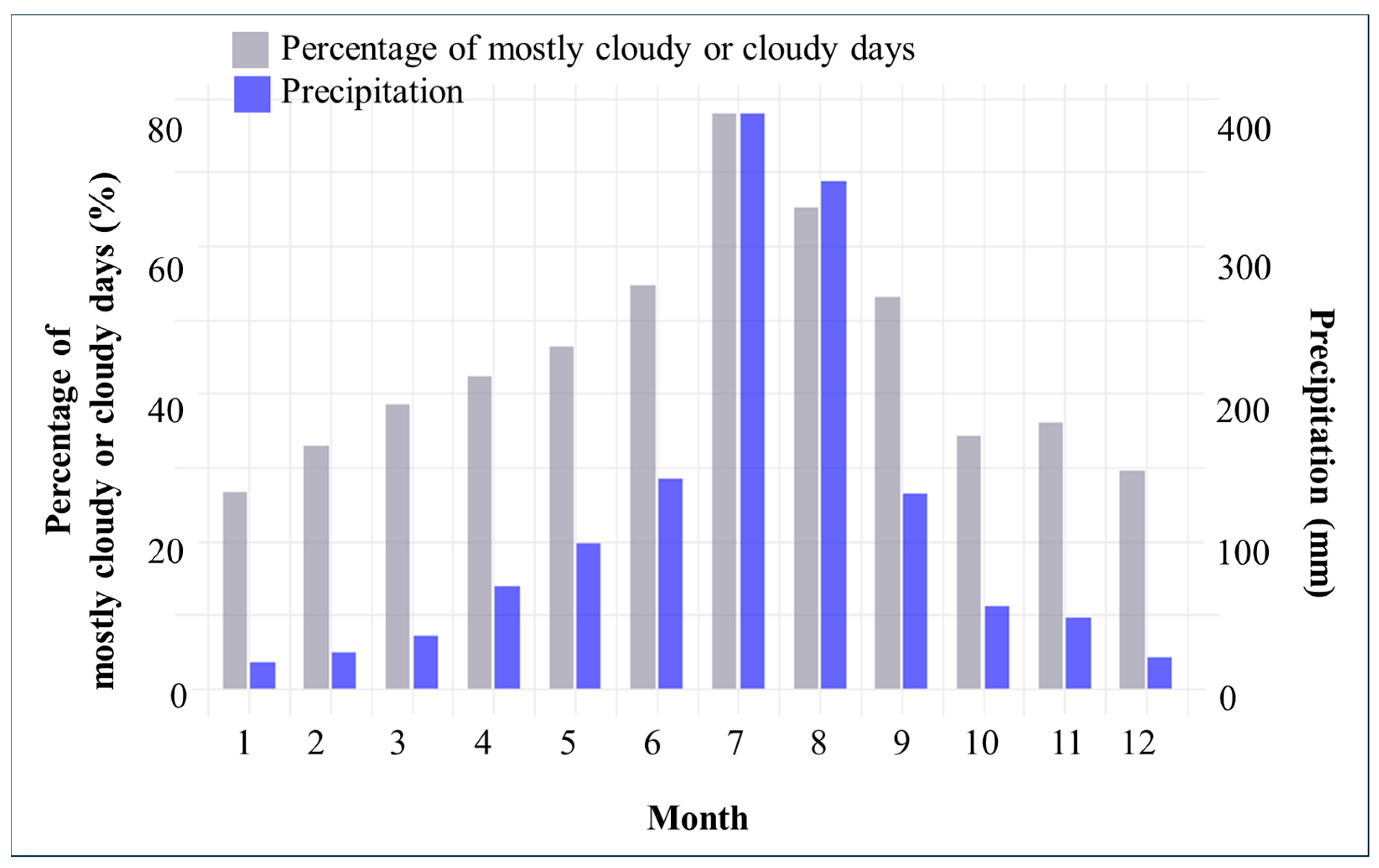
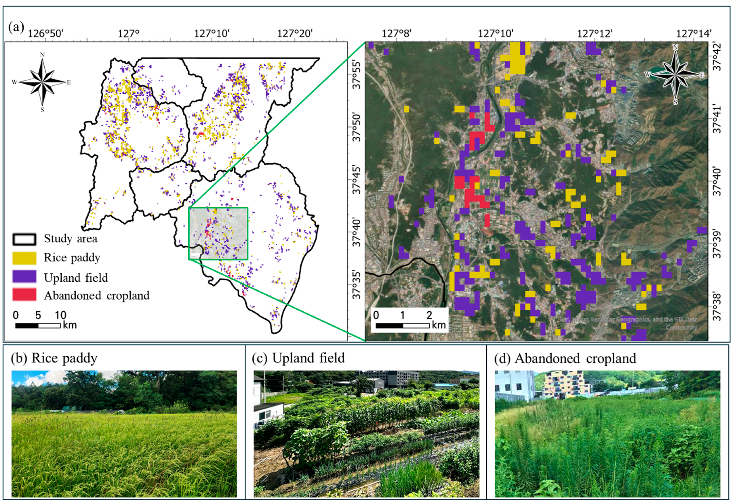
2.3. Data Collection: Field Survey and Satellite Imagery
2.4. Feature Extraction and Selection
| Factor | Description | Formula | Reference |
|---|---|---|---|
| NDVI | Normalized Difference Vegetation Index indicates vegetation greenness and vigor based on red and NIR reflectance. | [45] | |
| SAVI | Soil-Adjusted Vegetation Index is Similar to NDVI but minimizes the influence of soil background. | [46] | |
| NBR | Normalized Burn Ratio Detects burned areas and vegetation stress using NIR and SWIR bands. | [47] | |
| BSI | Bare Soil Index Measures the proportion of bare soil. | [48] | |
| NDWI | Normalized Difference Water Index Highlights surface water content or moisture using NIR and green bands. | [49] | |
| MCARI | Modified Chlorophyll Absorption in Reflectance Index Measures the concentration of Chlorophyll. | [50] | |
| TCG | Tasseled Cap Wetness Represents vegetation abundance derived from the Tasseled Cap transformation. | [51] | |
| TCW | Tasseled Cap Wetness Represents soil and canopy moisture derived from the Tasseled Cap transformation. | [52] | |
| TCWGDinv | It highlights the relative reflectance contrast between the Greenness and Wetness components, providing valuable insights into crop growth and the influence of irrigation and precipitation. | TCG − TCW | [53] |
| RVI | Radar Vegetation Index Quantifies vegetation structure and biomass using VV and VH backscatter; higher values indicate denser canopy. | [54] | |
| VH/VV ratio | Ratio between VH and VV Highlights crop structure and growth dynamics by contrasting volume and surface scattering components. | [39] |
2.5. Development and Evaluation of Korean Abandoned Cropland Detection Model Using XGBoost
3. Results
3.1. Boruta-Based Feature Selection Results
3.2. Model Performance Evaluation
3.3. Global SHAP Value Analysis
4. Discussion
4.1. Model Performance
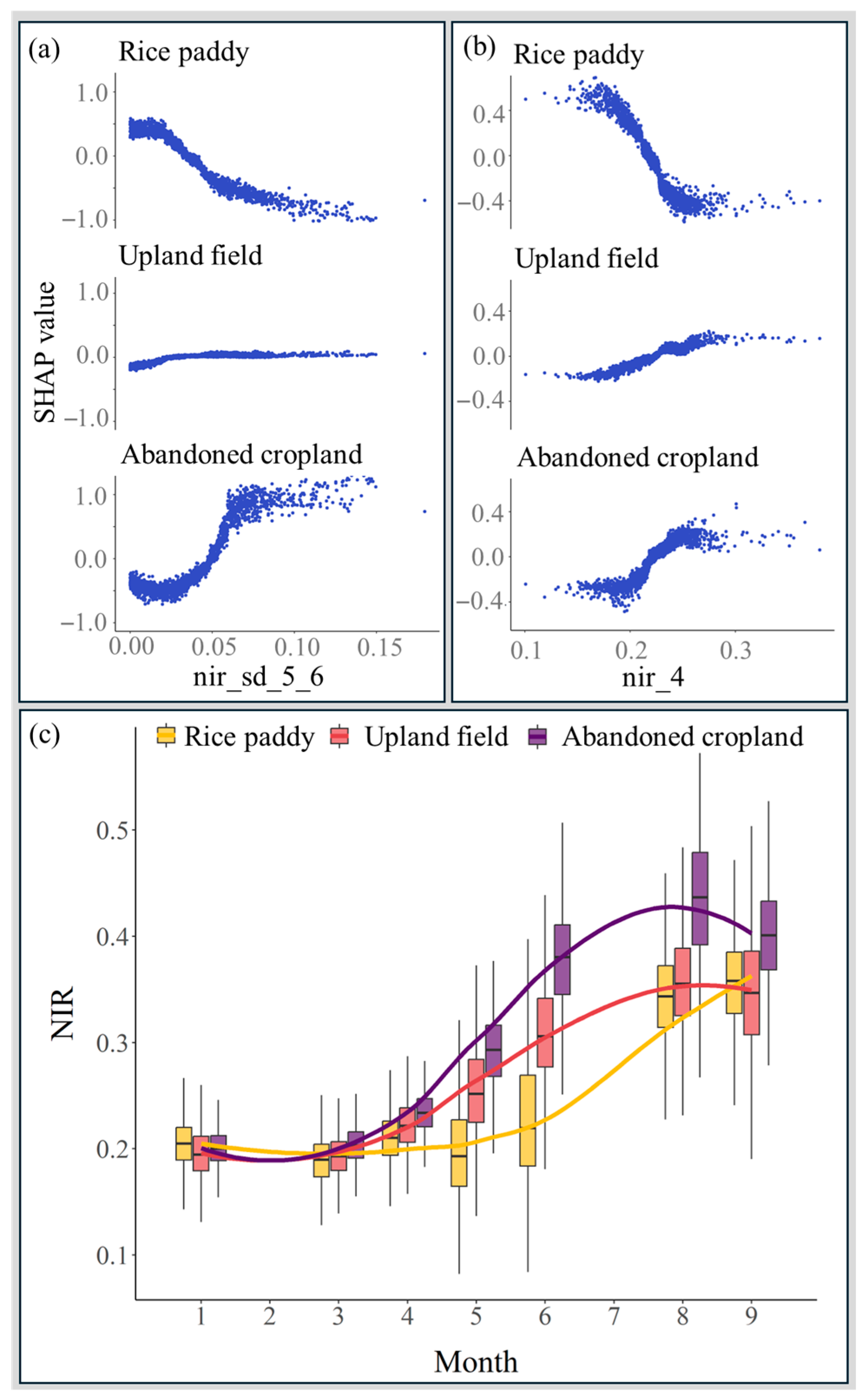
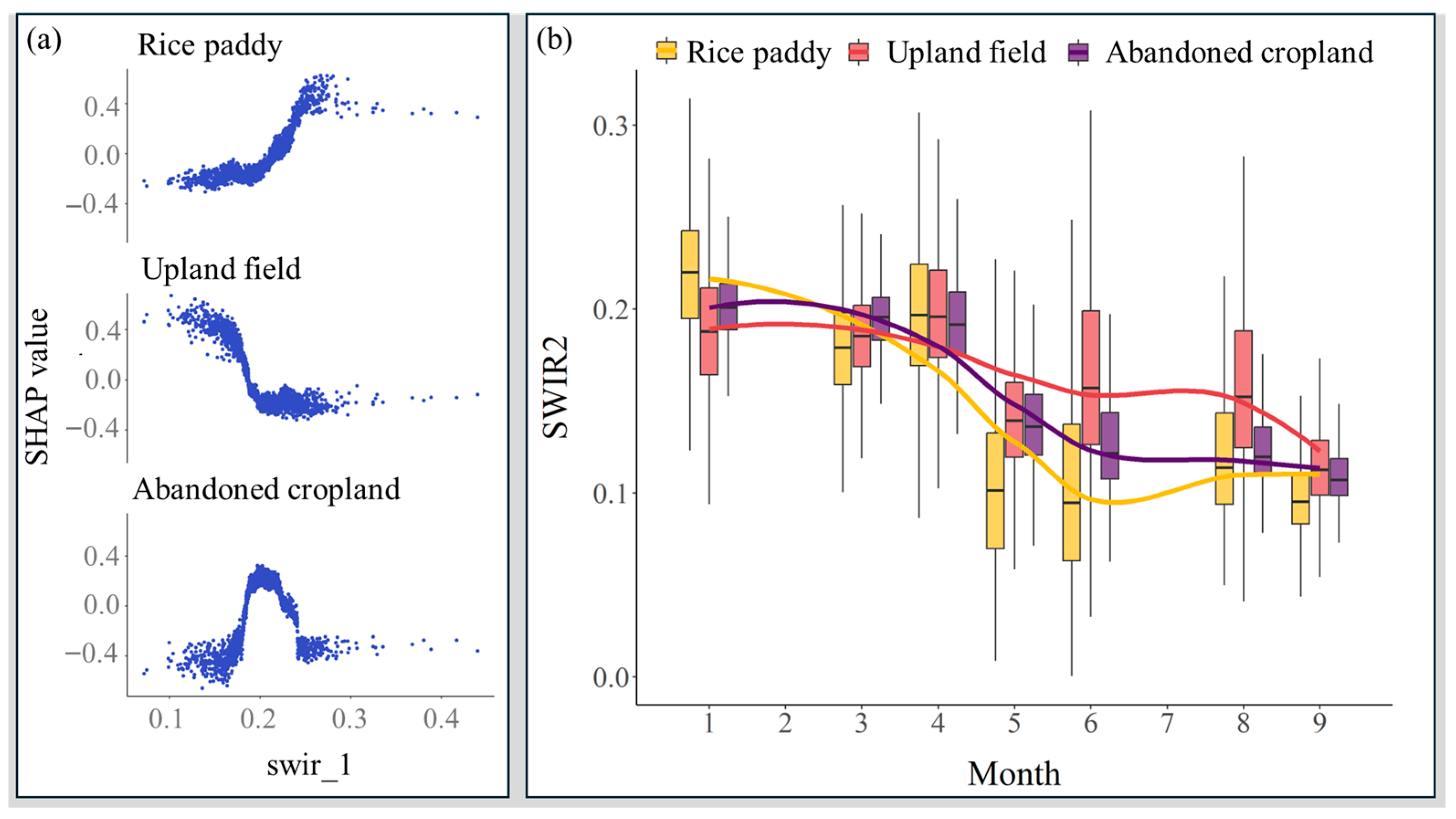
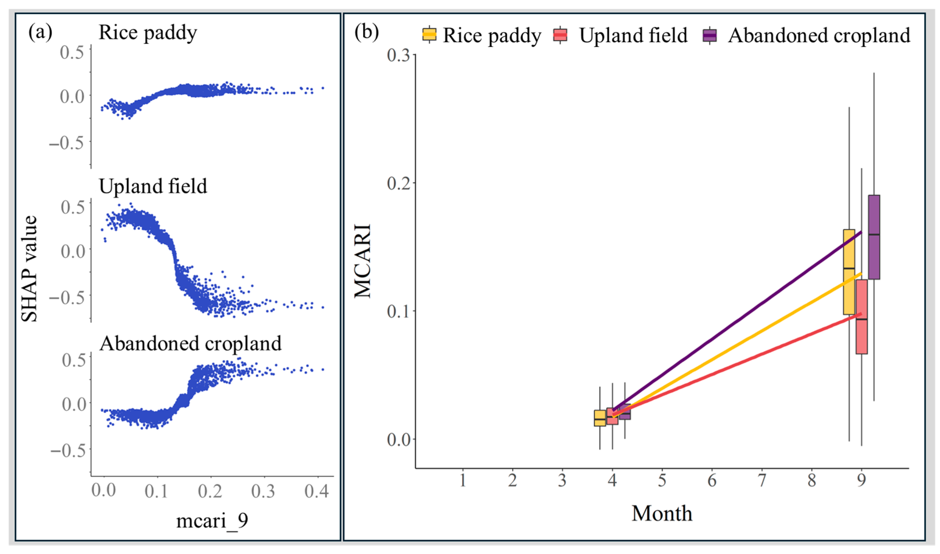
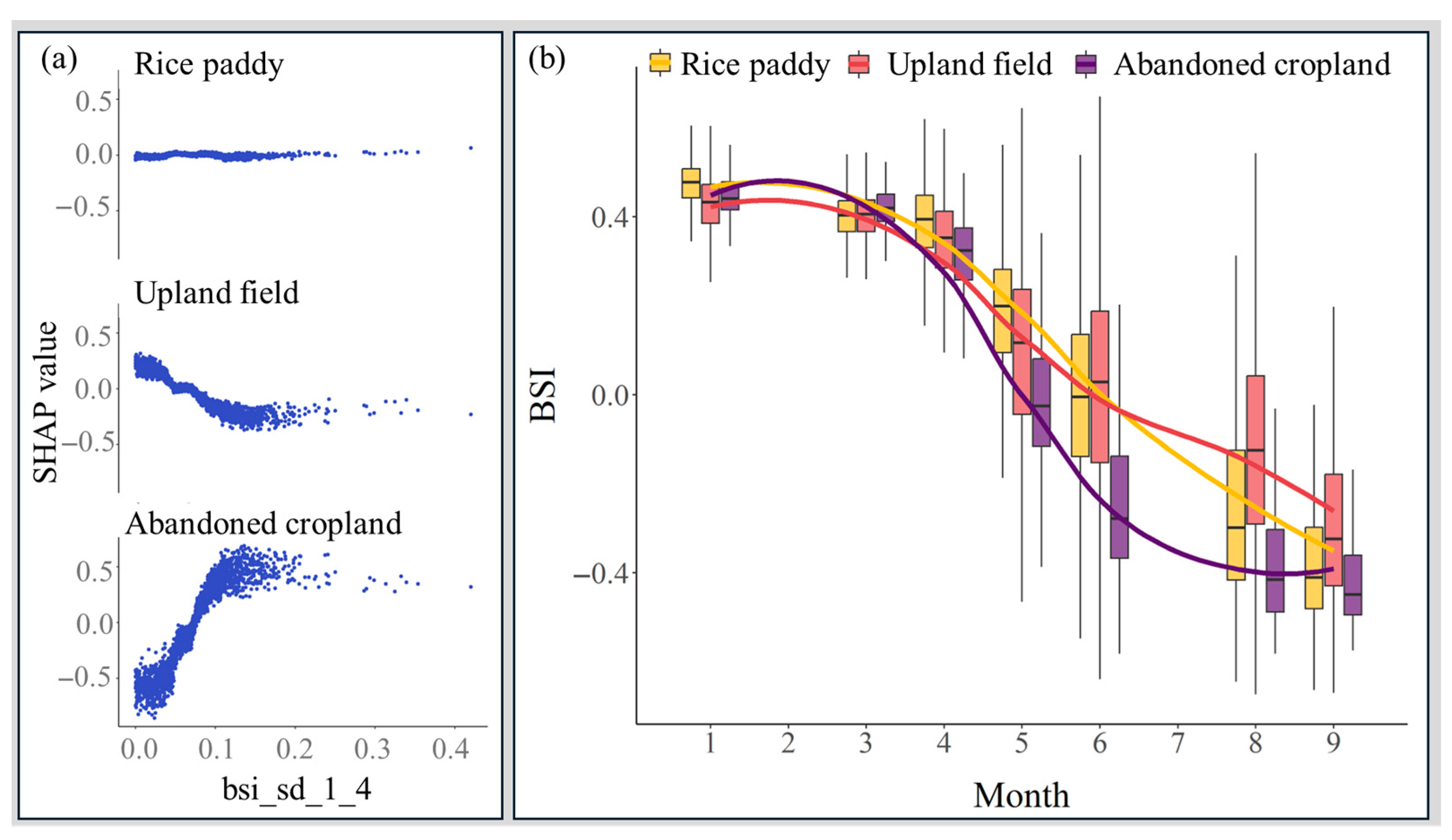
4.2. Variable-Wise SHAP Interpretation
4.3. Limitation of the Study
5. Conclusions
Author Contributions
Funding
Data Availability Statement
Conflicts of Interest
Abbreviations
| HLS | Harmonized Landsat and Sentinel-2 |
| XGBoost | eXtreme Gradient Boosting |
| BBC | Balanced Bagging Classifier |
| XAI | explainable artificial intelligence |
| SHAP | SHapley Additive exPlanations |
Appendix A
Appendix A.1
| Class | Overall Accuracy | |||||
|---|---|---|---|---|---|---|
| Rice paddy | 0.83 | 0.87 | 0.80 | 0.83 | 0.81 | 0.68 |
| Upland field | 0.80 | 0.87 | 0.83 | 0.86 | ||
| Abandoned cropland | 0.65 | 0.76 | 0.70 | 0.73 |
Appendix A.2
| Variable | Description | Variable | Description |
|---|---|---|---|
| tcgwd_sd_1_6 | Standard deviation of TCWGDinv value of January and June | ratio_mean_8_9 | Mean of VV/VH ratio of August and September |
| swir1_sd_5_6 | Standard deviation of SWIR1 reflectance of May and June | tcgwd_sd_4_9 | Standard deviation of TCWGDinv value of April and September |
| red_sd_1_4 | Standard deviation of RED reflectance of January and April | red_sd_6_8 | Standard deviation of RED reflectance of June and August |
| red_sd_3_5 | Standard deviation of RED reflectance of March and May | swir2_1 | SWIR2 reflectance of January |
| red_sd_4_5 | Standard deviation of RED reflectance of April and May | bsi_sd_1_4 | Standard deviation of BSI value of January and April |
| tcgwd_sd_1_3 | Standard deviation of TCWGDinv value of January and March | nbr_sd_5_8 | Standard deviation of NBR value of May and August |
| rvi_mean_5_8 | Mean RVI value of May and August | red_sd_5_6 | Standard deviation of RED reflectance of May and June |
| tcgwd_sd_5_6 | Standard deviation of TCWGDinv value of May and June | nbr_sd_5_6 | Standard deviation of NBR value of May and June |
| blue_sd_5_9 | Standard deviation of BLUE reflectance of May and September | mcari_9 | MCARI value of September |
| green_sd_1_5 | Standard deviation of GREEN reflectance of January and May | nir_sd_1_4 | Standard deviation of NIR reflectance January and April |
| tcgwd_sd_3_4 | Standard deviation of TCWGDinv value of March and April | swir2_sd_3_9 | Standard deviation of SWIR2 Reflectance of March and September |
| tcgwd_sd_1_4 | Standard deviation of TCWGDinv value of January and April | savi_sd_5_6 | Standard deviation of SAVI value of May and June |
| swir1_sd_5_8 | Standard deviation of SWIR1 Reflectance of May and August | nir_4 | NIR reflectance of April |
| ndwi_sd_3_4 | Standard deviation of NDWI value of March and April | red_sd_3_6 | Standard deviation of RED reflectance of March and June |
| swir1_sd_5_9 | Standard deviation of SWIR1 Reflectance of May and September | ratio_mean_5_8 | Mean of VV/VH ratio of May and August |
| nbr_sd_5_9 | Standard deviation of NBR value of May and September | ndvi_sd_1_3 | Standard deviation of NDVI value of January and March |
| nir_sd_3_4 | Standard deviation of NIR reflectance of March and April | swir1_sd_3_8 | Standard deviation of SWIR1 Reflectance of March and August |
| nbr_sd_8_9 | Standard deviation of NBR value of August and September | nir_sd_5_6 | Standard deviation of NIR reflectance of May and June |
| tcgwd_sd_3_8 | Standard deviation of TCWGDinv value of March and August |
References
- Liu, T.; Yu, L.; Liu, X.; Peng, D.; Chen, X.; Du, Z.; Zhao, Q. A Global Review of Monitoring Cropland Abandonment Using Remote Sensing: Temporal-Spatial Patterns, Causes, Ecological Effects, and Future Prospects. J. Remote Sens. 2025, 5, 0584. [Google Scholar] [CrossRef]
- Prishchepov, A.V.; Schierhorn, F.; Löw, F. Unraveling the Diversity of Trajectories and Drivers of Global Agricultural Land Abandonment. Land 2021, 10, 97. [Google Scholar] [CrossRef]
- Vidal-Macua, J.J.; Ninyerola, M.; Zabala, A.; Domingo-Marimon, C.; Gonzalez-Guerrero, O.; Pons, X. Environmental and Socioeconomic Factors of Abandonment of Rainfed and Irrigated Crops in Northeast Spain. Appl. Geogr. 2018, 90, 155–174. [Google Scholar] [CrossRef]
- Zhou, T.; Koomen, E.; Ke, X. Determinants of Farmland Abandonment on the Urban–Rural Fringe. Environ. Manag. 2020, 65, 369–384. [Google Scholar] [CrossRef]
- Subedi, Y.R.; Kristiansen, P.; Cacho, O. Drivers and consequences of agricultural land abandonment and its reutilisation pathways: A systematic review. Environ. Dev. 2022, 42, 100681. [Google Scholar] [CrossRef]
- Gibbs, H.K.; Salmon, J.M. Mapping the world’s degraded lands. Appl. Geogr. 2015, 57, 12–21. [Google Scholar] [CrossRef]
- Estel, S.; Kuemmerle, T.; Alcantara, C.; Levers, C.; Prishchepov, A.; Hostert, P. Mapping farmland abandonment and recultivation across Europe using MODIS NDVI time series. Remote Sens. Environ. 2015, 163, 312–325. [Google Scholar] [CrossRef]
- Schierhorn, F.; Müller, D.; Beringer, T.; Prishchepov, A.V.; Kuemmerle, T.; Balmann, A. Post-Soviet cropland abandonment and carbon sequestration in European Russia, Ukraine, and Belarus. Glob. Biogeochem. Cycles 2013, 27, 1175–1185. [Google Scholar] [CrossRef]
- Hou, J.; Fu, B.J.; Liu, Y.; Lu, N.; Gao, G.Y.; Zhou, J. Ecological and hydrological response of farmlands abandoned for different lengths of time: Evidence from the Loess Hill Slope of China. Glob. Planet. Change 2014, 113, 59–67. [Google Scholar] [CrossRef]
- Lasanta, T.; Nadal-Romero, E.; Arnáez, J. Managing abandoned farmland to control the impact of re-vegetation on the environment. The state of the art in Europe. Environ. Sci. Policy 2015, 52, 99–109. [Google Scholar] [CrossRef]
- Standish, R.J.; Cramer, V.A.; Hobbs, R.J. Land-use legacy and the persistence of invasive Avena barbata on abandoned farmland. J. Appl. Ecol. 2008, 45, 1576–1583. [Google Scholar] [CrossRef]
- Estoque, R.C.; Gomi, K.; Togawa, T.; Ooba, M.; Hijioka, Y.; Akiyama, C.M.; Nakamura, S.; Yoshioka, A.; Kuroda, K. Scenario-Based Land Abandonment Projections: Method, Application and Implications. Sci. Total Environ. 2019, 692, 903–916. [Google Scholar] [CrossRef]
- Wang, Y.; Yang, A.; Yang, Q. The extent, drivers and production loss of farmland abandonment in China: Evidence from a spatiotemporal analysis of farm households survey. J. Clean. Prod. 2023, 414, 137772. [Google Scholar] [CrossRef]
- Prévosto, B.; Kuiters, L.; Bernhardt-Römermann, M.; Dölle, M.; Schmidt, W.; Hoffmann, M.; Van Uytvanck, J.; Bohner, A.; Kreiner, D.; Stadler, J.; et al. Impacts of Land Abandonment on Vegetation: Successional Pathways in European Habitats. Folia Geobot. 2011, 46, 303–325, Erratum in Folia Geobot. 2011, 47, 117–118. https://doi.org/10.1007/s12224-012-9121-5. [Google Scholar] [CrossRef]
- Van der Sluis, T.; Kizos, T.; Pedroli, B. Landscape change in Mediterranean farmlands: Impacts of land abandonment on cultivation terraces in Portofino (Italy) and Lesvos (Greece). J. Landsc. Ecol. 2014, 7, 23–44. [Google Scholar] [CrossRef]
- Zhao, X.; Wu, T.; Wang, S.; Liu, K.; Yang, J. Cropland Abandonment Mapping at Sub-Pixel Scales Using Crop Phenological Information and MODIS Time-Series Images. Comput. Electron. Agric. 2023, 208, 107763. [Google Scholar] [CrossRef]
- Yoon, H.; Baek, S. Leveraging Temporal, Textural, and Socio-Environmental Features for Accurate Detection of Abandoned Farmland. Remote Sens. Appl. Soc. Environ. 2025, 38, 101598. [Google Scholar] [CrossRef]
- He, S.; Shao, H.; Xian, W.; Yin, Z.; You, M.; Zhong, J.; Qi, J. Monitoring cropland abandonment in hilly areas with Sentinel-1 and Sentinel-2 timeseries. Remote Sens. 2022, 14, 3806. [Google Scholar] [CrossRef]
- Tran, K.H.; Zhang, H.K.; McMaine, J.T.; Zhang, X.; Luo, D. 10m crop type mapping using Sentinel-2 reflectance and 30 m cropland data layer product. Int. J. Appl. Earth Obs. Geoinf. 2022, 107, 102692. [Google Scholar] [CrossRef]
- Wuyun, D.; Sun, L.; Chen, Z.; Li, Y.; Han, M.; Shi, Z.; Ren, T.; Zhao, H. A 10-m resolution dataset of abandoned and reclaimed cropland from 2016 to 2023 in Inner Mongolia, China. Sci. Data 2025, 12, 317. [Google Scholar] [CrossRef]
- Hong, C.; Prishchepov, A.V.; Jin, X.; Zhou, Y. Mapping cropland abandonment and distinguishing from intentional afforestation with Landsat time series. Int. J. Appl. Earth Observ. Geoinform. 2024, 127, 103693. [Google Scholar] [CrossRef]
- Yoon, H.; Kim, S. Detecting abandoned farmland using harmonic analysis and machine learning. ISPRS J. Photogramm. Remote Sens. 2020, 166, 201–212. [Google Scholar] [CrossRef]
- Yeom, J.M.; Jeong, S.; Jeong, G.; Ng, C.T.; Deo, R.C.; Ko, J. Monitoring paddy productivity in North Korea employing geostationary satellite images integrated with GRAMI-rice model. Sci. Rep. 2018, 8, 16121. [Google Scholar] [CrossRef]
- Vadrevu, K.P.; Dadhwal, V.K.; Gutman, G.; Justice, C. Remote sensing of agriculture–South/Southeast Asia research initiative special issue. Int. J. Remote Sens. 2019, 40, 8071–8075. [Google Scholar] [CrossRef]
- Yin, H.; Brandão, A.J.; Buchner, J.; Helmers, D.; Iuliano, B.G.; Kimambo, N.E.; Lewińska, K.E.; Razenkova, E.; Rizayeva, A.; Rogova, N.; et al. Monitoring cropland abandonment with Landsat time series. Remote Sens. Environ. 2020, 246, 11873. [Google Scholar] [CrossRef]
- Peel, M.C.; Finlayson, B.L.; McMahon, T.A. Updated world map of the Köppen-Geiger climate classification. Hydrol. Earth Syst. Sci. 2007, 11, 1633–1644. [Google Scholar] [CrossRef]
- Gyeonggi-do Agricultural Research and Extension Services. Status and Implications of Agricultural Production·Demand Matching in Gyeonggi-do; Gyeonggi-do Agricultural Research and Extension Services: Hwaseong, Republic of Korea, 2021. (In Korean) [Google Scholar]
- Korea Meteorological Administration. Automated Synoptic Observing System (ASOS)—Material; KMA National Climate Data Center: Seoul, Republic of Korea, 2025; Available online: https://data.kma.go.kr/data/grnd/selectAsosRltmList.do (accessed on 1 October 2025).
- Ministry of the Interior and Safety. Status of Administrative Districts and Population in Local Governments; MOIS: Sejong, Republic of Korea, 2025. (In Korean) [Google Scholar]
- Ministry of Land, Infrastructure and Transport. Cadastral Map. 2024. Available online: https://www.vworld.kr/dtmk/dtmk_ntads_s002.do?dsId=30563 (accessed on 9 July 2025).
- Ministry of Climate, Energy and Environment. Land Cover Map. 2024. Available online: https://egis.me.go.kr/req/intro.do (accessed on 9 July 2025).
- Claverie, M.; Ju, J.; Masek, J.G.; Dungan, J.L.; Vermote, E.F.; Roger, J.C.; Skakun, S.V.; Justice, C. The Harmonized Landsat and Sentinel-2 surface reflectance data set. Remote Sens. Environ. 2018, 219, 145–161. [Google Scholar] [CrossRef]
- Torres, R.; Snoeij, P.; Geudtner, D.; Bibby, D.; Davidson, M.; Rommen, B. GMES Sentinel-1 mission. Remote Sens. Environ. 2012, 120, 9–24. [Google Scholar] [CrossRef]
- Gorelick, N.; Hancher, M.; Dixon, M.; Ilyushchenko, S.; Thau, D.; Moore, R. Google Earth Engine: Planetary-Scale Geospatial Analysis for Everyone. Remote Sens. Environ. 2017, 202, 18–27. [Google Scholar] [CrossRef]
- Palchowdhuri, Y.; Valcarce-Diñeiro, R.; King, P.; Sanabria-Soto, M. Classification of multi-temporal spectral indices for crop type mapping: A case study in Coalville, UK. J. Agric. Sci. 2018, 156, 24–36. [Google Scholar] [CrossRef]
- Joseph, A.T.; van der Velde, R.; O’Neill, P.E.; Lang, R.H.; Gish, T. Soil Moisture Retrieval During a Corn Growth Cycle Using L-Band (1.6 GHz) Radar Observations. IEEE Trans. Geosci. Remote Sens. 2008, 46, 2365–2374. [Google Scholar] [CrossRef]
- Vreugdenhil, M.; Wagner, W.; Bauer-Marschallinger, B.; Pfeil, I.; Teubner, I.; Rüdiger, C.; Strauss, P. Sensitivity of Sentinel-1 backscatter to vegetation dynamics: An Austrian case study. Remote Sens. 2018, 10, 1396. [Google Scholar] [CrossRef]
- Kim, Y.; Jackson, T.; Bindlish, R.; Lee, H.; Hong, S. Radar Vegetation Index for Estimating the Vegetation Water Content of Rice and Soybean. IEEE Geosci. Remote Sens. Lett. 2012, 9, 564–568. [Google Scholar] [CrossRef]
- Veloso, A.; Mermoz, S.; Bouvet, A.; Le Toan, T.; Planells, M.; Dejoux, J.-F.; Ceschia, E. Understanding the temporal behavior of crops using Sentinel-1 and Sentinel-2-like data for agricultural applications. Remote Sens. Environ. 2017, 199, 415–426. [Google Scholar] [CrossRef]
- Yang, Y.Y.; Wu, T.X.; Wang, S.D.; Li, H. Fractional evergreen forest cover mapping by MODIS time-series FEVC-CV methods at sub-pixel scales. ISPRS J. Photogramm. Remote Sens. 2020, 163, 272–283. [Google Scholar] [CrossRef]
- Kursa, M.B.; Jankowski, A.; Rudnicki, W.R. Boruta—A system for feature selection. Fundam. Inform. 2010, 101, 271–285. [Google Scholar] [CrossRef]
- Strobl, C.; Boulesteix, A.L.; Zeileis, A.; Hothorn, T. Bias in random forest variable importance measures: Illustrations, sources and a solution. BMC Bioinform. 2007, 8, 25. [Google Scholar] [CrossRef]
- Altmann, A.; Toloşi, L.; Sander, O.; Lengauer, T. Permutation importance: A corrected feature importance measure. Bioinformatics 2010, 26, 1340–1347. [Google Scholar] [CrossRef]
- Kursa, M.B.; Rudnicki, W.R. Feature selection with the Boruta package. J. Stat. Softw. 2010, 36, 1–13. [Google Scholar] [CrossRef]
- Tucker, C.J. Red and photographic infrared linear combinations for monitoring vegetation. Remote Sens. Environ. 1979, 8, 127–150. [Google Scholar] [CrossRef]
- Huete, A.R. A soil-adjusted vegetation index (SAVI). Remote Sens. Environ. 1988, 25, 295–309. [Google Scholar] [CrossRef]
- Key, C.H.; Benson, N.C. Landscape Assessment (LA). In FIREMON Fire Effects Monitoring and Inventory System; Gen Tech Rep RMRS-GTR-164-CD; Lutes, D.C., Keane, R.E., Caratti, J.F., Key, C.H., Benson, N.C., Sutherl, S., Gangi, L.J., Eds.; Department of Agriculture, Forest Service, Rocky Mountain Research Station: Fort Collins, CO, USA, 2006; Volume 164, p. LA-1-55. Available online: https://research.fs.usda.gov/treesearch/24066 (accessed on 20 October 2025).
- Rikimaru, A.; Roy, P.S.; Miyatake, S. Tropical Forest cover density mapping. Trop. Ecol. 2002, 43, 39–47. [Google Scholar]
- Gao, B.C. NDWI—A normalized difference water index for remote sensing of vegetation liquid water from space. Remote Sens. Environ. 1996, 58, 257–266. [Google Scholar] [CrossRef]
- Daughtry, C.S.; Walthall, C.L.; Kim, M.S.; De Colstoun, E.B.; McMurtrey, J.E., III. Estimating corn leaf chlorophyll concentration from leaf and canopy reflectance. Remote Sens. Environ. 2000, 74, 229–239. [Google Scholar] [CrossRef]
- Baig, M.H.A.; Zhang, L.; Shuai, T.; Tong, Q. Derivation of a tasseled cap transformation based on Landsat 8 at-satellite reflectance. Remote Sens. Lett. 2014, 5, 423–431. [Google Scholar] [CrossRef]
- Fadhil, A.M. Drought mapping using Geoinformation technology for some sites in the Iraqi Kurdistan region. Int. J. Digit. Earth 2011, 4, 239–257. [Google Scholar] [CrossRef]
- Huang, C.; Peng, Y.; Lang, M.; Yeo, I.Y.; McCarty, G. Wetland inundation mapping and change monitoring using Landsat and airborne LiDAR data. Remote Sens. Environ. 2014, 141, 231–242. [Google Scholar] [CrossRef]
- Kim, Y.; Van Zyl, J.J. A time-series approach to estimate soil moisture using polarimetric radar data. IEEE Trans. Geosci. Remote Sens. 2009, 47, 2519–2527. [Google Scholar] [CrossRef]
- Maclin, R.; Opitz, D. An Empirical Evaluation of Bagging and Boosting. In Proceedings of the National Conference on Artificial Intelligence, Providence, RI, USA, 27–31 July 1997; pp. 546–551. [Google Scholar]
- Jian, C.; Gao, J.; Ao, Y. A New Sampling Method for Classifying Imbalanced Data Based on Support Vector Machine Ensemble. Neurocomputing 2016, 193, 115–122. [Google Scholar] [CrossRef]
- Megahed, F.M.; Chen, Y.-J.; Megahed, A.; Ong, Y.; Altman, N.; Krzywinski, M. The class imbalance problem. Nat. Methods 2021, 18, 1270–1272. [Google Scholar] [CrossRef]
- Haixiang, G.; Yijing, L.; Shang, J.; Yuanyue, G.M.H.; Bing, G. Learning from class-imbalanced data: Review of methods andapplications. Expert Syst. Appl. 2017, 73, 220–239. [Google Scholar] [CrossRef]
- Vuttipittayamongkol, P.; Elyan, E.; Petrovski, A. On the class overlap problem in imbalanced data classification. Knowl.-Based Syst. 2020, 212, 106631. [Google Scholar] [CrossRef]
- Freund, Y.; Schapire, R.E. A Decision-Theoretic Generalization of On-Line Learning and an Application to Boosting. J. Comput. Syst. Sci. 1997, 55, 119–139. [Google Scholar] [CrossRef]
- Friedman, J.H. Greedy function approximation: A gradient boosting machine. Ann. Stat. 2001, 29, 1189–1232. Available online: https://www.jstor.org/stable/2699986 (accessed on 20 October 2025). [CrossRef]
- Zhang, P.; Jia, Y.; Shang, Y. Research and application of XGBoost in imbalanced data. Int. J. Distrib. Sens. Netw. 2022, 18, 15501329221106935. [Google Scholar] [CrossRef]
- Al-Zakhali, O.A.; Zeebaree, S.; Askar, S. Comparative analysis of XGBoost performance for text classification with CPU parallel and non-parallel processing. Indones. J. Comput. Sci. 2024, 13, 1781–1795. [Google Scholar] [CrossRef]
- Chen, T.; Guestrin, C. Xgboost: A scalable tree boosting system. In Proceedings of the 22nd ACM Sigkdd International Conference on Knowledge Discovery and Data Mining, San Francisco, CA, USA, 13–17 August 2016; pp. 785–794. [Google Scholar] [CrossRef]
- Cohen, J. A Coefficient of Agreement for Nominal Scales. Educ. Psychol. Meas. 1960, 20, 37–46. [Google Scholar] [CrossRef]
- Lundberg, S.M.; Lee, S.I. A unified approach to interpreting model predictions. Adv. Neural Inf. Process. Syst. 2017, 30, 4765–4774. [Google Scholar] [CrossRef]
- Padarian, J.; McBratney, A.B.; Minasny, B. Game theory interpretation of digital soil mapping convolutional neural networks. Soil 2020, 6, 389–397. [Google Scholar] [CrossRef]
- Mangalathu, S.; Hwang, S.H.; Jeon, J.S. Failure mode and effects analysis of RC members based on machine-learning-based SHapley Additive exPlanations (SHAP) approach. Eng. Struct. 2020, 219, 110927. [Google Scholar] [CrossRef]
- Chen, T.; He, T.; Benesty, M.; Khotilovich, V.; Tang, Y.; Cho, H.; Chen, K.; Mitchell, R.; Cano, I.; Zhou, T.; et al. Xgboost, version 1.7.11.1; Xgboost: Extreme Gradient Boosting; R Foundation for Statistical Computing: Vienna, Austria, 2025. [CrossRef]
- Mayer, M. Shapviz, version 0.10.3; Shapviz: SHAP Visualizations; R Foundation for Statistical Computing: Vienna, Austria, 2025. [CrossRef]
- R Core Team. R: A Language and Environment for Statistical Computing; R Foundation for Statistical Computing: Vienna, Austria, 2022; Available online: https://www.R-project.org/ (accessed on 18 April 2025).
- Knipling, E.B. Physical and physiological basis for the reflectance of visible and near-infrared radiation from vegetation. Remote Sens. Environ. 1970, 1, 155–159. [Google Scholar] [CrossRef]
- Jacques, D.C.; Kergoat, L.; Hiernaux, P.; Mougin, E.; Defourny, P. Monitoring dry vegetation masses in semi-arid areas with MODIS SWIR bands. Remote Sens. Environ. 2014, 153, 40–49. [Google Scholar] [CrossRef]
- Yue, J.; Tian, J.; Tian, Q.; Xu, K.; Xu, N. Development of soil moisture indices from differences in water absorption between shortwave-infrared bands. ISPRS J. Photogramm. Remote Sens. 2019, 154, 216–230. [Google Scholar] [CrossRef]
- Bishop, J.L.; Lane, M.D.; Dyar, M.D.; Brown, A.J. Reflectance and Emission Spectroscopy Study of Four Groups of Phyllosilicates: Smectites, Kaolinite-Serpentines, Chlorites and Micas. Clay Miner. 2008, 43, 35–54. [Google Scholar] [CrossRef]
- Epting, J.; Verbyla, D.; Sorbel, B. Evaluation of remotely sensed indices for assessing burn severity in interior Alaska using Landsat TM and ETM+. Remote Sens. Environ. 2005, 96, 328–339. [Google Scholar] [CrossRef]
- Wu, C.; Niu, Z.; Tang, Q.; Huang, W. Estimating chlorophyll content from hyperspectral vegetation indices: Modeling and validation. Agric. For. Meteorol. 2008, 148, 1230–1241. [Google Scholar] [CrossRef]
- Volpi, I.; Marchi, S.; Petacchi, R.; Hoxha, K.; Guidotti, D. Detecting Olive Grove Abandonment with Sentinel-2 and Machine Learning: The Development of a Web-Based Tool for Land Management. Smart Agric. Technol. 2023, 3, 100068. [Google Scholar] [CrossRef]
- Chen, N.; Tsendbazar, N.-E.; Hamunyela, E.; Verbesselt, J.; Herold, M. Sub-annual tropical forest disturbance monitoring using harmonized Landsat and Sentinel-2 data. Int. J. Appl. Earth Obs. Geoinf. 2021, 102, 102386. [Google Scholar] [CrossRef]
- Liu, H.; Zhang, H.K.; Huang, B.; Yan, L.; Tran, K.K.; Qiu, Y.; Roy, D.P. Reconstruction of seamless harmonized Landsat Sentinel-2 (HLS) time series via self-supervised learning. Remote Sens. Environ. 2024, 308, 114191. [Google Scholar] [CrossRef]
- de Lima, I.P.; Jorge, R.G.; de Lima, J.L. Remote sensing monitoring of rice fields: Towards assessing water saving irrigation management practices. Front. Remote Sens. 2021, 2, 762093. [Google Scholar] [CrossRef]
- Pugnaire, F.I.; Luque, M.T.; Armas, C.; Gutiérraz, L. Colonization processes in semi-arid Mediterranean old fields. J. Arid Environ. 2006, 65, 591–603. [Google Scholar] [CrossRef]
- Asner, G.P.; Lobell, D.B. A biogeophysical approach for automated SWIR unmixing of soils and vegetation. Remote Sens. Environ. 2000, 74, 99–112. [Google Scholar] [CrossRef]
- Curran, P.J.; Dungan, J.L.; Macler, B.A.; Plummer, S.E.; Peterson, D.L. Reflectance spectroscopy of fresh whole leaves for the estimation of chemical concentration. Remote Sens. Environ. 1992, 39, 153–166. [Google Scholar] [CrossRef]
- Jacquemoud, S.; Ustin, S.L.; Verdebout, J.; Schmuck, G.; Andreoli, G.; Hosgood, B. Estimating leaf biochemistry using the PROSPECT leaf optical properties model. Remote Sens. Environ. 1996, 56, 194–202. [Google Scholar] [CrossRef]
- Barnes, M.L.; Yoder, L.; Khodaee, M. Detecting winter cover crops and crop residues in the midwest US using machine learning classification of thermal and optical imagery. Remote Sens. 2021, 13, 1998. [Google Scholar] [CrossRef]
- Yang, L.; Lu, B.; Schmidt, M.; Natesan, S.; McCaffrey, D. Applications of remote sensing for crop residue cover mapping. Smart Agric. Technol. 2025, 11, 100880. [Google Scholar] [CrossRef]
- Sims, D.A.; Gamon, J.A. Relationships between leaf pigment content and spectral reflectance across a wide range of species, leaf structures and developmental stages. Remote Sens. Environ. 2002, 81, 337–354. [Google Scholar] [CrossRef]
- S1 Mission. Available online: https://sentiwiki.copernicus.eu/web/s1-mission (accessed on 20 October 2025).
- Korea Rural Economic Institute. Agriculture in Korea 2015; Korea Rural Economic Institute: Naju, Republic of Korea, 2015; (In Korean with English Abstract). [Google Scholar]
- Sakamoto, T.; Yokozawa, M.; Toritani, H.; Shibayama, M.; Ishitsuka, N.; Ohno, H. A crop phenology detection method using time-series MODIS data. Remote Sens. Environ. 2005, 96, 366–374. [Google Scholar] [CrossRef]
- Potgieter, A.B.; Zhao, Y.; Zarco-Tejada, P.J.; Chenu, K.; Zhang, Y.; Porker, K.; Biddulph, B.; Dang, Y.P.; Neale, T.; Roosta, F.; et al. Evolution and application of digital technologies to predict crop type and crop phenology in agriculture. Silico Plants 2021, 3, diab017. [Google Scholar] [CrossRef]
- Liu, B.; Song, W. Mapping abandoned cropland using Within-Year Sentinel-2 time series. Catena 2023, 223, 106924. [Google Scholar] [CrossRef]
- Schillinger, W.F.; Wuest, S.B. Wheat stubble height effects on soil water capture and retention during long fallow. Agric. Water Manag. 2021, 256, 107117. [Google Scholar] [CrossRef]
- Li, J.; Cai, Y.; Li, Q.; Kou, M.; Zhang, T. A Review of Remote Sensing Image Segmentation by Deep Learning Methods. Int. J. Digit. Earth 2024, 17, 2328827. [Google Scholar] [CrossRef]
- Ma, Y.; Chen, S.; Ermon, S.; Lobell, D.B. Transfer learning in environmental remote sensing. Remote Sens. Environ. 2024, 301, 113924. [Google Scholar] [CrossRef]
- Sadeghi, V.; Ahmadi, F.F.; Ebadi, H. A new automatic regression-based approach for relative radiometric normalization of multitemporal satellite imagery. Comp. Appl. Math. 2015, 36, 825–842. [Google Scholar] [CrossRef]
- Chen, Y.; Cao, R.; Chen, J.; Liu, L.; Matsushita, B. A practical approach to reconstruct high-quality Landsat NDVI time-series data by gap filling and the Savitzky–Golay filter. ISPRS J. Photogramm. Remote Sens. 2021, 180, 174–190. [Google Scholar] [CrossRef]
- Shao, Y.; Lunetta, R.S.; Wheeler, B.; Iiames, J.S.; Campbell, J.B. An evaluation of time-series smoothing algorithms for land-cover classifications using MODIS-NDVI multi-temporal data. Remote Sens. Environ. 2016, 174, 258–265. [Google Scholar] [CrossRef]
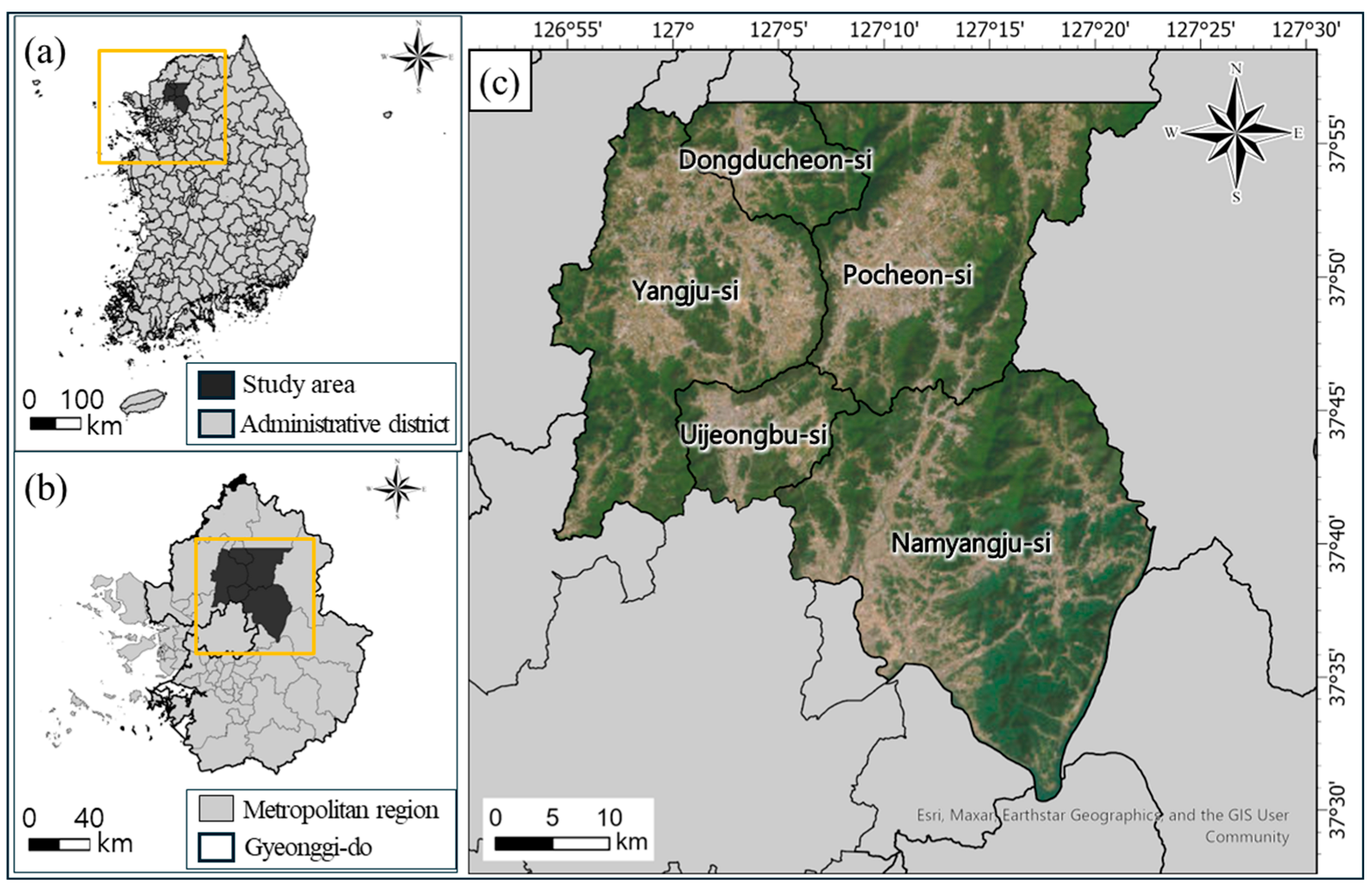



| Province | Area (km2) | Major Crops | Cultivation Area (%) | Main Growth Season (Month) |
|---|---|---|---|---|
| Dongducheon-si | 95.67 | Perilla | 39.02 | 6–9 |
| Young Summer Radish | Multiple crops | |||
| Namyangju-si | 458.13 | Perilla | 16.19 | 6–9 |
| Spinach | Multiple crops | |||
| Pocheon-si | 827.23 | Rice | 39.55 | 5–8 |
| Spinach | Multiple crops | |||
| Uijeongbu-si | 81.55 | Rice | 28.14 | 5–8 |
| Perilla | 6–9 | |||
| Yangju-si | 310.49 | Rice | 46.63 | 5–8 |
| Perilla | 6–9 |
| Class | Overall Accuracy | |||||
|---|---|---|---|---|---|---|
| Rice paddy | 0.84 | 0.90 | 0.80 | 0.85 | 0.82 | 0.71 |
| Upland field | 0.82 | 0.88 | 0.85 | 0.88 | ||
| Abandoned cropland | 0.54 | 0.94 | 0.69 | 0.84 |
Disclaimer/Publisher’s Note: The statements, opinions and data contained in all publications are solely those of the individual author(s) and contributor(s) and not of MDPI and/or the editor(s). MDPI and/or the editor(s) disclaim responsibility for any injury to people or property resulting from any ideas, methods, instructions or products referred to in the content. |
© 2025 by the authors. Licensee MDPI, Basel, Switzerland. This article is an open access article distributed under the terms and conditions of the Creative Commons Attribution (CC BY) license (https://creativecommons.org/licenses/by/4.0/).
Share and Cite
Park, S.; Kang, S.; Hwang, B.; Ko, D.W. Detecting Abandoned Cropland in Monsoon-Influenced Regions Using HLS Imagery and Interpretable Machine Learning. Agronomy 2025, 15, 2702. https://doi.org/10.3390/agronomy15122702
Park S, Kang S, Hwang B, Ko DW. Detecting Abandoned Cropland in Monsoon-Influenced Regions Using HLS Imagery and Interpretable Machine Learning. Agronomy. 2025; 15(12):2702. https://doi.org/10.3390/agronomy15122702
Chicago/Turabian StylePark, Sinyoung, Sanae Kang, Byungmook Hwang, and Dongwook W. Ko. 2025. "Detecting Abandoned Cropland in Monsoon-Influenced Regions Using HLS Imagery and Interpretable Machine Learning" Agronomy 15, no. 12: 2702. https://doi.org/10.3390/agronomy15122702
APA StylePark, S., Kang, S., Hwang, B., & Ko, D. W. (2025). Detecting Abandoned Cropland in Monsoon-Influenced Regions Using HLS Imagery and Interpretable Machine Learning. Agronomy, 15(12), 2702. https://doi.org/10.3390/agronomy15122702


