Article

Water Uptake Characteristics of Stipa bungeana Trin: Affected by Subsidence in the Coal Mining Areas of Northwest China

1
State Key Laboratory of Water Resource Protection and Utilization in Coal Mining, CHN Energy Shendong Coal Group Co., Ltd., Beijing 100011, China
2
National Institute of Clean-and-Low-Carbon Energy, Beijing 102211, China
3
Key Laboratory of Agricultural Soil and Water Engineering in Arid and Semiarid Areas, Ministry of Education, Northwest A&F University, Xianyang 712100, China
4
School of Water and Environment, Chang’an University, Xi’an 710054, China
5
Department of Irrigation and Water Management, Bangladesh Agricultural University, Mymensingh 2202, Bangladesh
*
Authors to whom correspondence should be addressed.
Agronomy 2024, 14(3), 424; https://doi.org/10.3390/agronomy14030424
Submission received: 1 February 2024 / Revised: 19 February 2024 / Accepted: 21 February 2024 / Published: 22 February 2024
(This article belongs to the Section Agricultural Biosystem and Biological Engineering)

Abstract

:
Revealing the water use pattern of plants influenced by coal-mining-caused land subsidence is crucial to understand plant–water interactions and guide ecological restoration. However, available information on herbaceous plants, the dominant species in most arid and semi-arid regions with abundant coal resources, remains inadequate. We investigated the water use patterns of Stipa bungeana Trin. by measuring soil water content, root distribution, and stable isotopes of hydrogen (δ2H) and oxygen (δ18O) of soil water and plant stem water both before and after a rainfall event. The results revealed that prior to rainfall, both areas exhibited a low soil water content with no discernible difference in soil drought. However, the soil waters δ2H and δ18O were found to be more enriched at varying depths within the subsidence area, indicating a heightened level of soil evaporation. Both soil water content and soil water isotopic composition responded sensitively to rainfall, with rainfall primarily replenishing the shallow layer (0–20 cm), thereby reflecting an infiltration mode dominated by piston flow. More water seeped into deeper soil layers in the subsidence area compared to the non-subsidence area, with more preferential flow. Before rainfall, the sources of plant water uptake were consistent both at shallow and deep soil layers, implying that the proportion of water uptake gradually decreased with increasing depth. After rainfall, the sources of plant water uptake differed slightly between the two soil layers. The plants in non-subsidence and subsidence areas dominantly extracted soil water at depths greater than 10 cm and 20 cm, respectively. The root system in the subsidence area was more developed than that in the non-subsidence area. Plant water uptake was primarily influenced by the spatial distribution of roots, as well as the post-rainfall water distribution, regardless of whether they were in the subsidence area or not. Although land subsidence affected soil water transport, the water uptake pattern of Stipa bungeana Trin. was similar before and after rainfall, indicating the adaptive growth of plants through their roots in the subsidence area. The high adaptability of herbs such as Stipa bungeana Trin. makes them a viable option for vegetation restoration in subsidence areas. This study has significant implications for evaluating plant–water relationships in subsidence areas due to coal mining, thereby providing a fundamental basis and valuable reference for ecological restoration and management strategies within such affected regions.

1. Introduction

Coal is the main energy source in many countries, constituting over 20% of global primary energy consumption and playing an important role in social and economic development [1]. Underground mining is an effective and the main way to extract coal resources, with the advantages of high mining efficiency, safe operation, and low visual impact [2]. However, underground mining results in a large number of underground mined-out areas, inevitably causing land subsidence and altering the original structure of the vadose zone [3,4]. The land area affected by subsidence currently spans 700,000 km2 and exhibits a consistent annual increase of 130 km2 [4]. Soil properties, including bulk density, texture, and nutrients, undergo corresponding changes, as well as hydrological processes such as infiltration, runoff, and evaporation [5]. As a result, land subsidence due to coal mining leads to a series of ecological problems, especially the degradation of vegetation, which causes the serious deterioration of the environment of the mining area, with a consequent effect on social stability [6,7]. These problems are particularly acute in arid and semi-arid mining areas, where ecosystems are already unstable [8,9]. Therefore, minimizing the ecological impact of land subsidence and implementing land reclamation and vegetation restoration are essential objectives for all stakeholders, while simultaneously ensuring sustainable coal energy production.
Plants, being a key component of the ecosystem, acquire water and nutrients for growth, metabolism, and other physiological activities through root uptake [10]. Therefore, understanding the water uptake strategies of plant roots is crucial for the effective and sustainable cultivation management of plants in the changing world of increased extreme weather and human impacts. For instance, investigating root water uptake patterns in plantations with varying stand ages provide novel insights into subsequent management practices [9,11]. Research on the root water absorption of various crops and orchard trees provided a theoretical basis for precise and water-saving irrigation in agriculture [12,13]. Furthermore, comparative studies on the water uptake strategies of different vegetation in arid/semi-arid regions have offered valuable insights for selecting vegetation species for ecological restoration purposes [14]. The subsidence of coal mining has significantly changed the hydrological and pedological conditions, as well as the root systems of plants in the region [4], thereby impacting vegetation maintenance. Consequently, it is necessary to determine the water use patterns of plants disturbed by land subsidence due to coal mining, which is important for understanding the plant–water relationship and guiding the ecological restoration of the subsidence areas. Currently, it is typically challenging to directly measure the soil–plant–water potential with the available methods used in root water uptake studies, particularly when plants rely on both groundwater and surface water sources alongside antecedent soil water [15]. Challenges also arise due to the necessity of the destructive sampling of plants for obtaining the basic data needed for simulating root water uptake [16,17].
Stable isotopes of hydrogen (2H) and oxygen (18O), as basic components of water molecules, are ideal tracers widely used to elucidate the origin of water [18,19]. Using an isotopic method for tracing the source of water absorbed by plants through their root systems has several advantages: it requires only a minimal number of samples for analysis, causes low damage to plants or soil, and yields reliable outcomes [20,21]. Therefore, stable hydrogen and oxygen isotopes have been extensively used as highly effective tools to identify and quantify the relative contribution of different water sources to plant–water uptake [22,23]. To date, only a few studies have employed stable isotopes to explore the effect of coal-mining-caused land subsidence on plant root water uptake. For example, Chen et al. [24] observed alterations in the water uptake pattern of Artemisia Desertorum due to subsidence, while Li et al. [7] reported the widespread effects of coal-mining-induced subsidence on groundwater uptake by plant species. However, current studies have primarily focused on tree and shrub species, with a lack of exploration into herbaceous plants. Although herbaceous plants are dominant species in arid and semi-arid areas, their root water absorption patterns are usually different from those of tree and shrub species [25,26].
To bridge the gap, using Stipa bungeana Trin. as a representative herbaceous plant, which is widely distributed in mining areas of Northwest China [27], this study explored the impact of coal-mining-caused land subsidence on the root water uptake of Stipa bungeana Trin. and the response of root water uptake to rainfall using isotopic techniques. The objectives of this study were: (1) to investigate the effects of land subsidence due to coal mining on soil water transport and (2) to compare the water uptake pattern of Stipa bungeana Trin. in subsidence and non-subsidence areas. This study identified plant–water relationships in the coal-mining-caused subsidence area that are fundamental to ecological restoration and management.

2. Materials and Methods
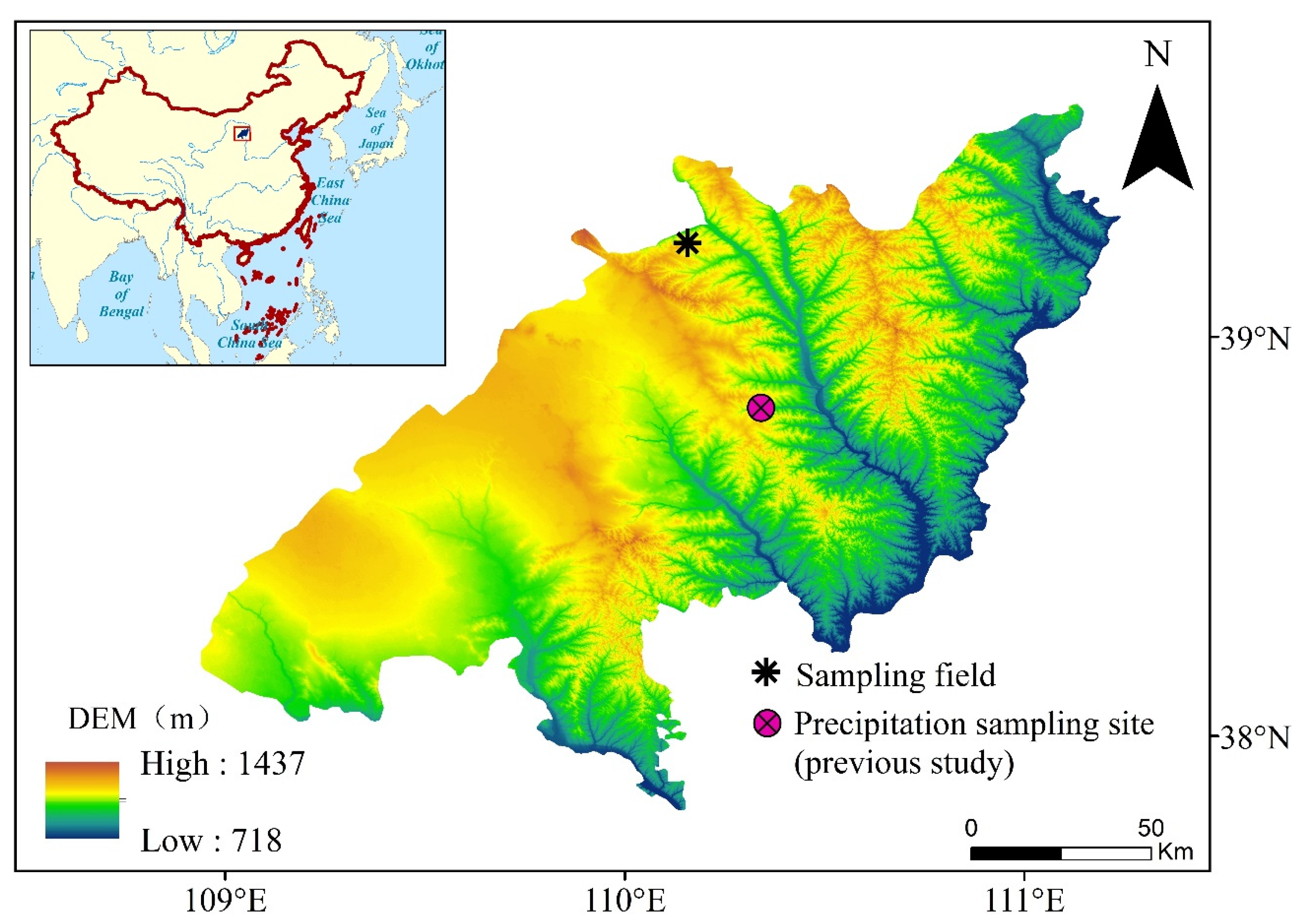
2.1. Study Site

The experimental field (110.15° E, 39.23° N) belongs to the Huojitu coal mine of Yushenfu mining area, which is located at the border of Mu Us Desert and Loess Plateau of northern Shaanxi Province, China (Figure 1). The mining area experiences a continental monsoon climate typical of arid and semi-arid regions, characterized by an annual average rainfall ranging from 318 to 485 mm and evaporation rates between 1700 and 2500 mm, thereby forming a dry and delicate environmental setting [8,28]. The soil texture in this area is predominantly sandy with a bulk density of 1.59 g cm−3. Due to water scarcity, the native vegetation is dominated by grasslands, including Stipa bungeana Trin., Leymus secalinus (Georgi) Tzvel, Astragalus sinicus L., Ferula bungeana Kitagawa, Artemisia capillaris Thunb., and Poa sphondylodes Trin. [27]. We selected one flat plot of land covered by Stipa bungeana Trin. in the subsidence area of coal mining and another flat plot of land in the non-subsidence area within the coal mine. The growth pattern exhibited by Stipa bungeana Trin. was comparable between the two plots. Notably, the subsidence area was in a stable state with no new cracks formed, and no further subsidence has occurred in recent years.

2.2. Rainfall, Plant, and Soil Samples Collection

Soil and plant stem samples were collected from non-subsidence and subsidence areas on 1 July 2022 (pre-rainfall) and 3 July 2022 (post-rainfall). The last rainfall event prior to sampling occurred on 21 June 2022. During the study period, precipitation was recorded on 2 July 2022, amounting to a total of 9.6 mm. Rainwater samples were collected in a rain bucket placed in an open field from this specific rainfall event. Water samples were collected from the rain bucket into 50 mL plastic bottles immediately after the rainfall. The bottles were packed and sealed with Parafilm to prevent the evaporation loss of water and then stored in a refrigerator at 4 °C for subsequent isotope analysis in the laboratory.
Stipa bungeana Trin. with healthy growth was selected as the experimental plant from each experimental plot for sample collection. Three repeated samples were collected at three different locations in each experimental plot. Since Stipa bungeana Trin. lacks xylem, thick stem samples (representing the rhizome-binding component) were collected for plant water isotope analysis. After removing surface impurities, the sampled stems were immediately placed into 12 mL bottles (Exetainers, Labco Ltd., Lampeter, UK), tightly sealed with Parafilm, and stored in a refrigerator for isotopic analysis.
For soil sampling, a nearby location was selected on the soil surface for stem sampling, resulting in three parallel profiles per experimental plot. Each location was drilled a profile to a depth of 100 cm, with a 10 cm interval at the top, 20 cm depth, and 20 cm interval for the rest of the 80 cm underneath. The soil sample collected from each sampling layer was split into two parts: one part was placed into an aluminum box for laboratory analysis, which was oven-dried at 105 °C for 24 h to obtain the gravimetric soil water content, and the remaining part was packed into a 100 mL plastic bottle sealed with Parafilm and refrigerated for isotopic analysis.

2.3. Root Sampling and Analysis

Root samples, mixed with soil, were collected using a hand auger (85 mm inner diameter) at depth intervals consistent with the above soil sampling depths. This process was repeated in the three locations mentioned above. The soil-mixed root samples were sieved through 1 mm mesh and washed with tap water. The clean roots were collected with tweezers and then scanned at 300 dpi and analyzed using WinRHIZO Pro 2016 image analysis software (Regent Instruments, Quebec, QC, Canada) to determine root length. Root length density (RLD) was calculated by dividing root length (Lroot) by soil core volume (Vsoil):
R L D = L r o o t V s o i l
where Lroot is the output of WinRHIZO software in cm, and Vsoil is the sampled soil volume in cm3. Then, the roots were oven-dried at 65 °C for 72 h until reaching a constant weight. Finally, the root mass density (RMD) was determined by dividing root mass (Mroot) by Vsoil:
R M D = M r o o t V s o i l
where Mroot is the weight of the dried root in g.

2.4. Isotopic Analysis of Water

Water from the soil and stem samples was extracted using a vacuum condensation extraction system. A 12 mL bottle (Exetainers, Labco Ltd., Lampeter, UK) containing the soil or stem sample was inserted into a customized heating module that was immersed in high-temperature silicone oil. A water collection bottle (Exetainers, Labco Ltd., Lampeter, UK) was immersed in liquid nitrogen and connected to the sample-containing bottle through a 1.5 mm stainless steel needle. The heating temperature of 205 °C for the soil sample and 105 °C for the stem sample was maintained at a vacuum pressure below 1 Pa. The extraction time of the water was ≥0.5 h for soil samples and 3 h for stem samples, ensuring that the water recovery rate was maintained between 98% and 102%.
The hydrogen and oxygen isotopes of rainwater and extracted soil water were analyzed using an off-axis integrated cavity output spectroscopy water isotope analyzer (LWA-45EP, Los Gatos Research, Los Gatos, CA, USA). To prevent organic contamination introduced by the plant stem water, an isotope ratio mass spectrometer (IRMS 253 Plus, Thermo Fisher Scientific Inc., Bremen, Germany) was used to analyze the isotopic compositions of the stem water. The measured δ2H and δ18O are expressed as the difference (δ) relative to Vienna Standard Mean Ocean Water (V-SMOW):
δ = R s a m p l e R V - S M O W R V - S M O W
where Rsample and RV-SMOW are the ratios of 2H/1H or 18O/16O in water samples and standard samples, respectively. The accuracy of the measurement is ±1‰ for δ2H and ±0.2‰ for δ18O.

2.5. Data Analysis

The MixSIAR model, an R-script of Bayesian model framework, is a highly effective and proficient tool for determining the relative contribution of various sources of plant water uptake based on stable isotopes [30]. Since the groundwater level in the study area is deeper than the maximum rooting depth of plants, soil water can be considered to be the sole source of water uptake by roots. The raw δ2H and δ18O values of both plant and soil water were used as the mixture data input to ‘MixSIAR’, and the discriminant data were set to zero due to the absence of isotopic fractionation during plant–water uptake [31,32]. The execution time of the Markov MonteCarlo chain was set as “very long”, and the error structure was set to be “Resid*Process”. Gelman-Rubin and Geweke were used to check the convergence of the model execution.
A one-way analysis of variance (ANOVA) was used to analyze the differences in soil water content, root length density, and root mass density between the subsidence area of coal mining and the non-subsidence area. Pearson’s correlation analysis was conducted to identify the contributions of different water sources between soil water content, root length density, and root mass density. All statistical analyses were performed using SPSS 25.0 (SPSS Inc., Chicago, IL, USA) with a significance level at 0.05 or 0.01 in some cases.

3. Results

3.1. Soil Water Contents as Affected by Rainfall

The soil water contents varied slightly in non-subsidence and subsidence areas with depth before rainfall, fluctuating by about 0.02 cm3 cm−3 (Figure 2a). The distribution of soil water did not differ significantly (p > 0.05) between the two areas. After rainfall, the soil water content within the 0–100 cm soil profile varied from 0.03 cm3 cm−3 to 0.15 cm3 cm−3 in the non-subsidence area and 0.05 cm3 cm−3 to 0.18 cm3 cm−3 for the subsidence area (Figure 2b). For each area, the soil water content in the surface layer (within 20 cm depth) exhibited the most increase as a result of rainfall, with a comparatively smaller rate of increase observed in deeper layers when compared to shallower layers. Although there was no significant difference in soil water contents between the two areas, rainfall induced greater infiltration in the subsidence area, penetrating to deeper layers compared to the non-subsidence area (Figure 2c).

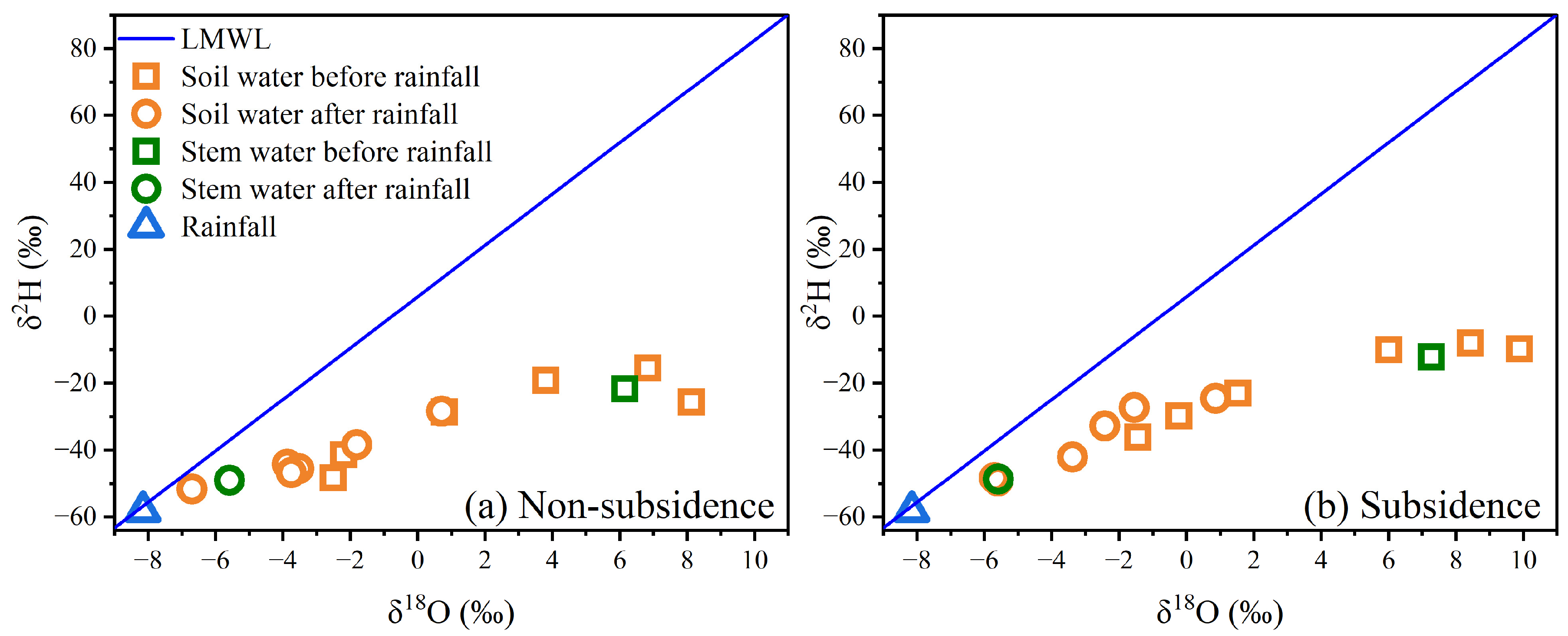
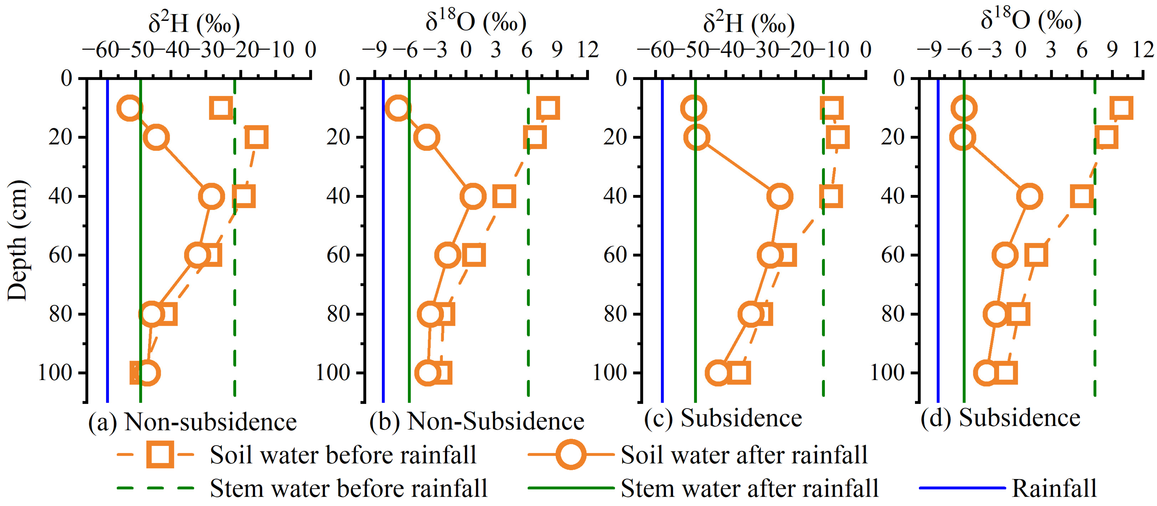
3.2. Isotopic Composition of Water in Plant Stem and Soil

The stable isotopes of soil water below the local meteoric water line (LMWL: δ2H = 7.67 δ18O + 5.91, R2 = 0.96 [29]) were observed both before and after the rainfall event in both subsidence and non-subsidence areas (Figure 3), revealing that soil water originated from rainfall and underwent evaporation enrichment. There was a considerable overlap of stem and soil water isotopic values at both areas and before and after rainfall in the dual isotope space, indicating soil water as the main source of water for uptake by Stipa bungeana Trin. (Figure 3). After rainfall, the isotopic composition of plant water and soil water exhibited a convergence towards that of precipitation, indicating a rapid response from both soil and plants to precipitation events.
Before rainfall, the δ2H and δ18O values of the soil water in the non-subsidence area were in the range of –15.4‰ to –48.3‰ and 8.1‰ to –2.5‰, respectively, with a depleting trend from shallow to deep layers (Figure 4a,b). The trend of the variation in δ2H and δ18O of the subsidence area also revealed a similar distribution as that in the non-subsidence area, showing –7.9‰ to –36.1‰ for δ2H and 9.9‰ to –1.5‰ for δ18O (Figure 4c,d). However, in comparison to the non-subsidence area, the soil water isotopic values in the subsidence area showed a noticeable enrichment, as did the corresponding stem water isotopic values. This observation reflects a heightened intensity of soil evaporation within the subsidence area. After rainfall, the soil water isotopes varied from –28.3‰ to –51.7‰ for δ2H and 0.7‰ to –6.7‰ for δ18O in the non-subsidence area, and from –24.5‰ to –49.2‰ for δ2H and –0.9‰ to –5.7‰ for δ18O in the subsidence area (Figure 4). The isotopic values of the soil water had an initial increase followed by a subsequent decrease with increasing soil depth, indicating the response of rainfall to infiltration and recharge.
The variation in δ2H and δ18O before and after rainfall is further compared in Figure 5. The Δδ2H and Δδ18O values in the surface layer (within top 20 cm) were greater than those in the deeper layer (below 20 cm) both for non-subsidence and subsidence areas. Moreover, compared to the non-subsidence area, the Δδ2H and Δδ18O values in the subsidence area were larger in the soil profile (Figure 5). To sum up, rainfall mainly replenished soil water in the surface layer, and infiltration was larger in the subsidence area than in the non-subsidence area.

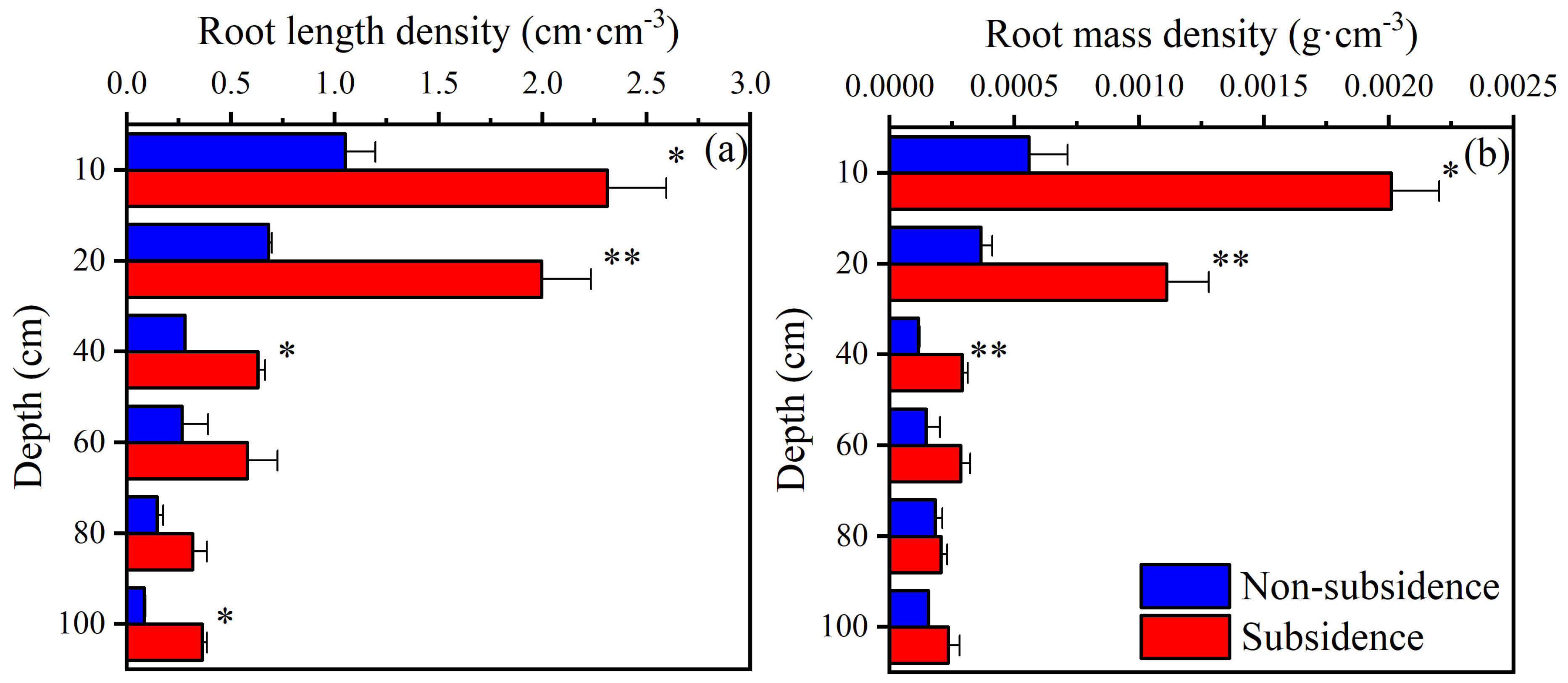
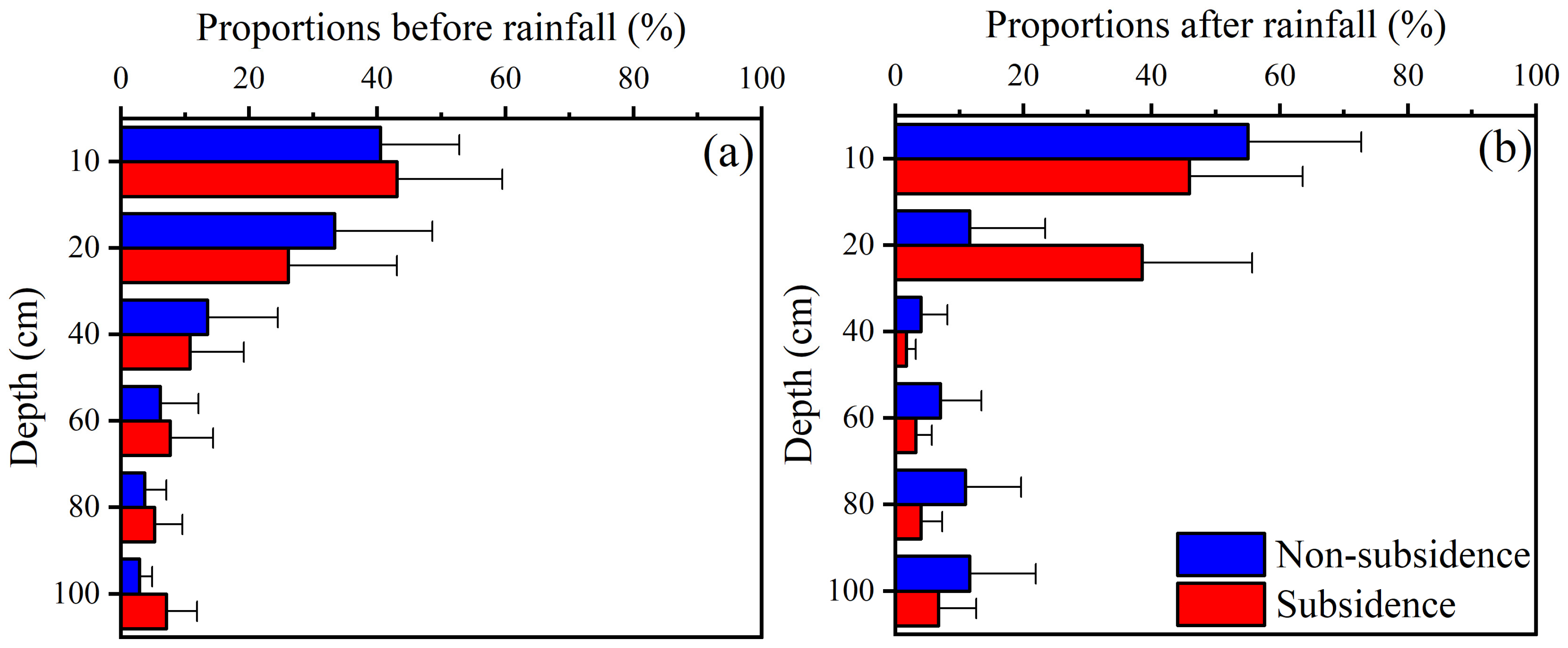
3.3. Root Distribution and Water Uptake Pattern

The roots of Stipa bungeana Trin. in non-subsidence and subsidence areas decreased with increasing depth, and most of the roots were predominantly distributed within the 0–20 cm soil layer, accounting for 69.2% and 69.5% of the total root length and 60.7% and 75.5% of the total root mass in the corresponding area (Figure 6). The root system was more developed in the subsidence area compared to the non-subsidence area, especially in the 0–40 cm soil layer, and the root length and root mass density were significantly increased (p < 0.05) (Figure 6).
The intersection of soil water and stem water isotopes can be used to identify water sources from where plants have absorbed water. Before rainfall, the stem water and soil water of Stipa bungeana Trin. in non-subsidence (Figure 4a) and subsidence (Figure 4b) areas intersected at about 40 cm depth, indicating that land subsidence did not change the water uptake horizon of plants under drought conditions. After rainfall, the intersection points of the stem water and soil water of Stipa bungeana Trin. in non-subsidence (Figure 4c) and subsidence (Figure 4d) areas shifted to the surface layer, which were 0–10 cm and 0–20 cm, respectively, for the two areas. This observation demonstrates that, under the influence of rainfall, the plant water absorption zone shifted to the shallow soil depth, but the degree of shifting was smaller in the subsidence area compared to the non-subsidence area.
To quantitatively evaluate plant water uptake, the MixSIAR model was used to estimate the contribution of the water source at the two areas on different sampling dates (Figure 7). Before rainfall, the proportion of water absorbed by the plants decreased with the increasing depth of the soil, accounting for 40.5 ± 12.3%, 33.3 ± 15.3%, 13.5 ± 11.0%, 6.1 ± 6.0%, 3.7 ± 3.4%, and 2.9 ± 2.0% for the non-subsidence area and 43.1 ± 16.4%, 26.1 ± 17.0%, 10.8 ± 8.4%, 7.7 ± 6.7%, 5.2 ± 4.4%, and 7.1 ± 4.8% for the subsidence area at different depths (Figure 7a). Under the dry soil condition before rainfall, the contribution of the water source to Stipa bungeana Trin. did not change with subsidence. But, after rainfall, the root water uptake by Stipa bungeana Trin. changed, accounting for 55.0 ± 17.7%, 11.6 ± 11.8%, 4.0 ± 4.1%, 7.0 ± 6.4%, 10.9 ± 8.7%, and 11.6 ± 10.3% for the non-subsidence area and 45.9 ± 17.7%, 38.5 ± 17.2%, 1.7 ± 1.5%, 3.2 ± 2.5%, 4.0 ± 3.3%, and 6.7 ± 5.9% for the subsidence area in different soil layers (Figure 7b). The water sources for plant uptake differed between the two areas; plants predominantly utilized soil water from the 0 to 10 cm soil profile in the non-subsidence area, whereas they relied on water from the 0 to 20 cm soil profile in the subsidence area. However, the differences in the water absorption sources of plants across different regions exhibit negligible significance according to the MixSIAR model calculations.

3.4. Relationship between Water Uptake Pattern and Root and Water Distribution

The root system and soil water distribution are pivotal factors governing the source of plant water uptake. In non-subsidence areas, the contributions of water sources in different soil layers showed a significantly positive correlation with root distribution, including RLD and RMD at any time. Additionally, it is significantly and positively correlated with soil water content after rainfall (Table 1). Similarly, the contributions of the water sources of different soil layers in subsidence areas exhibited a significantly positive correlation with root distribution (RLD and RMD) at any given time. However, it exhibits a significant negative correlation with soil moisture prior to rainfall and a significant positive correlation after rainfall in subsidence areas (Table 1). Notably, the observed negative correlation between the water uptake pattern and SWC before rainfall appeared to be inconclusive as it contradicted the fundamental principle that plants tend to absorb more water in areas with a higher SWC. In general, regardless of subsidence occurrence, plant water uptake was exclusively determined by root distribution, with a higher rate observed in the presence of more roots. Following rainfall, it was also influenced by soil water distribution, resulting in an increased water uptake rate when the water supply was sufficient.

4. Discussion

4.1. Soil Water Transport as Affected by Coal-Mining-Caused Land Subsidence

Infiltration and evaporation are the key components of soil water transport that depend on soil properties and climatic conditions [33]. Before rainfall, the soil water content was very low, and its distribution over the depth of the soil was not significantly different between subsidence and non-subsidence areas (Figure 2a), but soil water isotopes (δ2H and δ18O) were more enriched in the subsidence area (Figure 4a,b). In the study area, the arid climate and high evaporation rate caused the soil water supplied by rainfall to be consumed in a short time period [34,35]. Therefore, in the event of prolonged drought, the soil water content was very low and did not change in each layer and exhibited negligible variations between subsidence and non-subsidence regions. Furthermore, as constituents of water molecules, stable isotopes of hydrogen and oxygen are highly sensitive to environmental fluctuations and encapsulate comprehensive information regarding all the physical processes undergone by water [36]. Therefore, the progressive attenuation of stable isotopes in soil water with increasing depth prior to precipitation reflects surface evaporation, which is also a characteristic profile attribute of stable isotopes in soil water during drought conditions, as evaporation intensity diminishes with soil depth [37,38,39]. The partial enrichment of isotopes in the subsidence area is most likely indicative of stronger soil evaporation since land subsidence destroys the soil structure [1,3]. Previous studies have also found that the soil evaporation rate in subsidence areas is much greater than that in non-subsidence areas [40,41].
The water content (Figure 2) and water stable isotopic composition (Figure 5) of soil showed clear responses to rainfall, indicating the replenishment of soil water by precipitation. Compared with the soil water enriched by evaporation, the stable isotope composition of precipitation is obviously depleted, and the change in the stable isotope profile of soil water after a rainfall event can be used as a reliable indicator to determine the main infiltration area [42,43]. With the mixing of precipitation and soil water, the enriched soil water stable isotopic composition tends to be depleted. Therefore, the peak of soil water isotopes at 40 cm (Figure 4) indicates that the main recharge depth of precipitation is in shallow soil. This can also be illustrated by the major regions of variation in the soil water content (Figure 2c). Both macroscopic changes in water content and microscopic changes in water molecules indicate slow water movement, which reflects a dominant piston flow mode for the water supply in both subsidence and non-subsidence areas, as inferred from our findings. Several studies have also confirmed that, in homogeneous soils, soil water recharge occurs mainly through piston flow, except for some limited areas, such as soil crevices and biological pores [44,45,46]. Moreover, this may be associated with the limited precipitation amount, as previous studies have indicated that preferential flow is more prone to occur during intense rainfall events [45,47]. Nonetheless, in terms of soil water content and stable isotopes, our results also showed that more water permeated deeper layers of soil within subsidence areas (Figure 2c and Figure 5). The subsidence area exhibits collapsed fissures and loose soil resulting from the disruption of soil structure caused by mining activities [48,49]. Therefore, compared with undisturbed conditions in the non-subsidence area, water is more likely to penetrate and form preferential flow recharge in the subsidence area.

4.2. Root Water Uptake Pattern Affected by Subsidence

The hydrological process of the original soil has been greatly altered in the subsidence area, and understanding the modifications in plants’ water uptake can contribute to ecosystem restoration and management. Before the occurrence of rainfall, the proportions of plant water uptake from different sources in the subsidence and non-subsidence areas remained consistent with a decreasing trend with increasing depth (Figure 7a). The uptake of water by plants is driven by a potential difference, as they selectively extract water with lower energy consumption [50]. Meanwhile, in the pre-rain state, the root zone soil of the two areas was in the drought condition, and the soil water potentials at different depths were almost invariant (Figure 2a). Therefore, Stipa bungeana Trin. extracts a greater amount of water from shallow soil layers in order to regulate its energy demand, and the water uptake exhibits a significantly positive correlation with root distribution (Table 1). After the occurrence of rainfall, the soil layer for the main plant water uptake quickly shifted to the soil water recharge layer (Figure 7b). Therefore, root water uptake is related to not only root distribution but also the soil water content in subsidence and non-subsidence areas (Table 1). A number of studies have also shown that most plants shift their water uptake patterns to preferentially use shallow soil water that is replenished by rainfall [28,50,51]. In addition, the soil layer for main water uptake by Stipa bungeana Trin. In the subsidence area was slightly deeper than in the non-subsidence area (Figure 7b) due to the impact of subsidence on soil water transport. This phenomenon has also been reported in a previous study of changes in the water uptake of Artemisia desertorum affected by coal-mining-caused land subsidence [24]. Although the primary depth of water absorption by plants following rainfall was marginally greater in the subsidence area compared to the non-subsidence area, overall, plant response to the rainfall-induced water supply was predominantly observed within the 0–20 cm soil layer. In conjunction with the non-differential sources of plant water uptake prior to precipitation, it appears that coal-mining-induced land subsidence has not directly impacted the water uptake pattern of Stipa bungeana Trin.
The correlation analysis revealed that the water uptake pattern was primarily attributed to the distribution of RLD and RMD (Table 1). Consequently, the water absorption pattern of plant can not directly reflect the subsidence effect, which can be associated with the characteristics of the root system. The more developed root systems, including RLD and RWD, observed in the subsidence area, as compared to those in the non-subsidence area (Figure 6), unequivocally demonstrate that Stipa bungeana Trin. effectively withstands subsidence through robust root growth. The roots of herbaceous plants have outstanding environmental adaptability [26]. Herbs possess the inherent ability to modify their morphological structure in order to effectively adapt to dynamic and intricate water and soil resource environments, thereby optimizing their patterns of water utilization [52]. However, the more developed root in the subsidence area obtained in the 0–40 cm soil layer was not consistent with previous studies [53]. This phenomenon may be attributed to the unique natural conditions of the study region, where rainfall fails to adequately replenish water in the deep soil layer, thereby limiting downward root growth and water absorption. Conversely, previous studies have highlighted the significance of surface condensation such as dew as a vital water source for plants in arid regions [54,55]. Consequently, shallow roots tend to develop in subsidence areas likely due to their ability to absorb this available moisture.

4.3. Implications for Ecological Restoration of Subsidence Area

Restoration of the ecology damaged by land subsidence is a shared concern in coal mining regions worldwide, with vegetation restoration being the primary imperative [4,10,56]. The comprehension of soil hydrological processes and plant water uptake characteristics in areas affected by coal-mining-induced land subsidence can provide crucial evidence to support the restoration and management of ecological systems. In this study, despite the subsidence-induced infiltration of rainfall into deeper soil layers, it was observed that the majority of the rainwater supply predominantly occurred within the 0–20 cm soil layer (Figure 2), which coincides with the primary region for plant water uptake (Figure 7). Furthermore, our findings indicate that subsidence did not significantly alter the depth of the soil layer utilized by Stipa bungeana Trin. for water absorption (Figure 7). Therefore, it is recommended to prioritize the shallow soil layer, which represents the pivotal region for plant water consumption, when implementing soil reconstruction or reclamation in areas affected by coal-mining-induced subsidence. Many engineering practices and studies also demonstrated that surface restoration is an effective method of ecological restoration [57,58]. Our findings further demonstrate that Stipa bungeana Trin. exhibits resilience against the detrimental impacts of coal-mining-induced land subsidence through adaptive modifications in its root system (Figure 6). Nevertheless, it is plausible that the adaptability and plasticity of plant roots may be predominantly observed in herbaceous species [26]. Moreover, the climate of the northwest coal mining region (study area) is dry, and it is difficult for trees with a high water consumption to survive [59,60,61]. Therefore, herbs like Stipa bungeana Trin. should be chosen for vegetation reconstruction to adapt to the changing and harsh environment.
However, it is imperative to acknowledge the limitations of this study due to our focus on a typical semi-arid sandy land in coal mining areas. It should be noted that soil properties vary significantly across different regions, such as the Loess Plateau [62]. Consequently, the generalizability of our findings may be influenced by variations in soil characteristics. In future research, we aim to explore how coal mining subsidence impacts plant water absorption sources across diverse soil types.

5. Conclusions

This study reveals the soil water transport and water use patterns of Stipa bungeana Trin. in non-subsidence and coal-mining-caused land subsidence areas. Before a rainfall event, the soil water content in different soil layers in both areas remained consistently low due to prolonged drought. However, the soil waters δ2H and δ18O were more enriched in the subsidence area compared to the non-subsidence area, indicating stronger evaporation. The soil water content and soil water isotopic composition in both areas responded sensitively to rainfall, which mainly recharged the shallow soil layer (0–20 cm). The soil water content and isotopic composition both indicate a piston flow mode of rainfall infiltration into the soil. However, more water seeped into deeper layers in the subsidence area compared to the non-subsidence area, indicating that there is more dominant flow. The sources of water for plants’ uptake were consistent in both areas before rainfall but differed slightly after rainfall; soil water was the dominant source below 10 cm depth in the non-subsidence area and below 20 cm in the subsidence area. Although land subsidence affected soil water transport, the water uptake patterns of the plants in different areas were similar both before and after rainfall due to the adaptive growth of the plant’s root system in the subsidence area. The selection of herbs such as Stipa bungeana Trin. is recommended for vegetation reconstruction in the coal mining region of Northwest China, enabling adaptation to dynamic and challenging environmental conditions. This study provides some novel insights into plant–water relationships in the subsidence area caused by coal mining and a basis and reference for the ecological restoration and management of the subsidence area.

Author Contributions

Conceptualization, S.C. and Y.Y.; methodology, Y.L. and H.W.; software, H.W.; validation, L.B., J.N. and Y.Y.; formal analysis, Y.L. and H.W.; investigation, Y.L. and H.W.; resources, S.C. and L.B.; data curation, M.L.; writing—original draft preparation, H.W.; writing—review and editing, M.A.M. and M.L.; visualization, H.W.; supervision, M.L. and Y.Y.; project administration, J.N. and M.L.; funding acquisition, J.N. and M.L. All authors have read and agreed to the published version of the manuscript.

Funding

This research was funded by Open Fund of State Key Laboratory of Water Resource Protection and Utilization in Coal Mining, grant number GJNY-20-113-16.

Data Availability Statement

Data are contained within the article.

Acknowledgments

Authors thank the technical help from Jingjing Jin and Min Wang, Institute of Water-saving Agriculture in Arid Areas of China, Northwest A&F University.

Conflicts of Interest

Authors Haoyan Wei, Yingming Yang and Min Li from CHN Energy Shendong Coal Group Co., Ltd. The remaining authors declare that the research was conducted in the absence of any commercial or finaical relationships that could be construed as a potential conflicts of interests.

References

  1. Kholod, N.; Evans, M.; Pilcher, R.C.; Roshchanka, V.; Ruiz, F.; Coté, M.; Collings, R. Global Methane Emissions from Coal Mining to Continue Growing Even with Declining Coal Production. J. Clean. Prod. 2020, 256, 120489. [Google Scholar] [CrossRef]
  2. Seguel, F.; Palacios-Játiva, P.; Azurdia-Meza, C.A.; Krommenacker, N.; Charpentier, P.; Soto, I. Underground Mine Positioning: A Review. IEEE Sens. J. 2022, 22, 4755–4771. [Google Scholar] [CrossRef]
  3. Dejun, Y.; Zhengfu, B.; Shaogang, L. Impact on Soil Physical Qualities by the Subsidence of Coal Mining: A Case Study in Western China. Environ. Earth Sci. 2016, 75, 652. [Google Scholar] [CrossRef]
  4. Wang, J.; Wang, P.; Qin, Q.; Wang, H. The Effects of Land Subsidence and Rehabilitation on Soil Hydraulic Properties in a Mining Area in the Loess Plateau of China. Catena 2017, 159, 51–59. [Google Scholar] [CrossRef]
  5. Yang, J.; Wei, H.; Quan, Z.; Xu, R.; Wang, Z.; He, H. A Global Meta-Analysis of Coal Mining Studies Provides Insights into the Hydrologic Cycle at Watershed Scale. J. Hydrol. 2023, 617, 129023. [Google Scholar] [CrossRef]
  6. Huang, Y.; Wang, J.; Li, J.; Lu, M.; Guo, Y.; Wu, L.; Wang, Q. Ecological and Environmental Damage Assessment of Water Resources Protection Mining in the Mining Area of Western China. Ecol. Indic. 2022, 139, 108938. [Google Scholar] [CrossRef]
  7. Li, W.; Yan, M.; Qingfeng, Z.; Xingchang, Z. Groundwater Use by Plants in a Semi-Arid Coal-Mining Area at the Mu Us Desert Frontier. Environ. Earth Sci. 2013, 69, 1015–1024. [Google Scholar] [CrossRef]
  8. He, Y.; He, X.; Liu, Z.; Zhao, S.; Bao, L.; Li, Q.; Yan, L. Coal Mine Subsidence Has Limited Impact on Plant Assemblages in an Arid and Semi-Arid Region of Northwestern China. Écoscience 2017, 24, 91–103. [Google Scholar] [CrossRef]
  9. Wu, W.; Tao, Z.; Chen, G.; Meng, T.; Li, Y.; Feng, H.; Si, B.; Manevski, K.; Andersen, M.N.; Siddique, K.H.M. Phenology Determines Water Use Strategies of Three Economic Tree Species in the Semi-Arid Loess Plateau of China. Agric. Forest Meteorol. 2022, 312, 108716. [Google Scholar] [CrossRef]
  10. Du, H.-D.; Cao, Y.-C.; Zhang, Y.-Y.; Ning, B.-Y. Plant Community Development in a Coal Mining Subsidence Area: Active versus Passive Revegetation. Écoscience 2021, 28, 185–197. [Google Scholar] [CrossRef]
  11. Tao, Z.; Li, H.; Si, B. Stand Age and Precipitation Affect Deep Soil Water Depletion of Economical Forest in the Loess Area. Agric. Forest Meteorol. 2021, 310, 108636. [Google Scholar] [CrossRef]
  12. Muñoz-Villers, L.E.; Geris, J.; Alvarado-Barrientos, M.S.; Holwerda, F.; Dawson, T. Coffee and Shade Trees Show Complementary Use of Soil Water in a Traditional Agroforestry Ecosystem. Hydrol. Earth Syst. Sci. 2020, 24, 1649–1668. [Google Scholar] [CrossRef]
  13. Zhang, Y.; Wu, S.; Kang, W.; Tian, Z. Multiple Sources Characteristics of Root Water Uptake of Crop under Oasis Farmlands in Hyper-Arid Regions. Agric. Water Manag. 2022, 271, 107814. [Google Scholar] [CrossRef]
  14. Cui, Y.; Pan, C.; Ma, L.; Sun, Z. Comparing Water Uptake Patterns of Two Tree Species Using Stable Isotopes on the Loess Plateau, China. Hydrol. Process. 2023, 37, e15006. [Google Scholar] [CrossRef]
  15. Nehemy, M.F.; Benettin, P.; Asadollahi, M.; Pratt, D.; Rinaldo, A.; McDonnell, J.J. Tree Water Deficit and Dynamic Source Water Partitioning. Hydrol. Process. 2021, 35, e14004. [Google Scholar] [CrossRef]
  16. Bechmann, M.; Schneider, C.; Carminati, A.; Vetterlein, D.; Attinger, S.; Hildebrandt, A. Effect of Parameter Choice in Root Water Uptake Models—The Arrangement of Root Hydraulic Properties within the Root Architecture Affects Dynamics and Efficiency of Root Water Uptake. Hydrol. Earth Syst. Sci. 2014, 18, 4189–4206. [Google Scholar] [CrossRef]
  17. Teodosio, B.; Pauwels, V.R.N.; Loheide II, S.P.; Daly, E. Relationship between Root Water Uptake and Soil Respiration: A Modeling Perspective. J. Geophys. Res.-Biogeosci. 2017, 122, 1954–1968. [Google Scholar] [CrossRef]
  18. Lu, Y.; Wen, M.; Li, P.; Liang, J.; Wei, H.; Li, M. An Improved Craig–Gordon Isotopic Model: Accounting for Transpiration Effects on the Isotopic Composition of Residual Water during Evapotranspiration. Agronomy 2023, 13, 1531. [Google Scholar] [CrossRef]
  19. Wei, H.; Wang, J.; Li, M.; Wen, M.; Lu, Y. Assessing the Applicability of Mainstream Global Isoscapes for Predicting δ18O, δ2H, and d-Excess in Precipitation across China. Water 2023, 15, 3181. [Google Scholar] [CrossRef]
  20. Huo, G.; Zhao, X.; Gao, X.; Wang, S. Seasonal Effects of Intercropping on Tree Water Use Strategies in Semiarid Plantations: Evidence from Natural and Labelling Stable Isotopes. Plant Soil 2020, 453, 229–243. [Google Scholar] [CrossRef]
  21. Tao, Z.; Neil, E.; Si, B. Determining Deep Root Water Uptake Patterns with Tree Age in the Chinese Loess Area. Agric. Water Manag. 2021, 249, 106810. [Google Scholar] [CrossRef]
  22. Marx, C.; Tetzlaff, D.; Hinkelmann, R.; Soulsby, C. Seasonal Variations in Soil–Plant Interactions in Contrasting Urban Green Spaces: Insights from Water Stable Isotopes. J. Hydrol. 2022, 612, 127998. [Google Scholar] [CrossRef]
  23. Rothfuss, Y.; Javaux, M. Reviews and Syntheses: Isotopic Approaches to Quantify Root Water Uptake: A Review and Comparison of Methods. Biogeosciences 2017, 14, 2199–2224. [Google Scholar] [CrossRef]
  24. Chen, G.; Guo, J.; Song, Z.; Feng, H.; Chen, S.; Li, M. Soil Water Transport and Plant Water Use Patterns in Subsidence Fracture Zone Due to Coal Mining Using Isotopic Labeling. Environ. Earth Sci. 2022, 81, 310. [Google Scholar] [CrossRef]
  25. Qianwen, G.; Arif, M.; Zhongxun, Y.; Jie, Z.; Xinrui, H.; Dongdong, D.; Fan, Y.; Changxiao, L. Plant Species Composition and Diversity along Successional Gradients in Arid and Semi-Arid Regions of China. Forest Ecol. Manag. 2022, 524, 120542. [Google Scholar] [CrossRef]
  26. Ward, D.; Wiegand, K.; Getzin, S. Walter’s Two-Layer Hypothesis Revisited: Back to the Roots! Oecologia 2013, 172, 617–630. [Google Scholar] [CrossRef] [PubMed]
  27. Mi, J.; Hou, H.; Zhang, S.; Hua, Y.; Yang, Y.; Zhu, Y.; Ding, Z. Detecting Long-Term Effects of Mining-Induced Ground Deformation on Plant Succession in Semi-Arid Areas Using a Cellular Automata Model. Ecol. Indic. 2023, 151, 110290. [Google Scholar] [CrossRef]
  28. Pei, Y.; Huang, L.; Shao, M.; Zhang, Y.; Pan, Y. Water Use Pattern and Transpiration of Mongolian Pine Plantations in Relation to Stand Age on Northern Loess Plateau of China. Agric. Forest Meteorol. 2023, 330, 109320. [Google Scholar] [CrossRef]
  29. Zhao, Y.; Dai, J.; Tang, Y.; Wang, L. Illuminating Isotopic Offset between Bulk Soil Water and Xylem Water under Different Soil Water Conditions. Agric. Forest Meteorol. 2022, 325, 109150. [Google Scholar] [CrossRef]
  30. Wang, J.; Lu, N.; Fu, B. Inter-Comparison of Stable Isotope Mixing Models for Determining Plant Water Source Partitioning. Sci. Total Environ. 2019, 666, 685–693. [Google Scholar] [CrossRef]
  31. Barbeta, A.; Burlett, R.; Martín-Gómez, P.; Fréjaville, B.; Devert, N.; Wingate, L.; Domec, J.-C.; Ogée, J. Evidence for Distinct Isotopic Compositions of Sap and Tissue Water in Tree Stems: Consequences for Plant Water Source Identification. New Phytol. 2022, 233, 1121–1132. [Google Scholar] [CrossRef] [PubMed]
  32. Parnell, A.C.; Phillips, D.L.; Bearhop, S.; Semmens, B.X.; Ward, E.J.; Moore, J.W.; Jackson, A.L.; Grey, J.; Kelly, D.J.; Inger, R. Bayesian Stable Isotope Mixing Models. Environmetrics 2013, 24, 387–399. [Google Scholar] [CrossRef]
  33. Zhu, G.; Yong, L.; Zhao, X.; Liu, Y.; Zhang, Z.; Xu, Y.; Sun, Z.; Sang, L.; Wang, L. Evaporation, Infiltration and Storage of Soil Water in Different Vegetation Zones in the Qilian Mountains: A Stable Isotope Perspective. Hydrol. Earth Syst. Sci. 2022, 26, 3771–3784. [Google Scholar] [CrossRef]
  34. Naorem, A.; Jayaraman, S.; Dang, Y.P.; Dalal, R.C.; Sinha, N.K.; Rao, C.S.; Patra, A.K. Soil Constraints in an Arid Environment—Challenges, Prospects, and Implications. Agronomy 2023, 13, 220. [Google Scholar] [CrossRef]
  35. Kumari, D.; Prajapat, G.; Goyal, S.; Agrawal, A. Modification of Desert Sand to Soil Using Polymers for Its Agricultural Potential. J. Arid. Environ. 2023, 209, 104899. [Google Scholar] [CrossRef]
  36. Xiang, W.; Si, B.; Li, M.; Li, H.; Lu, Y.; Zhao, M.; Feng, H. Stable Isotopes of Deep Soil Water Retain Long-Term Evaporation Loss on China’s Loess Plateau. Sci. Total Environ. 2021, 784, 147153. [Google Scholar] [CrossRef] [PubMed]
  37. Hu, Y.; Fan, H.; Zhao, M.; Hu, D.; Bao, Q.; Zeng, C.; Li, D.; Zhang, Y.; Xia, F.; Cai, X.; et al. Differences in Watershed Evaporation Indicated by Hydrogen and Oxygen Single and Dual Isotopes: Evidence from Controlled Simulation Tests under Different Land Uses. J. Hydrol. 2023, 617, 129142. [Google Scholar] [CrossRef]
  38. Chen, G.; Meng, T.; Wu, W.; Zhang, J.; Tao, Z.; Wang, N.; Si, B.; Li, M.; Feng, H.; Siddique, K.H.M. Responses of Root Water Uptake to Soil Water Dynamics for Three Revegetation Species on the Loess Plateau of China. Land Degrad. Dev. 2023, 34, 2228–2240. [Google Scholar] [CrossRef]
  39. Liu, X.; Chen, X.; Wang, L.; Zhang, Y.; Cheng, Q. Effect of Vapour Transport on Soil Evaporation under Different Soil Textures and Water Table Depths in an Arid Area of Northwest China. Hydrol. Process. 2023, 37, e14821. [Google Scholar] [CrossRef]
  40. Wu, Z.; Cui, F.; Nie, J. Surface Soil Water Content Before and After Coal Mining and Its Influencing Factors—A Case Study of the Daliuta Coal Mine in Shaanxi Province, China. Mine Water Environ. 2022, 41, 790–801. [Google Scholar] [CrossRef]
  41. Zhang, K.; Yang, K.; Wu, X.; Bai, L.; Zhao, J.; Zheng, X. Effects of Underground Coal Mining on Soil Spatial Water Content Distribution and Plant Growth Type in Northwest China. ACS Omega 2022, 7, 18688–18698. [Google Scholar] [CrossRef]
  42. Ju, X.; Gao, L.; She, D.; Jia, Y.; Pang, Z.; Wang, Y. Impacts of the Soil Pore Structure on Infiltration Characteristics at the Profile Scale in the Red Soil Region. Soil Tillage Res. 2024, 236, 105922. [Google Scholar] [CrossRef]
  43. Sun, L.; Yang, L.; Chen, L.; Li, S.; Zhao, F.; Sun, S. Tracing the Soil Water Response to Autumn Rainfall in Different Land Uses at Multi-Day Timescale in a Subtropical Zone. Catena 2019, 180, 355–364. [Google Scholar] [CrossRef]
  44. Boumaiza, L.; Chesnaux, R.; Drias, T.; Stotler, R.L.; Skrzypek, G.; Gillon, M.; Wanke, H.; Johannesson, K.H.; Stumpp, C. Vadose Zone Water Stable Isotope Profiles for Assessing Groundwater Recharge:Sensitivityto Seasonal Soil Sampling. J. Hydrol. 2023, 626, 130291. [Google Scholar] [CrossRef]
  45. Xiang, W.; Evaristo, J.; Li, Z. Recharge Mechanisms of Deep Soil Water Revealed by Water Isotopes in Deep Loess Deposits. Geoderma 2020, 369, 114321. [Google Scholar] [CrossRef]
  46. Cheng, L.; Si, B.; Wang, Y.; Liu, W. Groundwater Recharge Mechanisms on the Loess Plateau of China: New Evidence for the Significance of Village Ponds. Agric. Water Manag. 2021, 257, 107148. [Google Scholar] [CrossRef]
  47. Ji, W.; Huang, Y.; Shi, P.; Li, Z. Recharge Mechanism of Deep Soil Water and the Response to Land Use Change in the Loess Deposits. J. Hydrol. 2021, 592, 125817. [Google Scholar] [CrossRef]
  48. Pandey, B.; Mukherjee, A.; Agrawal, M.; Singh, S. Assessment of Seasonal and Site-Specific Variations in Soil Physical, Chemical and Biological Properties Around Opencast Coal Mines. Pedosphere 2019, 29, 642–655. [Google Scholar] [CrossRef]
  49. Pandey, M.; Mishra, A.; Swamy, S.L.; Thakur, T.K.; Pandey, V.C. Impact of Coal Mining on Land Use Dynamics and Soil Quality: Assessment of Land Degradation Vulnerability through Conjunctive Use of Analytical Hierarchy Process and Geospatial Techniques. Land Degrad. Dev. 2022, 33, 3310–3324. [Google Scholar] [CrossRef]
  50. Wu, W.; Li, H.; Feng, H.; Si, B.; Chen, G.; Meng, T.; Li, Y.; Siddique, K.H.M. Precipitation Dominates the Transpiration of Both the Economic Forest (Malus Pumila) and Ecological Forest (Robinia Pseudoacacia) on the Loess Plateau after about 15 Years of Water Depletion in Deep Soil. Agric. Forest Meteorol. 2021, 297, 108244. [Google Scholar] [CrossRef]
  51. Thomas, A.; Yadav, B.K.; Šimůnek, J. Root Water Uptake under Heterogeneous Soil Moisture Conditions: An Experimental Study for Unraveling Compensatory Root Water Uptake and Hydraulic Redistribution. Plant Soil 2020, 457, 421–435. [Google Scholar] [CrossRef]
  52. Asbjornsen, H.; Shepherd, G.; Helmers, M.; Mora, G. Seasonal Patterns in Depth of Water Uptake under Contrasting Annual and Perennial Systems in the Corn Belt Region of the Midwestern U.S. Plant Soil 2008, 308, 69–92. [Google Scholar] [CrossRef]
  53. Bi, Y.; Zhang, J.; Song, Z.; Wang, Z.; Qiu, L.; Hu, J.; Gong, Y. Arbuscular Mycorrhizal Fungi Alleviate Root Damage Stress Induced by Simulated Coal Mining Subsidence Ground Fissures. Sci. Total Environ. 2019, 652, 398–405. [Google Scholar] [CrossRef]
  54. Fang, J. Variability in Condensation Water and Its Determinants in Arid Regions of North-Western China. Ecohydrology 2020, 13, e2226. [Google Scholar] [CrossRef]
  55. Gerlein-Safdi, C.; Koohafkan, M.C.; Chung, M.; Rockwell, F.E.; Thompson, S.; Caylor, K.K. Dew Deposition Suppresses Transpiration and Carbon Uptake in Leaves. Agric. Forest Meteorol. 2018, 259, 305–316. [Google Scholar] [CrossRef]
  56. Nuttle, T.; Logan, M.N.; Parise, D.J.; Foltz, D.A.; Silvis, J.M.; Haibach, M.R. Restoration of Macroinvertebrates, Fish, and Habitats in Streams Following Mining Subsidence: Replicated Analysis across 18 Mitigation Sites. Restor. Ecol. 2017, 25, 820–831. [Google Scholar] [CrossRef]
  57. Feng, H.; Zhou, J.; Zhou, A.; Bai, G.; Li, Z.; Chen, H.; Su, D.; Han, X. Grassland Ecological Restoration Based on the Relationship between Vegetation and Its Below-Ground Habitat Analysis in Steppe Coal Mine Area. Sci. Total Environ. 2021, 778, 146221. [Google Scholar] [CrossRef]
  58. Hu, Z.; Shao, F.; McSweeney, K. Reclaiming Subsided Land with Yellow River Sediments: Evaluation of Soil-Sediment Columns. Geoderma 2017, 307, 210–219. [Google Scholar] [CrossRef]
  59. Cao, S.; Chen, L.; Shankman, D.; Wang, C.; Wang, X.; Zhang, H. Excessive Reliance on Afforestation in China’s Arid and Semi-Arid Regions: Lessons in Ecological Restoration. Earth-Sci. Rev. 2011, 104, 240–245. [Google Scholar] [CrossRef]
  60. Cao, S.; Zhang, J.; Chen, L.; Zhao, T. Ecosystem Water Imbalances Created during Ecological Restoration by Afforestation in China, and Lessons for Other Developing Countries. J. Environ. Manag. 2016, 183, 843–849. [Google Scholar] [CrossRef]
  61. Li, S.; Liang, W.; Fu, B.; Lü, Y.; Fu, S.; Wang, S.; Su, H. Vegetation Changes in Recent Large-Scale Ecological Restoration Projects and Subsequent Impact on Water Resources in China’s Loess Plateau. Sci. Total Environ. 2016, 569–570, 1032–1039. [Google Scholar] [CrossRef] [PubMed]
  62. Yang, T.; Xing, X.; Gao, Y.; Ma, X. An Environmentally Friendly Soil Amendment for Enhancing Soil Water Availability in Drought-Prone Soils. Agronomy 2022, 12, 133. [Google Scholar] [CrossRef]
Figure 1. Location of sampling site in this study and precipitation stable isotopes recording site from a previous study by [29].
Agronomy 14 00424 g001
Figure 2. Soil water content (SWC) at different soil layers before rainfall (a) and after rainfall (b), and difference between SWCs before and after rainfall (∆SWC) (c). Note: * indicate significant differences between non-subsidence and subsidence areas at p < 0.05.
Agronomy 14 00424 g002
Figure 3. Characteristics of δ2H and δ18O in rainwater, soil water, and stem water of non-subsidence (a) and subsidence (b) areas. Local meteoric water line (LMWL) is δ2H = 7.67 δ18O + 5.91, R2 = 0.96 [29].
Agronomy 14 00424 g003
Figure 4. Comparison of δ2H and δ18O values of soil water and stem water in non-subsidence and subsidence areas before and after rainfall.
Agronomy 14 00424 g004
Figure 5. Difference in soil water δ2H (a) and δ18O (b) values at different soil layers before and after rainfall.
Agronomy 14 00424 g005
Figure 6. Distribution of root length density (a) and root mass density (b). Note: * and ** indicate significant differences between non-subsidence and subsidence at p < 0.05 and p < 0.01, respectively.
Agronomy 14 00424 g006
Figure 7. Proportions of feasible water sources from different depths before (a) and after (b) rainfall. Error bars represent standard deviations of MixSIAR model calculation results.
Agronomy 14 00424 g007
Table 1. Relationship of the contributions of different water sources with the soil water content (SWC), root length density (RLD), and root mass density (RMD) in different soil layers.
AreaTimeSWC (cm3 cm−3)RLD (cm cm−3)RMD (g cm−3)
Non-subsidenceBefore rainfall–0.5990.975 **0.917 **
After rainfall0.749 *0.828 *0.897 *
SubsidenceBefore rainfall–0.884 *0.966 **0.996 **
After rainfall0.910 **0.979 **0.954 **
Note: * and ** indicate the relationship is significant at 0.05 and 0.01 level of significance.
Disclaimer/Publisher’s Note: The statements, opinions and data contained in all publications are solely those of the individual author(s) and contributor(s) and not of MDPI and/or the editor(s). MDPI and/or the editor(s) disclaim responsibility for any injury to people or property resulting from any ideas, methods, instructions or products referred to in the content.

