Communication

Prehispanic Arid Zone Farming: Hybrid Flood and Irrigation Systems along the North Coast of Peru

Department of Anthropology, Vanderbilt University, Nashville, TN 37209, USA
Agronomy 2024, 14(3), 407; https://doi.org/10.3390/agronomy14030407
Submission received: 8 December 2023 / Revised: 24 January 2024 / Accepted: 29 January 2024 / Published: 20 February 2024
(This article belongs to the Special Issue Archaeology and Agriculture)

Abstract

:
As arid lands expand across the globe, scholars increasingly turn to the archaeological record for examples of sustainable farming in extreme environments. The arid north coast of Peru was the setting of early and intensive irrigation-based farming; it is also periodically impacted by sudden, heavy rainfall related to the El Niño Southern Oscillation (ENSO) phenomenon. While the sociopolitical effects, technologies, and engineering expertise of these irrigation systems have been thoroughly examined and theorized, little is known about how farmers managed periods of water stress. The aim of this study is to test whether arid zone farming was supported by hybrid, intermittent flood and perennial water source systems in the prehispanic past. An arroyo in the Chicama Valley was selected for preliminary data collection, and these data are presented here: (1) drone photography of the arroyo capturing the aftermath of a recent (2023) rain event; and (2) potassium (K) soil test kit results from samples collected near suspected prehispanic check dam features in the same area. The paper combines these data with comparative examples from the literature to suggest that the prehispanic features functioned as water-harvesting infrastructure. The paper concludes that sustainable, arid zone farming can be supported by hybrid, intermittent flood and perennial water source systems.

1. Introduction

Drylands, semi-arid steppe, and deserts have long been considered hostile environments for human occupation. They have also been the setting for the world’s the earliest examples of plant and animal management and intensive farming [1,2]. Archaeologists have attributed past agricultural success in drylands to the development of irrigation systems: networks of canals and ditches designed to draw water from a source and apply it to cultivation and pasture areas. This same technology has also been tied to system failures. Over-irrigating can lead to salinization, and land clearance can result in large-scale erosion and hazards, such as flood events, which destroy canals [3,4,5,6,7,8,9]. Drylands, therefore, represent a kind of agricultural paradox: they are seen both as fragile landscapes, where human disturbance can have outsized, deleterious effects [10], and as threatening to agricultural production. Even the language of arid landscape management is defensive: desertification must be kept at bay or otherwise ‘solved’, typically through the application of copious amounts of water (see [11]).
The modern climate crisis has made dryland farming a topic of global concern. In the year 2000, drylands covered one-third of the Earth’s land surface, but rising temperatures have led to their rapid expansion, and in 2019, the Intergovernmental Panel on Climate Change (IPCC) reported that drylands were home to over 3 billion people and represented 46.2% of the Earth’s land cover [12]. Today, scientists and policymakers alike are faced with the challenge of how to make these lands more productive and more sustainable [12,13]. Archaeology is uniquely suited to provide diachronic records of human–environment relations in dryland farming systems.
The arid north coastal plain of Peru has been continuously farmed since at least the second millennium BCE [14]. The region is classified as a hyper-arid desert (Aridity Index [AI] < 0.05), with much of the plain receiving an average of <50 mm of precipitation per year [15]. Since the 1950s, archaeologists have carried out innovative work on irrigation technology and irrigated landscapes in the river valleys that line this coast [16,17]. However, rather than pointing to conservative water use, researchers have consistently found that prehispanic canal systems extended well beyond the limits of the modern agro-industrial landscape, begging the questions: how was this scale of production achieved in such arid conditions? And was it sustained?
This paper will explore recent work in the Chicama Valley, north coast, Peru. Here, what have long been thought of as conventional, river-based irrigation systems are re-evaluated in the context of evidence from other arid farming regions, where floodwaters and ephemeral streams were actively managed. These data suggest that successful arid farming is designed, not to permanently transform deserts into something akin to temperate-zone farmland [11], but rather to work within the inherent variability of these environments. This paper begins with a brief review of some of the best-known ethnographic and archaeological studies of dryland farming systems from other parts of the world, including the Negev and Sonoran deserts. With a model for water harvesting techniques and their ecological impacts in hand, the paper then turns to the north coast of Peru, offering it as an appropriate test case for the analysis of hybrid (floodwater and river-based) irrigation systems. Finally, preliminary work from a new project in the Chicama Valley is presented to introduce methods for identifying archaeological water-harvesting features of the prehispanic Peruvian past. Together, these data suggest that water harvesting formed a part of arid zone agriculture in the prehispanic past, and support the hypothesis that hybrid, intermittent flood and perennial water source systems are imperative for sustainable arid zone farming.

2. Dryland Agroecosystems: The Roles of Conventional Irrigation and Floodwater Management

While they can vary in average temperature, terrain, flora, fauna, and climate, desert ecosystems do share several characteristics. Deserts are defined as receiving <250 mm of precipitation annually, and that precipitation is highly variable. Rainfall typically manifests as sudden, acute storms that result in pulses of water, often in the form of floods. They experience high rates of evapotranspiration, have sparse vegetation cover, poorly developed soils, and they disproportionately include ephemeral and/or intermittent streams [18]. Aridity is a significant stressor on food production, but almost more importantly, it is the irregularity of rainfall that creates risk.
Quandt [19], in her work with agropastoralists in the communities of Burat and Kinna in semi-arid Kenya, observed that rainfall averages, although informative of broad, climatic trends, had little bearing on how informants perceived their environment. Smallholders understood drought as a lack of rain, lack of pasture, or unreliable rains. Even when the average annual rainfall was relatively stable, this did not play a large role in the lived experiences or adaptive practices around drought. Instead, arid zone agriculturalist practices responded to and prepared for the possibility of unpredictable periods of water scarcity and abundance.

2.1. Deserts, Irrigation, and Archaeology

Irrigation is one way to mitigate, or at least ameliorate, such environmental extremes. Indeed, for evolutionary theorists, irrigation is modeled as an adaptive response to environmental limitations [20,21]. In dryland environments, during times of low or no rainfall, ditches or canals can direct water from a permanent source to prepared areas of cultivation.
Canal systems are particularly evocative for arid zone archaeology. The low ground cover and low density of modern settlements in drylands make ancient canals legible in aerial photographs [22], declassified spy imagery [23], and satellite imagery [24]. Viewed from above, canal systems provide tempting proxies for past territorial expansion, population estimates, and even settlement hierarchies. For many scholars, the design, maintenance, and management of expansive irrigation networks implies the existence of a hierarchical labor force and administrative organization [6,16,20,22,25,26,27,28,29]. As a result, arid zone canals, and their origins and development, have been at the center of seminal debate in archaeology [30,31,32,33,34]. The history of this debate has been thoughtfully reviewed elsewhere [35]. Apart from their role in emerging sociopolitical complexity, irrigation systems have transformative effects on dryland landscapes.
In addition to the agricultural products that it supports, irrigation can alter local environmental conditions. In drylands, sparse vegetation cover and eroding surfaces combine to result in surface water sources that are often laden with suspended sediment. Therefore, the application of irrigation waters to prepared cultivation areas also entails the application of fine sediments (clay, silt, and sand), and can contribute to the development of soils (irragric anthrosols) suitable for agriculture [36,37,38]. Canals encourage the growth of cane, reeds, and other marsh-loving taxa that establish and grow in the bed and along canal berms. Flowing, channeled water and vegetation impacts the surrounding micro-climate. For example, scientists have observed a correlation between the presence of active irrigation systems and increased cloud cover, which affects evapotranspiration rates [39]. However, irrigation can also have adverse impacts on the environment and farmland. Canals are sites of water loss, caused by leaching and evaporation, and repeated irrigation can lead to salinization: the upward capillary movement of dissolved salts prevents plant water and nutrient uptake [3,4,40,41]. Hypothetically, as arid zone societies become more reliant on irrigation systems for food production, they also become more vulnerable to systemic failure.
The fate of past dryland farming societies was seemingly tied to the function or disfunction of these canal systems. However, conventional irrigation is not the only strategy that farmers use to reap productivity from arid lands. In fact, the archaeological record suggests that irrigation was just one component, albeit an important one, of a larger suite of arid farming practices. Together, these practices would have been adept at withstanding the inherent variability of dryland environments.

2.2. Floodwater Management and Farming

Canals alone cannot compensate for the inevitable and often unpredictable water deficits or pulses that define drylands. Surface water sources in drylands commonly take the form of ephemeral or intermittent streams, activated only during sudden precipitation events [18,42]. Even in those areas with perennial water sources, like rivers, the volume of flow vacillates between extremes throughout the year [18]. Archaeological evidence suggests that arid zone farmers across the globe deployed a number of practices and technologies to incorporate, rather than only ameliorate, environmental extremes, including other kinds of modifications to the landscape (e.g., lithic mulching, rockpiles, embankments, sunken and raised fields) [43,44,45,46]. This paper centers on those practices that targeted the use of a high-risk water source: floodwater.
Erratic and short rainy seasons in drylands lead to high runoff episodes or floods, which form an integral part of the ecosystem. These pulses of water are often the only sources of hydrologic connectivity [47], matter transport, energy, and groundwater recharge [18]. For arid zone agriculturalists, floods provide a potential source of water and sediment for farmland or pasture. ‘Water harvesting’ of such episodes is a crucial first component of floodwater farming systems [48,49].
Water harvesting can take a variety of forms, but it is defined by the interruption of the path of floodwater and the concentration of flood runoff in strategic areas on the landscape (catchment) for distribution to fields as irrigation (cultivated/receiving area) [48,49] (this distinguishes water harvesting from other forms of floodwater farming, e.g., seasonally inundated floodplains. References for work on seasonally inundated fields can be found in [50,51,52]). These systems are often located in the normally dry water courses of intermittent and ephemeral streams (wadis, arroyos, or quebradas). These drainages terminate in low-gradient, sloping fans or bajadas, where spate flow can be diverted or obstructed [49]. Water harvesting has been recorded ethnographically and, in some cases, archaeologically, in the Levant, North Africa, the Indian subcontinent, China, and North America [48]. The most robust record of early (2000 BCE) floodwater runoff agriculture comes from the Negev desert, where crop ecologists, hydrologists, and archaeologists collaborated to reconstruct the water-harvesting systems found in numerous wadis in the region [44]. The Hohokam of the Sonoran Desert in SW Arizona and NW Mexico developed complex irrigation and floodwater agricultural systems beginning as early as the third century CE [53]. In each case, water-harvesting infrastructure was tailored to the topography, available material, and crop needs of the social and environmental setting [48]. The form, location, and layout of these systems depends on the manner in which water is collected in the catchment and then distributed. Prinz (1996) compiled about 12 distinct types of water harvesting. In catchment areas of 1000 m2 to 200 ha, where slope is between 5 and 50%, Prinz found that bunds, stone dikes, or check-dams are common. Moreover, if maintained over long periods of time, these constructions appear to have impressive extenuating impacts on the surrounding agro-ecosystem.

2.3. Floodwater Management Impacts on the Landscape

Check-dams, both in the past and today, are typically small, low, simple constructions of piled rock or dirt, designed, not to stop floodwater, but to attenuate flow [53,54,55,56,57,58,59]. Their permeable matrices filter floodwater of much of its suspended sediment and allows for the release of pressure that can build behind the check-dam [60]. During low-intensity events, water ponds behind the dam and drains into the soil, where it is stored before ultimately reaching the water table [48,61]. Examples of check-dams from the US Southwest and Northwest Mexico suggest that in areas of low gradient (<2%), these are used as flood spreaders; rather than impoundments, the bunds are designed and located on the bajada in order to fan out floodwater runoff to an adjacent cultivation area [49].
Studies have shown that floodwater spreading can have a positive impact on soil. In experimental fields tested over the course of 10 years, flood spreading was shown to have increased the silt and clay content in normally sandy soils [62,63]. In the same study, flooded fields outperformed undisturbed fields by 150 kg of vegetative production [63]. Finally, depending in part on geological characteristics of the basin [64], soil K, Na, and Ca have been shown to significantly increase (p < 0.05) in the upper levels of soil after flood spreading, which contributes to fertility (N and P were not tested in this study) [61].
In ancient, arid agro-ecosystems, water harvesting practices were likely combined with conventional irrigation (defined here as canals drawing water from a perennial water source) to maximize flood events, while maintaining productivity over water-scarce periods of the year. However, with a few exceptions [45,53,65], we know little about how these hybrid systems operated in the past or the long-term effects on the environment. The north coast of Peru is a hyper-arid environment that periodically experiences sudden pulses of water (El Niño Southern Oscillation [ENSO] or El Niño events); it also has a long history of irrigation farming. Work by Caramanica [66] suggests that floodwater was incorporated into the irrigation system; however, associated check-dams are rarely identified [67].

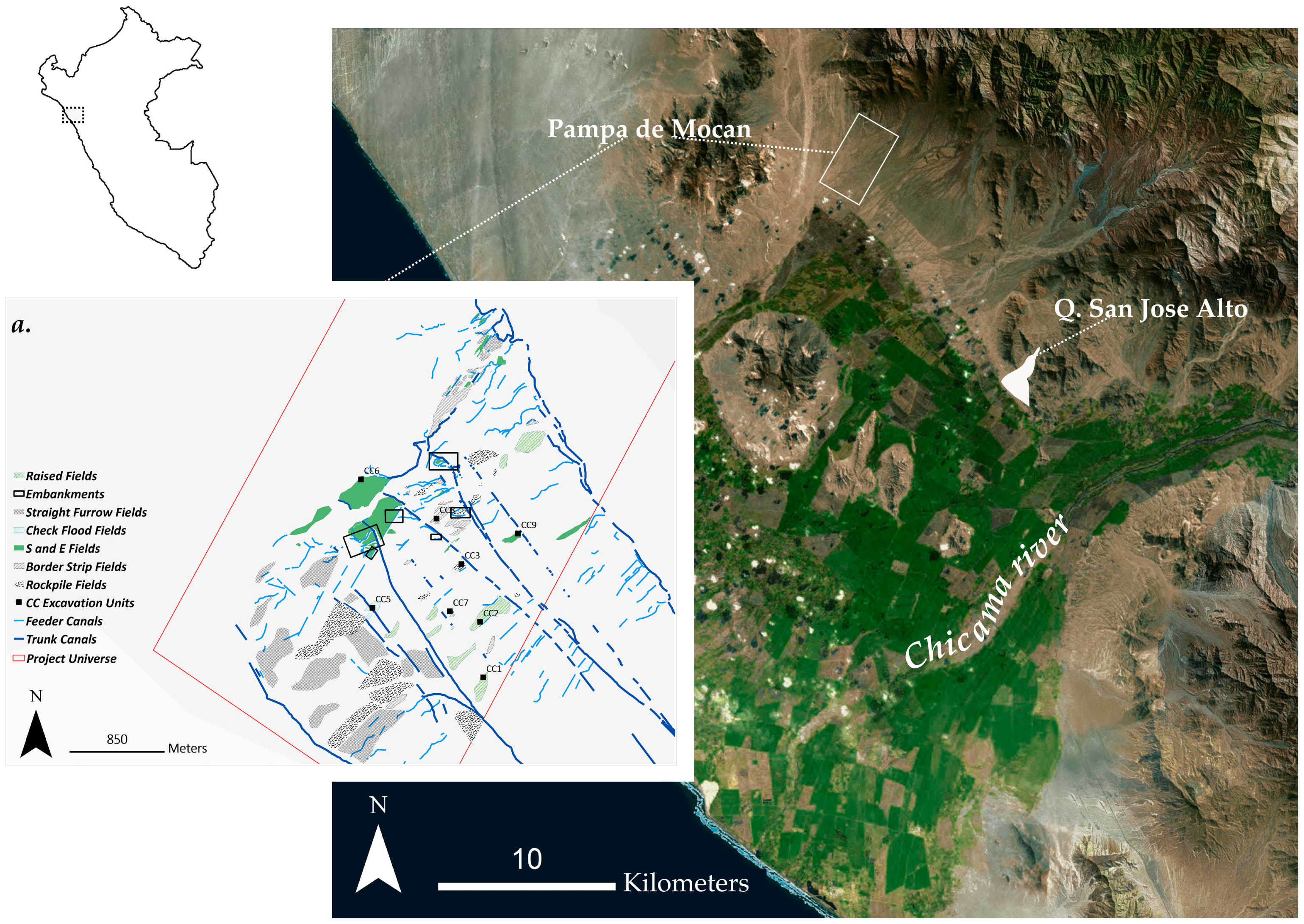
3. The Prehispanic Peruvian North Coast

The north coast of Peru is a relatively flat alluvial plain located between the Andean foothills and the Pacific Ocean. Perennial rivers descend from the high basins of the Andes and cut across the north coast plain to form river valleys. It is here that one of world’s oldest independent centers of domestication and agriculture, and an early “hydraulic society”—one that developed sophisticated and extensive irrigation canal networks—emerged beginning in the late Holocene [7,20,68]. The region is also a hyper-arid environment: the Andean rain shadow; the cold, near-coast Humboldt current; and the South Pacific anticyclone (southern oscillation) combined to establish the dry coastal conditions by 8000–6000 BP [69,70,71,72]. Most years, the mean annual precipitation along the coast ranges between 5 and 40 mm [73], with some localities, such as the Pampa de Mocan in the Chicama Valley, receiving 12 mm annually. Again, however, the average annual precipitation does not adequately describe the experience of the climate in these valleys; in fact, there are marked wet and dry seasons. For example, the Chicama River has an average monthly discharge of 7.97 m3/s in August and 400 m3/s in March [74]. The availability of water and stability of the local climate is controlled largely by the oceanic–atmospheric phenomenon known as ENSO.
El Niño Southern Oscillation (ENSO) describes the see-sawing of both oceanic and atmospheric conditions across the Pacific, and it occurs in three phases: La Niña (strong easterly winds and cooler sea surface temperatures), Neutral (average sea surface temperatures and uncoupled atmospheric patterns), and El Niño phases. During the El Niño phase of the ENSO phenomenon, sea surface temperatures (SSTs) rise, and easterly winds (blowing east to west) weaken and occasionally reverse [75]. For the northwest coast of the South American continent, this results in the weakening of the cold, Humboldt Current, allowing warm waters to reach the coasts of Peru and Ecuador. The effect is sudden rainfall events on the otherwise arid landscape, which can trigger flooding along the perennial rivers and flash floods or debris flows (huaycos) in the normally dry drainages (quebradas) along the base of the Andean foothills.
El Niño events are variable in their timing, intensity, location, and impact. On a regional and millennial scale, work by Sandweiss et al. has illuminated the multiple ‘flavors’ of East Pacific, Central Pacific, and Coastal Anomaly El Niño conditions; this research has also provided a record of the changing rhythms of the phenomenon over time [76,77,78]. On a local scale, geoarchaeological studies in the Moche and Chicama Valleys have identified the diverse factors that can determine the intensity and impact of an El Niño event, even within a single valley [79]. For example, the scale of flooding can depend on whether precipitation occurred in the middle or the lower valley, the size of the affected catchment, and the gradient of the ravine. Geographers and historians have argued that while very strong El Niño events are somewhat rare, moderate and strong events can occur as frequently as every 3–4 years [80]. El Niño events, therefore, are somewhat regular irregularities of the arid north coast environment.
Extreme arid conditions, El Niño flood hazards, irrigation systems, and agricultural history have intersected on the north coast for over 3000 years [68,81,82,83,84,85,86,87,88,89,90,91]. On the coastal plain, irrigation agriculture is thought have been well underway by 2000–1500 BCE [14]; however, clear evidence is associated with the monumental temple complex, Caballo Muerto. Located in the Moche Valley and dating back to 1400–800 BCE, this site was established near the intake of a major irrigation branch, the Vichansao Canal [92,93]. By the Early Intermediate Period (200 BCE–600 CE) riverine prehispanic canals, expertly following the topography, were sometimes cut directly into bedrock, and incorporated headgates, feeder canals, spillways, and even monumental aqueducts [81,85,94,95]. Many of these canals are still in use today. In fact, scholars argue that the prehispanic system achieved a greater area of production than even the modern agro-industrial complex in some valleys by 30–40% [7,22,96]. Ethnohistoric research has shed some light on the sociopolitical organization around irrigation management in the years just following Spanish invasion [97,98,99]; however, much remains unknown about how these vast systems operated, and even less about their operation during periods of water stress.
From the air, the vast, webbed canal branches of the Chicama Valley, north coast, Peru, appear to be part of a singular, unified system. Huckleberry et al. [100] analyzed the area of potential cultivation for two major canal branches of this Valley: the Ascope Canal System on the right margin of the river and the Intervalley (La Cumbre) Canal System on the left. Huckleberry et al. found that during peak average discharge (February–April), both branches could be irrigated simultaneously, but during approximately half of the year (June–December), when the Chicama River was well below peak flow (in August as low as 6 m3/s), only one branch could be fully irrigated at any given time [100]. This work suggests that if all canal branches (historic total is between 10 and 11, see [97]) were activated simultaneously, the system would have experienced severe water shortages. Instead, the scale of production likely oscillated alongside the seasonal fluxes of river volume. However, these models did not account for El Niño years, when river discharge can increase dramatically, but also lead to damaged intakes, water-logged fields, and widespread system failures.
While on the one hand, irrigation canals are considered the lifeblood of coastal Peruvian complex society, on the other, they are seen as uniquely vulnerable to El Niño flood events. As Van Buren [101] has examined, work by Michael E. Moseley, colleagues, and students, stemming from the Chicago Field Museum’s Programa de Riego Antiguo (PRA) (Ancient Irrigation Program), put forth an influential human ecology explanation for periods of marked cultural change on the coast. The PRA identified three major El Niño events, dated to 600 CE, 1100 CE, and 1300 CE, which were then tied to site abandonments and architectural and stylistic changes across several valleys [8,102,103,104,105,106,107,108,109,110,111,112,113]. For Moseley [7,8], ENSO-linked riverbed entrenchment and erosion, when combined with prior years of drought and tectonic uplift, significantly affected canals and their gradients, making them obsolete; the defunct irrigation system led to widespread agrarian collapse and consequent sociopolitical dissolution (and later, re-constitution) [7,8]. Satterlee [109] carried out careful reconstructions of the effects of the 1300 CE event on irrigation systems in the Mocquegua Valley (south coast) and found that the debris floods washed away canal segments and breached channels at every point where the canal crossed a quebrada and destroyed intakes (see also [114]). Satterlee et al. conclude that the scale of debris flow damage to the irrigation system would have led to famine and disease [114].
El Niño debris flows and floods, depending on their intensity, timing, and where they occur, can destroy conventional irrigation systems and any dependent food production. They also provide several much-needed resources for dryland agriculture: water, sediment, and nutrients. As discussed above, flood water runoff harvesting can capture and put these resources to agricultural use. The Pampa de Mocan, an abandoned prehispanic irrigated landscape located in the margin of the Chicama Valley, has provided evidence that water harvesting strategies were incorporated into conventional irrigation infrastructure [66].
The Pampa de Mocan is located 30 km northwest of the Chicama River, on the southern edge of the Paijan Desert, and has no perennial or active water sources, although the nearby foothills form quebradas that can be activated with ephemeral flows during rain events (Figure 1). The Pampa de Mocan, a general term for the areas of the Pampas de Huatunero and El Inca, and the Playa Mocan, makes up a total of 5800 ha of alluvial platforms and fans. This area has been largely unoccupied, likely since the Spanish invasion in 1532 CE. Evidence of prehispanic irrigation farming dates from the Early Horizon to the Late Intermediate Period (900 BCE–1460 CE), and previous research by the author has revealed the hybrid nature of this system.
The field systems across the Pampa de Mocan reflect a patchwork of water management strategies [66,115]. Eight trunk canals (A–H), their branches, and modifications fed this area, but, in addition to conventional, river-fed irrigation, the Pampa de Mocan system also includes floodwater farming fields (Figure 1). Inset A of Figure 1 presents the different types of mapped field systems, categorized by their surface treatment and irrigation type, in the study area. Canals built to channel river water co-existed with embankments, designed to capture floodwater runoff, and surface treatments and constructions designed to conserve moisture. The entire system included border-strip flooding, check-flood fields, also known on the coast as ‘posas’ [116], and conventional furrow irrigation. The Pampa de Mocan was both an irrigated landscape and an area of cultivation for diverted floodwater. However, despite the rich record of field techniques, little is known about the catchment area and debris flow management: how and where were these floods first intersected, attenuated, and collected? New work signals a potential example of such a system.

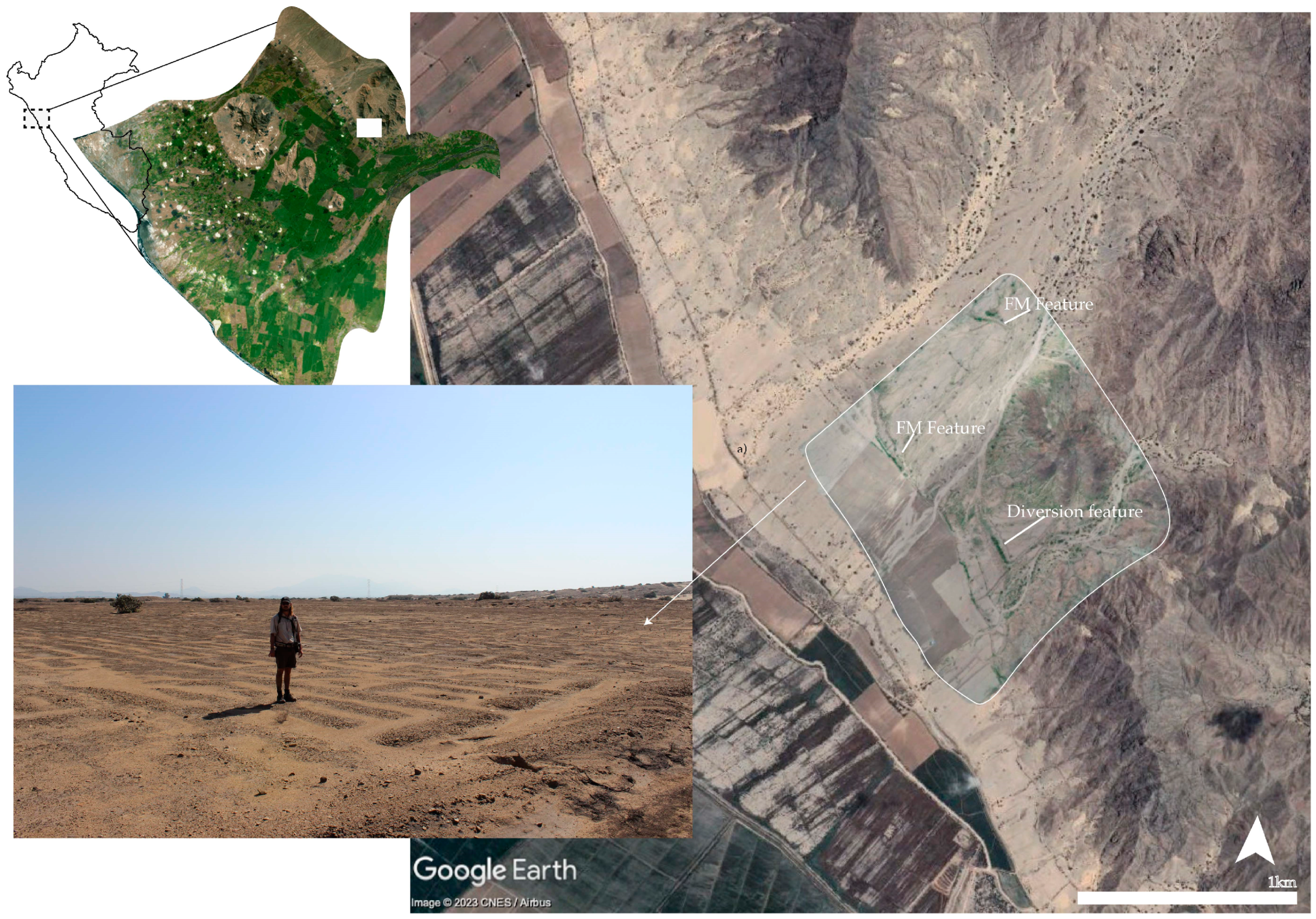
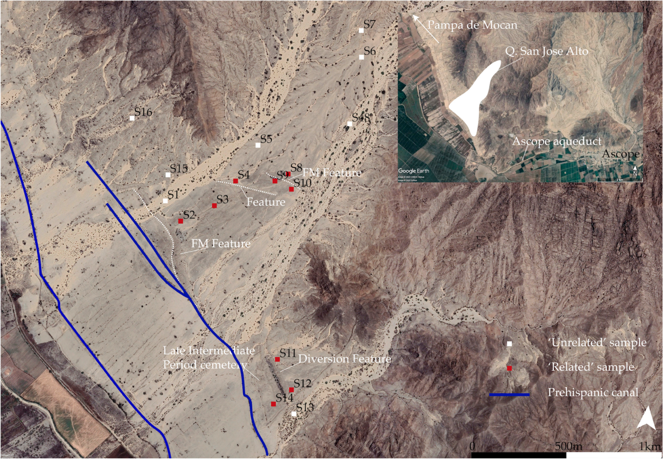
4. New Evidence of Floodwater Management in Prehispanic Peruvian Dryland Farming

Reconnaissance work in 2019 and 2023 just to the southeast of the Pampa de Mocan suggests that check-dam-like constructions (hereafter flood management (FM) features) were used for water harvesting (Figure 2). The San Jose Alto drainage is bookended at its fan by the Cerro (coastal hill) San Jose to the north and the archaeological zone and Cerro Fácala to the south; the total potential catchment area is about 60 ha. Two prehispanic canals, trunk canals that once functioned as part of the Ascope Canal System, cross the lower bajada of the drainage to the southwest. Several linear, mounded features running roughly perpendicular to the slope, cross the drainage, and connect to a diversion canal. While the original dimensions of these features are difficult to determine without targeted excavation, the currently visible extension of the mounded constructions range in width from 15 to 55 m, in height from 1.67 to 3.35 m, and in length from ~200 to 760 m. The San Jose Alto drainage could provide insights into the design and location of debris flow water-harvesting catchment systems.
While drainages like San Jose Alto are normally dry and devoid of vegetation, drone photography taken just after the most recent rainfall event (Yaku, April–May 2023) captures the effects of floodwater coming into contact with these features (Figure 2). In the drone photography overlay in Figure 2, new plant growth is visible on the mounds or floodwater management features and within the bed of the diversion feature. Vegetation cover is concentrated on the upslope side of these features, in contrast to the downslope area, which is nearly absent of any plant growth. The downslope surface appears to have been a prepared cultivation area: prehispanic fields on the surface were visible in 2019 (prior to the 2023 rainfall event) (see inset photograph in Figure 2).
Preliminary mapping and reconnaissance suggest these features and landscape date to the Late Intermediate Period (900–1460 CE); however, no formal survey or excavation has taken place. Our team did carry out an experimental soil testing survey. Using a 21-inch soil sampler probe, we collected soil samples both upslope and downslope of the check-dam-like features; upslope and downslope of the diversion feature; and several ‘control’ samples of new, alluvial sediments, and older unmodified sediments (Figure 3). No samples were taken from archaeological contexts. Using a simple, at-home soil test kit, we tested for pH, N, P, and K. The values of each were determined using color charts or visibility charts, and therefore, are not to be interpreted as equivalent to laboratory-grade analyses. Additionally, these are not archaeological samples—the results do not reflect the nutrient potency or pH of archaeological soils. Instead, these samples provide rough estimates of how these prehispanic features, when they come into contact with debris flow floodwater today, may be impacting the surrounding soils—a measure of the long-term effects of these kinds of impoundments on the dry quebrada landscape. The working hypothesis was that the soils surrounding these features would react to floodwaters in a similar way to flood-spreading or water-harvesting soils, therefore providing a point of departure for future research.
Arid zone soils are typically deficient in macronutrients; however, experimental studies have shown that pulse events can impact soil conditions [117]. As discussed above, in modern-day experiments, flood-spreading fields outperform undisturbed fields, both in vegetative production and in the potency of some essential nutrients [61,62,63]. Across these studies, while there are no significant differences in pH after flood spreading, total N, available P, and K tend to increase in soil after flood spreading [61,62,64,118].
In our soil sampling study of the San Jose Alto quebrada, samples were not collected from fields (none were visible or otherwise accessible), but rather from areas identified as potentially impacted by or ‘related’ to the FM features and diversion canal or those considered ‘unrelated’ to these features (Table 1; Figure 3). An ‘unrelated’ area, for example, could be the bed of an alluvial channel, or unmodified alluvial platforms, while ‘related’ areas were considered those in the adjacent upslope or downslope surface of the feature (within a maximum distance of 60 m from the top of the berm of a given feature). With the possible exception of one sample (S03), these soils have not been modified in recent decades; therefore, the results do not reflect the application of modern-day fertilizers or nutrients.
In total, 17 samples were collected from different points on the landscape below 400 masl in the San Jose Alto quebrada, 9 considered ‘related’ to the FM features, and 8 considered ‘unrelated’ to the features. While the results show no significant correlation between relatedness to the FM features and pH, P, or N values (P and N were generally depleted and pH was consistently 7.5 or alkaline, similar to laboratory results collected from prehispanic irrigated fields in the Pampa de Chaparrí [119]), those samples related to the archaeological features had significantly (p ≤ 0.05) higher K scores than unrelated samples. Given that these features are not being actively maintained or repaired, they are only passively functioning as impoundments, check-dams, or flood water spreaders; however, their presence in this quebrada continues to have an impact on the soil, encouraging vegetation growth, trapping moisture [120], and affecting the K value.

5. Discussion

Drylands are defined by their aridity, but also by the variability of precipitation and its extenuating effects, which constitutes a major challenge for agriculture. Today, as drylands expand due to rising global temperatures, many are seemingly faced with the challenge of keeping deserts at bay or subdued through the constant irrigation. However, trying to achieve temperate zone conditions in an arid zone is futile. As Degne states, “… arid regions are not simply a temporarily dry extension of the humid regions” [11] (p. 10). We should expect that the same variable nature that defines these regions also underwrites the farming systems located therein. Ancient farmers understood this, and a growing body of evidence confirms that dryland agricultural systems integrated both intermittent or floodwater sources and (where available) perennial water sources, even under the most extreme environmental conditions [121,122].
On the north coast of Peru, conventional irrigation supported millennia of complex societies; however, as scholars have noted, these same systems were also highly vulnerable to the kinds of sudden, destructive pulse events (El Niño floods) that characterize the region. How then were these systems sustained over the long term? Evidence presented here further supports the importance of system hybridity, which is consistent with Andean highland irrigation strategies both in the prehispanic period and modern times [123,124,125,126]. In arid zones, hybrid systems can contribute to patch diversity, soil development, and a recharged water table, while maintaining some level of productivity. Importantly, they also allow farmers to flexibly respond to periods of abundance and scarcity. In fact, the combination of water management devices and constructions, surface treatments for moisture retention and erosion prevention, sediment and water harvesting techniques used in arid zone farming systems would equate to a kind of pre-industrial ‘precision farming’ today (see [44,53,65,86,90]).
The archaeological record demonstrates that sustainable agriculture is possible in drylands when farming practices accommodate the inherent variability of these environments. The preliminary soil sampling results from the San Jose Alto quebrada in the Chicama Valley of north coast Peru suggest that some features of the floodwater management systems can continue to impact the local environmental even long after abandonment, and future work will further elucidate their roles in these landscapes. Approaching these agricultural histories from an arid land perspective, rather than projecting temperate zone expectations onto them, can reveal a suite of practices and technology, but also the systems of knowledge behind farming in some the driest places on earth.

Funding

This research was funded by Vanderbilt University and was carried out with the collaboration and support of several colleagues. I wish to acknowledge Fabian Brondi, Diana Chuquitucto, Sylvia Amaya, Lic., Carlos Vigo for their support in carrying out drone photography and reconnaissance work, and Juan Casteñeda Murga, Jesús Briceño, and Cesar Galvez for their willingness to share their thoughts, ideas, and deep knowledge of the Chicama Valley.

Data Availability Statement

Data are contained within the article.

Conflicts of Interest

The author declares no conflicts of interest.

References

  1. Flannery, K.V. Origins and ecological effects of early domestication in Iran and the Near East. In The Domestication and Exploitation of Plants and Animals; Ucko, P., Dimbleby, G.W., Eds.; Duckworth: London, UK, 1969; pp. 73–100. [Google Scholar]
  2. Bar-Yosef, O.; Valla, F. The Natufian Culture and the Origin of the Neolithic in the Levant. Curr. Anthropol. 1990, 31, 433–436. [Google Scholar] [CrossRef]
  3. Artzy, M.; Hillel, D. A Defense of the Theory of Progressive Soil Salinization in Ancient Southern Mesopotamia. Geoarchaeology Int. J. 1988, 3, 235–238. [Google Scholar] [CrossRef]
  4. Kladky, W. Salinization. In Natural Hazards and Disasters: From Avalanches and Climate Change to Water Spouts and Wildfires: Natural Hazards and Aid Organizations; Paul, B.K., Ed.; ABC-CLIO: Santa Barbara, CA, USA, 2021; pp. 171–181. [Google Scholar]
  5. Adams, R.M. Heartland of Cities: Surveys of Ancient Settlement and Land Use on the Central Floodplain of the Euphrates; University of Chicago Press: Chicago, IL, USA, 1981. [Google Scholar]
  6. Adams, R.M. Land behind Baghdad: A History of Settlement on the Diyala Plains; University of Chicago Press: Chicago, IL, USA, 1965. [Google Scholar]
  7. Moseley, M.E. The Good Old Days Were Better: Agrarian Collapse and Tectonics. Am. Anthropol. 1983, 85, 773–779. [Google Scholar] [CrossRef]
  8. Moseley, M.E. Punctuated equilibrium: Searching the ancient record for El Niño. Q. Rev. Archaeol. 1987, 8, 7–10. [Google Scholar]
  9. Moseley, M.E. Convergent Catastrophe: Past Patterns and Future Implications of Collateral Natural Disasters in the Andes. In The Angry Earth: Disaster in Anthropological Perspective; Oliver-Smith, A., Hoffman, S.M., Eds.; Routledge: New York, NY, USA, 1999; pp. 59–72. [Google Scholar]
  10. Sullivan, S. Towards a non-equilibrium ecology: Perspectives from an Arid Land. J. Biogeogr. 1996, 23, 1–5. [Google Scholar]
  11. Dregne, H.E. (Ed.) Arid Lands in Transition; American Association for the Advancement of Science: Washington, DC, USA, 1970. [Google Scholar]
  12. Mirzabaev, A.; Stringer, L.C.; Benjaminsen, T.A.; Gonzalez, P.; Harris, R.; Jafari, M.; Stevens, N.; Tirado, C.M.; Zakieldeen, S. Cross-Chapter Paper 3: Deserts, Semiarid Areas and Desertification. In Climate Change 2022: Impacts, Adaptation and Vulnerability; Pörtner, H.-O., Roberts, D.C., Tignor, M., Poloczanska, E.S., Mintenbeck, K., Alegri, A., Craig, M., Langsdorf, S., Löschke, S., Möller, V., et al., Eds.; Contribution of Working Group II to the Sixth Assessment Report of the Intergovernmental Panel on Climate Change; Cambridge University Press: New York, NY, USA, 2022. [Google Scholar]
  13. Ahmed, Z.; Gui, D.; Murtaza, G.; Yunfei, L.; Ali, S. An Overview of Smart Irrigation Management for Improving Water Productivity under Climate Change in Drylands. Agronomy 2023, 13, 2113. [Google Scholar] [CrossRef]
  14. Pozorski, S.; Pozorski, T. Early Settlement and Subsistence in the Casma Valley, Peru; University of Iowa Press: Iowa City, IA, USA, 1987. [Google Scholar]
  15. Gamo, M.; Shinoda, M.; Maeda, T. Classification of arid lands, including soil degradation and irrigated areas, based on vegetation and aridity indices. Int. J. Remote Sens. 2013, 34, 6701–6722. [Google Scholar] [CrossRef]
  16. Willey, G.R. Prehistoric Settlement Patterns in the Virú Valley, Peru; Bureau of American Ethnology Bulletin; Smithsonian Institution, Ed.; U.S. Government Printing Office: Washington, DC, USA, 1953.
  17. Cárdenas Martín, M.; Villena, C.M. El Desierto de Sechura en la Arqueologia Peruana. Rev. Univ. Catól. 1980, 8, 107–117. [Google Scholar]
  18. Levick, L.R.; Goodrich, D.C.; Hernandez, M.; Fonseca, J.; Semmens, D.J.; Stromberg, J.; Tluczek, M.; Leidy, R.A.; Scianni, M.; Guertin, D.P.; et al. The Ecological and Hydrological Significance of Ephemeral and Intermittent Streams in the Arid and Semi-Arid American Southwest; U.S. Environmental Protection Agency Office of Research and Development, Ed.; U.S. Environmental Protection Agency Office of Research and Development: Washington, DC, USA, 2008.
  19. Quandt, A. Coping with drought: Narratives from smallholder farmers in semi-arid Kenya. Int. J. Disaster Risk Reduct. 2021, 57, 102168. [Google Scholar] [CrossRef]
  20. Steward, J.H. Irrigation Civilizations: A Comparative Study; Social Science Section, Department of Cultural Affairs, Pan American Union: Washington, DC, USA, 1955. [Google Scholar]
  21. Spooner, B. Irrigation and Society: The Iranian Plateau. In Irrigation’s Impact on Society; Downing, T., Gibson, M., Eds.; The University of Arizaona Press: Tucson, AZ, USA, 1974; pp. 43–58. [Google Scholar]
  22. Kosok, P. Life, Land and Water in Ancient Peru; Long Island University Press: New York, NY, USA, 1965. [Google Scholar]
  23. Casana, J. Global-Scale Archaeological Prospection using CORONA Satellite Imagery: Automated, Crowd-Sourced, and Expert-led Approaches. J. Field Archaeol. 2020, 45 (Suppl. S1), S89–S100. [Google Scholar] [CrossRef]
  24. Ur, J. Sennacherib’s Northern Assyrian Canals: New Insights from Satellite Imagery and Aerial Photography. Iraq 2005, 67, 317–345. [Google Scholar] [CrossRef]
  25. Wittfogel, K.A. Oriental Despotism: A Comparative Study of Total Power; Yale University Press: New Haven, CT, USA, 1957. [Google Scholar]
  26. Adams, R.M. The Evolution of Urban Society: Early Mesopotamia and Prehispanic Mexico; Aldine Publishing Co.: Chicago, IL, USA, 1966. [Google Scholar]
  27. Bennett, W.C. (Ed.) The Peruvian Co-tradition. In A Reappraisal of Peruvian Archaeology; Society for American Archaeology: Menasha, WI, USA, 1948. [Google Scholar]
  28. Moseley, M.E. Organizational Preadaptation to Irrigation: The Evolution of the Early Water-Management Systems in Coastal Peru. In Irrigation’s Impact on Society; Downing, T., Gibson, M., Eds.; The University of Arizona Press: Tucson, AZ, USA, 1974; pp. 77–82. [Google Scholar]
  29. Moseley, M.E.; Day, K.C. Chan Chan, Andean Desert City; University of New Mexico Press: Albuquerque, NM, USA, 1982. [Google Scholar]
  30. Hunt, R.C. Size and the Structure of Authority in Canal Irrigation Systems. J. Anthropol. Res. 1988, 44, 335–355. [Google Scholar] [CrossRef]
  31. Hunt, R.C. Reply to Price. J. Anthropol. Res. 1994, 50, 205–211. [Google Scholar] [CrossRef]
  32. Price, B.J. Prehispanic irrigation agriculture in nuclear america. Lat. Am. Res. Rev. 1971, 6, 3–60. [Google Scholar] [CrossRef]
  33. Price, D.H. Wittfogel’s Neglected Hydraulic/Hydroagricultural Distinction. J. Anthropol. Res. 1994, 50, 187–204. [Google Scholar] [CrossRef]
  34. Boserup, E. The Conditions of Agricultural Growth: The Economics of Agrarian Change under Population Pressure; G. Allen and Unwin: London, UK, 1965. [Google Scholar]
  35. Erickson, C.L. Intensification, Political Economy, and the Farming Community; In Defense of a Bottom-Up Perspective of the Past. In Agricultural Strategies; Marcus, J., Stanish, C., Eds.; Cotsen Institute of Archaeology, University of California: Los Angeles, CA, USA, 2006; pp. 334–363. [Google Scholar]
  36. Hesse, R.; Baade, J. Irrigation agriculture and the sedimentary record in the Palpa Valley, Southern Peru. Catena 2009, 77, 119–129. [Google Scholar] [CrossRef]
  37. Strawhacker, C. Sustaining Irrigation Agriculture for the Long-Term: Lessons on Maintaining Soil Quality from Ancient Agricultural Fields in the Phoenix Basin and on the North Coast of Peru. Ph.D. Thesis, Arizona State University, Tempe, AZ, USA, 2013. [Google Scholar]
  38. Baade, J. Irragric anthrosols—Artifacts of human adaptation to arid conditions: Examples from the high Himalaya and the coastal desert of Peru. In Climates, Landscapes, and Civilizations; Giosan, L., Fuller, D.Q., Nicoll, K., Flad, R.K., Clift, P.D., Eds.; American Geophysical Union: Washington, DC, USA, 2013. [Google Scholar]
  39. Lobell, D.; Bala, G.; Mirin, A.; Phillips, T.; Maxwell, R.; Rotman, D. Regional Differences in the Influence of Irrigation on Climate. J. Clim. 2009, 22, 2248–2255. [Google Scholar] [CrossRef]
  40. Heng, T.; Ma, Y.; Ai, P.; Liu, Z.; Wu, M.; Liu, C. The Effects of Soil Salt Stress on the Nitrogen Uptake, Yield Response and Nitrogen Use Efficiency of Cotton in Arid Areas. Agronomy 2024, 14, 229. [Google Scholar] [CrossRef]
  41. Gao, S.; Wang, X.; Xu, S.; Su, T.; Tang, Q.; Sheng, J. Soil Salinity Mapping of Croplands in Arid Areas Based on the Soil-Land Inference Model. Agronomy 2023, 13, 3074. [Google Scholar] [CrossRef]
  42. Norton, J.B. Agroecology, Hydrology, and Conservation of Ephemeral Streams and Alluvial Fans, Zuni Pueblo, New Mexico. Ph.D. Thesis, University of Montana, Missoula, MT, USA, 2000. [Google Scholar]
  43. Blaikie, P.M.; Brookfield, H.C. Land Degradation and Society; Routledge: New York, NY, USA, 1987. [Google Scholar]
  44. Evenari, M.; Shanan, L.; Tadmor, N. The Negev: The Challenge of a Desert; Harvard University Press: Cambridge, MA, USA, 1982. [Google Scholar]
  45. Fish, S.K. Corn, Crops and Cultivation in the North American Southwest. In People and Plants in Ancient Western North America; Minnis, P.E., Ed.; Smithsonian Institution: Washington, DC, USA, 2004; pp. 115–163. [Google Scholar]
  46. El-Beltagi, H.S.; Basit, A.; Mohamed, H.I.; Ali, I.; Ullah, S.; Kamel, E.A.R.; Shalaby, T.A.; Ramadan, K.M.A.; Alkhateeb, A.A.; Ghazzawy, H.S. Mulching as a Sustainable Water and Soil Saving Practice in Agriculture: A Review. Agronomy 2022, 12, 1881. [Google Scholar] [CrossRef]
  47. Pringle, C. Hydrologic connectivity and the management of biological reserves: A global perspective. Ecol. Appl. 2001, 11, 981–998. [Google Scholar] [CrossRef]
  48. Prinz, D. Water Harvesting-Past and Future. In Sustainability of Irrigated Agriculture; Springer: Berlin/Heidelberg, Germany, 1996; pp. 137–168. [Google Scholar]
  49. Critchley, W.; Siegert, K. Water Harvesting: A Manual for the Design and Construction of Water Harvesting Schemes for Plant Production; Food and Agriculture Organization of the United Nations: Rome, Italy, 1991; pp. 1–154. [Google Scholar]
  50. Valdez, F. (Ed.) Agricultura Ancestral: Camellones y Albarradas: Contexto Social, Usos y Retos del Pasado y del Presente; IFEA: Lima, Peru, 2006. [Google Scholar]
  51. Erickson, C.L. An Archaeological Investigation of Raised Field Agriculture in the Lake Titicaca Basin of Peru. Ph.D. Thesis, University of Illinois at Urbana-Champaign, Champaign, IL, USA, 1988. [Google Scholar]
  52. Erickson, C.L. The domesticated landscapes of the Bolivian Amazon. In Time and Complexity in Historical Ecology: Studies in the Neotropical Lowlands; Baleé, W., Erickson, C.L., Eds.; Columbia University Press: New York, NY, USA, 2006. [Google Scholar]
  53. Fish, S.K. Hohokam Impacts on Sonoran Desert Environment. In Imperfect Balance: Landscape Transformations in the Precolumbian Americas; Lentz, D.L., Ed.; Columbia University Press: New York, NY, USA, 2000; pp. 252–278. [Google Scholar]
  54. Doolittle, W.E. Agricultural Change as an Incremental Process. Ann. Assoc. Am. Geogr. 1984, 74, 124–137. [Google Scholar] [CrossRef]
  55. Nabhan, G.P. Papgo indian desert agriculture and water control in the Sonoran Desert, 1697–1934. Appl. Geogr. 1986, 6, 43–59. [Google Scholar] [CrossRef]
  56. Fish, S.K.; Fish, P.R. Prehistoric Landscapes of the Sonoran desert Hohokam. Popul. Environ. 1992, 13, 269–283. [Google Scholar] [CrossRef]
  57. Logan, M.F. Head-Cuts and Check-Dams: Changing Patterns of Environmental Manipulation by the Hohokam and Spanish in the Santa Cruz River Valley, 200–1820. Environ. Hist. 1999, 4, 405–430. [Google Scholar] [CrossRef]
  58. Erickson, C.L. The Lake Titicaca Basin: A Pre-Columbian Built Landscape. In Imperfect Balance: Landscape Transformations in the Precolumbian Americas; Lentz, D., Ed.; Columbia University Press: New York, NY, USA, 2000; pp. 311–356. [Google Scholar]
  59. Lentz, D.L. (Ed.) Imperfect Balance; Columbia University Press: New York, NY, USA, 2000. [Google Scholar]
  60. Heede, B.H. Design, Construction, and Cost of Rock Check Dams; U.S. Department of Agriculture, Forest Service, Rocky Mountain Forest and Range Experiment Station: Fort Collins, CO, USA, 1966.
  61. Ghazavi, R.; Vali, A.; Eslamian, S. Implact of Flood Spreading on Infiltration Rate and Soil Properties in an Arid Environment. Water Resour. Manag. 2010, 24, 2781–2793. [Google Scholar] [CrossRef]
  62. Oskoee, R.S.; Mahdian, M.H.; Razzagi, S. Feasibility of Recovering Soil Nutrients through Flood Water Spreading. Ecopersia 2015, 3, 1089–1097. [Google Scholar]
  63. Ghaleno, M.R.D.; Saberia, M.; Lalozaei, A. Studying the effects of flood water spreading on changes of topsoil and vegetation (case study: Hamun Region of Sistan, Iran). Int. J. Agric. Crop Sci. 2013, 5–7, 712–717. [Google Scholar]
  64. Hashemi, S.S.; Abbaslou, H. Potassium reserves in soils with arid and semi-arid climate in southern Iran: A perspective based on potassium fixation. Iran Agric. Res. 2016, 35, 88–95. [Google Scholar]
  65. Huckleberry, G. Soil Evidence of Hohokam Irrigation in the Salt River Valley, Arizona. Kiva 1992, 57, 237–249. [Google Scholar] [CrossRef]
  66. Caramanica, A.; Huaman Mesia, L.; Morales, C.R.; Huckleberry, G.; Castillo, B.L.J.; Quilter, J. El Niño resilience farming on the north coast of Peru. Proc. Natl. Acad. Sci. USA 2020, 117, 24127–24137. [Google Scholar] [CrossRef]
  67. Denevan, W.M. Cultivated Landscapes of Native Amazonia and the Andes; Oxford University Press: New York, NY, USA, 2001. [Google Scholar]
  68. Billman, B.R. Irrigation and the Origins of the Southern Moche State on the North Coast of Peru. Lat. Am. Antiq. 2002, 13, 371–400. [Google Scholar] [CrossRef]
  69. Sandweiss, D.H. Terminal Pleistocene through Mid-Holocene archaeological sites as paleoclimatic archives for the Peruvian coast. Palaeogeogr. Palaeoclimatol. Palaeoecol. 2003, 194, 23–40. [Google Scholar] [CrossRef]
  70. Sandweiss, D.H.; Maasch, K.; Anderson, D.G. Transitions in the Mid-Holocene. Science 1999, 283, 499–500. [Google Scholar] [CrossRef]
  71. Thompson, L.G.; Mosley-Thompson, E.; Davis, M.E.; Lin, P.-N.; Henderson, K.A.; Cole-Dai, J.; Bolzan, J.F.; Liu, K.-B. Late Glacial Stage and Holocene Tropical Ice Core Records from Huascarán, Peru. Science 1995, 269, 46–50. [Google Scholar] [CrossRef]
  72. Wells, L.E. Holocene Fluvial and Shoreline History as a Function of Human and Geologic Factors in Arid Northern Peru. Ph.D. Thesis, Stanford University, Stanford, CA, USA, 1988. [Google Scholar]
  73. Wells, L.E.; Noller, J.S. Holocene Coevolution of the Physical Landscape and Human Settlement in Northern Coastal Peru. Geoarchaeology 1999, 14, 755–789. [Google Scholar] [CrossRef]
  74. Oficina Nacional de Evaluacion de Recursos Naturales (ONERN). Inventario, Evaluacion y Uso Racional de los Recursos Naturales de la Costa: Cuenca del Rio Chicama; Oficina Nacional de Evaluacion de Recursos Naturales (ONERN): Lima, Peru, 1973.
  75. Wang, C.; Fiedler, P.C. ENSO variability and the eastern tropical Pacific: A review. Prog. Oceanogr. 2006, 69, 239–266. [Google Scholar] [CrossRef]
  76. Sandweiss, D.H.; Andrus, C.F.T.; Kelley, A.R.; Maasch, K.A.; Reitz, E.J.; Roscoe, P.B. Archaeological climate proxies and the complexities of reconstructing Holocene El Niño in coastal Peru. Proc. Natl. Acad. Sci. USA 2020, 117, 8271–8279. [Google Scholar] [CrossRef] [PubMed]
  77. Sandweiss, D.H.; Kirk, A.M.; Burger, R.L.; Richardson, J.B., III; Rollins, H.B.; Clement, A. Variation in Holocene El Niño frequencies: Climate records and cultural consequences in ancient Peru. Geology 2001, 29, 603–606. [Google Scholar] [CrossRef]
  78. Sandweiss, D.H.; Richardson, J.B., III; Reitz, E.J.; Rollins, H.B.; Maasch, K.A. Geoarchaeological Evidence from Peru for a 5000 Years B.P. Onset of El Niño. Science 1996, 273, 1531–1533. [Google Scholar] [CrossRef]
  79. Billman, B.R.; Huckleberry, G. Deciphering the Politics of Prehistoric el Niño Events on the North Coast of Peru. In El Niño, Catastrophism, and Culture Change in Ancient America; Sandweiss, D.H., Quilter, J., Eds.; Dumbarton Oaks Research Library and Collection: Washington, DC, USA, 2008. [Google Scholar]
  80. Quinn, W.H.; Neal, V.T.; de Mayolo, S.E.A. El Niño Occurrences over the Past Four and a Half Centuries. J. Geophys. Res. 1987, 92, 14449–14461. [Google Scholar] [CrossRef]
  81. Ortloff, C.R.; Moseley, M.E.; Feldman, R.A. Hydraulic Engineering Aspects of the Chimu Chicama-Moche Intervalley Canal. Am. Antiq. 1982, 47, 572–595. [Google Scholar] [CrossRef]
  82. Eling, H.H., Jr. The Role of Irrigation Networks in Emerging Societal Complexity during Late Prehispanic Times: Jequetepeque Valley, North Coast, Peru. Ph.D. Thesis, University of Texas, Austin, TX, USA, 1987. [Google Scholar]
  83. Hayashida, F.M. The Pampa de Chaparri: Water, Land, and Politics on the North Coast of Peru. Lat. Am. Antiq. 2006, 17, 243–263. [Google Scholar] [CrossRef]
  84. Téllez, S.; Hayashida, F. Campos de Cultivo Prehispánicos en la Pampa de Chaparrí. Bol. Arqueol. PUCP 2004, 8, 373–390. [Google Scholar] [CrossRef]
  85. Sherbondy, J.E. El regadío en el área Andina Central: Ensayo de distribución geográfica. Rev. Esp. Antropol. Am. 1969, 4, 113–143. [Google Scholar]
  86. Kus, J. Selected Aspects of Irrigated Agriculture in the Chimu Heartland, Peru. Ph.D. Thesis, University of California, Los Angeles, CA, USA, Ann Arbor, MI, USA, 1972. [Google Scholar]
  87. Clément, M.C. The Oasis of the Chicama Valley: Water Management from the Chimú to the Spaniards (Eleventh to Seventeenth Century AD) on the North Coast of Peru. In Oases and Globalisation: Ruptures and Continuities; Lavie, E., Marshall, A., Eds.; Springer: London, UK, 2017; pp. 73–88. [Google Scholar]
  88. Dillehay, T.D.; Eling, H.H., Jr.; Rossen, J. Preceramic Irrigation Canals in the Peruvian Andes. Proc. Natl. Acad. Sci. USA 2005, 102, 17241–17244. [Google Scholar] [CrossRef] [PubMed]
  89. Goodbred, S.L., Jr.; Dillehay, T.D.; Mora, C.G.; Sawakuchi, A.O. Transformation of maritime desert to an agricultural center: Holocene environmental change and landscape engineering in Chicama River valley, northern Peru coast. Quat. Sci. Rev. 2020, 227, 106046. [Google Scholar] [CrossRef]
  90. Caramanica, A. Land, Labor, and Water of the Ancient Agricultural Pampa de Mocan, North Coast, Peru. Ph.D. Thesis, Harvard University, Cambridge, MA, USA, 2018. [Google Scholar]
  91. Watson, R.P. Water Control and Land Use on the Arid North Coast of Peru: Prehispanic Agricultural Systems in the Chicama Valley. Ph.D. Thesis, The University of Texas, Austin, TS, USA, 1979. [Google Scholar]
  92. Nesbitt, J. Excavations at Caballo Muerto: An Investigation into the Origins of the Cupisnique Culture. Ph.D. Thesis, Yale University, New Haven, CT, USA, 2012. [Google Scholar]
  93. Moseley, M.E.; Deeds, E.E. The Land in Front of Chan Chan: Agrarian Expansion, Reform, and Collapse in the Moche Valley. In Chan Chan: Ancient Desert City; Moseley, M.E., Day, K.C., Eds.; University of New Mexico Press: Albuquerque, NM, USA, 1982; pp. 25–53. [Google Scholar]
  94. Farrington, I.S. Land Use, Irrigation and Society on the North Coast of Peru in the Prehispanic Era. Z. Fuer Bewaesserungswirtschaft 1977, 2, 151–186. [Google Scholar]
  95. Farrington, I.S.; Park, C.C. Hydraulic Engineering and Irrigation Agriculture in the Moche Valley, Peru: C. A.D. 1250–1532. J. Archaeol. Sci. 1978, 5, 255–268. [Google Scholar] [CrossRef]
  96. Park, C.C. Water Resources and Irrigation Agriculture in Pre-Hispanic Peru. Geogr. J. 1983, 149, 153–166. [Google Scholar] [CrossRef]
  97. Netherly, P.J. The Management of Late Andean Irrigation Systems on the North Coast of Peru. Am. Antiq. 1984, 49, 227–254. [Google Scholar] [CrossRef]
  98. Netherly, P.J. Hispanic and Andean Irrigation in the Sixteenth Century: A Comparison in Adaptive Efficiency. In Seminar 1/Fernand Braudel Center for the Study of Economies, Historical Systems and Civilizations; State University of New York at Binghamton: Binghamton, NY, USA, 1981. [Google Scholar]
  99. Castañeda Murga, J.; Millaire, J.F. Agua, Tierra y Recursos. Una Historia ambiental del Valle de Virú, SS. XVI–XIX. Perspect. Latinoam. 2015, 12, 50–67. [Google Scholar]
  100. Huckleberry, G.; Caramanica, A.; Quilter, J. Dating the Ascope Canal System: Competition for Water during the Late Intermediate Period in the Chicama Valley, North Coast of Peru. J. Field Archaeol. 2017, 43, 17–30. [Google Scholar] [CrossRef]
  101. Van Buren, M. The Archaeology of el Niño Events and Other “Natural” Disasters. J. Archaeol. Method Theory 2001, 8, 129–149. [Google Scholar] [CrossRef]
  102. Nials, F.L.E.E.D.; Moseley, M.E.; Pozorski, S.G.; Pozorski, T.G.; Feldman, R. El Niño: The Catastrophic Flooding of Coastal Peru. Field Mus. Nat. Hist. Bull. 1979, 50, 4–14. [Google Scholar]
  103. Craig, A.K.; Shimada, I. El Niño Flood Deposits at Batán Grande, Northern Peru. Geoarchaeology 1986, 1, 29–38. [Google Scholar] [CrossRef]
  104. Delle Rose, M. Landscape Modifications Ascribed to El Niño Events in Late Pre-Hispanic Coastal Peru. Land 2022, 11, 2207. [Google Scholar] [CrossRef]
  105. Moseley, M.E. Structure and history in the dynastic lore of Chimor. In The Northern Dynasties: Kingship and Statecraft in Chimor; Moseley, M.E., Cordy-Collins, A., Eds.; Dumbarton Oaks: Washington, DC, USA, 1990. [Google Scholar]
  106. Moseley, M.E.; Richardson, J.B. Doomed by natural disaster. Archaeology 1992, 45, 44–45. [Google Scholar]
  107. Donnan, C.B. An assessment of the validity of the Naymlap dynasty. In The Northern Dynasties: Kingship and Statecraft in Chimor; Moseley, M.E., Cordy-Collins, A., Eds.; Dumbarton Oaks: Washington, DC, USA, 1990. [Google Scholar]
  108. Shimada, I. Cultural continuitues and discontinuities on the northern coast of Peru, middle-late horizons. In The Northern Dynasties: Kingship and Statecraft in Chimor; Moseley, M.E., Cordy-Collins, A., Eds.; Dumbarton Oaks: Washington, DC, USA, 1990. [Google Scholar]
  109. Satterlee, D.R. The Impact of a Fourteenth Century El Niño Flood on an Indigenous Population Near Ilo, Peru. Ph.D. Thesis, University of Florida, Gainesville, FL, USA, 1993. [Google Scholar]
  110. Bawden, G.; Reycraft, R.M. Environmental Disaster and the Archaeology of Human Response; Maxwell Museum of Anthropology: Albuquerque, NM, USA, 2000. [Google Scholar]
  111. Reycraft, R.M. The Terminal Chiribaya Project: The Archaeology of Human Response to Natural Disaster in South Coastal Peru. Ph.D. Thesis, University of New Mexico, Albuquerque, NM, USA, 1998. [Google Scholar]
  112. Williams, P.R. The Role of Disaster in the Development of Agriculture and the Evolution of Social Complexity in the South-Central Andes. Ph.D. Thesis, University of Florida, Gainesville, FL, USA, 1997. [Google Scholar]
  113. Wells, L.E. Holocene history of the El Niño phenomenon as recorded in flood sediments of northern coastal Peru. Geology 1990, 18, 1134–1137. [Google Scholar] [CrossRef]
  114. Satterlee, D.R.; Moseley, M.E.; Keefer, D.K.; Tapia A., J.E. The Miraflores El Niño Disaster: Convergent Catastrophes and Prehistoric Agrarian Change in Southern Peru. Andean Past 2000, 6, 95–116. [Google Scholar]
  115. Caramanica, A. Building resilience from risk: Interactions across ENSO, local environment, and farming systems on the desert north coast of Peru (1100BC–AD1460). Holocene 2022, 32, 1410–1421. [Google Scholar] [CrossRef]
  116. Hatch, J.K. The Corn Farmers of Motupe. Ph.D. Thesis, University of Wisconsin, Madison, WI, USA, 1974. [Google Scholar]
  117. Nabhan, G.P. The ecology of floodwater farming in arid south-western North America. Agro-Ecosystems 1979, 5, 245–255. [Google Scholar] [CrossRef]
  118. Soleimani, R.; Azami, A. The impact of flood spreading and Prosopis juliflora on a loamy sand soil. Int. J. Environ. Sci. Technol. 2019, 16, 4563–4570. [Google Scholar] [CrossRef]
  119. Nordt, L.; Hayashida, F.; Hallmark, T.; Crawford, C. Late Prehistoric Soil Fertility, Irrigation Management, and Agricultural Production in Northwest Coastal Peru. Geoarchaeology 2004, 19, 21–46. [Google Scholar] [CrossRef]
  120. Getnet, M.; Amede, T.; Tilahun, G.; Legesse, G.; Gumma, M.K.; Adebe, H.; Gashaw, T.; Ketter, C.; Akker, E.V. Water spreading weirs altering flood, nutrient distribution and crop productivity in upstream-downstream settings in dry lowlands of Afar, Ethiopia. Renew. Agric. Food Syst. 2022, 37 (Suppl. S1), S17–S27. [Google Scholar] [CrossRef]
  121. Barnard, H.; Dooley, A.N. An Ancient Irrigation Canal in the Pampa Tamarugal (Chile). J. Field Archaeol. 2017, 42, 259–268. [Google Scholar] [CrossRef]
  122. Sandor, J.A.; Huckleberry, G.; Hayashida, F.M.; Parcero-Oubiña, C.; Salazar, D.; Troncoso, A.; Ferro-Vázquez, C. Soils in ancient irrigated agricultural terraces in the Atacama Desert, Chile. Geoarchaeology 2021, 37, 96–119. [Google Scholar] [CrossRef]
  123. Zimmerer, K.S. The Origins of Andean Irrigation. Nature 1995, 378, 481–483. [Google Scholar] [CrossRef]
  124. Lane, K. Water Technology in the Andes. In Enclycopaedia of the History of Science, Technology, and Medicine in Non-Western Cultures; Springer: Dordrecht, The Netherlands, 2014; pp. 1–24. [Google Scholar]
  125. Lane, K. Water, Silt and Dams: Prehispanic Geological Storage in the Cordillera Negra, North-Central Andes, Peru. Rev. Glaciares Ecosistemas Mont. 2017, 2, 41–50. [Google Scholar]
  126. Lane, K. Engineering Resilience to Water Stress in the Late Prehispanic North-Central Andean Highlands (~600–1200BP). Water 2021, 13, 1028. [Google Scholar] [CrossRef]
Figure 1. The Chicama Valley, north coast, Peru. Locations of the perennial Chicama river, Quebrada San Jose Alto, and Pampa de Mocan, labeled. (a) Inset of previous archaeological mapping of different field types identified in the Pampa de Mocan, including fields likely irrigated with floodwater (raised fields, embankment fields, border-strip, and rockpile fields). Google Earth Pro (2015) UTM 17M705664.97 E; 9157125 S.
Agronomy 14 00407 g001
Figure 2. Drone photography overlay on Google Earth Pro imagery of the Quebrada San Jose Alto. Drone photography dates to 2023, one month post Yaku rain event. Note the post-rainfall vegetation clustering around floodwater management features. Ground photo dates to 2019 (pre-rainfall event). Person for scale standing in a relic prehispanic agricultural field. Google Earth Pro (2019) UTM 17 M 703374.9 E; 9148571.46 S. Drone photography carried out by Fabian Brondi. Photograph by the author.
Agronomy 14 00407 g002
Figure 3. Quebrada San Jose. Floodwater management (FM) features and diversion feature labeled. Soil sample locations, and their ‘relatedness’ to the features also labeled. Google Earth Pro (2019) UTM 17 M 703374.9 E; 9148571.46 S.
Agronomy 14 00407 g003
Table 1. Soil samples classified as ‘related’ or ‘unrelated’ to floodwater management features and K score determined using a Luster Leaf Professional at-home Soil Test Kit.
‘Related’ to FM Feature Sample NumberPotassium (K) Score‘Unrelated’ to FM Feature Sample NumberPotassium (K) Score
S112S130
S120S010
S144S150
S084S160
S094S054
S103S063
S023S070
S044S480
S030
Disclaimer/Publisher’s Note: The statements, opinions and data contained in all publications are solely those of the individual author(s) and contributor(s) and not of MDPI and/or the editor(s). MDPI and/or the editor(s) disclaim responsibility for any injury to people or property resulting from any ideas, methods, instructions or products referred to in the content.

