Assessing Within-Field Variation in Alfalfa Leaf Area Index Using UAV Visible Vegetation Indices
Abstract
1. Introduction
2. Materials and Methods
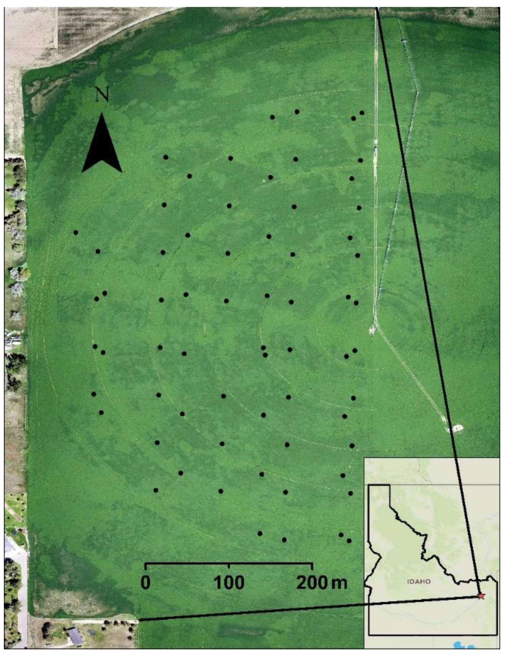
2.1. Description of Study Site
2.2. Measurement of Canopy Height and Leaf Area Index
2.3. Spatial Statistical Analysis
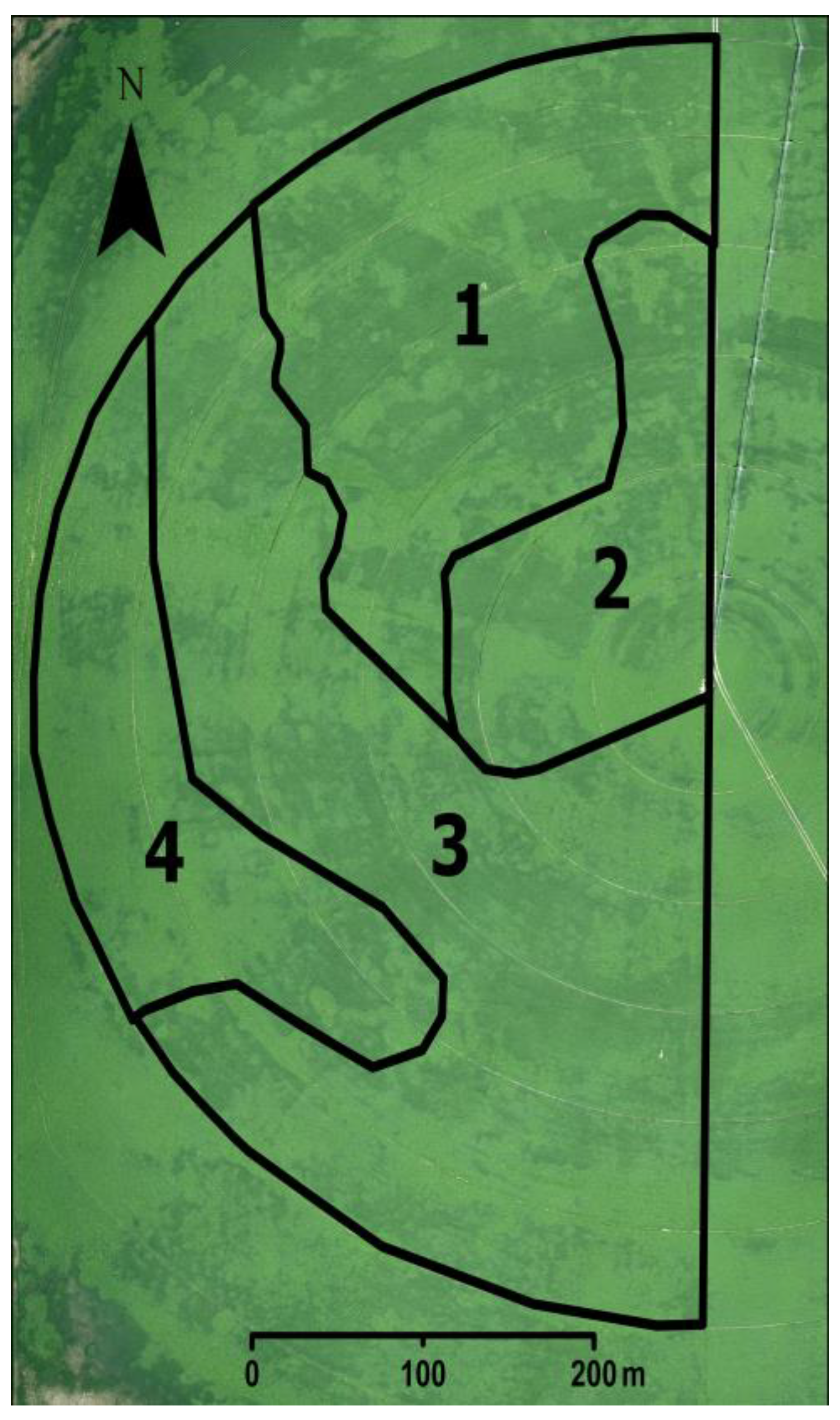
2.4. Management Zone Delineation
2.5. UAV Imagery Acquisition
2.6. Image Processing
2.7. Resampling Methods
2.8. Visible Vegetation Indices (VVIs) Calculations
2.9. Model Development and Validation Datasets
2.10. Regression Modeling
2.11. Model Evaluation Statistics
2.12. Zone Statistical Analysis
3. Results
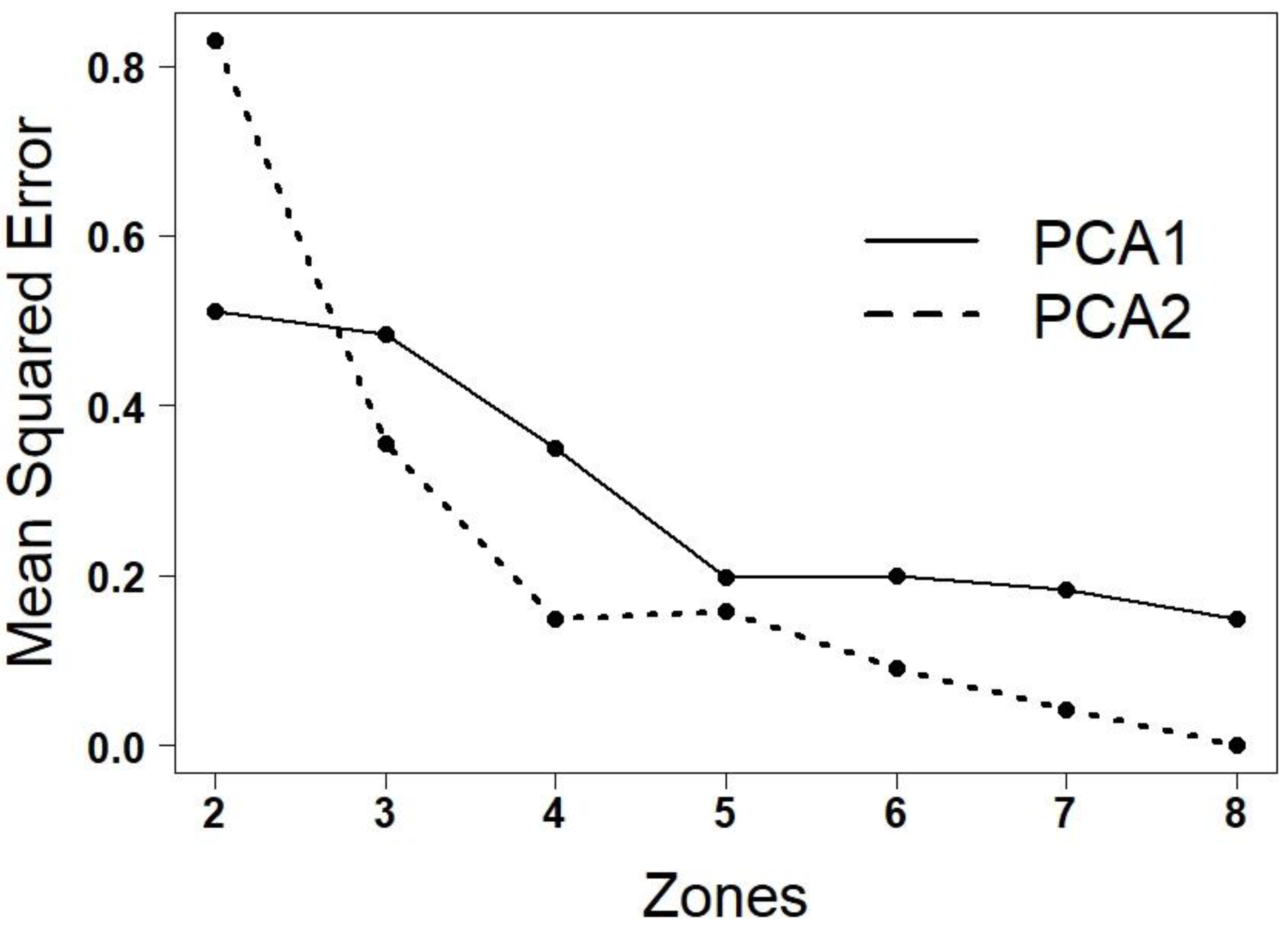
3.1. Number of Management Zones
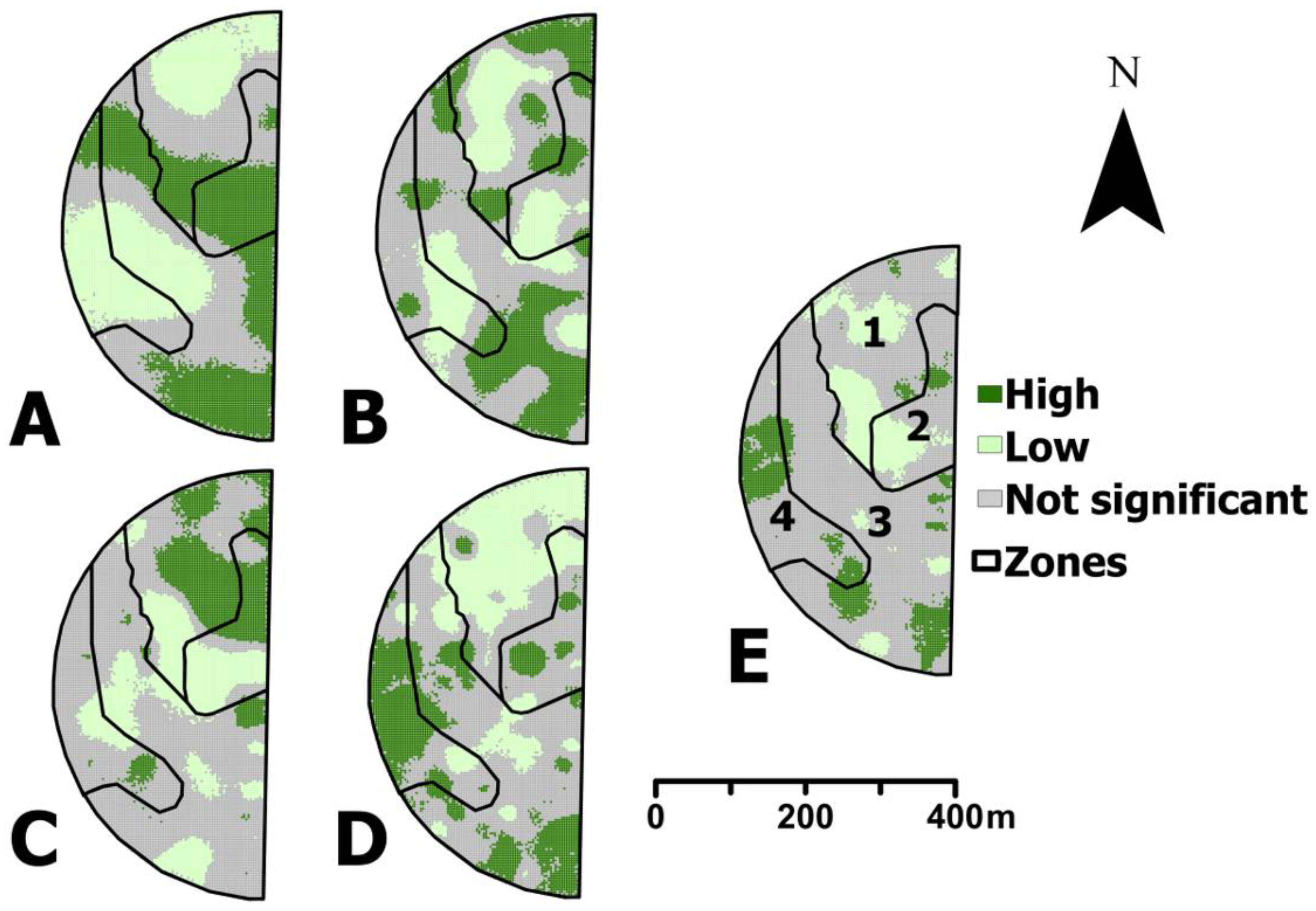
3.2. Variability in Measured Alfalfa Leaf Area Index and Canopy Height
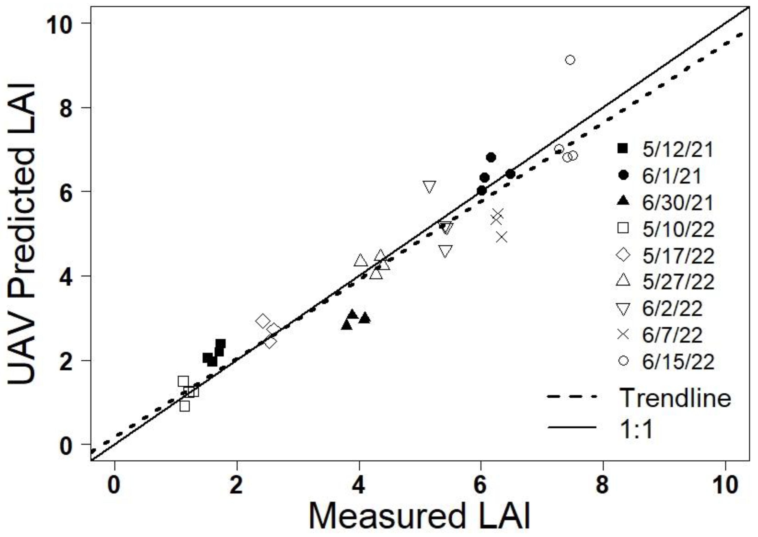
3.3. Evaluation of Visible Vegetation Indices and Height
3.4. Zone Statistical Analysis
4. Discussion
4.1. Spatiotemporal Variability in Measured LAI
4.2. Visible Vegetation Index for Alfalfa Leaf Area Index Estimation
4.3. Translation of UAV Images of the Entire Field
4.4. Limitations and Future Work
4.5. Conclusions
Supplementary Materials
Author Contributions
Funding
Data Availability Statement
Acknowledgments
Conflicts of Interest
References
- Zhao, W.; Li, J.; Yang, R.; Li, Y. Crop Yield and Water Productivity Responses in Management Zones for Variable-Rate Irrigation Based on Available Soil Water Holding Capacity. Trans. ASABE 2017, 60, 1659–1667. [Google Scholar] [CrossRef]
- Chandel, A.K.; Molaei, B.; Khot, L.R.; Peters, R.T.; Stöckle, C.O. High Resolution Geospatial Evapotranspiration Mapping of Irrigated Field Crops Using Multispectral and Thermal Infrared Imagery with METRIC Energy Balance Model. Drones 2020, 4, 52. [Google Scholar] [CrossRef]
- O’Shaughnessy, S.A.; Evett, S.R.; Andrade, A.; Workneh, F.; Price, J.A.; Rush, C.M. Site-Specific Variable Rate Irrigation as a Means to Enhance Water Use Efficiency. In Proceedings of the Irrigation Symposium: Emerging Technologies for Sustainable Irrigation, Long Beach, CA, USA, 10–12 November 2015. [Google Scholar]
- Svedin, J.D.; Kerry, R.; Hansen, N.C.; Hopkins, B.G. Identifying Within-Field Spatial and Temporal Crop Water Stress to Conserve Irrigation Resources with Variable-Rate Irrigation. Agronomy 2021, 11, 1377. [Google Scholar] [CrossRef]
- Hu, Y.; Kang, S.; Ding, R.; Du, T.; Tong, L.; Li, S. The Dynamic Yield Response Factor of Alfalfa Improves the Accuracy of Dual Crop Coefficient Approach under Water and Salt Stress. Water 2020, 12, 1224. [Google Scholar] [CrossRef]
- Chen, W.; Shen, Y.; Robertson, M.; Probert, M.; Bellotti, B.; Nan, Z. Simulation of crop growth and soil water for different cropping systems in the Gansu Loess Plateau, China using APSIM. In Proceedings of the 4th International Crop Science Congress, Brisbane, Australia, 26 September–1 October 2004. [Google Scholar]
- Yang, X.; Brown, H.E.; Texixeira, E.I.; Moot, D.J. Development of a lucerne model in APSIM next generation: 2 canopy expansion and light interception of genotypes with different fall dormancy ratings. Eur. J. Agron. 2022, 139, 126570. [Google Scholar] [CrossRef]
- Dejonge, K.C.; Thorp, K.R. Implementing Standardized Reference Evapotranspiration and Dual Crop Coefficient Approach in the DSSAT Cropping System Model. Trans. ASABE 2017, 60, 1965–1981. [Google Scholar] [CrossRef]
- Irmak, S.; Odhiambo, L.O.; Specht, J.E.; Djaman, K. Hourly and Daily Single and Basal Evapotranspiration Crop Coefficients as a Function of Growing Degree Days, Days After Emergence, Leaf Area Index, Fractional Green Canopy Cover, and Plant Phenology for Soybean. Trans. ASABE 2013, 56, 1785–1803. [Google Scholar] [CrossRef]
- Al-Kaisi, M.; Brun, L.J.; Enz, J.W. Transpiration and evapotranspiration from maize as related to leaf area index. Agric. For. Meteorol. 1989, 48, 111–116. [Google Scholar] [CrossRef]
- Hopkins, A.P. Remote Sensing and Spatial Variability of Leaf Area Index of Irrigated Wheat Fields. Master’s Thesis, Brigham Young University, Provo, UT, USA, 2021. [Google Scholar]
- Kompanizare, M.; Petrone, R.M.; Macrae, M.L.; De Haan, K.; Khomik, M. Assessment of effective LAI and water use efficiency using Eddy Covariance data. Sci. Total Environ. 2022, 802, 149628. [Google Scholar] [CrossRef]
- Walter-Shea, E. Relations between directional spectral vegetation indices and leaf area and absorbed radiation in Alfalfa. Remote Sens. Environ. 1997, 61, 162–177. [Google Scholar] [CrossRef]
- Sharratt, B.S.; Baker, D.G. Alfalfa Leaf Area as a Function of Dry Matter1. Crop Sci. 1986, 26, 1040–1043. [Google Scholar] [CrossRef]
- Al-Gaadi, K.A.; Patil, V.C.; Tola, E.H.M.; Madugundu, R.; Marey, S.A.; Al-Omran, A.M.; Al-Dosari, A. Variable Rate Application Technology for Optimizing Alfalfa Production in Arid Climate. Int. J. Agric. Biol. 2015, 17, 71–79. [Google Scholar]
- Chandel, A.K.; Yu, L.-X. Alfalfa (Medicago sativa L.) crop vigor and yield characterization using high-resolution aerial multispectral and thermal infrared imaging technique. Comput. Electron. Agric. 2021, 182, 105999. [Google Scholar] [CrossRef]
- Kayad, A.G.; Al-Gaadi, K.A.; Tola, E.; Madugundu, R.; Zeyada, A.M.; Kalaitzidis, C. Assessing the Spatial Variability of Alfalfa Yield Using Satellite Imagery and Ground-Based Data. PLoS ONE 2016, 11, e0157166. [Google Scholar] [CrossRef] [PubMed]
- Feng, L.; Zhang, Z.; Ma, Y.; Du, Q.; Williams, P.; Drewry, J.; Luck, B. Alfalfa Yield Prediction Using UAV-Based Hyperspectral Imagery and Ensemble Learning. Remote Sens. 2020, 12, 2028. [Google Scholar] [CrossRef]
- Hu, Q.; Yang, J.; Xu, B.; Huang, J.; Memon, M.S.; Yin, G.; Zeng, Y.; Zhao, J.; Liu, K. Evaluation of Global Decametric-Resolution LAI, FAPAR and FVC Estimates Derived from Sentinel-2 Imagery. Remote Sens. 2020, 12, 912. [Google Scholar] [CrossRef]
- Veroustraete, F. The Rise of the Drones in Agriculture. EC Agric. 2015, 2, 325–327. [Google Scholar]
- Viña, A.; Gitelson, A.A.; Nguy-Robertson, A.L.; Peng, Y. Comparison of different vegetation indices for the remote assessment of green leaf area index of crops. Remote Sens. Environ. 2011, 115, 3468–3478. [Google Scholar] [CrossRef]
- Li, S.; Yuan, F.; Ata-Ui-Karim, S.T.; Zheng, H.; Cheng, T.; Liu, X.; Tian, Y.; Zhu, Y.; Cao, W.; Cao, Q. Combining Color Indices and Textures of UAV-Based Digital Imagery for Rice LAI Estimation. Remote Sens. 2019, 11, 1763. [Google Scholar] [CrossRef]
- Broge, N.H.; Leblanc, E. Comparing prediction power and stability of broadband and hyperspectral vegetation indices for estimation of green leaf area index and canopy chlorophyll density. Remote Sens. Environ. 2000, 76, 156–172. [Google Scholar] [CrossRef]
- Xue, J.; Su, B. Significant Remote Sensing Vegetation Indices: A Review of Developments and Applications. J. Sens. 2017, 2017, 1353691. [Google Scholar] [CrossRef]
- Li, Z. Improved Leaf Area Index Estimation by Considering Both Temporal and Spatial Variations. Master’s Thesis, University of Saskatchewan, Saskatoon, SK, Canada, 2010. [Google Scholar]
- Li, Y.; Su, D. Alfalfa Water Use and Yield under Different Sprinkler Irrigation Regimes in North Arid Regions of China. Sustainability 2017, 9, 1380. [Google Scholar] [CrossRef]
- Grimes, D.W.; Wiley, P.L.; Sheesley, W. Alfalfa yield and plant water relations with variable irrigation. Crop Sci. 1992, 32, 1381–1387. [Google Scholar] [CrossRef]
- Wang, L.; Xie, J.; Luo, Z.; Niu, Y.; Coulter, J.A.; Zhang, R.; Lingling, L. Forage yield, water use efficiency, and soil fertility response to alfalfa growing age in the semiarid Loess Plateau of China. Agric. Water Manag. 2021, 243, 106415. [Google Scholar] [CrossRef]
- Xie, T.; Li, J.; Yang, C.; Jiang, Z.; Chen, Y.; Guo, L.; Zhang, J. Crop height estimation based on UAV images: Methods, errors, and strategies. Comput. Electron. Agric. 2021, 185, 106155. [Google Scholar] [CrossRef]
- Staff, S.S. Web Soil Survey. Available online: http://websoilsurvey.sc.egov.usda.gov/ (accessed on 6 January 2021).
- Kaivosoja, J.; Hautsalo, J.; Heikkinen, J.; Hiltunen, L.; Ruuttunen, P.; Näsi, R.; Niemeläinen, O.; Lemsalu, M.; Honkavaara, E.; Salonen, J. Reference Measurements in Developing UAV Systems for Detecting Pests, Weeds, and Diseases. Remote Sens. 2021, 13, 1238. [Google Scholar] [CrossRef]
- Pittman, J.; Arnall, D.; Interrante, S.; Moffet, C.; Butler, T. Estimation of Biomass and Canopy Height in Bermudagrass, Alfalfa, and Wheat Using Ultrasonic, Laser, and Spectral Sensors. Sensors 2015, 15, 2920–2943. [Google Scholar] [CrossRef]
- Chang, K.-T.; Hsu, W.-L. Estimating Soil Moisture Content Using Unmanned Aerial Vehicles Equipped with Thermal Infrared Sensors. In Proceedings of the IEEE Internation Conference on Applied System Innovation, Chiba, Japan, 13–17 April 2018; pp. 168–171. [Google Scholar]
- Ten Harkel, J.; Bartholomeus, H.; Kooistra, L. Biomass and Crop Height Estimation of Different Crops Using UAV-Based Lidar. Remote Sens. 2019, 12, 17. [Google Scholar] [CrossRef]
- Decagon Devices, Inc. AccuPAR PAR/LAI Ceptometer Model LP-80 Operator’s Manual; METER Group: Pullman, WA, USA, 2013; p. 82. [Google Scholar]
- Atkinson, P.M. Selecting the spatial resolution of airborne MSS imagery for small-scale agricultural mapping. Int. J. Remote Sens. 1997, 18, 1903–1917. [Google Scholar] [CrossRef]
- Kerry, R.; Oliver, M.A. Variograms of Ancillary Data to Aid Sampling for Soil Surveys. Precis. Agric. 2003, 4, 261–278. [Google Scholar] [CrossRef]
- Walthall, C.L.; Pachepsky, Y.; Dulaney, W.P.; Timlin, D.J.; Daughtry, C.S.T. Exploitation of spatial information in high resolution digital imagery to map leaf area index. Precis. Agric. 2007, 8, 311–321. [Google Scholar] [CrossRef]
- Woolley, E. Soil Water Dynamics within Variable Rate Irrigation Zones of Winter Wheat. Master’s Thesis, Brigham Young University, Provo, UT, USA, 2021. [Google Scholar]
- Haghverdi, A.; Leib, B.G.; Washington-Allen, R.A.; Ayers, P.D.; Buschermohle, M.J. Perspectives on delineating management zones for variable rate irrigation. Comput. Electron. Agric. 2015, 117, 154–167. [Google Scholar] [CrossRef]
- Hu, Q.; Mingyao, A. Scale Invariant Feature Transform based matching approach to Unmanned Aerial Vehicles image geo-reference with large rotation angle. In Proceedings of the IEEE International Conference on Spatial Data Mining and Geographical Knowledge Services (ICSDM), Fuzhou, China, 29 June–1 July 2011. [Google Scholar]
- Curran, P.J.; Dawn Williamson, H. Selecting a spatial resolution for estimation of per-field green leaf area index. Int. J. Remote Sens. 1988, 9, 1243–1250. [Google Scholar] [CrossRef]
- Gurjar, S.B.; Padmanabhan, N. Study of various resampling techniques for high-resolution remote sensing imagery. J. Indian Soc. Remote Sens. 2005, 33, 113–120. [Google Scholar] [CrossRef]
- Payero, J.O.; Neale, C.M.U.; Wright, J.L. Comparison of eleven vegetation indices for estimating plant height of alfalfa and grass. Appl. Eng. Agric. 2004, 20, 385–393. [Google Scholar] [CrossRef]
- Mao, W.; Wang, Y.; Wang, Y. Real-Time Detection of Between-Row Weeds Using Machine Vision; American Society of Agricultural and Biological Engineers: St. Joseph, MI, USA, 2003. [Google Scholar]
- Woebbecke, D.M.; Meyer, G.E.; Von Bargen, K.; Mortensen, D.A. Color Indices for Weed Identification Under Various Soil, Residue, and Lighting Conditions. Trans. ASAE 1995, 38, 259–269. [Google Scholar] [CrossRef]
- Meyer, G.E.; Neto, J.C. Verification of color vegetation indices for automated crop imaging applications. Comput. Electron. Agric. 2008, 63, 282–293. [Google Scholar] [CrossRef]
- Camargo Neto, J. A Combined Statistical-Soft Computing Approach for Classification and Mapping Weed Species in Minimum -Tillage Systems. Ph.D. Thesis, The University of Nebraska-Lincoln, Ann Arbor, MI, USA, 2004. [Google Scholar]
- Louhaichi, M.; Borman, M.M.; Johnson, D.E. Spatially Located Platform and Aerial Photography for Documentation of Grazing Impacts on Wheat. Geocarto Int. 2001, 16, 65–70. [Google Scholar] [CrossRef]
- Kawashima, S.; Nakatani, M. An Algorithm for Estimating Chlorophyll Content in Leaves Using a Video Camera. Ann. Bot. 1998, 81, 49–54. [Google Scholar] [CrossRef]
- Tucker, C.J. Red and photographic infrared linear combinations for monitoring vegetation. Remote Sens. Environ. 1979, 8, 127–150. [Google Scholar] [CrossRef]
- Bendig, J.; Yu, K.; Aasen, H.; Bolten, A.; Bennertz, S.; Broscheit, J.; Gnyp, M.L.; Bareth, G. Combining UAV-based plant height from crop surface models, visible, and near infrared vegetation indices for biomass monitoring in barley. Int. J. Appl. Earth Obs. Geoinf. 2015, 39, 79–87. [Google Scholar] [CrossRef]
- Gitelson, A.A.; Gritz, Y.; Merzlyak, M.N. Relationships between leaf chlorophyll content and spectral reflectance and algorithms for non-destructive chlorophyll assessment in higher plant leaves. J. Plant Physiol. 2003, 160, 271–282. [Google Scholar] [CrossRef] [PubMed]
- Alam, A.; Yamamoto, S.; Kahn, N.; Honna, T. Screening for agronomic performance of six indigenous cultivars of alfalfa (Medicago sativa) at Karina northern areas of Pakistan. Electron. J. Environ. Agric. Food Chem. 2009, 8, 950–968. [Google Scholar]
- Xie, Q.; Dash, J.; Huang, W.; Peng, D.; Qin, Q.; Mortimer, H.; Casa, R.; Pignatti, S.; Laneve, G.; Pascucci, S.; et al. Vegetation Indices Combining the Red and Red-Edge Spectral Information for Leaf Area Index Retrieval. IEEE J. Sel. Top. Appl. Earth Obs. Remote Sens. 2018, 11, 1482–1493. [Google Scholar] [CrossRef]
- Howell, R.G.; Jensen, R.R.; Petersen, S.L.; Larsen, R.T. Measuring Height Characteristics of Sagebrush (Artemisia sp.) Using Imagery Derived from Small Unmanned Aerial Systems (sUAS). Drones 2020, 4, 6. [Google Scholar] [CrossRef]
- Wallace, L.; Lucieer, A.; Malenovský, Z.; Turner, D.; Vopěnka, P. Assessment of Forest Structure Using Two UAV Techniques: A Comparison of Airborne Laser Scanning and Structure from Motion (SfM) Point Clouds. Forests 2016, 7, 62. [Google Scholar] [CrossRef]
- Mirvakhabova, L.; Pukalchik, M.; Matveev, S.; Pregubova, P.; Oseledets, I. Field heterogeneity detection based on the modified FastICA RGB-image processing. J. Phys. Conf. Ser. 2018, 1117, 012009. [Google Scholar] [CrossRef]
- Svedin, J.D. Characterizing the Spatial Variation of Crop Water Productivity for Variable-Rate Irrigation Management. Master’s Thesis, Brigham Young University, Provo, UT, USA, 2018. [Google Scholar]
- Hedley, C.B.; Yule, I.J.; Tuohy, M.P.; Vogeler, I. Key performance indicators for simulated variable-rate irrigation of variable soils in humid regions. Trans. ASABE 2009, 52, 1575–1584. [Google Scholar] [CrossRef]

| Date of UAV Flight, the LAI, and Height Measurements | Harvest Interval | Days Prior to Harvest |
|---|---|---|
| 12 May 2021 | 1 | 27 |
| 1 June 2021 | 1 | 7 |
| 29 June 2021 | 2 | 16 |
| 10 May 2022 | 1 | 37 |
| 17 May 2022 | 1 | 30 |
| 27 May 2022 | 1 | 20 |
| 2 June 2022 | 1 | 13 |
| 7 June 2022 | 1 | 8 |
| 15 June 2022 | 1 | 1 |
| VVI | Name | Formula | Citation |
|---|---|---|---|
| ExB | Excess Blue Vegetation Index | ExB = 1.4 B − G | [45] |
| ExG | Excess Green Vegetation Index | ExG = 2 G − R − B | [46] |
| ExR | Excess Red Vegetation Index | ExR = 1.4 R − G | [47] |
| ExGR | Excess Green Minus Excess Red Vegetation Index | ExGR = ExG − ExR | [48] |
| GLI | Green Leaf Index | GLI = (2 G − R − B)/(2 G + R + B) | [49] |
| IKAW | Kawashima Index | IKAW = (R − B)/(R + B) | [50] |
| MGRVI | Modified Green–Red Vegetation Index | MGRVI = (G2 − R2)/(G2 + R2) | [51] |
| NGRDI | Normalized Green–Red Difference Index | NGRDI = (G − R)/(G + R) | [51] |
| RGBVI | Red–Green–Blue Vegetation Index | RGBVI = (G2 − B × R)/(G2 + B × R) | [52] |
| VARI | Visible Atmospherically Resistant Index | VARI = (G − R)/(G + R + B) | [53] |
| WI | Woebbecke Index | WI = (G − B)/(R − G) | [46] |
| Date | Leaf Area Index (m2 m−2) | Alfalfa Canopy Height (cm) | ||||||
|---|---|---|---|---|---|---|---|---|
| Min | Max | Mean | Std. Dev. | Min | Max | Mean | Std. Dev. | |
| 12 May 2021 | 0.23 | 3.42 | 1.93 | 0.51 | 16 | 25 | 20 | 1.96 |
| 1 June 2021 | 4.42 | 7.86 | 6.6 | 0.69 | 34 | 60 | 51 | 4.06 |
| 29 June 2021 | 1.88 | 4.84 | 3.21 | 0.62 | 26 | 50 | 37 | 5.29 |
| 10 May 2022 | 0.36 | 2.11 | 1.2 | 0.32 | 6 | 18 | 14 | 2.19 |
| 17 May 2022 | 0.67 | 4.29 | 2.63 | 0.77 | 11 | 26 | 20 | 2.85 |
| 27 May 2022 | 2.57 | 6.07 | 4.12 | 0.7 | 20 | 39 | 32 | 4.09 |
| 2 June 2022 | 3.39 | 7.07 | 5.01 | 0.81 | 27 | 48 | 39 | 5.14 |
| 7 June 2022 | 3.08 | 8.56 | 5.54 | 1.27 | 36 | 58 | 48 | 5.82 |
| 15 June 2022 | 4.7 | 11.28 | 7.66 | 1.56 | 46 | 65 | 57 | 4.28 |
| 12/5/21 | 1/6/21 | 29/6/21 | 10/5/22 | 17/5/22 | 27/5/22 | 2/6/22 | 7/6/22 | 15/6/22 | |
|---|---|---|---|---|---|---|---|---|---|
| Moran’s value | 0.994 | 0.975 | 0.998 | 0.980 | 0.973 | 0.988 | 0.978 | 0.993 | 0.957 |
| p-value | <0.001 | <0.001 | <0.001 | <0.001 | <0.001 | <0.001 | <0.001 | <0.001 | <0.001 |
| VVI | Model Development | Model Validation | |||
|---|---|---|---|---|---|
| Model Equation | R2 | RMSE | RE | NOF | |
| Models excluding average canopy height | |||||
| ExGR | LAI = 0.08 × ExGR − 3.91 | 0.53 | 1.51 | 1.56 | 0.36 |
| ExR | LAI = −0.11 × ExR + 5.20 | 0.39 | 1.63 | 0.52 | 0.39 |
| MGRVI | LAI = 16.57 × MGRVI − 0.21 | 0.35 | 1.68 | −0.36 | 0.40 |
| NGRDI | LAI = 31.36 × NGRDI − 0.08 | 0.35 | 1.68 | −0.45 | 0.40 |
| Models including average canopy height | |||||
| MGRVI | LAI = 5.70 × MGRVI + 0.13 × avgh − 1.80 | 0.94 | 0.67 | 0.39 | 0.16 |
| NGRDI | LAI = 10.77 × NGRDI + 0.13 × avgh − 1.76 | 0.94 | 0.67 | 0.19 | 0.16 |
| ExR | LAI = −0.04 × ExR + 0.13 × avgh + 0.08 | 0.94 | 0.69 | 0.69 | 0.16 |
| ExGR | LAI = 0.02 × ExGR + 0.13 × avgh − 1.80 | 0.92 | 1.01 | 13.08 | 0.24 |
| Management Zone | Field Mean | ||||
|---|---|---|---|---|---|
| 1 | 2 | 3 | 4 | ||
| 12 May 2021 | |||||
| Estimated LAI m2 m−2 | 1.49 bd | 1.66 ac | 1.49 bd | 1.65 ac | 1.57 |
| % difference from mean | −5 | 6 | −5 | 5 | - |
| 1 June 2021 | |||||
| Estimated LAI m2 m−2 | 6.22 d | 6.28 d | 6.18 d | 6.07 abc | 6.19 |
| % difference from mean | 0 | 1 | 0 | −2 | - |
| 29 June 2021 | |||||
| Estimated LAI m2 m−2 | 3.96 bcd | 3.79 acd | 4.06 ab | 4.14 ab | 3.99 |
| % difference from mean | −1 | −5 | 2 | 4 | - |
| 10 May 2022 | |||||
| Estimated LAI m2 m−2 | 1.19 d | 1.29 | 1.21 d | 1.35 ac | 1.26 |
| % difference from mean | −6 | 3 | −4 | 7 | - |
| 17 May 2022 | |||||
| Estimated LAI m2 m−2 | 2.30 cd | 2.39 d | 2.45 a | 2.52 ab | 2.42 |
| % difference from mean | −5 | −1 | 1 | 4 | - |
| 27 May 2022 | |||||
| Estimated LAI m2 m−2 | 4.29 d | 4.37 | 4.33 d | 4.42 ac | 4.36 |
| % difference from mean | −2 | 0 | −1 | 1 | - |
| 2 June 2022 | |||||
| Estimated LAI m2 m−2 | 7.13 bcd | 6.92 ad | 6.91 ad | 7.22 abc | 7.05 |
| % difference from mean | 1 | −2 | −2 | 2 | - |
| 7 June 2022 | |||||
| Estimated LAI m2 m−2 | 6.43 bcd | 6.29 a | 6.22 a | 6.26 a | 6.30 |
| % difference from mean | 2 | 0 | −1 | −1 | - |
| 15 June 2022 | |||||
| Estimated LAI m2 m−2 | 7.48 d | 7.45 d | 7.47 d | 7.54 abc | 7.48 |
| % difference from mean | 0 | 0 | 0 | 1 | - |
Disclaimer/Publisher’s Note: The statements, opinions and data contained in all publications are solely those of the individual author(s) and contributor(s) and not of MDPI and/or the editor(s). MDPI and/or the editor(s) disclaim responsibility for any injury to people or property resulting from any ideas, methods, instructions or products referred to in the content. |
© 2023 by the authors. Licensee MDPI, Basel, Switzerland. This article is an open access article distributed under the terms and conditions of the Creative Commons Attribution (CC BY) license (https://creativecommons.org/licenses/by/4.0/).
Share and Cite
Hammond, K.; Kerry, R.; Jensen, R.R.; Spackman, R.; Hulet, A.; Hopkins, B.G.; Yost, M.A.; Hopkins, A.P.; Hansen, N.C. Assessing Within-Field Variation in Alfalfa Leaf Area Index Using UAV Visible Vegetation Indices. Agronomy 2023, 13, 1289. https://doi.org/10.3390/agronomy13051289
Hammond K, Kerry R, Jensen RR, Spackman R, Hulet A, Hopkins BG, Yost MA, Hopkins AP, Hansen NC. Assessing Within-Field Variation in Alfalfa Leaf Area Index Using UAV Visible Vegetation Indices. Agronomy. 2023; 13(5):1289. https://doi.org/10.3390/agronomy13051289
Chicago/Turabian StyleHammond, Keegan, Ruth Kerry, Ryan R. Jensen, Ross Spackman, April Hulet, Bryan G. Hopkins, Matt A. Yost, Austin P. Hopkins, and Neil C. Hansen. 2023. "Assessing Within-Field Variation in Alfalfa Leaf Area Index Using UAV Visible Vegetation Indices" Agronomy 13, no. 5: 1289. https://doi.org/10.3390/agronomy13051289
APA StyleHammond, K., Kerry, R., Jensen, R. R., Spackman, R., Hulet, A., Hopkins, B. G., Yost, M. A., Hopkins, A. P., & Hansen, N. C. (2023). Assessing Within-Field Variation in Alfalfa Leaf Area Index Using UAV Visible Vegetation Indices. Agronomy, 13(5), 1289. https://doi.org/10.3390/agronomy13051289


