
Decision Pattern for Changing Polluted Areas into Recreational Places

 ,
, 
Abstract
:1. Introduction
2. Materials and Methods
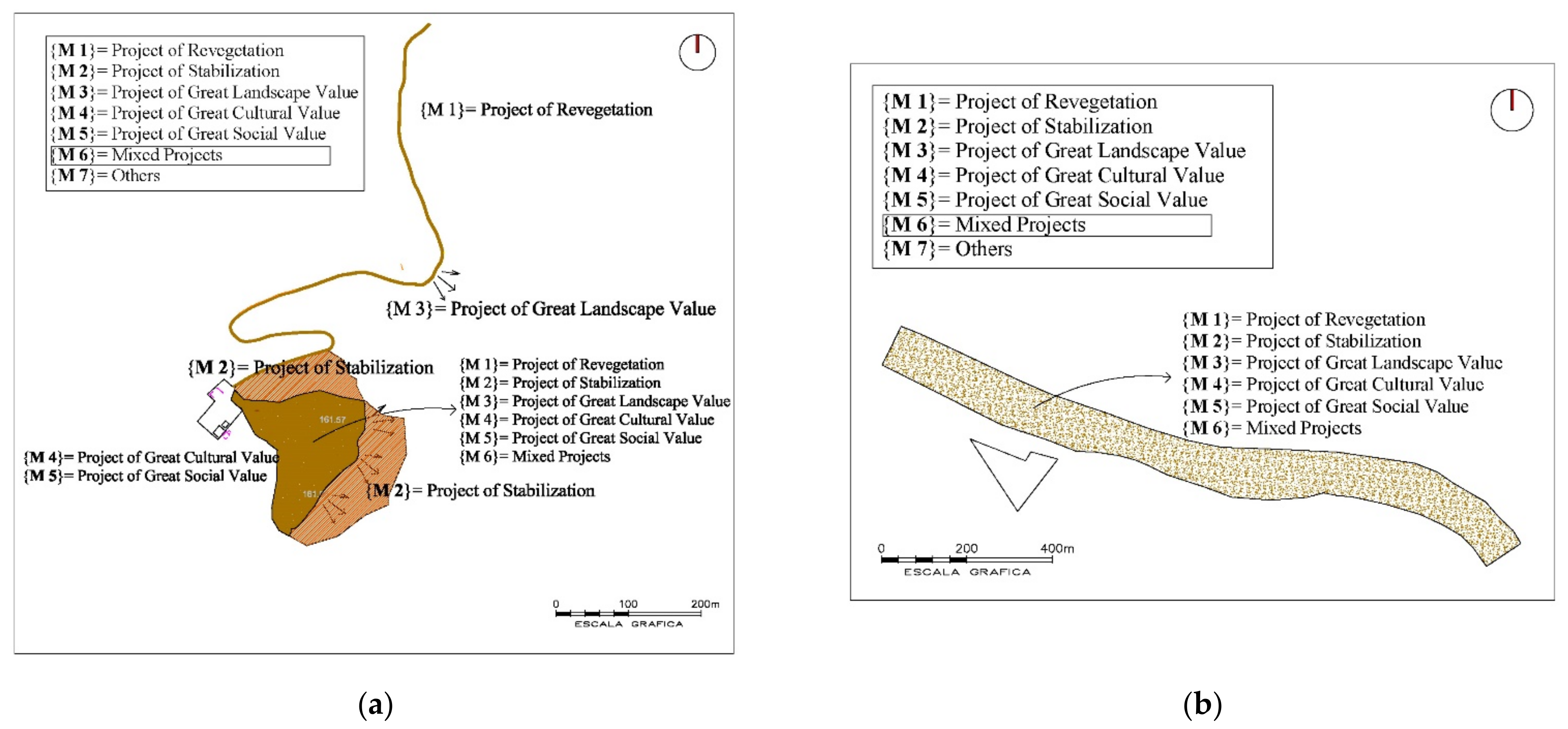
- M1: Revegetation project, only plants would be placed, with aesthetic function.
- M2: Stabilization project, elements (plants, containments, etc.) would be placed to stabilize the soil
- M3: Project of high landscape interest
- M4: Project of high cultural interest.
- M5: High social interest project
- M6: Mixed
- M7: Other projects
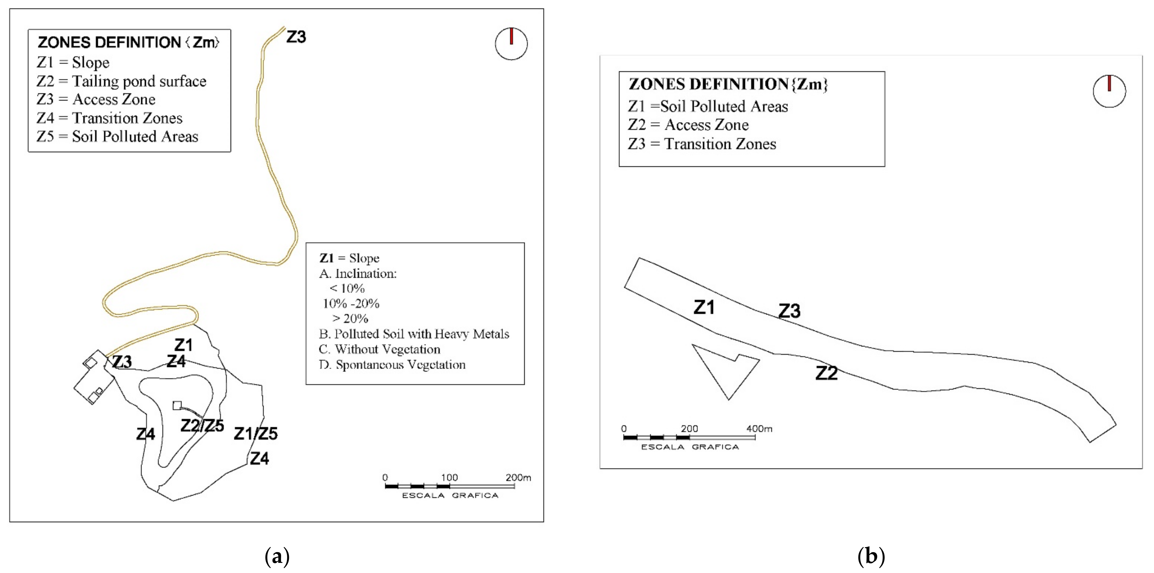
- Z1: Plain
- Z2: Slope
- Z3: Access areas
- Z4: Transition zones
- Z5: Existing trails and recreational areas (viewpoints, etc.)
- Z6: Highly polluted soil areas
- Z7: Existing cultural landmark (castle, interpretation centers, views, etc.)
- Z8: Others
- TP1: Access
- TP2: Parking
- TP3: Transit area
- TP4: Interpretation centers.
- TP5: Cultural landmarks (e.g., castillete, oven, etc.)
- TP6: Thematic milestones (ex: botanical itineraries, etc.)
- TP7: Limited or prohibited access area
- TP8: Slopes
- TP9: Lookouts
- TP10: Footpath
- TP11: Recreation area (e.g., picnic areas, benches, etc.)
- TP12: Existing vegetation areas (trees and bushes)
- TP13: Areas to revegetate
- TP14: Other areas
- Condition pH and immobilize the heavy metal(loid)s present in the contaminated area. This will achieve a reduction in the contamination of nearby waters and soils, as well as a decrease in the transfer of metals to the food chain. By immobilizing metal(loid)s, they are no longer washed with water, nor are they absorbed and retained by vegetation, thereby reducing the risks of transfer of contamination to animals and humans. The soils of the Mediterranean basin are mostly basic, as Mann et al. (2015) [36] show in their work; although the existence of acid soils must also be considered, depending on the rock on which they have been developed and the pluviometry of the area. In order to provide materials that ensure the ecological sustainability of the system, the use of calcium carbonates from remains and washes of marble quarries is suggested for increasing the pH in acid soils [22,37,38]. For the decrease in pH in alkaline soils, more and more acidified or unaltered biochar are used, such as those described in the work of Sadegh-Zadeh et al. (2018) [39].
- Increase the organic matter content to create a soil with good structure (adequate porosity and therefore water retention) and rich in nutrients and microorganisms, to favor the conditions for the establishment of vegetation, as shown in the works of Zornoza et al. (2013) [38] and Parra et al. (2014) [22], which provide animal manure, widely available in Mediterranean areas or the application of effective microorganisms to generate Technosols [40].
3. Results and Discussions
3.1. Development of the Action Model: Study Cases
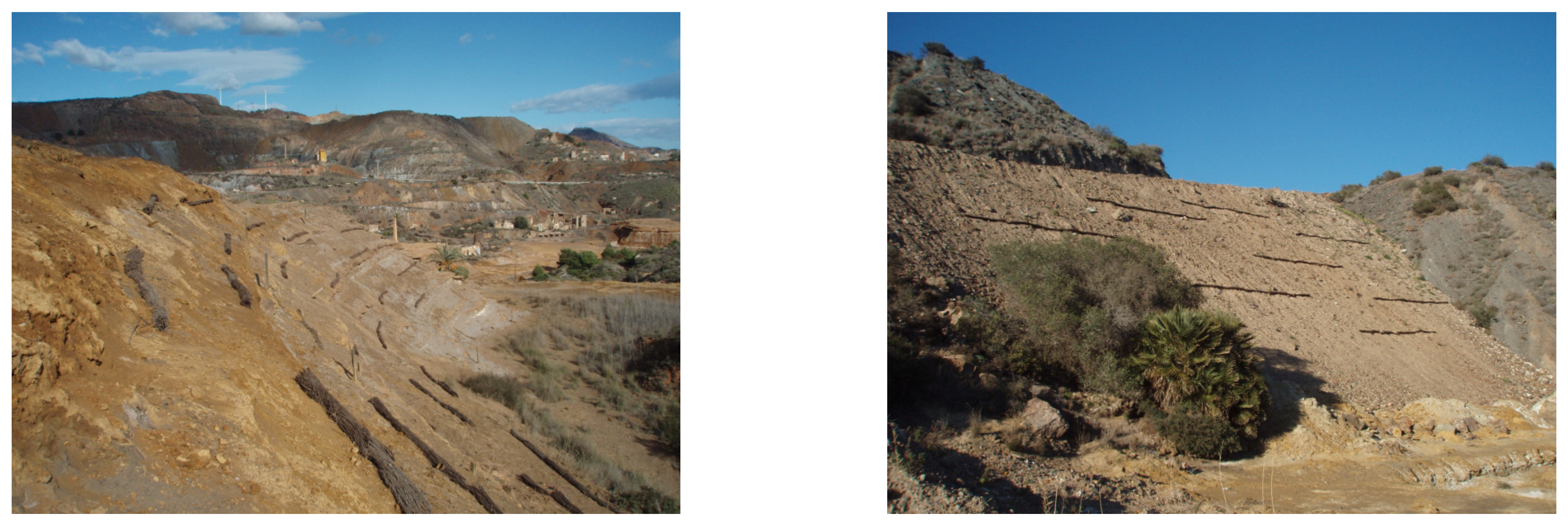
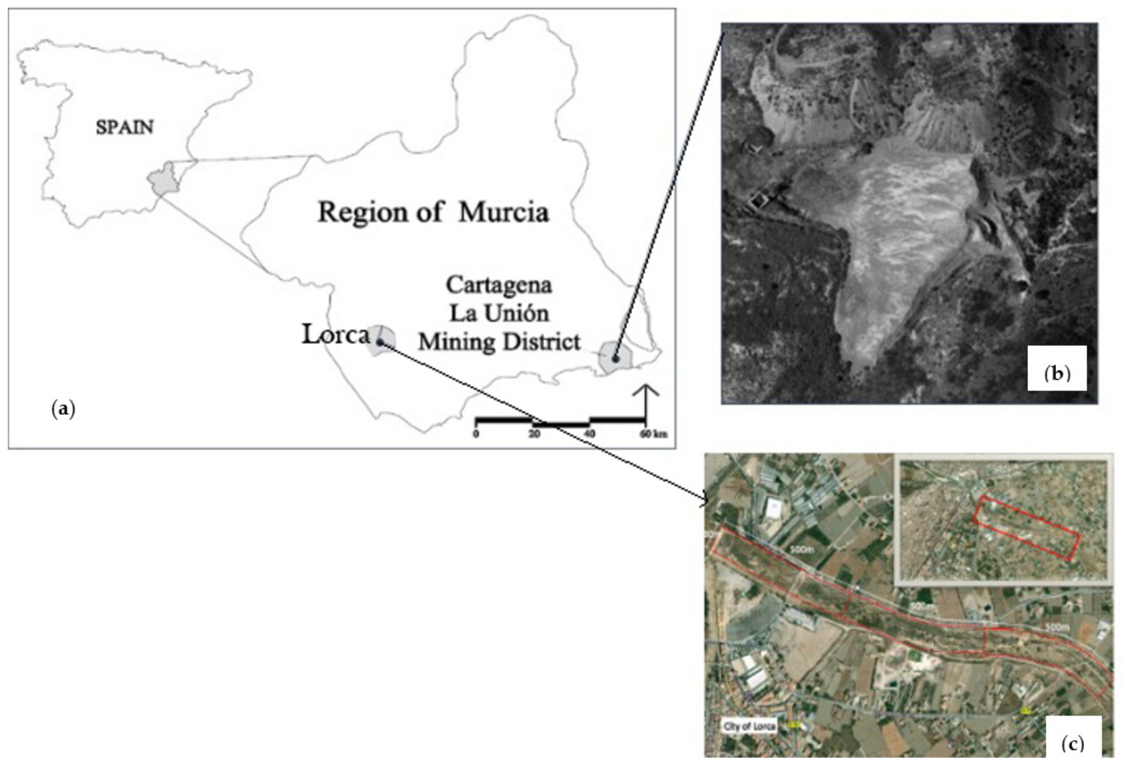
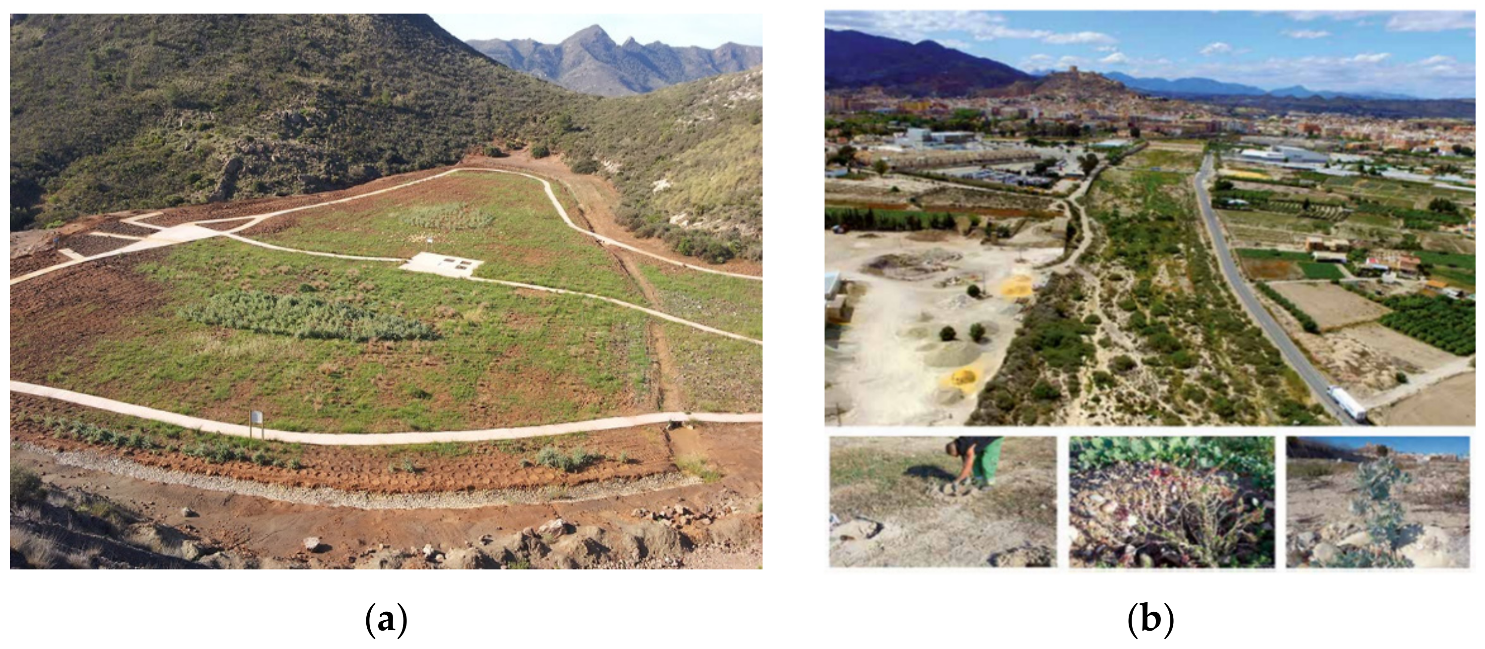
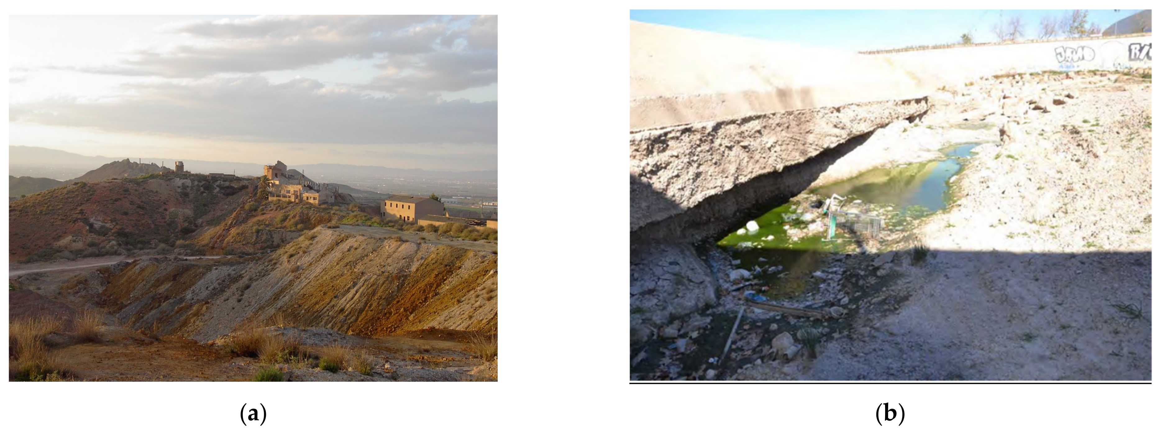
- Case study 1, is an area contaminated by mining activity, the Santa Antonieta mining deposit, which is located to the southeast of the Autonomous Community of the Region of Murcia in the Municipal Term of Cartagena. It is close to population centers, at approximately 4 km from the city of La Unión and 9.5 km from that of Cartagena. Their geographic coordinates are 37°35′38″ N and 0°53′11″ W; it has an altitude of 170 m and an area of 14,095 m2 (Figure 2B).
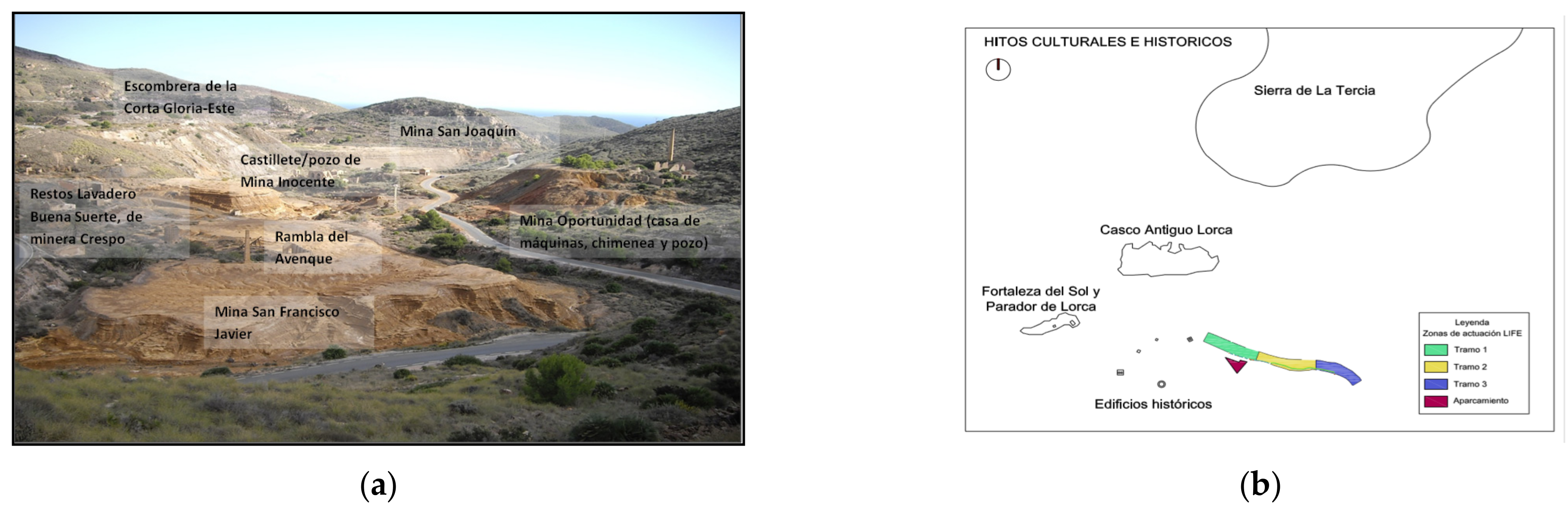
- Case study 2, is an area contaminated by industrial activity, more specifically in the Guadalentín riverbed, as it passes through the municipality of Lorca, where discharges of leather tanning and nearby agricultural production were carried out (Figure 2C). With a total surface of 96,550 m2, located in the geographic coordinates 37°40′32.5″ N 1°41′20.4″ W.
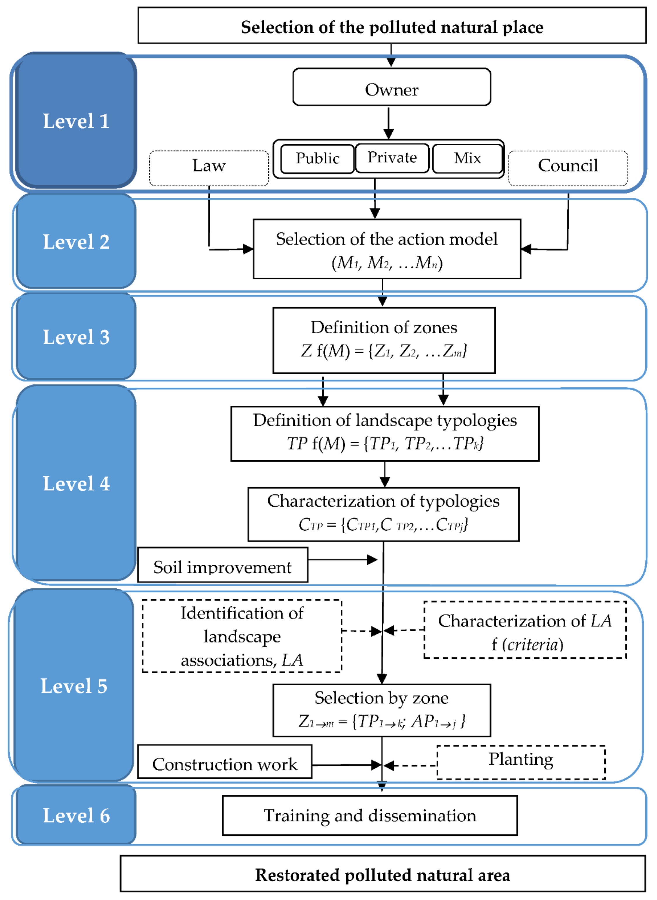
3.2. Level 1: Data Mining
3.2.1. Case Study 1
- Absence of organic matter and nutrients.
- Great compaction of the material and high acidity.
- High concentration of heavy metal(loid)s such as As and high salinity (Table 2).
- Little or no vegetation cover and biodiversity. Although there are very few plants capable of growing in the tank, those that grow can accumulate high contents of heavy metals in their tissues, which can be transferred to the food chain.
- Water and wind erosion, which transport the materials contaminated by heavy metals to other areas (especially to the Rambla del Avenque).
- In the western area of the deposit, the so-called “Acid Mine Drains” are formed, with high acidity, salinity and high content of dissolved metals.
- It is an unstable structure, which ends in a pronounced slope, which favors erosion.
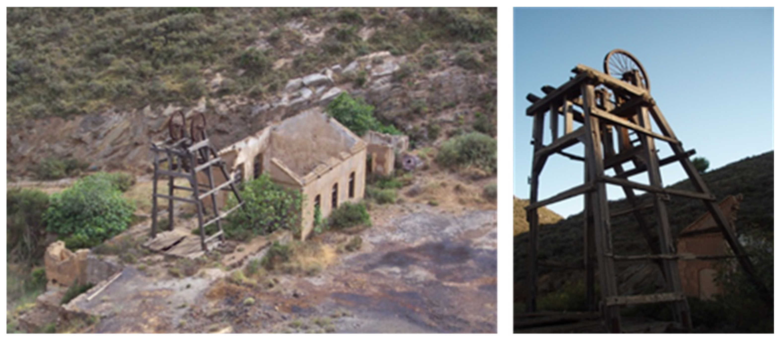
- Loss of the historical-cultural heritage linked to mining; the industrial buildings of the Santa Antonieta deposit are in a state of ruin.
3.2.2. Case Study 2
- Absence of organic matter and nutrients.
- High concentration of heavy metals and salinity (Table 2).
- Water and wind erosion, which transport materials contaminated by heavy metals to other urban areas. The riverbed serves as transportation for polluted waters that in times of torrential rains generate runoff, dragging metals downstream and even into aquifers.
- Danger of having a polluted area within easy reach of children.
3.3. Level 2: Selection of the Action Model
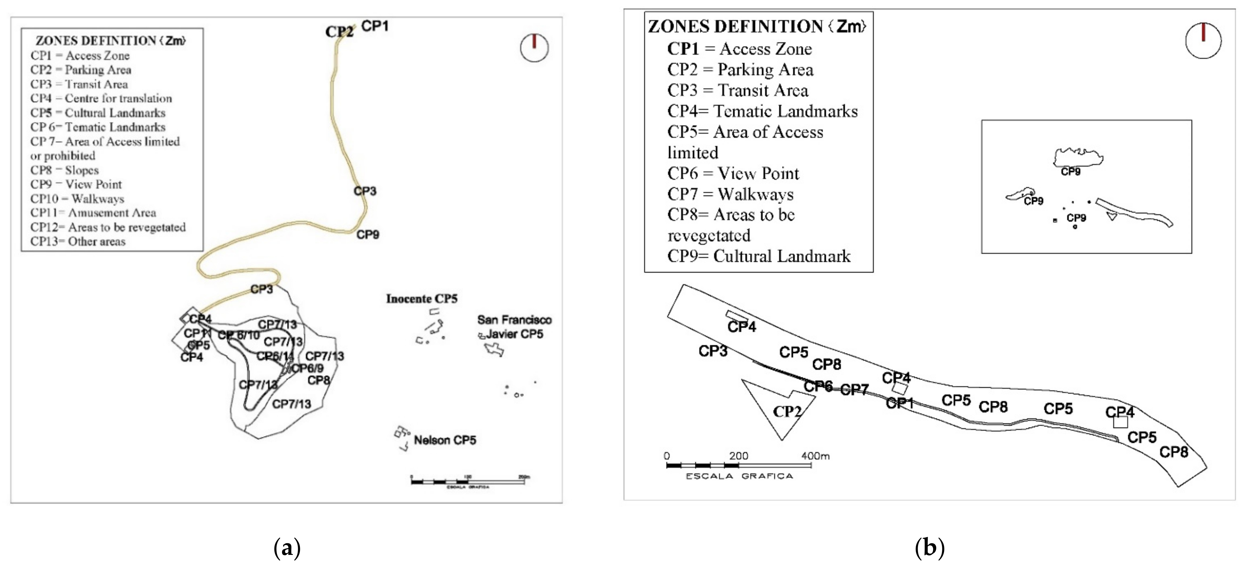
3.4. Level 3: Definition of Zones
3.5. Level 4: Landscape Definition
3.6. Level 5: Characterization and Selection of Species: Construction and Plantation
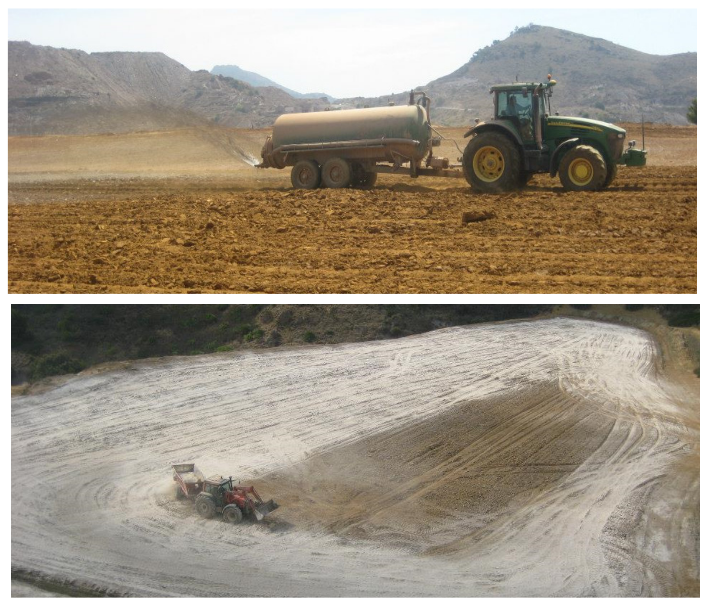
3.6.1. Work Construction
- Access area: this space includes the access road from the N-345 road between La Unión and Portman, which did not exist.
- Network of trails: a network of trails has been designed that fulfills the function of environmental itineraries. This network is made up of a perimeter path and a central one.
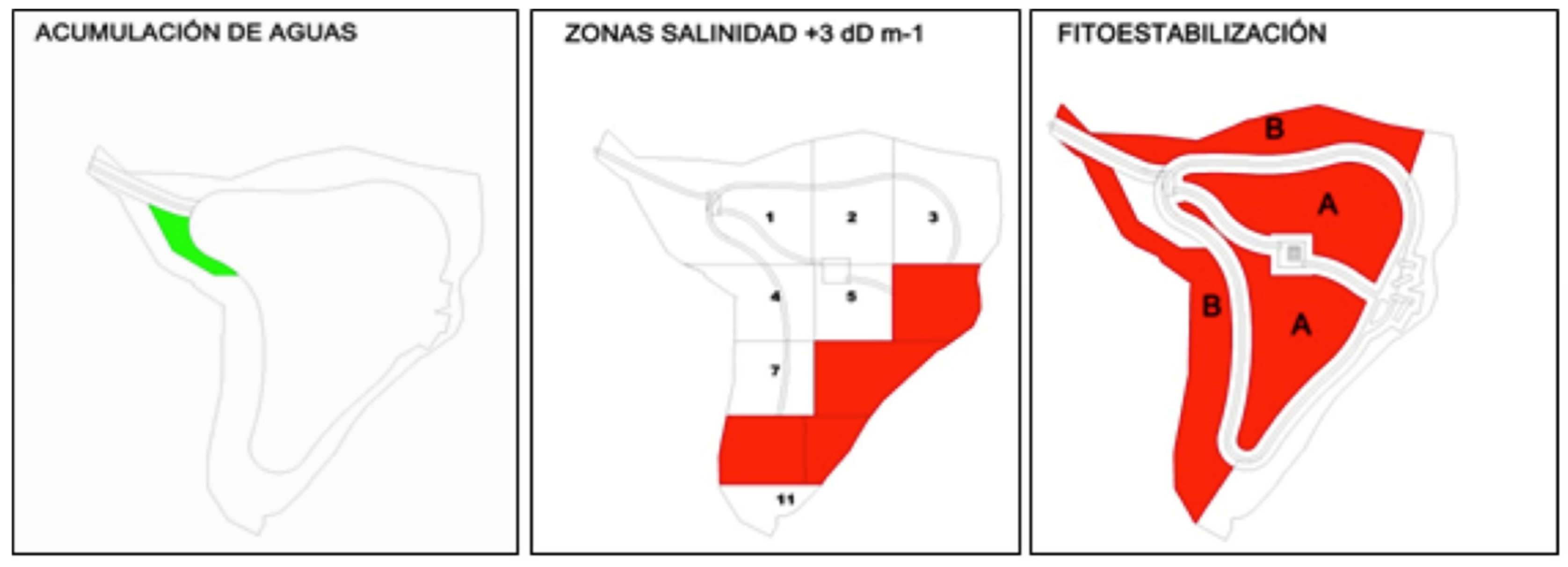
- Draining perimeter ditch, which prevents the accumulation of water in the east and west of the reservoir at the foot of the slopes of the mountains.
- Slope regeneration area: stabilization of the slopes surrounding the reservoir, by placing heather sashes, amendments and plants to stabilize.
3.6.2. Selection of Species by Zone
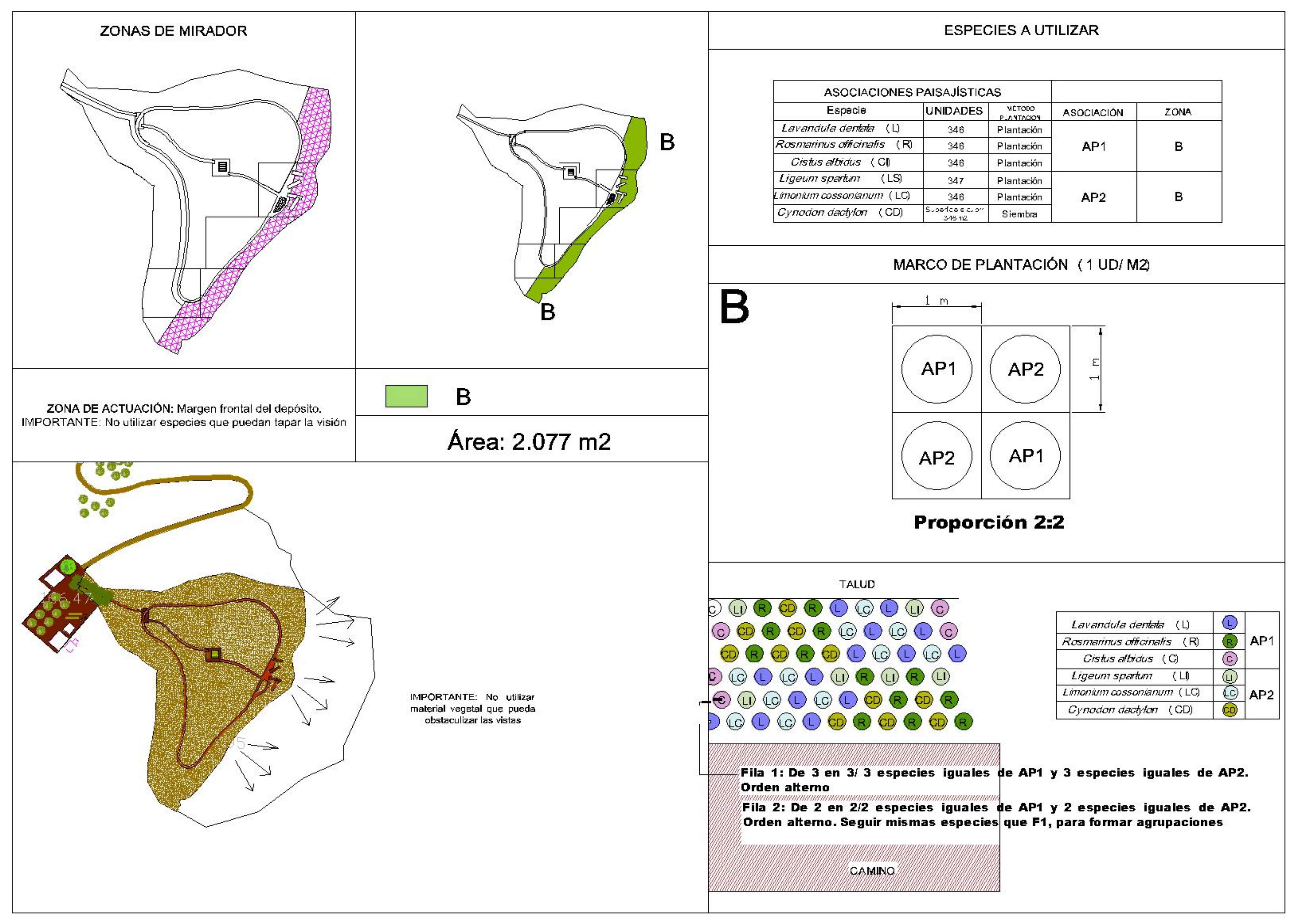
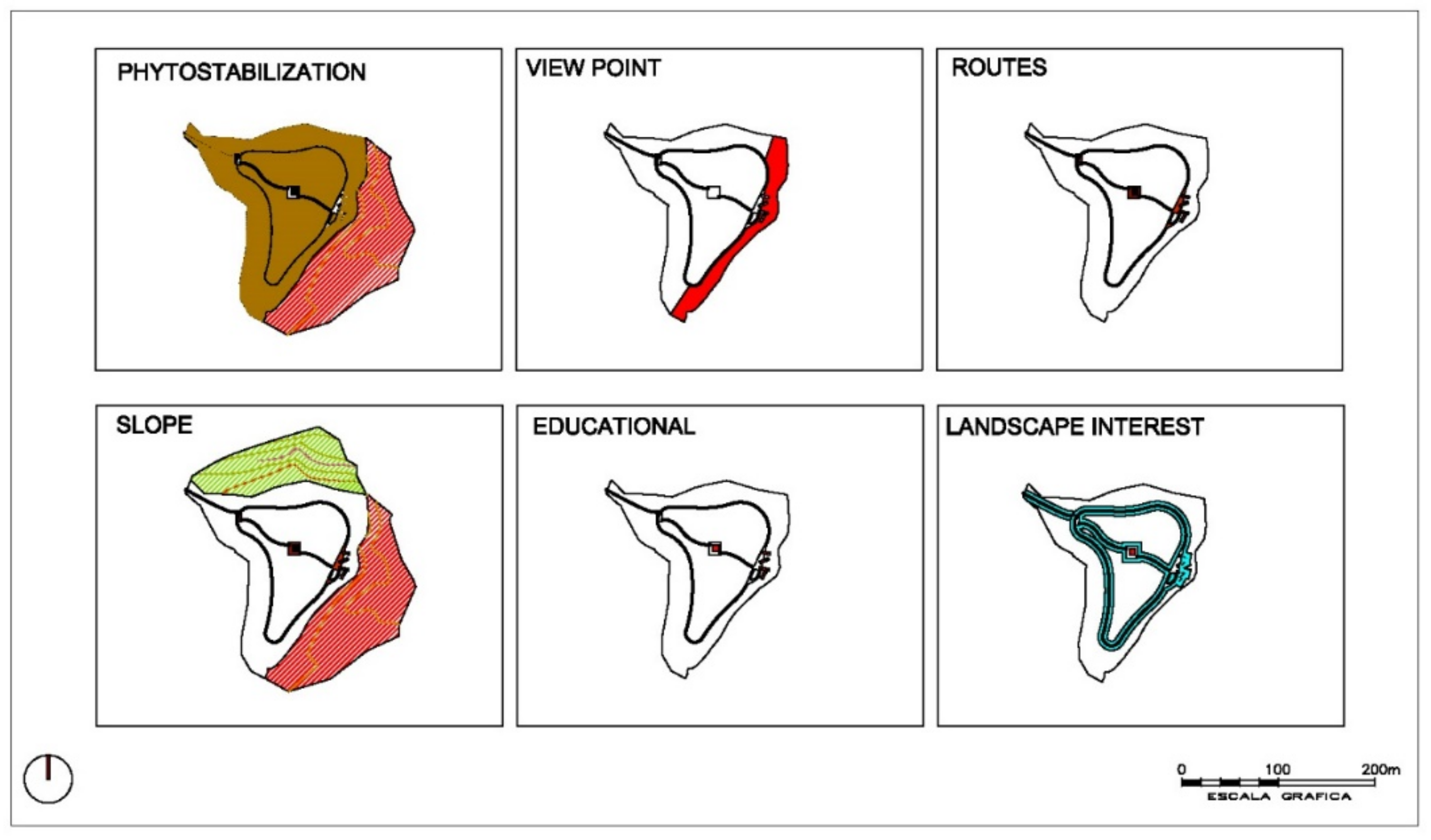
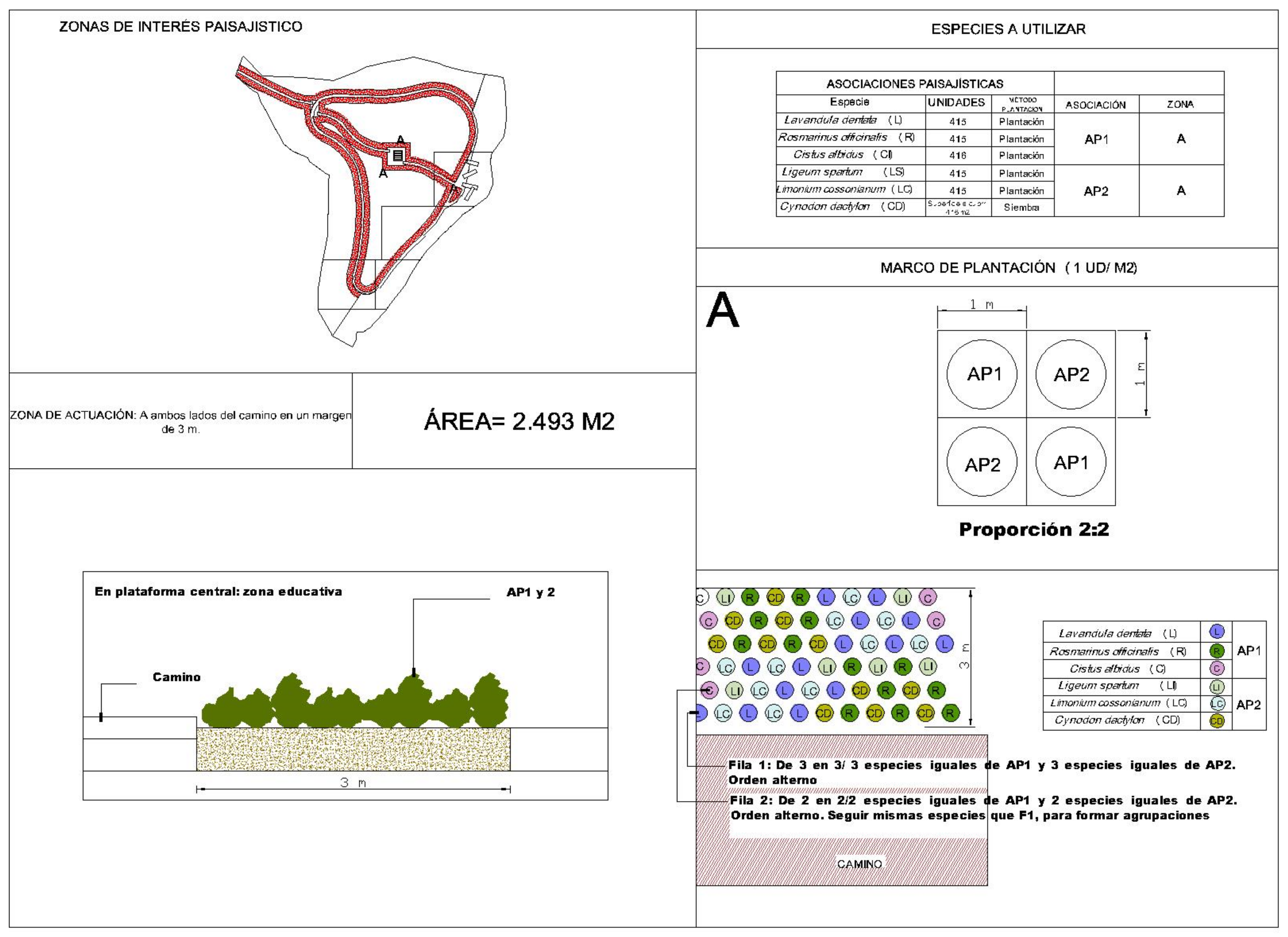
- Zones A and B that surround viewpoints (2077 m2) and a network of trails (2493 m2), in which plant species with landscape interest were selected and whose development did not block views from these points. These being: Lavandula dentada, Rosmarinus officinalis, Cistus albidus, Ligeum spartum and Cynodon dactylon. Seven-hundred and sixty-one units of each species were planted with a planting frame of 1 unit m−2.
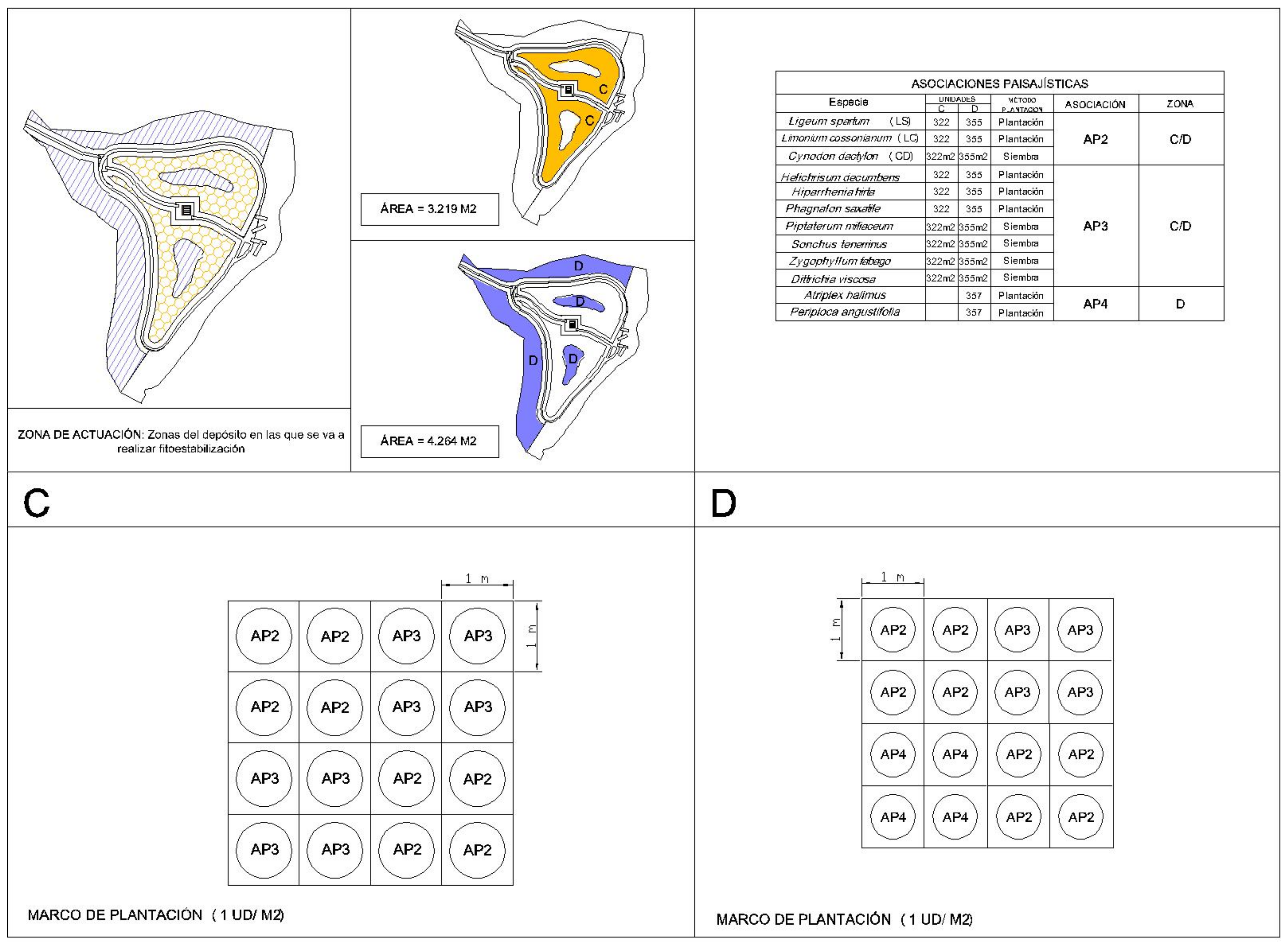
- Central zones C and D of the deposit and surroundings, with high needs for phytostabilization (3219 m2 and 4264 m2), we sought phyto-stabilizing species that had moderate growth in this environment, did not block views and allow us to create landscape-interesting volumes. Atriplex halimus, Ligeum spartum, Helichrysum decumbens, Phagnalon saxatile, Piptatherum miliaceum, Zygophyllum fabago, Dittrichia viscosa and Hyparrhenia hirta were selected. Six-hundred and eighty-seven units of each species have been planted in a planting frame of one plant per m2.
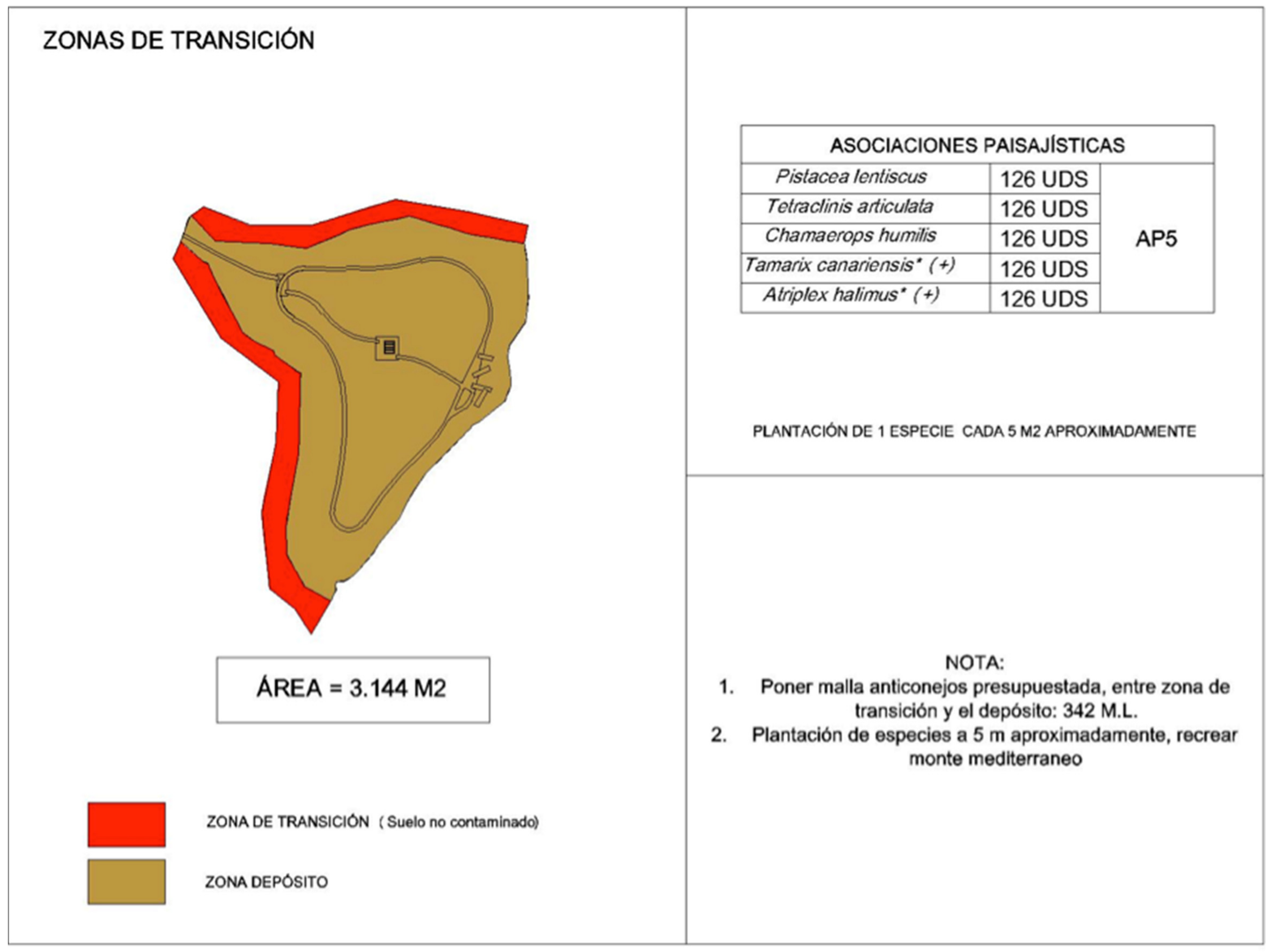
- Transition zones: it includes the zone bordering the mining deposit, with a total area of 3144 m2. Within this unit, plant species with landscape interest have been selected, among which we find the following plant species: Pistacea lentiscus, Tetraclinis articulata, Chamaerops humilis, Tamarix canariensis, Atriplex halimus, 126 units of each species were planted with a planting frame of 1 plant m−2.
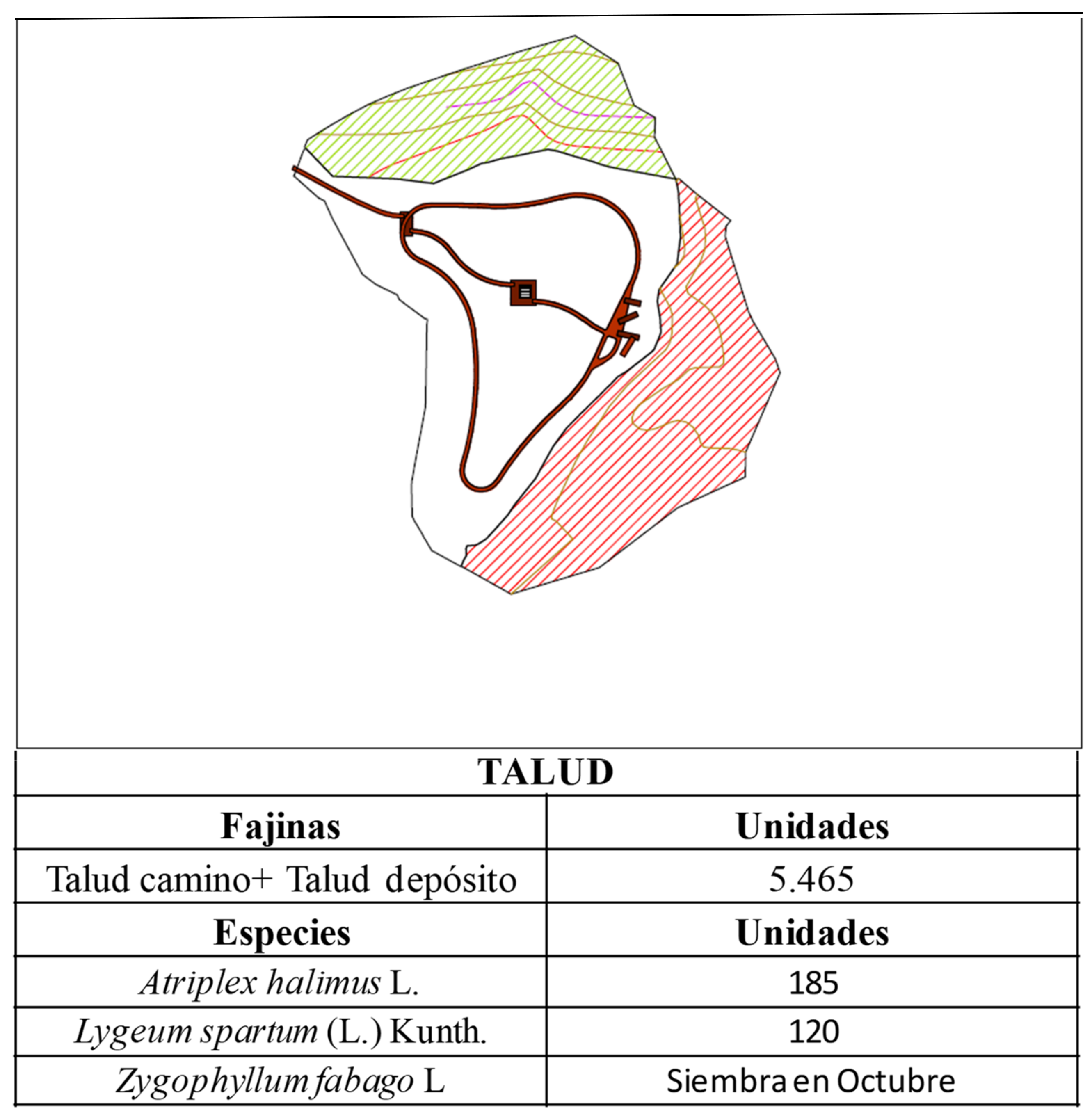
- Slopes regeneration zone with risk of landslides. Five thousand heath sashes and species (Figure A11) with greater root development were placed to give stability: Atriplex halimus, Ligeum spartum, and Zygophyllum fabago. One hundred and twenty units of each species.
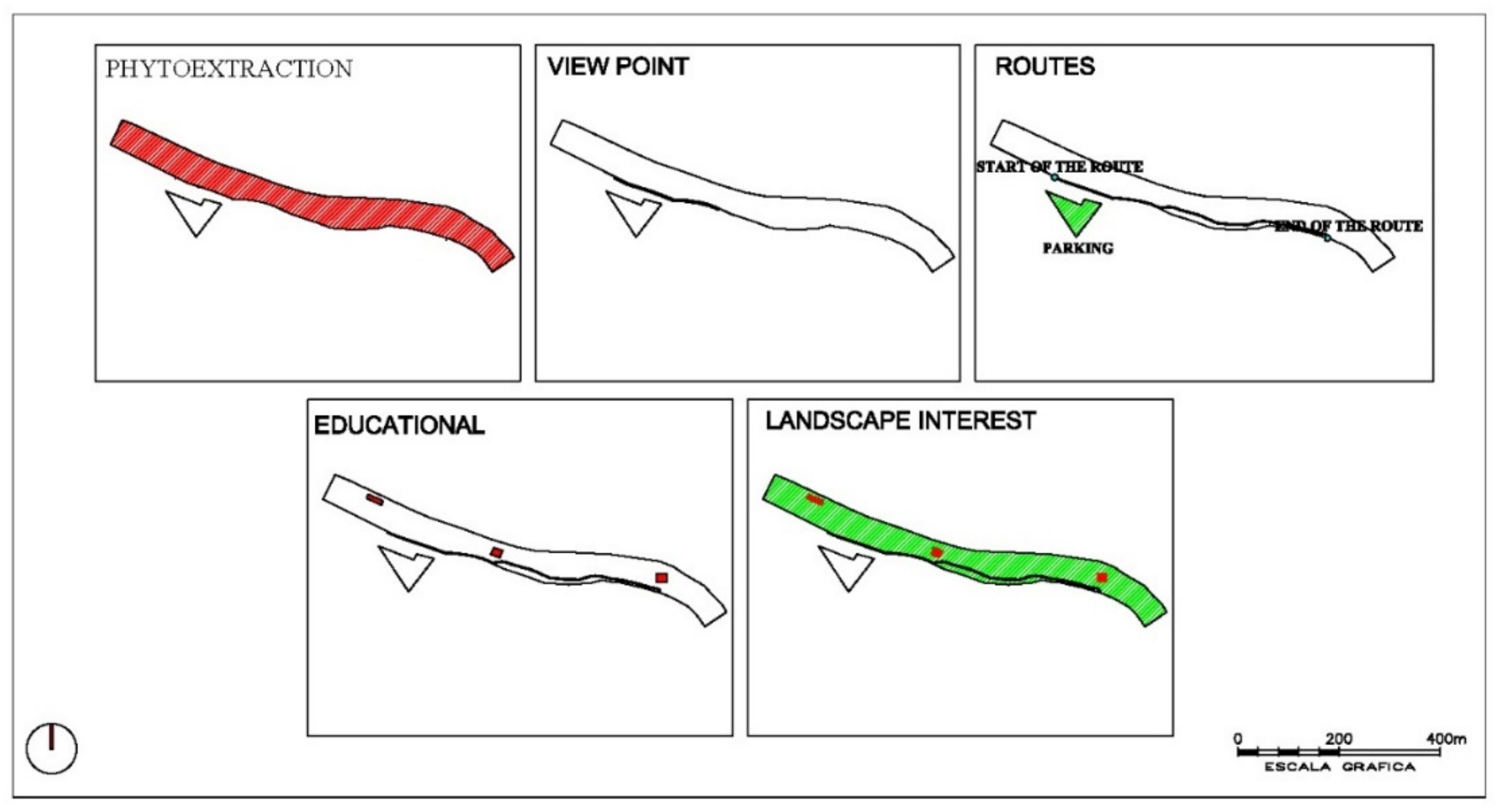
- Riverbed area: 1 plant m−2 plantation. Species: Atriplex halimus; Hyparrhenia sinaica; Lygeum spartum; Piptatherum miliaceum; Salsola oppositifolia; Suaeda vera; Silybum marianum; Tamarix fricana; Dittrichia viscosa; Foeniculum vulgare; Stipa tenacissima; Phagnalon saxatile; Nerium oleander.
- Slope stabilization zone: 1 plant m−2 plantation. Species: Atriplex halimus; Lygeum spartum; Salsola oppositifolia; Suaeda vera; Stipa tenacissima; Nerium oleander; Tamarix fricana.
3.7. Level 6: Definition of End Use
- Three viewpoints, which allow visitors to observe an extraordinary panoramic view of the mining area, being able to compare the regenerated Santa Antonieta mining deposit with other abandoned and degraded deposits.
- A recreational area that coincides with the esplanade where the buildings that constitute the architectural heritage of the deposit are located. From this esplanade the itinerary begins. In this area, the inclusion of urban furniture and shade trees is planned, which will invite the visitor to rest.
- It is planned to define a museum area in order to develop new future economic opportunities, turning the industrial architectural heritage into a museum area for educational use and that serves as a link between nature and human heritage.
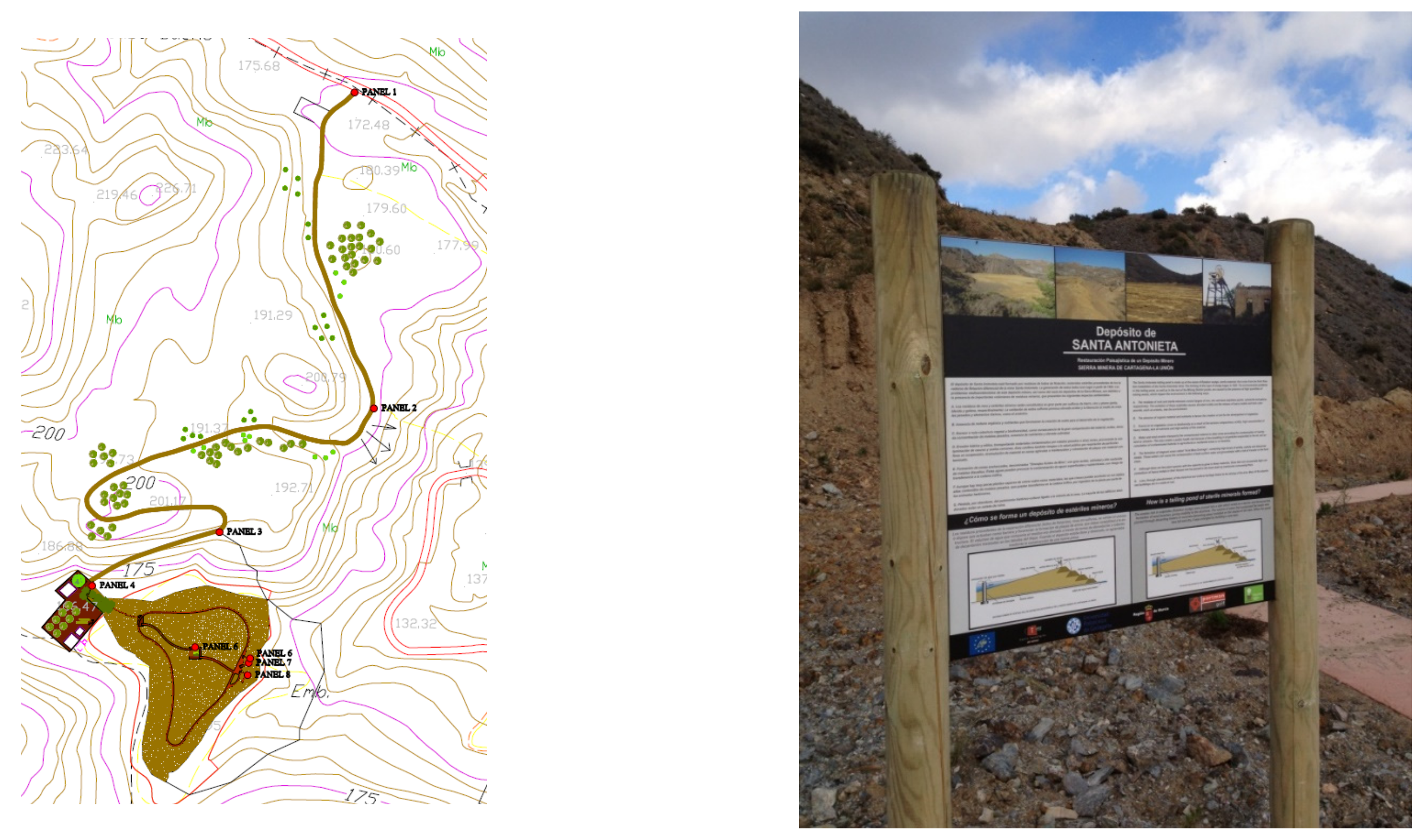
- Panel 1. Brief description of the environmental project, map, regulations for use and precautions, and technical information on the itinerary.
- Panel 2. Overview of Lorca from the performance area. Description of the problem of pollution, its history and origin.
- Panel 3. Description of the techniques used. Results of the actions carried out.
- Panels 4, 5, 6 and 7 (placed at different points on the itinerary). Description of the most representative plant species.
- Panel 8. Biodiversity of the river ecosystem.
- Panel 9. End of route.
4. Conclusions
Author Contributions
Funding
Acknowledgments
Conflicts of Interest
Appendix A


References
- Khalid, S.; Shahid, M.; Niazi, N.K.; Murtaza, B.; Bibi, I.; Dumat, C. A Comparison of Technologies for Remediation of Heavy Metal Contaminated Soils. J. Geochem. Explor. 2017, 182, 247–268. [Google Scholar] [CrossRef] [Green Version]
- Raffa, C.M.; Chiampo, F.; Shanthakumar, S. Remediation of Metal/Metalloid-Polluted Soils: A Short Review. Appl. Sci. 2021, 11, 4134. [Google Scholar] [CrossRef]
- European Union. Directive 2004/35/CE of the European Parliament and of the Council of 21 April 2004 on Environmental Liability with Regard to the Prevention and Remedying of Environmental Damage; OJEU: Brussels, Belgium, 2004. [Google Scholar]
- Hill, M.J.; Braaten, R.; Veitch, S.M.; Lees, B.G.; Sharma, S. Multi-Criteria Decision Analysis in Spatial Decision Support: The ASSESS Analytic Hierarchy Process and the Role of Quantitative Methods and Spatially Explicit Analysis. Environ. Model. Softw. 2005, 20, 955–976. [Google Scholar] [CrossRef]
- Pearlstine, L.; Deangelis, D.L.; Mazzotti, F.J.; Barnes, T.; Duever, M.; Starnes, J. Spatial Decision Support Systems for Landscape Ecological Evaluations in the Southwest Florida Feasibility Study; UF University of Florida: Gainesville, FL, USA, 2004; 4p. [Google Scholar]
- Reynolds, K.M.; Hessburg, P.F. An Overview of the Ecosystem Management Decision-Support System. In Decision Support for Environmental Management: Applications of the Ecosystem Management Decision Support System, 1st ed.; Keith, M., Reynolds, P.F., Eds.; Springer: New York, NY, USA, 2014; pp. 3–22. [Google Scholar]
- Valente, R.A.; de Mello, K.; Metedieri, J.F.; Américo, C. A Multicriteria Evaluation Approach to Set Forest Restoration Priorities Based on Water Ecosystem Services. J. Environ. Manag. 2021, 285, 112049. [Google Scholar] [CrossRef] [PubMed]
- Yu, J.; Yang, R. Study on the Predictive Algorithm of Plant Restoration under Heavy Metals. Hindawi Sci. Program. 2021, 2021, 6193182. [Google Scholar] [CrossRef]
- Hughes, F.M.R.; Adams, W.M.; Butchart, S.H.M.; Field, R.H.; Peh, K.S.H.; Warrington, S. The Challenges of Integrating Biodiversity and Ecosystem Services Monitoring and Evaluation at a Landscape-Scale Wetland Restoration Project in the UK. Ecol. Soc. 2016, 21, 10. [Google Scholar] [CrossRef] [Green Version]
- Leach, K.; Grigg, A.; O′Connor, B.; Brown, C.; Vause, J.; Gheyssens, J.; Weatherdon, L.; Halle, M.; Burgess, N.D.; Fletcher, R.; et al. A Common Framework of Natural Capital Assets for Use in Public and Private Sector Decision Making. Ecosyst. Serv. 2019, 36, 100899. [Google Scholar] [CrossRef]
- Al-Weshah, R.A.; Yihdego, Y. Multi-Criteria Decision Approach for Evaluation, Ranking, and Selection of Remediation Options: Case of Polluted Groundwater, Kuwait. Environ. Sci. Pollut. Res. 2018, 25, 36039–36045. [Google Scholar] [CrossRef] [Green Version]
- Martin, D.M.; Jacobs, A.D.; McLean, C.; Canick, M.R.; Boomer, K. Comparing Normative and Descriptive Methods for Multi-Criteria Decision Analysis: A Case Study Evaluating Wetland Restoration Opportunities in the Chesapeake Bay Watershed, USA. Environ. Sci. Policy 2022, 132, 142–152. [Google Scholar] [CrossRef]
- Chazdon, R.L.; Guariguata, M.R. Decision Support Tools for Forest Landscape Restoration. Current Status and Future Outlook, 1st ed.; Occasional Paper 183; Center for International Forestry Research: Bogor, Indonesia, 2018. [Google Scholar]
- Gomez-Ros, J.M.; Garcia, G.; Peñas, J.M. Assessment of Restoration Success of Former Metal Mining Areas after 30 Years in a Highly Polluted Mediterranean Mining Area: Cartagena-La Unión. Ecol. Eng. 2013, 57, 393–402. [Google Scholar] [CrossRef]
- Wilschut, M.; Theuws, P.A.W.; Duchhart, I. Phytoremediative Urban Design: Transforming a Derelict and Polluted Harbour Area into a Green and Productive Neighbourhood. Environ. Pollut. 2013, 183, 81–88. [Google Scholar] [CrossRef] [PubMed]
- Ruckelshaus, M.; McKenzie, E.; Tallis, H.; Guerry, A.; Daily, G.; Kareiva, P.; Polasky, S.; Ricketts, T.; Bhagabati, N.; Wood, S.A.; et al. Notes from the Field: Lessons Learned from Using Ecosystem Service Approaches to Inform Real-World Decisions. Ecol. Econ. 2015, 115, 11–21. [Google Scholar] [CrossRef] [Green Version]
- Mendez, M.O.; Maier, R.M. Phytostabilization of Mine Tailings in Arid and Semiarid Environments—An Emerging Remediation Technology. Environ. Health Perspect. 2008, 116, 278–283. [Google Scholar] [CrossRef] [PubMed] [Green Version]
- Pathak, L.; Shah, K. Phytoremediation of Abandoned Mining Areas for Land Restoration: Approaches and Technology. In Phytorestoration of Abandoned Mining and Oil Drilling Sites; Bauddh, K., Korstad, J., Sharma, P., Eds.; Elsevier: Amsterdam, The Netherlands, 2021; pp. 33–56. [Google Scholar] [CrossRef]
- Guidi Nissim, W.; Labrecque, M. Reclamation of Urban Brownfields through Phytoremediation: Implications for Building Sustainable and Resilient Towns. Urban For. Urban Green. 2021, 65, 127364. [Google Scholar] [CrossRef]
- Azad Davar, S.; Rostami, P.; Moradi, M.; Planting, M.M. Planting desing utilizing phytorremediation of garden-rangeland ecotypes in urban green space (case study of the new city of Pardis). PalArch′s J. Archeol. Egypt 2021, 18, 547–558. [Google Scholar]
- Ye, Z.H.; Wong, J.W.C.; Wong, M.H.; Lan, C.Y.; Baker, A.J.M. BIORISOUR (I II (IIO/O Y)) Lime and Pig Manure as Ameliorants for Revegetating Lead/Zinc Mine Tailings: A Greenhouse Study. Bioresour. Technol. 1999, 69, 35–43. [Google Scholar] [CrossRef]
- Parra, A.; Zornoza, R.; Conesa, E.; Gómez-López, M.D.; Faz, A. Seedling Emergence, Growth and Trace Elements Tolerance and Accumulation by Lamiaceae Species in a Mine Soil. Chemosphere 2014, 113, 132–140. [Google Scholar] [CrossRef]
- Parra, A.; Zornoza, R.; Conesa, E.; Gómez-López, M.D.; Faz, A. Evaluation of the Suitability of Three Mediterranean Shrub Species for Phytostabilization of Pyritic Mine Soils. Catena 2016, 136, 59–65. [Google Scholar] [CrossRef]
- Parra, A.; Zornoza, R.; Conesa, E.; Faz, A.; Gómez-López, M.D. Nutritional Status and Its Interaction with Soil Properties and Trace Elements in Six Mediterranean Shrub Species Grown in Reclaimed Pyritic Tailings. Ecol. Eng. 2017, 109, 25–34. [Google Scholar] [CrossRef]
- Verma, R.K.; Sankhla, M.S.; Jadhav, E.B.; Parihar, K.; Awasthi, K.K. Phytoremediation of Heavy Metals Extracted from Soil and Aquatic Environments: Current Advances as Well as Emerging Trends. Biointerface Res. Appl. Chem. 2021, 12, 5486–5509. [Google Scholar] [CrossRef]
- Whiting, S.N.; Reeves, R.D.; Richards, D.; Johnson, M.S.; Cooke, J.A.; Malaisse, F.; Paton, A.; Smith, J.A.C.; Angle, J.S.; Chaney, R.L.; et al. Research Priorities for Conservation of Metallophyte Biodiversity and Their Potential for Restoration and Site Remediation. Restor. Ecol. 2004, 12, 106–116. [Google Scholar] [CrossRef] [Green Version]
- La’szlo’Simon, L.L. Stabilization of Metals in Acidic Mine Spoil with Amendments and Red Fescue (Festuca Rubra L.) growth. Environ. Geochem. Health 2005, 27, 289–300. [Google Scholar] [CrossRef]
- Rosales, R.M.; Faz, A.; Gómez-Garrido, M.M.; Muñoz, A.; Murcia, F.J.; González, V.; Acosta, J.A. Geochemical Speciation of Chromium Related to Sediments Properties in the Riverbed Contaminated by Tannery Effluents. Ournal Soils Sediments 2017, 17, 1437–1448. [Google Scholar] [CrossRef]
- Laghlimi, M.; Baghdad, B.; Hadi, H.; Bouabdli, A. Phytoremediation Mechanisms of Heavy Metal Contaminated Soils: A Review. Open J. Ecol. 2015, 5, 375–388. [Google Scholar] [CrossRef] [Green Version]
- Wei, Z.; Van Le, Q.; Peng, W.; Yang, Y.; Yang, H.; Gu, H.; Lam, S.S.; Sonne, C. A Review on Phytoremediation of Contaminants in Air, Water and Soil. J. Hazard. Mater. 2021, 403, 123658. [Google Scholar] [CrossRef]
- Kabas, S. Integration of Landscape Reclamation, Planning and Design in a Post-Mining District: Cartagena-La Union, SE Spain. Ph.D. Thesis, Universidad Politécnica de Cartagena, Cartagena, Spain, 2013. [Google Scholar] [CrossRef] [Green Version]
- Kabas, S.; Faz, A.; Acosta, J.A.; Zornoza, R.; Martínez-Martínez, S.; Carmona, D.M.; Bech, J. Effect of Marble Waste and Pig Slurry on the Growth of Native Vegetation and Heavy Metal Mobility in a Mine Tailing Pond. J. Geochem. Explor. 2012, 123, 69–76. [Google Scholar] [CrossRef]
- Boojar, M.M.A.; Tavakkoli, Z. Antioxidative Responses and Metal Accumulation in Invasive Plant Species Growing on Mine Tailings in Zanjan, Iran. Pedosphere 2011, 21, 802–812. [Google Scholar] [CrossRef]
- Conesa, H.M.; García, G.; Ngel Faz, A.; Arnaldos, R. Dynamics of Metal Tolerant Plant Communities′ Development in Mine Tailings from the Cartagena-La Unión Mining District (SE Spain) and Their Interest for Further Revegetation Purposes. Chemosphere 2007, 68, 1180–1185. [Google Scholar] [CrossRef]
- Parra, A.; Raúl, T.; Belmonte, Z.; Faz, Á.; María, C.; Gómez-López, D.; Adrián, F.; Aguilar, R. Guía de Especies Vegetales de la Cuenca Mediterránea Aptas Para Revegetcaión: Adecuación Para Zonas Degradadas Y Contaminadas; Universidad Politécnica de Cartagena: Cartagena, Spain, 2019; p. 55. [Google Scholar]
- Mann, A.; Reimann, C.; de Caritat, P.; Turner, N.; Birke, M. Mobile Metal Ion® Analysis of European Agricultural Soils: Bioavailability, Weathering, Geogenic Patterns and Anthropogenic Anomalies. Geochem. Explor. Environ. Anal. 2015, 15, 99–112. [Google Scholar] [CrossRef]
- Pardo, T.; Clemente, R.; Bernal, M.P. Effects of Compost, Pig Slurry and Lime on Trace Element Solubility and Toxicity in Two Soils Differently Affected by Mining Activities. Chemosphere 2011, 84, 642–650. [Google Scholar] [CrossRef]
- Zornoza, R.; Faz, Á.; Carmona, D.M.; Acosta, J.A.; Martínez-Martínez, S.; de Vreng, A. Carbon Mineralization, Microbial Activity and Metal Dynamics in Tailing Ponds Amended with Pig Slurry and Marble Waste. Chemosphere 2013, 90, 2606–2613. [Google Scholar] [CrossRef] [PubMed]
- Sadegh-Zadeh, F.; Parichehreh, M.; Jalili, B.; Bahmanyar, M.A. Rehabilitation of Calcareous Saline-sodic Soil by Means of Biochars and Acidified Biochars. Land Degrad. Dev. 2018, 29, 3262–3271. [Google Scholar] [CrossRef]
- Zornoza, R.; Gómez-Garrido, M.; Martínez-Martínez, S.; Gómez-López, M.D.; Faz, Á. Bioaugmentaton in Technosols Created in Abandoned Pyritic Tailings Can Contribute to Enhance Soil C Sequestration and Plant Colonization. Sci. Total Environ. 2017, 593, 357–367. [Google Scholar] [CrossRef] [PubMed]
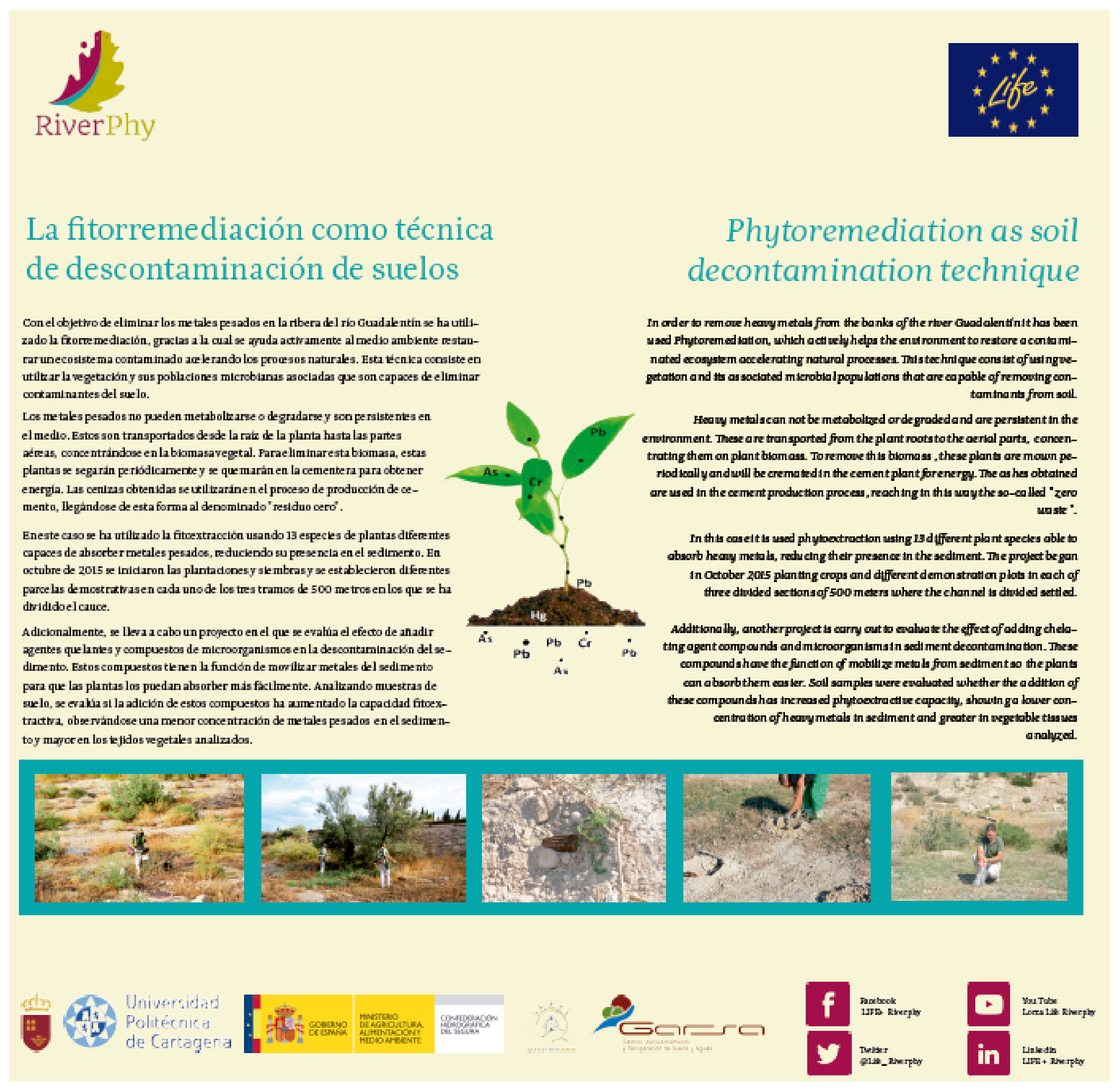
- Beltrá Castillo, J.C.; García Orenes, F.; Mora Navarro, J.; Murcia Navarro, F.J.; Zornoza Belmonte, R.; Faz Cano, Á.; Gómez-Garrido, M. Rehabilitation of River Sediments Contaminated by Heavy Metals from Tanning Industries Using the Phytoextraction Technique. In Proceedings of the 19th EGU General Assembly, EGU2017, Vienna, Austria, 23–28 April 2017; p. 4025. [Google Scholar]
- Gonzalez-Fernandez, O.; Queralt, I.; Manteca, J.I.; Garcia, G.; Carvalho, M.L. Distribution of Metals in Soils and Plants around Mineralized Zones at Cartagena-La Unión Mining District (SE, Spain). Environ. Earth Sci. 2011, 63, 1227–1237. [Google Scholar] [CrossRef]


| Parameter | Tolerance Values | ||
|---|---|---|---|
| Soil Type | Acid soils | Basic or alkaline soils Limestone soils (pH 7.3–8.5)
| Edaphic indifference |
| Weather | Moderately rainy (500–2000 mm) | Arid (250–500 mm) | Desert (<200 mm) |
| Salinity | Sensitive <1 dS m−1 | Moderately tolerant 1–3 dS m−1 | Tolerant >3 dS m−1 |
| Phytostabilization | Yes | No | |
| Element | Case Study 1 | Case Study 2 | Soil Salinity and Metal Toxicity Limit * |
|---|---|---|---|
| pH | 2.87 | 7.8 | |
| EC (dS m−1) | 2.3 | 2.5 | 2.0 |
| OC (g kg−1) | 1.78 | 0.9 | |
| Nt (g kg−1) | 0.21 | 0.13 | |
| Cr (mg kg−1) | - | 790 | 66 |
| Cu (mg kg−1) | 91 | 43 | 200 |
| Zn (mg kg−1) | 1587 | 63 | 400 |
| Pb (mg kg−1) | 1762 | - | 100–500 |
| Cd (microg kg−1) | 21 | - | 3 |
| As (mg kg−1) | 384 |
Publisher’s Note: MDPI stays neutral with regard to jurisdictional claims in published maps and institutional affiliations. |
© 2022 by the authors. Licensee MDPI, Basel, Switzerland. This article is an open access article distributed under the terms and conditions of the Creative Commons Attribution (CC BY) license (https://creativecommons.org/licenses/by/4.0/).
Share and Cite
Parra, A.; Conesa, E.; Zornoza, R.; Faz, Á.; Gómez-López, M.D. Decision Pattern for Changing Polluted Areas into Recreational Places. Agronomy 2022, 12, 775. https://doi.org/10.3390/agronomy12040775
Parra A, Conesa E, Zornoza R, Faz Á, Gómez-López MD. Decision Pattern for Changing Polluted Areas into Recreational Places. Agronomy. 2022; 12(4):775. https://doi.org/10.3390/agronomy12040775
Chicago/Turabian StyleParra, Alfonso, Encarnación Conesa, Raúl Zornoza, Ángel Faz, and María Dolores Gómez-López. 2022. "Decision Pattern for Changing Polluted Areas into Recreational Places" Agronomy 12, no. 4: 775. https://doi.org/10.3390/agronomy12040775
APA StyleParra, A., Conesa, E., Zornoza, R., Faz, Á., & Gómez-López, M. D. (2022). Decision Pattern for Changing Polluted Areas into Recreational Places. Agronomy, 12(4), 775. https://doi.org/10.3390/agronomy12040775