Autonomous Wireless Sensor Networks in an IPM Spatial Decision Support System †

 ,
, 
Abstract
1. Introduciton
Impact on Integrated Pest Management
2. Materials and Methods
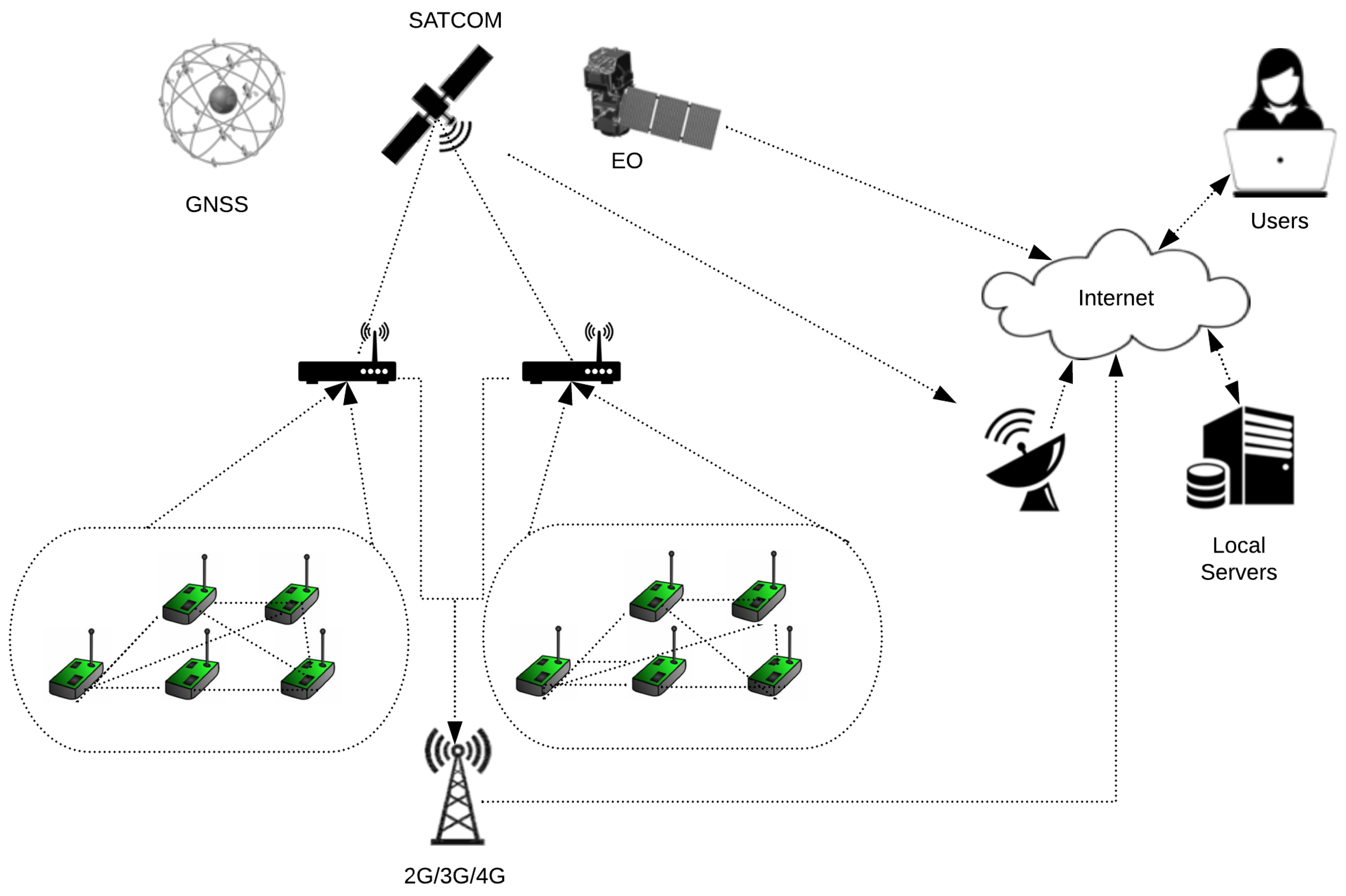
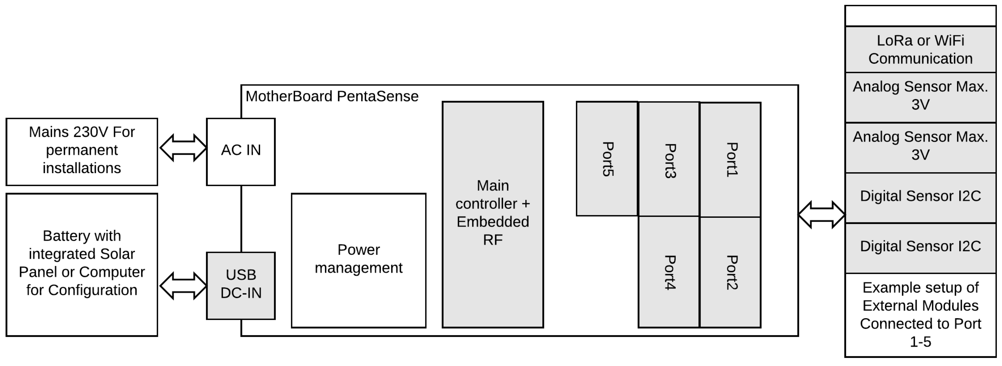
2.1. The PentaSense Network
2.2. Controler Board
2.3. Communication Module
2.3.1. RF Communication Module
2.3.2. Satellite Communication
2.3.3. LoRa Communicaiton Module
2.4. Embedded Energy Harvesting
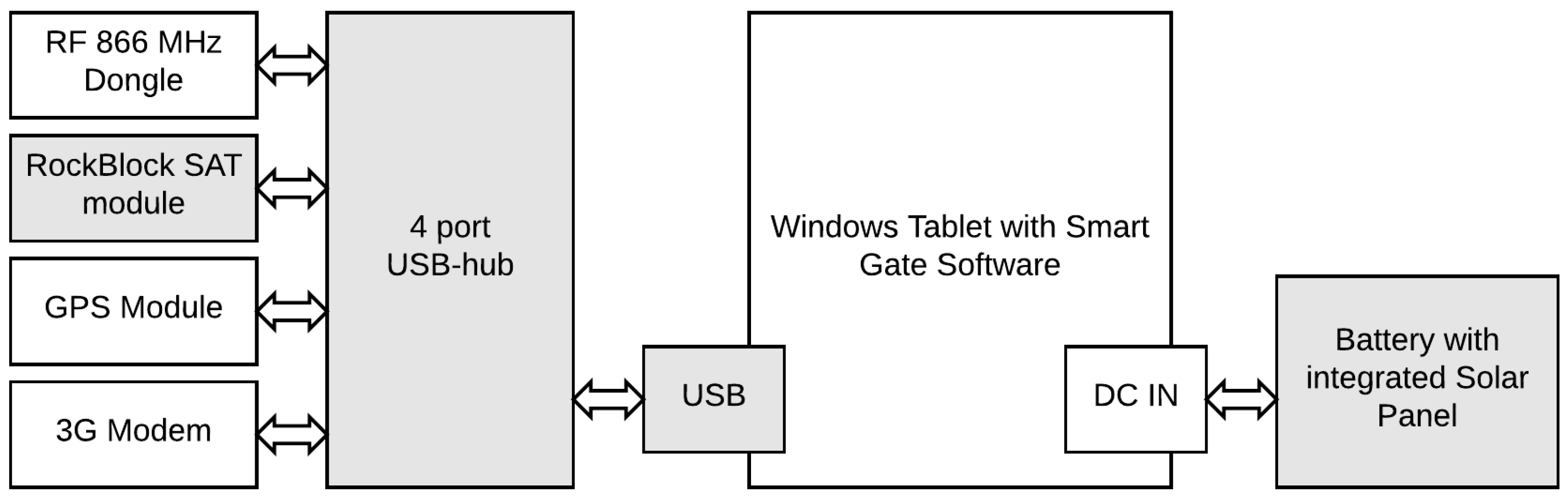
2.5. Gateway
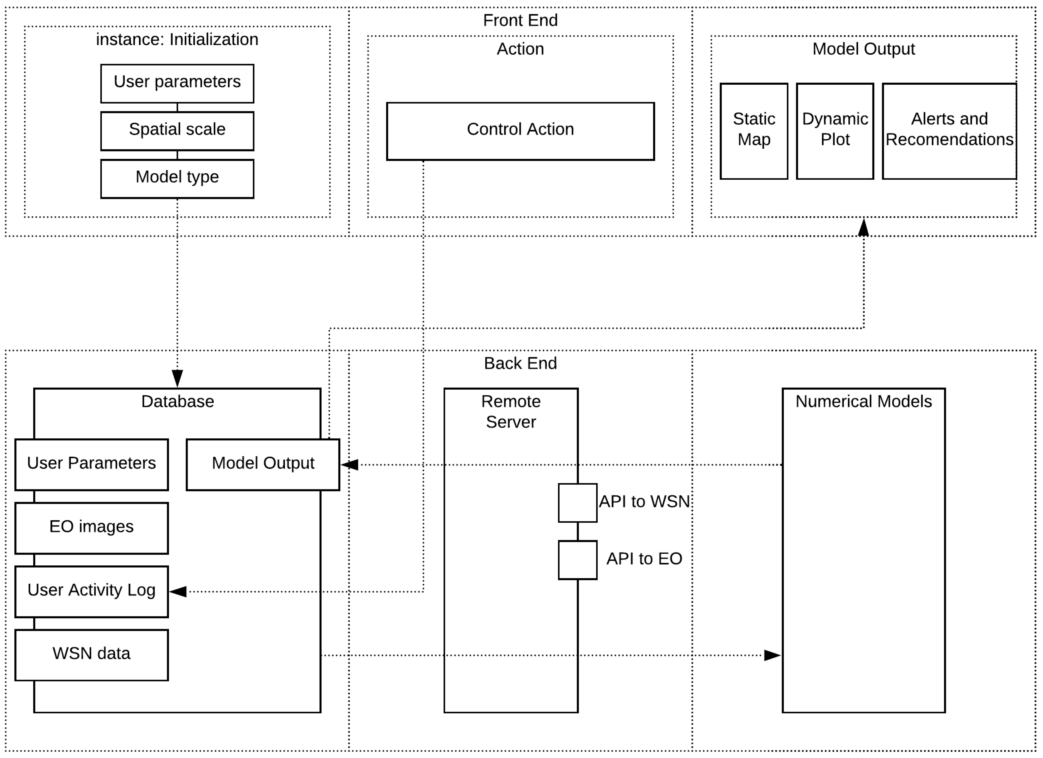
2.6. SDSS
Case Study: ASSESSING the Climatic Suitability for the Establishment of Aedes albopictus in Belgium
3. Results
3.1. Testing the WSN
3.1.1. Testing the SatCom Module
- (a)
- Signal strength: The signal strength is examined on a 0–5 level scale, 0 meaning no connection and 5 signifying maximum signal strength. Signal strength was 0 for cases where the module did not have a clear view of the sky. When placed outdoors, the test demonstrated signal attenuation as a function of cloud cover and precipitation. Signal strength varied between 1 and 5. A reliable connection (≥3) was reached when cloud cover was less than 5/10. Concerning precipitation, the extent of signal attenuation depends on the rate as well as on the raindrop size. The interference during the test was significant, reducing the signal to 0.
- (b)
- Data Loss: Since the RockBlock SBD module does not store information for tracking the number of lost data packages, for the purpose of this test we developed a set with sequenced, numbered and time-stamped data packets with the maximum payload (i.e., 340 bytes). The test was carried out on three segments of the communication chain: (i) The number of transmissions requested by the sink; (ii) number of transmissions billed by the RockBlock data-operator; and (iii) number of packets received at the sink. Two configuration bugs were discovered: a discrepancy in the number of sent and number of billed packets which can be attributed to the module itself, and another between the number of billed and the number of packets received at the sink which is related to the signal strength. Namely, when the signal strength is below 3 some packets that were billed were not received at the sink.
- (c)
- Bandwidth: The RockBlock 9603 SBD module operates with RF between 1616–1626.5 MHz. The bandwidth depends heavily on weather conditions such as cloud cover, precipitation and in a lesser manner temperature and relative humidity. The attenuation effect of rain depends on the ratio of the corresponding uplink wavelength and raindrop diameter. We were able to send up to 20 data-packets with full payload per minute without data loss under ideal signal conditions (level 5).
- (d)
- Course Grain Localization: The communication module provides very basic course grain localization without the need for an extra GPS module, reducing the overall cost of the system. The localization precision exhibited significant variation with the radius between 2 and 30 km depending on the strength of the SatCom signal.
3.1.2. Testing the WSN Nodes
- (a)
- Point to point communication: Firstly, the maximum distance between the sensor and sink was determined as the distance at which RSSI is 0 dBm (1 mW). Indoors this value was 50 m. Secondly, we consider data rates at different increments of the maximum distance (50 m), while keeping the data loss rates below 2%. The rate was 48 kbps up to approximately 50 m (maximum distance), 64 kbps up to approximately 40 m, 128 kbps up to approximately 30 m 256 kbps (maximum data rate) up to approximately 20 m.
- (b)
- Energetic autonomy: The test performed consists of communicating a ‘still alive signal’ at 0 dBm to the sink every 10 s. Full Energetic autonomy was achieved during the test (8 weeks) based on a 10,000 mAh solar chargeable power bank. The power bank was still 75% charged at the end of the test. The solar panels of the power bank where positioned behind a window in North-East direction.
- (c)
- Mesh network configuration: An extended indoor lab test which consists of 15 sensors has been performed. The sensors have been distributed in a three-story building, with 5 sensors on each floor. The size of the building is approximately 30 m by 120 m. Each floor has a height of 4 m. The distance between the sensors was typically 30 m, the data rate was set to 48 kbps. The test was performed successfully with this configuration.
- (d)
- Automated discovery: This test was performed to evaluate the speed and ability of the sink to discover new nodes as they are introduced. For a set of 15 newly introduced sensors, the discovery time was bellow 30 s.
- (e)
- Data loss: In this test, we take a look at the number of lost data-packets due to interference, packet collisions or other unknown influences. We found that the results depend chiefly on the number of allowed transmissions (Table 1). The system was observed for 24 h with the sensoring duty cycle set to 1 sample per minute with packet size of 24 bytes. The proprietary routing protocol was based on time-division multiplexing over the network mesh.
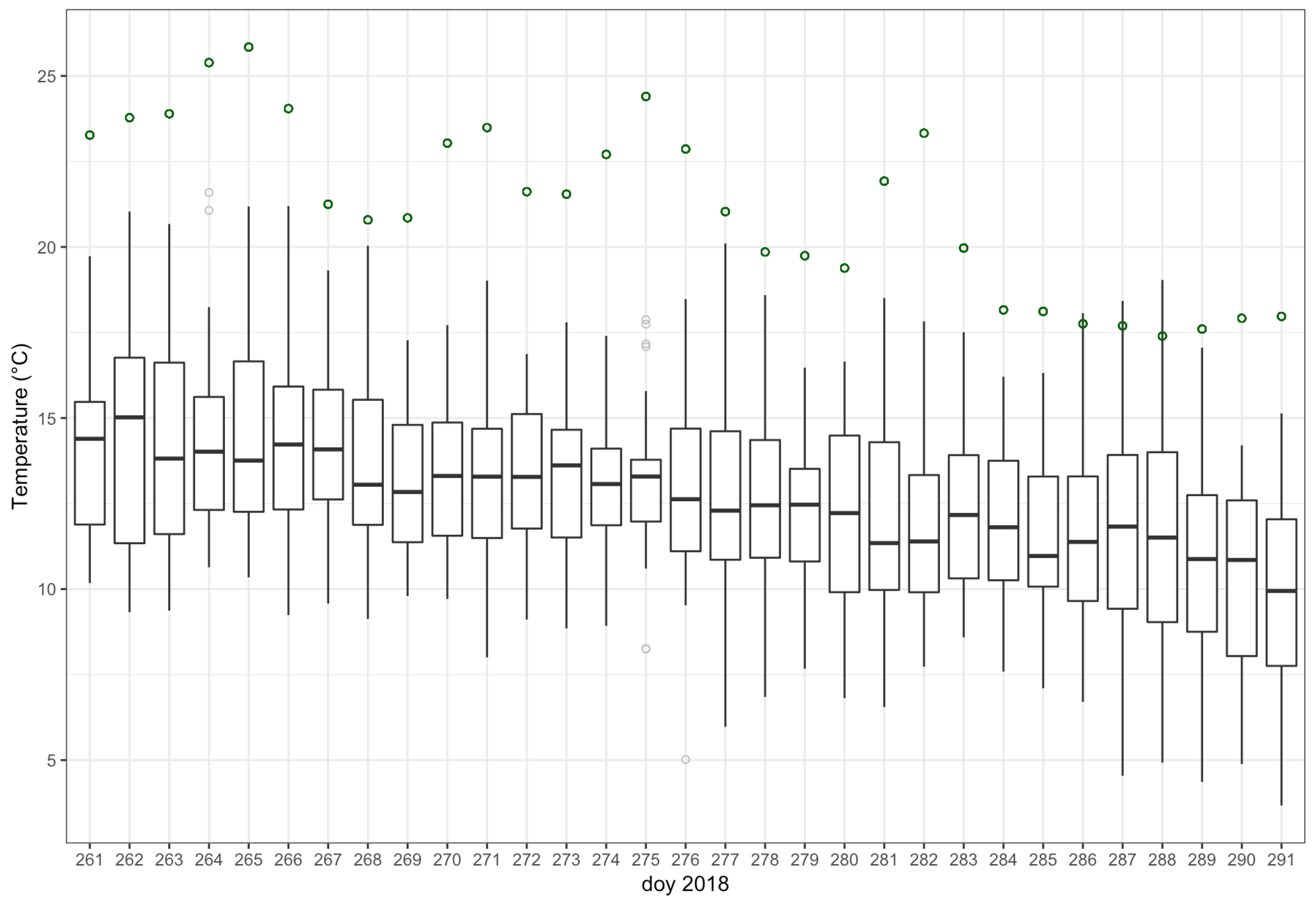
3.2. Case Study: Aedes albopictus in Belgium
4. Discussion
Author Contributions
Funding
Conflicts of Interest
Abbreviations
| API | Application Programming Interface |
| CRC | Cycle Redundancy Check |
| EO | Earth Observations |
| IPM | Integrated Pest Management |
| MCDA | Multi Criteria Decision Analysis |
| NRT | Near Real Time |
| NRZ | Non Return To Zero |
| PCB | Printed Circuit Board |
| RF | Radio Frequency |
| SBD | Short Burst Data |
| SMT | Surface Mount Technology |
| SPI | Serial Peripheral Inerface |
| USART | Universal Synchronous/Asynchronous Receiver/Transmitter |
| WAN | Wide Area Network |
| WSN | Wireless Sensor Network |
References
- World Health Organisation. Vector Borne Disease. Available online: https://www.who.int/news-room/fact-sheets/detail/vector-borne-diseases (accessed on 14 April 2019).
- Gartner. Newsroom: Press Release. Available online: https://www.gartner.com/technology/pressRoom.do?id=3598917 (accessed on 14 April 2019).
- Das, S.; Maitra, A.; Shukla, A.K. Rain attenuation modeling in the 10–100 GHz frequency using drop size distributions for different climatic zones in tropical India. Prog. Electromagn. Res. 2010, 25, 211–224. [Google Scholar] [CrossRef]
- Sharma, A.; Jain, P. Effects of rain on radio propagation in GSM. Int. J. Adv. Eng. Appl. 2010, 2010, 83–86. [Google Scholar]
- MODIS. NASA, Moderate Resolution Imaging Spectroradiometer. Available online: https://modis.gsfc.nasa.gov/data/ (accessed on 14 April 2019).
- Sentinel Mission. ESA, Sentinel-2 Data Products. Available online: https://sentinel.esa.int/web/sentinel/missions/sentinel-2/data-products (accessed on 14 April 2019).
- Rochlin, I.; Ninivaggi, D.V.; Hutchinson, M.L.; Farajollahi, A. Climate change and range expansion of the Asian tiger mosquito (Aedes albopictus) in Northeastern USA: Implications for public health practitioners. PLoS ONE 2013, 8, e60874. [Google Scholar] [CrossRef] [PubMed]
- De Roeck, E.; Van Coillie, F.; De Wulf, R.; Soenen, K.; Charlier, J.; Vercruysse, J.; Hantson, W.; Ducheyne, E.; Hendrickx, G. Fine-scale mapping of vector habitats using very high resolution satellite imagery: A liver fluke case-study. Geospat. Health 2014, 8, S671–S683. [Google Scholar] [CrossRef] [PubMed]
- Mairota, P.; Cafarelli, B.; Labadessa, R.; Lovergine, F.; Tarantino, C.; Lucas, R.M.; Nagendra, H.; Didham, R.K. Very high resolution Earth observation features for monitoring plant and animal community structure across multiple spatial scales in protected areas. Int. J. Appl. Earth Obs. Geoinf. 2015, 37, 100–105. [Google Scholar] [CrossRef]
- Datir, S.; Wagh, S. Monitoring and detection of agriculture disease using WSN. IJCA 2014, 87, 09758887. [Google Scholar] [CrossRef]
- Srivastav, N.; Chopra, G.; Jain, P.; Khatter, B. Pest Monitor and control system using WSN with special referance to Acoustic Device. J. Entomol. Zool. Stud. 2013, 3, 92–99. [Google Scholar]
- Srinivas, S.; Harsha, K.; Sujatha, A.; Kumar, N.G. Eff cient Protection of Palms from RPW Larvae using Wireless Sensor Networks. Int. J. Comput. Sci. Issues 2013, 10, 192–200. [Google Scholar]
- Al-Manie, M.A.; Alkanhal, M.I. Acoustic detection of the red date palm weevil. Int. J. Signal Process. 2004, 1, 1–12. [Google Scholar]
- Azfar, S.; Nadeem, A.; Basit, A. Pest detection and control techniques using wireless sensor network: A review. J. Entomol. Zool. Stud. 2015, 3, 92–99. [Google Scholar]
- Bajwa, W.I.; Coop, L.; Kogan, M. Integrated pest management (IPM) and Internet-based information delivery systems. Neotropical Entomol. 2003, 32, 373–383. [Google Scholar] [CrossRef]
- University of Caifornia, Acriculture and Natural Resources. DD Models: Insects, Mites, Diseases, Plants, and Beneficials. Available online: http://ipm.ucanr.edu/MODELS/index.html (accessed on 20 May 2019).
- Uspect—Agricultural, Pest Management, and Plant Biosecurity Decision Support in the US. IPM Pest and Plant Disease Models and Forecasting. Available online: http://pnwpest.org/wea (accessed on 20 May 2019).
- Southwest Technical Resource Center for School IPM. IPM Cost Calculator. Available online: http://www.ipmcalculator.com/ (accessed on 20 May 2019).
- University of Caifornia, Acriculture and Natural Resources. California PestCast: Disease Model Database. Available online: http://ipm.ucanr.edu/DISEASE/DATABASE/diseasemodeldatabase.html (accessed on 20 May 2019).
- Damos, P. Modular structure of web-based decision support systems for integrated pest management. A review. Agron. Sustain. Dev. 2015, 35, 1347–1372. [Google Scholar] [CrossRef]
- Brown, J.H. On the relationship between abundance and distribution of species. Am. Nat. 1984, 124, 255–279. [Google Scholar] [CrossRef]
- Rousse, P.; Gourdon, F.; Roubaud, M.; Chiroleu, F.; Quilici, S. Biotic and abiotic factors affecting the flight activity of Fopius arisanus, an egg-pupal parasitoid of fruit fly pests. Environ. Entomol. 2009, 38, 896–903. [Google Scholar] [CrossRef] [PubMed]
- Patz, J.; Githeko, A.; McCarty, J.; Hussein, S.; Confalonieri, U.; De Wet, N. Climate change and infectious diseases. Clim. Chang. Hum. Health Risks Responses 2003, 2, 103–132. [Google Scholar]
- Poveda, G.; Graham, N.E.; Epstein, P.R.; Rojas, W.; Quiñones, M.L.; Velez, I.D.; Martens, W.J. Climate and ENSO variability associated with vector-borne diseases in Colombia. El Niño South. Oscill. Multiscale Var. Glob. Reg. Impacts 2000, 1, 183–204. [Google Scholar]
- Harvell, C.; Kim, K.; Burkholder, J.; Colwell, R.; Epstein, P.R.; Grimes, D.; Hofmann, E.; Lipp, E.; Osterhaus, A.; Overstreet, R.M.; et al. Emerging marine diseases–climate links and anthropogenic factors. Science 1999, 285, 1505–1510. [Google Scholar] [CrossRef]
- Hales, S.; Weinstein, P.; Souares, Y.; Woodward, A. El Niño and the dynamics of vectorborne disease transmission. Environ. Health Perspect. 1999, 107, 99–102. [Google Scholar]
- Abiodun, G.J.; Maharaj, R.; Witbooi, P.; Okosun, K.O. Modelling the influence of temperature and rainfall on the population dynamics of Anopheles arabiensis. Malar. J. 2016, 15, 364. [Google Scholar] [CrossRef]
- Ahumada, J.A.; Laoointe, D.; Samuel, M.D. Modeling the population dynamics of Culex quinquefasciatus (Diptera: Culicidae), along an elevational gradient in Hawaii. J. Med. Entomol. 2004, 41, 1157–1170. [Google Scholar] [CrossRef]
- Paaijmans, K.P.; Imbahale, S.S.; Thomas, M.B.; Takken, W. Relevant microclimate for determining the development rate of malaria mosquitoes and possible implications of climate change. Malar. J. 2010, 9, 196. [Google Scholar] [CrossRef] [PubMed]
- IUCNGISD. Global Invasive Species Database. Available online: http://www.iucngisd.org/gisd/ (accessed on 14 April 2019).
- Paupy, C.; Delatte, H.; Bagny, L.; Corbel, V.; Fontenille, D. Aedes albopictus, an arbovirus vector: From the darkness to the light. Microbes Infect. 2009, 11, 1177–1185. [Google Scholar] [CrossRef] [PubMed]
- Benedict, M.Q.; Levine, R.S.; Hawley, W.A.; Lounibos, L.P. Spread of the tiger: global risk of invasion by the mosquito Aedes albopictus. Vector-Borne Zoonotic Dis. 2007, 7, 76–85. [Google Scholar] [CrossRef] [PubMed]
- Waldock, J.; Chandra, N.L.; Lelieveld, J.; Proestos, Y.; Michael, E.; Christophides, G.; Parham, P.E. The role of environmental variables on Aedes albopictus biology and chikungunya epidemiology. Pathog. Glob. Health 2013, 107, 224–241. [Google Scholar] [CrossRef] [PubMed]
- Iridium. RockBLOCK Mk2. Available online: https://www.iridium.com/products/rock-seven-rockblock-mk2/ (accessed on 14 April 2019).
- CloudBerry Lab. Free Remote Assistance Software for Windows. Available online: https://www.cloudberrylab.com/remote-assistant.aspx (accessed on 14 April 2019).
- TeamViewer. Remote Support, Remote Access, Service Desk, Online Collaboration and Meetings. Available online: https://www.teamviewer.com/en/ (accessed on 14 April 2019).
- WorldClim. Global Climate Data—Free Climate Data for Ecological Modeling and GIS. Available online: http://www.worldclim.org/node/1 (accessed on 14 April 2019).
- R Development Core Team. R: A Language and Environment for Statistical Computing; R Foundation for Statistical Computing: Vienna, Austria, 2008; ISBN 3-900051-07-0. [Google Scholar]
- Petrić, M.; Lalić, B.; Ducheyne, E.; Djurdjević, V.; Petrić, D. Modelling the regional impact of climate change on the suitability of the establishment of the Asian tiger mosquito (Aedes albopictus) in Serbia. Clim. Chang. 2017, 142, 361–374. [Google Scholar] [CrossRef]
- Petrić, M.; Lalić, B.; Pajović, I.; Micev, S.; Đurđević, V.; Petrić, D. Expected Changes of Montenegrin Climate, Impact on the Establishment and Spread of the Asian Tiger Mosquito (Aedes albopictus), and Validation of the Model and Model-Based Field Sampling. Atmosphere 2018, 9, 453. [Google Scholar] [CrossRef]
- NOAA. Version 4 DMSP-OLS Nighttime Lights Time Series. Available online: http://ngdc.noaa.gov/eog/dmsp/downloadV4composites.html (accessed on 14 April 2019).
- Pcfruit. Het Proefcentrum Fruitteelt. Available online: https://www.pcfruit.be/nl (accessed on 14 April 2019).
- Petrić, M. Modelling the Influence of Meteorological Conditions on Mosquito Vector Population Dynamics (Diptera, Culicidae). Ph.D. Thesis, University of Gent and University of Novi Sad, Novi Sad, Serbia. Unpublished.
- ECMWF. Copernicus Climate Change Service (C3S) (2017): ERA5: Fifth Generation of ECMWF Atmospheric Reanalyses of the Global Climate. Copernicus Climate Change Service Climate Data Store (CDS). Available online: https://cds.climate.copernicus.eu/cdsapp#!/home (accessed on 14 April 2019).
- European Centre for Disease Precention and Control. Technical Report 2009: Development of Aedes albopictus Risk Maps. Available online: https://ecdc.europa.eu/sites/portal/files/media/en/publications/Publications/0905_TER_Development_of_Aedes_Albopictus_Risk_Maps.pdf (accessed on 14 April 2019).
- Fischer, D.; Thomas, S.M.; Niemitz, F.; Reineking, B.; Beierkuhnlein, C. Projection of climatic suitability for Aedes albopictus Skuse (Culicidae) in Europe under climate change conditions. Glob. Planet. Chang. 2011, 78, 54–64. [Google Scholar] [CrossRef]
- Caminade, C.; Medlock, J.M.; Ducheyne, E.; McIntyre, K.M.; Leach, S.; Baylis, M.; Morse, A.P. Suitability of European climate for the Asian tiger mosquito Aedes albopictus: recent trends and future scenarios. J. R. Soc. Interface 2012, 9, 2708–2717. [Google Scholar] [CrossRef]
- Institute of Tropical Medicine, Antwerp. New Sightings of Tiger Mosquitoes in Belgium. Available online: https://www.itg.be/E/Article/new-sightings-of-tiger-mosquito-in-belgium (accessed on 14 April 2019).
- Deblauwe, I.; Demeulemeester, J.; De Witte, J.; Hendy, A.; Sohier, C.; Madder, M. Increased detection of Aedes albopictus in Belgium: no overwintering yet, but an intervention strategy is still lacking. Parasitol. Res. 2015, 114, 3469–3477. [Google Scholar] [CrossRef][Green Version]
- Medlock, J.M.; Avenell, D.; Barrass, I.; Leach, S. Analysis of the potential for survival and seasonal activity of Aedes albopictus (Diptera: Culicidae) in the United Kingdom. J. Vector Ecol. 2006, 31, 292–305. [Google Scholar] [CrossRef]
- Meehl, G.A.; Zwiers, F.; Evans, J.; Knutson, T.; Mearns, L.; Whetton, P. Trends in extreme weather and climate events: Issues related to modeling extremes in projections of future climate change. Bull. Am. Meteorol. Soc. 2000, 81, 427–436. [Google Scholar] [CrossRef]
- Kunkel, K.E.; Pielke, R.A., Jr.; Changnon, S.A. Temporal fluctuations in weather and climate extremes that cause economic and human health impacts: A review. Bull. Am. Meteorol. Soc. 1999, 80, 1077–1098. [Google Scholar] [CrossRef]


| Test Name | Test Parameters | Measured | Target |
|---|---|---|---|
| Signal Strength | RockBlock signal strength; cloud cover 10/10; raining | 1 | ≥3 |
| RockBlock signal strength; cloud cover 10/10; no rain | 2 | ≥3 | |
| RockBlock signal strength; cloud cover 5/10; no rain | 3 | ≥3 | |
| RockBlock signal strength; cloud cover 3/10; no rain | 4 | ≥3 | |
| RockBlock signal strength; cloud cover 0/10; no rain | 5 | ≥3 | |
| Data Loss | Number of transmissions | 100 | 100 |
| Number of packets billed | 100 | 100 | |
| Number of packets received | 96 | 90 | |
| Bandwidth | No of packets with full pay-load (340 bytes)/min | 20 | >6 |
| Coarse Grain Localization | Localization error; RockBlock signal strength 5 | <2 km | - |
| Localization error; RockBlock signal strength 4 | <5 km | - | |
| Localization error; RockBlock signal strength 3 | <15 km | - | |
| Localization error; RockBlock signal strength 2 | <30 km | - | |
| Localization error; RockBlock signal strength 1 | >30 km | - | |
| Point to point communication | Maximum data rate; 50 m distance | 48 kbps | Max data loss <2% |
| Maximum data rate; 40 m distance | 64 kbps | Max data loss <2% | |
| Maximum data rate; 30 m distance | 128 kbps | Max data loss <2% | |
| Maximum data rate; 20 m distance | 256 kbps | Max data loss <2% | |
| Energy autonomy | Still alive signal at 0 dBm to sink every 10 s | 75% charged at end of test | Min 8 weeks |
| Mesh network configuration | 15 sensor, 30 m, 48 kbps | 15 | 15 |
| Automated discovery | Automatic discovery of 15 sensors by the gateway | <30 s | <1 min |
| Data loss test | 24 h; number of allowed retransmissions 0 | <3% | <1% |
| 24 h; number of allowed retransmissions 1 | <1% | <1% | |
| 24 h; number of allowed retransmissions 2 | <0.2% | <1% | |
| 24 h; number of allowed retransmissions 3 | <0.2% | <1% | |
| 24 h; number of allowed retransmissions 4 | <0.2% | <1% |
© 2019 by the authors. Licensee MDPI, Basel, Switzerland. This article is an open access article distributed under the terms and conditions of the Creative Commons Attribution (CC BY) license (http://creativecommons.org/licenses/by/4.0/).
Share and Cite
Petrić, M.; Vandendriessche, J.; Marsboom, C.; Matheussen, T.; Ducheyne, E.; Touhafi, A. Autonomous Wireless Sensor Networks in an IPM Spatial Decision Support System. Computers 2019, 8, 43. https://doi.org/10.3390/computers8020043
Petrić M, Vandendriessche J, Marsboom C, Matheussen T, Ducheyne E, Touhafi A. Autonomous Wireless Sensor Networks in an IPM Spatial Decision Support System. Computers. 2019; 8(2):43. https://doi.org/10.3390/computers8020043
Chicago/Turabian StylePetrić, Mina, Jurgen Vandendriessche, Cedric Marsboom, Tom Matheussen, Els Ducheyne, and Abdellah Touhafi. 2019. "Autonomous Wireless Sensor Networks in an IPM Spatial Decision Support System" Computers 8, no. 2: 43. https://doi.org/10.3390/computers8020043
APA StylePetrić, M., Vandendriessche, J., Marsboom, C., Matheussen, T., Ducheyne, E., & Touhafi, A. (2019). Autonomous Wireless Sensor Networks in an IPM Spatial Decision Support System. Computers, 8(2), 43. https://doi.org/10.3390/computers8020043