Abstract
The tourism sector, a major economic contributor, seeks innovative approaches to enhance the user experience. In this evolving landscape of global tourism, using augmented reality (AR) technology can be a way to increase the engagement of tourists, but current AR applications often overwhelm (and bore) the users with excessive information. This study addresses the challenge of designing an AR solution that increases the efficiency of exploring and navigating tourist routes, while minimizing information overload by only offering contextualized information about those itineraries. The AR application delivers personalized details about historical monuments, points of interest (POIs), and cultural landmarks, enriching educational experiences and promoting local tourism. The solution was tested on two historic routes, one in Porto and the other in Chaves (both in Portugal), chosen for their cultural richness. The study’s conclusions, derived from experimentation and statistical analysis, confirm the AR technology’s effectiveness in enhancing the efficiency, immersion, and contextualization of tourist routes.
1. Introduction
Tourist routes, intentionally designed to attract visitors, play a significant role in promoting locations, generating revenue, and preserving cultural and environmental patrimony. In contemporary tourism, the demand for unique and personalized experiences has become crucial for tourists. Venturing into unexplored places, delving into particular details of the local history, and discovering hidden treasures are key motivations driving tourists’ curiosity. However, tourists often face challenges in finding specific and detailed information about attractions and points of interest (POIs) along their routes. This gap becomes evident when tourists have specific interests, such as exploring medieval areas or visiting monuments linked to specific historical events, leading to less satisfactory experiences due to the lack of contextual information. As such, despite their importance, traditional tour guides still fail to provide customized experiences tailored to individual preferences [1].
From the understanding of the gap in the availability of detailed and contextualized information in the exploration of tourist itineraries, the proposal was that the implementation of AR technology in these itineraries could fill the identified needs. Therefore, this study aimed to integrate augmented reality (AR) to enhance the touristic experience by offering more efficient, personalized, and enriching route explorations. The proposed solution aimed to reduce the time spent searching for information while providing relevant, contextual details without overwhelming tourists. Additionally, it sought to promote local tourism by ensuring a deeper engagement with destinations, enhance the educational aspect of tourism through historical and cultural insights, improve the personalization and contextualization of tourist exploration, and demonstrate flexibility across diverse tourist routes. The research hypothesis was then that by implementing augmented reality technology on tourist routes, the exploration of these routes would become more efficient, immersive, and contextualized.
Design science research (DSR) was selected as the research methodology for this study as it aligns with the nature of developing and evaluating innovative technological solutions, particularly in the context of using augmented reality (AR) for enhancing tourism experiences. DSR emphasizes the creation and refinement of artifacts, including software applications, frameworks, and models, that address practical problems. Given that this research involved designing an AR-based solution to improve tourist route navigation and engagement, DSR provided a structured approach to iteratively develop, test, and refine the application based on empirical findings. This methodology ensured that the research moved beyond theoretical exploration and delivered a tangible, validated solution that could have direct applicability in the tourism sector.
Moreover, DSR is particularly well-suited for research that integrates technology and user-centered design. In this study, the AR application was tested with real users in different locations, allowing for iterative refinements based on usability and impact assessments. This aligns with DSR’s cyclical process of problem identification, artifact development, evaluation, and refinement, ensuring that the final solution is both functional and effective. By applying DSR, the research bridged the gap between theoretical innovation and practical application, demonstrating the real-world value of AR in tourism while contributing to the broader knowledge base on the intersection of immersive technologies and user experience design.
2. State of the Art
The tourism sector plays a crucial role in the global economy, representing around 7.6% of the global gross domestic product (GDP) [2]. Currently, it is one of the primary drivers of economic growth worldwide, taking people from all over the world to a variety of destinations, increasing the local economy and culture, disseminating the historical and natural heritage, and promoting diversity. In this context it is crucial that the tourism industry continues to evolve and adapt to changes in tourist preferences.
During the pandemic, tourism was one of the economic sectors that suffered the most negative impact. After the pandemic, there was a need to adapt to the new times and to provide tourists with innovative and engaging experiences while driving innovation in business models and taking advantage of new immersive technologies [3]. Millennials (a Millennial is a person born between the early 1980s and the late 1990s) and Generation Z (Generation Z the generation of people born in the late 1990s and early 2000s) also significantly contributed to this paradigm shift as they are passionate about innovative technology, particularly smartphones, and use it in their daily lives. According to a TripAdvisor Study, “42% of travelers around the world are Connected Travelers that have used a smartphone to plan or book a trip” [4]. Table 1 shows some conclusions from that study.

Table 1.
How mobile technology is being used for vacations [4].
With the increasing tendency to travel, it makes sense that tourism technology trends would be driven by the preferences and behaviors of these generations. And the technological advance in this sector can even increase the impact of the touristic experience, by saving time and money, automating processes, and improving travel efficiency [5]. And augmented reality (AR) technology seems to be a way to foster this process.
2.1. Augmented Reality (AR)
Since the creation of Sketchpad in 1963 by Ivan Sutherland, the field of augmented reality has progressed in multiple directions. AR today can be described as an interactive and immersive technology that uses multiple techniques and mixes the real world with digital components like audio, images, objects, text, and video. It utilizes tracking systems to place virtual objects in the real world and then presents these components to the user. Syed et al. surveyed the literature and proposed a general overview of the AR panorama, including application areas, development tools, and tracking technologies [6]. To obtain a deeper understanding of AR, it is essential to be familiar with the fundamental concepts and terminology frequently used in this technology [7]:
- Reality View: refers to the real-time video stream from a smartphone camera that an AR application enhances by adding virtual objects, providing an augmented experience for the user.
- Registration and Tracking: describes the techniques available for aligning a virtual object with a three-dimensional point in the view of reality.
- POI: refers to a data point often linked to a specific physical location (longitude, latitude, altitude) or a visual pattern (marker, book cover, etc.) that the AR application can display.
- Virtual Object: a type of digital media that the AR application renders and overlays on the real-world scene. Typical content consists of text, icons, 2D photos, and 3D models.
- Channels, Layers, and Worlds: references to published collections of connected POIs and linked virtual objects.
In terms of architecture, according to Li and Shang, AR apps involve several steps, such as capturing and tracking the real world, building a virtual world, rendering, analyzing the scene, and interacting with virtual objects to create immersive experiences [8].
2.1.1. Augmented Reality Technology
AR technology can be achieved through wearable and non-wearable devices. Wearable devices include headsets and helmets, and non-wearable devices include mobile devices and stationary devices like TVs and PCs, among others [9]. While display technologies provide virtual content to the viewer’s eyes, tracking systems follow a real-world pattern.
Marker-based AR is a technology where the AR content is placed on objects in the real world, which can be either paper-based or physical objects, that serve as markers or triggers. The marker, which needs to be unique, is recognized by the AR system when the user scans it with their mobile device [10]. As a result of the mobile scan, and based on the marker’s position, the additional content that was previously created will then be displayed on top of the marker. In essence, these marks act as a link between the real world and the digital one. Differing from marker-based, marker-less AR does not depend on specific markers to determine where a virtual object should appear. “Marker-less AR functionality allows developers to create digital applications that overlay interactive augmentations on physical surfaces, without the need for a marker”. The most used types of this type of AR are as follows:
- Location-Based AR: uses technologies like global positioning system (GPS), accelerometers, digital compasses, and other sensor systems to accurately determine the phone’s location and orientation. These sensors are available on smartphones, which means that AR is very accessible for the users. These applications rely on real-time positioning systems (RTLS), thereby obtaining information from sensors about the user’s current location and movements. By connecting the gathered data with points of interest (POI), the technology also establishes the specific position and method in which virtual data is integrated into the physical environment.
- Projection-Based AR: is often used to generate illusions about the depth, location, and orientation of an object. This technology provides digital information in a static environment, and the main goal is to render virtual things on or within a user’s real physical space, where light is projected into a surface. The interaction occurs by physically touching the projected surface [11].
- Superimposition-Based AR: also known as Spatial AR, is a technology where virtual objects or information are overlapped on the physical world. In order to create a hybrid experience that improves the user’s view of reality, computer-generated content is required to be integrated into the user’s view of the physical world [12].
Marker-based and marker-less AR are the two primary AR technologies, each suitable for different contexts. Marker-based systems are straightforward to use as they involve placing markers in real locations, which a camera can detect. Users simply point their devices at these markers to view digital content, making this approach ideal for promoting products or services through mechanisms like QR codes. In contrast, marker-less AR represents a more advanced form of AR. It uses computer vision to recognize real-world objects and display relevant information about them without requiring special markers. This technology is considered a more current technology as it allows for a more intuitive user experience, with objects detected by a camera and computer vision system seamlessly integrating digital content into the real world.
2.1.2. Augmented Reality in Tourism
AR has significantly contributed to the growth of the tourism industry, especially during the COVID-19 pandemic when physical interactions were limited. Most AR applications in tourism use marker-based and location-based technologies to enhance the tourist experience by providing relevant information and entertainment.
Typically, in this sector, most of the AR uses relate to travel guides, helping tourists to explore destinations, navigate cities, and identify POIs [13]. Therefore, it is normally accessed via mobile or wearable devices, making it affordable. Most AR triggers in tourism are location-based (37.3%), followed by marker-less (22%) and marker-based (11.9%) triggers [14].
AR in tourism can also be used as a marketing tool, enabling destinations to stand out in a competitive market by influencing tourists’ decisions to visit specific locations. AR applications offer novel ways to present information about tourist attractions, thereby enhancing the overall visitor experience [15]. For instance, AR can provide historical context, cultural information, and interactive elements, which help tourists engage more deeply with the touristic site even before they arrive [16] or when they are there [17].
AR is also increasingly used in mobile applications that enhance the on-site experience by allowing tourists to overlay old photographs to the site [3] or visualize historical reconstructions or future developments of sites, providing a more comprehensive understanding of the locations they visit. This innovation has proven to enhance tourist satisfaction and engagement by making their experience more informative and entertaining [18].
In cultural heritage tourism, AR plays a role in preserving sites while simultaneously providing rich, interactive experiences for visitors. It helps to reduce the physical strain on heritage sites by offering virtual representations that tourists can interact with, thus mitigating the wear and tear caused by over-tourism [19].
However, despite its potential, the adoption of AR in tourism is not without challenges. Issues such as the technological readiness of users, the need for robust and user-friendly applications, and the cultural differences in AR acceptance require careful consideration to maximize the effectiveness of AR in tourism [20].
In short, the key advantages of using AR in tourism are as follows:
- Better Navigation: It improves navigation by overlaying directions on the real-world view.
- Contextualized Information: It provides relevant information about attractions during exploration.
- Promotion and Marketing: It creates engaging marketing strategies that attract potential tourists.
- Customer Engagement: Positive experiences with AR apps lead to word-of-mouth promotion and social media sharing.
- Popularizing Destinations: Interactive AR presentations make tourist spots more appealing.
- Reviving Experiences: It adds excitement to revisits of museums and historic sites.
And the disadvantages and concerns of using this technology are [21]:
- Privacy Issues: Continuous recording by AR devices and collection of user data raise privacy concerns, requiring strict adherence to data usage laws like GDPR of the European Union.
- Real vs. Virtual Boundaries: The blending of real and digital worlds can cause safety issues.
- Technical Requirements: Implementing AR is expensive and requires advanced technology, challenging smaller organizations.
- Information Overload: With the small display of the smartphone, sometimes the user can feel overloaded with the AR information.
2.1.3. Use Cases of Augmented Reality in Tourism
The most common uses of AR in tourism relate to navigation, tour guides, cultural attractions, and educational tourism.
Augmented reality has revolutionized navigation, making it more accessible and personalized. By using GPS, cameras, and sensors, AR navigation apps help tourists easily locate and navigate through various locations, such as buildings, museums, and special locations. Google Maps Live View (Figure 1a,b) is a notable example, overlaying directions and landmarks on the user’s view, making navigation intuitive and engaging [22].
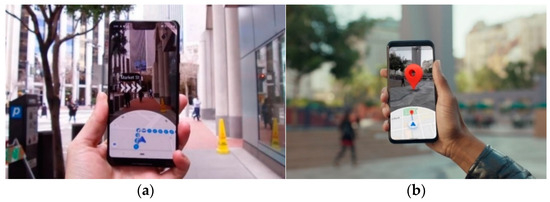
Figure 1.
(a) AR directions in Live View. (b) AR destination in Live View.
Research on the use of AR for navigation in tourism is presented in an article [23], which focuses on the initiative to develop a navigation app to promote tourism at the local historical attraction “Lawang Sewu”. Positive results from user acceptance testing indicated that 66.6% of participants enjoyed the application during the exploration of the state attraction, suggesting that the use of the application enhanced the user experience when interacting with Lawang Sewu and, consequently, improving the local tourism.
AR tour guides provide real-time information about POIs as tourists explore new destinations. The primary function of an AR tour guide is to offer real-time information about POI as travelers navigate through city streets. By utilizing their mobile devices, tourists can gain instant access to a wealth of knowledge about the historical significance, cultural context, and other relevant details of the places they encounter. This not only enriches their understanding of the destination but also adds layers of engagement to their overall travel experience [24].
Apps like Zumoko AR Tourist Guide enhance the experience by delivering informative content based on location services. These apps offer interactive POIs, travel planning, and navigation assistance, enriching the travel experience [25].
Research on the use of AR applications for tour guides in tourism is illustrated in the article [26], detailing an AR Tour Guide conducted at the iconic Gyeongbokgung, a cultural heritage site in Korea. The approach uses AR to virtually bring the past to life by overlaying animated 3D characters into historical sites. Additionally, contextual information such as tourist location and profiles are integrated to provide personalized guides. The prototype was successfully tested at Gyeongbokgung, highlighting the effectiveness of this innovative approach and its potential to enhance the tourist experience.
AR improves cultural attractions like museums, zoos, and oceanariums by providing immersive, interactive experiences. The Augmented Gallery, for instance, allows users to view paintings from London’s institutions in AR, enhancing public access to art during the pandemic [27]. Research on the use of AR in museums is presented in [28], which is focused on an AR prototype for information visualization based on a renowned Chinese artwork named “Along the River During the Qingming Festival”. With 58 evaluators participating, the results show that AR technology can trigger visitor engagement, facilitate learning, promote meaningful experiences, and establish emotional connections.
Educational tourism combines travel with learning experiences. AR enhances this by offering interactive educational content during trips. An innovative study in Western Macedonia, Greece, uses AR and VR to boost educational tourism, promoting local economic development by attracting more visitors to the region’s educational attractions [29]. Another study developed a solution that incorporates AR and VR to boost the touristic impact of areas of Western Macedonia, Greece. This Greek region faces socioeconomic challenges, including high unemployment rates, and could benefit significantly from increased tourism. The implementation of these innovative technologies not only enhanced the region’s educational attractions, but also attracted more tourists, promoting local economic development [30].
3. Solution Development
This chapter explores the technical development of the application, covering the solution design, implementation of key functionalities, and technology integration.
3.1. Tourist Routes
A well-designed tourist route must include several elements to provide an attractive and organized experience for tourists, such as the following:
- POI: highlighting the inclusion of significant tourist attractions, such as natural, cultural, historical, architectural, and recreational attractions.
- Information: Providing relevant information about the history, culture, and context of the places visited, enriching the tourist experience.
- Markers: efficient signs or markers along the route to guide the tourists along it.
- Logical Itinerary: logical organization of POIs to optimize tourists’ time and facilitate the path between attractions.
The proposed solution aimed to address the lack of contextualized and pertinent information along tourist routes, enhancing the overall experience with relevant and engaging content. It also includes the possibility of allowing the tourists to create their own routes and to capture the route info data (georeferenced visuals and text) that will be peer-validated and scored. This will create a large set of routes to be explored in many different locations.
For the validation of this solution, two historic routes were created in the Portuguese cities of Porto and Chaves.
3.1.1. Porto Route
The Porto Route is composed of the following POI:
- Lello Bookstore: considered one of the most beautiful bookstores in the world, with a captivating atmosphere for book and architecture enthusiasts.
- University of Porto: founded in 1911, the University of Porto is one of the best universities in Portugal, with distinctions from UNESCO.
- Clérigos Tower: the Baroque Torre dos Clérigos offers panoramic views over the city of Porto from its tower.
- Portuguese Photography Center: Housed in a former prison, it shows the evolution of photography in Portugal, making it a fascinating destination for photography enthusiasts.
- Puppet Museum: This museum presents marionettes and offers a glimpse into the artistic and cultural legacy of this traditional form of entertainment through its varied collection.
- Bolsa Palace: a neoclassical building from the 19th century that housed the stock exchange and is recognized for its extravagant Arabian Room.
- City Museum: one of the oldest buildings in the city of Porto, being the birthplace of Infante D. Henrique, patron saint of Portuguese discoveries.
- Ribeira: the Ribeira area, close to the Douro River, is a unique sensory experience with its vibrant atmosphere.
Figure 2 shows the path of the presented tourist route.
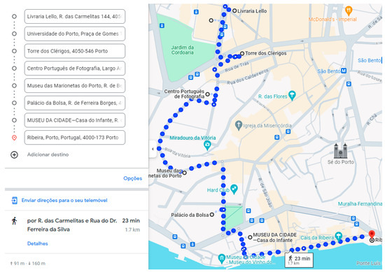
Figure 2.
Tourist route with identified POIs in Portuguese—Porto.
3.1.2. Chaves Route
The Chaves Route is composed of the following POI:
- Trajan’s Bridge: This roman bridge it is the oldest bridge in Portugal and one of the oldest in Europe, measuring around 150 m long and with 12 visible arches.
- Roman Thermal Baths: is considered the largest Roman thermal bath on the Iberian Peninsula and one of the largest in the Roman Empire.
- Church of Santa Maria Maior: The oldest church in Chaves, with the first references in 1259.
- Chaves Castle: With medieval characteristics and a rectangular plan, Chaves Castle, with its strategic location close to the border with Spain, was a crucial point of defense during the Middle Ages.
- Fountain of the People: The thermal waters were discovered by the Romans, even giving rise to the name of the city as Aquae Flaviae.
Figure 3 shows the path of the presented touristic route.
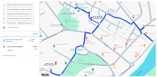
Figure 3.
Tourist route with identified POIs in Portuguese —Chaves.
The logo, shown in Figure 4, was created to reflect the essence and purpose of the solution. Centered on the idea of routes and paths, the logo evokes the feeling of movement and discovery, reinforcing the idea that the solution is oriented towards exploring tourist destinations. The app’s name, ARound Routes, highlights the two central aspects of the solution: AR and tourist routes.
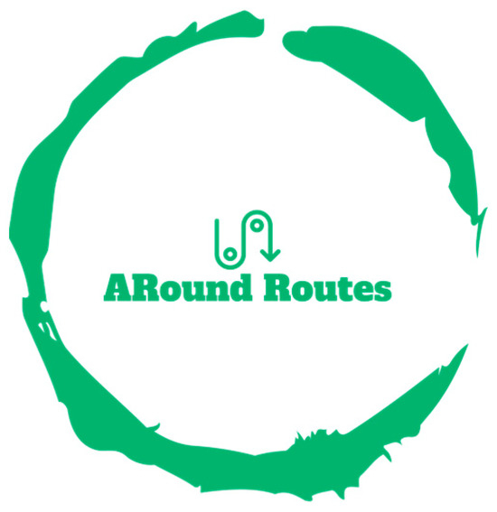
Figure 4.
ARound Routes logo.
For the development of the solution, Unity was selected for its versatility and powerful features, making it ideal for developing AR applications. Its dedicated AR tools simplify the integration of virtual elements like POIs, contextual information, and navigation guides. Additionally, Unity’s community and documentation serve as great help and support for development and problem solving.
3.2. Augmented Reality
Location-based AR was selected as the most suitable technology for the final solution. This choice ensures dynamic exploration by adapting to user movements, providing a personalized experience. Despite the small disadvantage in precision compared to marker-based AR, location-based AR was chosen due to its advantages in exploration, navigation, and adaptability. To integrate AR into the solution, the chosen development kit was ARCore. Developed by Google, ARCore supports both Android and iOS, and it accurately detects device position and orientation in relation to the environment, enabling realistic placement of virtual objects [31].
When developing the AR content UI for tourist route POIs, a consistent standard was created to ensure a cohesive and informative experience for users, composed of three main parts:
- Central Part: Displays the POI’s name and a description, serving as the focal point with an overview of what users can expect.
- Right Part: Provides detailed historical information, including history, relevant events, and cultural significance, allowing users to delve deeper into the POI’s context.
- Left Part: Shows interesting facts and additional insights that enrich the user’s experience.
Secondary elements like images, opening hours, and official websites may also be included. The color palette is tailored to the POI’s architectural style and historical context. Below, in Figure 5, is an example of a generic POI following this pattern, with the title and description in the center, historical information on the right, and curiosities on the left.
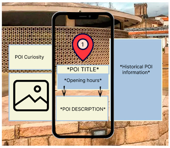
Figure 5.
Solution AR content in a generic POI.
3.3. Solution Main Features
3.3.1. Register and Login
Users are able to create a new account with an email and password and then log in to the application with these credentials. This way, the app can record the individual preferences of the user.
3.3.2. Choose and Create a Tourist Route
Users can choose from existing tourist routes or create personalized ones based on the available list of POIs. Each route offers options to view details, rate the POIs, and select a route for exploration. Figure 6 below shows the final application interface during the route selection process.
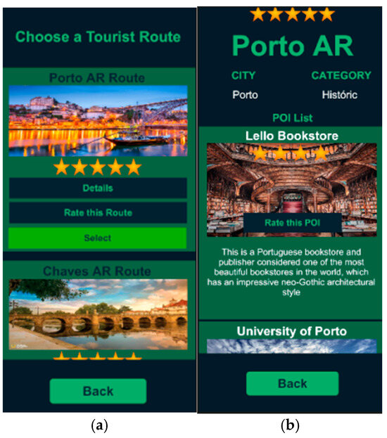
Figure 6.
(a) List of existing routes in the app; (b) route details in the app.
Route creation, on the other hand, offers users the possibility of creating their own specific adventures. This process is divided into two steps:
- Route definition, where users can choose a name, city, and category.
- Selection of POI, to select the POIs they want to include in their custom route.
Once a custom route is created, it is added to the list and is visible only to the user who created it.
3.3.3. Community Interaction
During the route exploration, users can take and store their own photos during explorations in a private gallery and access a public gallery to view and like photos shared by the community. This feature promotes the creation of a community, allowing users to connect with others, share moments, and seek inspiration for their own adventures.
3.3.4. Enrich Touristic Education
It is important to incorporate educational elements into the solution to enhance the overall tourist experience. By integrating educational information, the solution can provide tourists with a deeper understanding and appreciation of the places they visit. One effective way to deliver this educational content is through quizzes.
With this, the app includes a Tourist Quiz feature, offering users a fun and engaging way to learn more about the history and culture of points of interest.
3.3.5. Route Exploration
To improve the exploration process, the navigation through the route was improved with the help of GPS and AR, by adding virtual markers on the screen, reducing the possibility of confusion, and increasing the efficiency of their exploration. Intuitive AR visual markers guide tourists from one POI to another, providing a clear path. The AR navigation system also adjusts in real time based on the tourist’s location, ensuring that tourists can easily follow and navigate the route.
To address the challenge of information overload, the solution ensures that tourists receive only relevant information about each POI along their route, enhancing their understanding without overwhelming them. As tourists explore, dynamic textual information appears on their screens, providing insights into historical context, architectural features, and cultural significance. This approach focuses on delivering meaningful content adapted to enrich the exploration experience.
Overall, the AR route exploration feature provides an immersive and interactive journey for tourists. This development integrates ARCore for AR functionality, location services for user tracking, and content positioning to enhance accuracy and engagement throughout the exploration process.
Using platforms like Google Maps and Google Earth made it easy to determine the latitude and longitude of each POI. However, an additional challenge came up in determining the altitude of each POI. GeospatialAPI, an ARCore feature used to position AR elements, uses a reference system known as WGS84. This system assumes that the Earth is an Ellipsoid, that is, a mathematical model that represents the planet as a sphere slightly flattened at the poles and widened at the equator. On the other hand, Google Maps uses a more advanced reference system called EGM96, which employs a Geoid model to represent the Earth. A Geoid is an irregular surface that corresponds to mean sea level and is more accurate in describing the actual shape of the Earth.
Due to the differences between these two reference systems, the altitude provided may vary in representing the altitude of a given point on the Earth’s surface. Therefore, it was necessary to consider these differences to ensure an accurate and consistent representation of the AR content along the route. To do this, firstly, the altitude provided by Google Earth was used for each POI, based on the latitude and longitude coordinates. Then, using the same coordinates, an external website (https://geographiclib.sourceforge.io/cgi-bin/GeoidEval, accessed on 6 January 2025) was used to obtain the corresponding altitude value in the EGM96 model. Therefore, to represent the altitude of the POI in Unity, to the Google Earth altitude value, the EGM96 altitude value provided by the external website was added. Finally, so that the POI did not remain on the ground, 1.5 was added to the final value so that it remained 1.5 m above the ground.
The user’s coordinates were obtained by collecting the coordinates of the user’s own device. This was accomplished using the location features available on mobile devices, allowing the application to determine the user’s current geographic position. To ensure the app always has the user’s most updated coordinates, these are updated every 5 s.
3.3.6. Augmented Reality Exploration
ARCore services made AR implementation easier in the app, using ARAnchorManager for anchor content in the virtual environment. Anchors ensure stability and alignment with the real world, enabling accurate POI placement through the AR camera. This integration combines POI details, user location data, vectors, and orientation calculations for an immersive navigation experience.
Below, in Figure 7, are three images illustrating the app’s process of exploring a tourist route. The left image shows the route details and access to an audiobook for the current POI. Clicking “Explore Route” takes users to the center image, where AR markers guide the path, a compass pointing to the POI, and it displays distance and cardinal direction. The right image presents AR details specific to a POI.
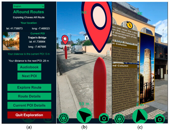
Figure 7.
(a) Exploration menu; (b) AR navigation; (c) AR POI exploration.
3.4. Comparison with Existing Solutions
This section presents a comparative analysis between the features of the proposed application, ARound Routes, and existing AR solutions for tourists. The following table (Table 2) summarizes the key functionalities, highlighting the innovations and advantages of this solution.
Table 2.
Comparison of ARound Routes features with existing AR tourist solutions.
In conclusion, this solution stands out in the AR tourist market by offering a range of innovative features that set it apart from existing solutions. Unlike many current AR apps, ARound Routes provides highly customizable routes, detailed AR navigation, rich educational content, and strong community interaction. Additionally, the app integrates gamification elements and multimedia features, enhancing user engagement and making the exploration process more interactive and enjoyable. These unique functionalities offer users an enriched, contextualized and personalized experience that surpasses the traditional tourist solutions, making ARound Routes a competitive option for modern tourists.
4. Validation and Discussion
This section outlines the validation process of the developed solution.
4.1. Methodology
4.1.1. Participants
A total of 31 participants were involved in the study, and they fulfilled all the following prerequisites:
- The participant had a smartphone (android).
- The participant had internet access.
- The participant allowed the use of location services on the smartphone.
- The participant was located either in the city of Chaves or in the city of Porto to explore the routes.
The study included a diverse group in terms of age and experience with AR systems. The age distribution was as follows:
- 26 participants between 12 and 27 years old.
- 2 participants between 28 and 43 years old.
- 3 participants between 44 and 59 years old.
In terms of experience with AR systems, only 12 out of the 31 had prior experience. These participants were divided into two groups to cover both solution routes, of which 16 of them tested the Chaves route, while 15 tested the Porto route.
4.1.2. Instruments
Two validation tools were applied: one for usability testing using the System Usability Scale (SUS), and an Impact Evaluation Questionnaire, designed to evaluate the app’s impact and whether it meets the established objectives.
4.2. Results
4.2.1. Usability Evaluation
The SUS is a widely used tool for assessing application usability, with questions rated on a Likert scale from 1 (strongly disagree) to 5 (strongly agree) [32]. The system usability score was calculated using the following steps:
- Convert each answer to points (1 to 5) using these rules:
- a.
- Subtract 1 for questions where 5 is positive (points—1).
- b.
- Subtract from 5 for questions where 5 is negative (5—points).
- Add the points for each user to get individual scores.
- Divide the total score by the maximum possible score, then multiply by 100 to get the final score.
- Average the final scores of all users to obtain the final SUS score.
The system usability score has an average of 68 points. If the final score of the solution is below this value, the application may have usability challenges [32]. In addition, some open answer questions were created, where the participants can give feedback and suggestions for improvements.
The SUS result was 86.7, which indicates an excellent usability score. Usability was an aspect highly focused throughout the development of the solution, as it is crucial in a tourism context for users to navigate routes without difficulty. Every feature was designed to be intuitive and user-friendly, and this high score confirms that the objective was successfully met.
The following figure (Figure 8) presents the average responses from participants regarding the usability of the AR navigation and AR exploration systems, which are central aspects of the solution. There were no negative responses, and only 11% of participants were neutral, while 59% expressed a positive opinion and 30% reported an extremely positive opinion. Based on these data, it is possible to conclude that most participants found the AR navigation and AR exploration experience very satisfactory, which reflects the application’s effectiveness in providing efficient exploration and navigation.
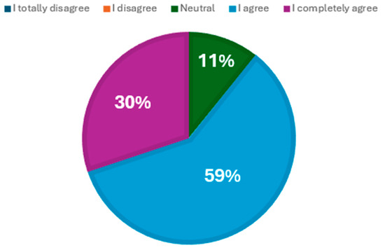
Figure 8.
Average responses per option in the usability of exploration and navigation.
4.2.2. Impact Assessment
Following the usability evaluation, a second questionnaire was conducted with the same participants to analyze the impact of the application and determine if it met its objectives. All 31 participants answered 59 questions covering several aspects of the solution. The results of the different objectives were consolidated in a single graph, as can be seen in Figure 9.
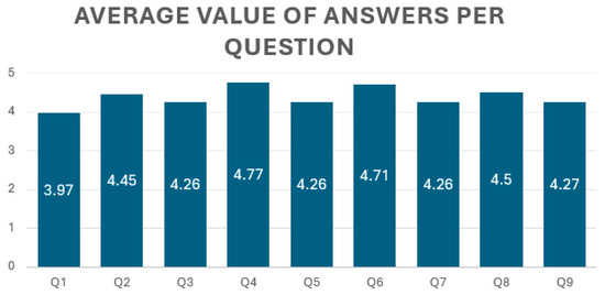
Figure 9.
Average value of answers per option in solution objectives.
In the graph, the y-axis values correspond to the average value of the participant’s responses per question, which can range from “I totally disagree” (value 1) to “I totally agree” (value 5). Each question is represented as follows:
- ○
- Q1: Did you feel that the ability to create personalized routes allowed you to have a more unique travel experience adapted to your interests?
- ○
- Q2: Do you think the educational elements available in the application were useful in learning more about tourist destinations?
- ○
- Q3: Do you think AR navigation has made your exploration more efficient?
- ○
- Q4: Did the app effectively reduce the excess of unnecessary information, providing you with useful and relevant content during your exploration of the tourist route?
- ○
- Q5: Did the app succeed in promoting local tourism by encouraging you to explore and learn more about destinations, history, and culture?
- ○
- Q6: Did the app enrich your experience in exploring a tourist route by providing useful and contextual information?
- ○
- Q7: Do you think that augmented reality in the app was useful in improving your experience when exploring tourist routes?
- ○
- Q8: Did you feel that the application provided an enriching tourist experience in Chaves?
- ○
- Q9: Did you feel that the application provided an enriching tourist experience in Porto?
This graph illustrates that across all main objectives, the average answers were consistently high, with the lowest being 3.97 for question Q1, and the highest at 4.77 for question Q4. The data reflect an extremely positive reception in achieving its objectives.
With this, based on the results obtained, it is possible to conclude that the solution objectives were all successfully achieved. The AR app provided a more personalized and contextualized tourist experience, facilitating the exploration of tourist routes and making them more efficient, easier, and immersive for tourists. Additionally, the integration of educational elements enriched the experience by providing important information about the history, culture, and significance of the destinations visited, further enhancing the app’s applicability across multiple routes. The promotion of local tourism was also successfully accomplished, as evidenced by the encouragement of tourists to explore and learn more about destinations, their history, and their culture. Finally, the app demonstrated effectiveness in reducing excess unnecessary information, providing useful, relevant, and contextualized content along tourist routes, thus solidifying its efficacy in catering to several tourist preferences and needs across different locations.
4.3. Results Discussion
The study hypothesis sought to confirm that by implementing AR technology on tourist routes, the exploration of these routes became more efficient, immersive, and contextualized.
Towards the analysis of the hypothesis, a final question was included in the questionnaire, in which participants were asked about their agreement with the following statement: “This application, by using augmented reality technology on tourist routes, made the exploration of these routes more efficient, immersive, and contextualized”.
As is shown in Figure 10, the results revealed an almost unanimous vote in favor, with 38.7% agreeing and 58.1% completely agreeing, totaling 96.8% positive votes. Only 3.2% (1 participant) expressed a neutral opinion. It was also possible to observe the following (Table 3):
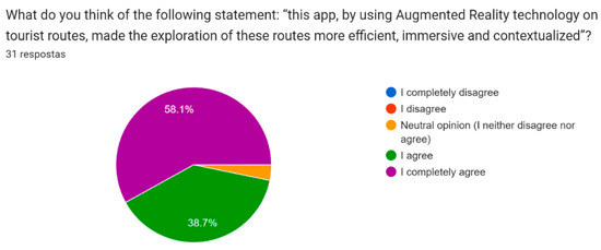
Figure 10.
Result of the solution of the hypothesis question.
Table 3.
Analysis of the Wilcoxon test.
- The average answer rate was 4.55, indicating a very positive assessment of the effectiveness of AR technology.
- The median of the data was 5, reflecting that most participants completely agreed with the statement.
- The mode was 5, meaning that the “completely agree” response was the most common, appearing 18 times.
- The standard deviation was 0.56, suggesting a relatively low dispersion of the data around the mean.
However, to provide a robust validation of the observed data, a formal statistical test was performed. For this purpose, the utilization of the Wilcoxon test with one sample is justified, primarily due to the non-normal distribution of the dataset.
With a p-value of 0.0000009313 at a significance level of 0.05, the data did not conform to a normal distribution. Therefore, since the value of 4 is the minimum value for the hypothesis to be positive, a unilateral test on the left side was chosen:
- H0 (null hypothesis): the average is equal to 4.
- H1 (alternative hypothesis): The average is less than 4.
With this, the results are as follows in the next table:
With a p-value of 0.99, which is much higher than the significance level (0.05), the null hypothesis was not rejected. This suggests that there is no statistically significant evidence that the average for the question is less than 4.
Based on the statistical results of this test, since 4 is the minimum positive value for the hypothesis to be true, it is possible to confirm that the hypothesis of the research has been validated. This solution, using AR technology in tourist routes, has been proven to improve the efficiency, immersion, and contextualization of the exploration of these itineraries.
5. Conclusions
This research was motivated by the desire to address the challenges tourists face when navigating unfamiliar routes. This journey began with a comprehensive analysis of the issues that affect conventional methods of tourist exploration. Along with the study of the state of the art, including the analysis of existing solutions and technologies in the tourism sector, the problem was analyzed and understood in order to design a solution that could improve the way tourists explore tourist routes.
The analysis revealed several key challenges. Traditional tour guides often overload users with too much information, making navigation and exploration difficult. They also lack specific information about the POI and rarely provide personalized experiences suited to individual interests and preferences. With this, the goal was to design and develop a solution that would improve the exploration of tourist routes, encouraging engagement and delivering more contextual experiences about POIs. Through research, design and development, an application named ARound Routes was created to meet the initial objectives. This app takes advantage of AR to provide users with immersive experiences by smoothly overlaying digital information into the physical world.
The research hypothesis, stating that the implementation of AR technology would increase the efficiency, immersion, and contextualization of tourist exploration, was validated through user testing and statistical analysis. The positive feedback and results obtained from participants confirmed the effectiveness of the solution in achieving the intended objectives. Augmented reality proved to be a good choice to solve the established problem, being well received even by the most traditional users. This was due to its ability to provide a more immersive and interactive experience, making exploration more captivating. Furthermore, the technology allowed for a better understanding and contextualization of POIs by directly integrating them into users’ environment, creating a deeper sense of immersion.
For future work, the app can benefit from several enhancements based on user feedback. Implementing informative messages for errors, such as incorrect passwords or emails, will improve the user experience by providing clear feedback and reducing frustration. Improving and the erratic behavior of the compass is also important, as it will improve navigation and increase the tourist’s overall satisfaction when exploring the routes. Expanding the variety and quantity of POIs available within the application emerged as another key area for future development. By increasing the number of POIs, users will have access to a more diverse exploration, allowing them to discover a wider range of attractions and points of interest in their chosen destinations. Additionally, participants expressed interest in further developing the functionality for creating personalized routes. Enhancing this feature will unlock the full potential of the application, providing users with tailored experiences aligned with their specific interests and preferences.
Furthermore, recognizing the application’s significant potential to support multiple tourist routes, future efforts will focus on expanding its availability to cover other cities and destinations.
We also acknowledge the limitation in the number of participants and will strive to extend the validation to a higher number of participants and to more locations.
Author Contributions
Conceptualization, M.C. and C.V.d.C.; methodology, M.C. and C.V.d.C.; software, M.C.; validation, M.C. and C.V.d.C.; formal analysis, M.C.; investigation, M.C.; data curation, M.C.; writing—original draft preparation, M.C.; writing—review and editing, C.V.d.C.; supervision, C.V.d.C. All authors have read and agreed to the published version of the manuscript.
Funding
This research received no external funding.
Institutional Review Board Statement
Ethical review and approval were waived for this study due to no sensitive individual data being published.
Informed Consent Statement
Informed consent was obtained from all subjects involved in the study.
Data Availability Statement
Data supporting reported results are available following a request to the authors.
Conflicts of Interest
The authors declare no conflicts of interest.
References
- Conceito.de. Conceito da Rota Turística. March 2016. Available online: https://conceito.de/rota-turistica (accessed on 1 November 2023).
- WTCC. Economic Impact Research. 2023. Available online: https://wttc.org/research/economic-impact (accessed on 11 November 2023).
- Cibilić, I.; Posloncec-Petric, V.; Tominic, K. Implementing Augmented Reality in Tourism. In Proceedings of the ICA; Copernicus Publications: Göttingen, Germany, 2021; Volume 4, p. 5. [Google Scholar] [CrossRef]
- Carter, K. Trip. Advisor Study Reveals 42% of Travelers Worldwide Use Smartphones to Plan or Book Their Trips. June 2015. Available online: https://ir.tripadvisor.com/news-releases/news-release-details/tripadvisor-study-reveals-42-travelers-worldwide-use-smartphones (accessed on 5 October 2023).
- Barten, M. 13 Key Technology Trends Emerging in the Travel & Tourism Industry. January 2025. Available online: https://www.revfine.com/technology-trends-travel-industry/ (accessed on 9 February 2025).
- Syed, T.A. In-Depth Review of Augmented Reality: Tracking Technologies, Development Tools, AR Displays, Collaborative AR, and Security Concerns. Sensors 2023, 23, 146. [Google Scholar] [CrossRef]
- Butchart, B. Augmented Reality for Smartphones; UKOLN University of Bath: Bath, UK, 2011. [Google Scholar]
- Li, D.; Shang, Y. Design and Implementation of Augmented Reality Browser for Mobile Terminal. In IOP Conference Series: Materials Science and Engineering; IOP Publishing: Bristol, UK, 2019; Volume 490, p. 042017. [Google Scholar] [CrossRef]
- Peddie, J. Types of Augmented Reality. In Augmented Reality: Where We Will All Live; Springer International Publishing: Cham, Switzerland, 2017; Volume 23, pp. 29–46. [Google Scholar]
- Bahur, H. What is Marker-Based AR? 2023. Available online: https://www.educative.io/answers/what-is-marker-based-ar (accessed on 20 October 2023).
- Altynpara, E.; Chabanovska, D. The Fullest Guide on Location-Based AR Apps Development. 2023. Available online: https://www.cleveroad.com/blog/location-based-ar-apps-development/ (accessed on 20 October 2023).
- Poghosyan, S. Section 9. In Pedagogy Learning-Oriented Augmented Reality Technology; National Polytechnic University of Armenia: Yerevan, Armenia, 2019; pp. 42–46. Available online: https://www.researchgate.net/publication/331181344_Section_9_Pedagogy_LEARNING-ORIENTED_AUGMENTED_REALITY_TECHNOLOGY (accessed on 9 February 2025).
- Morosova, A. Augmented Reality in Travel: How AR Can Enrich Tourists’ Experiences While on Vacation. Available online: https://www.jasoren.com/augmented-reality-in-travel/ (accessed on 1 September 2024).
- Pratisto, E.; Thompson, N.; Potdar, V. Immersive Technologies for Tourism: A Systematic Review. Inf. Technol. Tour. 2022, 24, 181–219. [Google Scholar] [CrossRef]
- Genc, R. The Impact of Augmented Reality (AR) Technology on Tourist Satisfaction. In Handbook of Research on Electronic Marketing in Emerging Economies; Edward Elgar Publishing: Camberley, UK, 2018; pp. 109–116. [Google Scholar] [CrossRef]
- Rahimi, R.; Hassan, A.; Tekin, O. Augmented Reality Apps for Tourism Destination Promotion. In Apps Management and E-Commerce Transactions in Real-Time; IGI Global: Hershey, PA, USA, 2017. [Google Scholar] [CrossRef]
- Cranmer, E.E.; Dieck, M.C.; Fountoulaki, P. Exploring the value of augmented reality for Tourism. Tour. Manag. Perspect. 2020, 35, 100672. [Google Scholar] [CrossRef]
- Brito, C. Augmented reality applied in tourism mobile applications. In Proceedings of the 2015 Second International Conference on eDemocracy & eGovernment (ICEDEG), Quito, Ecuador, 8–10 April 2015. [Google Scholar] [CrossRef]
- Ozkul, E. Augmented Reality Applications in Tourism. Int. J. Contemp. Tour. Res. 2019, 3, 107–122. [Google Scholar] [CrossRef]
- Chung, N.; Han, H.; Joun, Y. Tourists’ intention to visit a destination: The role of augmented reality (AR) application for a heritage site. Comput. Hum. Behav. 2015, 50, 588–599. [Google Scholar] [CrossRef]
- Ivankov, A. Advantages and Disadvantages of Augmented Reality. 2023. Available online: https://www.profolus.com/topics/advantages-and-disadvantages-of-augmented-reality/ (accessed on 22 October 2023).
- Warren, M. AR for Navigation—What You Should Know. Available online: https://www.bairesdev.com/blog/ar-for-navigation-what-you-should-know/ (accessed on 21 October 2023).
- Pranoto, H.; Saputra, P.P.; Sadekh, M.; Darmadi, H.; Yanfi, Y. Augmented reality navigation application to promote tourism to local state attraction “Lawang Sewu”. Procedia Comput. Sci. 2023, 216, 757–764. [Google Scholar] [CrossRef]
- Martinez, P. Augmented Reality and Tourism: The New Travel Experience. 2023. Available online: https://www.onirix.com/augmented-reality-and-tourism-the-new-travel-experience/ (accessed on 21 October 2023).
- Zumoko, A.R. Tourist Guide. Available online: https://www.zumoko.com/solutions/ar-tourist-guide/ (accessed on 21 October 2023).
- Seo, B.-K.; Kim, K.; Park, J.-I. Augmented Reality-Based On-Site Tour Guide: A Study in Gyeongbokgung. In Proceedings of the 2010 International Conference on Augmented Reality, Queenstown, New Zealand, 8–9 November 2010; Springer: Berlin/Heidelberg, Germany, 2010; pp. 276–285. [Google Scholar]
- Louise, C. Art Of London Launch The New Augmented Gallery. 2021. Available online: https://onin.london/art-of-london-launch-the-new-augmented-gallery/ (accessed on 22 October 2023).
- Gong, Z.; Wang, R.; Xia, G. Augmented Reality (AR) as a Tool for Engaging Museum Experience: A Case Study on Chinese Art Pieces. Digital 2022, 2, 33–45. [Google Scholar] [CrossRef]
- Ritchie, B.W.; Carr, N.; Cooper, C.P. Managing Educational Tourism; Channel View Publications: Clevedon, UK, 2003. [Google Scholar]
- Kleftodimos, A.; Evagelou, A.; Gkoutzios, S.; Matsiola, M.; Vrigkas, M.; Yannacopoulou, A.; Triantafillidou, A.; Lappas, G. Creating Location-Based Augmented Reality Games and Immersive Experiences for Touristic Destination Marketing and Education. Computers 2023, 12, 227. [Google Scholar] [CrossRef]
- Google, ARCore. Available online: https://developers.google.com/ar (accessed on 15 February 2025).
- Teixeira, F. O que é o SUS (System Usability Scale) e Como usá-lo em seu Site. 2015. Available online: https://brasil.uxdesign.cc/o-que-%C3%A9-o-sus-system-usability-scale-e-como-us%C3%A1-lo-em-seu-site-6d63224481c8 (accessed on 3 May 2024).
Disclaimer/Publisher’s Note: The statements, opinions and data contained in all publications are solely those of the individual author(s) and contributor(s) and not of MDPI and/or the editor(s). MDPI and/or the editor(s) disclaim responsibility for any injury to people or property resulting from any ideas, methods, instructions or products referred to in the content. |
© 2025 by the authors. Licensee MDPI, Basel, Switzerland. This article is an open access article distributed under the terms and conditions of the Creative Commons Attribution (CC BY) license (https://creativecommons.org/licenses/by/4.0/).