A Burned Area Mapping Algorithm for Chinese FengYun-3 MERSI Satellite Data
Abstract
:1. Introduction
2. Materials and Methods
2.1. Study Area
2.2. Data
2.3. Selection of Training Pixels
2.3.1. VI Time-Series Analysis
2.3.2. Temporal Texture Analysis
2.3.3. Selection of Training Pixels
2.4. Classification
2.4.1. Classification by SVM Classifier
2.4.2. Use of Vegetation Indexes in the SVM Classifier
3. Results
4. Discussion
5. Conclusions
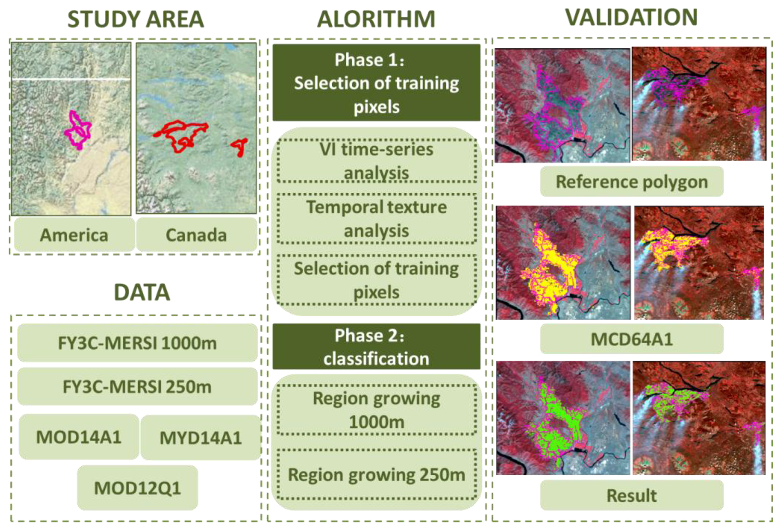
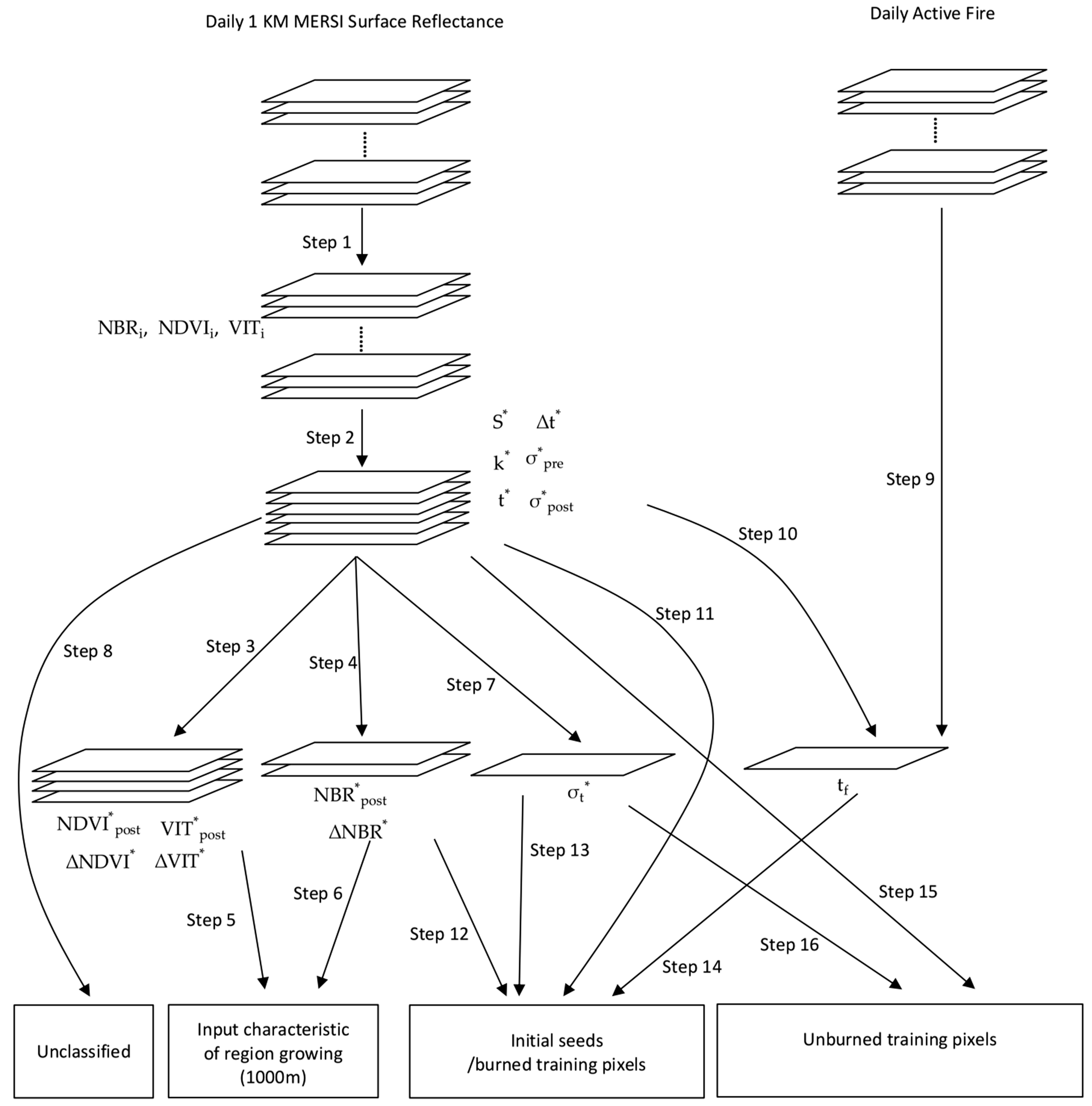
- The selection of initial burned seeds is similar to the method proposed by Giglio [16], especially in terms of the definition of the separability of the VIs. One difference between the two methods is that we proposed the use of more than one VI as a burned area feature, based on the characteristics of MERSI data. The other main difference is that between the region-growing methods used in the two papers. The method we proposed used an SVM and the region-growing method simultaneously. These could make the method more suitable for burned area mapping using MERSI data.
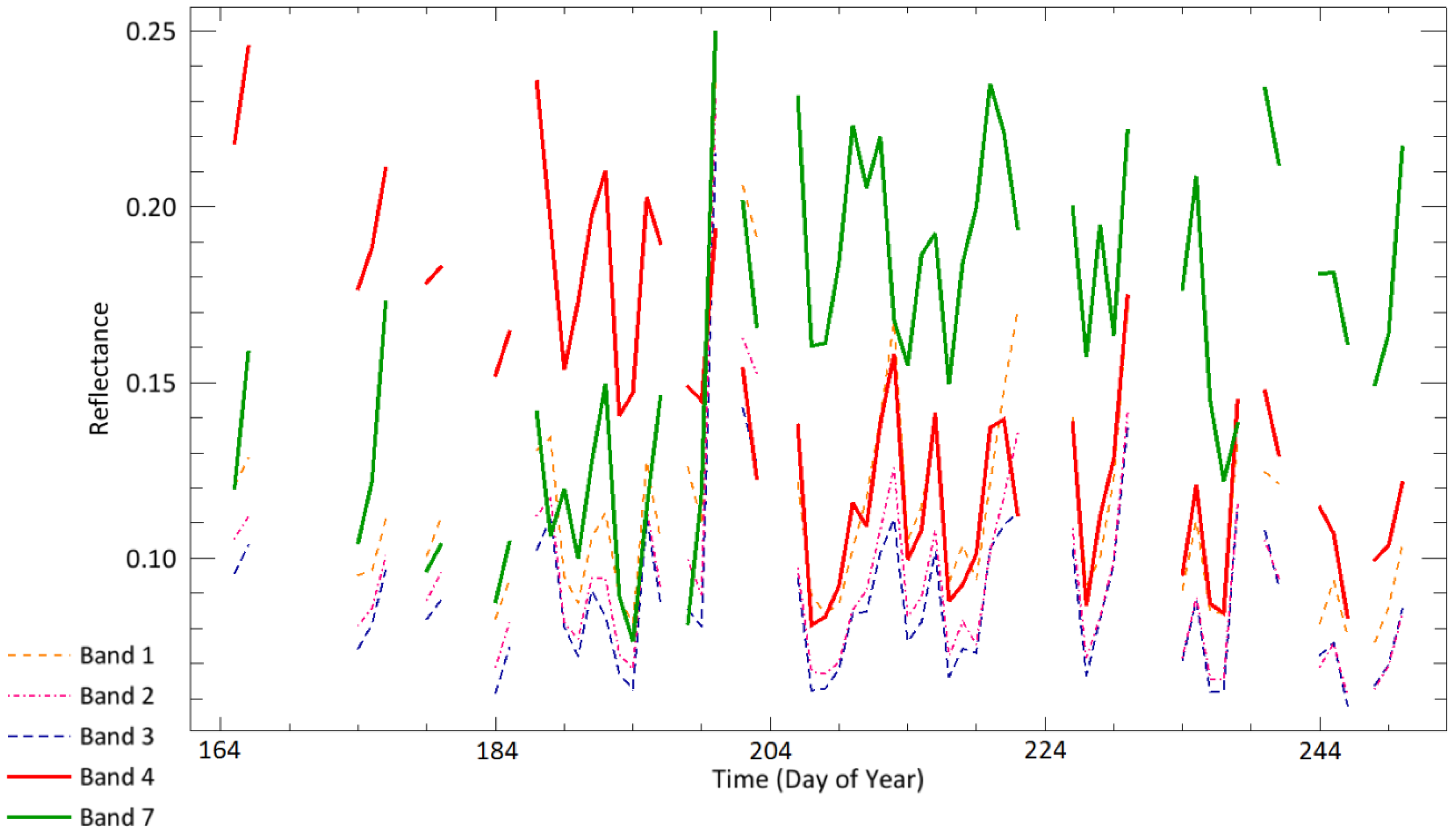
- Regarding the selection of a burned area index for FY-3C MERSI, we analyzed time series of different indices and performed a quantitative analysis of these indices in the burned and unburned areas. We then selected several features that were appropriate for use with FY-3C MERSI data in subsequent analysis.
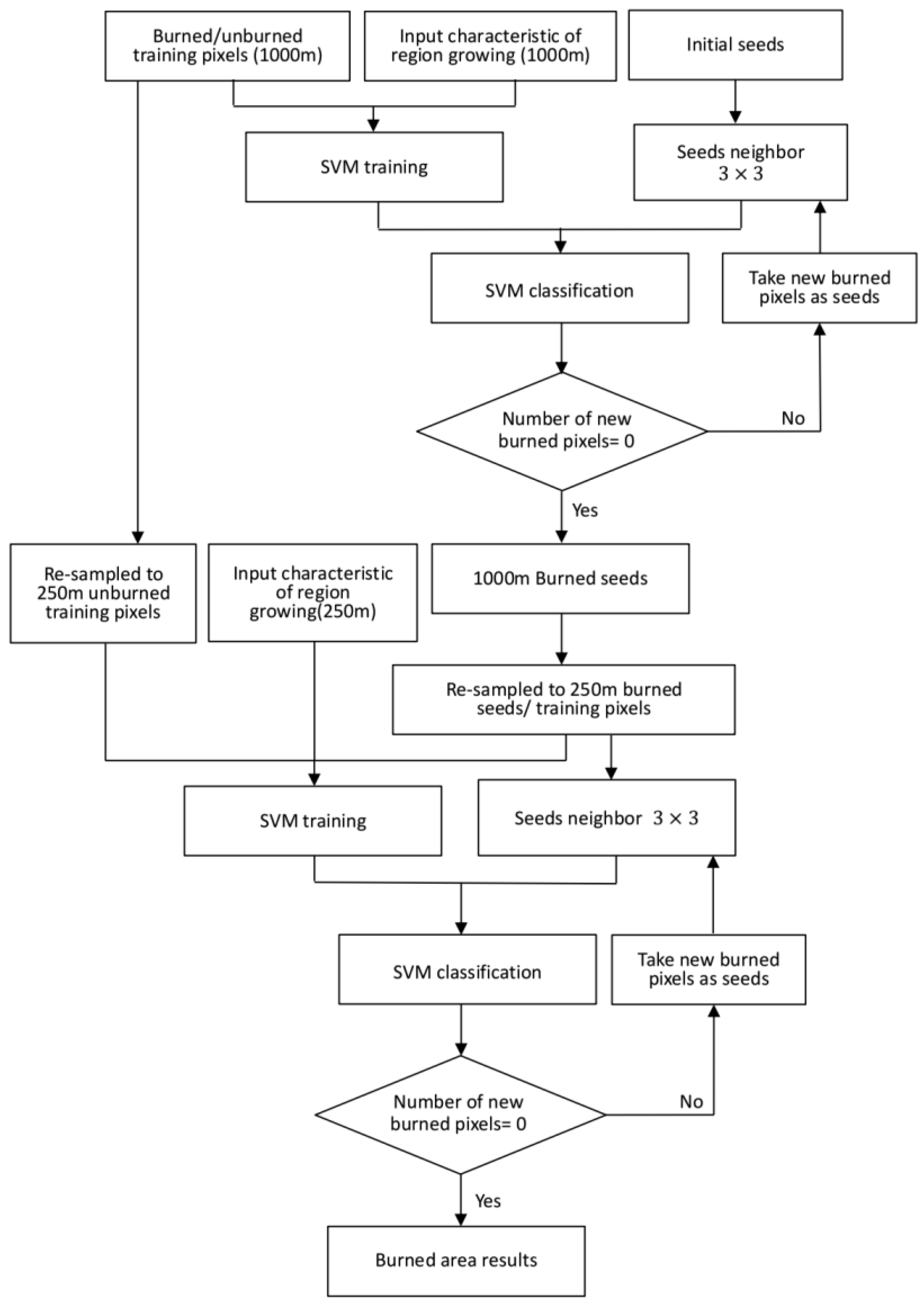
- Regarding the extraction of a burned area using the SVM and the region-growing method, SVM and region growing are common image classification and image segmentation algorithms. The combination of these two methods makes regional growth criterion more flexible and can produce more accurate burned area mapping results.
- The algorithm used a combination of multi-temporal data and single-scenes. First we used 1 km multi-temporal data to extract the characteristic parameters and to obtain preliminary burned area classification results. We then used individual scenes from the time series of 250-m resolution MERSI data and carried out the classification again, thereby reducing the influence of the MERSI geo-location errors and producing more accurate burned area mapping results.
- MERSI data have shown great potential for filling the gaps in the imaging of burned areas of the Earth’s surface. Some MODIS products were used in the proposed method like the daily active fire product MOD14A1/MYD14A1 and the land cover product MOD12Q1 because of their high reliability and ready availability. In addition to MOD12Q1, many other land cover products or vegetation indices can be used to extract vegetation regions. FY-3 also produces series of active fire products derived from VIRR data. In the future, it should be possible to use an improved FY-3 active fire product with the proposed method. As both the Terra and Aqua satellites have exceeded their mission lifetimes, it may then be possible to use MERSI and other data to fill the gaps in the imaging of burned areas.
Acknowledgments
Author Contributions
Conflicts of Interest
References
- Crutzen, P.J.; Andreae, M.O. Biomass burning in the tropics: Impact on atmospheric chemistry and biogeochemical cycles. Science 1991, 250, 1669–1678. [Google Scholar] [CrossRef] [PubMed]
- French, N.H.F.; Goovaerts, P.; Kasischke, E.S. Uncertainty in estimating carbon emissions from boreal forest fires. J. Geophys. Res. Atmos. 2004, 109, 646–650. [Google Scholar] [CrossRef]
- Seiler, W.; Crutzen, P.J. Estimates of gross and net fluxes of carbon between the biosphere and the atmosphere from biomass burning. Clim. Chang. 1980, 2, 207–247. [Google Scholar] [CrossRef]
- Corona, P.; Lamonaca, A.; Chirici, G. Remote sensing support for post fire forest management. iForest Biogeosc. For. 2008, 1, 6–12. [Google Scholar] [CrossRef]
- Koutsias, N.; Karteris, M. Burned area mapping using logistic regression modeling of a single post-fire landsat-5 thematic mapper image. Int. J. Remote Sens. 2000, 21, 673–687. [Google Scholar] [CrossRef]
- Smith, A.M.S.; Drake, N.A.; Wooster, M.J.; Hudak, A.T.; Holden, Z.A.; Gibbons, C.J. Production of landsat ETM+ reference imagery of burned areas within southern african savannahs: Comparison of methods and application to MODIS. Int. J. Remote Sens. 2007, 28, 2753–2775. [Google Scholar] [CrossRef]
- Stroppiana, D.; Bordogna, G.; Carrara, P.; Boschetti, M.; Boschetti, L.; Brivio, P.A. A method for extracting burned areas from landsat TM/ETM+ images by soft aggregation of multiple spectral indices and a region growing algorithm. ISPRS J. Photogramm. Remote Sens. 2012, 69, 88–102. [Google Scholar] [CrossRef]
- Koutsias, N.; Pleniou, M.; Mallinis, G.; Nioti, F.; Sifakis, N.I. A rule-based semi-automatic method to map burned areas: Exploring the usgs historical landsat archives to reconstruct recent fire history. Int. J. Remote Sens. 2013, 34, 7049–7068. [Google Scholar] [CrossRef]
- Polychronaki, A.; Gitas, I.Z. Burned area mapping in greece using SPOT-4 HRVIR images and object-based image analysis. Remote Sens. 2012, 78, 424–438. [Google Scholar] [CrossRef]
- Garrity, S.R.; Allen, C.D.; Brumby, S.P.; Gangodagamage, C.; Mcdowell, N.G.; Cai, D.M. Quantifying tree mortality in a mixed species woodland using multitemporal high spatial resolution satellite imagery. Remote Sens. Environ. 2013, 129, 54–65. [Google Scholar] [CrossRef]
- Dragozi, E.; Gitas, I.; Stavrakoudis, D.; Theocharis, J. Burned area mapping using support vector machines and the fuzcoc feature selection method on VHR ikonos imagery. Remote Sens. 2014, 6, 12005–12036. [Google Scholar] [CrossRef]
- Cahoon, D.R., Jr.; Stocks, B.J.; Levine, J.S.; Cofer, W.R., III; Pierson, J.M. Satellite analysis of the severe 1987 forest fires in northern china and southeastern siberia. J. Geophys. Res. Atmos. 1994, 99, 18627–18638. [Google Scholar] [CrossRef]
- Fraser, R.H.; Li, Z.; Cihlar, J. Hotspot and NDVI differencing synergy (hands): A new technique for burned area mapping over boreal forest. Remote Sens. Environ. 2000, 74, 362–376. [Google Scholar] [CrossRef]
- Gitas, I.Z.; Mitri, G.H.; Ventura, G. Object-based image classification for burned area mapping of creus cape, spain, using NOAA-AVHRR imagery. Remote Sens. Environ. 2004, 92, 409–413. [Google Scholar] [CrossRef]
- Roy, D.; Descloitres, J.; Alleaume, S. The MODIS fire products. Remote Sens. Environ. 2002, 83, 244–262. [Google Scholar]
- Giglio, L.; Loboda, T.; Roy, D.P.; Quayle, B.; Justice, C.O. An active-fire based burned area mapping algorithm for the MODIS sensor. Remote Sens. Environ. 2009, 113, 408–420. [Google Scholar] [CrossRef]
- Ruiz, J.A.M.; Lázaro, J.R.G.; Cano, I.D.Á.; Leal, P.H. Burned area mapping in the north american boreal forest using terra-MODIS LTDR (2001–2011): A comparison with the MCD45A1, MCD64A1 and BA GEOLAND-2 products. Remote Sens. 2014, 6, 815–840. [Google Scholar] [CrossRef]
- Silva, J.M.N.; Pereira, J.M.C.; Cabral, A.I.; Sá, A.C.L.; Vasconcelos, M.J.P.; Mota, B.; Grégoire, J.M. An estimate of the area burned in southern africa during the 2000 dry season using spot-vegetation satellite data. J. Geophys. Res. Atmos. 2003, 108, 8498. [Google Scholar] [CrossRef]
- Tansey, K.; Grégoire, J.M.; Stroppiana, D.; Sousa, A.; Silva, J.; Pereira, J.M.C.; Boschetti, L.; Maggi, M.; Brivio, P.A.; Fraser, R.; et al. Vegetation burning in the year 2000: Global burned area estimates from spot vegetation data. J. Geophys. Res. Atmos. 2004, 109, 449–464. [Google Scholar] [CrossRef]
- Alonso-Canas, I.; Chuvieco, E. Global burned area mapping from ENVISAT-MERIS and MODIS active fire data. Remote Sens. Environ. 2015, 163, 140–152. [Google Scholar] [CrossRef]
- Hoekman, D.H.; Vissers, M.A.M.; Wielaard, N. Palsar wide-area mapping of borneo: Methodology and map validation. IEEE J. Sel. Top. Appl. Earth Obs. Remote Sens. 2010, 3, 605–617. [Google Scholar] [CrossRef]
- Stroppiana, D.; Azar, R.; Calò, F.; Pepe, A.; Imperatore, P.; Boschetti, M.; Silva, J.M.N.; Brivio, P.A.; Lanari, R. Integration of optical and sar data for burned area mapping in mediterranean regions. Remote Sens. 2015, 7, 1320–1345. [Google Scholar] [CrossRef]
- Giglio, L.; Randerson, J.T.; Van, D.W.G.; Collatz, G.J.; Kasibhatla, P.S.; Morton, D.; Defries, R.S. The Global Fire Emissions Database (GFED4) Burned Area Data Set. In Proceedings of the AGU Fall Meeting, San Francisco, CA, USA, 3–7 December 2012. [Google Scholar]
- Roy, D.P.; Lewis, P.E.; Justice, C.O. Burned area mapping using multi-temporal moderate spatial resolution data—A bi-directional reflectance model-based expectation approach. Remote Sens. Environ. 2002, 83, 263–286. [Google Scholar] [CrossRef]
- Tansey, K.; Beston, J.; Hoscilo, A.; Page, S.E.; Hernández, C.U.P. Relationship between MODIS fire hot spot count and burned area in a degraded tropical peat swamp forest in central Kalimantan, Indonesia. J. Geophys. Res. Atmos. 2008, 113, 2036–2044. [Google Scholar] [CrossRef]
- Eva, H.; Lambin, E.F. Burnt area mapping in central africa using ATSR data. Int. J. Remote Sens. 1998, 19, 3473–3497. [Google Scholar] [CrossRef]
- Grégoire, J.-M.; Tansey, K.; Silva, J.M.N. The gba2000 initiative: Developing a global burnt area database from spot-vegetation imagery. Int. J. Remote Sens. 2003, 24, 1369–1376. [Google Scholar] [CrossRef]
- Pereira, J.M.C.; Vasconcelos, M.J.P.; Sousa, A.M. A Rule-Based System for Burned Area Mapping in Temperate and Tropical Regions Using NOAA/AVHRR Imagery; Springer Netherlands, 2000; pp. 215–232. [Google Scholar]
- Stroppiana, D.; Tansey, K.; Gregoire, J.M.; Pereira, J.M.C. An algorithm for mapping burnt areas in australia using spot-vegetation data. IEEE Trans. Geosci. Remote Sens. 2003, 41, 907–909. [Google Scholar] [CrossRef]
- Simon, M.; Plummer, S.; Fierens, F.; Hoelzemann, J.J.; Arino, O. Burnt area detection at global scale using ATSR-2: The globscar products and their qualification. J. Geophys. Res. Atmos. 2004, 109, 2890–2898. [Google Scholar] [CrossRef]
- Cao, X.; Chen, J.; Matsushita, B.; Imura, H.; Wang, L. An automatic method for burn scar mapping using support vector machines. Int. J. Remote Sens. 2009, 30, 577–594. [Google Scholar] [CrossRef]
- Lanorte, A.; Danese, M.; Lasaponara, R.; Murgante, B. Multiscale mapping of burn area and severity using multisensor satellite data and spatial autocorrelation analysis. Int. J. Appl. Earth Obs. Geoinf. 2013, 20, 42–51. [Google Scholar] [CrossRef]
- Roy, D.P.; Jin, Y.; Lewis, P.E.; Justice, C.O. Prototyping a global algorithm for systematic fire-affected area mapping using MODIS time series data. Remote Sens. Environ. 2005, 97, 137–162. [Google Scholar] [CrossRef]
- Giglio, L.; Werf, G.R.V.D.; Randerson, J.T.; Collatz, G.J. Global estimation of burned area using MODIS active fire observations. Chem. Phys. 2014, 6, 957–974. [Google Scholar]
- Chuvieco, E.; Englefield, P.; Trishchenko, A.P.; Luo, Y. Generation of long time series of burn area maps of the boreal forest from NOAA–AVHRR composite data. Remote Sens. Environ. 2008, 112, 2381–2396. [Google Scholar] [CrossRef]
- Toukiloglou, P.; Gitas, I.Z.; Katagis, T. An automated two-step NDVI-based method for the production of low-cost historical burned area map records over large areas. Int. J. Remote Sens. 2014, 35, 2713–2730. [Google Scholar] [CrossRef]
- Hardtke, L.A.; Blanco, P.D.; Valle, H.F.D.; Metternicht, G.I.; Sione, W.F. Semi-automated mapping of burned areas in semi-arid ecosystems using MODIS time-series imagery. Int. J. Appl. Earth Obs. Geoinf. 2015, 38, 25–35. [Google Scholar] [CrossRef]
- Huete, A.R. A soil-adjusted vegetation index (SAVI). Remote Sens. Environ. 1988, 25, 295–309. [Google Scholar] [CrossRef]
- Garcı́A, M.; Chuvieco, E. Assessment of the potential of SAC-C/MMRS imagery for mapping burned areas in spain. Remote Sens. Environ. 2004, 92, 414–423. [Google Scholar] [CrossRef]
- Fraser, R.H.; Li, Z.; Landry, R. Spot vegetation for characterizing boreal forest fires. Int. J. Remote Sens. 2000, 21, 3525–3532. [Google Scholar] [CrossRef]
- Kaufman, Y.J.; Remer, L.A. Detection of forests using mid-IR reflectance: An application for aerosol studies. IEEE Trans. Geosci. Remote Sens. 1994, 32, 672–683. [Google Scholar] [CrossRef]
- Holden, Z.A.; Smith, A.M.S.; Morgan, P.; Rollins, M.G.; Gessler, P.E. Evaluation of novel thermally enhanced spectral indices for mapping fire perimeters and comparisons with fire atlas data. Int. J. Remote Sens. 2005, 26, 4801–4808. [Google Scholar] [CrossRef]
- Veraverbeke, S.; Harris, S.; Hook, S. Evaluating spectral indices for burned area discrimination using MODIS/ASTER (MASTER) airborne simulator data. Remote Sens. Environ. 2011, 115, 2702–2709. [Google Scholar] [CrossRef]
- Zhao, W.H.; Shan, H.; Zhong, R.X. The normalized difference thermal index (NDTI) for the modis fire detection. Remote Sens. Technol. Appl. 2007, 22, 403–409. [Google Scholar]
- Wu, S.; Liu, C. A New Model for Fire Forecast. Proceedngs of Earth Resources and Environmental Remote Sensing/GIS Applications, Toulouse, France, 20 September 2010. [Google Scholar]
- Wang, Z. Research and evaluation of the algorithm of land surface fire detection based on FY3-VIRR data. Fire Saf. Sci. 2011, 20, 140–145. [Google Scholar]
- Bastarrika, A.; Alvarado, M.; Artano, K.; Martinez, M.; Mesanza, A.; Torre, L.; Ramo, R.; Chuvieco, E. Bams: A tool for supervised burned area mapping using landsat data. Remote Sens. 2014, 6, 12360–12380. [Google Scholar] [CrossRef]
- Friedl, M.A.; Mciver, D.K.; Hodges, J.C.F.; Zhang, X.Y.; Muchoney, D.; Strahler, A.H.; Woodcock, C.E.; Gopal, S.; Schneider, A.; Cooper, A.; et al. Global land cover mapping from modis: Algorithms and early results. Remote Sens. Environ. 2002, 83, 287–302. [Google Scholar] [CrossRef]
- Overmars, K.P.; Koning, G.H.J.D.; Veldkamp, A. Spatial autocorrelation in multi-scale land use models. Ecol. Model. 2003, 164, 257–270. [Google Scholar] [CrossRef]
- Manish, M. Autocorrelation simulation studies for horizontal transmission of ethno- medicinal-knowledge related with two corporeal systems. Int. Res. J. Biol. Sci. 2013, 2, 18–29. [Google Scholar]
- Mcfeeters, S.K. The use of the normalized difference water index (NDWI) in the delineation of open water features. Int. J. Remote Sens. 1996, 17, 1425–1432. [Google Scholar] [CrossRef]
- Chuvieco, E.; Ventura, G.; Martín, M.P.; Gómez, I. Assessment of multitemporal compositing techniques of MODIS and AVHRR images for burned land mapping. Remote Sens. Environ. 2005, 94, 450–462. [Google Scholar] [CrossRef]
- Huete, A.; Didan, K.; Miura, T.; Rodriguez, E.P.; Gao, X.; Ferreira, L.G. Overview of the radiometric and biophysical performance of the MODIS vegetation indices. Remote Sens. Environ. 2002, 83, 195–213. [Google Scholar] [CrossRef]
| Band | Wavelength (μm) | SNR 1 or Neρ 2 or NEΔT 3 @ 4 Specified Input | IFOV 5 @ s.s.p 6 (m) |
|---|---|---|---|
| 1 | 0.465–0.475 | 100 @ 50% albedo | 250/1000 |
| 2 | 0.500–0.700 | 100 @ 50% albedo | 250/1000 |
| 3 | 0.600–0.700 | 100 @ 50% albedo | 250/1000 |
| 4 | 0.815–0.915 | 100 @ 50% albedo | 250/1000 |
| 5 | 8.55–13.55 | 0.3 K @ 300 K | 250/1000 |
| 7 | 2.080–2.180 | 0.07% | 1000 |
| Study Area | Proposed Algorithm | MODIS MCD64A1 | ||||
|---|---|---|---|---|---|---|
| OE (%) | CE (%) | Kappa | OE (%) | CE (%) | Kappa | |
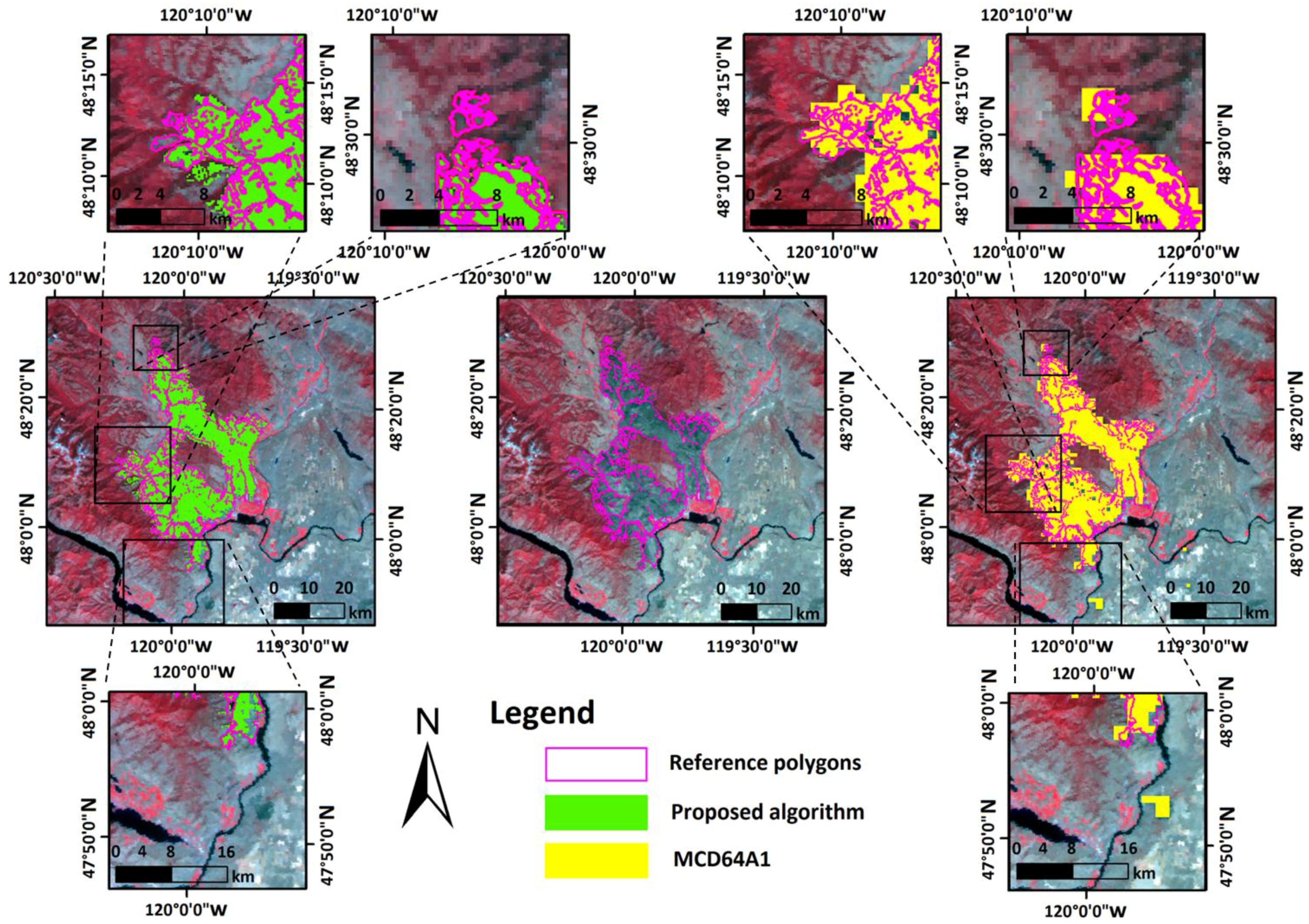
| America | 11.32 | 14.77 | 0.8680 | 6.67 | 20.58 | 0.8567 |
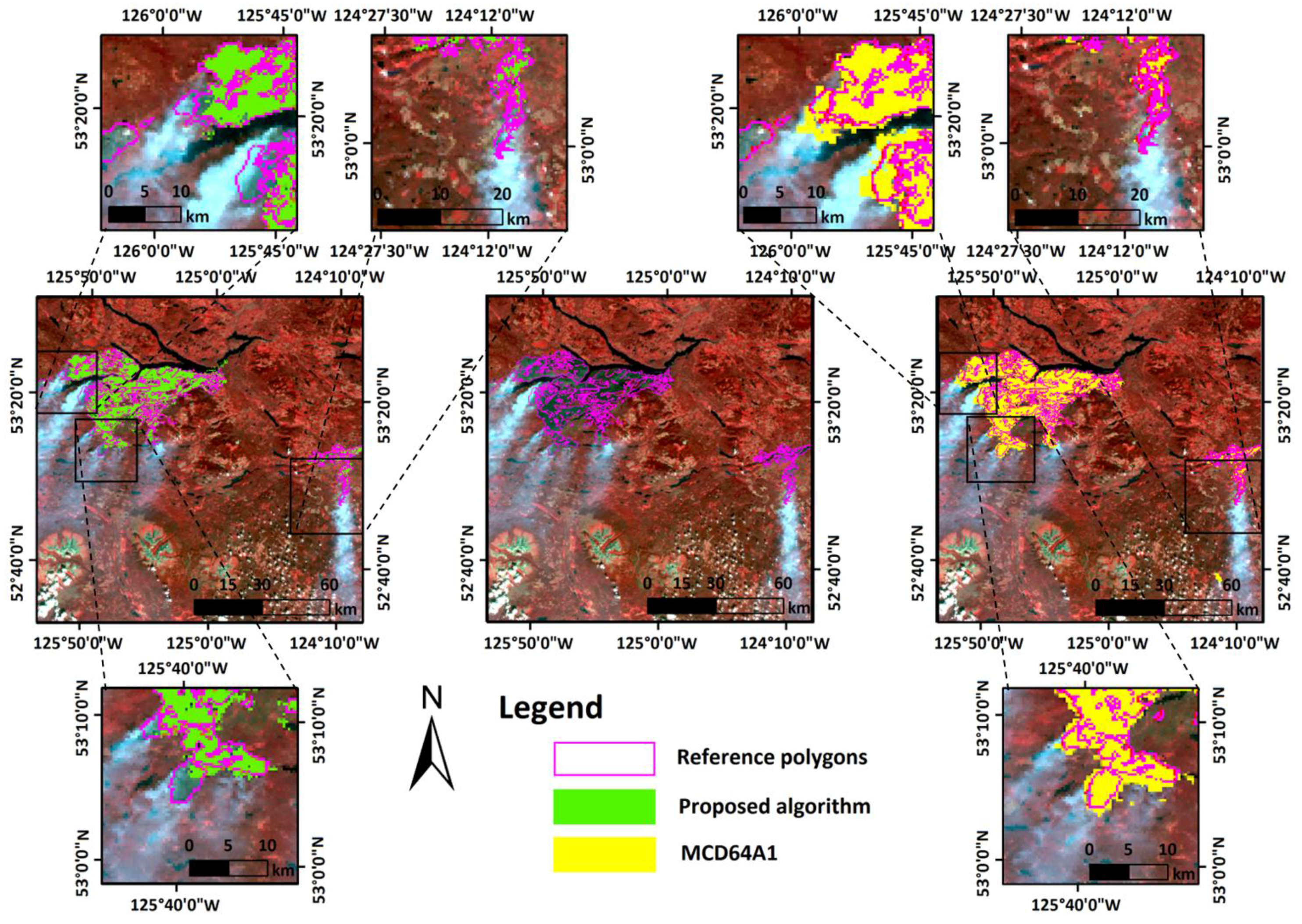
| Canada | 17.21 | 23.94 | 0.7914 | 16.44 | 31.00 | 0.6893 |
© 2017 by the authors. Licensee MDPI, Basel, Switzerland. This article is an open access article distributed under the terms and conditions of the Creative Commons Attribution (CC BY) license (http://creativecommons.org/licenses/by/4.0/).
Share and Cite
Shan, T.; Wang, C.; Chen, F.; Wu, Q.; Li, B.; Yu, B.; Shirazi, Z.; Lin, Z.; Wu, W. A Burned Area Mapping Algorithm for Chinese FengYun-3 MERSI Satellite Data. Remote Sens. 2017, 9, 736. https://doi.org/10.3390/rs9070736
Shan T, Wang C, Chen F, Wu Q, Li B, Yu B, Shirazi Z, Lin Z, Wu W. A Burned Area Mapping Algorithm for Chinese FengYun-3 MERSI Satellite Data. Remote Sensing. 2017; 9(7):736. https://doi.org/10.3390/rs9070736
Chicago/Turabian StyleShan, Tianchan, Changlin Wang, Fang Chen, Qinchun Wu, Bin Li, Bo Yu, Zeeshan Shirazi, Zhengyang Lin, and Wei Wu. 2017. "A Burned Area Mapping Algorithm for Chinese FengYun-3 MERSI Satellite Data" Remote Sensing 9, no. 7: 736. https://doi.org/10.3390/rs9070736
APA StyleShan, T., Wang, C., Chen, F., Wu, Q., Li, B., Yu, B., Shirazi, Z., Lin, Z., & Wu, W. (2017). A Burned Area Mapping Algorithm for Chinese FengYun-3 MERSI Satellite Data. Remote Sensing, 9(7), 736. https://doi.org/10.3390/rs9070736


