Experiences from Large-Scale Forest Mapping of Sweden Using TanDEM-X Data

 ,
,  ,
,  and
and 
Abstract
1. Introduction
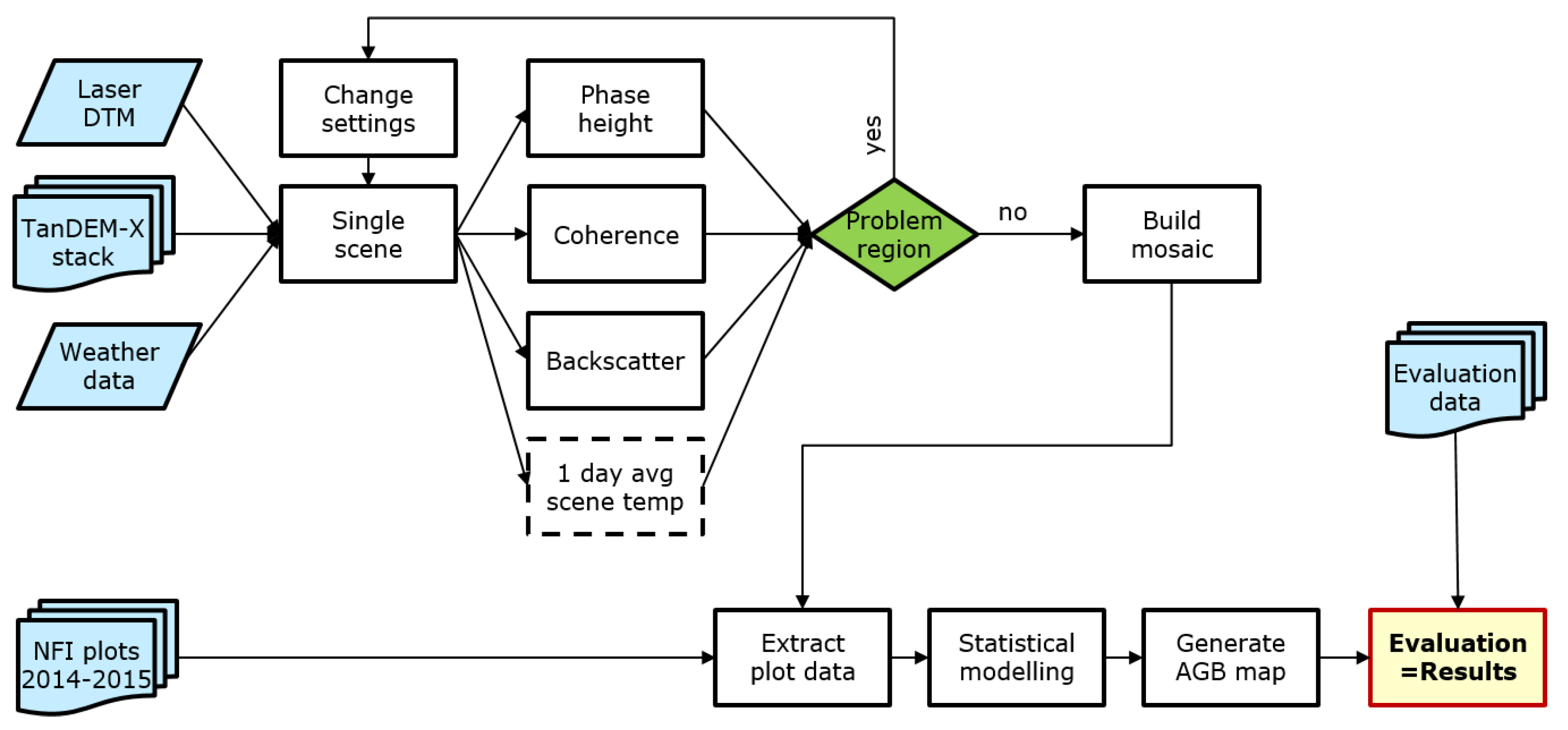
2. Material and Methods
2.1. Material
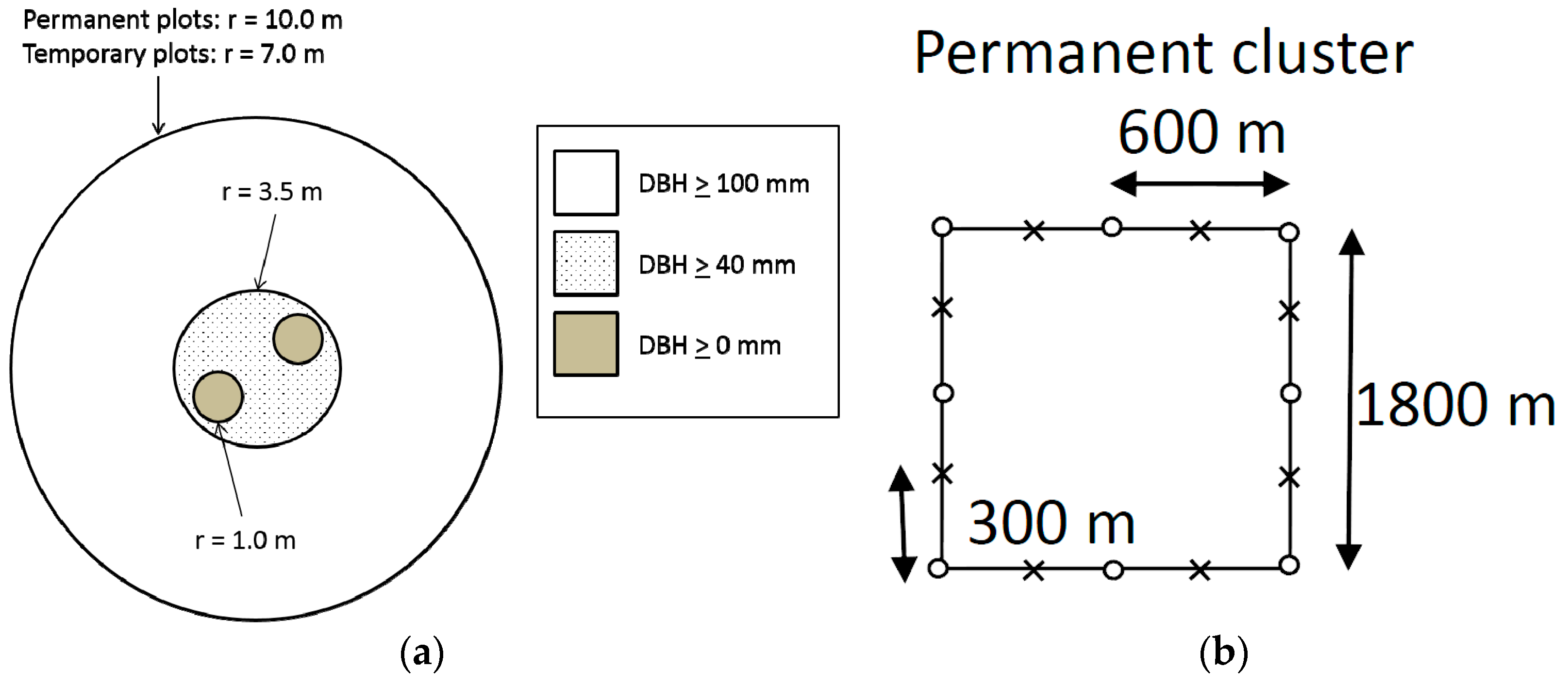
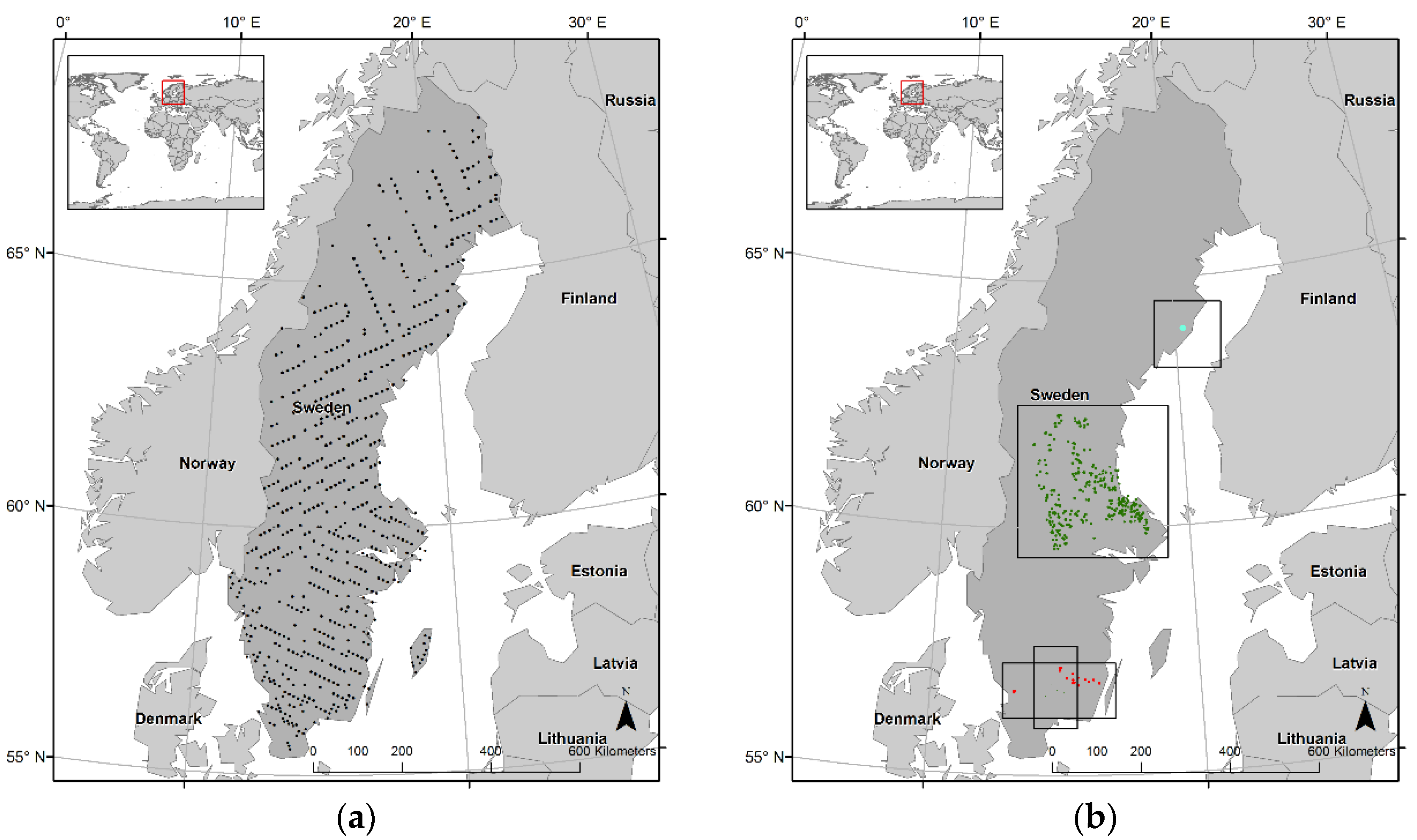
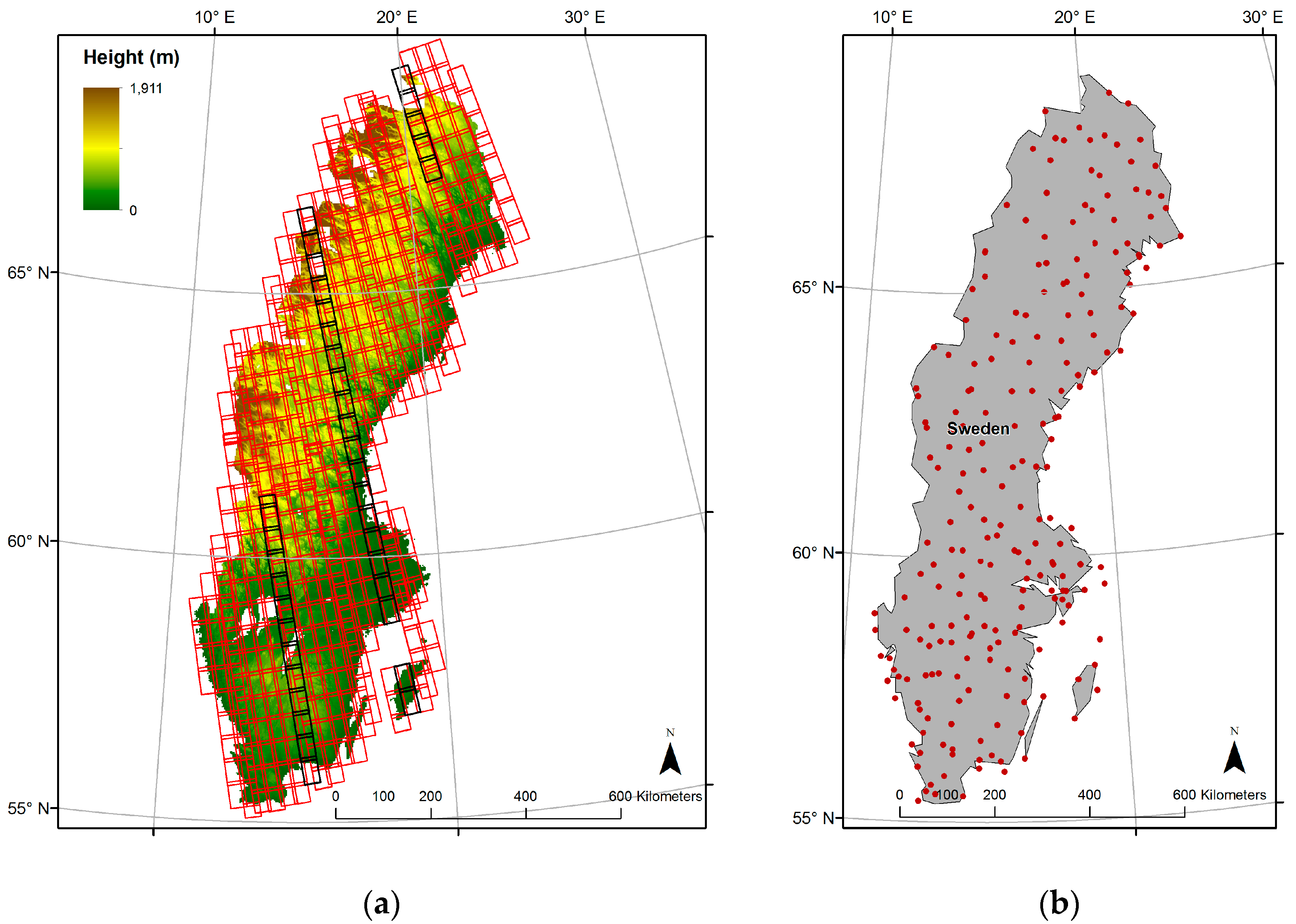
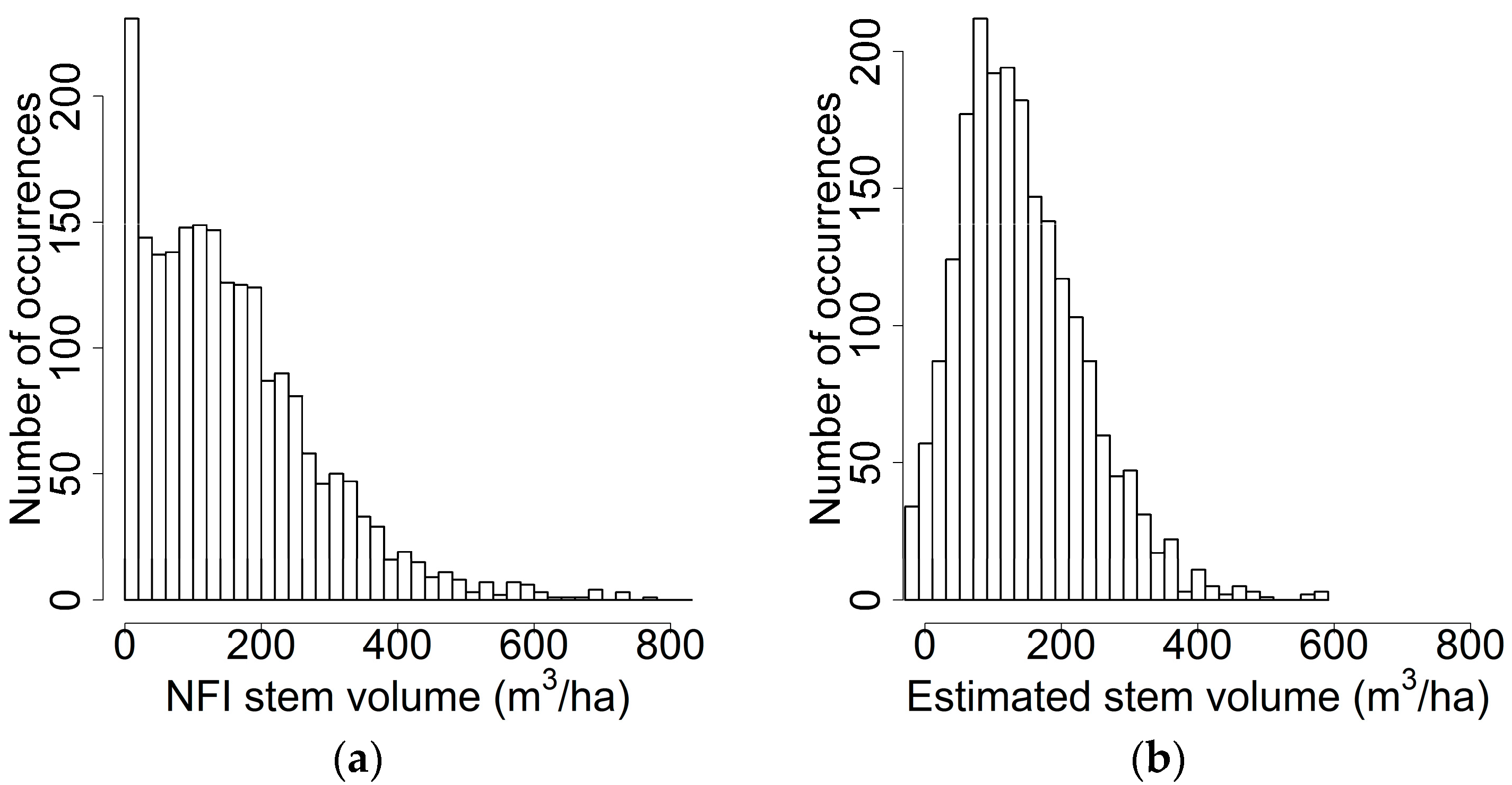
2.1.1. Field Data
2.1.2. Remote Sensing Data
2.1.3. Metrological Data
2.2. Field Data Processing
2.3. SAR Data Processing
2.3.1. Computation of Backscatter Raster
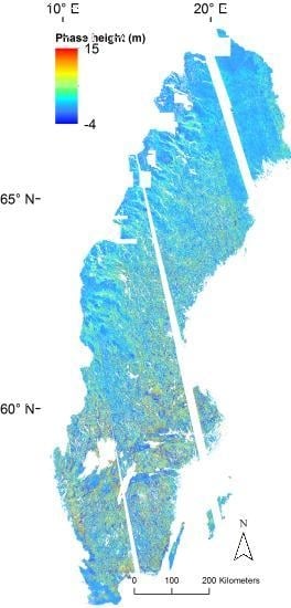
2.3.2. Interferometric Phase Height
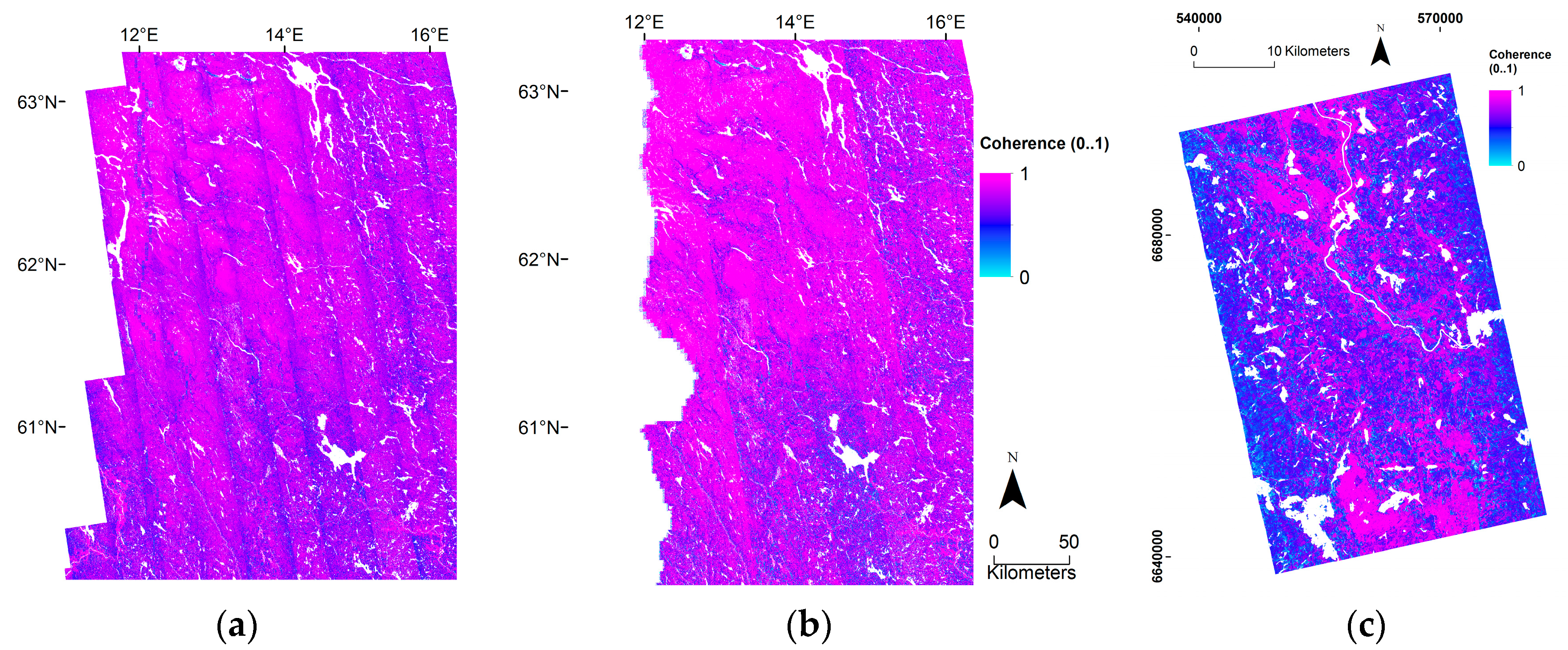
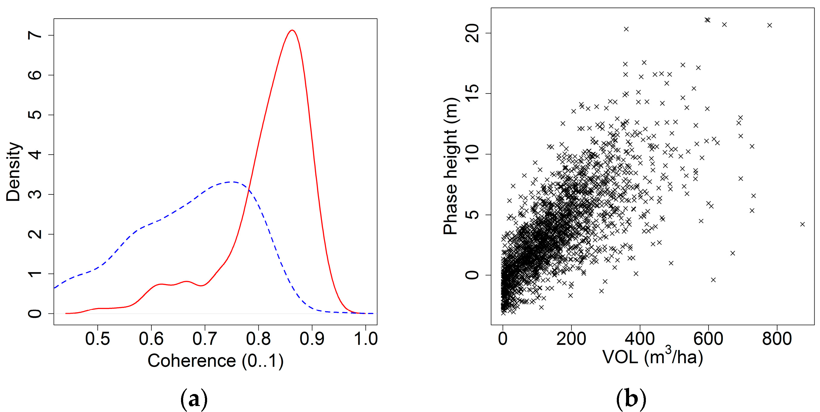
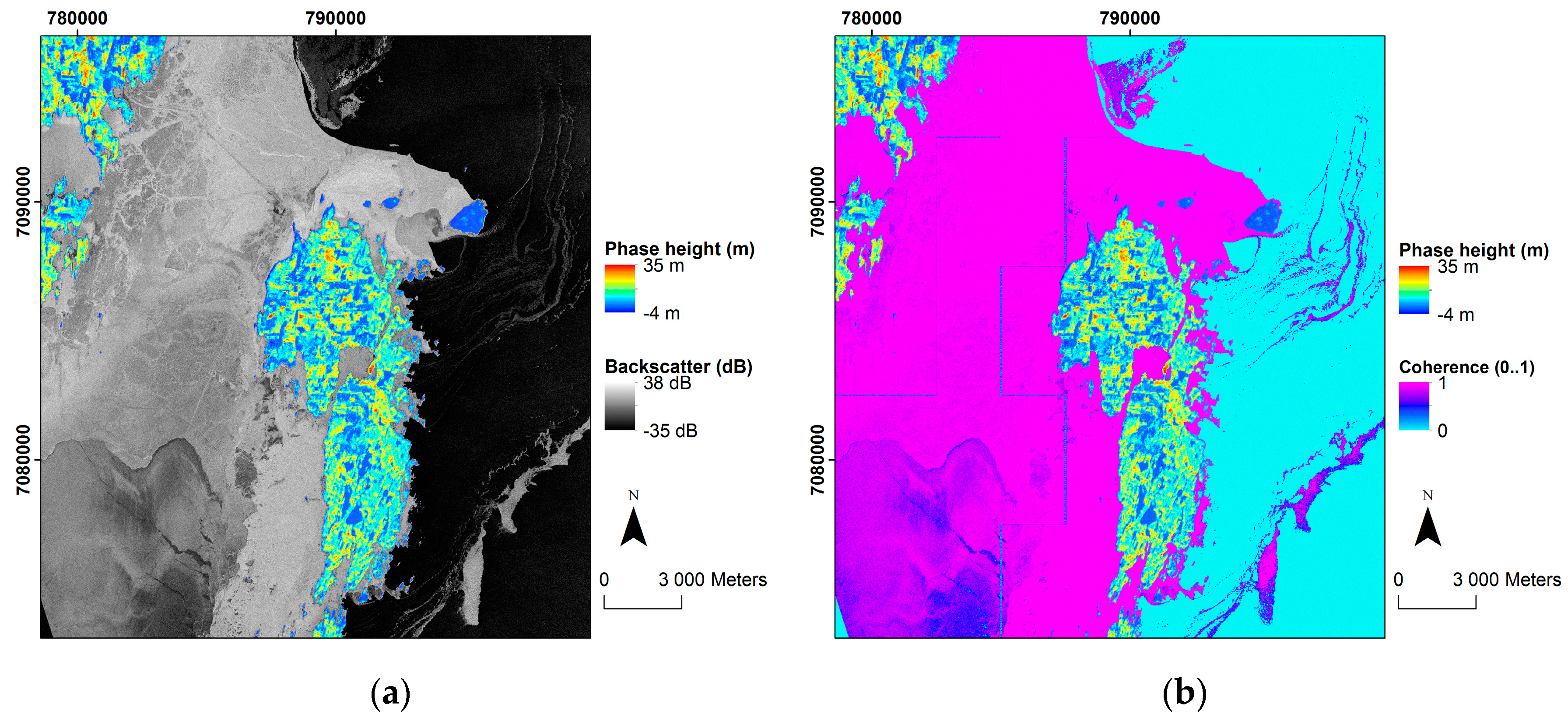
2.3.3. Computation of Coherence
2.3.4. Derivation of Water Mask
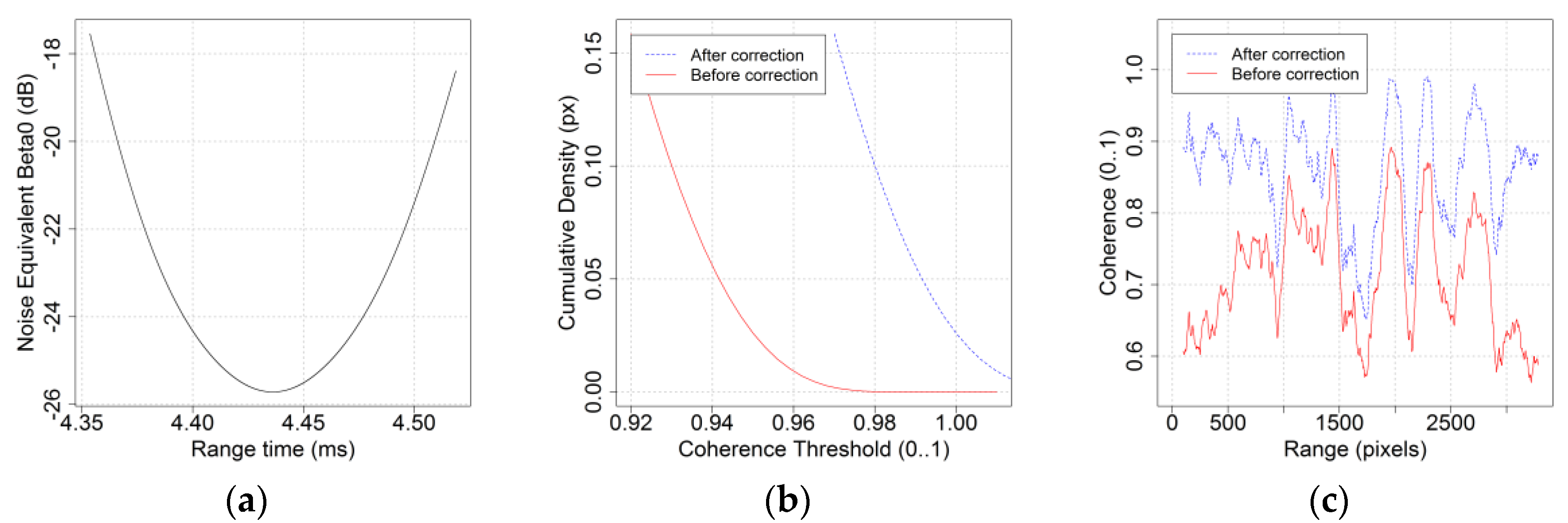
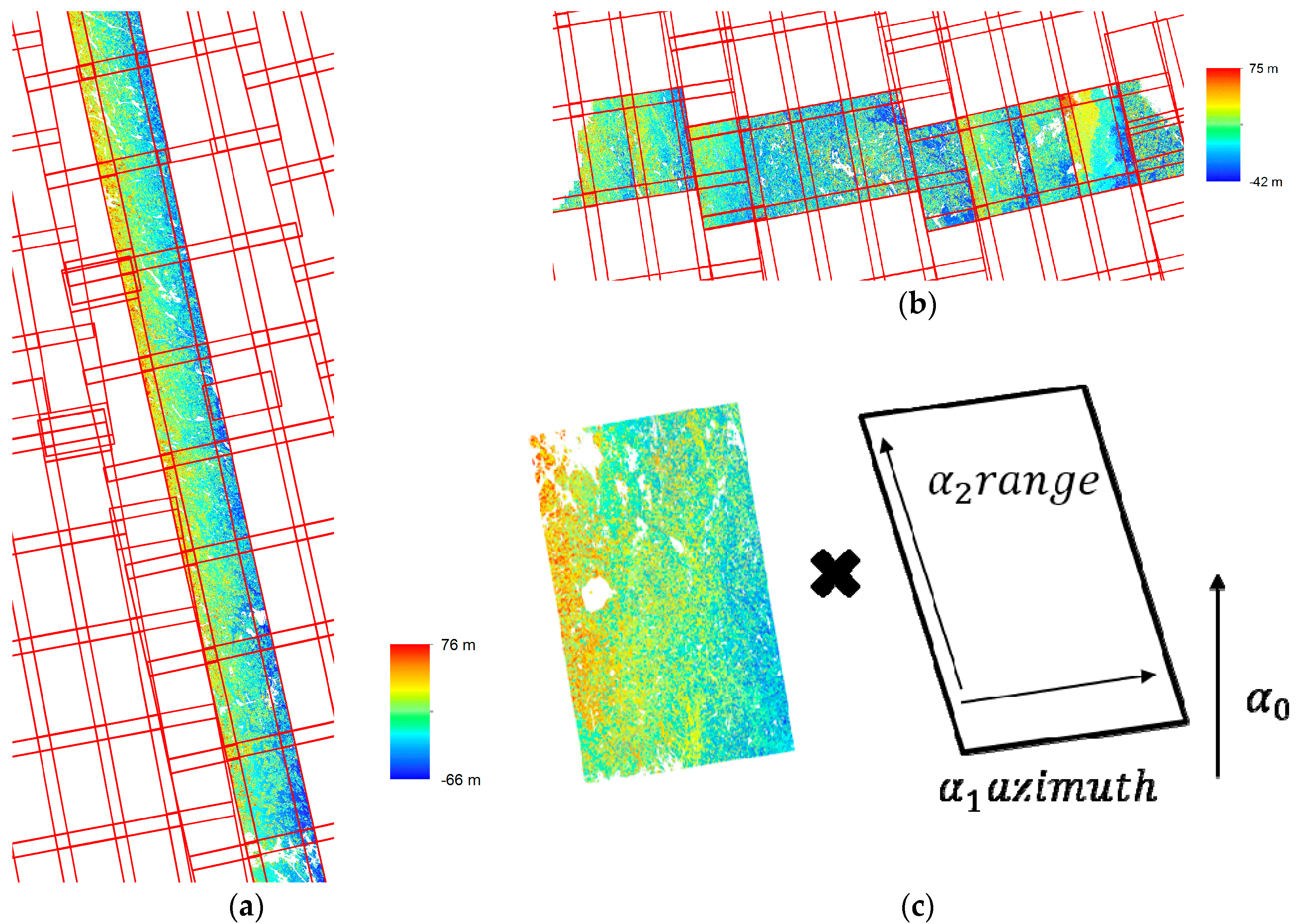
2.3.5. Geo-Location
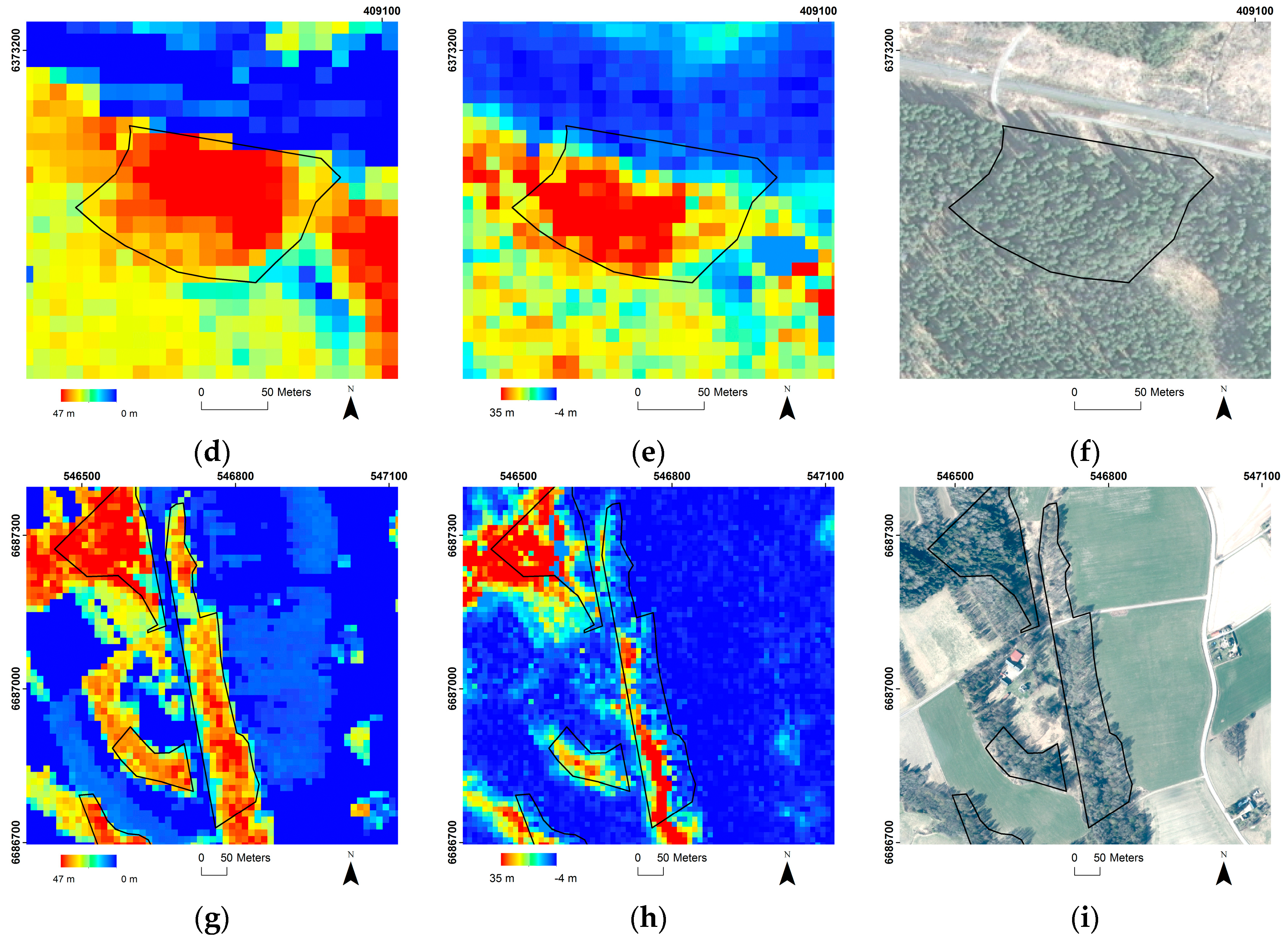
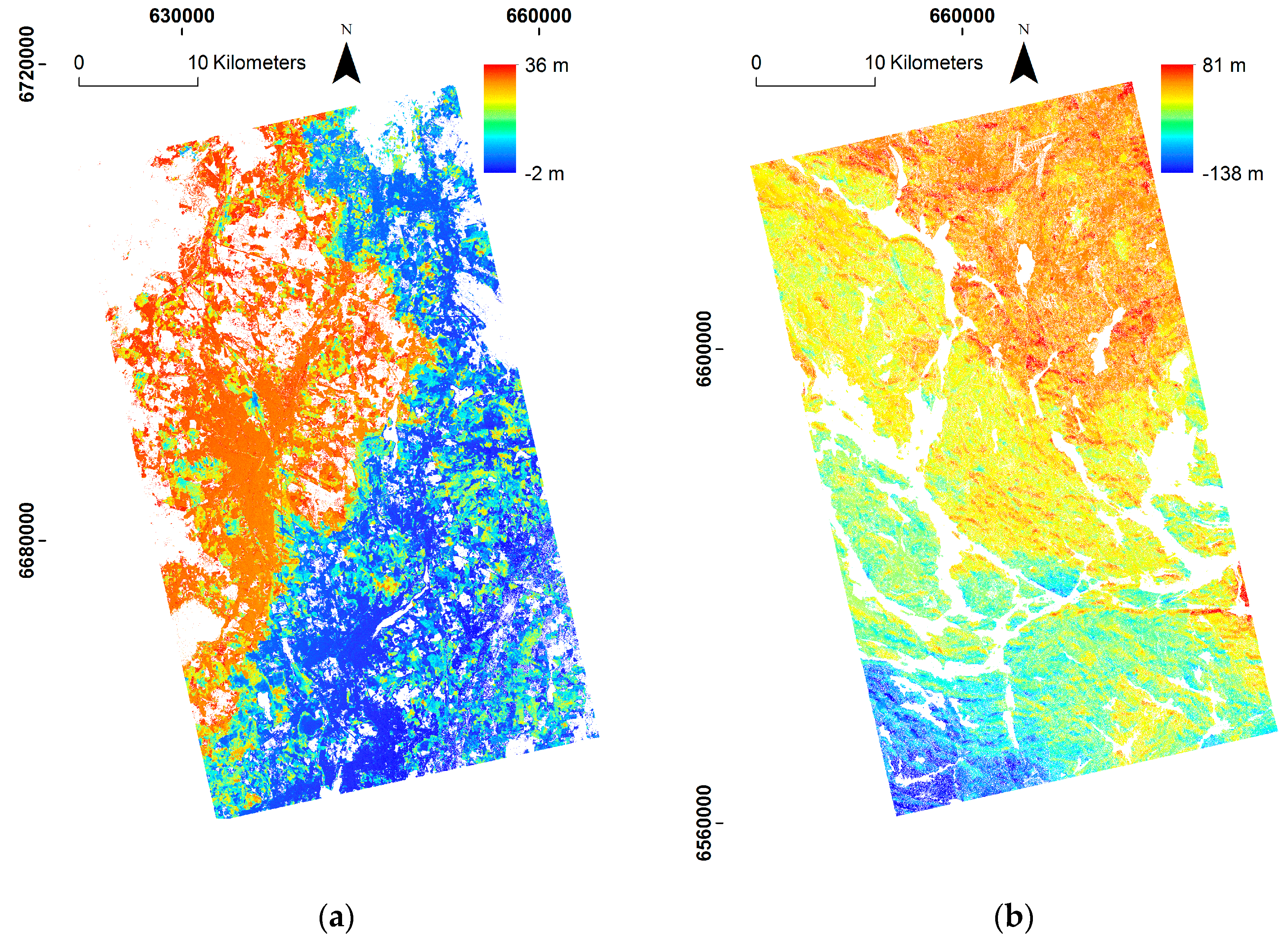
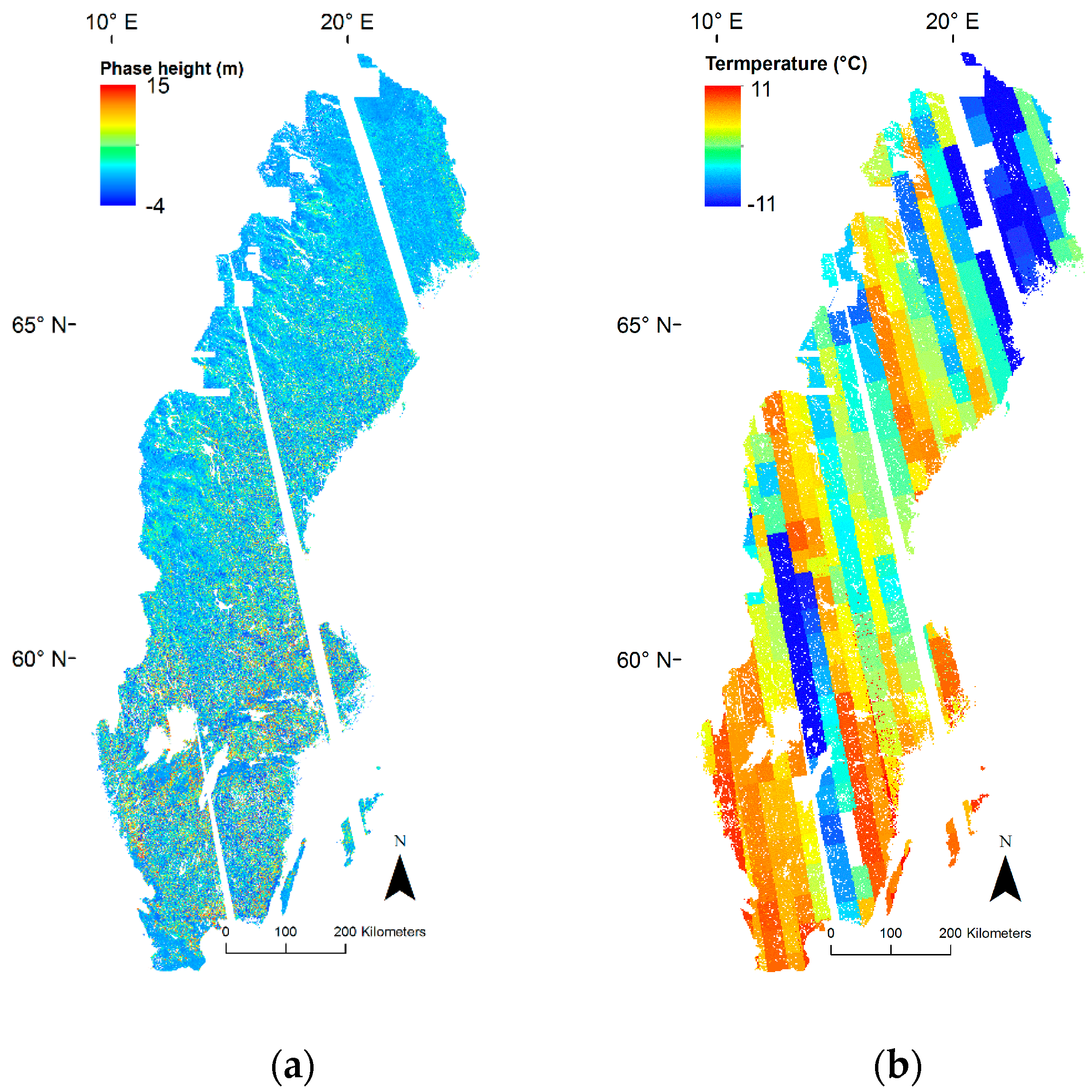
2.4. Special Processing Cases
2.4.1. Scenes with Too Low HOA for Forest Mapping
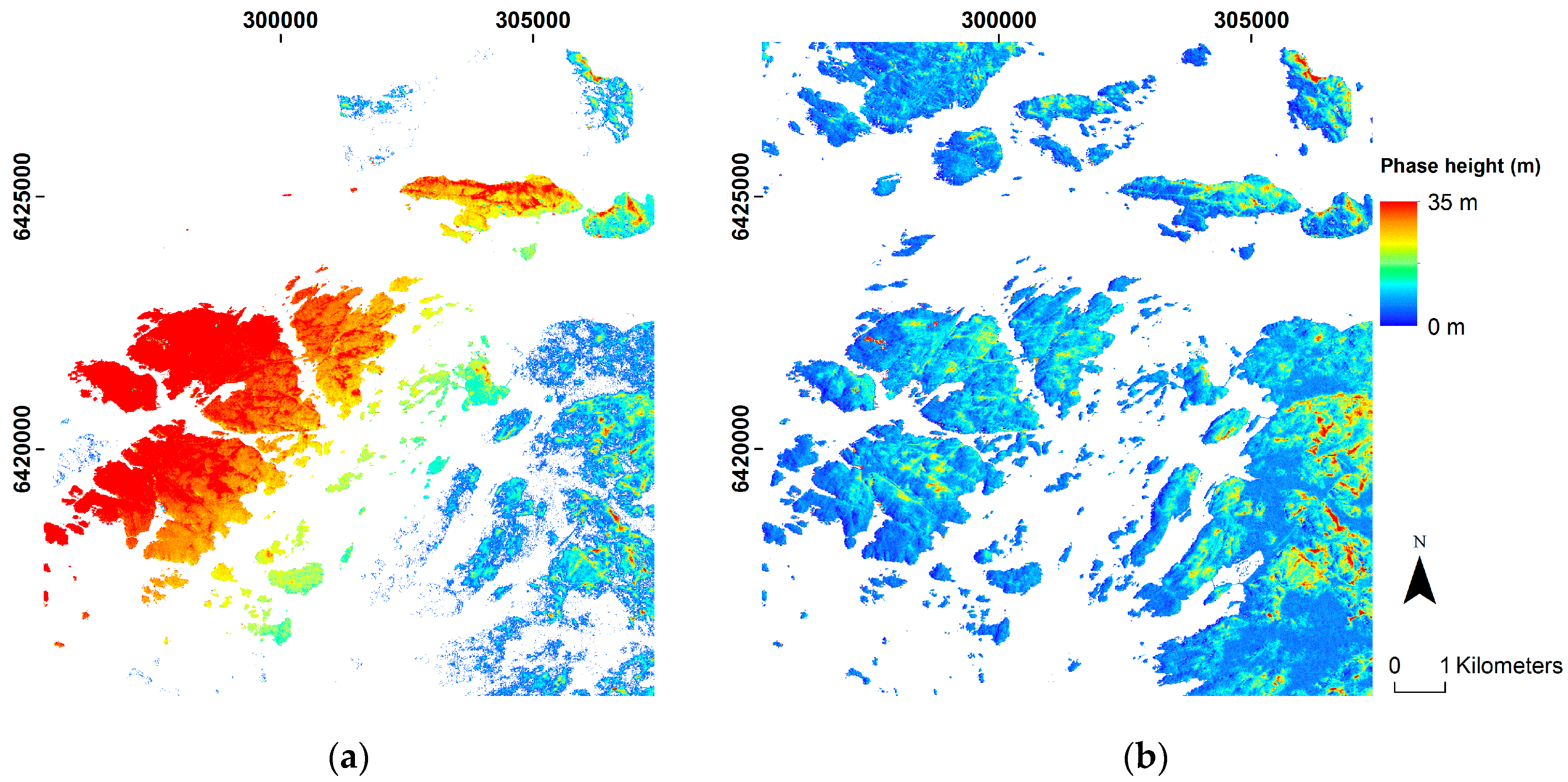
2.4.2. Scenes with Phase Trends
2.4.3. Scenes Acquired in Frozen Conditions
2.4.4. Scenes with Frozen Water Bodies
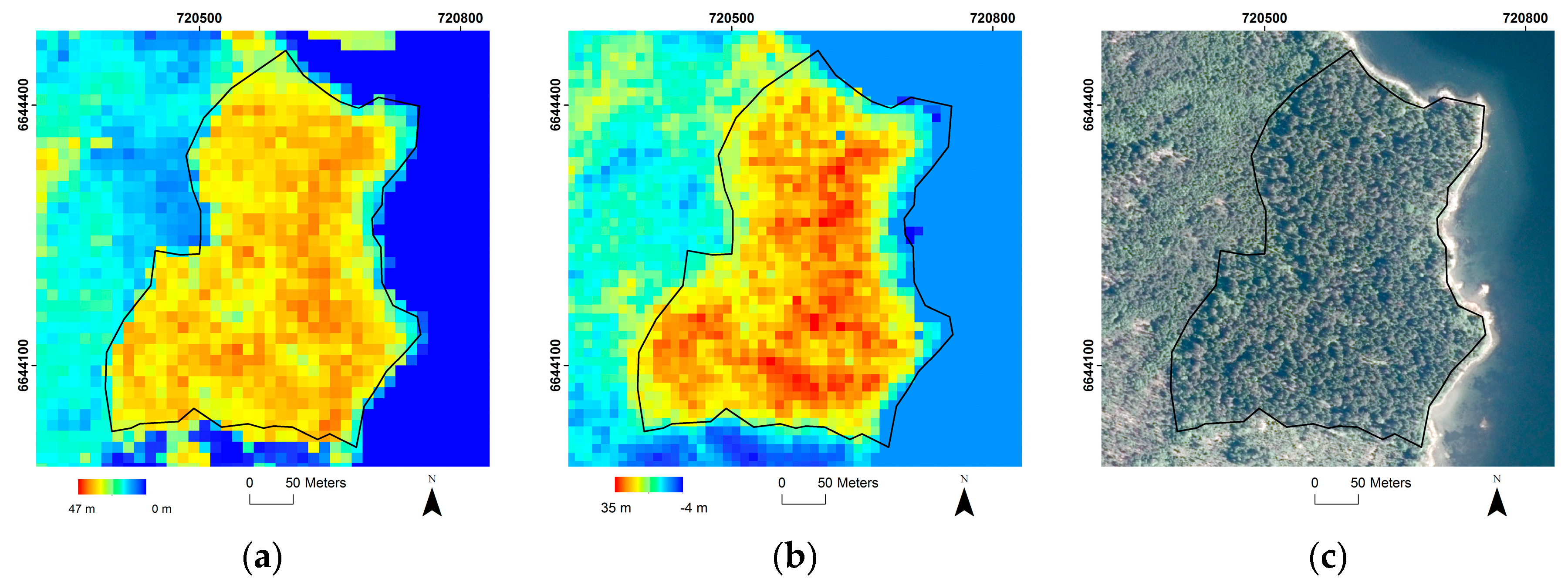
2.4.5. Scenes in the Archipelago
2.5. Data Extraction
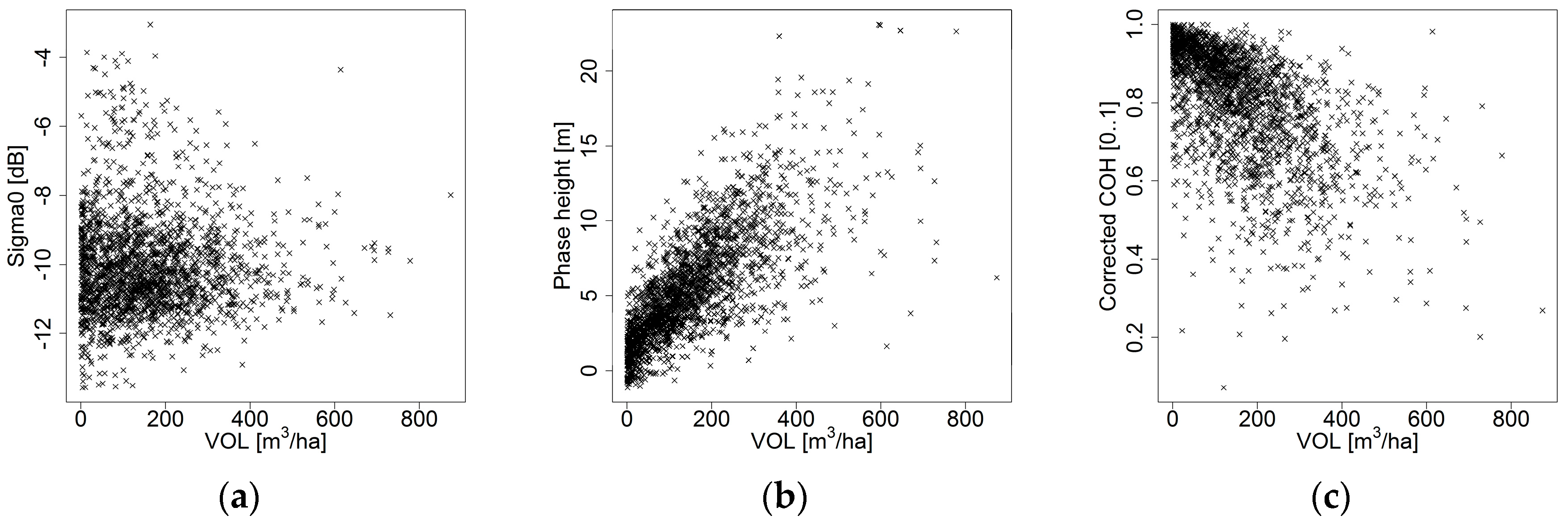
2.6. Relation between Observables and AGB and VOL
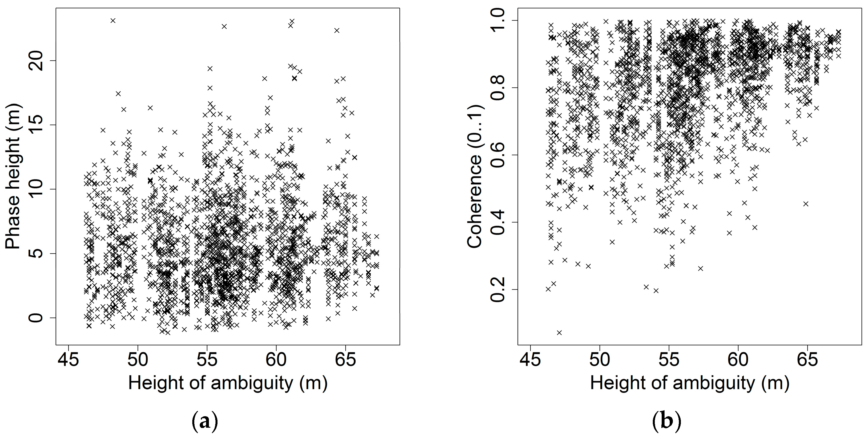
2.6.1. Observables’ Dependence on HOA
2.6.2. Empirical Modelling
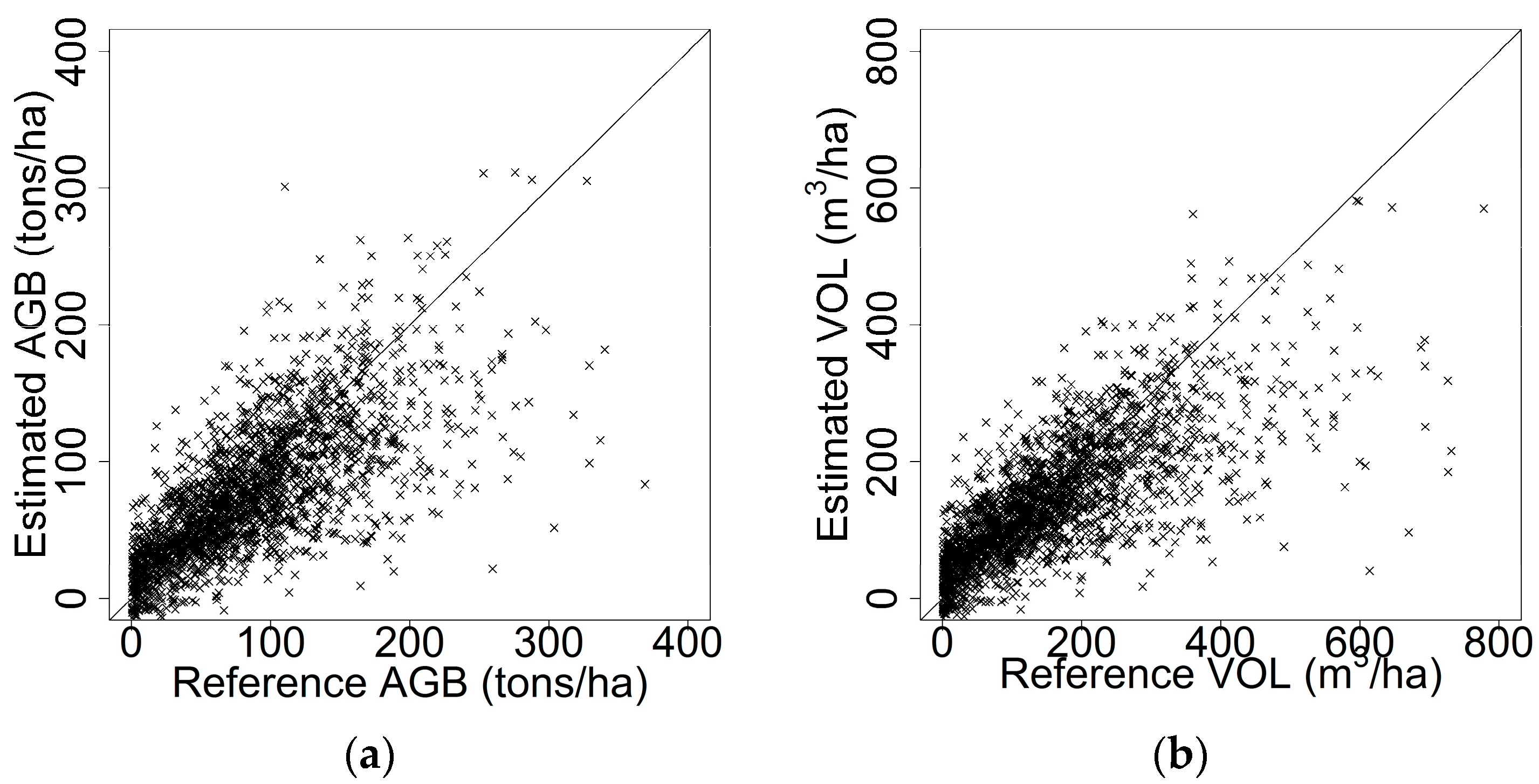
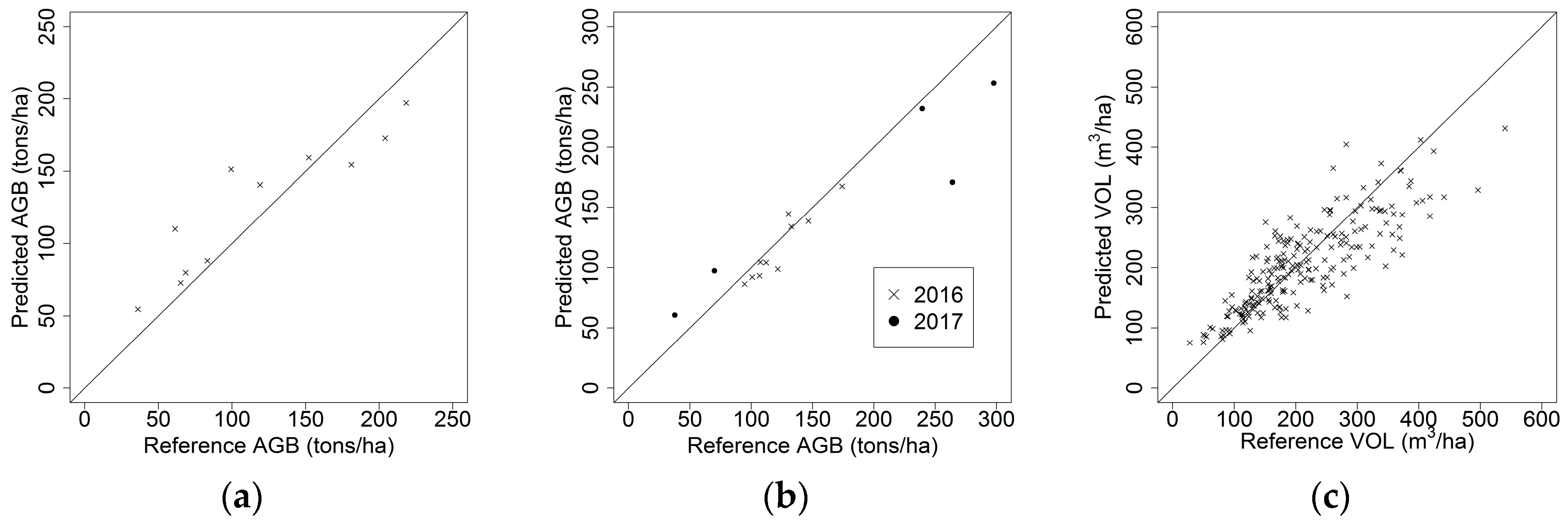
2.6.3. Assessment
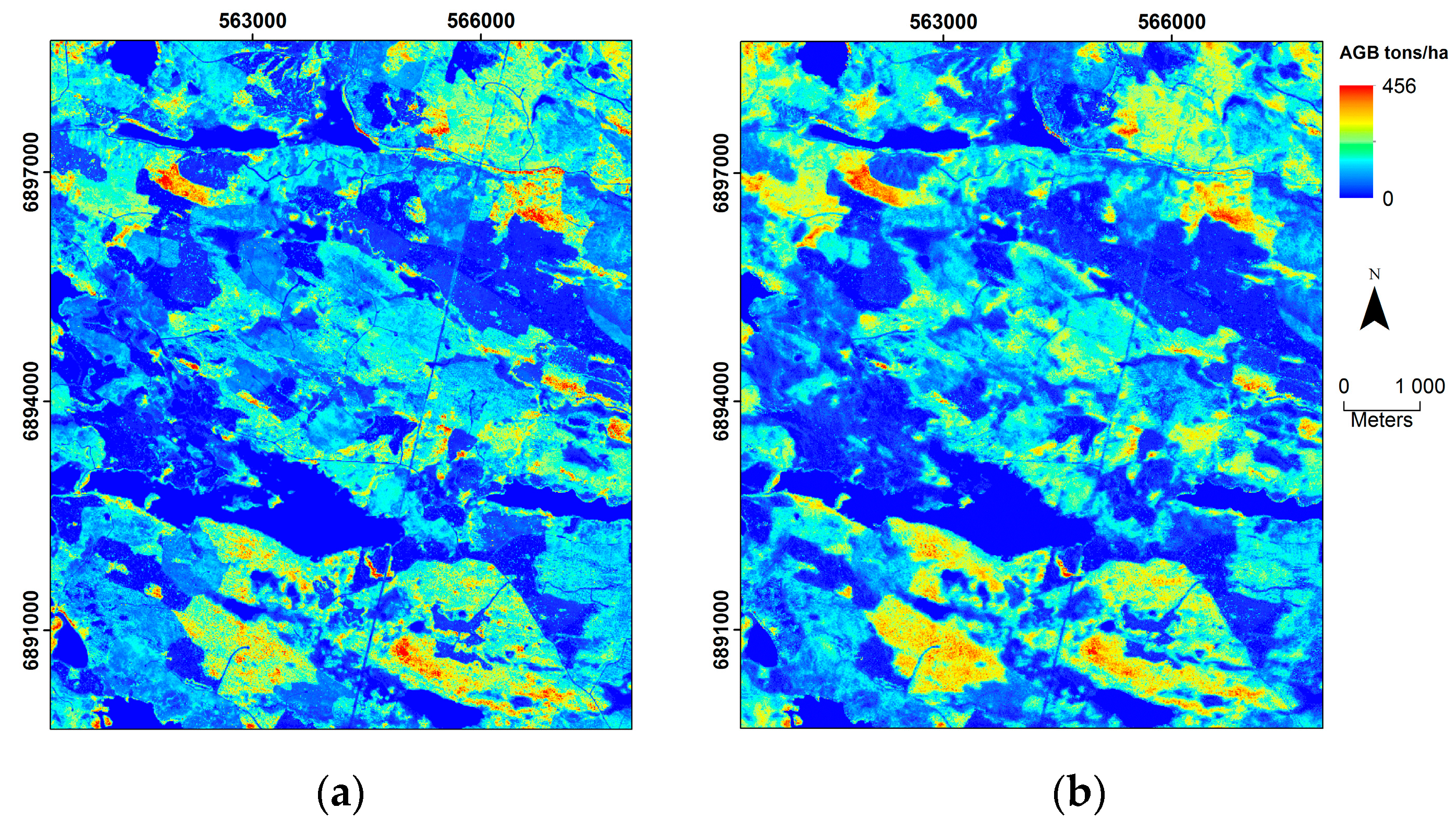
3. Results
4. Discussion
5. Conclusions
Acknowledgments
Author Contributions
Conflicts of Interest
References
- Næsset, E.; Gobakken, T.; Holmgren, J.; Hyyppä, H.; Hyyppä, J.; Maltamo, M.; Nilsson, M.; Olsson, H.; Persson, Å.; Söderman, U. Laser scanning of forest resources: The nordic experience. Scand. J. For. Res. 2004, 19, 482–499. [Google Scholar] [CrossRef]
- Hyyppä, J.; Hyyppä, H.; Inkinen, M.; Engdahl, M.; Linko, S.; Zhu, Y.-H. Accuracy comparison of various remote sensing data sources in the retrieval of forest stand attributes. For. Ecol. Manag. 2000, 128, 109–120. [Google Scholar] [CrossRef]
- Nilsson, M.; Nordkvist, K.; Jonzén, J.; Lindgren, N.; Axensten, P.; Wallerman, J.; Egberth, M.; Larsson, S.; Nilsson, L.; Eriksson, J.; et al. A nationwide forest attribute map of Sweden derived using airborne laser scanning data and field data from the national forest inventory. Remote Sens. Environ. 2017, 194, 447–454. [Google Scholar] [CrossRef]
- Häme, T.; Salli, A.; Lahti, K. Estimation of Carbon Storage in Boreal Forests Using Remote Sensing Data; Academy of Finland: Helsinki, Finland, 1992. [Google Scholar]
- Lei, Y.; Siqueira, P. An automatic mosaicking algorithm for the generation of a large-scale forest height map using spaceborne repeat-pass InSAR correlation magnitude. Remote Sens. 2015, 7, 5639–5659. [Google Scholar] [CrossRef]
- Gruber, A.; Wessel, B.; Martone, M.; Roth, A. The TanDEM-X DEM Mosaicking: Fusion of Multiple Acquisitions Using InSAR Quality Parameters. IEEE J. Sel. Top. Appl. Earth Obs. Remote Sens. 2016, 9, 1047–1057. [Google Scholar] [CrossRef]
- Reese, H.; Nilsson, M.; Sandström, P.; Olsson, H. Applications using estimates of forest parameters derived from satellite and forest inventory data. Comput. Electron. Agric. 2002, 37, 37–55. [Google Scholar] [CrossRef]
- Tomppo, E.; Olsson, H.; Ståhl, G.; Nilsson, M.; Hagner, O.; Katila, M. Combining national forest inventory field plots and remote sensing data for forest databases. Remote Sens. Environ. 2008, 112, 1982–1999. [Google Scholar] [CrossRef]
- Santoro, M.; Beaudoin, A.; Beer, C.; Cartus, O.; Fransson, J.E.S.; Hall, R.J.; Pathe, C.; Schmullius, C.; Schepaschenko, D.; Shvidenko, A.; et al. Forest growing stock volume of the northern hemisphere: Spatially explicit estimates for 2010 derived from Envisat ASAR. Remote Sens. Environ. 2015, 168, 316–334. [Google Scholar] [CrossRef]
- Santoro, M.; Cartus, O.; Fransson, J.E.S.; Shvidenko, A.; McCallum, I.; Hall, R.J.; Beaudoin, A.; Beer, C.; Schmullius, C. Estimates of forest growing stock volume for sweden, central siberia, and québec using envisat advanced synthetic aperture radar backscatter data. Remote Sens. 2013, 5, 4503–4532. [Google Scholar] [CrossRef]
- Santoro, M.; Beer, C.; Cartus, O.; Schmullius, C.C.; Shvidenko, A.; McCallum, I.; Wegmüller, U.; Wiesmann, A. The BIOMASAR algorithm: An approach for retrieval of forest growing stock volume using stacks of multi-temporal SAR data. In Proceedings of the ESA Living Planet Symposium, Bergen, Norway, 28 June–2 July 2010. [Google Scholar]
- Dobson, M.; Ulaby, F. Dependence of radar backscatter on coniferous forest biomass. IEEE Trans. Geosci. Remote Sens. 1992, 30, 412–415. [Google Scholar] [CrossRef]
- Rignot, E.; Way, J.; Williams, C.; Viereck, L. Radar estimates of aboveground biomass in boreal forests of interior Alaska. IEEE Trans. Geosci. Remote Sens. 1994, 32, 1117–1124. [Google Scholar] [CrossRef]
- Rizzoli, P.; Bräutigam, B.; Kraus, T.; Martone, M.; Krieger, G. Relative height error analysis of TanDEM-X elevation data. ISPRS J. Photogramm. Remote Sens. 2012, 73, 30–38. [Google Scholar] [CrossRef]
- Rossi, C.; Rodriguez Gonzalez, F.; Fritz, T.; Yague-Martinez, N.; Eineder, M. TanDEM-X calibrated Raw DEM generation. ISPRS J. Photogramm. Remote Sens. 2012, 73, 12–20. [Google Scholar] [CrossRef]
- Persson, H.J.; Fransson, J.E.S. Comparison between TanDEM-X and ALS based estimation of above ground biomass and tree height in boreal forests. Scand. J. For. Res. 2017, 32, 306–319. [Google Scholar] [CrossRef]
- Soja, M.J.; Persson, H.J.; Ulander, L.M.H. Estimation of forest height and canopy density from a single InSAR correlation coefficient. IEEE Geosci. Remote Sens. Lett. 2015, 12, 646–650. [Google Scholar] [CrossRef]
- Treuhaft, R.; Gonçalves, F.; dos Santos, J.R.; Keller, M.; Palace, M.; Madsen, S.N.; Sullivan, F.; Graça, P.M. Tropical-Forest Biomass Estimation at X-Band From the Spaceborne TanDEM-X Interferometer. IEEE Geosci. Remote Sens. Lett. 2015, 12, 239–243. [Google Scholar] [CrossRef]
- Kugler, F.; Schulze, D.; Hajnsek, I.; Pretzsch, H.; Papathanassiou, K.P. TanDEM-X Pol-InSAR Performance for Forest Height Estimation. IEEE Trans. Geosci. Remote Sens. 2014, 52, 6404–6422. [Google Scholar] [CrossRef]
- Abdullahi, S.; Kugler, F.; Pretzsch, H. Prediction of stem volume in complex temperate forest stands using TanDEM-X SAR data. Remote Sens. Environ. 2016, 174, 197–211. [Google Scholar] [CrossRef]
- Solberg, S.; Astrup, R.; Breidenbach, J.; Nilsen, B.; Weydahl, D. Monitoring spruce volume and biomass with InSAR data from TanDEM-X. Remote Sens. Environ. 2013, 139, 60–67. [Google Scholar] [CrossRef]
- Karila, K.; Vastaranta, M.; Karjalainen, M.; Kaasalainen, S. Tandem-X interferometry in the prediction of forest inventory attributes in managed boreal forests. Remote Sens. Environ. 2015, 159, 259–268. [Google Scholar] [CrossRef]
- Olesk, A.; Praks, J.; Antropov, O.; Zalite, K.; Arumäe, T.; Voormansik, K. Interferometric SAR Coherence Models for Characterization of Hemiboreal Forests Using TanDEM-X Data. Remote Sens. 2016, 8, 700. [Google Scholar] [CrossRef]
- Askne, J.I.H.; Soja, M.J.; Ulander, L.M.H. Biomass estimation in a boreal forest from TanDEM-X data, lidar DTM, and the interferometric water cloud model. Remote Sens. Environ. 2017, 196, 265–278. [Google Scholar] [CrossRef]
- Soja, M.J.; Askne, J.I.H.; Fellow, L.; Ulander, L.M.H. Estimation of Boreal Forest Properties from TanDEM-X Data using Inversion of the Interferometric Water Cloud Model. IEEE Geosci. Remote Sens. Lett. 2017, 14, 997–1001. [Google Scholar] [CrossRef]
- Fridman, J.; Holm, S.; Nilsson, M.; Nilsson, P. Adapting National Forest Inventories to changing requirements—The case of the Swedish National Forest Inventory at the turn of the 20th century. Silva Fenn. 2014, 48, 1–29. [Google Scholar] [CrossRef]
- Swedish National Forest Inventory. Skogsdata 2013; Aktuella uppgifter om de svenska skogarna från Riksskogstaxeringen; Institutionen för skoglig resurshushållning, Sveriges Lantbruksuniversitet: Umeå, Sweden, 2013. [Google Scholar]
- Ranneby, B.; Cruse, T.; Hägglund, B.; Jonasson, H.; Swärd, J. Designing a New National Forest Survey for Sweden; Swedish University of Agricultural Sciences: Uppsala, Sweden, 1987. [Google Scholar]
- Brandel, G. Volymfunktioner för Enskilda Träd: Tall, Gran Och BjöRk = Volume Functions for Individual Trees: Scots Pine (Pinus Sylvestris), Norway Spruce (Picea Abies) and Birch (Betula Pendula & Betula Pubescens); Sveriges lantbruksuniversitet, Institutionen för skogsproduktion: Garpenberg, Sweden, 1990. [Google Scholar]
- Marklund, L.G. Biomassafunktioner för Tall, Gran Och Björk i Sverige; Swedish National Forest Inventory: Umeå, Sweden, 1988. [Google Scholar]
- Lindgren, O. Validation of stand-wise forest data based on ALS. In Proceedings of the Silvilaser 2012, Vancouver, BC, Canada, 16–19 September 2012; pp. 1–8. [Google Scholar]
- Rönnberg, A. Kartografisk Information ur Laserdata; Lantmäteriet: Gävle, Sweden, 2011; Volume 1. [Google Scholar]
- Bergström, H.; Melin, H.; Nicolausson, A. Höjddata—En Förutsättning för Klimatanpassning; Swedish National Land Survey: Gävle, Sweden, 2009. [Google Scholar]
- Solberg, S.; Weydahl, D.J.; Astrup, R. Temporal stability of X-band single-pass InSAR heights in a spruce forest: Effects of acquisition properties and season. IEEE Trans. Geosci. Remote Sens. 2015, 53, 1607–1614. [Google Scholar] [CrossRef]
- Duque, S.; Balss, U.; Rossi, C.; Fritz, T.; Balzer, W. TanDEM-X Payload Ground Segment: CoSSC Generation and Interferometric Considerations; German Aerospace Center: Oberpfaffenhofen, Germany, 2012. [Google Scholar]
- Wegmüller, U. Automated terrain corrected SAR geocoding. IEEE Int. Geosci. Remote Sens. Symp. 1999, 3, 1712–1714. [Google Scholar]
- Small, D. Flattening gamma: Radiometric terrain correction for SAR imagery. IEEE Trans. Geosci. Remote Sens. 2011, 49, 3081–3093. [Google Scholar] [CrossRef]
- Frey, O.; Santoro, M.; Werner, C.L.; Wegmuller, U. DEM-Based SAR Pixel-Area Estimation for Enhanced Geocoding Refinement and Radiometric Normalization. IEEE Geosci. Remote Sens. Lett. 2013, 10, 48–52. [Google Scholar] [CrossRef]
- Bamler, R.; Hartl, P. Synthetic aperture radar interferometry. Inverse Probl. 1998, 14, 55. [Google Scholar] [CrossRef]
- Hanssen, R.F. Radar Interferometry: Data Interpretation and Error Analysis, 2nd ed.; Springer: Dordrecht, The Netherlands, 2001. [Google Scholar]
- Hagberg, J.O.; Ulander, L.M.H.; Askne, J. Repeat-pass SAR interferometry over forested terrain. IEEE Trans. Geosci. Remote Sens. 1995, 33, 331–340. [Google Scholar] [CrossRef]
- Moreira, A.; Prats-Iraola, P.; Younis, M.; Krieger, G.; Hajnsek, I.; Papathanassiou, K. A Tutorial on Synthetic Aperture Radar. IEEE Geosci. Remote Sens. Mag. 2013, 1, 6–43. [Google Scholar] [CrossRef]
- Goldstein, R.M.; Werner, C.L. Radar interferogram filtering for geophysical applications. Geophys. Res. Lett. 1998, 25, 4035–4038. [Google Scholar] [CrossRef]
- Wegmüller, U.; Werner, C.L.; Strozzi, T.; Wiesmann, A. Phase Unwrapping with GAMMA ISP Technical Report, 13-May-2002; Gamma Remote Sensing: Bern, Switzerland, 2002. [Google Scholar]
- Bachmann, M.; Schwerdt, M.; Alfonzo, G.C.; Schrank, D. Phase pattern calibration for interferometric applications in spaceborne SAR systems. Int. J. Antennas Propag. 2013, 2013. [Google Scholar] [CrossRef]
- Chen, H.; Cloude, S.R.; Goodenough, D.G. Forest Canopy Height Estimation Using Tandem-X Coherence Data. IEEE J. Sel. Top. Appl. Earth Obs. Remote Sens. 2016, 9, 3177–3188. [Google Scholar] [CrossRef]
- Zebker, H.A.; Villasenor, J. Decorrelation in interferometric radar echoes. IEEE Trans. Geosci. Remote Sens. 1992, 30, 950–959. [Google Scholar] [CrossRef]
- Just, D.; Bamler, R. Phase statistics of interferograms with applications to synthetic aperture radar. Appl. Opt. 1994, 33, 4361–4368. [Google Scholar] [CrossRef] [PubMed]
- Gonzalez, J.H.; Bachmann, M.; Krieger, G.; Fiedler, H. Development of the TanDEM-X calibration concept: Analysis of systematic errors. IEEE Trans. Geosci. Remote Sens. 2010, 48, 716–726. [Google Scholar] [CrossRef]
- Solberg, S.; Lohne, T.-P.; Karyanto, O. Temporal stability of InSAR height in a tropical rainforest. Remote Sens. Lett. 2015, 6, 209–217. [Google Scholar] [CrossRef]
- Cartus, O.; Santoro, M.; Schmullius, C.; Li, Z. Large area forest stem volume mapping in the boreal zone using synergy of ERS-1/2 tandem coherence and MODIS vegetation continuous fields. Remote Sens. Environ. 2011, 115, 931–943. [Google Scholar] [CrossRef]
- Ruggero, B.; Ventura, L. An Introduction to Robust Estimation with R Functions. 2005. Available online: https://www.google.ch/url?sa=t&rct=j&q=&esrc=s&source=web&cd=1&ved=0ahUKEwiQkN71yerXAhVJPFAKHSp-AncQFggsMAA&url=https%3A%2F%2Fwww.researchgate.net%2Ffile.PostFileLoader.html%3Fid%3D569bc60d6307d906458b45c8%26assetKey%3DAS%253A318926276235267%25401453049357465&usg=AOvVaw0N54DKxgwPk_zmo58QC3Uq (accessed on 12 October 2017).
- Susanti, Y.; Pratiwi, H.; Sulistijowati, H.S.; Liana, T. M estimation, S estimation, and Mm Estimation in Robust Regression. Int. J. Pure Appl. Math. 2014, 91, 349–360. [Google Scholar] [CrossRef]
- Hyndman, R.J.; Koehler, A.B. Another look at measures of forecast accuracy. Int. J. Forecast. 2006, 22, 679–688. [Google Scholar] [CrossRef]
- Soja, M.J.; Ulander, L.M.H. Digital Canopy Model Estimation from TanDEM-X Interferometry Using High-resolution Lidar DEM. In Proceedings of the IEEE International Geoscience and Remote Sensing Symposium, Melbourne, Australia, 21–26 July 2013; pp. 165–168. [Google Scholar]
- Imhoff, M.L. Radar backscatter and biomass saturation: Ramifications for global biomass inventory. IEEE Trans. Geosci. Remote Sens. 1995, 33, 511–518. [Google Scholar] [CrossRef]
- Le Toan, T.; Beaudoin, A.; Riom, J.; Guyon, D. Relating forest biomass to SAR data. IEEE Trans. Geosci. Remote Sens. 1992, 30, 403–411. [Google Scholar] [CrossRef]
- Solberg, S.; Astrup, R.; Gobakken, T.; Næsset, E.; Weydahl, D.J. Estimating spruce and pine biomass with interferometric X-band SAR. Remote Sens. Environ. 2010, 114, 2353–2360. [Google Scholar] [CrossRef]
- Soja, M.J.; Persson, H.J.; Ulander, L.M.H. Estimation of boreal forest biomass from two-level model inversion of interferometric TanDEM-X data. In Proceedings of the IEEE International Geoscience and Remote Sensing Symposium, Quebec City, QC, Canada, 13–18 July 2014; pp. 3398–3401. [Google Scholar]
- Praks, J.; Antropov, O.; Hallikainen, M.T. LIDAR-Aided SAR interferometry studies in boreal forest: Scattering phase center and extinction coefficient at X- and L-band. IEEE Trans. Geosci. Remote Sens. 2012, 50, 3831–3843. [Google Scholar] [CrossRef]
- Soja, M.J.; Persson, H.J.; Ulander, L.M.H. Estimation of forest biomass from two-level model inversion of single-pass InSAR data. IEEE Trans. Geosci. Remote Sens. 2015, 53, 5083–5099. [Google Scholar] [CrossRef]
- Askne, J.I.H.; Fransson, J.E.S.; Santoro, M.; Soja, M.J.; Ulander, L.M.H. Model-based biomass estimation of a hemi-boreal forest from multitemporal TanDEM-X acquisitions. Remote Sens. 2013, 5, 5574–5597. [Google Scholar] [CrossRef]
- Caicoya, A.T.; Kugler, F.; Hajnsek, I.; Papathanassiou, K.P. Large-Scale Biomass Classification in Boreal Forests With TanDEM-X Data. IEEE Trans. Geosci. Remote Sens. 2016, 54, 5935–5951. [Google Scholar] [CrossRef]


| Dataset | Purpose | Forest Attribute | Mean | Min | Max | SD | Unit | n |
|---|---|---|---|---|---|---|---|---|
| Swedish NFI | Training | AGB | 86 | 0 | 369 | 59.3 | tons/ha | 2288 |
| Swedish NFI | Training | VOL | 162 | 0 | 874 | 129 | m3/ha | 2288 |
| Northern Sweden | Evaluation | AGB | 117 | 36 | 218 | 63.0 | tons/ha | 11 |
| Northern Sweden | Evaluation | VOL | 219 | 56 | 395 | 120 | m3/ha | 11 |
| Central Sweden | Evaluation | VOL | 203 | 0 | 577 | 102 | m3/ha | 354 |
| Southern Sweden | Evaluation | AGB | 152 | 38 | 339 | 86.0 | tons/ha | 18 |
| Southern Sweden | Evaluation | VOL | 286 | 49 | 657 | 170 | m3/ha | 18 |
| Forest Attribute | SE | Bias | RMSEcv | RMSEcv% | Unit | n |
|---|---|---|---|---|---|---|
| AGB | 31.7 | 8.82 | 43.1 | 50.5 | tons/ha | 2,108 |
| VOL | 58.6 | 15.6 | 87.1 | 54.9 | m3/ha | 2,108 |
| Test Site | Forest Attribute | RMSE | Bias | Unit | RMSE% | n |
|---|---|---|---|---|---|---|
| Northern Sweden | AGB | 27.4 | −6.17 | tons/ha | 23.4 | 11 |
| Northern Sweden | VOL | 55.3 | −11.1 | m3/ha | 25.2 | 11 |
| Central Sweden | VOL | 52.4 | 4.90 | m3/ha | 25.0 | 222 |
| Southern Sweden | AGB | 29.7 | 10.5 | tons/ha | 20.8 | 15 |
| Southern Sweden | VOL | 65.1 | 23.1 | m3/ha | 24.1 | 15 |
© 2017 by the authors. Licensee MDPI, Basel, Switzerland. This article is an open access article distributed under the terms and conditions of the Creative Commons Attribution (CC BY) license (http://creativecommons.org/licenses/by/4.0/).
Share and Cite
Persson, H.J.; Olsson, H.; Soja, M.J.; Ulander, L.M.H.; Fransson, J.E.S. Experiences from Large-Scale Forest Mapping of Sweden Using TanDEM-X Data. Remote Sens. 2017, 9, 1253. https://doi.org/10.3390/rs9121253
Persson HJ, Olsson H, Soja MJ, Ulander LMH, Fransson JES. Experiences from Large-Scale Forest Mapping of Sweden Using TanDEM-X Data. Remote Sensing. 2017; 9(12):1253. https://doi.org/10.3390/rs9121253
Chicago/Turabian StylePersson, Henrik J., Håkan Olsson, Maciej J. Soja, Lars M.H. Ulander, and Johan E.S. Fransson. 2017. "Experiences from Large-Scale Forest Mapping of Sweden Using TanDEM-X Data" Remote Sensing 9, no. 12: 1253. https://doi.org/10.3390/rs9121253
APA StylePersson, H. J., Olsson, H., Soja, M. J., Ulander, L. M. H., & Fransson, J. E. S. (2017). Experiences from Large-Scale Forest Mapping of Sweden Using TanDEM-X Data. Remote Sensing, 9(12), 1253. https://doi.org/10.3390/rs9121253