SCaMF–RM: A Fused High-Resolution Land Cover Product of the Rocky Mountains


Abstract
1. Introduction
2. Materials and Methods
2.1. Region of Interest
2.2. Land Cover Datasets
2.3. SCaMF Methodology and Proposed Modifications
2.4. Large-Scale Considerations
2.4.1. Computational Implementation
2.4.2. Simplifications in the Characterization of the Spatial and Temporal Dependences
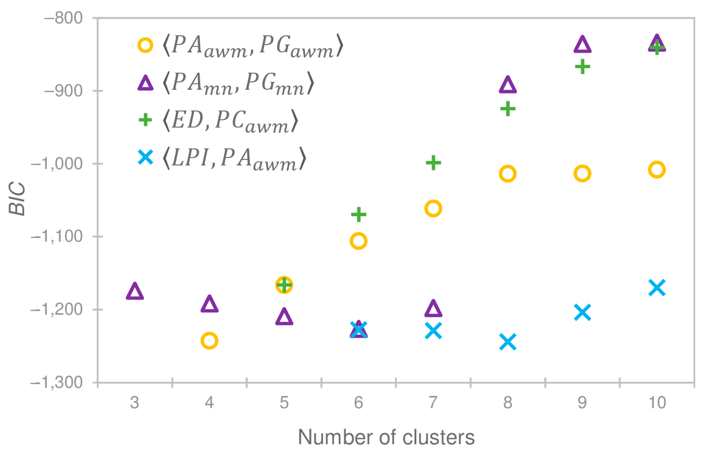
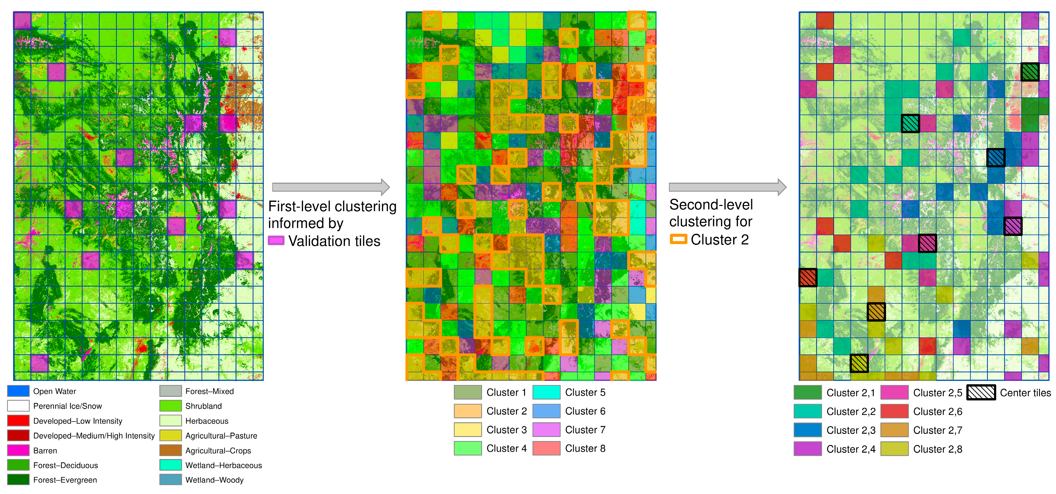
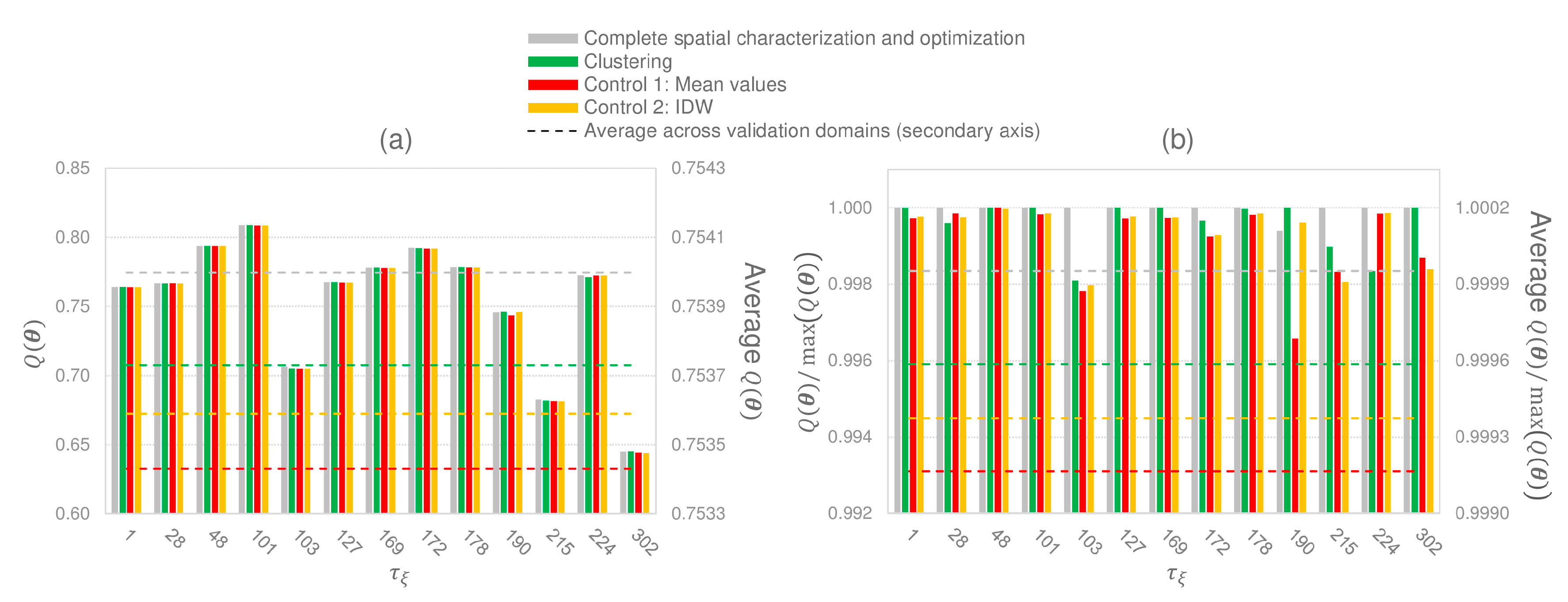
2.4.3. Domain Clustering
- Largest Patch Index (): Area of the largest patch divided by the area of the domain tile.
- Edge Density (): Ratio between the sum of the length of all patch edges and the domain tile area.
- Patch Area (): Area covered by a specific patch.
- Patch Gyrate (): Mean distance among all cells in a specific patch.
- Patch Shape (): Ratio between the perimeter of a specific patch and .
- Patch Contiguity (): Average contiguity value among all cells in a specific patch. A cell has a contiguity value of 1 if its class is the same as the class of all its adjacent cells and 0 otherwise.
3. Results
4. Discussion
5. Conclusions
Acknowledgments
Author Contributions
Conflicts of Interest
References
- Boucher, A.; Seto, K.C.; Journel, A.G. A novel method for mapping land cover changes: Incorporating time and space with geostatistics. IEEE Trans. Geosci. Remote Sens. 2006, 44, 3427–3435. [Google Scholar] [CrossRef]
- Foody, G.M. Status of land cover classification accuracy assessment. Remote Sens. Environ. 2002, 80, 185–201. [Google Scholar] [CrossRef] [Scilit]
- Gao, Z.; Liu, J.; Cao, M.; Li, K.; Tao, B. Impacts of land-use and climate changes on ecosystem productivity and carbon cycle in the cropping-grazing transitional zone in China. Sci. China Ser. Earth Sci. 2005, 48, 1479–1491. [Google Scholar] [CrossRef] [Scilit]
- Rathjens, H.; Dörnhöfer, K.; Oppelt, N. IRSeL—An approach to enhance continuity and accuracy of remotely sensed land cover data. Int. J. Appl. Earth Obs. Geoinf. 2014, 31, 1–12. [Google Scholar] [CrossRef] [Scilit]
- Eva, H.; Lambin, E.F. Fires and land-cover change in the tropics: A remote sensing analysis at the landscape scale. J. Biogeogr. 2000, 27, 765–776. [Google Scholar] [CrossRef] [Scilit]
- Friedl, M.A.; Sulla-Menashe, D.; Tan, B.; Schneider, A.; Ramankutty, N.; Sibley, A.; Huang, X. MODIS Collection 5 global land cover: Algorithm refinements and characterization of new datasets. Remote Sens. Environ. 2010, 114, 168–182. [Google Scholar] [CrossRef] [Scilit]
- Fry, J.; Xian, G.; Jin, S.; Dewitz, J.; Homer, C.; Yang, L.; Barnes, C.; Herold, N.; Wickham, J. Completion of the 2006 National Land Cover Database for the conterminous United States. Photogramm. Eng. Remote Sens. 2011, 77, 858–864. [Google Scholar]
- Jin, S.; Yang, L.; Danielson, P.; Homer, C.; Fry, J.; Xian, G. A comprehensive change detection method for updating the National Land Cover Database to circa 2011. Remote Sens. Environ. 2013, 132, 159–175. [Google Scholar] [CrossRef] [Scilit]
- Liang, L.; Chen, Y.; Hawbaker, T.J.; Zhu, Z.; Gong, P. Mapping mountain pine beetle mortality through growth trend analysis of time-series Landsat data. Remote Sens. 2014, 6, 5696–5716. [Google Scholar] [CrossRef] [Scilit]
- Meddens, A.J.H.; Hicke, J.A.; Ferguson, C.A. Spatiotemporal patterns of observed bark beetle-caused tree mortality in British Columbia and the western United States. Ecol. Appl. 2012, 22, 1876–1891. [Google Scholar] [CrossRef] [Scilit] [PubMed]
- Jung, M.; Henkel, K.; Herold, M.; Churkina, G. Exploiting synergies of global land cover products for carbon cycle modeling. Remote Sens. Environ. 2006, 101, 534–553. [Google Scholar] [CrossRef] [Scilit]
- Turner, M.G. Landscape ecology: What is the state of the science? Annu. Rev. Ecol. Evol. Syst. 2005, 36, 319–344. [Google Scholar] [CrossRef] [Scilit]
- Calvert, K.; Luciani, P.; Mabee, W. Thematic land-cover map assimilation and synthesis: The case of locating potential bioenergy feedstock in eastern Ontario, Canada. Int. J. Geogr. Inf. Sci. 2014, 28, 274–295. [Google Scholar] [CrossRef] [Scilit]
- Homer, C.; Dewitz, J.A.; Yang, L.; Jin, S.; Danielson, P.; Xian, P.; Coulston, J.; Herold, N.D.; Wickham, J.D.; Megown, K. Completion of the 2011 National Land Cover Database for the conterminous United States—Representing a decade of land cover change information. Photogramm. Eng. Remote Sens. 2015, 81, 345–354. [Google Scholar]
- Petit, C.C.; Lambin, E.F. Integration of multi-source remote sensing data for land cover change detection. Int. J. Geogr. Inf. Sci. 2001, 15, 785–803. [Google Scholar] [CrossRef] [Scilit]
- Foody, G.M. Approaches for the production and evaluation of fuzzy land cover classifications from remotely-sensed data. Int. J. Remote Sens. 1996, 17, 1317–1340. [Google Scholar] [CrossRef] [Scilit]
- Latifovic, R.; Zhu, Z.-L.; Cihlar, J.; Giri, C.; Olthof, I. Land cover mapping of North and Central America—Global Land Cover 2000. Remote Sens. Environ. 2004, 89, 116–127. [Google Scholar] [CrossRef] [Scilit]
- Vogelmann, J.E.; Howard, S.M.; Yang, L.; Larson, C.R.; Wylie, B.K.; Van Driel, J.N. Completion of the 1990’s National Land Cover Data Set for the conterminous United States. Photogramm. Eng. Remote Sens. 2001, 67, 650–662. [Google Scholar]
- Jin, C.; Zhu, J.; Steen-Adams, M.M.; Sain, S.R.; Gangnon, R.E. Spatial multinomial regression models for nominal categorical data: A study of land cover in Northern Wisconsin, USA. Environmetrics 2013, 24, 98–108. [Google Scholar] [CrossRef] [Scilit]
- Burkhard, B.; Kroll, F.; Nedkov, S.; Müller, F. Mapping ecosystem service supply, demand and budgets. Ecol. Indic. 2012, 21, 17–29. [Google Scholar] [CrossRef] [Scilit]
- Goldstein, N.C.; Candau, J.T.; Clarke, K.C. Approaches to simulating the “March of Bricks and Mortar”. Comput. Environ. Urban Syst. 2004, 28, 125–147. [Google Scholar] [CrossRef] [Scilit]
- Pai, N.; Saraswat, D. SWAT2009-LUC: A tool to activate the land use change module in SWAT 2009. Trans. ASABE 2011, 54, 1649–1658. [Google Scholar] [CrossRef] [Scilit]
- Wentz, E.A.; Peuquet, D.J.; Anderson, S. An ensemble approach to space–time interpolation. Int. J. Geogr. Inf. Sci. 2010, 24, 1309–1325. [Google Scholar] [CrossRef] [Scilit]
- Johnson, E.W.; Ross, J. USDA Forest Service Rocky Mountain Region Forest Health Aerial—Survey Accuracy Assessment 2005 Report; Technical Report R2–06–08; USDA Forest Service: Lakewood, CO, USA, 2006. [Google Scholar]
- Baron, J. Rocky Mountain Futures: An Ecological Perspective; Island Press: Washington DC, United States, 2002. [Google Scholar]
- Kerr, J.T.; Ostrovsky, M. From space to species: Ecological applications for remote sensing. Trends Ecol. Evol. 2003, 18, 299–305. [Google Scholar] [CrossRef] [Scilit]
- Lambin, E.F. Modelling and monitoring land-cover change processes in tropical regions. Prog. Phys. Geogr. 1997, 21, 375–393. [Google Scholar] [CrossRef] [Scilit]
- Townshend, J.; Justice, C.; Li, W.; Gurney, C.; McManus, J. Global land cover classification by remote sensing: Present capabilities and future possibilities. Remote Sens. Environ. 1991, 35, 243–255. [Google Scholar] [CrossRef] [Scilit]
- Welch, R. Spatial resolution requirements for urban studies. Int. J. Remote Sens. 1982, 3, 139–146. [Google Scholar] [CrossRef] [Scilit]
- Foody, G.M. Harshness in image classification accuracy assessment. Int. J. Remote Sens. 2008, 29, 3137–3158. [Google Scholar] [CrossRef] [Scilit]
- Wilkinson, G.G. Results and implications of a study of fifteen years of satellite image classification experiments. IEEE Trans. Geosci. Remote Sens. 2005, 43, 433–440. [Google Scholar] [CrossRef] [Scilit]
- Congalton, R.G.; Green, K. Assessing the Accuracy of Remotely Sensed Data: Principles and Practices; CRC Press: Boca Raton, FL, USA, 2002. [Google Scholar]
- Pontius, R.G.; Millones, M. Death to Kappa: Birth of quantity disagreement and allocation disagreement for accuracy assessment. Int. J. Remote Sens. 2011, 32, 4407–4429. [Google Scholar] [CrossRef] [Scilit]
- Trodd, N.M. Uncertainty in land cover mapping for modelling land cover change. In Proceedings of the 21st Annual Conference of the Remote Sensing Society (RSS95-Remote Sensing in Action), Nottingham, England, 11–14 September 1995. [Google Scholar]
- Meer, F.V. der Remote-sensing image analysis and geostatistics. Int. J. Remote Sens. 2012, 33, 5644–5676. [Google Scholar] [CrossRef] [Scilit]
- Rodríguez-Jeangros, N.; Hering, A.S.; Kaiser, T.; McCray, J. Fusing multiple existing space-time land cover products. Environmetrics 2017. [Google Scholar] [CrossRef] [Scilit]
- Allard, D.; D’Or, D.; Froidevaux, R. An efficient maximum entropy approach for categorical variable prediction. Eur. J. Soil Sci. 2011, 62, 381–393. [Google Scholar] [CrossRef] [Scilit]
- Berrett, C.; Calder, C.A. Bayesian spatial binary classification. Spat. Stat. 2016, 16, 72–102. [Google Scholar] [CrossRef] [Scilit]
- Cao, G.; Kyriakidis, P.; Goodchild, M. A geostatistical framework for categorical spatial data modeling. SIGSPATIAL Spec. 2011, 3, 4–9. [Google Scholar] [CrossRef] [Scilit]
- Carle, S.F.; Fogg, G.E. Transition probability-based indicator geostatistics. Math. Geol. 1996, 28, 453–476. [Google Scholar] [CrossRef] [Scilit]
- Li, W. Markov chain random fields for estimation of categorical variables. Math. Geol. 2007, 39, 321–335. [Google Scholar] [CrossRef] [Scilit]
- Li, W.; Zhang, C. Application of transiograms to Markov chain simulation and spatial uncertainty assessment of land-cover classes. GISci. Remote Sens. 2005, 42, 297–319. [Google Scholar] [CrossRef] [Scilit]
- Viviroli, D.; Dürr, H.H.; Messerli, B.; Meybeck, M.; Weingartner, R. Mountains of the world, water towers for humanity: Typology, mapping, and global significance. Water Resour. Res. 2007, 43, W07447. [Google Scholar] [CrossRef] [Scilit]
- Hauer, F.R.; Baron, J.S.; Campbell, D.H.; Fausch, K.D.; Hostetler, S.W.; Leavesley, G.H.; Leavitt, P.R.; Mcknight, D.M.; Stanford, J.A. Assessment of climate change and freshwater ecosystems of the Rocky Mountains, USA and Canada. Hydrol. Process. 1997, 11, 903–924. [Google Scholar] [CrossRef]
- Carey, E.V.; Sala, A.; Keane, R.; Callaway, R.M. Are old forests underestimated as global carbon sinks? Glob. Chang. Biol. 2001, 7, 339–344. [Google Scholar] [CrossRef] [Scilit]
- Hansen, E.M.; Amacher, M.C.; Van Miegroet, H.; Long, J.N.; Ryan, M.G. Carbon dynamics in central US rockies lodgepole pine type after mountain pine beetle outbreaks. For. Sci. 2015. [Google Scholar] [CrossRef] [Scilit]
- Mikkelson, K.M.; Bearup, L.A.; Maxwell, R.M.; Stednick, J.D.; McCray, J.E.; Sharp, J.O. Bark beetle infestation impacts on nutrient cycling, water quality and interdependent hydrological effects. Biogeochemistry 2013, 115, 1–21. [Google Scholar] [CrossRef] [Scilit]
- Hess, C.T.; Michel, J.; Horton, T.R.; Prichard, H.M.; Coniglio, W.A. The occurrence of radioactivity in public water supplies in the United States. Health Phys. 1985, 48, 553–586. [Google Scholar] [CrossRef] [Scilit] [PubMed]
- Jirak, I.L.; Cotton, W.R. Effect of air pollution on precipitation along the front range of the Rocky Mountains. J. Appl. Meteorol. Climatol. 2006, 45, 236–245. [Google Scholar] [CrossRef] [Scilit]
- Pec, G.J.; Karst, J.; Sywenky, A.N.; Cigan, P.W.; Erbilgin, N.; Simard, S.W.; Cahill, J.F. Rapid increases in forest understory diversity and productivity following a mountain pine beetle (dendroctonus ponderosae) outbreak in pine forests. PLOS ONE 2015, 10, e0124691. [Google Scholar] [CrossRef] [Scilit] [PubMed]
- Veblen, T.T.; Lorenz, D.C. Anthropogenic disturbance and recovery patterns in montane forests, Colorado front range. Phys. Geogr. 1986, 7, 1–24. [Google Scholar] [CrossRef] [Scilit]
- Loveland, T.R.; Reed, B.C.; Brown, J.F.; Ohlen, D.O.; Zhu, Z.; Yang, L.; Merchant, J.W. Development of a global land cover characteristics database and IGBP DISCover from 1 km AVHRR data. Int. J. Remote Sens. 2000, 21, 28. [Google Scholar] [CrossRef] [Scilit]
- Bartholomé, E.; Belward, A.S. GLC2000: A new approach to global land cover mapping from Earth observation data. Int. J. Remote Sens. 2005, 26, 1959–1977. [Google Scholar] [CrossRef] [Scilit]
- Anderson, J.R.; Hardy, E.E.; Roach, J.T.; Witmer, R.E. A Land Use and Land Cover Classification System for Use With Remote Sensor Data; Professional Paper; United States Department of The Interior: Alexandria, VA, USA, 1976. [Google Scholar]
- Homer, C.; Dewitz, J.; Fry, J.; Coan, M.; Hossain, N.; Larson, C.; Herold, N.; McKerrow, A.; VanDriel, J.N.; Wickham, J. Completion of the 2001 National Land Cover Database for the conterminous United States. Photogramm. Eng. Remote Sens. 2007, 73, 337–341. [Google Scholar]
- Friedl, M.A.; McIver, D.K.; Hodges, J.C.F.; Zhang, X.Y.; Muchoney, D.; Strahler, A.H.; Woodcock, C.E.; Gopal, S.; Schneider, A.; Cooper, A.; et al. Global land cover mapping from MODIS: Algorithms and early results. Remote Sens. Environ. 2002, 83, 287–302. [Google Scholar] [CrossRef] [Scilit]
- Price, C.V.; Nakagaki, N.; Hitt, K.J.; Clawges, R.M. Enhanced Historical Land-Use and Land-Cover Data Sets of the U.S. Geological Survey; U.S. Geological Survey Data Series; U.S. Department of the Interior, U.S. Geological Survey: Reston, VA, USA, 2007.
- Price, C.V.; Nakagaki, N.; Hitt, K.J.; Clawges, R.M. Mining GIRAS: Improving on a national treasure of land use data. In Proceedings of the ESRI International User Conference, Redlands, CA, USA, 7–11 July 2003. [Google Scholar]
- Sohl, T.L. Spatially explicit land-use and land-cover scenarios for the Great Plains of the United States. Agric. Ecosyst. Environ. 2012, 153, 1–15. [Google Scholar] [CrossRef] [Scilit]
- Sohl, T.L.; Sayler, K.L.; Drummond, M.A.; Loveland, T.R. The FORE-SCE model: A practical approach for projecting land cover change using scenario-based modeling. J. Land Use Sci. 2007, 2, 103–126. [Google Scholar] [CrossRef] [Scilit]
- Sohl, T.L.; Claggett, P.R. Clarity versus complexity: Land-use modeling as a practical tool for decision-makers. J. Environ. Manag. 2013, 129, 235–243. [Google Scholar] [CrossRef] [Scilit] [PubMed]
- USGS, Earth Resources Observation and Science (EROS) Center. Conterminous United States Projected Land-Use/Land-Cover Mosaics 1938–1992; USGS, EROS: Sioux Falls, SD, USA, 2015.
- USGS, Earth Resources Observation and Science (EROS) Center. LandCarbon Conterminous United States Land-Use/Land-Cover Mosaics 1992–2100; USGS, EROS: Sioux Falls, SD, USA, 2013.
- Wildland Fire Science, Earth Resources Observation and Science Center. LANDFIRE Existing Vegetation Cover; USGS, EROS: Sioux Falls, SD, USA, 2010.
- Wickham, J.D.; Stehman, S.V.; Fry, J.A.; Smith, J.H.; Homer, C.G. Thematic accuracy of the NLCD 2001 land cover for the conterminous United States. Remote Sens. Environ. 2010, 114, 1286–1296. [Google Scholar] [CrossRef] [Scilit]
- Wickham, J.D.; Stehman, S.V.; Gass, L.; Dewitz, J.; Fry, J.A.; Wade, T.G. Accuracy assessment of NLCD 2006 land cover and impervious surface. Remote Sens. Environ. 2013, 130, 294–304. [Google Scholar] [CrossRef] [Scilit]
- National Center for Atmospheric Research—NCAR. Computational and Information Systems Laboratory; Boulder, CO, USA, 2012. Available online: http://n2t.net/ark:/85065/d7wd3xhc (accessed on 1 July 2016–1 April 2017).
- GDAL. Development Team GDAL—Geospatial Data Abstraction Library: Version 2.0.1, 2017.
- McGarigal, K.; Cushman, S.A.; Ene, E. FRAGSTATS v4: Spatial Pattern Analysis Program for Categorical and Continuous Maps; University of Massachusetts: Amherst, MA, USA, 2012. [Google Scholar]
- Fraley, C.; Raftery, A.E.; Murphy, T.B.; Scrucca, L. mclust Version 4 for R: Normal Mixture Modeling for Model-Based Clustering, Classification, and Density Estimation; Department of Statistics, University of Washington: Seattle, WA, USA, 2012. [Google Scholar]
- Fraley, C.; Raftery, A.E. Model-based clustering, discriminant analysis, and density estimation. J. Am. Stat. Assoc. 2002, 97, 611–631. [Google Scholar] [CrossRef] [Scilit]
- Johnson, R.A.; Wichern, D.W. Clustering Based on Statistical Models. In Applied Multivariate Statistical Analysis; Pearson Prentice Hall: Upper Saddle River, NJ, USA, 2007; pp. 703–706. [Google Scholar]
- MacQueen, J. Some methods for classification and analysis of multivariate observations. In Proceedings of the Fifth Berkeley Symposium on Mathematical Statistics and Probability; University of California Press: Berkeley, CA, USA, 1967; Volume 1, pp. 281–297. [Google Scholar]
- Friedman, H.P.; Rubin, J. On some invariant criteria for grouping data. J. Am. Stat. Assoc. 1967, 62, 1159–1178. [Google Scholar] [CrossRef]
- Wilks, S.S. Certain generalizations in the analysis of variance. Biometrika 1932, 24, 471–494. [Google Scholar] [CrossRef] [Scilit]
- Digital Collections of Colorado. Available online: http://dspace.colostate.edu/ (accessed on 5 March 2017).
- Cayan, D.R.; Dettinger, M.D.; Diaz, H.F.; Graham, N.E. Decadal variability of precipitation over Western North America. J. Clim. 1998, 11, 3148–3166. [Google Scholar] [CrossRef] [Scilit]
- Ross, T.; Lott, N.; McCown, S.; Quinn, D. The El Niño Winter of ′97-′98; National Climatic Data Center; National Oceanic and Atmospheric Administration: Asheville, NC, USA, 1998.
- Schoennagel, T.; Veblen, T.T.; Romme, W.H. The interaction of fire, fuels, and climate across rocky mountain forests. BioScience 2004, 54, 661–676. [Google Scholar] [CrossRef] [Scilit]
- Golubiewski, N.E. Urbanization increases grassland carbon pools: Effects of landscaping in Colorado’s front range. Ecol. Appl. 2006, 16, 555–571. [Google Scholar] [CrossRef] [Scilit]
- Manfredo, M.J.; Zinn, H.C. Population change and its implications for wildlife management in the New West: A case study of Colorado. Hum. Dimens. Wildl. 1996, 1, 62–74. [Google Scholar] [CrossRef] [Scilit]
- Pepin, N.; Losleben, M. Climate change in the Colorado Rocky Mountains: Free air versus surface temperature trends. Int. J. Climatol. 2002, 22, 311–329. [Google Scholar] [CrossRef] [Scilit]
- Riebsame, W.E.; Gosnell, H.; Theobald, D.M. Land use and landscape change in the Colorado Mountains I: Theory, scale, and pattern. Mt. Res. Dev. 1996, 16, 395–405. [Google Scholar] [CrossRef] [Scilit]
- Smutny, G. Legislative support for growth management in the Rocky Mountains: An exploration of attitudes in Idaho. J. Am. Plann. Assoc. 1998, 64, 311–323. [Google Scholar] [CrossRef] [Scilit]
- Adams, H.D.; Luce, C.H.; Breshears, D.D.; Allen, C.D.; Weiler, M.; Hale, V.C.; Smith, A.M.S.; Huxman, T.E. Ecohydrological consequences of drought- and infestation- triggered tree die-off: Insights and hypotheses. Ecohydrology 2012, 5, 145–159. [Google Scholar] [CrossRef] [Scilit]
- Collins, B.J.; Rhoades, C.C.; Hubbard, R.M.; Battaglia, M.A. Tree regeneration and future stand development after bark beetle infestation and harvesting in Colorado lodgepole pine stands. For. Ecol. Manag. 2011, 261, 2168–2175. [Google Scholar] [CrossRef] [Scilit]
- Jonášová, M.; Matějková, I. Natural regeneration and vegetation changes in wet spruce forests after natural and artificial disturbances. Can. J. For. Res. 2007, 37, 1907–1914. [Google Scholar] [CrossRef] [Scilit]
- Jonášová, M.; Prach, K. The influence of bark beetles outbreak vs. salvage logging on ground layer vegetation in Central European mountain spruce forests. Biol. Conserv. 2008, 141, 1525–1535. [Google Scholar] [CrossRef] [Scilit]
- Kayes, L.J.; Tinker, D.B. Forest structure and regeneration following a mountain pine beetle epidemic in southeastern Wyoming. For. Ecol. Manag. 2012, 263, 57–66. [Google Scholar] [CrossRef] [Scilit]
- Meigs, G.W.; Kennedy, R.E.; Cohen, W.B. A Landsat time series approach to characterize bark beetle and defoliator impacts on tree mortality and surface fuels in conifer forests. Remote Sens. Environ. 2011, 115, 3707–3718. [Google Scholar] [CrossRef] [Scilit]
- Raffa, K.F.; Aukema, B.H.; Bentz, B.J.; Carroll, A.L.; Hicke, J.A.; Turner, M.G.; Romme, W.H. Cross-scale drivers of natural disturbances prone to anthropogenic amplification: The dynamics of bark beetle eruptions. BioScience 2008, 58, 501–517. [Google Scholar] [CrossRef] [Scilit]
- Eidenshink, J.C.; Schwind, B.; Brewer, K.; Zhu, Z.-L.; Quayle, B.; Howard, S.M. A project for monitoring trends in burn severity. Fire Ecol. 2007, 3, 321. [Google Scholar] [CrossRef] [Scilit]
- Finko, M.; Quayle, B.; Zhang, Y.; Lecker, J.; Megown, K.A.; Brewer, C.K. Monitoring Trends and Burn Severity (MTBS): Monitoring Wildfire Activity for the Past Quarter Century Using Landsat Data. In Proceedings of the Moving from Status To Trends: Forest Inventory and Analysis (FIA) Symposium, Baltimore, MD, USA, 4–6 December 2012; pp. 222–228. [Google Scholar]
- Gong, P.; Howarth, P.J. The use of structural information for improving land-cover classification accuracies at the rural-urban fringe. Photogramm. Eng. Remote Sens. 1990, 56, 67–73. [Google Scholar]
- Lunetta, R.S.; Ilames, J.; Knight, J.; Congalton, R.G.; Mace, T.H. An assessment of reference data variability using a Virtual Field Reference Database. Photogramm. Eng. Remote Sens. 2001, 67, 707–715. [Google Scholar]
- Graff, C.G.; Sidky, E.Y. Compressive sensing in medical imaging. Appl. Opt. 2015, 54, C23–C44. [Google Scholar] [CrossRef] [Scilit] [PubMed]
- Hill, D.L.; Batchelor, P.G.; Holden, M.; Hawkes, D.J. Medical image registration. Phys. Med. Biol. 2001, 46, R1–45. [Google Scholar] [CrossRef] [Scilit] [PubMed]
- Wald, L. Data Fusion: Definitions and Architectures: Fusion of Images of Different Spatial Resolutions; Presses des MINES: Paris, France, 2002. [Google Scholar]
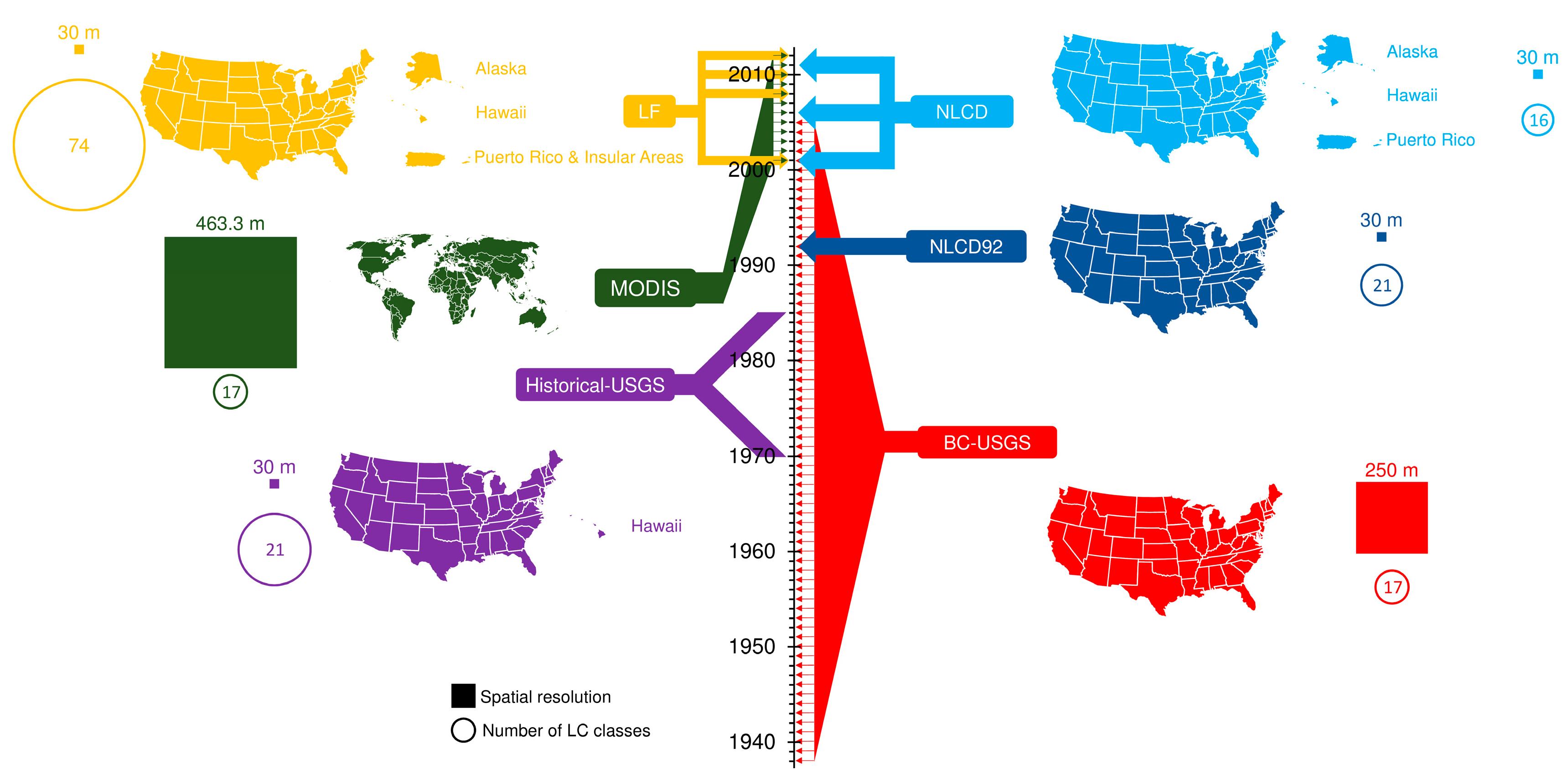
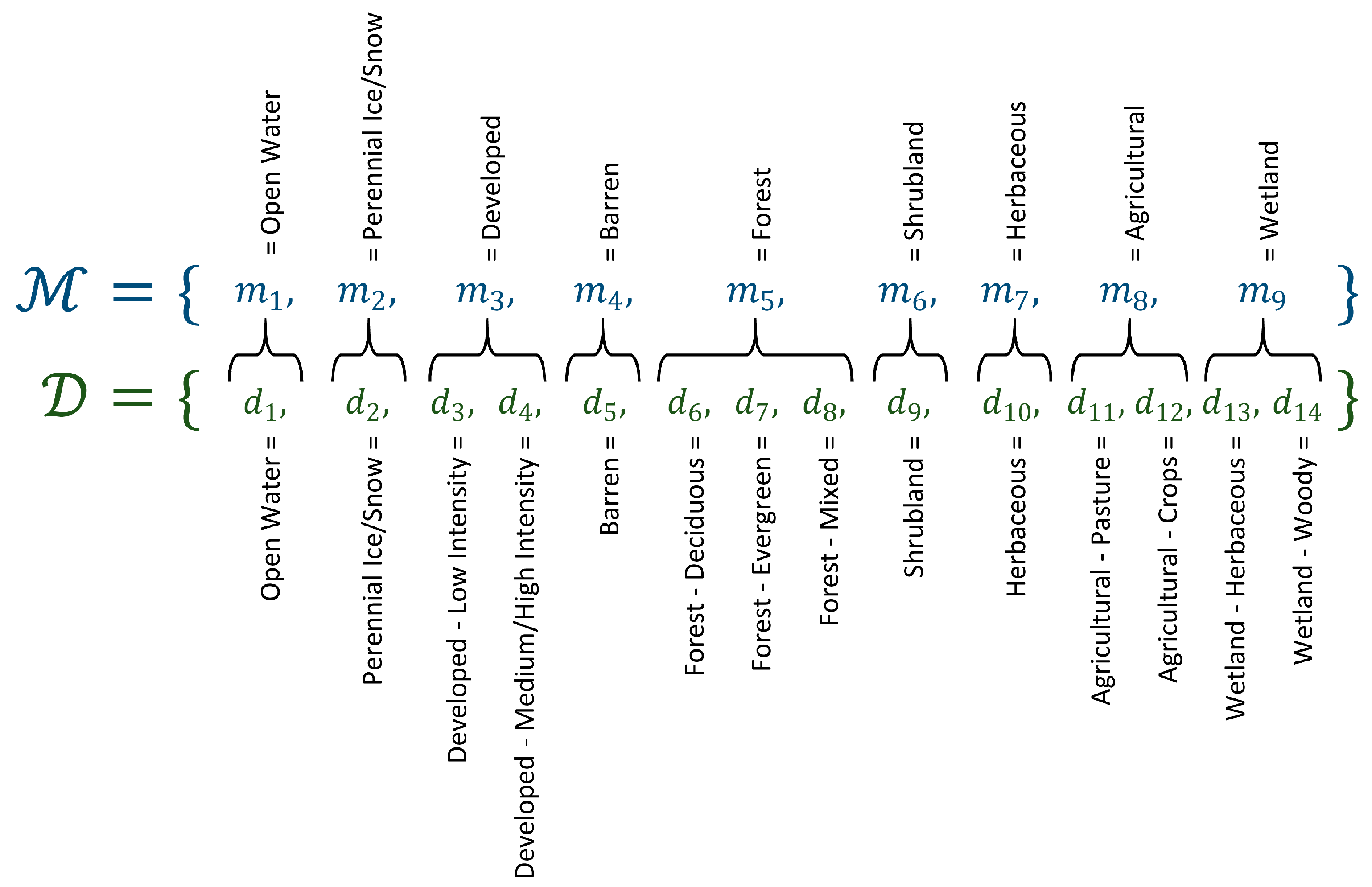
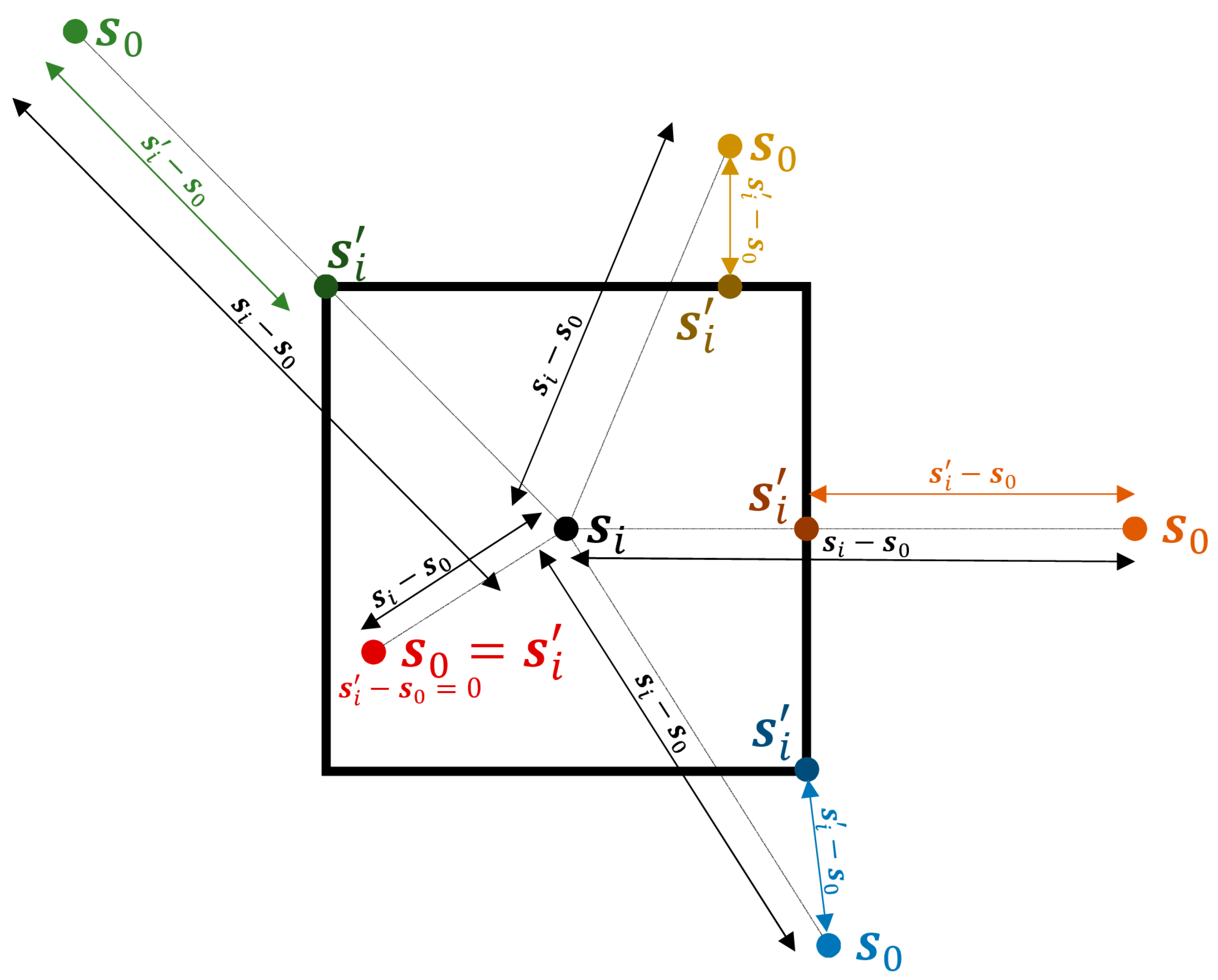
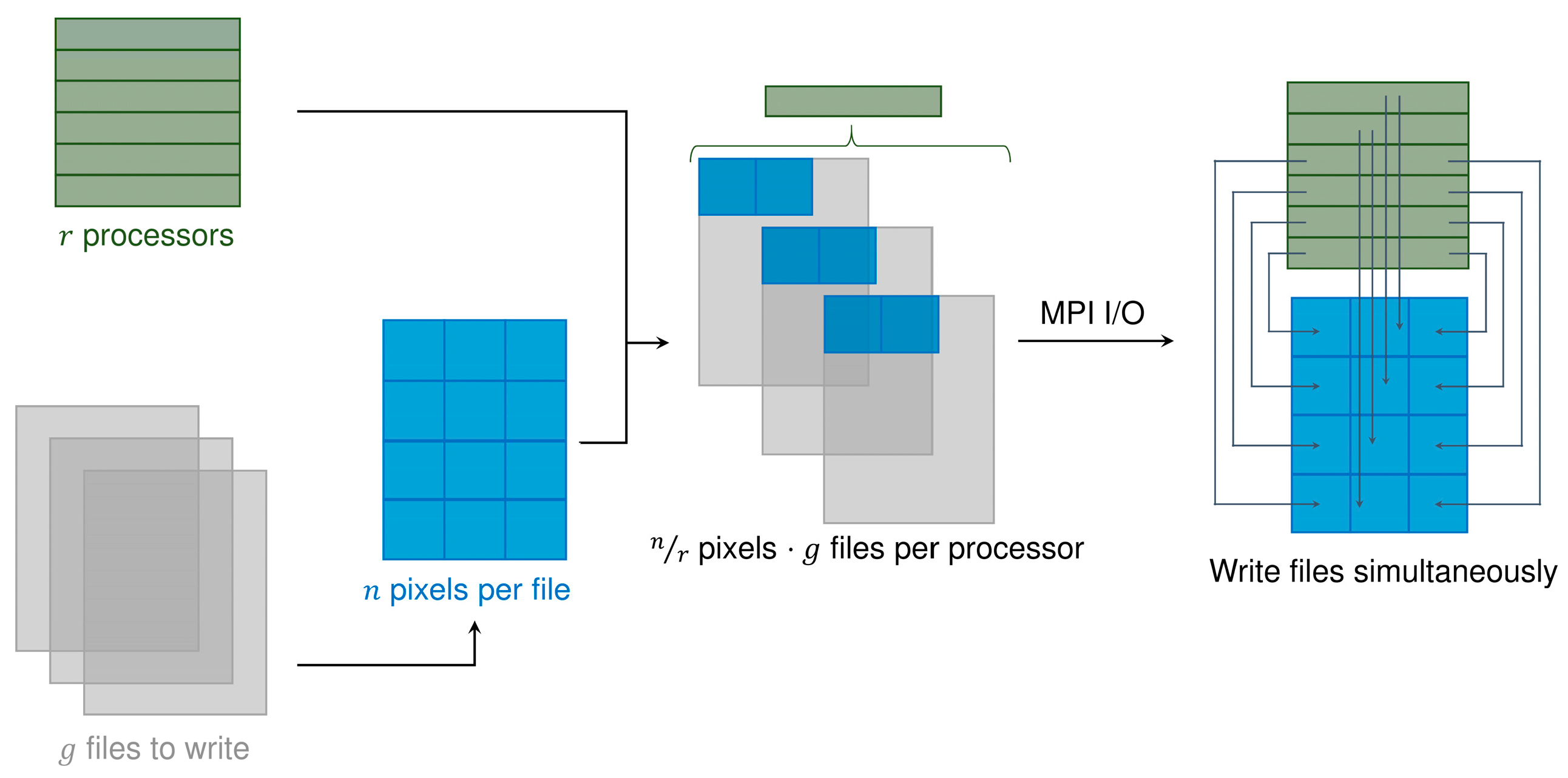


| Ranges | Parameter | Domain | ||||
|---|---|---|---|---|---|---|
| 1 | 2 | 3 | 4 | |||
| (a) | Prediction: mother ranges Agreement: mother ranges | αmax | 0.002 | 0.002 | 0.002 | 0.002 |
| αslope | 1 | 1 | 10 | 500 | ||
| β | 2 | 2 | 2 | 2 | ||
| Q(θ) | 0.7640 | 0.7287 | 0.7803 | 0.8326 | ||
| (b) | Prediction: daughter ranges Agreement: mother ranges | αmax | 0.002 | 0.002 | 0.002 | 0.002 |
| αslope | 1 | 1 | 1 | 500 | ||
| β | 2 | 0.7 | 2 | 2 | ||
| Q(θ) | 0.7641 | 0.7294 | 0.7803 | 0.8325 | ||
| (a) | Prediction: mother ranges Agreement: daughter ranges | αmax | 0.002 | 0.002 | 0.002 | 0.002 |
| αslope | 1 | 1 | 1 | 500 | ||
| β | 2 | 0.7 | 1.7 | 2 | ||
| Q(θ) | 0.7629 | 0.7648 | 0.7775 | 0.8320 | ||
| (b) | Prediction: daughter ranges Agreement: daughter ranges | αmax | 0.002 | 0.002 | 0.002 | 0.002 |
| αslope | 1 | 1 | 1 | 500 | ||
| β | 2 | 0.7 | 2 | 2 | ||
| Q(θ) | 0.7630 | 0.7642 | 0.7777 | 0.8320 | ||
| Feature Combination () | Number of Clusters () | Percentile |
|---|---|---|
| 8 | 76.87% | |
| 9 | 31.46% | |
| 10 | 74.59% | |
| 10 | 52.00% |
© 2017 by the authors. Licensee MDPI, Basel, Switzerland. This article is an open access article distributed under the terms and conditions of the Creative Commons Attribution (CC BY) license (http://creativecommons.org/licenses/by/4.0/).
Share and Cite
Rodríguez-Jeangros, N.; Hering, A.S.; Kaiser, T.; McCray, J.E. SCaMF–RM: A Fused High-Resolution Land Cover Product of the Rocky Mountains. Remote Sens. 2017, 9, 1015. https://doi.org/10.3390/rs9101015
Rodríguez-Jeangros N, Hering AS, Kaiser T, McCray JE. SCaMF–RM: A Fused High-Resolution Land Cover Product of the Rocky Mountains. Remote Sensing. 2017; 9(10):1015. https://doi.org/10.3390/rs9101015
Chicago/Turabian StyleRodríguez-Jeangros, Nicolás, Amanda S. Hering, Timothy Kaiser, and John E. McCray. 2017. "SCaMF–RM: A Fused High-Resolution Land Cover Product of the Rocky Mountains" Remote Sensing 9, no. 10: 1015. https://doi.org/10.3390/rs9101015
APA StyleRodríguez-Jeangros, N., Hering, A. S., Kaiser, T., & McCray, J. E. (2017). SCaMF–RM: A Fused High-Resolution Land Cover Product of the Rocky Mountains. Remote Sensing, 9(10), 1015. https://doi.org/10.3390/rs9101015