
Monitoring Spatio-Temporal Distribution of Rice Planting Area in the Yangtze River Delta Region Using MODIS Images


Abstract
:1. Introduction
2. Study Area and Data
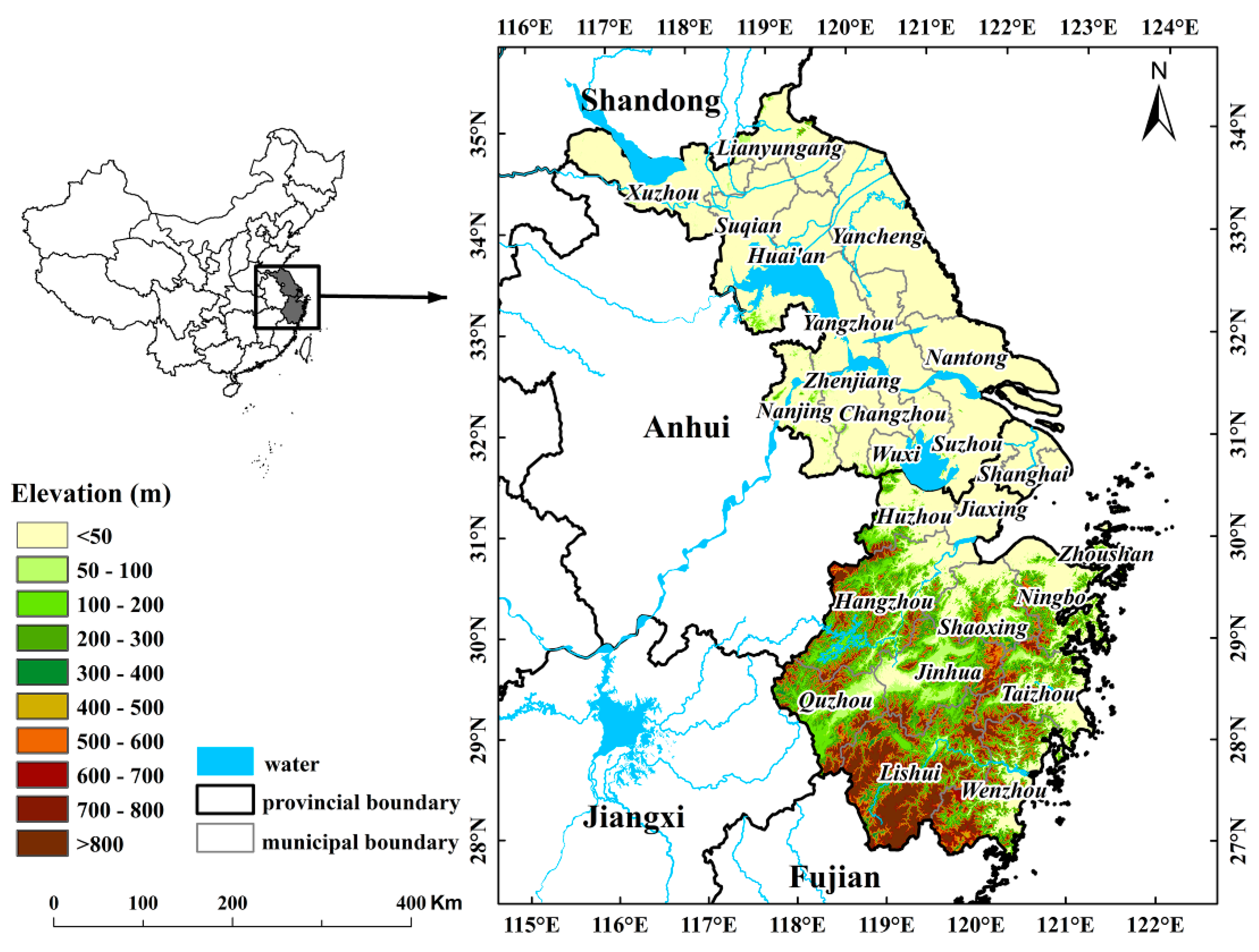
2.1. Study Area
2.2. Data Acquisition
2.2.1. Field Data
2.2.2. Satellite Data
2.2.3. Ancillary Data
3. Methodology
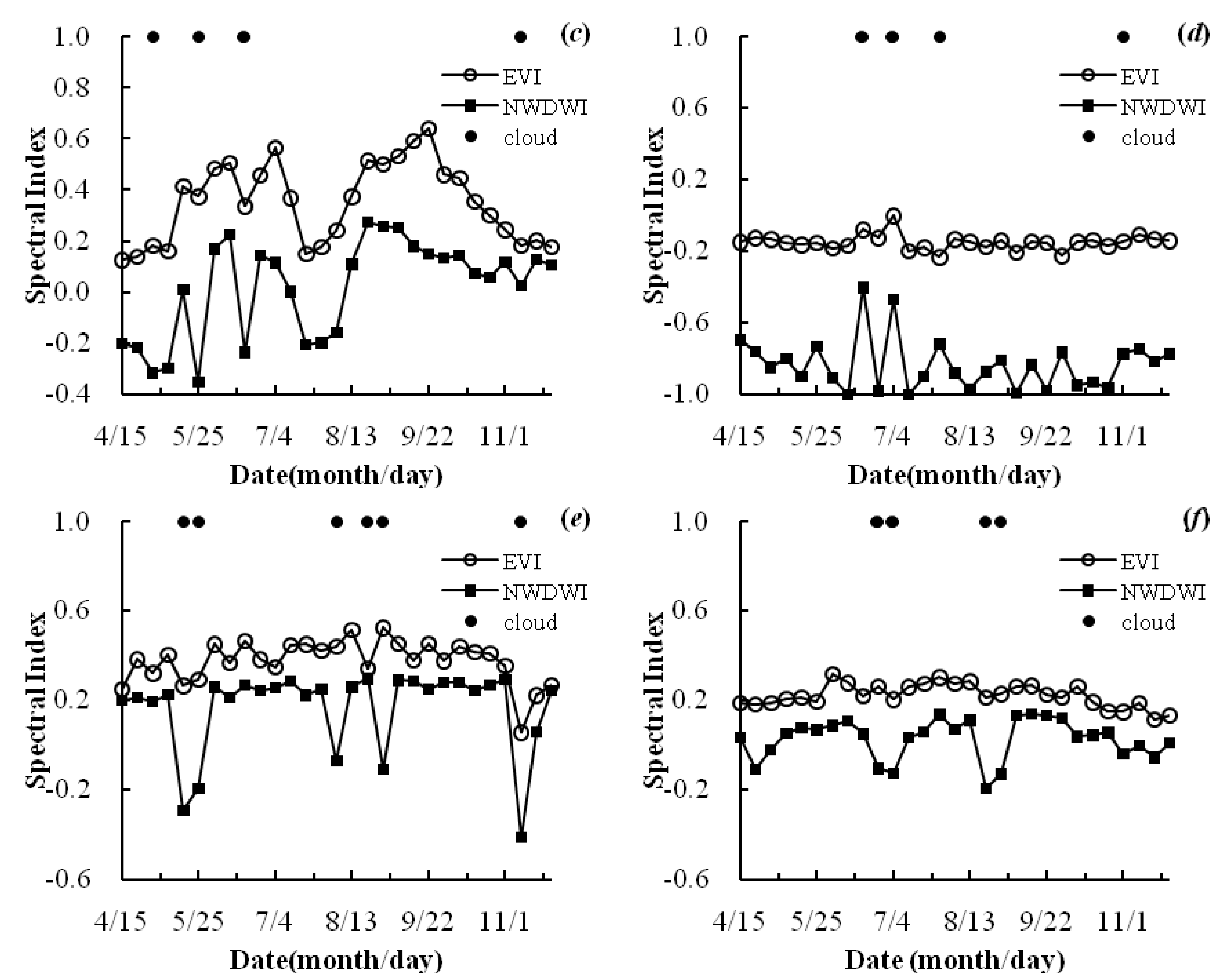
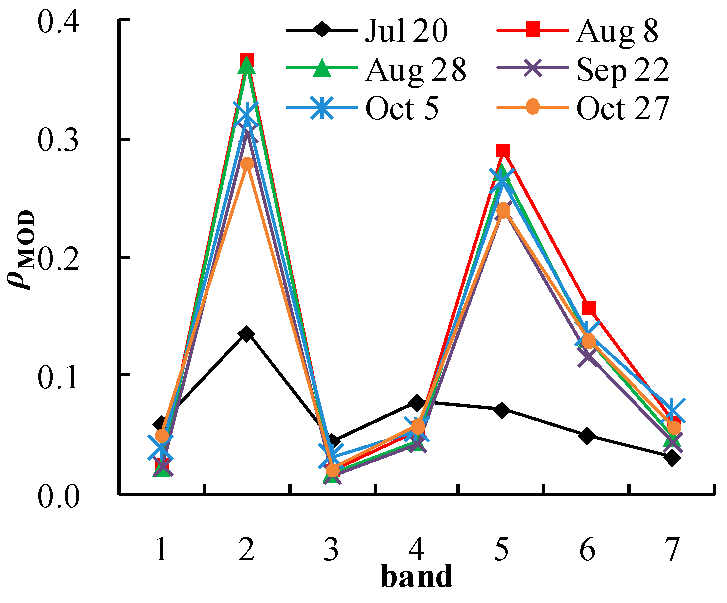
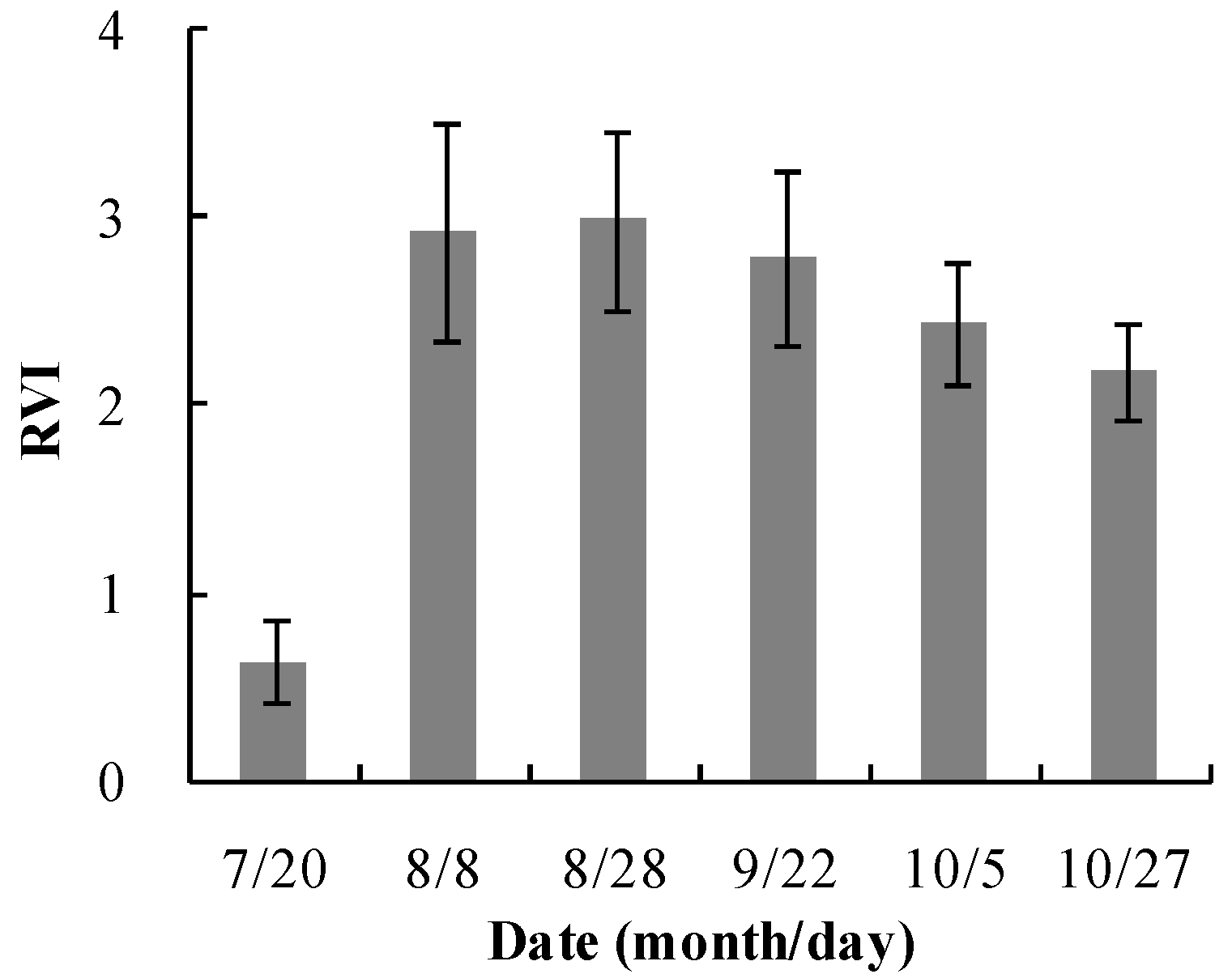
3.1. Spectral Characteristics of Rice during the Flooding and Transplanting Period


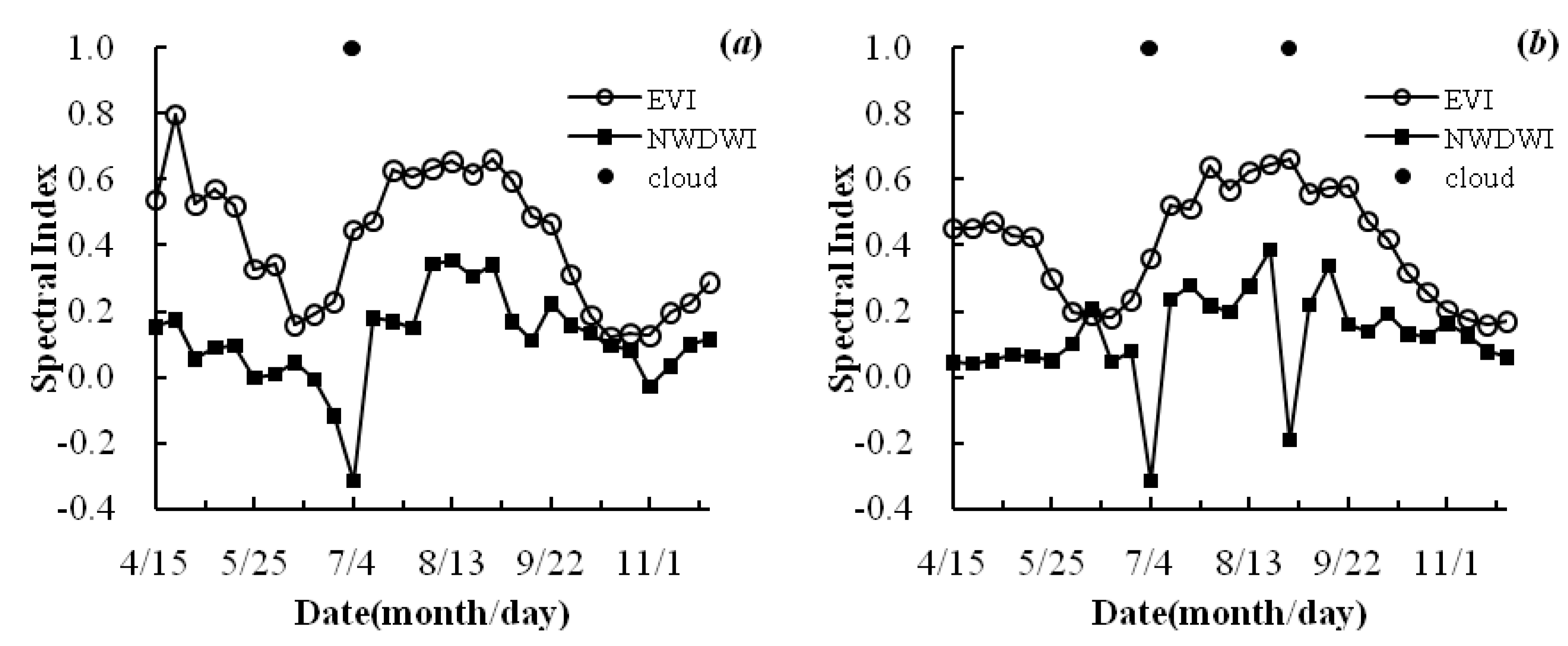
3.2. Reconstruction of the Spectral Index Profile
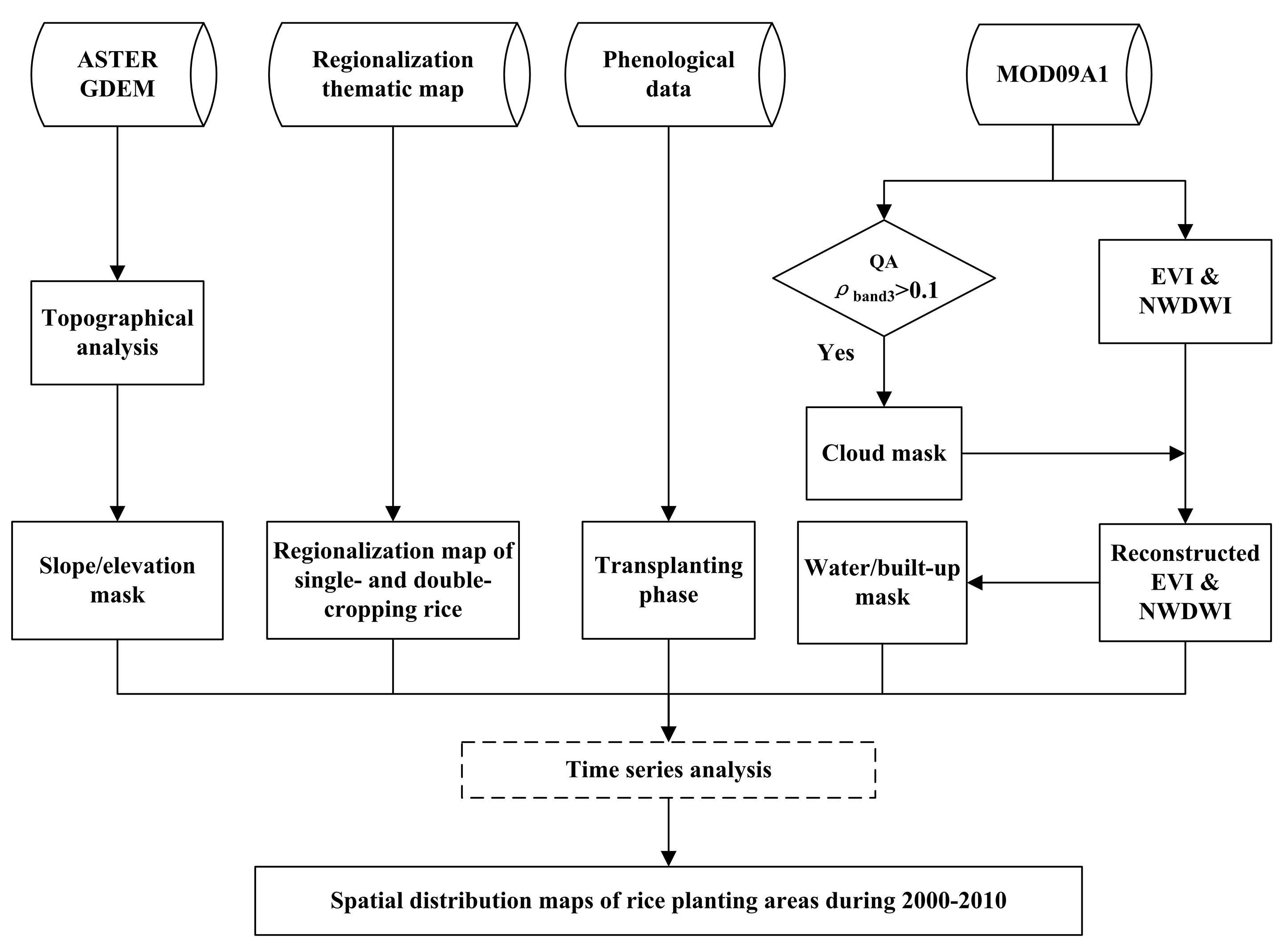
3.3. Algorithm for Mapping Rice Planting Areas Using Time Series MODIS Data


3.4. Accuracy Assessment
4. Results and Discussion
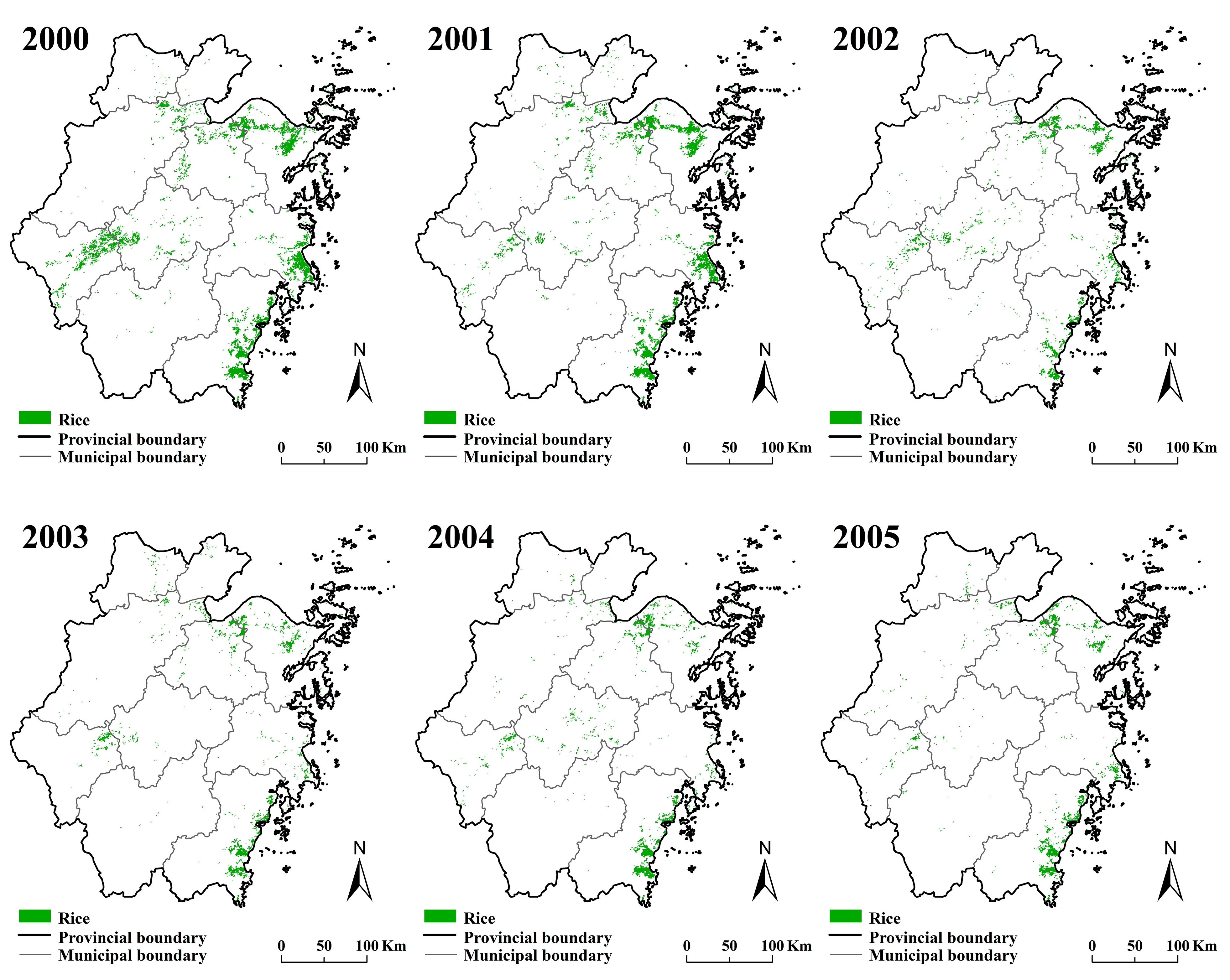
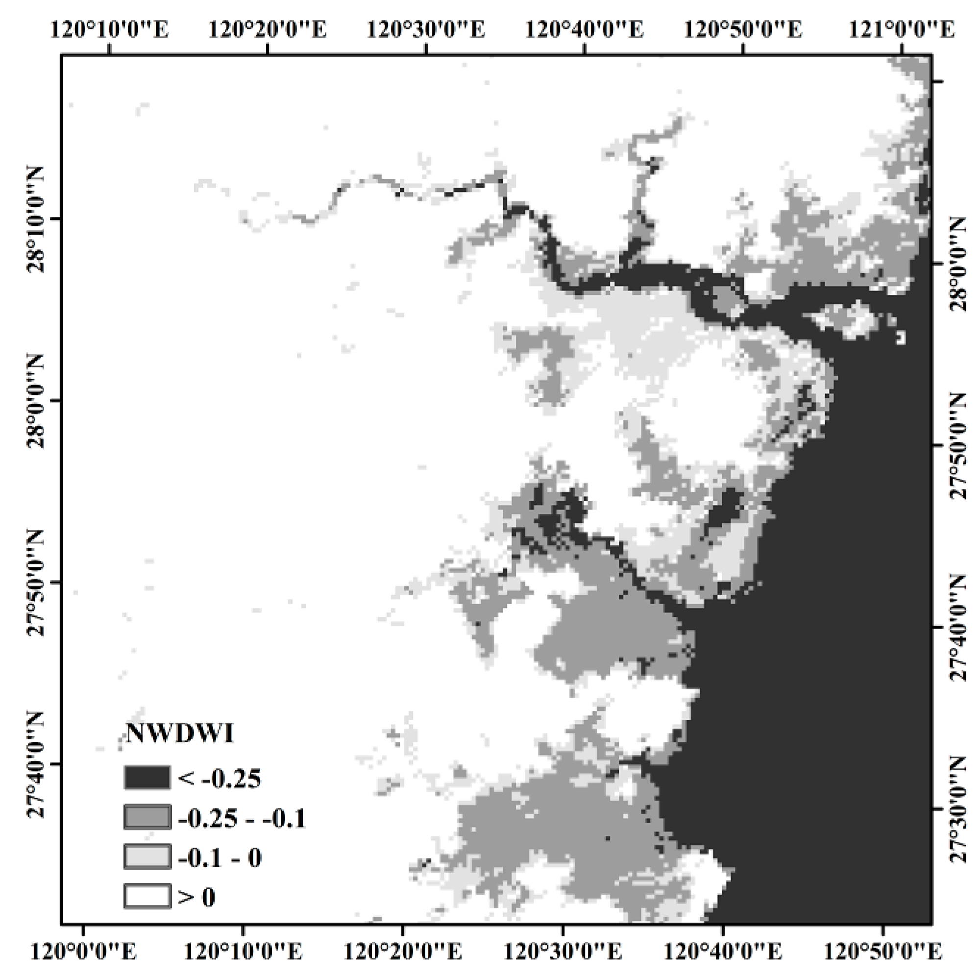
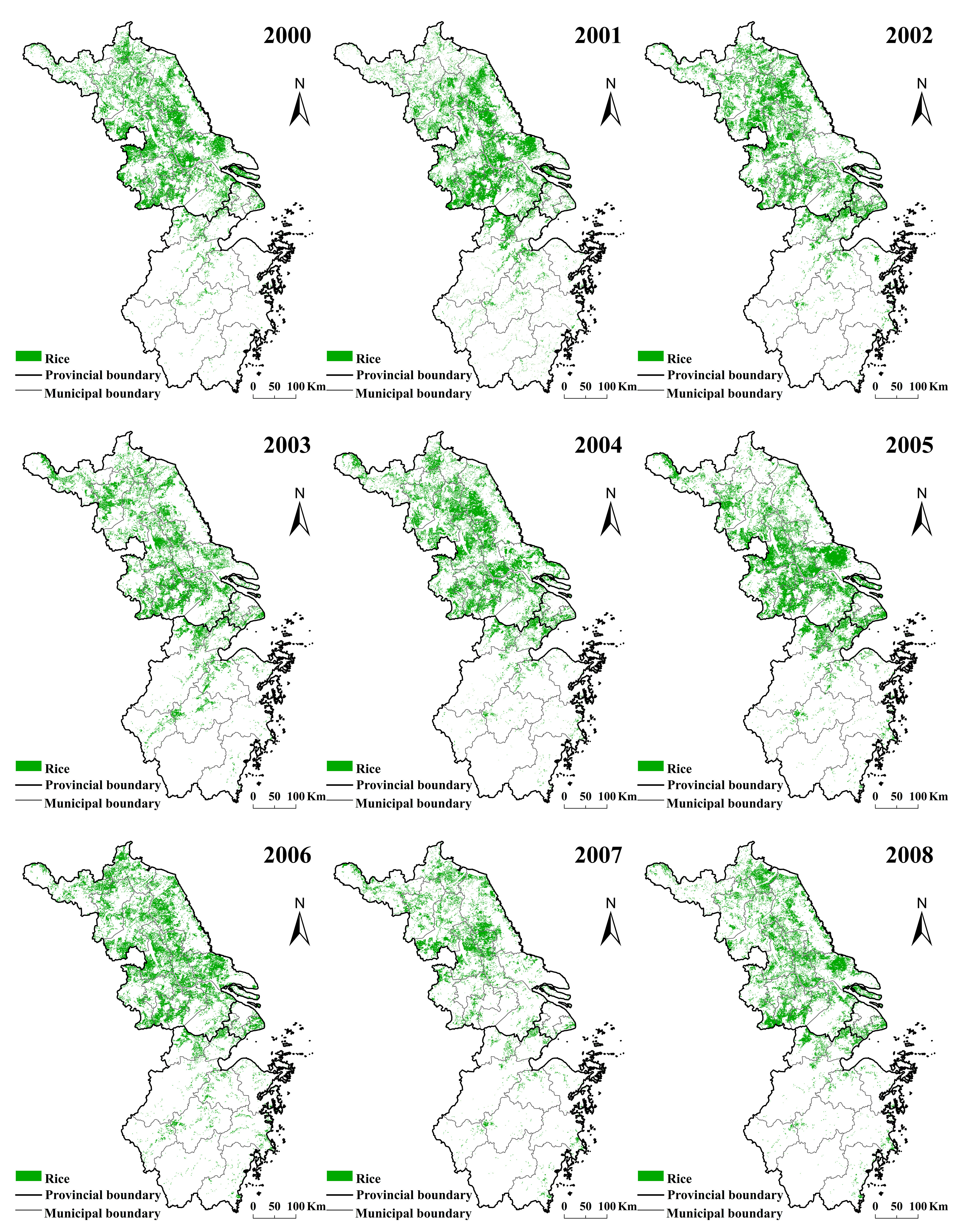
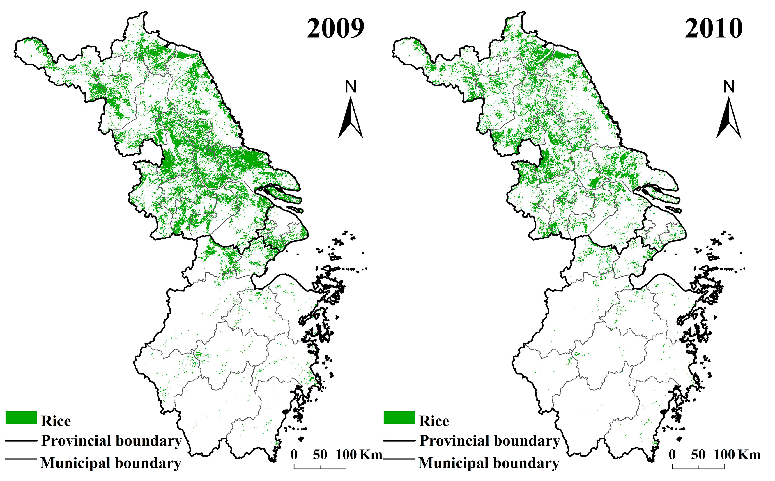
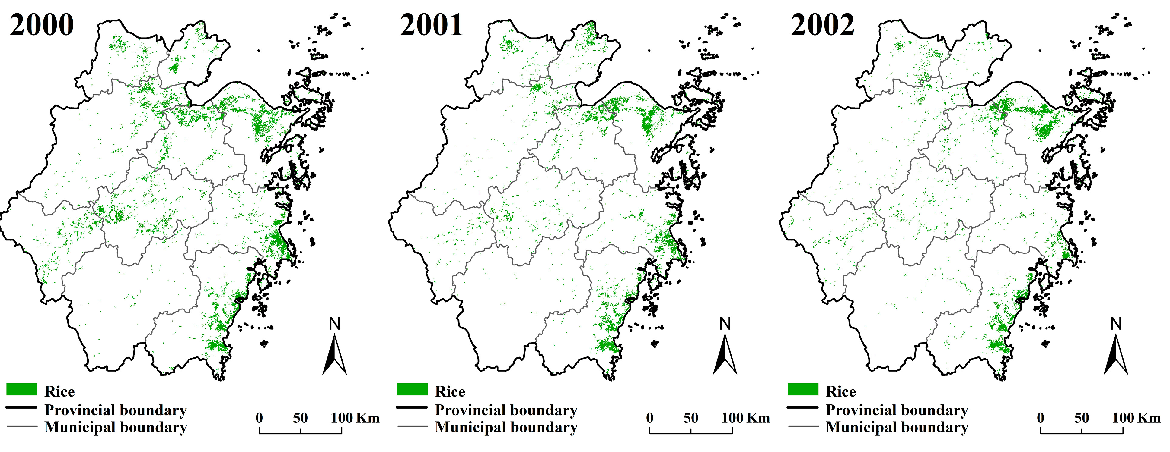
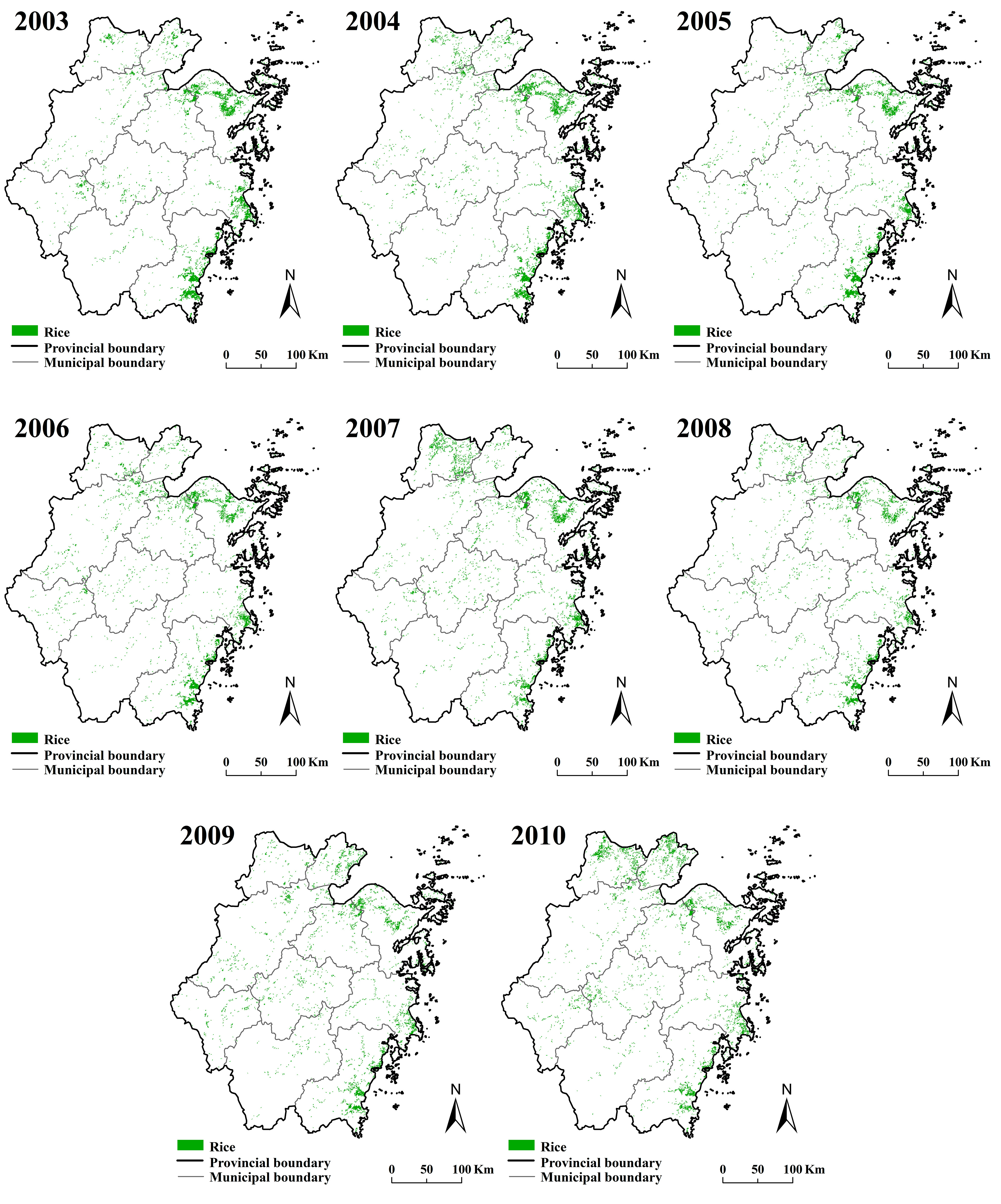
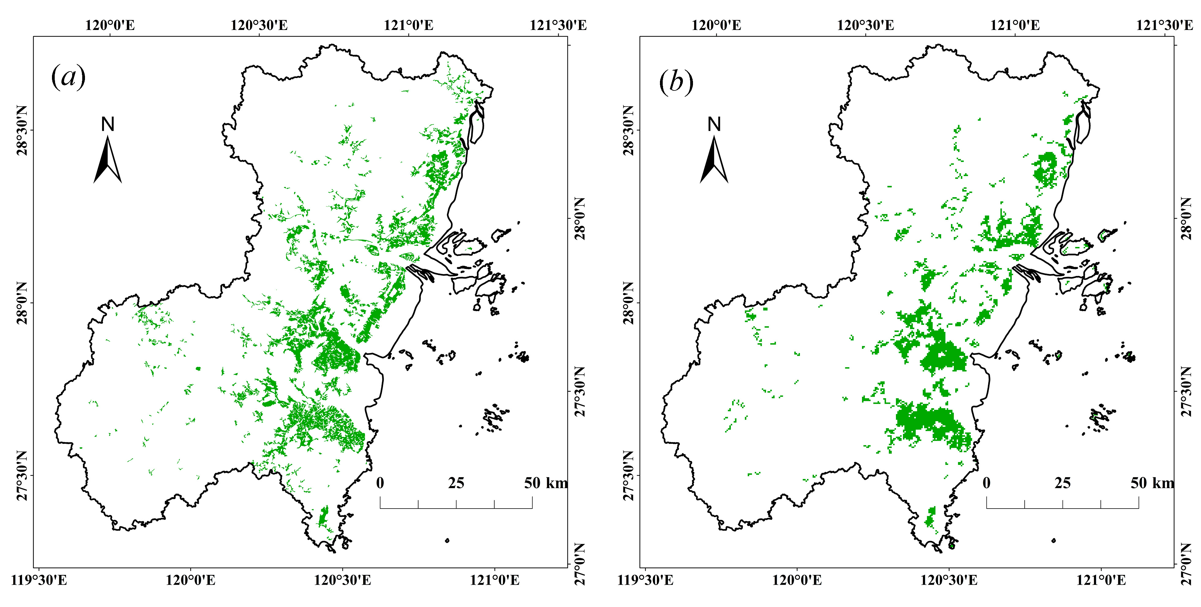
4.1. Spatial and Temporal Distribution of Rice Planting Areas in the Yangtze River Delta Region


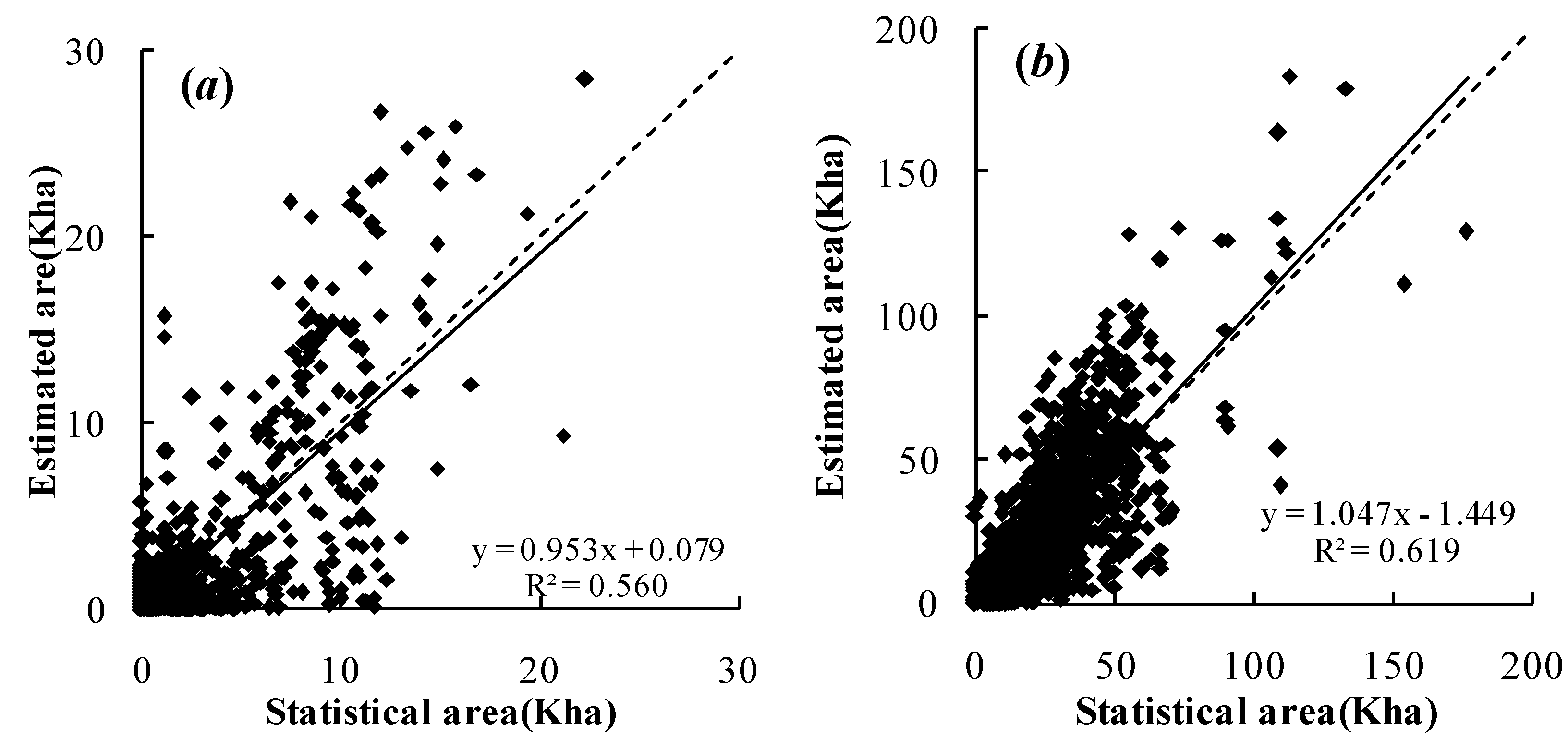
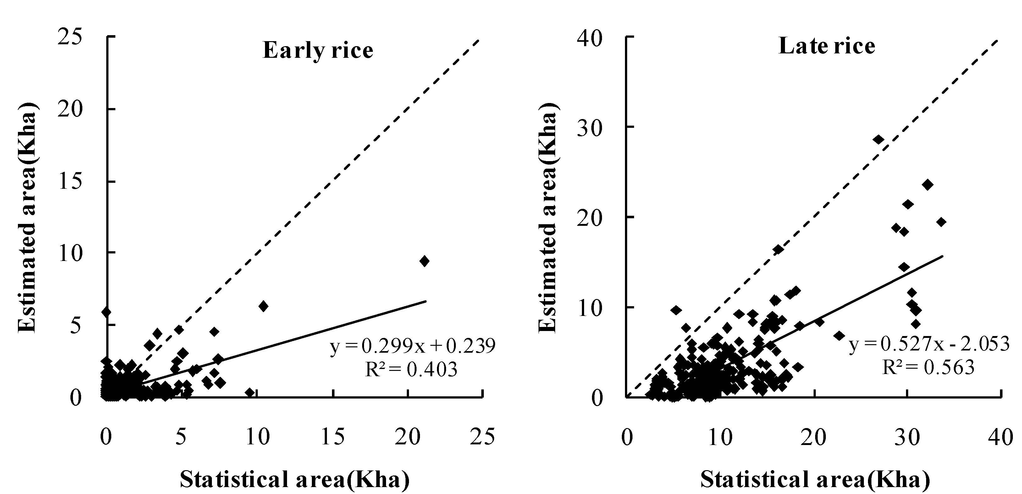
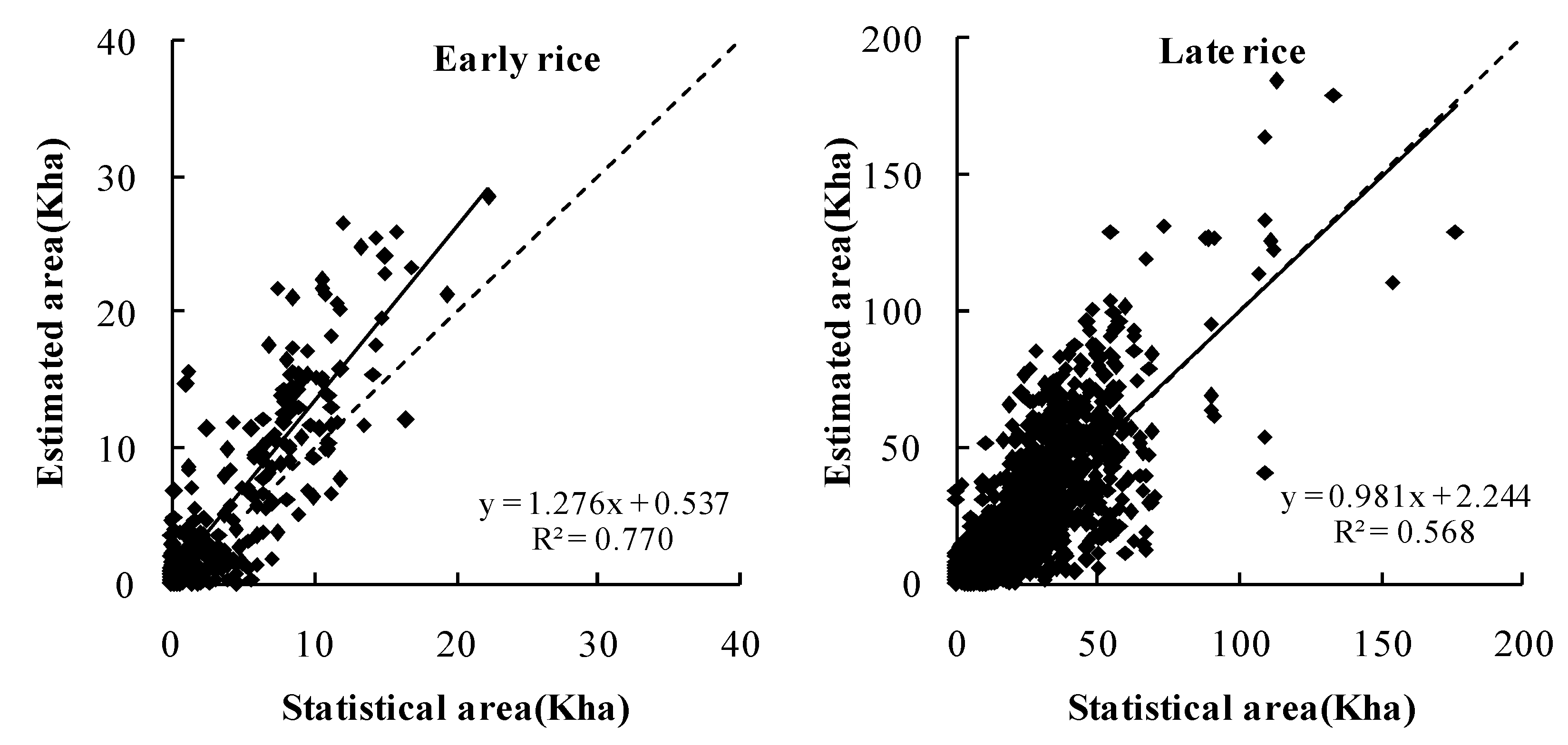
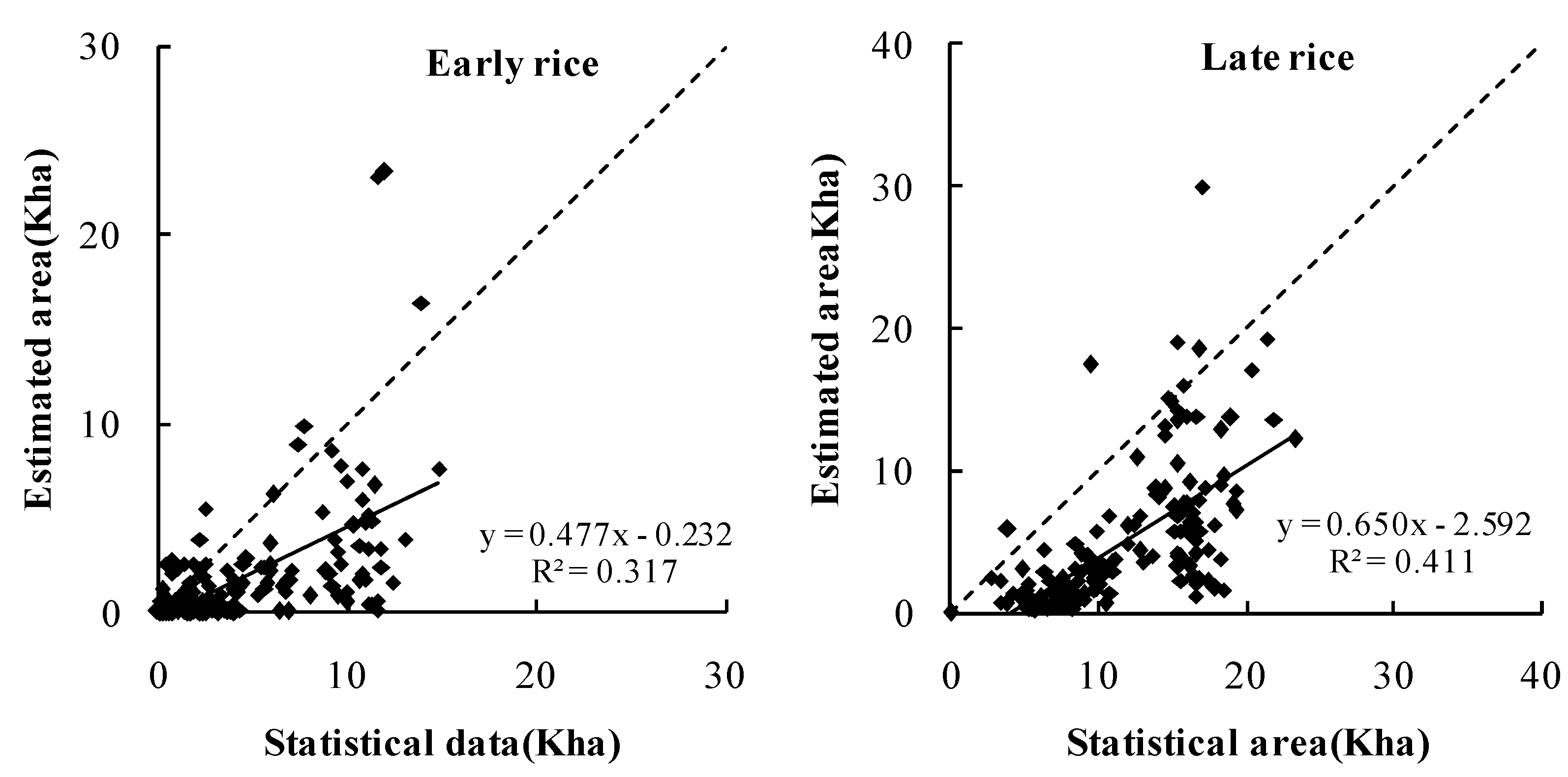
4.2. Comparison of the Estimated Paddy Rice Planting Areas with Agricultural Census Data

| Year | Census Data (kha) | * RiceMOD (kha) | Relative Error (%) |
|---|---|---|---|
| 2000 | 3928.50 | 3882.06 | −11.8 |
| 2001 | 3476.30 | 3753.93 | 7.99 |
| 2002 | 3239.83 | 3472.60 | 7.18 |
| 2003 | 2842.23 | 3161.56 | 11.24 |
| 2004 | 3285.70 | 3576.88 | 8.86 |
| 2005 | 3409.26 | 3609.66 | 5.88 |
| 2006 | 3439.45 | 3638.51 | 5.79 |
| 2007 | 3338.49 | 2140.38 | −35.89 |
| 2008 | 3359.37 | 2893.90 | −13.86 |
| 2009 | 3335.40 | 3546.10 | 6.32 |
| 2010 | 3309.10 | 2636.50 | −20.33 |


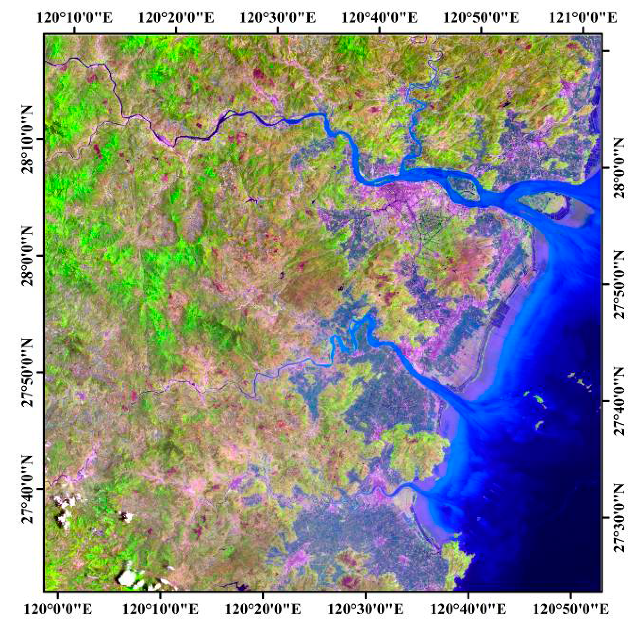
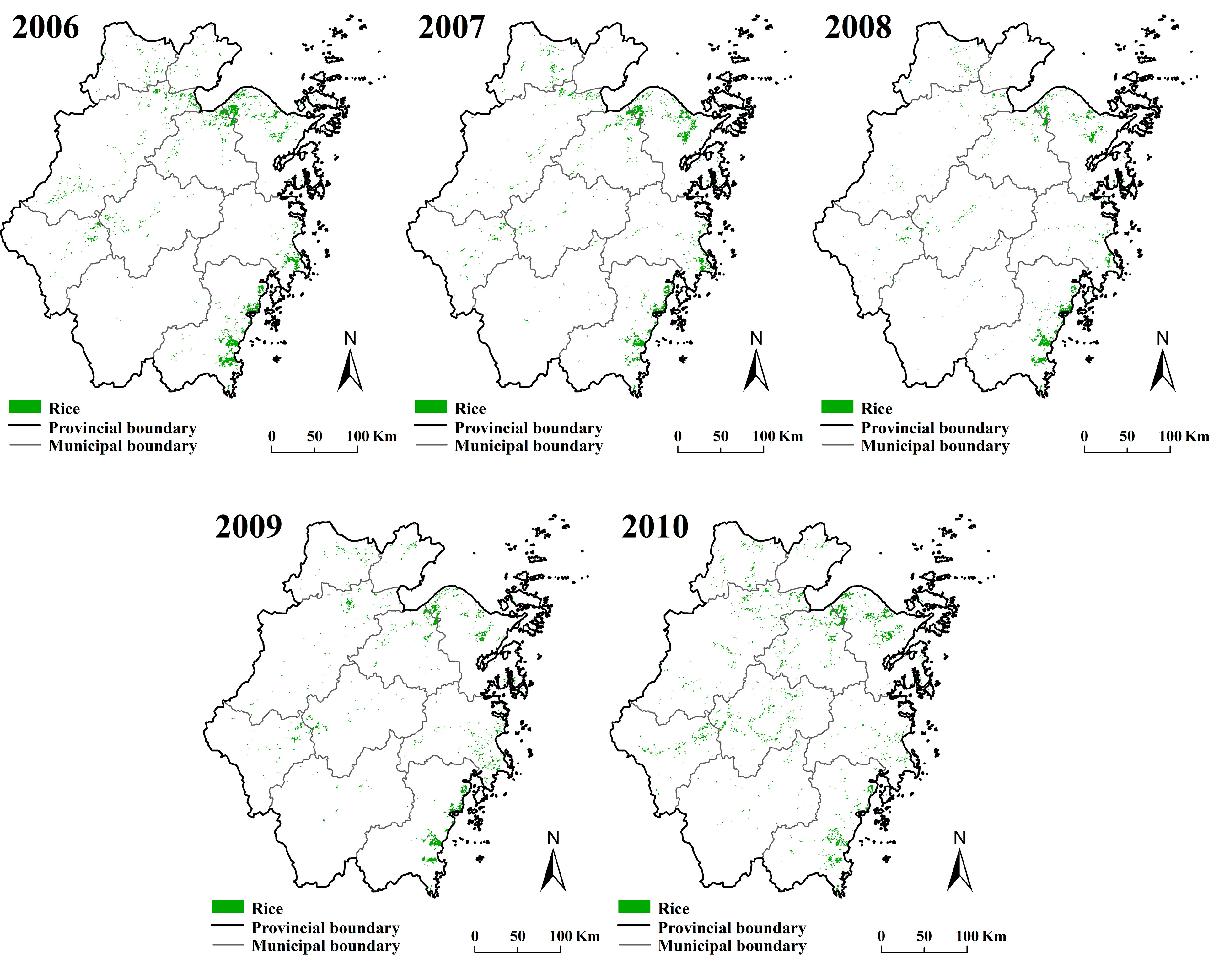
4.3. Spatial Comparison of Extracted Paddy Rice Planting Areas
| Level | Commission Error (%) | User’s Accuracy (%) | Omission Error (%) | Producer’s Accuracy (%) |
|---|---|---|---|---|
| Pixel level | 26.30 | 73.70 | 22.67 | 77.33 |
| 3 × 3 window | 3.23 | 96.77 | 0.04 | 99.96 |

| City | Number of Rice Pixels Located in Irrigated Paddies | Number of RiceMOD * | Overlap Proportion (%) | Area of Irrigated Paddies (kha) | Area of RiceMOD (km2) |
|---|---|---|---|---|---|
| Yueqing | 832 | 888 | 93.69 | 21.38 | 19.06 |
| Pingyang | 586 | 625 | 93.76 | 16.50 | 13.42 |
| Wencheng | 55 | 93 | 59.14 | 3.51 | 2.00 |
| Yongjia | 178 | 238 | 74.79 | 7.99 | 5.11 |
| Taishun | 5 | 53 | 9.43 | 0.66 | 1.14 |
| Dongtou | 3 | 52 | 5.77 | 0.06 | 1.12 |
| Wenzhou | 371 | 440 | 84.32 | 12.44 | 9.44 |
| Rui’an | 810 | 878 | 92.26 | 25.08 | 18.85 |
| Cangnan | 993 | 1042 | 95.30 | 22.10 | 22.37 |
| Total | 3833 | 4309 | 88.95 | 109.70 | 92.50 |
5. Conclusions
Acknowledgments
Author Contributions
Conflicts of Interest
References
- Khush, G.S. What it will take to feed 5.0 billion rice consumers in 2030? Plant Mol. Biol. 2005, 59, 1–6. [Google Scholar] [CrossRef] [PubMed]
- Food and Agriculture Organziation of the United Nations. Statistical Yearbook 2013: World Food and Agriculture; FAO: Rome, Italy, 2013. [Google Scholar]
- Frolking, S.; Qiu, J.J.; Boles, S.; Xiao, X.M.; Liu, J.Y.; Zhuang, Y.H.; Li, C.S.; Qin, X.G. Combining remote sensing and ground census data to develop new maps of the distribution of rice agriculture in China. Glob. Biogeochem. Cycles 2002, 16, 31–38. [Google Scholar] [CrossRef]
- Huke, R.E.; Huke, E.H. Rice Area by Type of Culture: South, Southeast, and East Asia. A Review and Updated Data Base; IRRI: Los Baños, Philippines, 1997. [Google Scholar]
- Leff, B.; Ramankutty, N.; Foley, J.A. Geographic distribution of major crops across the world. Glob. Biogeochem. Cycles 2004, 18, GB1009. [Google Scholar] [CrossRef]
- Liu, J.Y.; Liu, M.L.; Zhuang, D.F.; Zhang, Z.X.; Deng, X.Z. Study on spatial pattern of land-use change in China during 1995–2000. Sci. China Ser. D: Earth Sci. 2003, 46, 373–384. [Google Scholar]
- McCloy, K.R.; Smith, F.R.; Robinson, M.R. Monitoring rice areas using Landsat MSS data. Int. J. Remote Sens. 1987, 8, 741–749. [Google Scholar] [CrossRef]
- Oguro, Y.; Suga, Y.; Takeuchi, S.; Ogawa, H.; Tsuchiya, K. Monitoring of a rice field using Landsat-5 TM and Landsat-7 ETM+ data. Adv. Space Res. 2003, 32, 2223–2228. [Google Scholar] [CrossRef]
- Okamoto, K.; Fukuhara, M. Estimation of paddy field area using the area ratio of categories in each mixel of Landsat TM. Int. J. Remote Sens. 1996, 17, 1735–1749. [Google Scholar] [CrossRef]
- Li, Y.Z.; Zeng, Y. Study on methods of rice planting area estimation at regional scale using NOAA/AVHRR data. J. Remote Sens. 1998, 2, 125–130. (In Chinese) [Google Scholar]
- Andres, L.; Salas, W.A.; Skole, D. Fourier analysis of multi-temporal AVHRR data applied to a land cover classification. Int. J. Remote Sens. 1994, 15, 1115–1121. [Google Scholar] [CrossRef]
- Xiao, X.; Boles, S.; Frolking, S.; Salas, W.; Moore, B.; Li, C.; He, L.; Zhao, R. Observation of flooding and rice transplanting of paddy rice fields at the site to landscape scales in China using VEGETATION sensor data. Int. J. Remote Sens. 2002, 23, 3009–3022. [Google Scholar] [CrossRef]
- Quarmby, N.A. Towards continental scale crop area estimation. Int. J. Remote Sens. 1992, 13, 981–989. [Google Scholar] [CrossRef]
- Gumma, M.K.; Gauchan, D.; Nelson, A.; Pandey, S.; Rala, A. Temporal changes in rice-growing area and their impact on livelihood over a decade: A case study of Nepal. Agric. Ecosyst. Environ. 2011, 142, 382–392. [Google Scholar] [CrossRef]
- Gumma, M.K.; Nelson, A.; Thenkabail, P.S.; Singh, A.N. Mapping rice areas of south Asia using MODIS multitemporal data. J. Appl. Remote Sens. 2011, 5. [Google Scholar] [CrossRef]
- Sakamoto, T.; Yokozawa, M.; Toritani, H.; Shibayama, M.; Ishitsuka, N.; Ohno, H. A crop phenology detection method using time-series MODIS data. Remote Sens. Environ. 2005, 96, 366–374. [Google Scholar] [CrossRef]
- Zhang, X.Y.; Friedl, M.A.; Schaaf, C.B.; Strahler, A.H.; Hodges, J.C.F.; Gao, F.; Reed, B.C.; Huete, A. Monitoring vegetation phenology using MODIS. Remote Sens. Environ. 2003, 84, 471–475. [Google Scholar] [CrossRef]
- Neue, H.U. Methane emission from rice fields. Bioscience 1993, 43, 466–474. [Google Scholar] [CrossRef]
- Quarmby, N.A.; Milnes, M.; Hindle, T.L.; Silleos, N. The use of multi-temporal NDVI measurements from AVHRR data for crop yield estimation and prediction. Int. J. Remote Sens. 1993, 14, 199–210. [Google Scholar] [CrossRef]
- Lunetta, R.S.; Knight, J.F.; Ediriwickrema, J.; Lyon, J.G.; Worthy, L.D. Land-cover change detection using multi-temporal MODIS NDVI data. Remote Sens. Environ. 2006, 105, 142–154. [Google Scholar] [CrossRef]
- Huete, A.R.; Liu, H.Q.; Batchily, K.; van Leeuwen, W. A comparison of vegetation indices over a global set of TM images for EOS-MODIS. Remote Sens. Environ. 1997, 59, 440–451. [Google Scholar] [CrossRef]
- Huete, A.; Didan, K.; Miura, T.; Rodriguez, E.P.; Gao, X.; Ferreira, L.G. Overview of the radiometric and biophysical performance of the MODIS vegetation indices. Remote Sens. Environ. 2002, 83, 195–213. [Google Scholar] [CrossRef]
- McFeeters, S.K. The use of the Normalized Difference Water Index (NDWI) in the delineation of open water features. Int. J. Remote Sens. 1996, 17, 1425–1432. [Google Scholar] [CrossRef]
- Xu, H.Q. Modification of Normalised Difference Water Index (NDWI) to enhance open water features in remotely sensed imagery. Int. J. Remote Sens. 2006, 27, 3025–3033. [Google Scholar] [CrossRef]
- Xiao, X.M.; Boles, S.; Liu, J.Y.; Zhuang, D.F.; Frolking, S.; Li, C.S.; Salas, W.; Moore, B. Mapping paddy rice agriculture in southern China using multi-temporal MODIS images. Remote Sens. Environ. 2005, 95, 480–492. [Google Scholar] [CrossRef]
- Qiu, B.W.; Li, W.J.; Tang, Z.H.; Chen, C.C.; Qi, W. Mapping paddy rice areas based on vegetation phenology and surface moisture conditions. Ecol. Indic. 2015, 56, 79–86. [Google Scholar] [CrossRef]
- Mosleh, M.K.; Hassan, Q.K. Development of a remote sensing-based “Boro” rice mapping system. Remote Sens. 2014, 6, 1938–1953. [Google Scholar] [CrossRef]
- Yi, S.; Saito, Y.; Zhao, Q.H.; Wang, P.X. Vegetation and climate changes in the Changjiang (Yangtze river) delta, China, during the past 13,000 years inferred from pollen records. Quat. Sci. Rev. 2003, 22, 1501–1519. [Google Scholar] [CrossRef]
- Vermote, E.F.; Vermeulen, A. Atmospheric Correction Algorithm: Spectral Reflectance (MOD09), MODIS Algorithm Technical Background Document, version 4.0; University of Maryland: Maryland, MD, USA, 1999. [Google Scholar]
- Gitelson, A.A.; Kaufman, Y.J.; Merzlyak, M.N. Use of a green channel in remote sensing of global vegetation from EOS-MODIS. Remote Sens. Environ. 1996, 58, 289–298. [Google Scholar] [CrossRef]
- Spruce, J.P.; Sader, S.; Ryan, R.E.; Smoot, J.; Kuper, P.; Ross, K.; Prados, D.; Russell, J.; Gasser, G.; McKellip, R.; et al. Assessment of MODIS NDVI time series data products for detecting forest defoliation by gypsy moth outbreaks. Remote Sens. Environ. 2011, 115, 427–437. [Google Scholar] [CrossRef]
- Groten, S. NDVI—Crop monitoring and early yield assessment of Burkina Faso. Int. J. Remote Sens. 1993, 14, 1495–1515. [Google Scholar] [CrossRef]
- Sun, H.S.; Huang, J.F.; Li, B.; Wang, H.S. Study on the regionalization of paddy rice information acquirement through remote sensing technology in China. Sci. Agric. Sin. 2008, 41, 4039–4047. [Google Scholar]
- Cheng, Q.; Wang, R.C. Estimation of the rice planting area using digital elevation model and multitemporal moderate resolution imaging spectroradiometer. Trans. Chin. Soc. Agric. Eng. 2005, 21, 89–92. (In Chinese) [Google Scholar]
- Zhan, X.; Defries, R.; Townshend, J.R.G.; Dimiceli, C.; Hansen, M.; Huang, C.; Sohlberg, R. The 250 m global land cover change product from the Moderate Resolution Imaging Spectroradiometer of NASA’s Earth Observing System. Int. J. Remote Sens. 2000, 21, 1433–1460. [Google Scholar] [CrossRef]
- Xu, H.W.; Wang, K. Regionalization for rice yield estimation by remote sensing in Zhejiang Province. Pedosphere 2001, 11, 175–184. [Google Scholar]
© 2015 by the authors; licensee MDPI, Basel, Switzerland. This article is an open access article distributed under the terms and conditions of the Creative Commons Attribution license (http://creativecommons.org/licenses/by/4.0/).
Share and Cite
Shi, J.; Huang, J. Monitoring Spatio-Temporal Distribution of Rice Planting Area in the Yangtze River Delta Region Using MODIS Images. Remote Sens. 2015, 7, 8883-8905. https://doi.org/10.3390/rs70708883
Shi J, Huang J. Monitoring Spatio-Temporal Distribution of Rice Planting Area in the Yangtze River Delta Region Using MODIS Images. Remote Sensing. 2015; 7(7):8883-8905. https://doi.org/10.3390/rs70708883
Chicago/Turabian StyleShi, Jingjing, and Jingfeng Huang. 2015. "Monitoring Spatio-Temporal Distribution of Rice Planting Area in the Yangtze River Delta Region Using MODIS Images" Remote Sensing 7, no. 7: 8883-8905. https://doi.org/10.3390/rs70708883
APA StyleShi, J., & Huang, J. (2015). Monitoring Spatio-Temporal Distribution of Rice Planting Area in the Yangtze River Delta Region Using MODIS Images. Remote Sensing, 7(7), 8883-8905. https://doi.org/10.3390/rs70708883