Assessment of the MODIS LAI Product Using Ground Measurement Data and HJ-1A/1B Imagery in the Meadow Steppe of Hulunber, China



Abstract
1. Introduction
2. Experiment Descriptions
2.1. Site Description
2.2. Sample Design and Field Measurements
3. Data Analysis and LAI Mapping
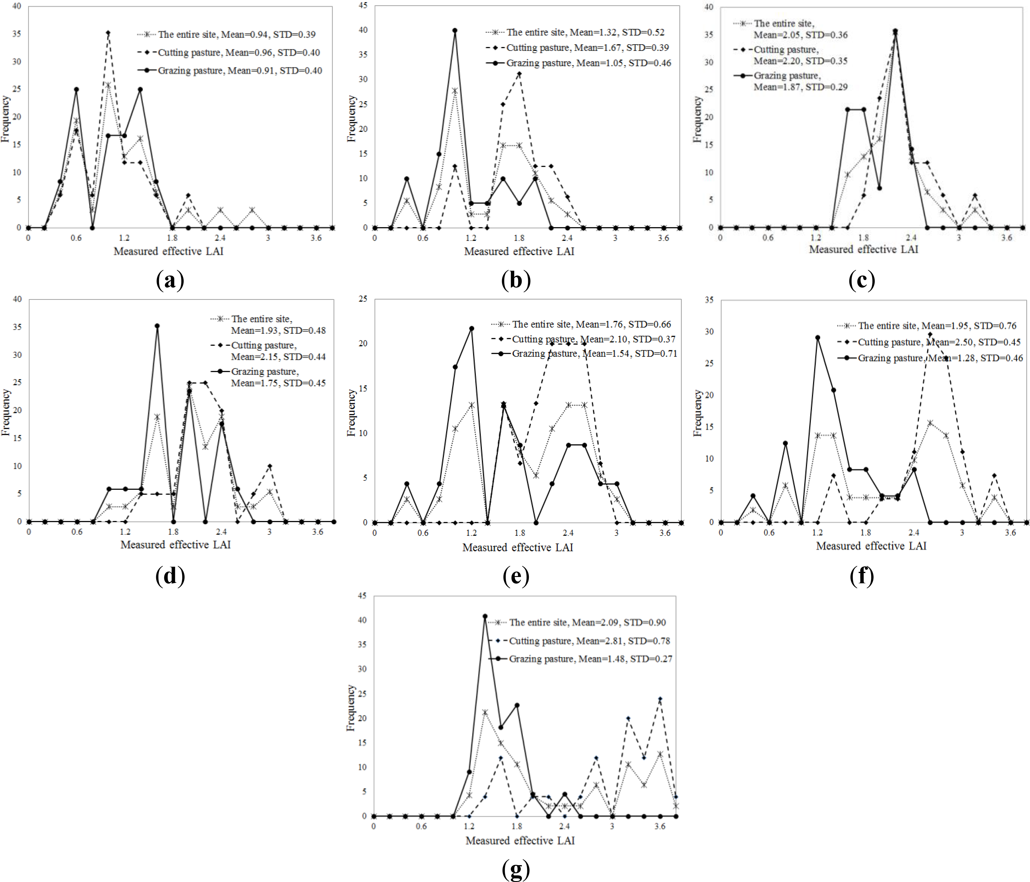
3.1. In Situ LAI Data
3.2. HJ-1A/B CCD Imagery and Preprocessing
3.3. MODIS Products and Preprocessing
3.4. LAI Modeling and Mapping
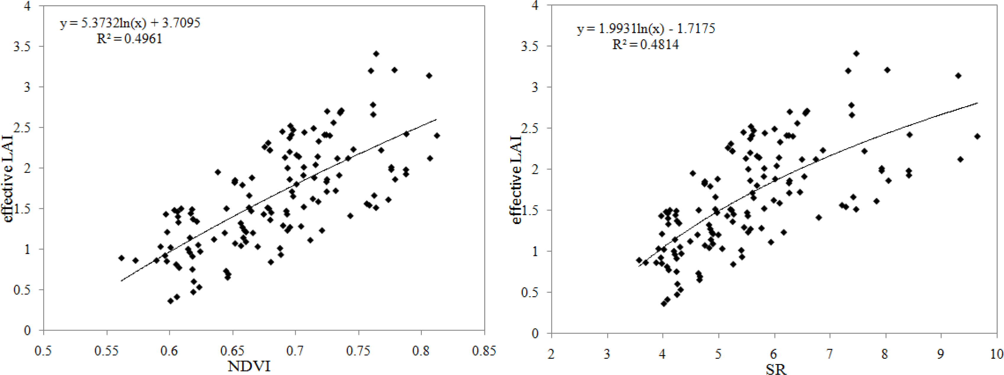
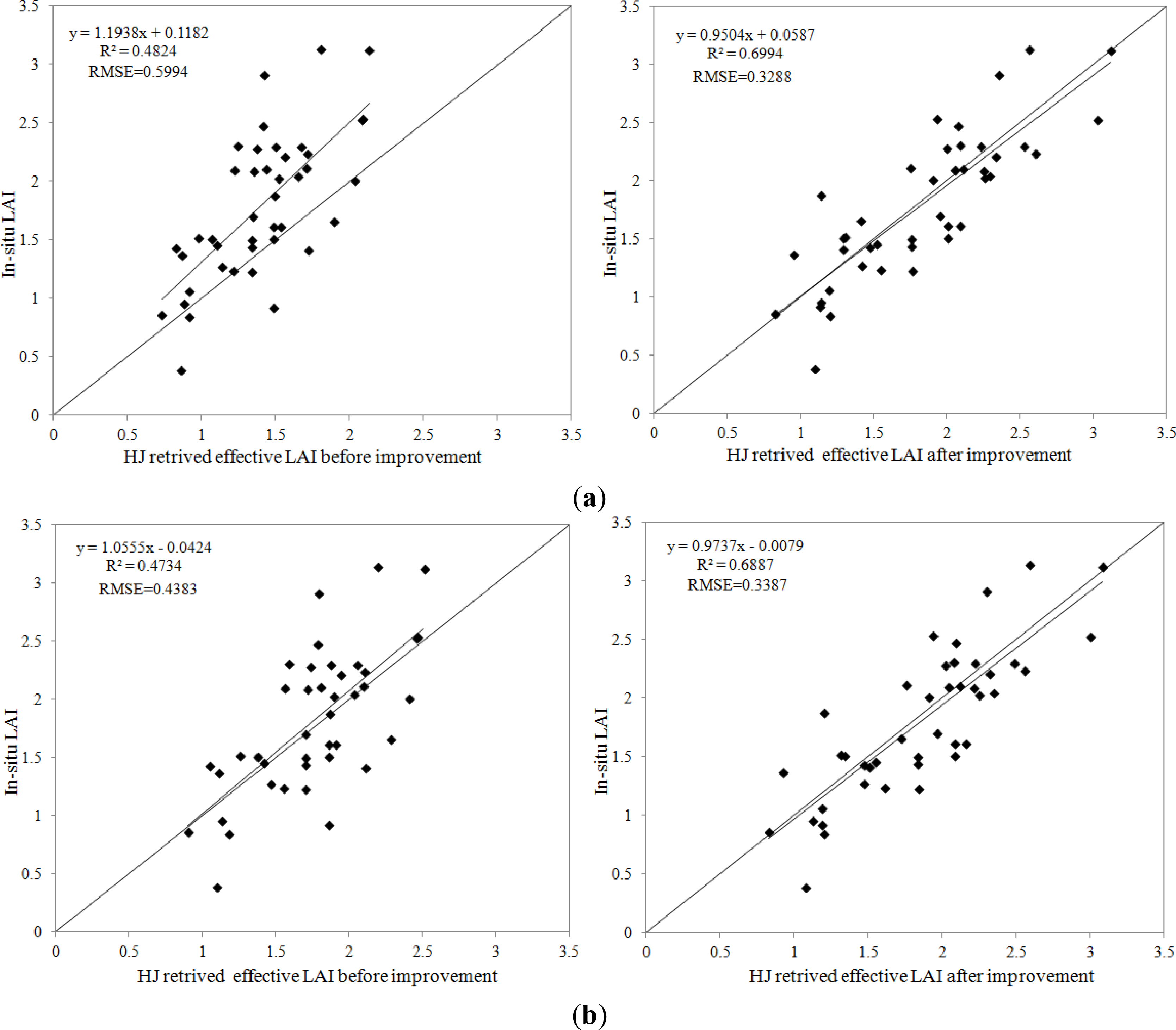
3.4.1. Ground-Based LAI Modeling and 30 m HJ Retrieved LAI Mapping
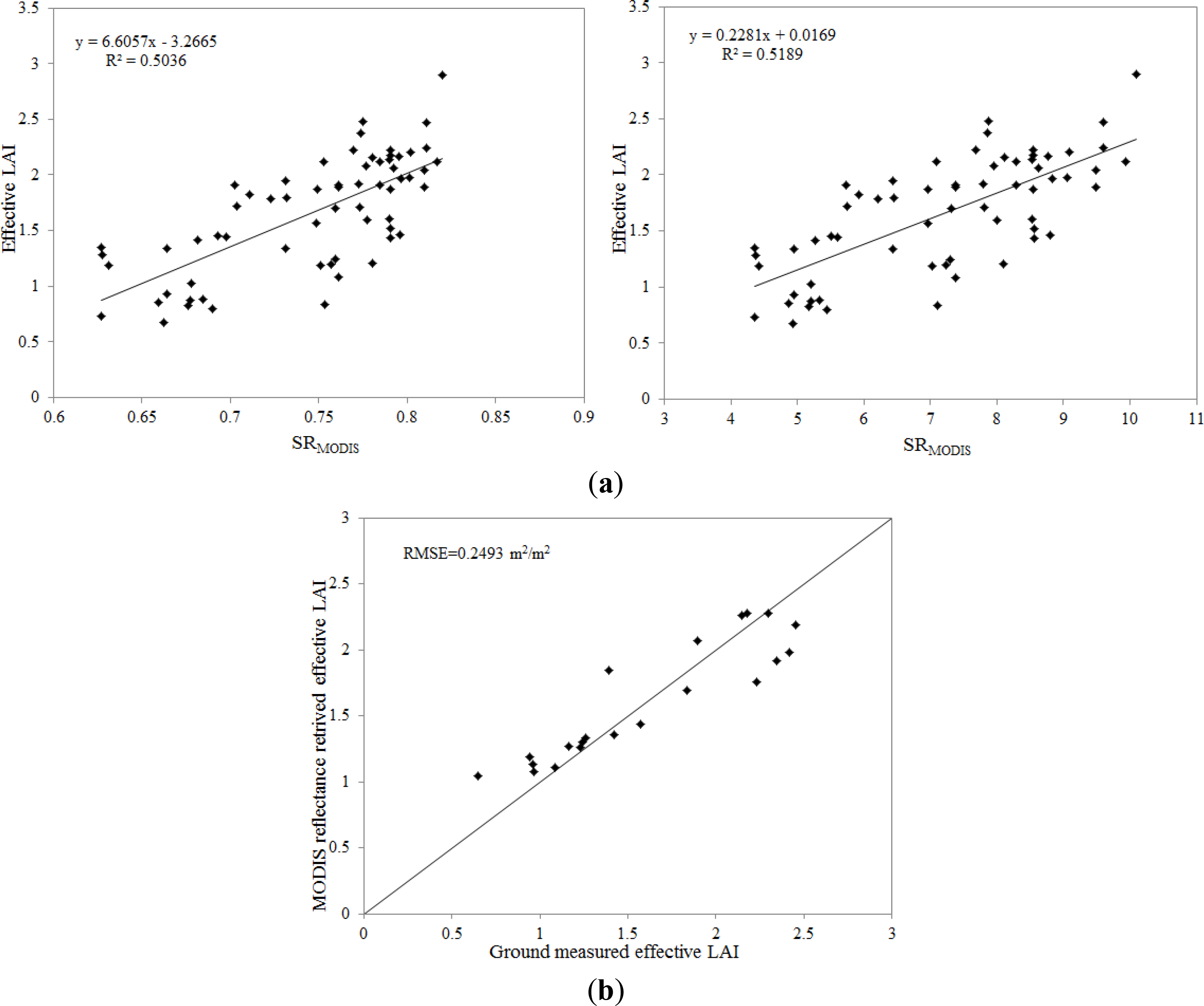
3.4.2. MODIS Surface Reflectance-Based LAI Modeling and 500 m MODIS Retrieved LAI Mapping
4. Results and Discussion
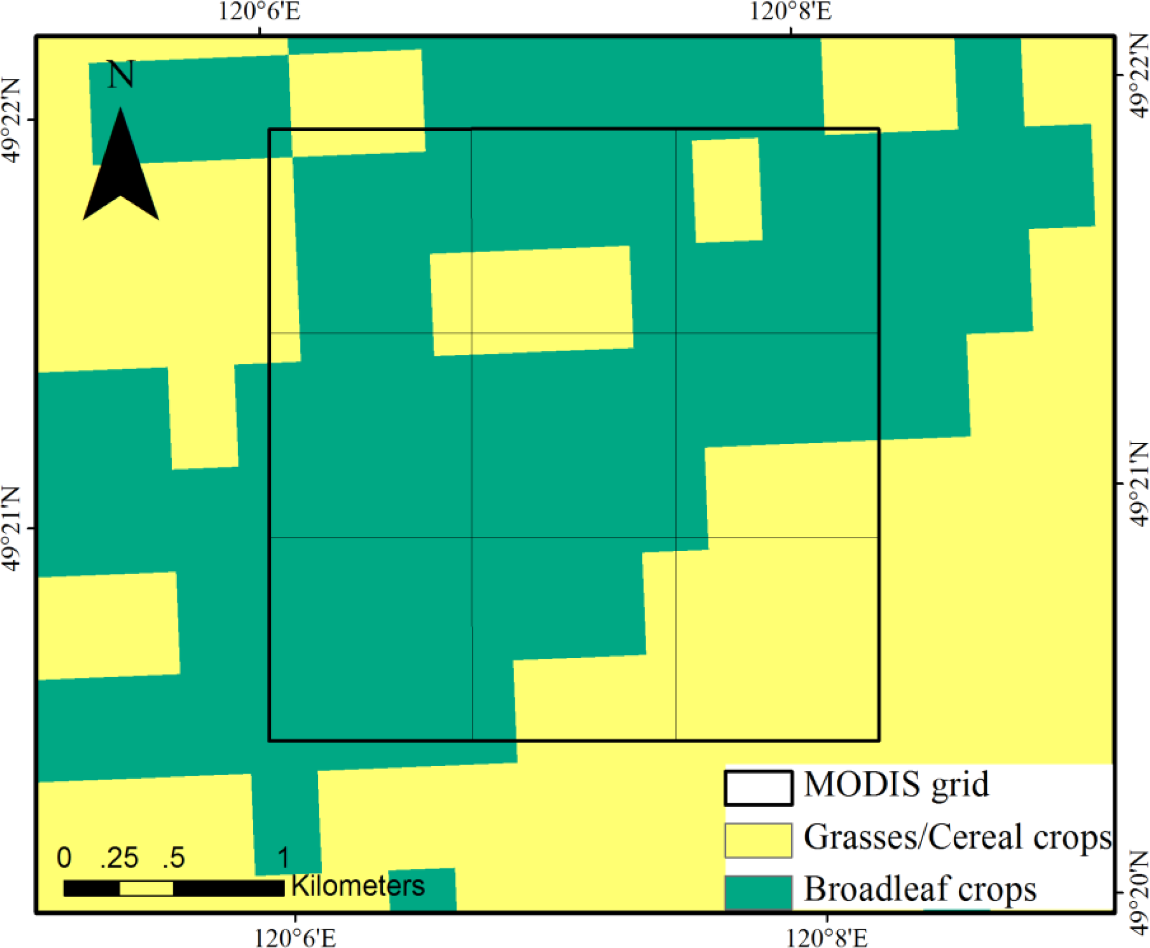
4.1. Land Cover Comparison
4.2. Comparison between HJ Retrieved LAI and the MODIS LAI Product
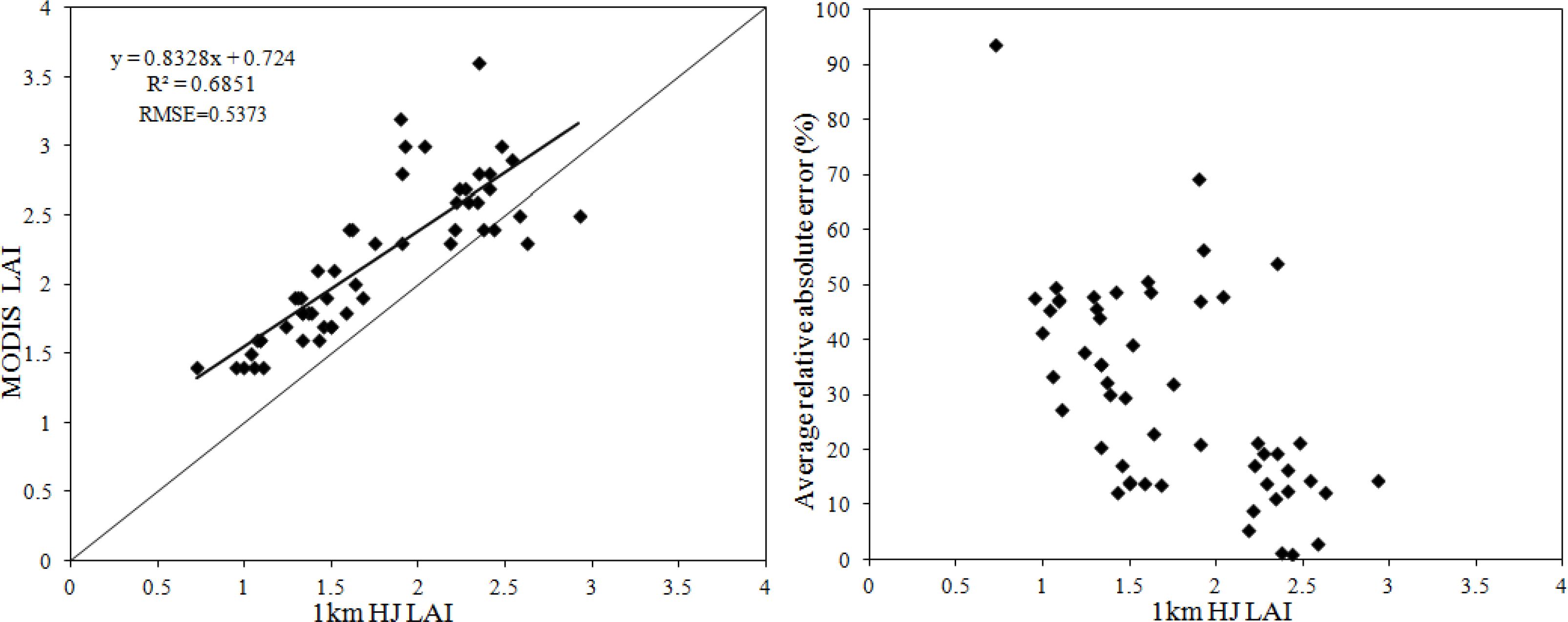
4.2.1. Pixel-by-Pixel Comparison
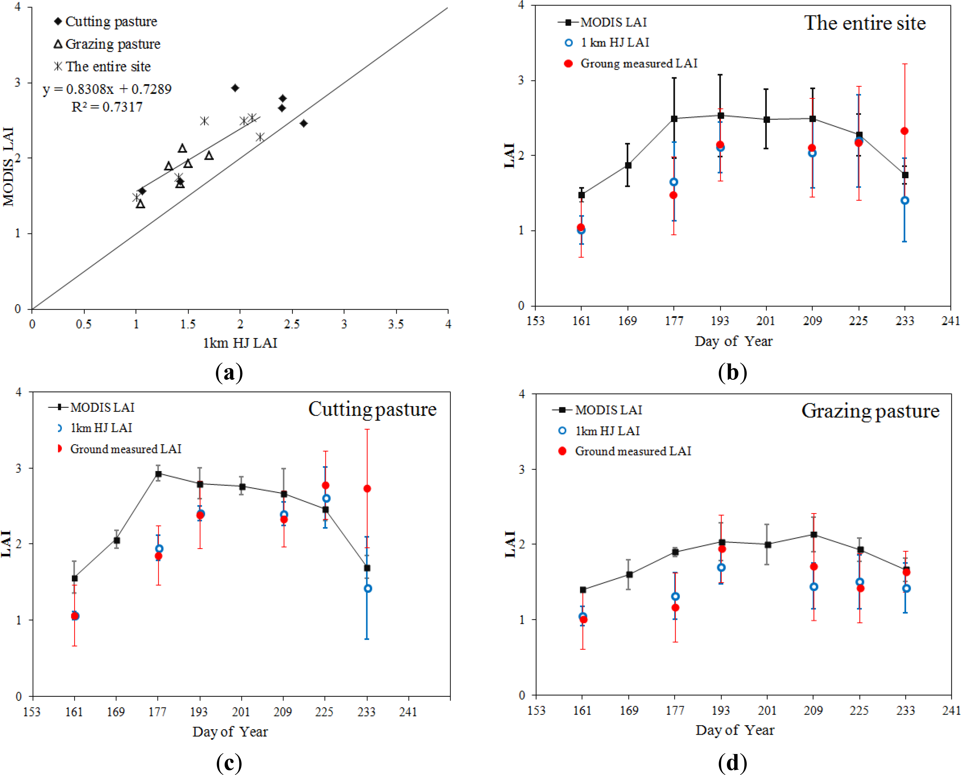
4.2.2. Patch-by-Patch Comparison
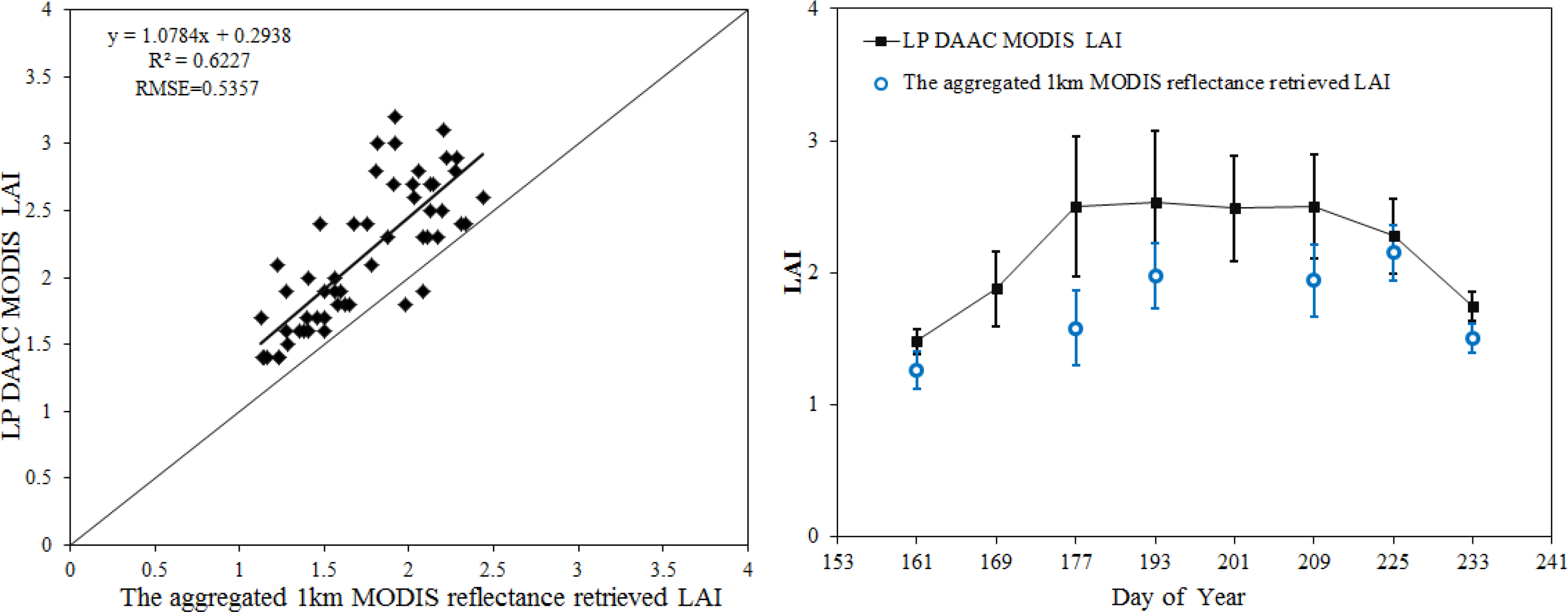
4.3. Comparison between the 500 m MODIS Reflectance Retrieved LAI and the MODIS LAI Product
4.4. Consideration of Sources of Error and Uncertainty
5. Conclusions
Acknowledgments
Author Contributions
Conflicts of Interest
References
- Chen, J.M.; Black, T. Defining leaf area index for non-flat leaves. Plant Cell Environ 1992, 15, 421–429. [Google Scholar]
- Myneni, R.; Hoffman, S.; Knyazikhin, Y.; Privette, J.; Glassy, J.; Tian, Y.; Wang, Y.; Song, X.; Zhang, Y.; Smith, G. Global products of vegetation leaf area and fraction absorbed PAR from year one of MODIS data. Remote Sens. Environ 2002, 83, 214–231. [Google Scholar]
- Running, S.W.; Nemani, R.R.; Peterson, D.L.; Band, L.E.; Potts, D.F.; Pierce, L.L.; Spanner, M.A. Mapping regional forest evapotranspiration and photosynthesis by coupling satellite data with ecosystem simulation. Ecology 1989, 70, 1090–1101. [Google Scholar]
- Sellers, P.; Dickinson, R.; Randall, D.; Betts, A.; Hall, F.; Berry, J.; Collatz, G.; Denning, A.; Mooney, H.; Nobre, C. Modeling the exchanges of energy, water, and carbon between continents and the atmosphere. Science 1997, 275, 502–509. [Google Scholar]
- Bonan, G.B. Land-atmosphere interactions for climate system models: Coupling biophysical, biogeochemical, and ecosystem dynamical processes. Remote Sens. Environ 1995, 51, 57–73. [Google Scholar]
- Foley, J.A.; Levis, S.; Prentice, I.C.; Pollard, D.; Thompson, S.L. Coupling dynamic models of climate and vegetation. Glob. Chang. Biol 1998, 4, 561–579. [Google Scholar]
- Justice, C.O.; Vermote, E.; Townshend, J.R.; Defries, R.; Roy, D.P.; Hall, D.K.; Salomonson, V.V.; Privette, J.L.; Riggs, G.; Strahler, A. The Moderate Resolution Imaging Spectroradiometer (MODIS): Land remote sensing for global change research. IEEE Trans. Geosci. Remote Sens 1998, 36, 1228–1249. [Google Scholar]
- Privette, J.; Asner, G.; Conel, J.; Huemmrich, K.; Olson, R.; Rango, A.; Rahman, A.; Thome, K.; Walter-Shea, E.A. The EOS prototype validation exercise (PROVE) at Jornada: Overview and lessons learned. Remote Sens. Environ 2000, 74, 1–12. [Google Scholar]
- Privette, J.; Myneni, R.; Knyazikhin, Y.; Mukelabai, M.; Roberts, G.; Tian, Y.; Wang, Y.; Leblanc, S. Early spatial and temporal validation of MODIS LAI product in the Southern Africa Kalahari. Remote Sens. Environ 2002, 83, 232–243. [Google Scholar]
- Yang, W.; Tan, B.; Huang, D.; Rautiainen, M.; Shabanov, N.V.; Wang, Y.; Privette, J.L.; Huemmrich, K.F.; Fensholt, R.; Sandholt, I. MODIS leaf area index products: From validation to algorithm improvement. IEEE Trans. Geosci. Remote Sens 2006, 44, 1885–1898. [Google Scholar]
- Morisette, J.T.; Privette, J.L.; Justice, C.O. A framework for the validation of MODIS land products. Remote Sens. Environ 2002, 83, 77–96. [Google Scholar]
- Justice, C.; Belward, A.; Morisette, J.; Lewis, P.; Privette, J.; Baret, F. Developments in the “validation” of satellite sensor products for the study of the land surface. Int. J. Remote Sens 2000, 21, 3383–3390. [Google Scholar]
- Gessner, U.; Niklaus, M.; Kuenzer, C.; Dech, S. Intercomparison of leaf area index products for a gradient of sub-humid to arid environments in West Africa. Remote Sens 2013, 5, 1235–1257. [Google Scholar]
- Linking In Situ Measurements, Remote Sensing, and Models to Validate MODIS Products Related to the Terrestrial Carbon Cycle. Available online: http://www.fsl.orst.edu/larse/bigfoot/index.html (accessed on 18 May 2013).
- Morisette, J.T.; Baret, F.; Privette, J.L.; Myneni, R.B.; Nickeson, J.E.; Garrigues, S.; Shabanov, N.V.; Weiss, M.; Fernandes, R.A.; Leblanc, S.G. Validation of global moderate-resolution LAI products: A framework proposed within the CEOS land product validation subgroup. IEEE Trans. Geosci. Remote Sens 2006, 44, 1804–1817. [Google Scholar]
- Cohen, W.B.; Maiersperger, T.K.; Yang, Z.; Gower, S.T.; Turner, D.P.; Ritts, W.D.; Berterretche, M.; Running, S.W. Comparisons of land cover and LAI estimates derived from ETM+ and MODIS for four sites in North America: A quality assessment of 2000/2001 provisional MODIS products. Remote Sens. Environ 2003, 88, 233–255. [Google Scholar]
- Cohen, W.B.; Maiersperger, T.K.; Turner, D.P.; Ritts, W.D.; Pflugmacher, D.; Kennedy, R.E.; Kirschbaum, A.; Running, S.W.; Costa, M.; Gower, S.T. MODIS land cover and LAI collection 4 product quality across nine sites in the western hemisphere. IEEE Trans. Geosci. Remote Sens 2006, 44, 1843–1857. [Google Scholar]
- VAlidation of Land European Remote Sensing Instruments. Available online: http://w3.avignon.inra.fr/valeri/ (accessed on 18 May 2013).
- VALERI: A Network of Sites and a Methodology for the Validation of Medium Spatial Resolution Land Satellite Products. Available online: http://w3.avignon.inra.fr/valeri/documents/VALERI-RSESubmitted.pdf (accessed on 18 May 2013).
- CEOS Committee on Earth Observation Satellites. Available online: http://www.ceos.org/ (accessed on 18 May 2013).
- De Kauwe, M.; Disney, M.; Quaife, T.; Lewis, P.; Williams, M. An assessment of the MODIS collection 5 leaf area index product for a region of mixed coniferous forest. Remote Sens. Environ 2011, 115, 767–780. [Google Scholar]
- Tan, B.; Hu, J.; Huang, D.; Yang, W.; Zhang, P.; Shabanov, N.V.; Knyazikhin, Y.; Nemani, R.R.; Myneni, R.B. Assessment of the broadleaf crops leaf area index product from the Terra MODIS instrument. Agric. For. Meteorol 2005, 135, 124–134. [Google Scholar]
- Shabanov, N.; Samata, A.; Myneni, R.; Knyazikhin, Y.; Votava, P. Collection 5 MODIS LAI and FPAR Products; MODIS STM, University of Maryland: College Park, MD, USA, 2007. [Google Scholar]
- Friedl, M.A.; Sulla-Menashe, D.; Tan, B.; Schneider, A.; Ramankutty, N.; Sibley, A.; Huang, X. MODIS collection 5 global land cover: Algorithm refinements and characterization of new datasets. Remote Sens. Environ 2010, 114, 168–182. [Google Scholar]
- Chen, J.M.; Pavlic, G.; Brown, L.; Cihlar, J.; Leblanc, S.; White, H.; Hall, R.; Peddle, D.; King, D.; Trofymow, J. Derivation and validation of Canada-wide coarse-resolution leaf area index maps using high-resolution satellite imagery and ground measurements. Remote Sens. Environ 2002, 80, 165–184. [Google Scholar]
- Tian, Y.; Woodcock, C.E.; Wang, Y.; Privette, J.L.; Shabanov, N.V.; Zhou, L.; Zhang, Y.; Buermann, W.; Dong, J.; Veikkanen, B. Multiscale analysis and validation of the MODIS LAI product: II. Sampling strategy. Remote Sens. Environ 2002, 83, 431–441. [Google Scholar]
- Weiss, M.; de Beaufort, L.; Baret, F.; Allard, D.; Bruguier, N.; Marloie, O. Mapping Leaf Area Index Measurements at Different Scales for the Validation of Large Swath Satellite Sensors: First Results of the VALERI Project. In Proceedings of the 8th International Symposium on Physical Measurements and Signatures in Remote Sensing, Aussois, France; 2001; pp. 125–130. [Google Scholar]
- Wang, Y.; Woodcock, C.E.; Buermann, W.; Stenberg, P.; Voipio, P.; Smolander, H.; Häme, T.; Tian, Y.; Hu, J.; Knyazikhin, Y. Evaluation of the MODIS LAI algorithm at a coniferous forest site in Finland. Remote Sens. Environ 2004, 91, 114–127. [Google Scholar]
- Tian, Y.; Woodcock, C.E.; Wang, Y.; Privette, J.L.; Shabanov, N.V.; Zhou, L.; Zhang, Y.; Buermann, W.; Dong, J.; Veikkanen, B. Multiscale analysis and validation of the MODIS LAI product: I. Uncertainty assessment. Remote Sens. Environ 2002, 83, 414–430. [Google Scholar]
- Wu, H.; Li, Z.-L. Scale issues in remote sensing: A review on analysis, processing and modeling. Sensors 2009, 9, 1768–1793. [Google Scholar]
- Ma, M.; Li, X.; Wang, W.; Xiao, Q.; Zhao, K.; Xin, X. Design on Validation Network of Remote Sensing Products in China. In Proceedings of the 8th International Symposium on Spatial Data Quality, Hong Kong, China, 30 May–1 June 2013; XL-2/W1.
- Yan, Y.; Xin, X.; Xu, X.; Wang, X.; Yang, G.; Yan, R.; Chen, B. Quantitative effects of wind erosion on the soil texture and soil nutrients under different vegetation coverage in a semiarid steppe of northern China. Plant Soil 2013, 369, 585–598. [Google Scholar]
- Welles, J.M.; Norman, J.M. Instrument for indirect measurement of canopy architecture. Agron. J 1991, 83, 818–825. [Google Scholar]
- Huemmrich, K.F.; Privette, J.L.; Mukelabai, M.; Myneni, R.B.; Knyazikhin, Y. Time-series validation of MODIS land biophysical products in a Kalahari woodland, Africa. Int. J. Remote Sens 2005, 26, 4381–4398. [Google Scholar]
- Chen, J.M.; Cihlar, J. Retrieving leaf area index of boreal conifer forests using Landsat TM images. Remote Sens. Environ 1996, 55, 153–162. [Google Scholar]
- Knyazikhin, Y.; Glassy, J.; Privette, J.; Tian, Y.; Lotsch, A.; Zhang, Y.; Wang, Y.; Morisette, J.; Votava, P.; Myneni, R. MODIS Leaf Area Index (LAI) and Fraction of Photosynthetically Active Radiation Absorbed by Vegetation (FPAR) Product (MOD15); Algorithm Theoretical Basis Document; NASA Goddard Space Flight Center: Greenbelt, MD, USA, 1999. [Google Scholar]
- Liu, R.; Chen, J.M.; Liu, J.; Deng, F.; Sun, R. Application of a new leaf area index algorithm to China’s landmass using MODIS data for carbon cycle research. J. Environ. Manag 2007, 85, 649–658. [Google Scholar]
- China Centre for Resources Satellite Data and Application. Available online: http://www.cresda.com/n16/n92006/index.html (accessed on 18 May 2013).
- Wang, Q.; Wu, C.; Li, Q.; Li, J. Chinese HJ-1A/B satellites and data characteristics. Sci. China Earth Sci 2010, 53, 51–57. [Google Scholar]
- Sun, L.; Sun, C.; Liu, Q.; Zhong, B. Aerosol optical depth retrieval by HJ-1/CCD supported by MODIS surface reflectance data. Sci. China Earth Sci 2010, 53, 74–80. [Google Scholar]
- Agrawal, G.; Bhopal, M.; Sarup, J. Comparision of QUAC and FLASSH atmospheric correction modules on EO-1 hyperion data of Sanchi. Int. J. Adv. Eng. Sci. Technol 2011, 4, 178–186. [Google Scholar]
- He, L.; Wang, H.; Yan, G.; Li, X.; Zhu, W.; Wang, J. Analysis and application for the empirical relative between aerosol optical depth and horizontal meteorological range. J. Remote Sens 2003, 7, 372–378. (In Chinese) [Google Scholar]
- LP DAAC: NASA Land Data Products and Servaces. Available online: https://lpdaac.usgs.gov/ (accessed on 18 May 2013).
- Myneni, R.; Knyazikhin, Y.; Glassy, J.; Votava, P.; Shabanov, N. User’s Guide: FPAR, LAI (ESDT: MOD15A2) 8-Day Composite NASA MODIS Land Algorithm; Boston University: Boston, MA, USA, 2003. [Google Scholar]
- Pisek, J.; Chen, J.M. Comparison and validation of MODIS and VEGETATION global LAI products over four BigFoot sites in North America. Remote Sens. Environ 2007, 109, 81–94. [Google Scholar]
- Wang, Y.; Tian, Y.; Zhang, Y.; El-Saleous, N.; Knyazikhin, Y.; Vermote, E.; Myneni, R.B. Investigation of product accuracy as a function of input and model uncertainties: Case study with SEAWiFS and MODIS LAI/FPAR algorithm. Remote Sens. Environ 2001, 78, 299–313. [Google Scholar]
- Tan, B.; Hu, J.; Zhang, P.; Huang, D.; Shabanov, N.; Weiss, M.; Knyazikhin, Y.; Myneni, R.B. Validation of Moderate Resolution Imaging Spectroradiometer leaf area index product in croplands of Alpilles, France. J. Geophys. Res 2005, 110. [Google Scholar] [CrossRef]
- Knyazikhin, Y.; Martonchik, J.; Diner, D.; Myneni, R.; Verstraete, M.; Pinty, B.; Gobron, N. Estimation of vegetation canopy leaf area index and fraction of absorbed photosynthetically active radiation from atmosphere-corrected MISR data. J. Geophys. Res 1998, 103, 32239–32256. [Google Scholar]
- Tian, Y.; Zhang, Y.; Knyazikhin, Y.; Myneni, R.B.; Glassy, J.M.; Dedieu, G.; Running, S.W. Prototyping of MODIS LAI and FPAR algorithm with LASUR and LANDSAT data. IEEE Trans. Geosci. Remote Sens 2000, 38, 2387–2401. [Google Scholar]
- Fensholt, R.; Sandholt, I.; Rasmussen, M.S. Evaluation of MODIS LAI, fAPAR and the relation between fAPAR and NDVI in a semi-arid environment using in situ measurements. Remote Sens. Environ 2004, 91, 490–507. [Google Scholar]
- Yang, W.; Shabanov, N.; Huang, D.; Wang, W.; Dickinson, R.; Nemani, R.; Knyazikhin, Y.; Myneni, R. Analysis of leaf area index products from combination of MODIS Terra and Aqua data. Remote Sens. Environ 2006, 104, 297–312. [Google Scholar]
- Knyazikhin, Y.; Martonchik, J.V.; Myneni, R.B.; Diner, D.J.; Running, S.W. Synergistic algorithm for estimating vegetation canopy leaf area index and fraction of absorbed photosynthetically active radiation from MODIS and MISR data. J. Geophys. Res 1998, 103, 32257–32275. [Google Scholar]
- Jin, Z.; Tian, Q.; Chen, J.M.; Chen, M. Spatial scaling between leaf area index maps of different resolutions. J. Environ. Manag 2007, 85, 628–637. [Google Scholar]
- Jensen, J.L.R.; Humes, K.S.; Hudak, A.T.; Vierling, L.A.; Delmelle, E. Evaluation of the MODIS LAI product using independent lidar-derived LAI: A case study in mixed conifer forest. Remote Sens. Environ 2011, 115, 3625–3639. [Google Scholar]
- Eriksson, H.M.; Eklundh, L.; Kuusk, A.; Nilson, T. Impact of understory vegetation on forest canopy reflectance and remotely sensed LAI estimates. Remote Sens. Environ 2006, 103, 408–418. [Google Scholar]
- Steinberg, D.C.; Goetz, S.J.; Hyer, E.J. Validation of MODIS F/sub PAR/products in boreal forests of Alaska. IEEE Trans. Geosci. Remote Sens 2006, 44, 1818–1828. [Google Scholar]
- Chasmer, L.; Hopkinson, C.; Treitz, P.; McCaughey, H.; Barr, A.; Black, A. A lidar-based hierarchical approach for assessing MODIS fPAR. Remote Sens. Environ 2008, 112, 4344–4357. [Google Scholar]
- Serbin, G.; Daughtry, C.S.; Hunt, E.R., Jr.; McCarty, G.W.; Doraiswamy, P.C. Remote Sensing of Crop Residue and Non-Photosynthetic Vegetation. In Proceedings of the 2008 NASA Carbon Cycle and Ecosystems Joint Science Workshop, Adelphi, MD, USA, 28 April–2 May 2008; pp. 222–224.
- Ren, H.; Zhou, G. Estimating senesced biomass of desert steppe in Inner Mongolia using field spectrometric data. Agric. For. Meteorol 2012, 161, 66–71. [Google Scholar]
- Guan, H.; Xie, H.; Zhu, M. Canopy blockage and scattering effects on apparent soil spectral reflectance and its consequence in spectral mixture analysis of vegetated surfaces. Int. J. Remote Sens 2008, 29, 3509–3522. [Google Scholar]
- Powell, R.L.; Roberts, D.A.; Dennison, P.E.; Hess, L.L. Sub-pixel mapping of urban land cover using multiple endmember spectral mixture analysis: Manaus Brazil. Remote Sens. Environ 2007, 106, 253–267. [Google Scholar]
- Lu, D.; Weng, Q. Spectral mixture analysis of the urban landscape in Indianapolis with Landsat ETM+ imagery. Photogramm. Eng. Remote Sens 2004, 70, 1053–1062. [Google Scholar]
- Somers, B.; Asner, G.P.; Tits, L.; Coppin, P. Endmember variability in spectral mixture analysis: A review. Remote Sens. Environ 2011, 115, 1603–1616. [Google Scholar]
- Guerschman, J.P.; Hill, M.J.; Renzullo, L.J.; Barrett, D.J.; Marks, A.S.; Botha, E.J. Estimating fractional cover of photosynthetic vegetation, non-photosynthetic vegetation and bare soil in the australian tropical savanna region upscaling the EO-1 hyperion and MODIS sensors. Remote Sens. Environ 2009, 113, 928–945. [Google Scholar]
- Dong, H.; Wenze, Y.; Tan, B.; Rautiainen, M.; Ping, Z.; Jiannan, H.; Shabanov, N.V.; Linder, S.; Knyazikhin, Y.; Myneni, R.B. The importance of measurement errors for deriving accurate reference leaf area index maps for validation of moderate-resolution satellite LAI products. IEEE Trans. Geosci. Remote Sens 2006, 44, 1866–1871. [Google Scholar]
- Mu, X.; Shen, Q.; Li, Z.-L.; Yan, G.; Sobrino, J.A. A comparison of different optimization algorithms for retrieving aerosol optical depths from satellite data: An example of using a dual-angle algorithm. Int. J. Remote Sens 2011, 32, 8949–8968. [Google Scholar]
- Wu, H.; Tang, B.-H.; Li, C.; Li, Z.-L. Leaf Area Index Retrieval from Remotely Sensed Data: Scaling Effect and Propagation Mechanisms. In Proceedings of the 2010 IEEE International Geoscience and Remote Sensing Symposium (IGARSS), Honolulu, HI, USA, 25–30 July 2010; pp. 2668–2671.
- Wu, H.; Tang, B.-H.; Li, Z.-L. Impact of nonlinearity and discontinuity on the spatial scaling effects of the leaf area index retrieved from remotely sensed data. Int. J. Remote Sens 2013, 34, 3503–3519. [Google Scholar]
- Chen, J.M.; Dend, F.; Chen, M. Locally adjusted cubic-spline capping for reconstructing seasonal trajectories of a satellite-derived surface parameter. IEEE Trans. Geosci. Remote Sens 2006, 44, 2230–2238. [Google Scholar]

| Experiment Date | Sensor for Acquired HJ Images | HJ Image Date | MODIS LAI Composition Time-Interval |
|---|---|---|---|
| 4–5 June | HJ1B-CCD1 | 4 June 2013 | 153–161 (2–10 June) |
| 21–23 June | HJ1B-CCD1 | 23 June 2013 | 169–171 (18–26 June) |
| 6–7 July | HJ1A-CCD1 | 6 July 2013 | 177–185 (26 June–4 July) |
| 13–14 July | HJ1A-CCD2 | 13 July 2013 | 185–193 (4–12 July) |
| 25–26 July | HJ1A-CCD2 | 21 July 2013 | 201–209 (20–28 July) |
| 11–12 August | HJ1B-CCD2 | 11 August 2013 | 217–225 (5–13 August) |
| 19–20 August | HJ1B-CCD2 | 19 August 2013 | 225–233 (13–21 August) |
| Date | VI | Model Improvement | RMSE of Model Validation | |||||
|---|---|---|---|---|---|---|---|---|
| n | Relationship | R2 | RMSE | n | Before | After | ||
| 4 June | NDVI | 10 | LAIaft = 0.9521 × LAIbef + 0.1300 | 0.7728 | 0.097 | 6 | 0.3369 | 0.3285 |
| SR | LAIaft = 0.6437 × LAIbef + 0.2455 | 0.7565 | 0.145 | 0.3635 | 0.3290 | |||
| 23 June | NDVI | 12 | LAIaft = 0.6820 × LAIbef + 0.1157 | 0.5558 | 0.38 | 6 | 0.3140 | 0.3744 |
| SR | LAIaft = 1.2773 × LAIbef − 1.1868 | 0.5091 | 0.73 | 0.5611 | 0.3827 | |||
| 6 July | NDVI | 10 | LAIaft = 0.4912 × LAIbef + 0.9038 | 0.7077 | 0.3 | 6 | 0.3938 | 0.3901 |
| SR | LAIaft = 0.4844 × LAIbef + 0.7424 | 0.7019 | 0.45 | 0.3906 | 0.3861 | |||
| 13 July | NDVI | 10 | LAIaft = 1.4786 × LAIbef + 0.2480 | 0.6307 | 0.76 | 6 | 0.7646 | 0.2935 |
| SR | LAIaft = 1.1136 × LAIbef + 0.3033 | 0.6193 | 0.48 | 0.4941 | 0.2754 | |||
| 25 July | NDVI | 13 | LAIaft = 1.7577 × LAIbef − 0.4161 | 0.6574 | 0.64 | 6 | 0.6122 | 0.2672 |
| SR | LAIaft = 1.4704 × LAIbef − 0.5354 | 0.6578 | 0.42 | 0.3235 | 0.2251 | |||
| 11 August | NDVI | 12 | LAIaft = 2.7826 × LAIbef − 1.8614 | 0.7673 | 0.76 | 6 | 0.6092 | 0.3613 |
| SR | LAIaft = 2.5092 × LAIbef − 2.3680 | 0.7764 | 0.54 | 0.4289 | 0.3594 | |||
| 19 August | NDVI | 13 | LAIaft = 1.7141 × LAIbef − 0.5404 | 0.6299 | 0.69 | 6 | 0.6300 | 0.4228 |
| SR | LAIaft = 1.5418 × LAIbef − 0.7854 | 0.6518 | 0.63 | 0.4763 | 0.4508 | |||
| Patch | Mean LAI Value (m2/m2) | 4 June (161) | 23 June (177) | 13 July (193) | 25 July (209) | 11 August (225) | 19 August (233) | Average Relative Error | R2 | RMSE (m2/m2) |
|---|---|---|---|---|---|---|---|---|---|---|
| The entire site | 1 km HJ | 1.01 | 1.66 | 2.11 | 2.04 | 2.20 | 1.41 | |||
| MODIS | 1.48 | 2.50 | 2.53 | 2.50 | 2.28 | 1.74 | ||||
| relative error | 46.53 | 50.60 | 19.91 | 22.55 | 3.64 | 23.40 | 27.77 | 0.86 | 0.49 | |
| Cutting pasture | 1 km HJ | 1.06 | 1.95 | 2.41 | 2.40 | 2.61 | 1.42 | |||
| MODIS | 1.57 | 2.93 | 2.80 | 2.67 | 2.47 | 1.70 | ||||
| relative error | 48.11 | 50.26 | 16.18 | 11.25 | −5.36 | 19.72 | 23.36 | 0.81 | 0.51 | |
| Grazing pasture | 1 km HJ | 1.05 | 1.32 | 1.70 | 1.45 | 1.51 | 1.42 | |||
| MODIS | 1.40 | 1.90 | 2.03 | 2.13 | 1.93 | 1.67 | ||||
| relative error | 33.33 | 43.94 | 19.41 | 46.90 | 27.81 | 17.61 | 31.50 | 0.78 | 0.46 | |
© 2014 by the authors; licensee MDPI, Basel, Switzerland This article is an open access article distributed under the terms and conditions of the Creative Commons Attribution license (http://creativecommons.org/licenses/by/3.0/).
Share and Cite
Li, Z.; Tang, H.; Xin, X.; Zhang, B.; Wang, D. Assessment of the MODIS LAI Product Using Ground Measurement Data and HJ-1A/1B Imagery in the Meadow Steppe of Hulunber, China. Remote Sens. 2014, 6, 6242-6265. https://doi.org/10.3390/rs6076242
Li Z, Tang H, Xin X, Zhang B, Wang D. Assessment of the MODIS LAI Product Using Ground Measurement Data and HJ-1A/1B Imagery in the Meadow Steppe of Hulunber, China. Remote Sensing. 2014; 6(7):6242-6265. https://doi.org/10.3390/rs6076242
Chicago/Turabian StyleLi, Zhenwang, Huan Tang, Xiaoping Xin, Baohui Zhang, and Dongliang Wang. 2014. "Assessment of the MODIS LAI Product Using Ground Measurement Data and HJ-1A/1B Imagery in the Meadow Steppe of Hulunber, China" Remote Sensing 6, no. 7: 6242-6265. https://doi.org/10.3390/rs6076242
APA StyleLi, Z., Tang, H., Xin, X., Zhang, B., & Wang, D. (2014). Assessment of the MODIS LAI Product Using Ground Measurement Data and HJ-1A/1B Imagery in the Meadow Steppe of Hulunber, China. Remote Sensing, 6(7), 6242-6265. https://doi.org/10.3390/rs6076242