Geothermal Resource Exploration Using Multi-Temporal Infrared Remote Sensing Data Based on Annual Temperature Variation Model

Highlights
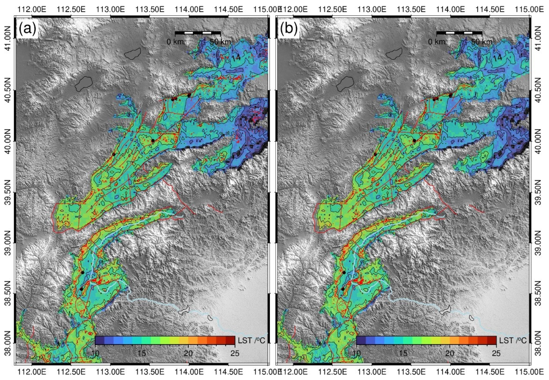
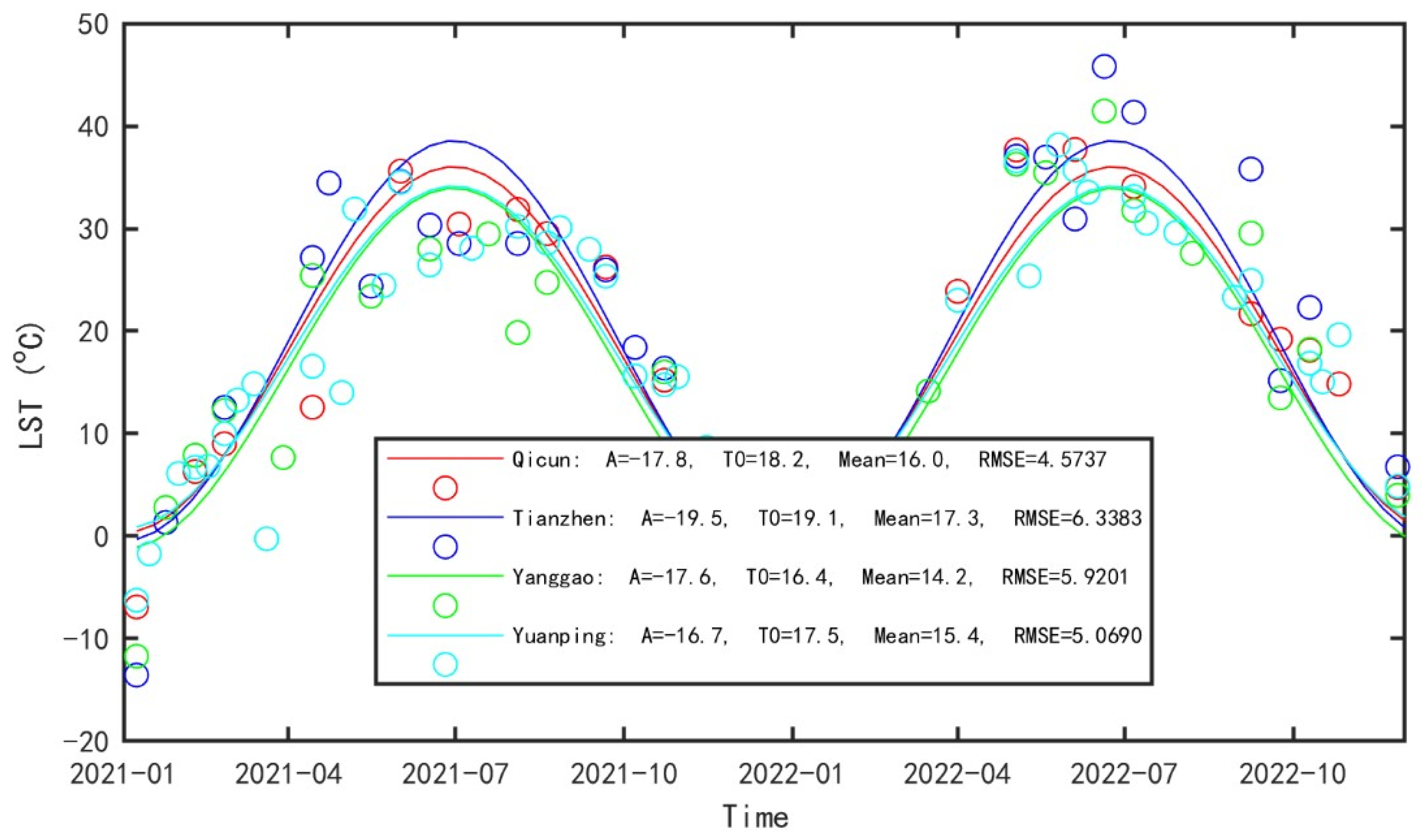
- Nonlinear annual temperature variation fitting applied to ~50 Landsat 8 LST scenes (2021–2022) extracts background temperature T0 and amplitude A anomalies that reveal 1–2 °C offsets and ~2 K amplitude deficits near Tianzhen and Yanggao geothermal fields.
- Elevation/aspect corrections combined with sliding-window deviation, planar gradients, and 5 km fault buffers suppress pseudo anomalies and delineate structural geothermal targets across the Shanxi Graben System.
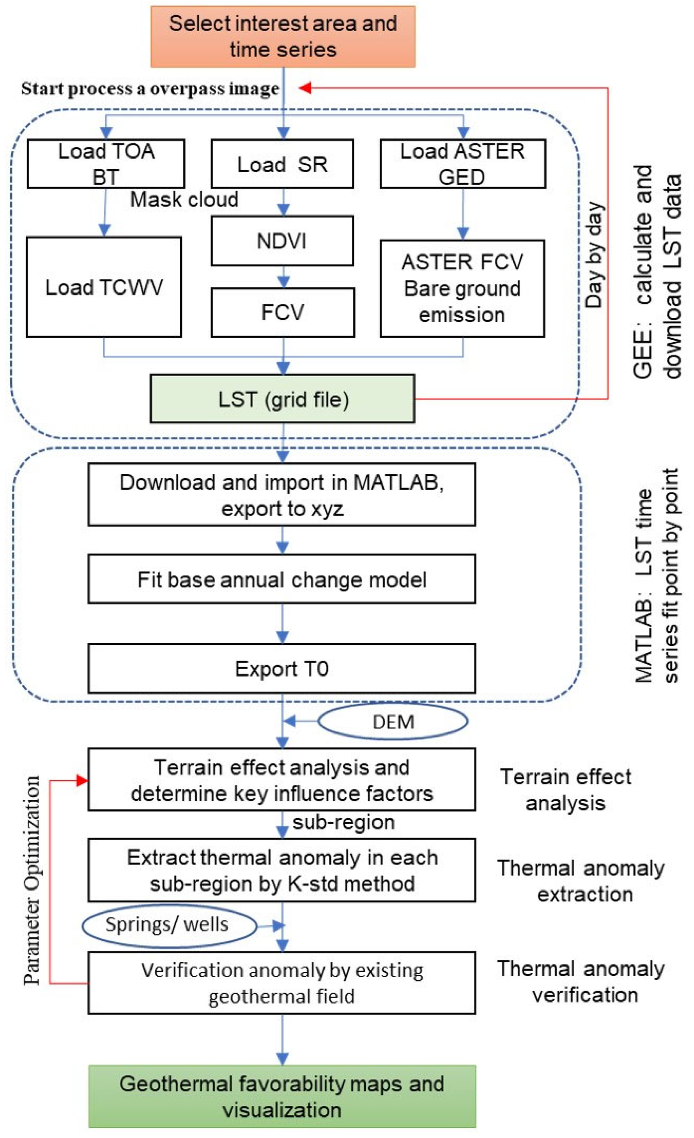
- Workflow leverages Google Earth Engine processing so that the reconnaissance can be reproduced cost-effectively for shallow-to-moderate geothermal systems in other extensional basins.
- Physics-based time-series modeling complements geophysical surveys and prioritizes drilling along structurally controlled corridors where thermal anomalies persist.
Abstract
1. Introduction
2. Methodology and Materials
2.1. Data Acquisition
2.2. Land Surface Temperature Calculation
2.3. Temperature Data Processing and Fitting
2.4. Uncertainty Analysis
2.5. Thermal Anomaly Indicators and Extraction
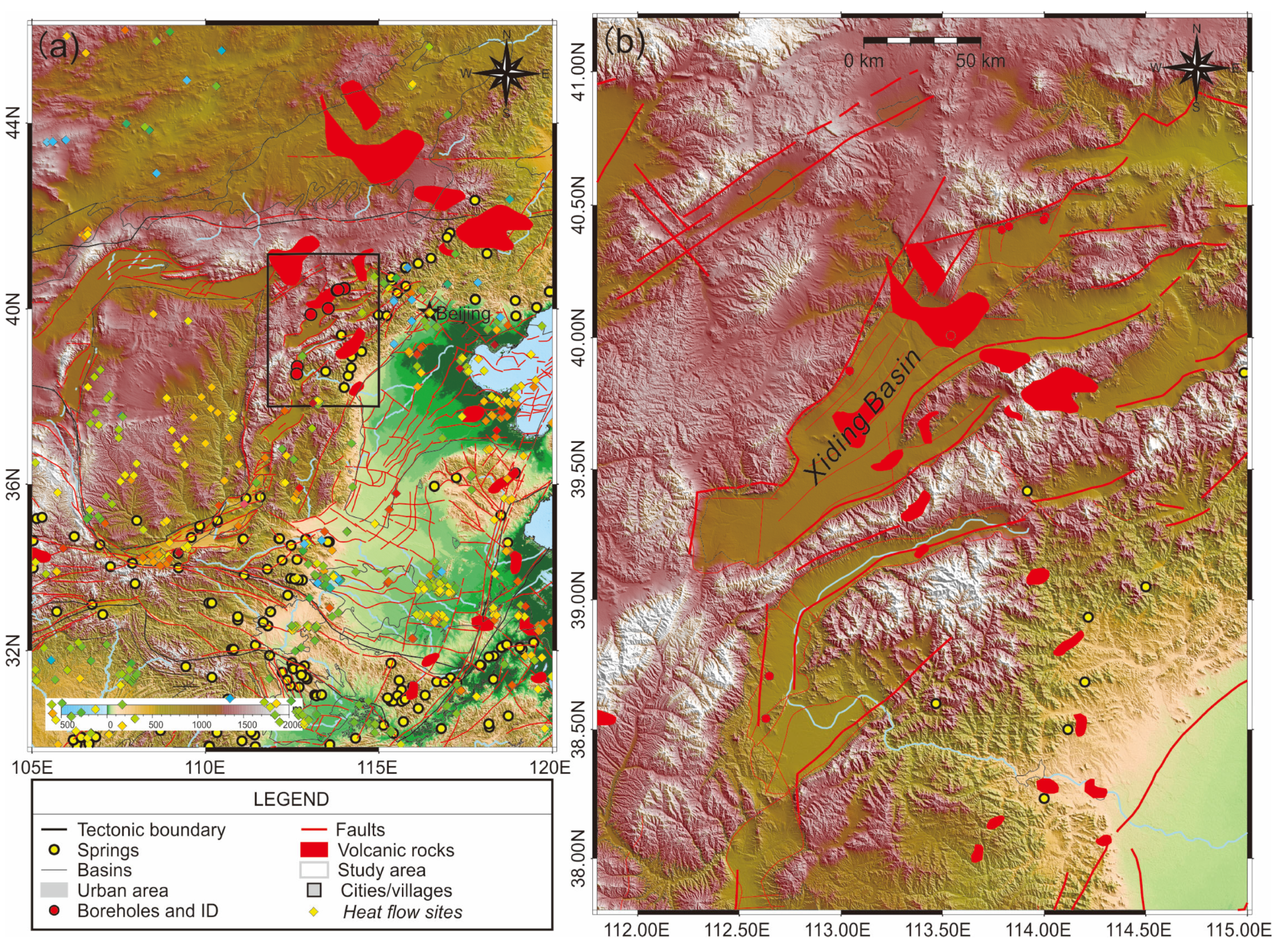
3. Geological Background
4. Results and Discussion
4.1. LST Time Series
4.2. Topographic Effects on LST
4.3. Known Geothermal Areas and Surrounding Temperature Time Series
4.4. Thermal Anomaly Indicators and Extraction—Elevation Correction and Aspect-Based Sub-Regional Extraction
5. Discussion
5.1. Local Optimum Issues
5.2. Uncertainty and Validation
5.3. Comparison with Alternative Approaches
5.4. Detection Depth and Signal Attenuation
5.5. Limitations and Uncertainty Sources
5.6. Future Research Directions
6. Conclusions
- Method Development: We successfully implemented a nonlinear least-squares fitting approach (Levenberg–Marquardt algorithm) to extract background temperature (T0) and amplitude (A) parameters from irregular, cloud-affected Landsat 8 LST time series. The model-fitted T0 values are systematically ~2 °C higher than simple arithmetic means, reflecting more representative temperatures by accounting for seasonal sampling bias (reduced winter observations due to less cloud cover).
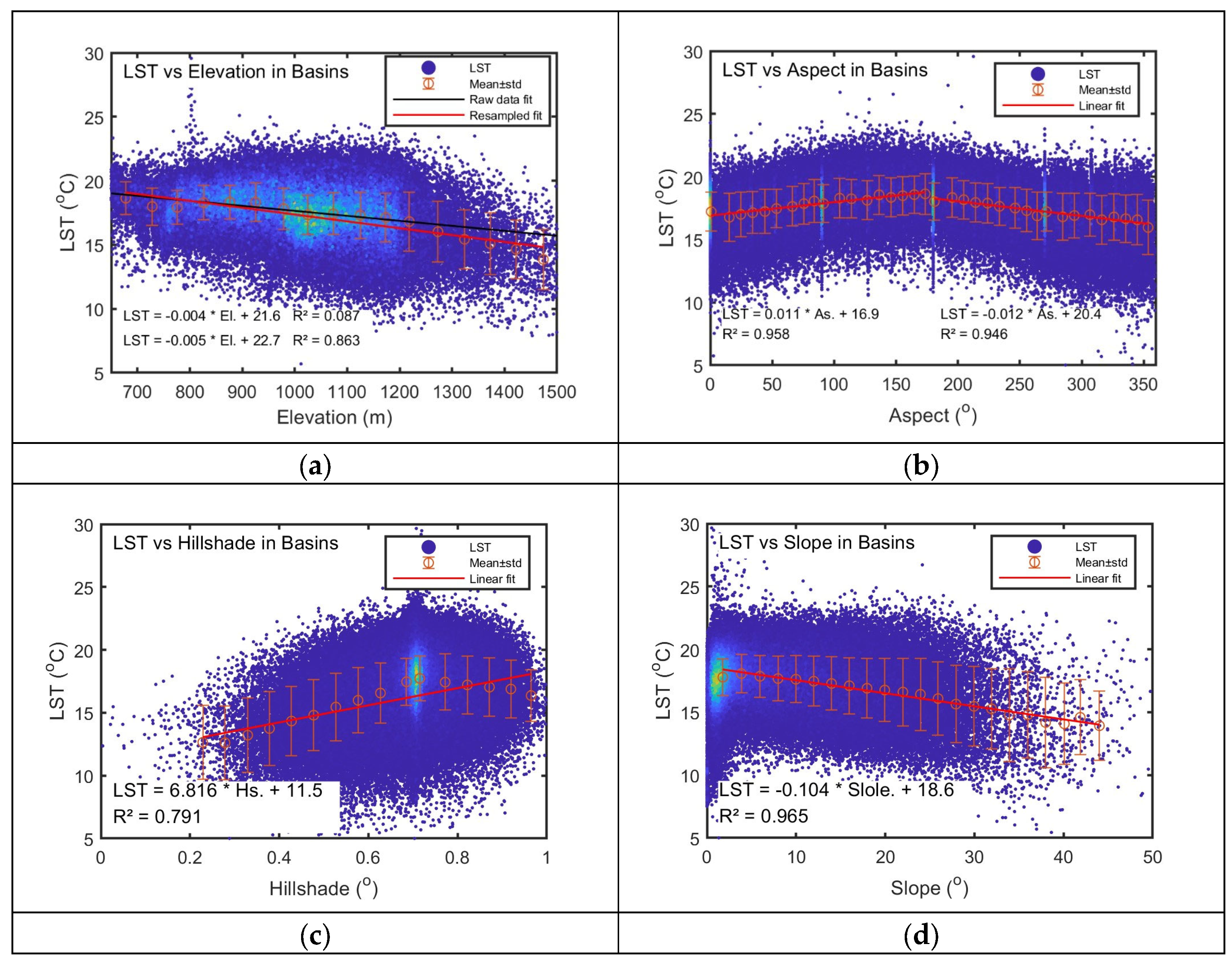
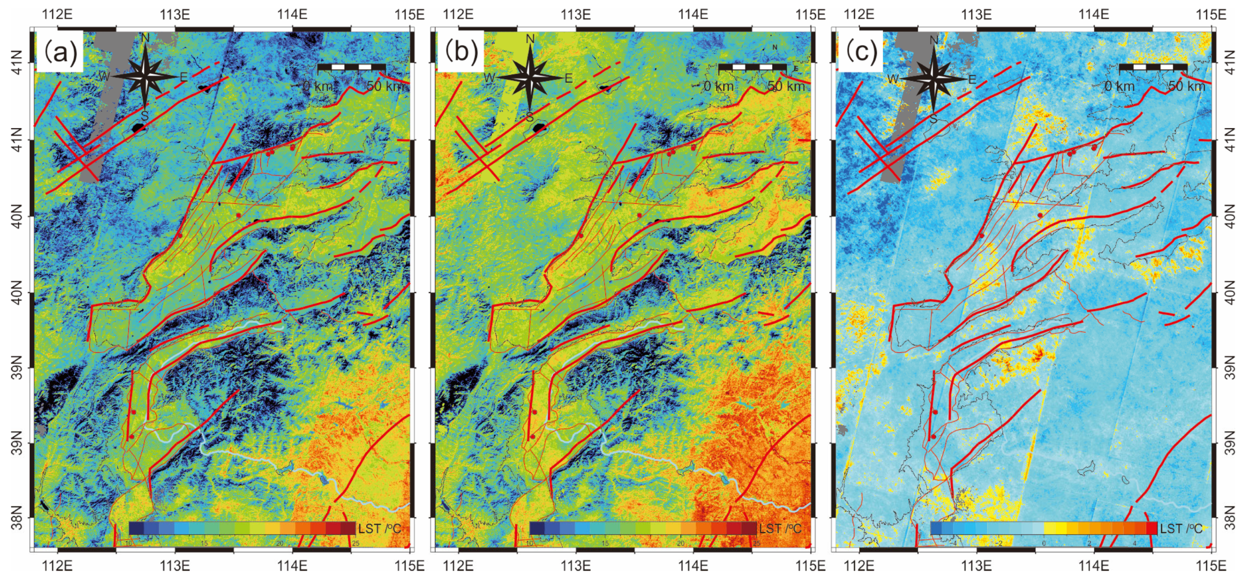
- Topographic Effects: A systematic analysis reveals strong topographic controls based on LST within basin areas (<1200 m elevation): elevation shows −4 °C/100 m gradient above a 800 m elevation; the aspect exhibits tight piecewise linear relationships (R2 > 0.95) with opposite trends in 0–165° and 165–360° ranges; the slope and hillshade show weaker, non-independent effects. These results emphasize the critical importance of topographic correction, consistent with recent studies showing 36–45% pseudo-anomaly reduction after proper correction [18].
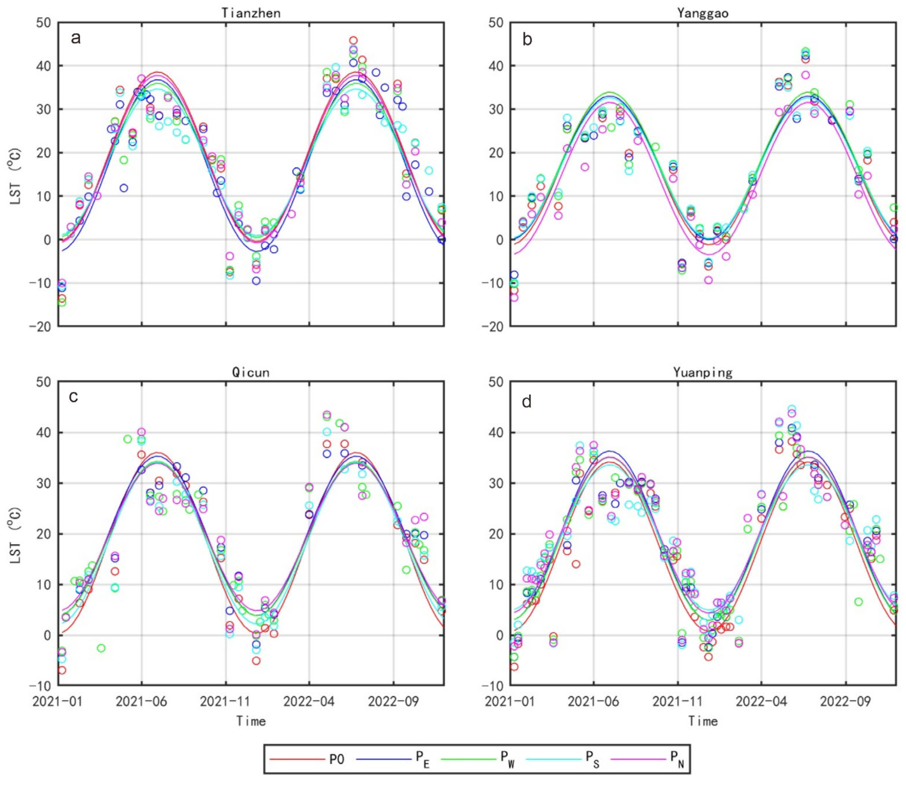
- Geothermal Detection Performance: Known high-temperature geothermal fields (Tianzhen and Yanggao, >100 °C at 100 m depth) exhibit clear thermal anomalies: elevated T0 (+1–2 °C, 3–5% relative) and reduced amplitude (−2 K, 5–10% relative) compared to surrounding areas. These signatures are consistent with theoretical expectations for shallow geothermal systems. However, deeper low-temperature systems (Yuanping and Qicun, 45–50 °C at 300–500 m depth) show weak or ambiguous signals, indicating fundamental detection limitations for deeply buried resources where surface temperature anomalies fall below uncertainty thresholds (~1.5 K).
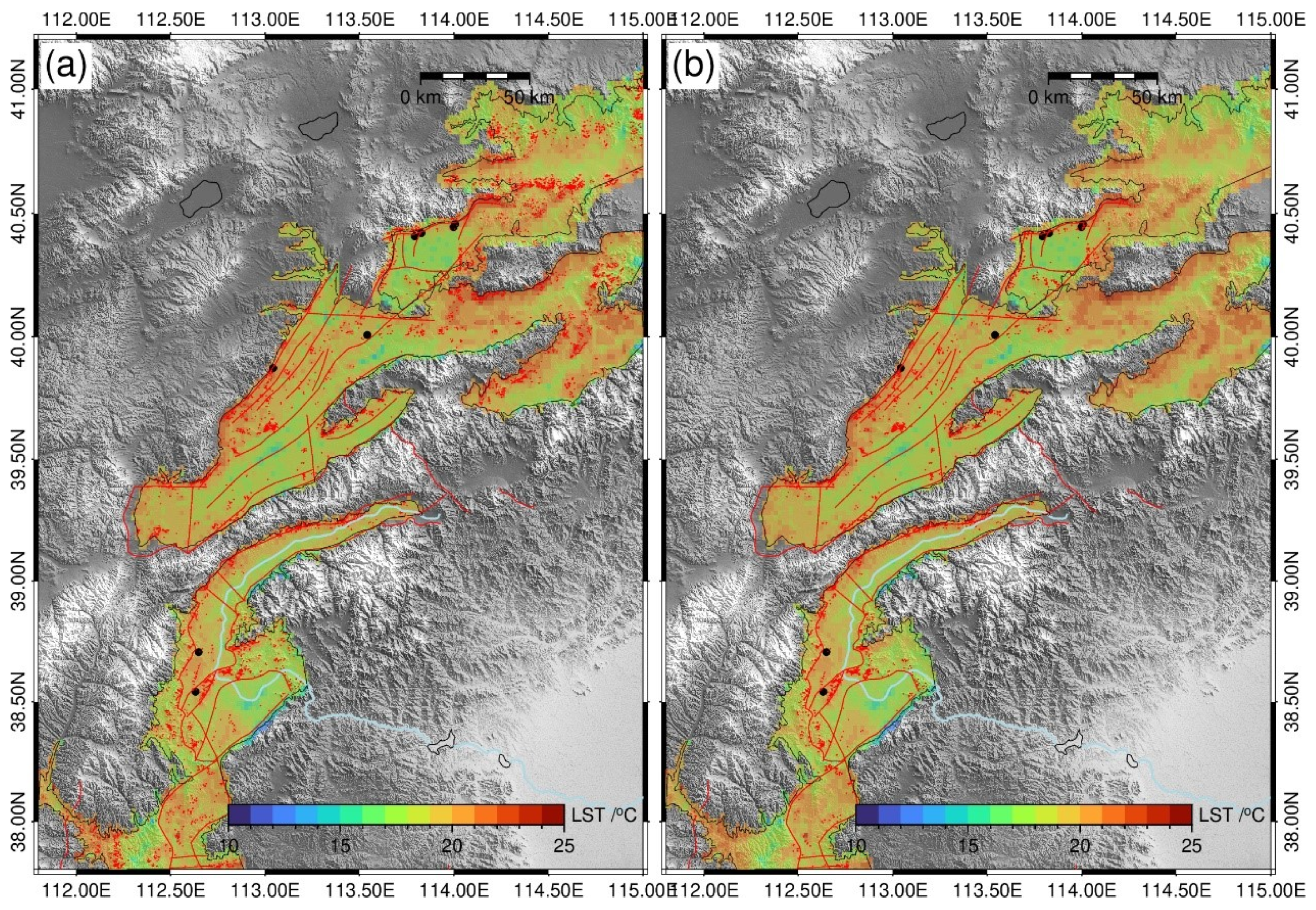
- Extraction Strategy: Sub-regional thermal anomaly extraction (elevation and aspect subdivisions) combined with 5 km fault-proximity buffers successfully identifies thermal anomalies spatially correlated with known geothermal sites. This multi-stage filtering approach reduces false positives from topographic effects and urban heat islands, while leveraging the established structural control of geothermal systems.
- Advantages over Conventional Approaches: Compared to simple temporal averaging, the annual variation model (a) better represents background conditions through temporal integration, (b) naturally accounts for irregular sampling by fitting continuous functions, (c) provides amplitude information reflecting seasonal thermal behavior, and (d) enables the separation of geothermal signals from meteorological variations.
Author Contributions
Funding
Data Availability Statement
Acknowledgments
Conflicts of Interest
References
- Muffler, L.J.P. Assessment of Geothermal Resources of the United States—1978; Geological Survey; US Department of the Interior: Washington, DC, USA, 1979; Volume 790. [Google Scholar]
- Okoroafor, E.R.; Smith, C.M.; Ochie, K.I.; Nwosu, C.J.; Gudmundsdottir, H.; Aljubran, J.M. Machine Learning in Subsurface Geothermal Energy: Two Decades in Review. Geothermics 2022, 102, 102401. [Google Scholar] [CrossRef] [Scilit]
- Gutiérrez-Negrín, L.C.A. Evolution of Worldwide Geothermal Power 2020–2023. Geotherm. Energy 2024, 12, 14. [Google Scholar] [CrossRef] [Scilit]
- Simiyu, S.M. Application of Micro-Seismic Methods to Geothermal Exploration: Examples from the Kenya Rift. In Proceedings of the Short Course VIII on Exploration for Geothermal Resources, Lake Naivasha, Kenya, 31 October–23 November 2009; UNU-GTP: Reykjavik, Iceland, 2009; p. 31. [Google Scholar]
- Yalcin, M.; Kilic Gul, F.; Yildiz, A.; Polat, N.; Basaran, C. The Mapping of Hydrothermal Alteration Related to the Geothermal Activities with Remote Sensing at Akarcay Basin (Afyonkarahisar), Using Aster Data. Arab. J. Geosci. 2020, 13, 1166. [Google Scholar] [CrossRef] [Scilit]
- Silvestri, M.; Marotta, E.; Buongiorno, M.F.; Avvisati, G.; Belviso, P.; Bellucci Sessa, E.; Caputo, T.; Longo, V.; De Leo, V.; Teggi, S. Monitoring of Surface Temperature on Parco Delle Biancane (Italian Geothermal Area) Using Optical Satellite Data, UAV and Field Campaigns. Remote Sens. 2020, 12, 2018. [Google Scholar] [CrossRef] [Scilit]
- Gemitzi, A.; Dalampakis, P.; Falalakis, G. Detecting Geothermal Anomalies Using Landsat 8 Thermal Infrared Remotely Sensed Data. Int. J. Appl. Earth Obs. Geoinf. 2021, 96, 102283. [Google Scholar] [CrossRef] [Scilit]
- Sun, J.; Liu, K.; He, Q.; Yu, T.; Deng, Y. Thermal Infrared Remote Sensing and Soil Gas Radon for Detecting Blind Geothermal Area. Geothermics 2022, 105, 102534. [Google Scholar] [CrossRef] [Scilit]
- Weldeyohannes, T.T.; Hailu, B.T.; Muluneh, A.A.; Kidane, T. Detection of Geothermal Anomalies in the Northern Lake Abaya Geothermal Field, Main Ethiopian Rift. J. Volcanol. Geotherm. Res. 2022, 430, 107638. [Google Scholar] [CrossRef] [Scilit]
- Idi, B.Y.; Maiha, A.I.; Abdullahi, M. Spatial Mapping and Monitoring Thermal Anomaly and Radiative Heat Flux Using Landsat-8 Thermal Infrared Data -A Case Study of Lamurde Hot Spring, Upper Part of Benue Trough, Nigeria. J. Appl. Geophys. 2022, 203, 104654. [Google Scholar] [CrossRef] [Scilit]
- Li, X.; Jiang, G.; Tang, X.; Zuo, Y.; Hu, S.; Zhang, C.; Wang, Y.; Wang, Y.; Zheng, L. Detecting Geothermal Anomalies Using Multi-Temporal Thermal Infrared Remote Sensing Data in the Damxung–Yangbajain Basin, Qinghai–Tibet Plateau. Remote Sens. 2023, 15, 4473. [Google Scholar] [CrossRef] [Scilit]
- Chen, Z.; Grasby, S.E.; Yuan, W.; Liu, X. Ground Surface Temperature Monitoring Data Analysis and Applications to Geothermal Exploration in Volcanic Areas, Mount Meager, Western Canada. Geothermics 2023, 108, 102610. [Google Scholar] [CrossRef] [Scilit]
- Romaguera, M.; Vaughan, R.G.; Ettema, J.; Izquierdo-Verdiguier, E.; Hecker, C.A.; van der Meer, F.D. Detecting Geothermal Anomalies and Evaluating LST Geothermal Component by Combining Thermal Remote Sensing Time Series and Land Surface Model Data. Remote Sens. Environ. 2018, 204, 534–552. [Google Scholar] [CrossRef] [Scilit]
- Chao, J.; Zhao, Z.; Xu, S.; Lai, Z.; Liu, J.; Zhao, F.; Yang, H.; Chen, Q. Geothermal Target Detection Integrating Multi-Source and Multi-Temporal Thermal Infrared Data. Ore Geol. Rev. 2024, 167, 105991. [Google Scholar] [CrossRef] [Scilit]
- Wang, K.; Jiang, Q.; Yu, D.; Yang, Q.; Wang, L.; Han, T.; Xu, X. Detecting Daytime and Nighttime Land Surface Temperature Anomalies Using Thermal Infrared Remote Sensing in Dandong Geothermal Prospect. Int. J. Appl. Earth Obs. Geoinf. 2019, 80, 196–205. [Google Scholar] [CrossRef] [Scilit]
- Peng, X.; Wu, W.; Zheng, Y.; Sun, J.; Hu, T.; Wang, P. Correlation Analysis of Land Surface Temperature and Topographic Elements in Hangzhou, China. Sci. Rep. 2020, 10, 10451. [Google Scholar] [CrossRef] [Scilit] [PubMed]
- Li, Z.-L.; Wu, H.; Duan, S.-B.; Zhao, W.; Ren, H.; Liu, X.; Leng, P.; Tang, R.; Ye, X.; Zhu, J.; et al. Satellite Remote Sensing of Global Land Surface Temperature: Definition, Methods, Products, and Applications. Rev. Geophys. 2023, 61, e2022RG000777. [Google Scholar] [CrossRef] [Scilit]
- Dong, B.; Li, B.; Song, R.; Chen, H.; Wang, Y. Detection and Constraints of Geothermal Latent Heat Zones under the Complex Terrain of the Western Sichuan Plateau: A Fusion of Multi-Source Temporal Remote Sensing Data. Geothermics 2025, 130, 103287. [Google Scholar] [CrossRef] [Scilit]
- Coolbaugh, M.F.; Kratt, C.; Fallacaro, A.; Calvin, W.M.; Taranik, J.V. Detection of Geothermal Anomalies Using Advanced Spaceborne Thermal Emission and Reflection Radiometer (ASTER) Thermal Infrared Images at Bradys Hot Springs, Nevada, USA. Remote Sens. Environ. 2007, 106, 350–359. [Google Scholar] [CrossRef] [Scilit]
- Qin, Z.-H.; Zhang, M.-H.; Karnieli, A.; Berliner, P. Mono-Window Algorithm for Retrieving Land Surface Temperature from Landsat TM6 Data. Dili Xuebao Acta Geogr. Sin. 2001, 56, 456–466. [Google Scholar]
- Qin, Q.; Zhang, N.; Nan, P.; Chai, L. Geothermal Area Detection Using Landsat ETM+ Thermal Infrared Data and Its Mechanistic Analysis—A Case Study in Tengchong, China. Int. J. Appl. Earth Obs. Geoinf. 2011, 13, 552–559. [Google Scholar] [CrossRef] [Scilit]
- Li, Z.-L.; Tang, B.-H.; Wu, H.; Ren, H.; Yan, G.; Wan, Z.; Trigo, I.F.; Sobrino, J.A. Satellite-Derived Land Surface Temperature: Current Status and Perspectives. Remote Sens. Environ. 2013, 131, 14–37. [Google Scholar] [CrossRef] [Scilit]
- Ermida, S.L.; Soares, P.; Mantas, V.; Göttsche, F.-M.; Trigo, I.F. Google Earth Engine Open-Source Code for Land Surface Temperature Estimation from the Landsat Series. Remote Sens. 2020, 12, 1471. [Google Scholar] [CrossRef] [Scilit]
- Carslaw, H.S.; Jaeger, J.C. Conduction of Heat in Solids; Oxford University Press: Oxford, UK, 1980. [Google Scholar]
- Bechtel, B. Robustness of Annual Cycle Parameters to Characterize the Urban Thermal Landscapes. IEEE Geosci. Remote Sens. Lett. 2012, 9, 876–880. [Google Scholar] [CrossRef] [Scilit]
- North, J.S.; Schliep, E.M.; Wikle, C.K. On the Spatial and Temporal Shift in the Archetypal Seasonal Temperature Cycle as Driven by Annual and Semi-Annual Harmonics. Environmetrics 2021, 32, e2665. [Google Scholar] [CrossRef] [Scilit]
- Shen, H.; Huang, L.; Zhang, L.; Wu, P.; Zheng, C. Long-Term and Fine-Scale Satellite Monitoring of the Urban Heat Island Effect by the Fusion of Multi-Temporal and Multi-Sensor Remote Sensed Data: A 26-Year Case Study of the City of Wuhan in China. Remote Sens. Environ. 2016, 172, 109–125. [Google Scholar] [CrossRef] [Scilit]
- Marquardt, D.W. An Algorithm for Least-Squares Estimation of Nonlinear Parameters. J. Soc. Ind. Appl. Math. 1963, 11, 431–441. [Google Scholar] [CrossRef] [Scilit]
- Ma, J.; Shen, H.; Wu, P.; Wu, J.; Gao, M.; Meng, C. Generating Gapless Land Surface Temperature with a High Spatio-Temporal Resolution by Fusing Multi-Source Satellite-Observed and Model-Simulated Data. Remote Sens. Environ. 2022, 278, 113083. [Google Scholar] [CrossRef] [Scilit]
- Barsi, J.A.; Schott, J.R.; Hook, S.J.; Raqueno, N.G.; Markham, B.L.; Radocinski, R.G. Landsat-8 Thermal Infrared Sensor (TIRS) Vicarious Radiometric Calibration. Remote Sens. 2014, 6, 11607–11626. [Google Scholar] [CrossRef] [Scilit]
- Sobrino, J.A.; Jiménez-Muñoz, J.C.; Paolini, L. Land Surface Temperature Retrieval from LANDSAT TM 5. Remote Sens. Environ. 2004, 90, 434–440. [Google Scholar] [CrossRef] [Scilit]
- Dash, P.; Göttsche, F.; Olesen, F.; Fischer, H. Land Surface Temperature and Emissivity Estimation from Passive Sensor Data: Theory and Practice-Current Trends. Int. J. Remote Sens. 2002, 23, 2563–2594. [Google Scholar] [CrossRef] [Scilit]
- Weng, Q. Thermal Infrared Remote Sensing for Urban Climate and Environmental Studies: Methods, Applications, and Trends. ISPRS J. Photogramm. Remote Sens. 2009, 64, 335–344. [Google Scholar] [CrossRef] [Scilit]
- Brown, S.; Rodi, W.L.; Seracini, M.; Gu, C.; Fehler, M.; Faulds, J.; Smith, C.M.; Treitel, S. Bayesian Neural Networks for Geothermal Resource Assessment: Prediction with Uncertainty. arXiv 2022, arXiv:2209.15543. [Google Scholar]
- Han, D.; Liang, X.; Currell, M.; Song, X.; Chen, Z.; Jin, M.; Liu, C.; Han, Y. Environmental Isotopic and Hydrochemical Characteristics of Groundwater Systems in Daying and Qicun Geothermal Fields, Xinzhou Basin, Shanxi, China. Hydrol. Process. 2010, 24, 3157–3176. [Google Scholar] [CrossRef] [Scilit]
- Lu, Z.; Yang, Y.; Mo, Y.; Liao, H.; Cai, Y. Investigation and Evaluation of Geothermal Resources in Northern Shanxi Province, China. Energies 2025, 18, 1494. [Google Scholar] [CrossRef] [Scilit]
- Yan, X.; Wei, S.; Zhang, W.; Liu, F.; Liao, Y. Reservoirs and Hydrogeochemical Characterizations of the Yanggao Geothermal Field in Shanxi Province, China. Water 2024, 16, 669. [Google Scholar] [CrossRef] [Scilit]
- Khutorskoy, M.D.; Teveleva, E.A. Heat Flow in Continental Rift Zones: A New Approach to Data Interpretation. Volcanol. Seismol. 2024, 18, 236–250. [Google Scholar] [CrossRef] [Scilit]
- Noorollahi, Y.; Itoi, R.; Fujii, H.; Tanaka, T. GIS Integration Model for Geothermal Exploration and Well Siting. Geothermics 2008, 37, 107–131. [Google Scholar] [CrossRef] [Scilit]
- Mudunuru, M.K.; Ahmmed, B.; Rau, E.; Vesselinov, V.V.; Karra, S. Machine Learning for Geothermal Resource Exploration in the Tularosa Basin, New Mexico. Energies 2023, 16, 3098. [Google Scholar] [CrossRef] [Scilit]
- Mia, M.d.B.; Nishijima, J.; Fujimitsu, Y. Exploration and Monitoring Geothermal Activity Using Landsat ETM+images: A Case Study at Aso Volcanic Area in Japan. J. Volcanol. Geotherm. Res. 2014, 275, 14–21. [Google Scholar] [CrossRef] [Scilit]




| Feature Points | LST | |||
|---|---|---|---|---|
| Annual Average | T0 | A | Elevation | |
| Tianzhen | 17.32 | 19.06 | 19.52 | 1043 |
| Yanggao | 14.17 | 16.36 | 17.58 | 1043 |
| Qicun | 16.00 | 18.20 | 17.85 | 833 |
| Yuanping | 15.41 | 17.45 | 16.70 | 894 |
| Site | Water Temperature | Feature Points | LST | |||
|---|---|---|---|---|---|---|
| Annual Average | T0 | A | Elevation | |||
| Tianzhen | 100 m 104 °C | P0 | 17.32 | 19.06 | 19.52 | 1043 |
| PE | 18.04 | 17.02 | 19.77 | 1043 | ||
| PW | 17.38 | 18.21 | 17.75 | 1043 | ||
| PS | 17.20 | 17.76 | 16.88 | 1043 | ||
| PN | 16.63 | 18.51 | 19.30 | 1043 | ||
| Yanggao | 100 m 104 °C | P0 | 14.82 | 16.84 | 16.71 | 1043 |
| PE | 15.27 | 16.19 | 15.79 | 1043 | ||
| PW | 14.59 | 16.20 | 17.25 | 1043 | ||
| PS | 15.35 | 16.31 | 16.13 | 1043 | ||
| PN | 15.06 | 16.16 | 18.23 | 1226 | ||
| Qicun | 500 m 50 °C | P0 | 16.00 | 18.20 | 17.85 | 833 |
| PE | 17.40 | 19.57 | 15.72 | 833 | ||
| PW | 16.42 | 19.05 | 15.23 | 833 | ||
| PS | 16.10 | 18.12 | 15.94 | 833 | ||
| PN | 17.48 | 19.34 | 14.57 | 833 | ||
| Yuanping | 300 m 45 °C | P0 | 15.41 | 17.45 | 16.70 | 894 |
| PE | 18.02 | 19.62 | 16.70 | 894 | ||
| PW | 16.45 | 18.98 | 16.08 | 894 | ||
| PS | 16.43 | 19.25 | 14.33 | 894 | ||
| PN | 17.52 | 19.73 | 15.41 | 894 | ||
Disclaimer/Publisher’s Note: The statements, opinions and data contained in all publications are solely those of the individual author(s) and contributor(s) and not of MDPI and/or the editor(s). MDPI and/or the editor(s) disclaim responsibility for any injury to people or property resulting from any ideas, methods, instructions or products referred to in the content. |
© 2026 by the authors. Licensee MDPI, Basel, Switzerland. This article is an open access article distributed under the terms and conditions of the Creative Commons Attribution (CC BY) license.
Share and Cite
Wei, M.; Jiang, G.; Zou, L.; Wen, X.; Li, Z. Geothermal Resource Exploration Using Multi-Temporal Infrared Remote Sensing Data Based on Annual Temperature Variation Model. Remote Sens. 2026, 18, 1362. https://doi.org/10.3390/rs18091362
Wei M, Jiang G, Zou L, Wen X, Li Z. Geothermal Resource Exploration Using Multi-Temporal Infrared Remote Sensing Data Based on Annual Temperature Variation Model. Remote Sensing. 2026; 18(9):1362. https://doi.org/10.3390/rs18091362
Chicago/Turabian StyleWei, Meihua, Guangzheng Jiang, Luyu Zou, Xiaoyi Wen, and Zhenyu Li. 2026. "Geothermal Resource Exploration Using Multi-Temporal Infrared Remote Sensing Data Based on Annual Temperature Variation Model" Remote Sensing 18, no. 9: 1362. https://doi.org/10.3390/rs18091362
APA StyleWei, M., Jiang, G., Zou, L., Wen, X., & Li, Z. (2026). Geothermal Resource Exploration Using Multi-Temporal Infrared Remote Sensing Data Based on Annual Temperature Variation Model. Remote Sensing, 18(9), 1362. https://doi.org/10.3390/rs18091362