Spatial Heterogeneity and Drivers of Vertical Error in Global DEMs: An Explainable Machine Learning Approach in Complex Subtropical Coastal Zones


Highlights
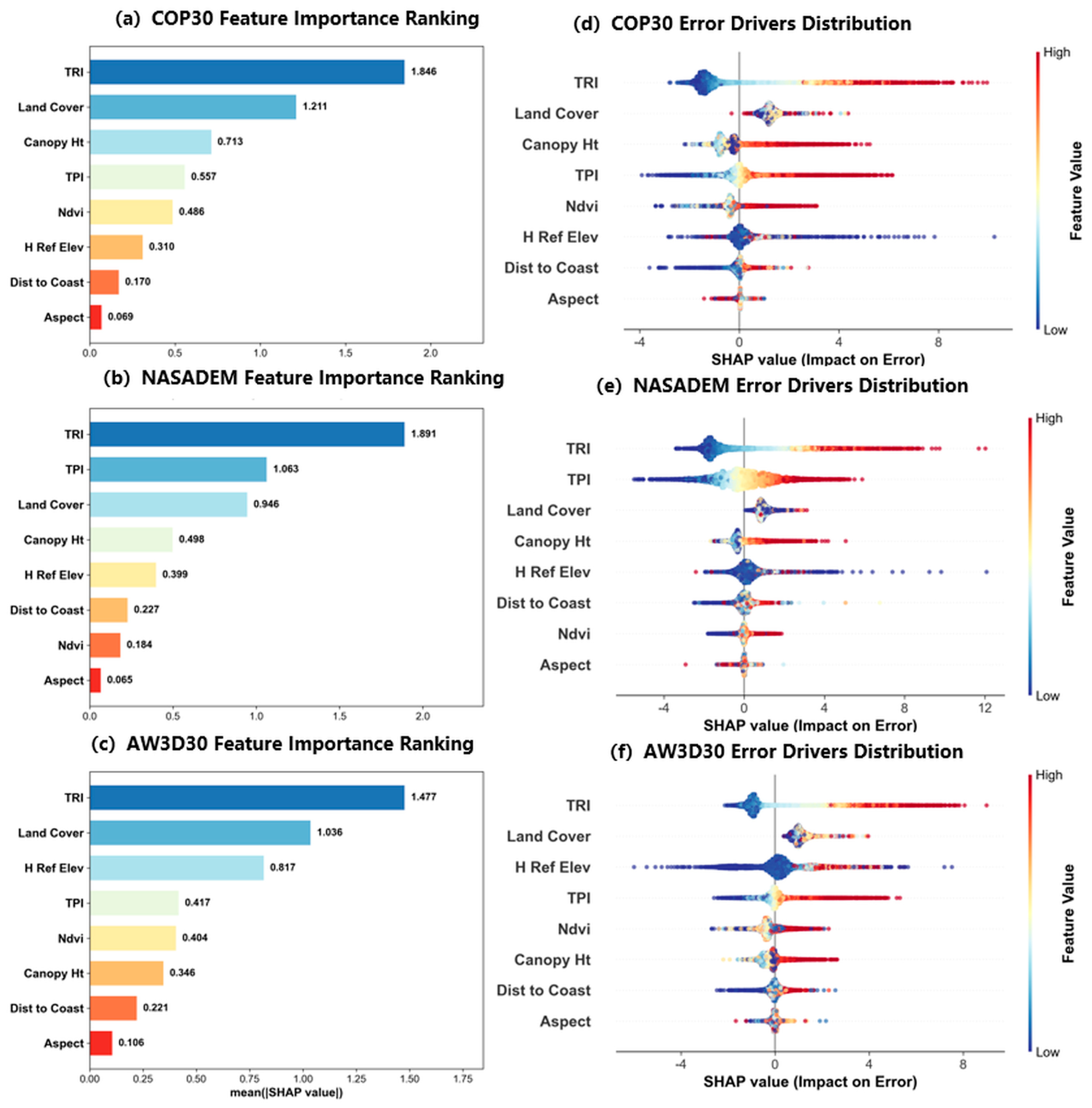
- Terrain Ruggedness (TRI) and categorically encoded Land Cover act as the universally dominant error drivers across all global DEMs, with complex surface types systematically introducing positive elevation biases.
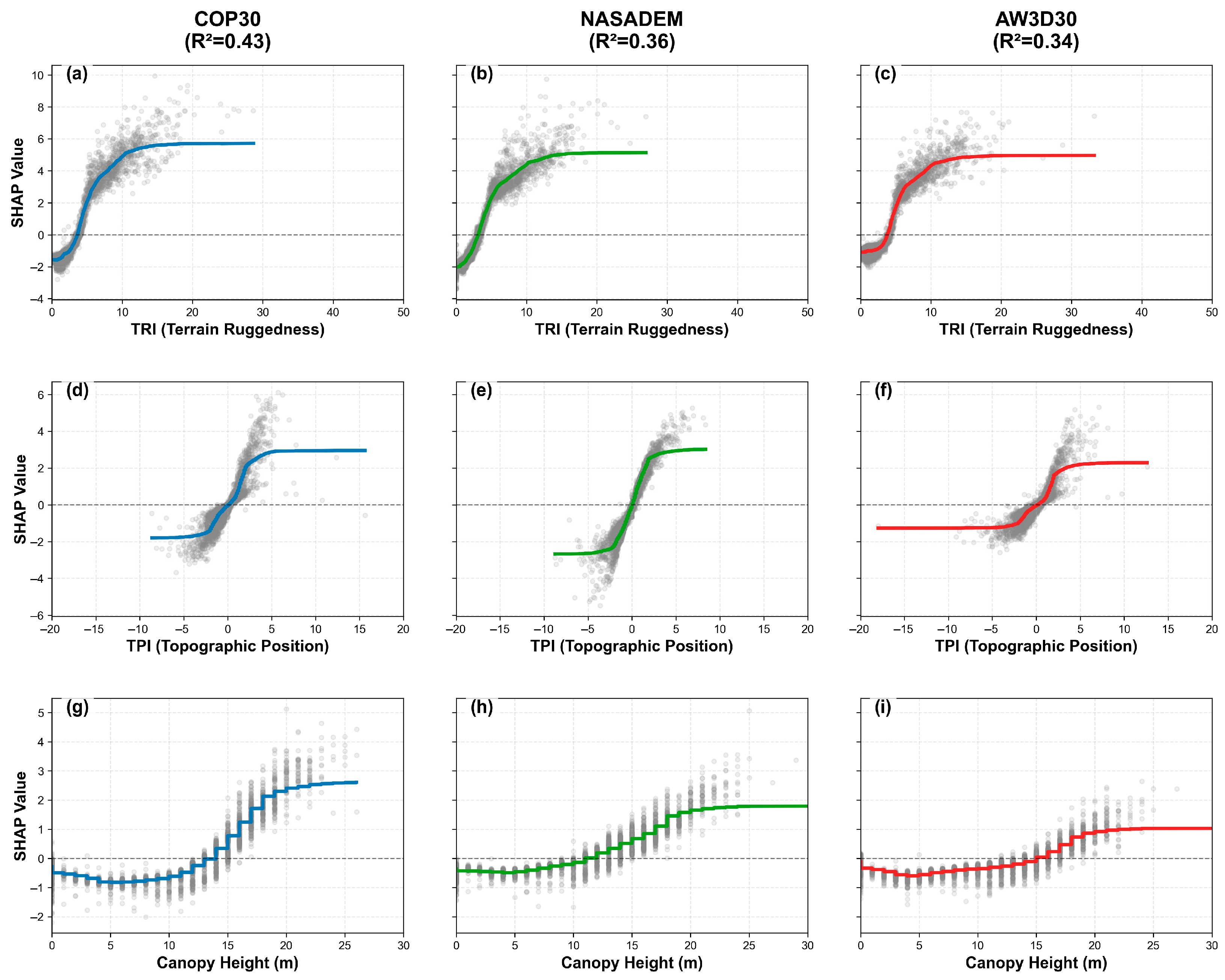
- Secondary to these shared factors, distinct sensor-specific mechanisms govern the remaining errors: Canopy Height for the X-band COP30, Topographic Position (TPI) for the C-band NASADEM, and absolute Elevation for the optical AW3D30.
- The results indicate that, in reprocessed datasets like NASADEM, radiometric factors (e.g., dense vegetation on ridges) and algorithmic processing (e.g., hydro-flattening in valleys) can overpower pure geometric smoothing effects.
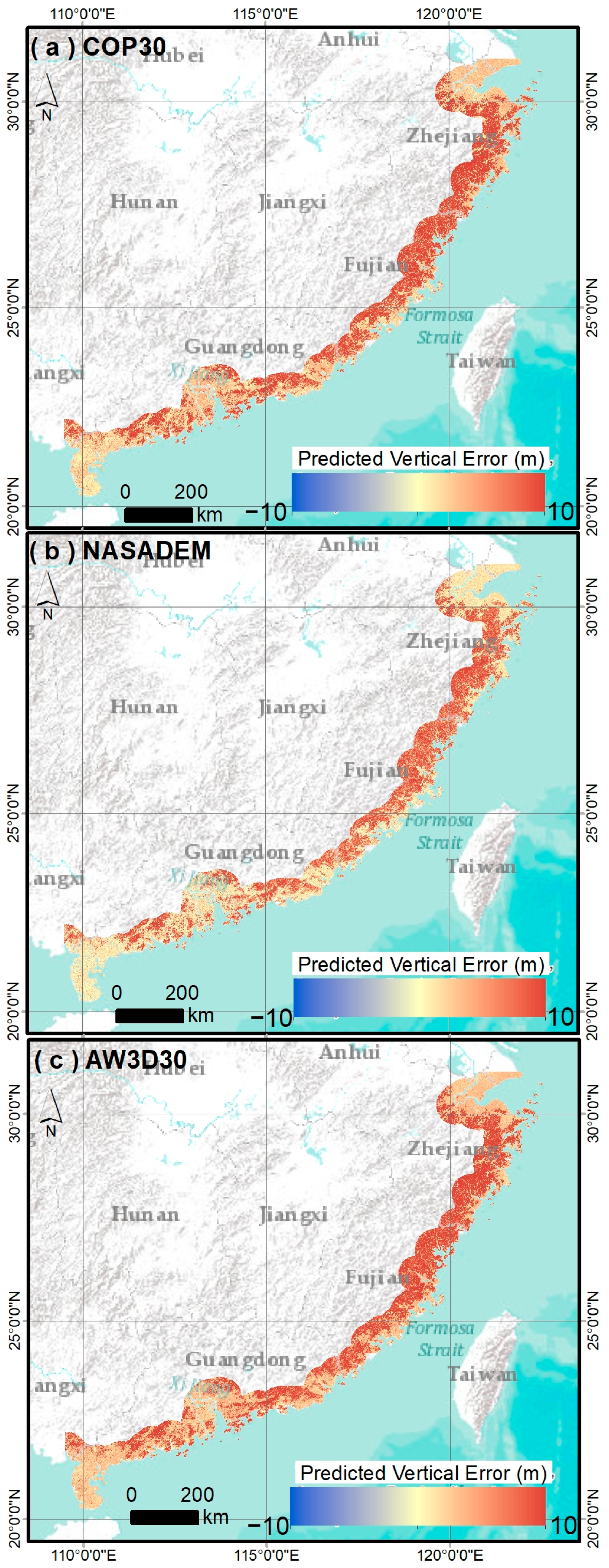
- By successfully decomposing deterministic terrain biases from sensor-specific random noise (explaining ~40% of the total error variance), this study provides a physics-informed framework for developing more targeted elevation correction algorithms and improved regional DEM accuracy.
Abstract
1. Introduction
2. Study Area and Datasets
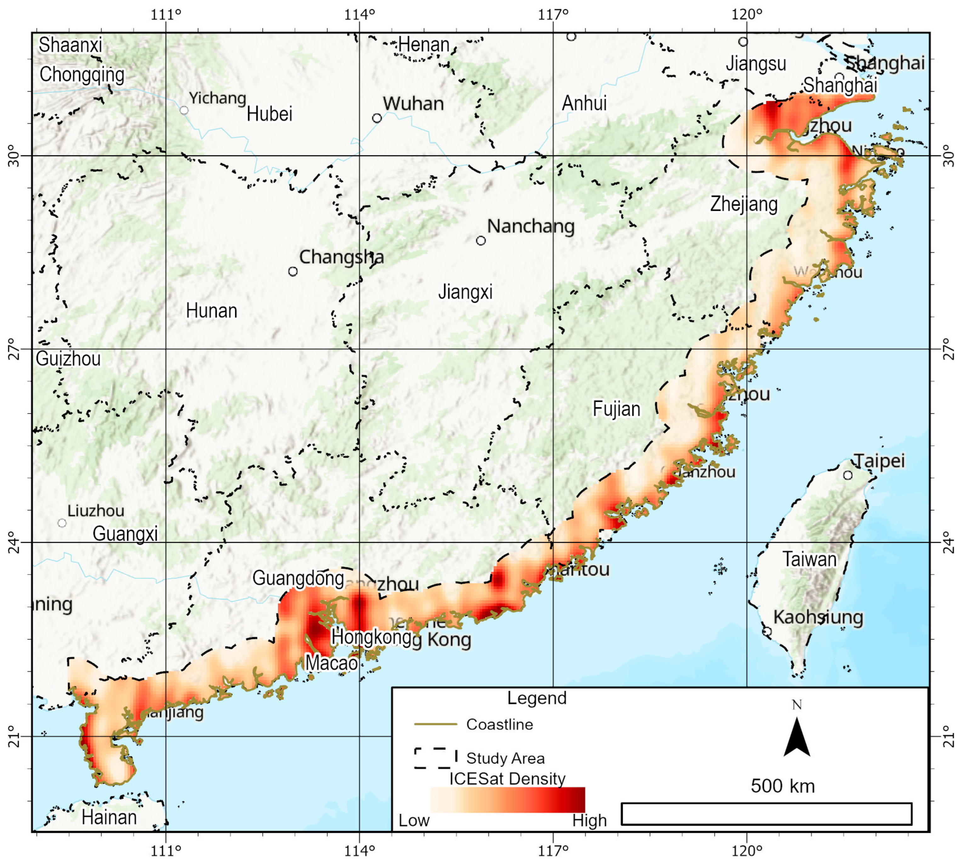
2.1. Study Area
2.2. DEMs
2.3. ICESat-2 ATL08
2.4. Covariates for Error Modeling
3. Methods
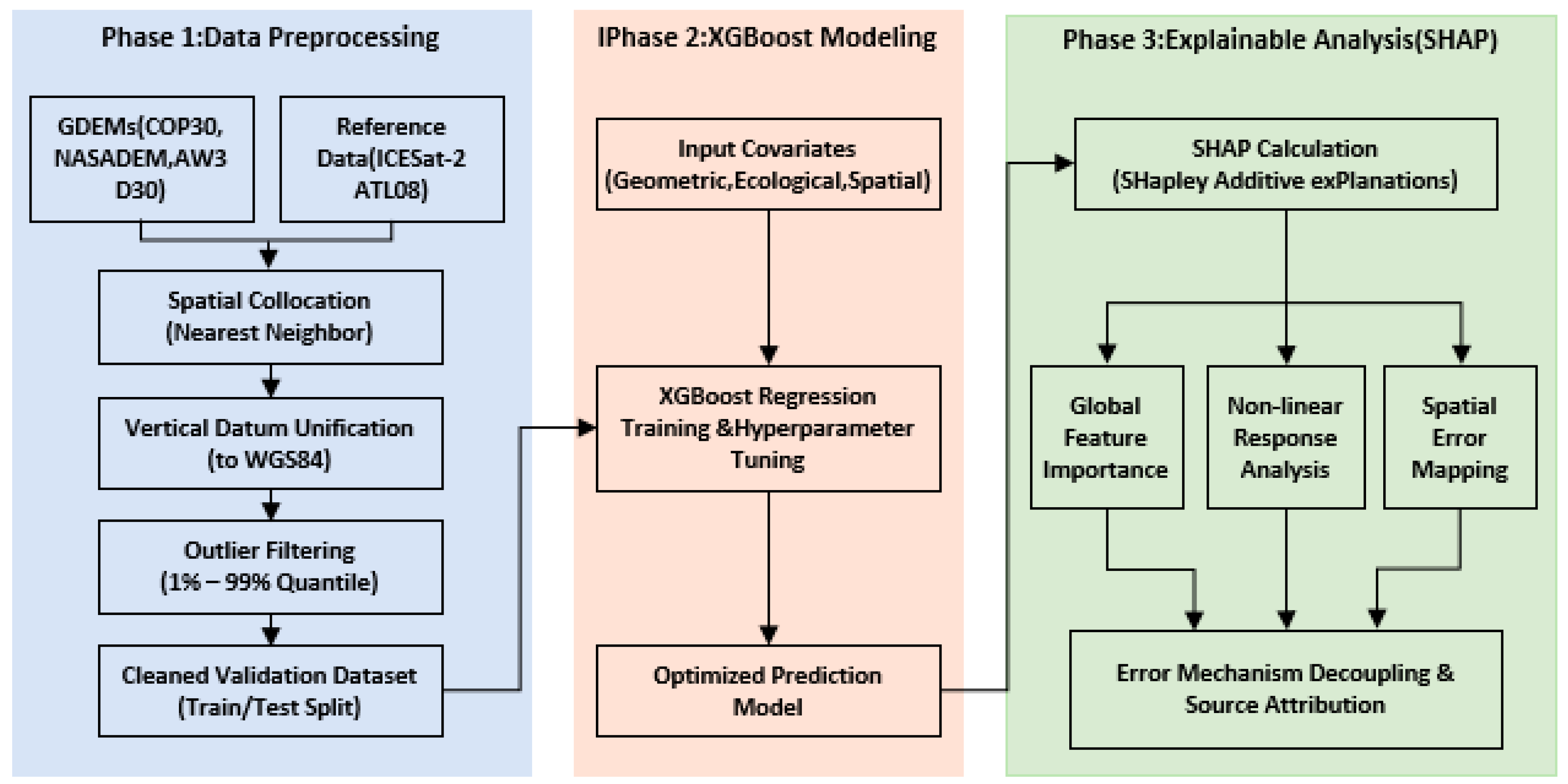
3.1. Data Preprocessing
3.2. XGBoost Modeling
3.3. Statistical Metrics
3.4. SHAP Interpretation
4. Results
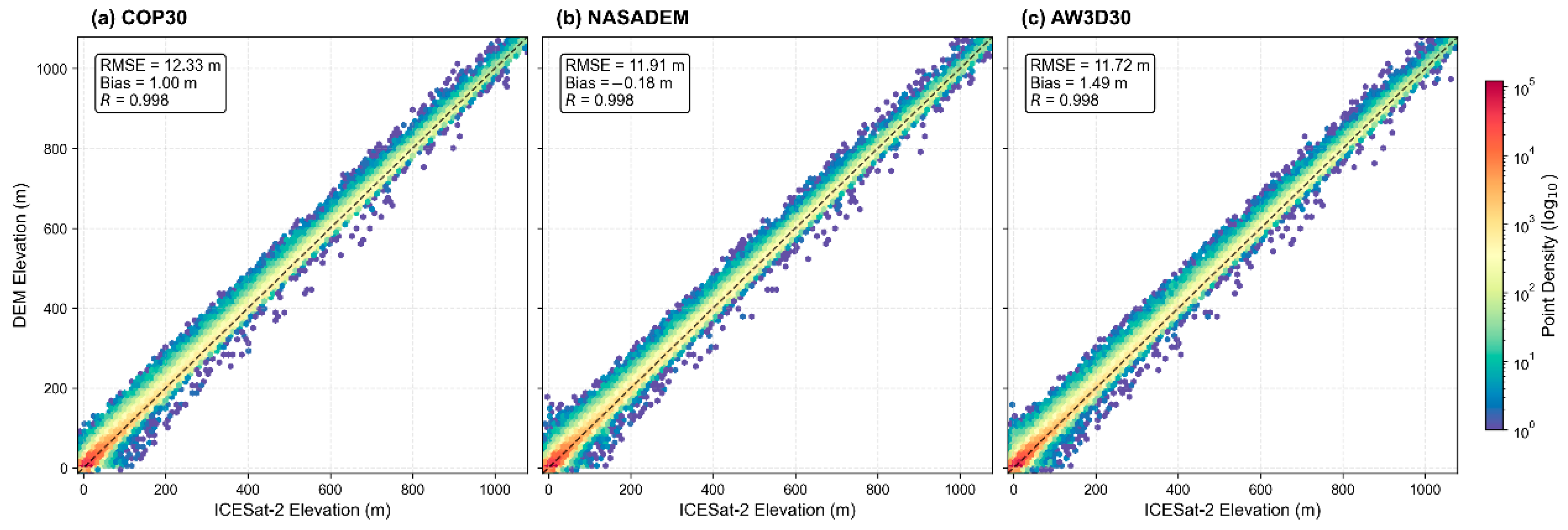
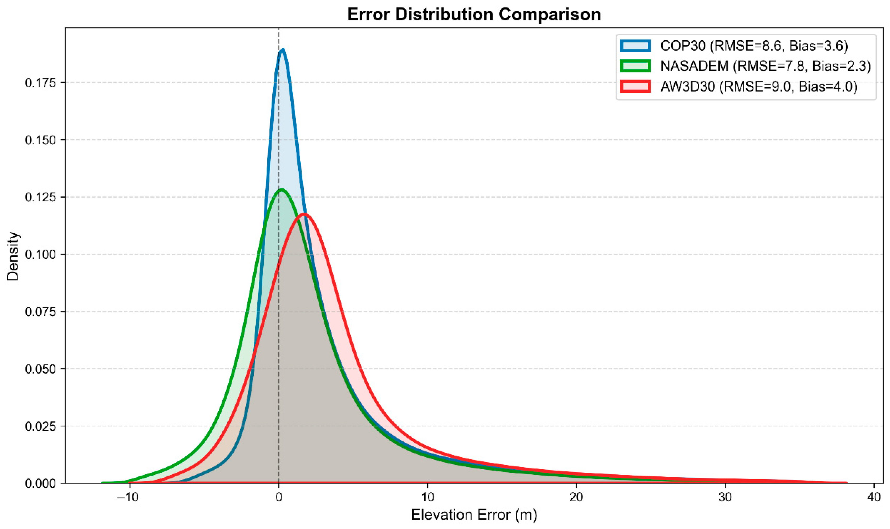
4.1. Overall Vertical Accuracy Assessment
4.2. Global Feature Importance and Error Drivers
4.3. Non-Linear Error Response to Topography and Vegetation
4.4. Spatial Distribution of Predicted Errors
4.5. Practical Application: DEM Error Correction
5. Discussion
5.1. Decomposition of Systematic and Random Errors
5.2. Comparison with Previous Studies and Limitations
6. Conclusions
Supplementary Materials
Author Contributions
Funding
Data Availability Statement
Acknowledgments
Conflicts of Interest
Abbreviations
| DEM | Digital elevation model |
| ALOS | Advanced Land Observing Satellite |
| AW3D30 | ALOS World 3D-30 m |
| COP30 | Copernicus DEM |
| NASA | National Aeronautics and Space Administration |
| ATLAS | The advanced topographic laser altimeter system |
| NDVI | Normalized difference vegetation index |
| SAR | Synthetic aperture radar |
| SHAP | SHapley Additive exPlanations |
| XGBoost | eXtreme Gradient Boosting |
| RMSE | Root mean square error |
| TPI | Topographic position index |
| TRI | Terrain ruggedness index |
References
- Moore, I.D.; Grayson, R.B.; Ladson, A.R. Digital Terrain Modelling: A Review of Hydrological, Geomorphological, and Biological Applications. Hydrol. Process. 1991, 5, 3–30. [Google Scholar] [CrossRef] [Scilit]
- Coveney, S.; Roberts, K. Lightweight UAV Digital Elevation Models and Orthoimagery for Environmental Applications: Data Accuracy Evaluation and Potential for River Flood Risk Modelling. Int. J. Remote Sens. 2017, 38, 3159–3180. [Google Scholar] [CrossRef] [Scilit]
- Fattahi, H.; Amelung, F. DEM Error Correction in InSAR Time Series. IEEE Trans. Geosci. Remote Sens. 2013, 51, 4249–4259. [Google Scholar] [CrossRef] [Scilit]
- Hawker, L.; Neal, J.; Bates, P. Accuracy Assessment of the TanDEM-X 90 Digital Elevation Model for Selected Floodplain Sites. Remote Sens. Environ. 2019, 232, 111319. [Google Scholar] [CrossRef] [Scilit]
- Uuemaa, E.; Ahi, S.; Montibeller, B.; Muru, M.; Kmoch, A. Vertical Accuracy of Freely Available Global Digital Elevation Models (Aster, Aw3d30, Merit, Tandem-x, Srtm, and Nasadem). Remote Sens. 2020, 12, 3482. [Google Scholar] [CrossRef] [Scilit]
- Meadows, M.; Jones, S.; Reinke, K. Vertical Accuracy Assessment of Freely Available Global DEMs (FABDEM, Copernicus DEM, NASADEM, AW3D30 and SRTM) in Flood-Prone Environments. Int. J. Digit. Earth 2024, 17, 2308734. [Google Scholar] [CrossRef] [Scilit]
- Horritt, M.S.; Bates, P.D. Evaluation of 1D and 2D Numerical Models for Predicting River Flood Inundation. J. Hydrol. 2002, 268, 87–99. [Google Scholar] [CrossRef] [Scilit]
- Marsh, C.B.; Harder, P.; Pomeroy, J.W. Validation of FABDEM, a Global Bare-Earth Elevation Model, against UAV-Lidar Derived Elevation in a Complex Forested Mountain Catchment. Environ. Res. Commun. 2023, 5, 031009. [Google Scholar] [CrossRef] [Scilit]
- Li, H.; Zhao, J.; Yan, B.; Yue, L.; Wang, L. Global DEMs Vary from One to Another: An Evaluation of Newly Released Copernicus, NASA and AW3D30 DEM on Selected Terrains of China Using ICESat-2 Altimetry Data. Int. J. Digit. Earth 2022, 15, 1149–1168. [Google Scholar] [CrossRef] [Scilit]
- Carrera-Hernández, J.J. Not All DEMs Are Equal: An Evaluation of Six Globally Available 30 m Resolution DEMs with Geodetic Benchmarks and LiDAR in Mexico. Remote Sens. Environ. 2021, 261, 112474. [Google Scholar] [CrossRef] [Scilit]
- Saksena, S.; Merwade, V. Incorporating the Effect of DEM Resolution and Accuracy for Improved Flood Inundation Mapping. J. Hydrol. 2015, 530, 180–194. [Google Scholar] [CrossRef] [Scilit]
- Simard, M.; Denbina, M.; Marshak, C.; Neumann, M. A Global Evaluation of Radar-Derived Digital Elevation Models: SRTM, NASADEM, and GLO-30. J. Geophys. Res. Biogeosci. 2024, 129, e2023JG007672. [Google Scholar] [CrossRef] [Scilit]
- Li, M.; Yin, X.; Tang, B.H.; Yang, M. Accuracy Assessment of High-Resolution Globally Available Open-Source DEMs Using ICESat/GLAS over Mountainous Areas, A Case Study in Yunnan Province, China. Remote Sens. 2023, 15, 1952. [Google Scholar] [CrossRef] [Scilit]
- Lundberg, S.M.; Lee, S.I. A Unified Approach to Interpreting Model Predictions. In Proceedings of the Advances in Neural Information Processing Systems, Long Beach, CA, USA, 4–9 December 2017. [Google Scholar]
- Shi, N.; Li, Y.; Wen, L.; Zhang, Y. Rapid Prediction of Landslide Dam Stability Considering the Missing Data Using XGBoost Algorithm. Landslides 2022, 19, 2951–2963. [Google Scholar] [CrossRef] [Scilit]
- Wang, H.; Liu, L.; Yin, L.; Shen, J.; Li, S. Exploring the Complex Relationships and Drivers of Ecosystem Services across Different Geomorphological Types in the Beijing-Tianjin-Hebei Region, China (2000–2018). Ecol. Indic. 2021, 121, 107116. [Google Scholar] [CrossRef] [Scilit]
- Wang, M.; Li, Y.; Yuan, H.; Zhou, S.; Wang, Y.; Adnan Ikram, R.M.; Li, J. An XGBoost-SHAP Approach to Quantifying Morphological Impact on Urban Flooding Susceptibility. Ecol. Indic. 2023, 156, 111137. [Google Scholar] [CrossRef] [Scilit]
- You, J.; Yin, F.; Zhang, B.; Zhou, M.; Qing, Y.; Chen, Y.; Gao, L. A Novel Environmental Nndicator: Compound Wind Droughts and Heat Waves for Assessing Climate-Driven Ecological and Energy Sustainability. Ecol. Indic. 2025, 178, 114114. [Google Scholar] [CrossRef] [Scilit]
- Cheshmehzangi, A.; Tang, T. Guangdong-Fujian-Zhejiang Coastal Region: A Network Corridor Between Three Coastal Provinces. In China’s City Cluster Development in the Race to Carbon Neutrality; Springer Nature: Singapore, 2022. [Google Scholar]
- Guth, P.L.; Van Niekerk, A.; Grohmann, C.H.; Muller, J.P.; Hawker, L.; Florinsky, I.V.; Gesch, D.; Reuter, H.I.; Herrera-Cruz, V.; Riazanoff, S.; et al. Digital Elevation Models: Terminology and Definitions. Remote Sens. 2021, 13, 3581. [Google Scholar] [CrossRef] [Scilit]
- Tadono, T.; Takaku, J.; Tsutsui, K.; Oda, F.; Nagai, H. Status of “ALOS World 3D (AW3D)” Global DSM Generation. In Proceedings of the International Geoscience and Remote Sensing Symposium (IGARSS), Milan, Italy, 26–31 July 2015. [Google Scholar]
- Crippen, R.; Buckley, S.; Agram, P.; Belz, E.; Gurrola, E.; Hensley, S.; Kobrick, M.; Lavalle, M.; Martin, J.; Neumann, M.; et al. Nasadem Global Elevation Model: Methods and Progress. Int. Arch. Photogramm. Remote Sens. Spat. Inf. Sci. 2016, XLI-B4, 125–128. [Google Scholar] [CrossRef] [Scilit]
- Neumann, T.A.; Martino, A.J.; Markus, T.; Bae, S.; Bock, M.R.; Brenner, A.C.; Brunt, K.M.; Cavanaugh, J.; Fernandes, S.T.; Hancock, D.W.; et al. The Ice, Cloud, and Land Elevation Satellite—2 Mission: A Global Geolocated Photon Product Derived from the Aadvanced Ttopographic Llaser Aaltimeter Ssystem. Remote Sens. Environ. 2019, 233, 111325. [Google Scholar] [CrossRef] [Scilit]
- Xiang, J.; Li, H.; Zhao, J.; Cai, X.; Li, P. Inland Water Level Measurement from Spaceborne Laser Altimetry: Validation and Comparison of Three Missions over the Great Lakes and Lower Mississippi River. J. Hydrol. 2021, 597, 126312. [Google Scholar] [CrossRef] [Scilit]
- Malashin, R.; Mikhalkova, M. Method for Sharpening Combined Stereo Images in the Presence of Optical Distortions. J. Opt. Technol. 2023, 90, 444–450. [Google Scholar] [CrossRef] [Scilit]
- Wang, Z.; Ma, X.; Peng, J.; Shi, M.; Peng, Y.; Su, Y.; Guo, Z.; Wang, W. Quantitative Analysis of SAR Image Geometric Distortion and Its Application in Deformation Rate Fusion Mapping. IEEE J. Sel. Top. Appl. Earth Obs. Remote Sens. 2024, 17, 3780–3790. [Google Scholar] [CrossRef] [Scilit]
- Shawn, R.; Degloria, S.D.; Elliot, R. A Terrain Ruggedness Index That Quantifies Topographic Heterogeneity. Intermt. J. Sci. 1999, 5, 23–27. [Google Scholar]
- Weiss, A.D. Topographic Position and Landforms Analysis, The Nature Conservancy. In Proceedings of the Poster Presentation, ESRI User Conference, San Diego, CA, USA, 9–13 July 2001; Volume 64. [Google Scholar]
- Hancock, G.R.; Martinez, C.; Evans, K.G.; Moliere, D.R. A Comparison of SRTM and High-Resolution Digital Elevation Models and Their Use in Catchment Geomorphology and Hydrology: Australian Examples. Earth Surf. Process. Landf. 2006, 31, 1394–1412. [Google Scholar] [CrossRef] [Scilit]
- Bekaert, D.P.S.; Walters, R.J.; Wright, T.J.; Hooper, A.J.; Parker, D.J. Statistical Comparison of InSAR Tropospheric Correction Techniques. Remote Sens. Environ. 2015, 170, 40–47. [Google Scholar] [CrossRef] [Scilit]
- Lang, N.; Jetz, W.; Schindler, K.; Wegner, J.D. A High-Resolution Canopy Height Model of the Earth. Nat. Ecol. Evol. 2023, 7, 1778–1789. [Google Scholar] [CrossRef] [Scilit] [PubMed]
- Chaaban, F.; El Khattabi, J.; Darwishe, H. Accuracy Assessment of ESA WorldCover 2020 and ESRI 2020 Land Cover Maps for a Region in Syria. J. Geovisualization Spat. Anal. 2022, 6, 31. [Google Scholar] [CrossRef] [Scilit]
- Ogino, S.Y.; Yamanaka, M.D.; Mori, S.; Matsumoto, J. Tropical Coastal Dehydrator in Global Atmospheric Water Circulation. Geophys. Res. Lett. 2017, 44, 11–636. [Google Scholar] [CrossRef] [Scilit]
- Zou, G.X.; Tong, C.; Sun, H.L.; Peng, P. Research on Electromagnetic Scattering Characteristics of Combined Conducting and Dielectric Target above Coastal Environment. IEEE Access 2020, 8, 169286–169303. [Google Scholar] [CrossRef] [Scilit]
- Höhle, J.; Höhle, M. Accuracy Assessment of Digital Elevation Models by Means of Robust Statistical Methods. ISPRS J. Photogramm. Remote Sens. 2009, 64, 398–406. [Google Scholar] [CrossRef] [Scilit]
- Samuele, D.P.; Filippo, S.; Orusa, T.; Enrico, B.M. Mapping SAR Geometric Distortions and Their Stability along Time: A New Tool in Google Earth Engine Based on Sentinel-1 Image Time Series. Int. J. Remote Sens. 2021, 42, 9135–9154. [Google Scholar] [CrossRef] [Scilit]
- Liu, H.H.; Zhao, Y.J.; Wang, L.; Liu, Y.Y. Comparison of DEM Accuracies Generated from Different Stereo Pairs over a Plateau Mountainous Area. J. Mt. Sci. 2021, 18, 1580–1590. [Google Scholar] [CrossRef] [Scilit]
- Xu, K.; Zhao, L.; Chen, E.; Li, K.; Liu, D.; Li, T.; Li, Z.; Fan, Y. Forest Height Estimation Approach Combining P-Band and X-Band Interferometric SAR Data. Remote Sens. 2022, 14, 3070. [Google Scholar] [CrossRef] [Scilit]
- Purinton, B.; Bookhagen, B. Beyond Vertical Point Accuracy: Assessing Inter-Pixel Consistency in 30 m Global DEMs for the Arid Central Andes. Front. Earth Sci. 2021, 9, 758606. [Google Scholar] [CrossRef] [Scilit]
- Li, H.; Zhao, J. Evaluation of the Newly Released Worldwide AW3D30 DEM over Typical Landforms of China Using Two Global DEMs and ICESat/GLAS Data. IEEE J. Sel. Top. Appl. Earth Obs. Remote Sens. 2018, 11, 2874361. [Google Scholar] [CrossRef] [Scilit]
- Rizzoli, P.; Martone, M.; Gonzalez, C.; Wecklich, C.; Borla Tridon, D.; Bräutigam, B.; Bachmann, M.; Schulze, D.; Fritz, T.; Huber, M.; et al. Generation and Performance Assessment of the Global TanDEM-X Digital Elevation Model. ISPRS J. Photogramm. Remote Sens. 2017, 132, 119–139. [Google Scholar] [CrossRef] [Scilit]
- Farr, T.G.; Rosen, P.A.; Caro, E.; Crippen, R.; Duren, R.; Hensley, S.; Kobrick, M.; Paller, M.; Rodriguez, E.; Roth, L.; et al. The Shuttle Radar Topography Mission. Rev. Geophys. 2007, 45, RG2004. [Google Scholar] [CrossRef] [Scilit]
- Zebker, H.A.; Rosen, P.A.; Hensley, S. Atmospheric Effects in Interferometric Synthetic Aperture Radar Surface Deformation and Topographic Maps. J. Geophys. Res. Solid Earth 1997, 102, 7547–7563. [Google Scholar] [CrossRef] [Scilit]
- Simard, M.; Rivera-Monroy, V.H.; Mancera-Pineda, J.E.; Castañeda-Moya, E.; Twilley, R.R. A Systematic Method for 3D Mapping of Mangrove Forests Based on Shuttle Radar Topography Mission Elevation Data, ICEsat/GLAS Waveforms and Field Data: Application to Ciénaga Grande de Santa Marta, Colombia. Remote Sens. Environ. 2008, 112, 2131–2144. [Google Scholar] [CrossRef] [Scilit]
- Hayakawa, Y.S.; Oguchi, T.; Lin, Z. Comparison of New and Existing Global Digital Elevation Models: ASTER G-DEM and SRTM-3. Geophys. Res. Lett. 2008, 35, 17404–17405. [Google Scholar] [CrossRef] [Scilit]
- Jarvis, A.; Rubiano, J.; Nelson, A.; Farrow, A.; Mulligan, M. Practical Use of SRTM Data in the Tropics—Comparisons with Digital Elevation Models Generated from Cartographic Data. Trop. Agric. 2004, 198, 1–32. [Google Scholar]





| Category | Covariate | Source/Derivation |
|---|---|---|
| Geometric | Reference Elevation | ICESat-2 ATL08 |
| Slope | Derived from NASADEM (30 m) | |
| Aspect | Derived from NASADEM (30 m) | |
| TRI | Derived from NASADEM (3 × 3 window) | |
| TPI | Derived from NASADEM (30 m) | |
| Ecological | Canopy Height | Global canopy height map |
| NDVI | Landsat-8 imagery | |
| LULC | ESA WorldCover v200 (10 m) | |
| Spatial | Distance to Coast | Euclidean distance from coastline |
| Metrics | COP30 | NASADEM | AW3D30 |
|---|---|---|---|
| RMSE (m) | 8.559 | 7.775 | 9.001 |
| MAE (m) | 4.307 | 4.256 | 5.142 |
| Bias (m) | 3.567 | 2.311 | 3.979 |
| Std Dev (m) | 7.78 | 7.423 | 8.073 |
| Kurtosis | 24.363 | 27.02 | 23.281 |
| LE68 (m) | 3.48 | 3.804 | 4.612 |
| LE90 (m) | 11.391 | 9.897 | 11.957 |
| DEM Product | Original RMSE (m) | Corrected RMSE (m) | Improvement (%) | Model R2 |
|---|---|---|---|---|
| COP30 | 6.631 | 4.368 | 34.12 | 0.432 |
| NASADEM | 5.832 | 4.358 | 25.28 | 0.364 |
| AW3D30 | 7.109 | 4.958 | 30.27 | 0.335 |
Disclaimer/Publisher’s Note: The statements, opinions and data contained in all publications are solely those of the individual author(s) and contributor(s) and not of MDPI and/or the editor(s). MDPI and/or the editor(s) disclaim responsibility for any injury to people or property resulting from any ideas, methods, instructions or products referred to in the content. |
© 2026 by the authors. Licensee MDPI, Basel, Switzerland. This article is an open access article distributed under the terms and conditions of the Creative Commons Attribution (CC BY) license.
Share and Cite
Chen, J.; Tang, F.; Lin, H.; Huang, B.; Lin, X. Spatial Heterogeneity and Drivers of Vertical Error in Global DEMs: An Explainable Machine Learning Approach in Complex Subtropical Coastal Zones. Remote Sens. 2026, 18, 1125. https://doi.org/10.3390/rs18081125
Chen J, Tang F, Lin H, Huang B, Lin X. Spatial Heterogeneity and Drivers of Vertical Error in Global DEMs: An Explainable Machine Learning Approach in Complex Subtropical Coastal Zones. Remote Sensing. 2026; 18(8):1125. https://doi.org/10.3390/rs18081125
Chicago/Turabian StyleChen, Junhui, Fei Tang, Heshan Lin, Bo Huang, and Xueping Lin. 2026. "Spatial Heterogeneity and Drivers of Vertical Error in Global DEMs: An Explainable Machine Learning Approach in Complex Subtropical Coastal Zones" Remote Sensing 18, no. 8: 1125. https://doi.org/10.3390/rs18081125
APA StyleChen, J., Tang, F., Lin, H., Huang, B., & Lin, X. (2026). Spatial Heterogeneity and Drivers of Vertical Error in Global DEMs: An Explainable Machine Learning Approach in Complex Subtropical Coastal Zones. Remote Sensing, 18(8), 1125. https://doi.org/10.3390/rs18081125