4.1. Effects of Different Correlation Resolutions on Height Retrieval Performance
The capability of the proposed algorithm in separating mixed direct and reflected signals under low-altitude conditions was examined via a Monte Carlo simulation. The main simulation parameters are summarized in
Table 3. Multiple realizations of noisy echo waveforms were generated to statistically assess height retrieval performance under different correlation sampling resolutions.
The BeiDou B2a PRN sequences (PRN 1–63) were employed to construct ideal autocorrelation functions, based on which composite waveforms consisting of direct, reflected, and noise components were synthesized. Correlation outputs were simulated at different sampling resolutions, and the true direct-path delay was used as a temporal reference for performance evaluation.
The separation performance was evaluated by varying the prescribed path-length gap between the reflected and direct signals. For each realization, the direct–reflected delay difference was estimated using the proposed algorithm and converted into height. The BeiDou B2a signal was investigated under three correlation sampling resolutions: 1 chip, 0.5 chip, and 0.25 chip.
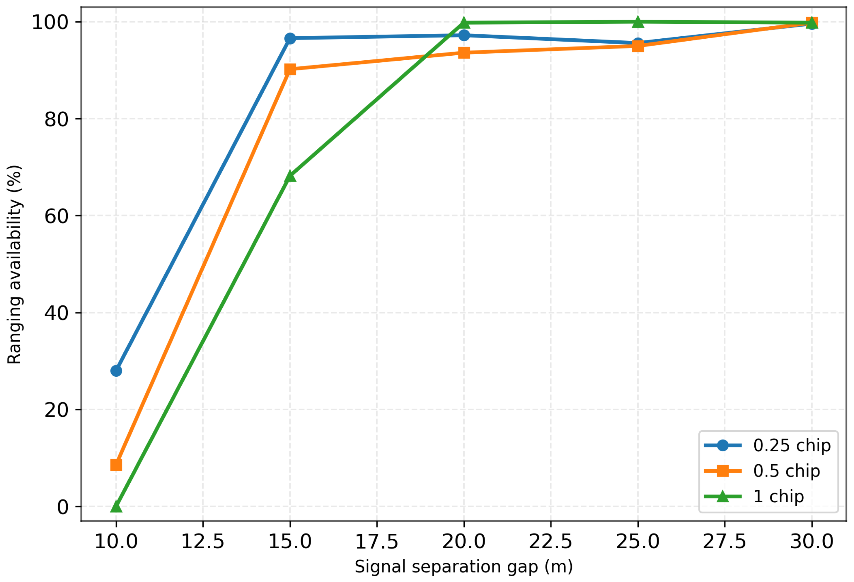
Figure 7 illustrates the statistical detection success probability as a function of the delay separation between the direct and reflected signals under three correlation sampling resolutions (0.25, 0.5, and 1 chip). The detection success probability is defined as the probability that the reflected signal can be successfully separated and yield a valid ranging estimate. Overall, for all resolution settings, the detection success probability generally increases as the delay separation between the signals becomes larger.
In the small-separation regime, the performance differences among the correlation resolutions become particularly pronounced. When the equivalent height separation corresponding to the direct–reflected path difference is approximately 10 m, the detection success probability drops significantly for all resolutions. Under this condition, reliable signal separation is nearly unattainable for the 0.5-chip and 1-chip resolutions, whereas the 0.25-chip resolution still maintains a certain level of detection success probability. This result indicates that a finer correlation sampling resolution improves the capability to resolve closely spaced signal components in the delay domain, thereby mitigating the performance degradation caused by waveform overlap.
When the delay separation exceeds a certain threshold, the detection success probability for all three resolutions approaches 100%, indicating that reliable signal separation can be achieved once waveform overlap becomes sufficiently reduced. It is worth noting that under the 1-chip resolution, fluctuations can still be observed when the equivalent height separation exceeds approximately 15 m. These variations are mainly attributed to increased delay estimation errors introduced by the coarse correlation sampling resolution, which reduces the statistical stability of the ranging results.
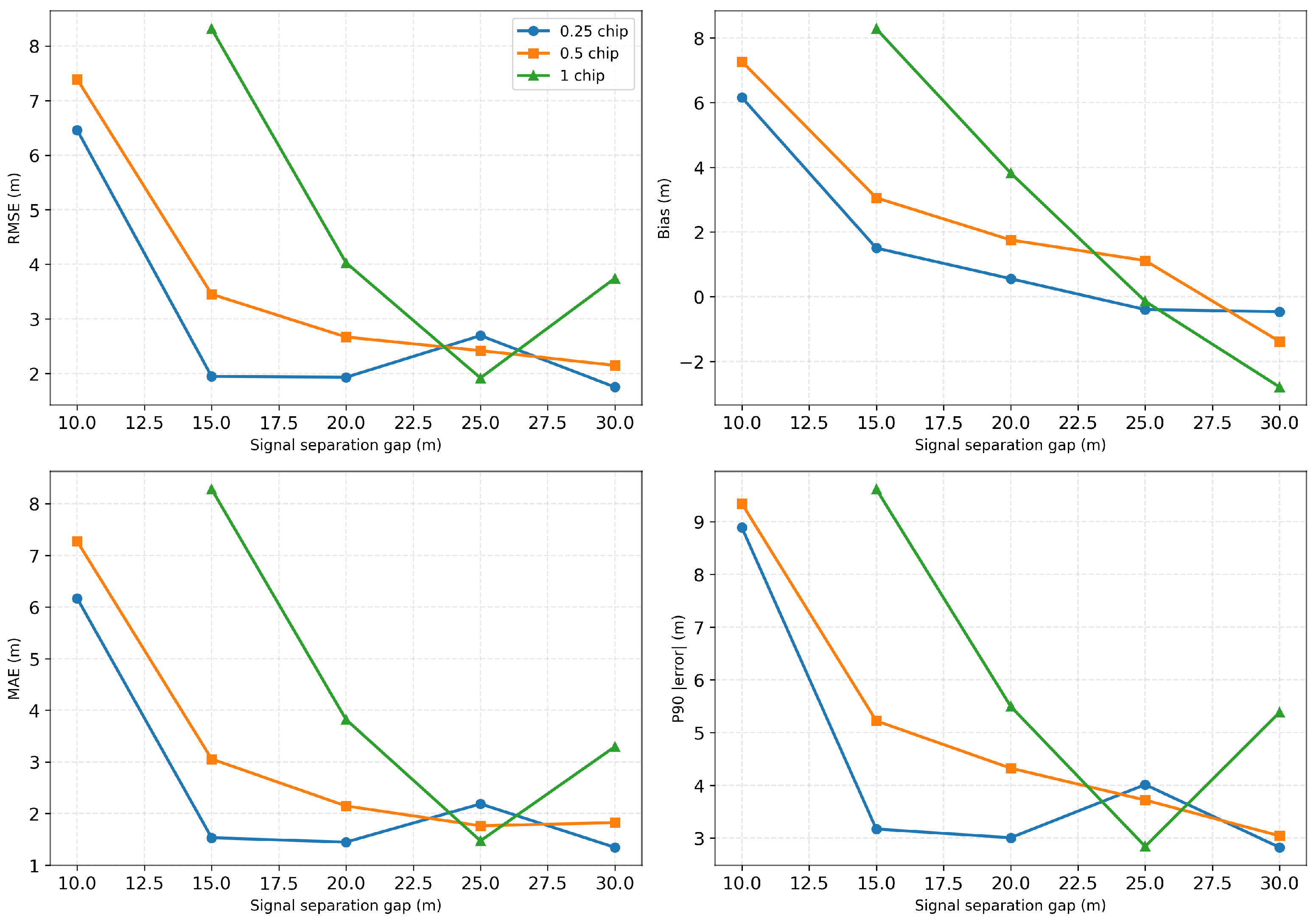
Further analysis of the estimation errors is presented in
Figure 8. To provide a more comprehensive evaluation of the algorithm performance, the statistical assessment is extended beyond the conventional root-mean-square error (RMSE) metric by incorporating additional indicators, including the mean error (Bias), standard deviation (Std), and the 90th percentile error (P90). The Bias reflects the systematic offset of the estimation results, the Std characterizes the random variability of the errors, and the P90 metric describes the upper-bound behavior of the error distribution. Together, these indicators provide a more complete characterization of the robustness of the proposed algorithm under different signal overlap conditions. The detailed statistical results are summarized in
Table 4.
From these statistical metrics, it can be observed that the 0.25-chip resolution achieves the best overall performance among the three correlation resolutions. As the delay separation (gap) between the direct and reflected signals increases, the degree of waveform overlap gradually decreases, and all error metrics show noticeable improvements. This indicates that both the signal separation capability and the ranging accuracy improve as the signals become more separable. The 0.5-chip resolution exhibits a similar trend, with the error metrics gradually decreasing as the gap increases.
In contrast, under the 1-chip resolution, a degradation in estimation accuracy can be observed when the gap exceeds approximately 25 m. This phenomenon is mainly caused by the inherent limitation introduced by the coarse correlation sampling resolution. Since one chip corresponds to approximately 29.3 m in code length, when the true delay separation is smaller than or comparable to this sampling scale, the discretization of the correlation peak may introduce non-negligible estimation errors, thereby affecting the stability and accuracy of the delay estimation. Consequently, under coarse-resolution conditions, the statistical performance may still be constrained by the sampling resolution even when the signal separation becomes larger.
4.2. Performance Evaluation Under Varying Reflected-to-Direct Signal Ratios
A simulation-based Monte Carlo experiment was conducted to assess the impact of reflected-signal strength on the detection performance of the reflected component and the accuracy of height (delay-gap) estimation. In the experiment, the equivalent amplitude of the direct component was fixed at
, and the equivalent signal-to-noise ratio (SNR) in the correlation-waveform domain was maintained at 20 dB. The reflected-signal strength was varied by sweeping the reflected-to-direct amplitude ratio (RDR, in dB). The main simulation parameters are summarized in
Table 5.
In addition, multiple direct–reflected delay separations, corresponding to path-length gaps ranging from 10 to 30 m, were considered to analyze the influence of signal overlap on the separation performance.
For each parameter configuration, N Monte Carlo trials were performed ( in this study). The reflected-signal detection success rate, and the ranging root-mean-square error (RMSE) were computed.
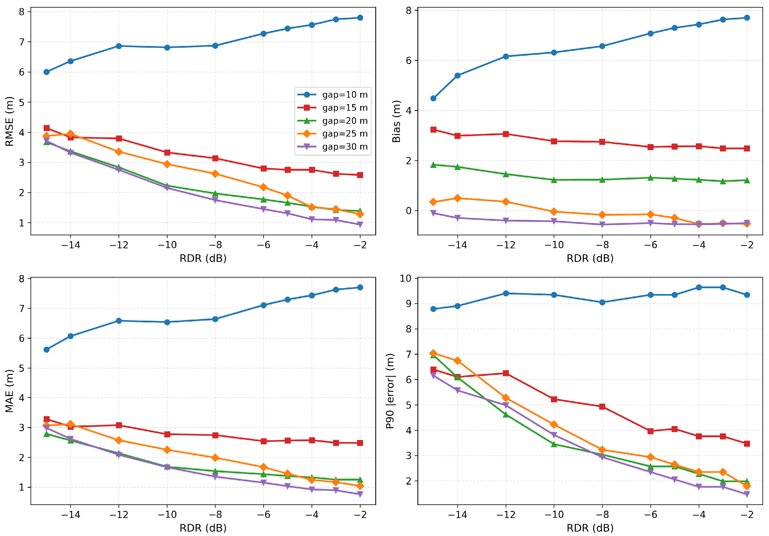
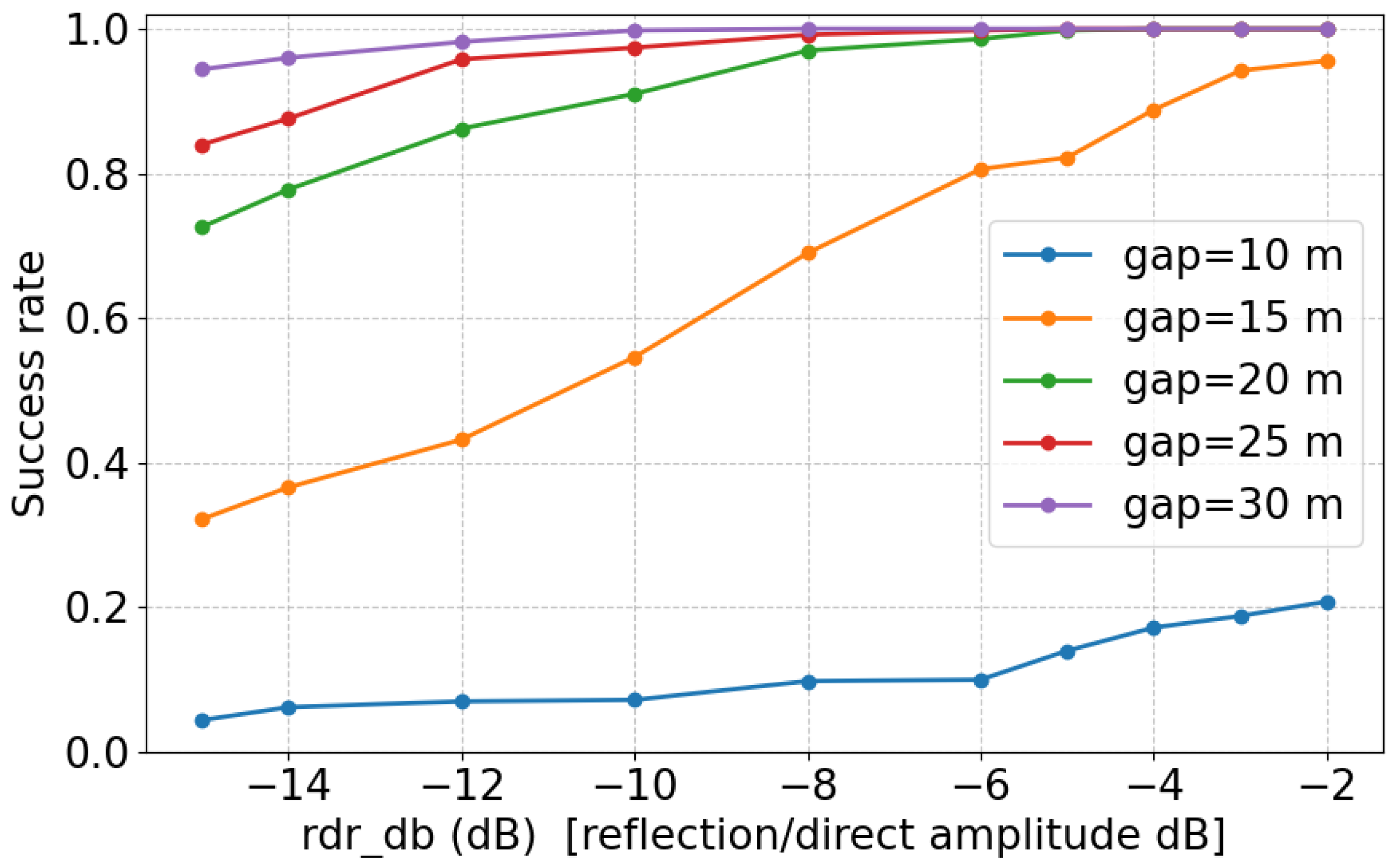
Figure 9 and
Figure 10 summarize the influence of reflected-signal strength on detection performance and ranging accuracy under different direct–reflected delay separations. In addition to the root mean square error (RMSE), the figures also present several statistical evaluation metrics, including the mean error (Bias), standard deviation (Std), and the 90th percentile error (P90), which provide a comprehensive characterization of the ranging error from different statistical perspectives. With the SNR fixed at 20 dB, both the detection success rate and the ranging accuracy generally improve as the reflected-to-direct amplitude ratio increases, and the different statistical metrics exhibit consistent trends.
A notable exception occurs when the equivalent height gap is 10 m. Under this condition, regardless of the reflected-signal strength, the detection success rate as well as all error-related metrics remain significantly inferior to those obtained at larger delay separations. This behavior is consistent with the analysis presented in the previous subsection and can be attributed to severe delay-domain overlap between the direct and reflected signals.
More specifically, when the delay separation is small (corresponding to the 10 m height gap), the correlation responses of the direct and reflected signals become highly correlated, making the separation problem ill-conditioned. Under this strong overlap condition, the composite correlation waveform contains not only the individual signal components but also significant cross-interference terms between them. These cross terms scale with the product of the amplitudes of the direct and reflected signals and, therefore, become more pronounced as the reflected-signal strength increases. Consequently, increasing the reflected-signal strength does not simply improve detectability. Instead, the enhanced cross-interference distorts the symmetry of the composite main lobe and shifts the effective peak location away from the true delay of the direct signal, introducing additional bias in the delay estimation and leading to larger ranging errors under strong overlap conditions. This effect is reflected not only in the RMSE but also consistently in the Bias, Std, and P90 metrics.
Therefore, such strong waveform superposition limits the effective separability of the two signals, thereby constraining both detection reliability and ranging performance. The degradation under this height-gap condition is also clearly reflected in the quantitative results reported in
Table 6 and
Table 7.
For delay separations larger than 10 m, the detection success rate increases monotonically with the reflected-signal strength and approaches unity once the reflected component becomes sufficiently strong. Meanwhile, all error-related statistical metrics improve significantly. As illustrated in
Figure 10, the RMSE, Bias, Std, and P90 all decrease as the reflected-signal strength increases. These results indicate that, outside the regime dominated by strong signal overlap, the reflected-signal strength becomes the primary factor governing the achievable ranging accuracy.
Overall, the results demonstrate that the proposed algorithm can effectively separate the mixed direct and reflected signals. Under favorable delay separation and signal-strength conditions, all statistical metrics remain stable, and the ranging accuracy can reach sub-meter levels, with errors below 1 m.
4.3. Flight-Scenario Simulation Validation Using the SPIRENT 9000 Platform
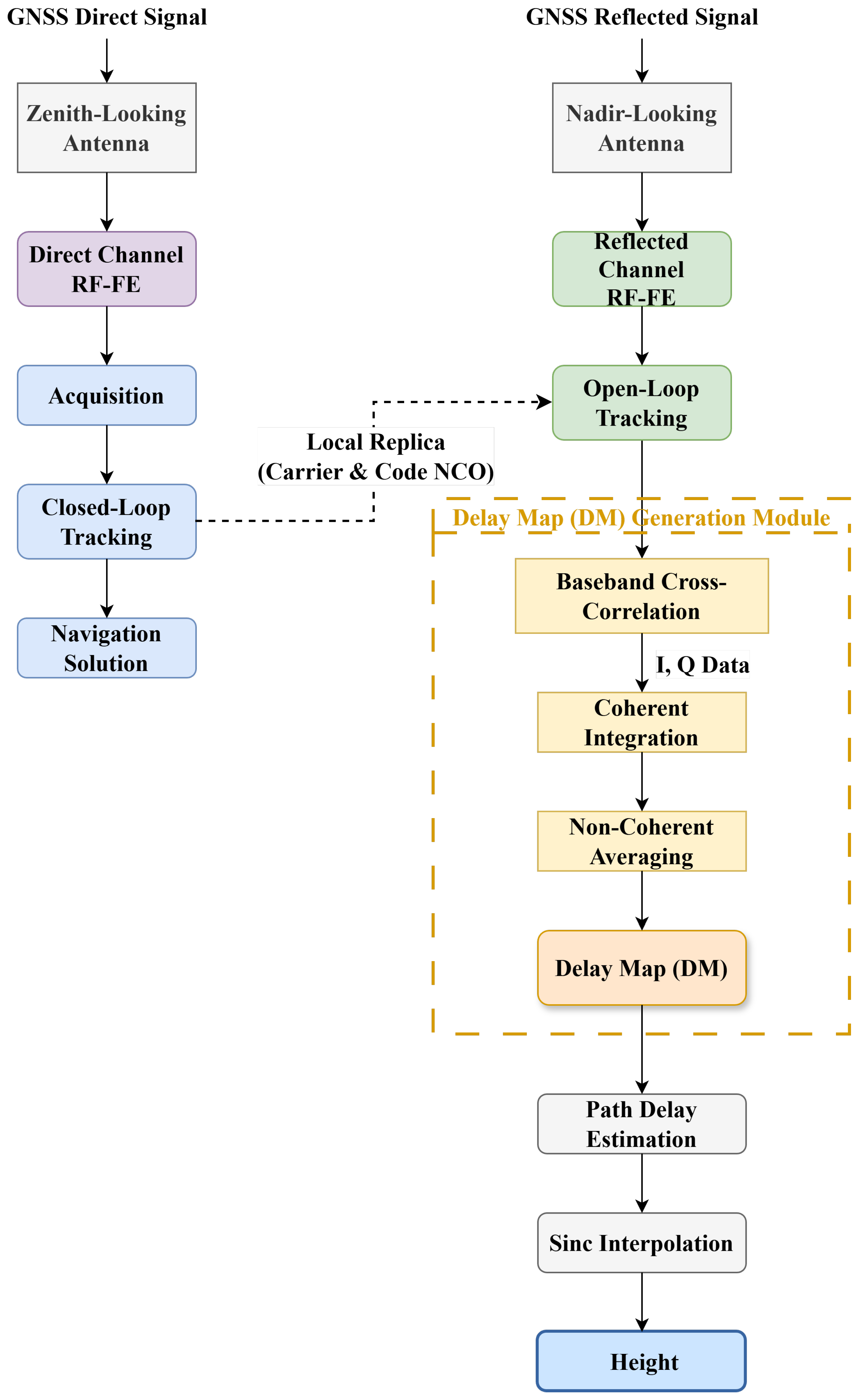
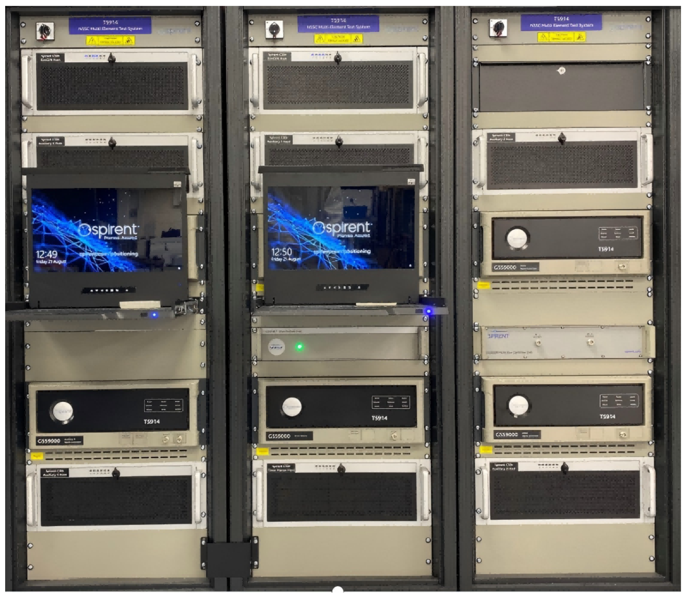
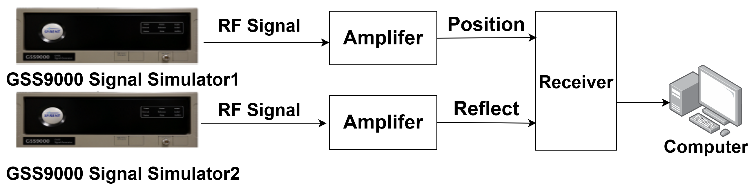
Evaluation of the proposed algorithm under conditions representative of real flight operations was performed by integrating the algorithm into the ARM processor of the self-developed receiver. Experimental scenarios were constructed within the SPIRENT 9000 flight scenario simulator, with testing conducted based on realistic flight geometries. The simulator generates composite signals consisting of direct and reflected components according to true geometric configurations and temporal dynamics, thereby enabling effective emulation of GNSS signal propagation and reflection effects in low-altitude flight environments. Compared with Monte Carlo simulations relying on idealized signal models, this experimental environment more faithfully captures key characteristics, including time-varying path delays, dynamic platform height variations, and the evolution of correlation peak shapes.
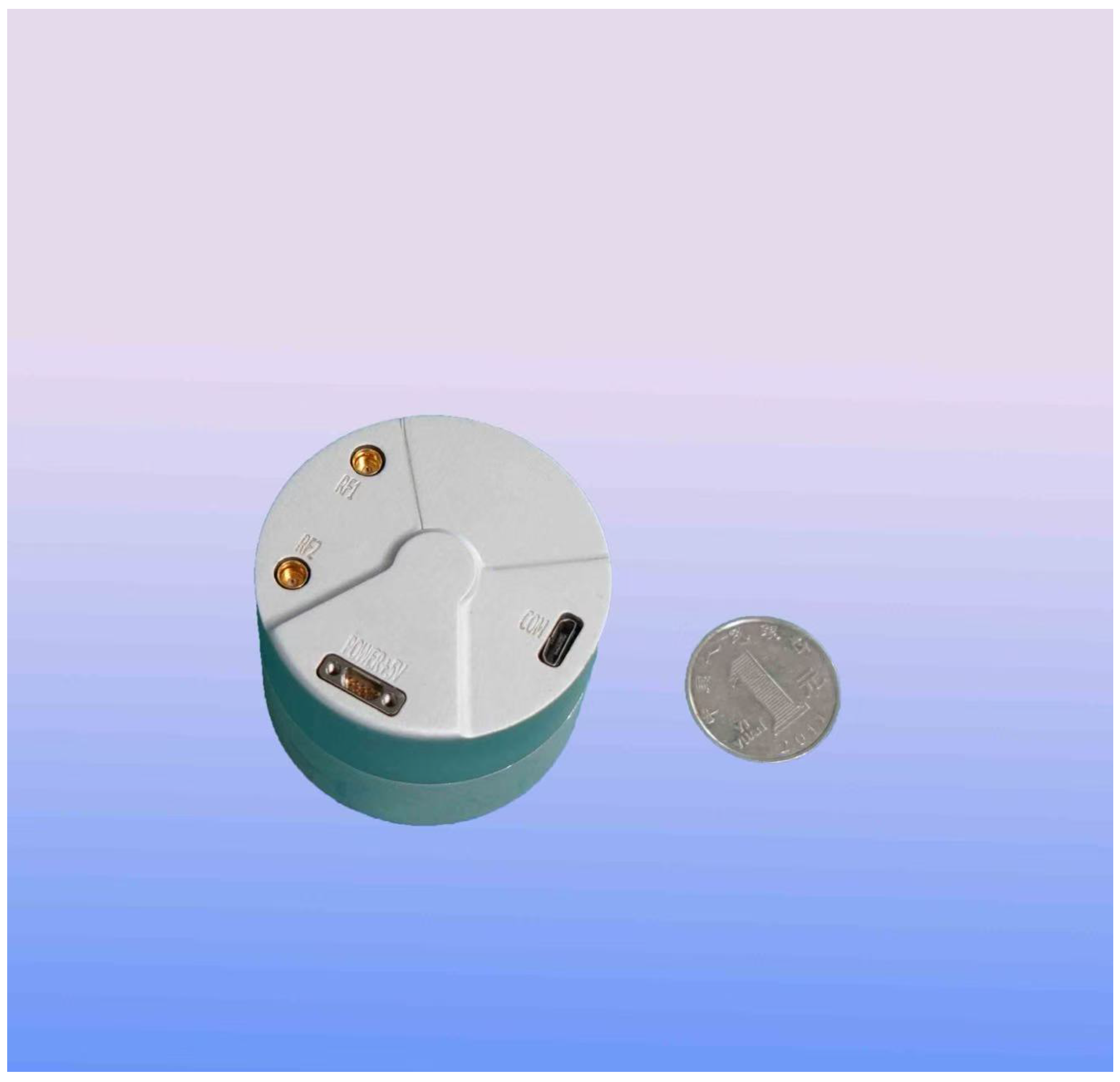
Algorithm validation was carried out using a miniaturized self-developed receiver platform, where the proposed algorithm was implemented on the ARM processor of the receiver for real-time signal processing, allowing system-level assessment under conditions closely aligned with practical engineering implementation. This configuration facilitates observation of waveform superposition phenomena and their dynamic behavior within realistic receiver processing chains in low-altitude flight scenarios.
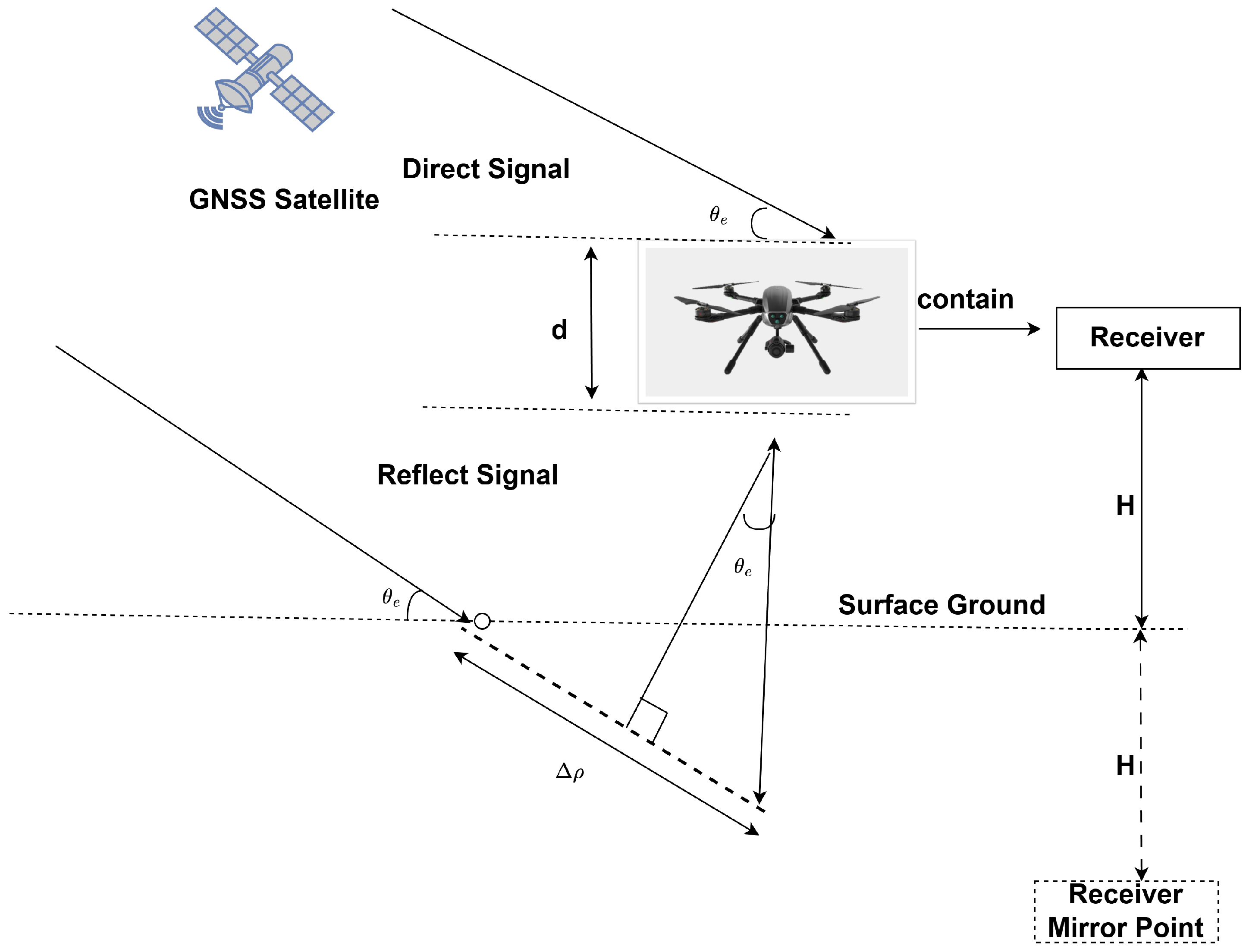
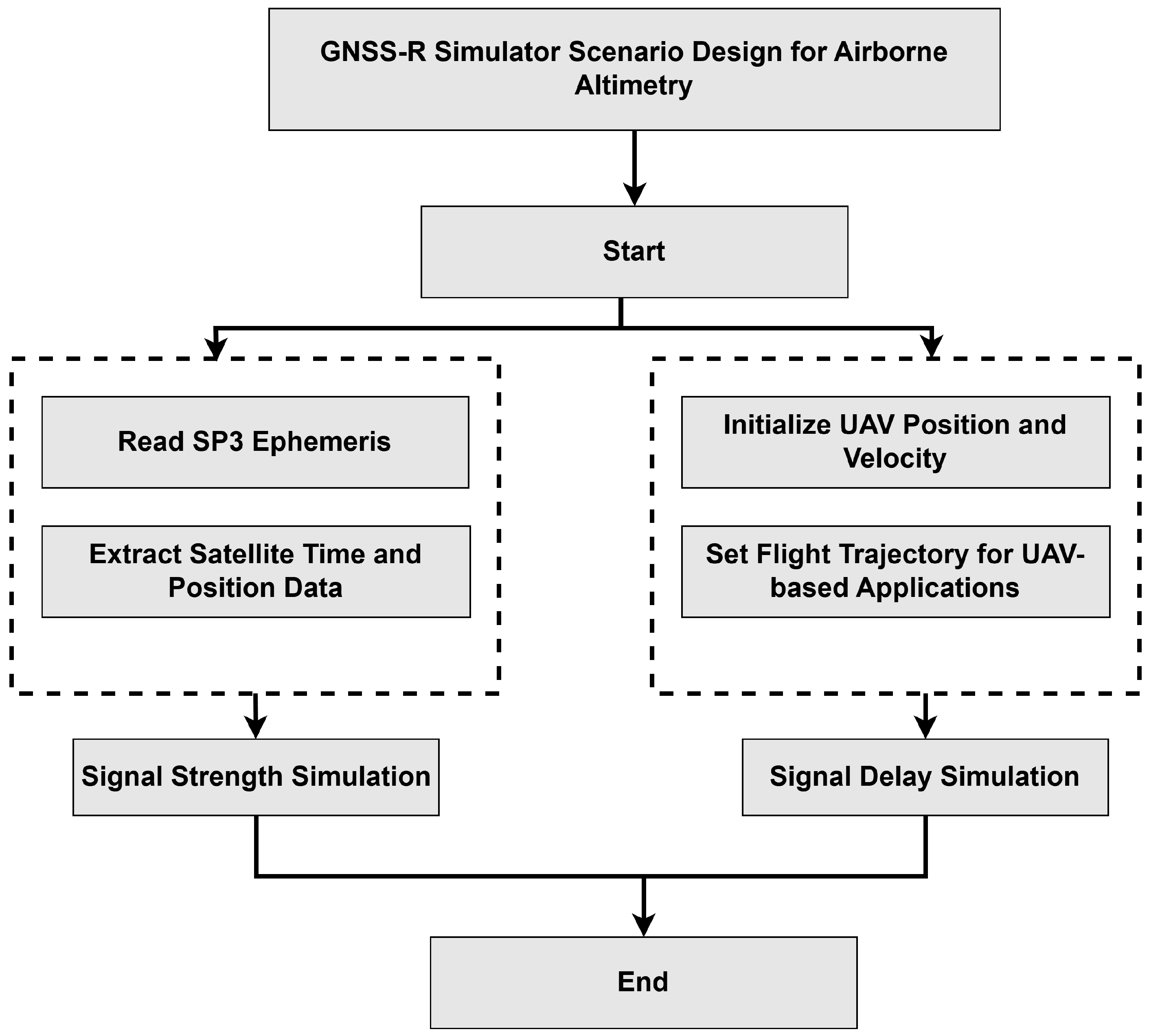
To construct a physically consistent simulation environment, the GNSS-R observation geometry was explicitly modeled within the SPIRENT simulator. Satellite positions were obtained from precise ephemeris data, while the UAV receiver trajectory and motion parameters were predefined to emulate realistic low-altitude flight operations. Based on the transmitter (satellite) and receiver (UAV) positions, the bistatic reflection geometry was established and the specular reflection point was determined accordingly. The corresponding path difference between the direct and reflected signals was computed according to the bistatic geometry model, which directly determined the delay separation between the two signal components. The reflected signal power was also generated based on geometry-dependent propagation conditions.
Within the SPIRENT 9000 simulation environment, three correlation processing resolutions were configured at the receiver ARM processor: 0.25 chip, 0.5 chip, and 1 chip. The simulator produced 12-level DM waveforms for processing. In addition, multiple direct–reflection path separation scenarios were established through the introduction of varying relative delays applied to the reflected signals. Under dynamic conditions, the detection and tracking capabilities of the algorithm with respect to reflected signals were evaluated through analysis of correlation peak separation and their temporal evolution. Ranging accuracy was further examined through quantitative analysis.
For the establishment of standardized and repeatable comparative experiments, benchmark test scenarios were generated via automated inputs driven by the UCD (User Command Definition) command set, as shown in
Figure 11. The UCD command set represents a structured command mechanism designed for describing simulator scenario configurations and signal generation control parameters. Unified definitions of platform motion states, signal propagation conditions, and multipath parameters ensure consistency and reproducibility across different experimental settings. Representative path separations of 10 m, 15 m, and 30 m were selected. Systematic evaluation of signal separation performance under varying correlation resolutions and delay conditions was achieved through comparison between simulator outputs and corresponding benchmark configurations. The operational range and performance limits of the proposed method under realistic flight scenarios were also analyzed.
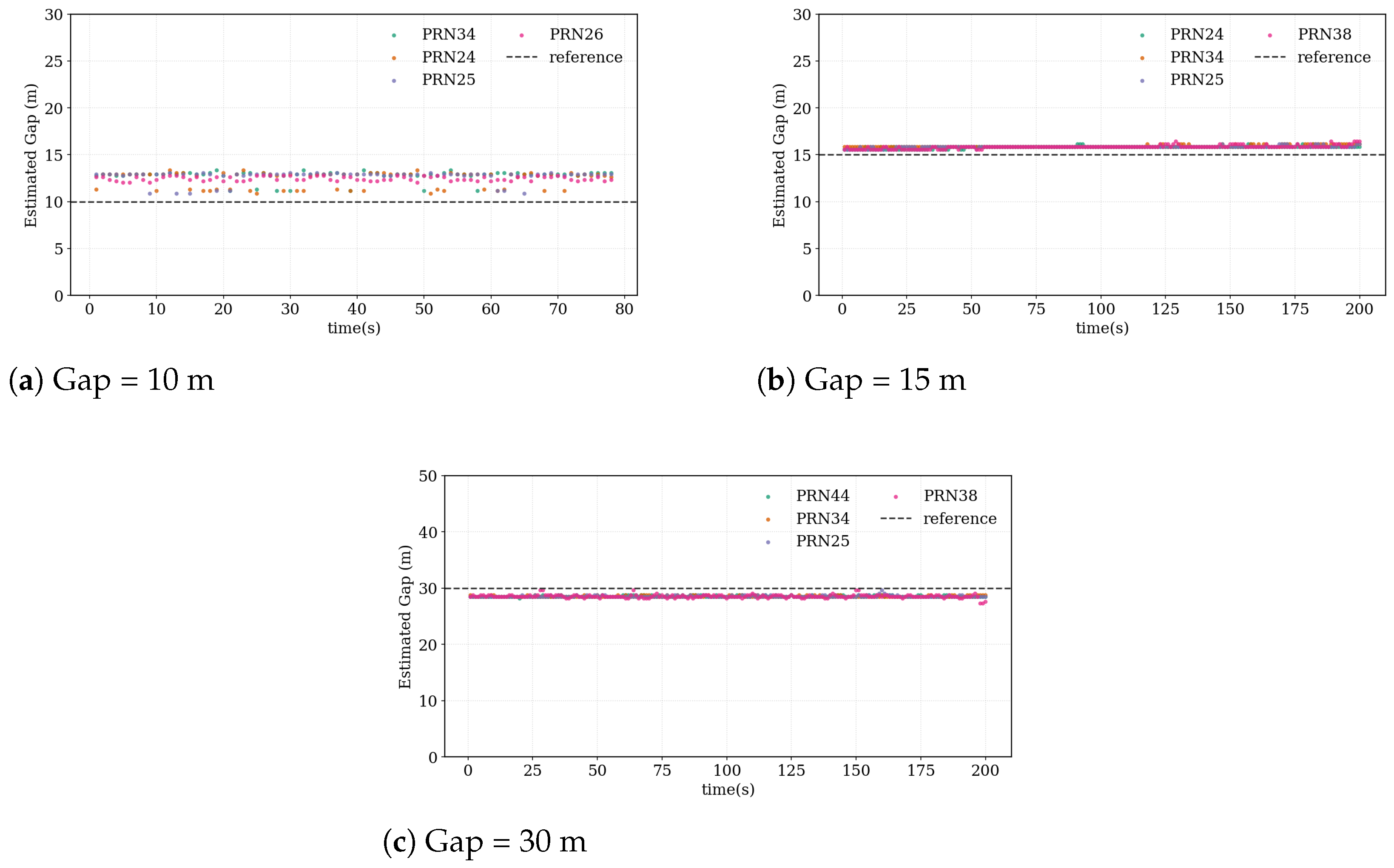
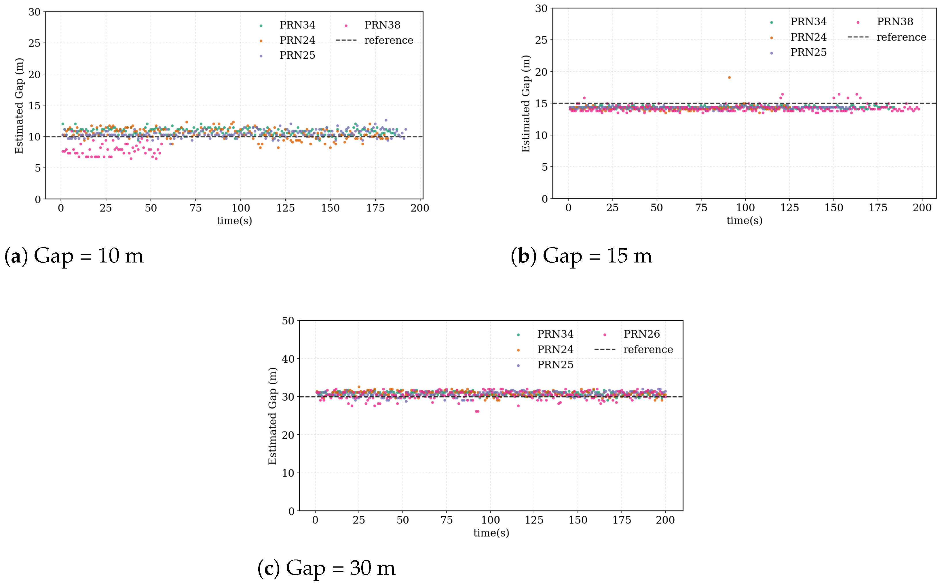
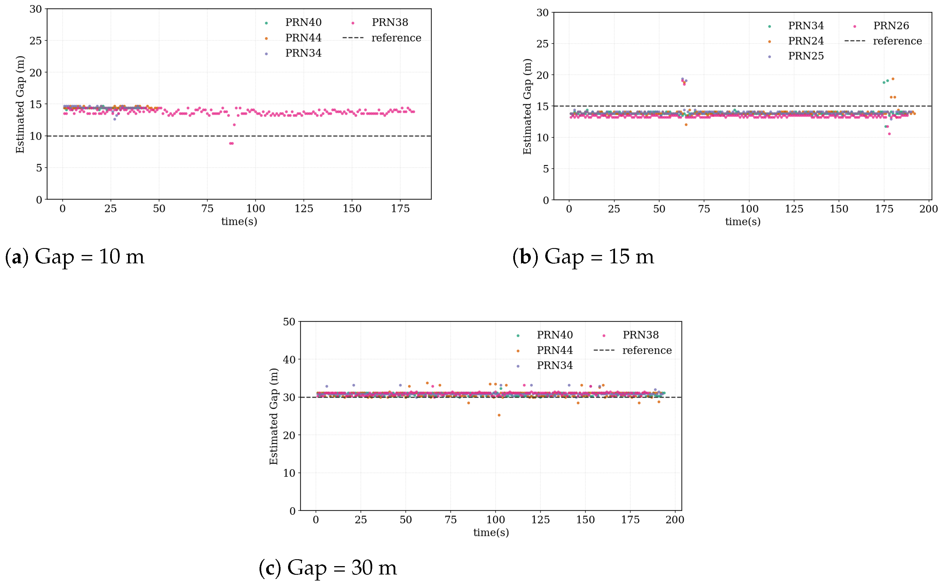
Figure 12,
Figure 13 and
Figure 14 illustrate the estimated direct–reflection path separations obtained during flight scenario simulations when the platform traversed approximately 10 m along its trajectory. Results are presented for correlation resolutions of 0.25 chip, 0.5 chip, and 1 chip. Colored scatter points denote estimates from different PRN satellites, while dashed lines indicate reference path separations. Due to hardware processing constraints of the receiver, only the four satellites with the highest elevation angles were included. Major error sources were analyzed previously, and real-time correction strategies were incorporated within the receiver processing chain. System-level errors introduced by the simulator were calibrated and compensated. Consequently, the reported results primarily reflect the intrinsic performance of the proposed algorithm.
Overall, under dynamic flight conditions, effective detection and separation of reflected signals were achieved across all three correlation resolutions. The estimated path separations from different PRN satellites are generally distributed around the reference values, indicating that the proposed algorithm maintains reliable performance under realistic flight geometries and platform motion dynamics.
Clear performance differences can nevertheless be observed among the three correlation resolutions. Under the 1 chip resolution, the estimates exhibit significant dispersion, with certain PRNs showing consistent deviations relative to the reference values, suggesting the presence of systematic bias.
It should be noted that this bias mainly originates from the coarse discretization of the correlation waveform rather than an intrinsic limitation of the proposed signal separation method. For example, a 10 m path-length gap is observed on a sampling grid with a chip length of approximately 29.3 m. In such cases, when the true path-length gap is smaller than the effective sampling interval, the discretized correlation waveform may introduce a deterministic offset in the estimated peak location. This behavior is mainly attributed to the broader correlation peaks associated with coarse-resolution processing. Although interpolation techniques were applied, the limited effective resolution still introduces non-negligible estimation errors.
When the resolution improves to 0.5 chip, the dispersion level decreases compared with the 1 chip case, and the systematic deviation is partially reduced. Nevertheless, occasional outliers and temporal fluctuations remain, indicating that the overlapping effects between direct and reflected signals are not completely suppressed.
Further improvement is observed at the finest resolution of 0.25 chip. In this case, the estimates from different PRN satellites cluster closely around the reference path separations, accompanied by noticeably enhanced temporal stability. These results indicate that higher-resolution correlation processing more effectively separates the correlation peaks corresponding to direct and reflected signals, thereby reducing both systematic and random errors induced by waveform superposition.
The statistical delay estimation performance summarized in
Table 8 further confirms these observations across different path-length gaps and processing resolutions. Furthermore,
Table 9 presents the corresponding altimetry performance obtained by converting the estimated delay difference into surface height using the bistatic geometric relationship among the satellite, UAV, and specular reflection point.
In summary, within the flight scenario simulation environment, the 0.25 chip resolution demonstrates superior performance in signal separation capability, estimation stability, and cross-PRN consistency. This observation is consistent with the results obtained from the Monte Carlo simulations and further confirms the applicability and engineering feasibility of the proposed algorithm under realistic flight conditions.




 ,
,