Increasing Irrigated Agriculture Area and Its Related Water Consumption Set Djorf Aquifer at Risk of Water Quantity Depletion
 ,
,  ,
, 
Highlights
- Irrigated agriculture in the Djorf coastal zone expanded dramatically from 2005 to 2025, increasing four-fold, and was detected with high accuracy using GIS, remote sensing, and random forest classification.
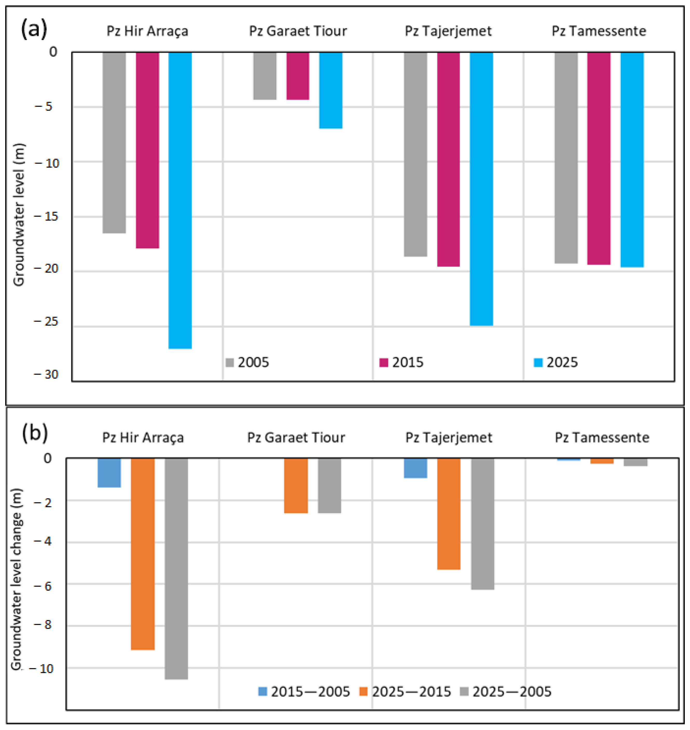
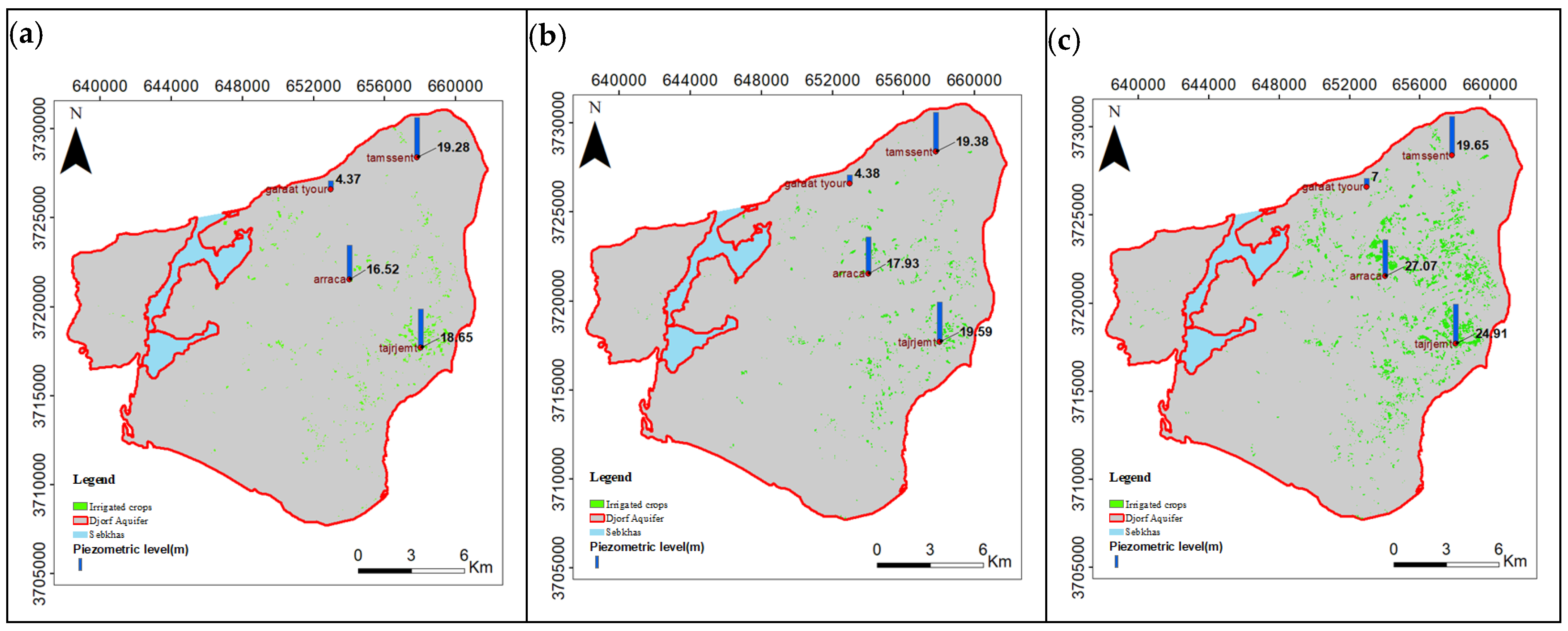
- Groundwater levels in the Djorf aquifer declined significantly across almost all piezometric wells, with the sharpest drops occurring between 2015 and 2025, corresponding to rapid agricultural expansion in central and southern parts of the study area.
- The continued growth of irrigated cropland—despite regulatory restrictions—poses a critical threat to the sustainability of the Djorf aquifer.
- Immediate, evidence-based groundwater management interventions are needed to prevent further depletion in this vulnerable semi-arid coastal region.
Abstract
1. Introduction
2. Materials and Methods
2.1. Study Area
2.2. Data
2.2.1. Earth Observations
2.2.2. Field Data
2.3. Method
Irrigation Area Monitoring
3. Results
3.1. Classification Performance
3.2. Irrigated Area Dynamics
3.3. Impacts of Irrigated Area Expansion on Groundwater Level
3.4. Spatial Heterogeneity vs. System’s Response
4. Discussion
4.1. Accuracy Assessment
4.2. Irrigated Area Mapping
4.3. Groundwater Decline and Spatial Variability
5. Conclusions
Author Contributions
Funding
Data Availability Statement
Acknowledgments
Conflicts of Interest
References
- Sakellariou, S.; Spiliotopoulos, M.; Alpanakis, N.; Faraslis, I.; Sidiropoulos, P.; Tziatzios, G.A.; Karoutsos, G.; Dalezios, N.R.; Dercas, N. Spatiotemporal Drought Assessment Based on Gridded Standardized Precipitation Index (SPI) in Vulnerable Agroecosystems. Sustainability 2024, 16, 1240. [Google Scholar] [CrossRef] [Scilit]
- Ferreira, D.; Simões, M.; Pessoa, M.; Reboredo, F.; Almeida, A.; Lidon, F. Impacts of Irrigated Cultures (Paddy-Rice) in Groundwater Quality in Tejo Alluvial River Basin, Portugal. In Advances in Geoethics and Groundwater Management: Theory and Practice for a Sustainable Development; Springer: Cham, Switzerland, 2021; pp. 263–266. [Google Scholar]
- Liberoff, A.L.; Poca, M. Groundwater-surface water interactions in a semi-arid irrigated agricultural valley: A hydrometric and tracer-aided approach. Sci. Total Environ. 2023, 903, 166625. [Google Scholar] [CrossRef] [Scilit]
- Makhlouf, A.; Sharaan, M.; El-Rawy, M.; Kanae, S.; Ibrahim, M.G. Investigating the effects of surface water recharge on groundwater quality using hydrochemistry and ANFIS model: A case study Minia Governorate, Egypt. J. Environ. Manag. 2024, 362, 121269. [Google Scholar] [CrossRef] [Scilit]
- Ahoton, D.H.; Bacharou, T.; Bossa, A.Y.; Sintondji, L.O.; Bonkoungou, B.; Alofa, V.M. Dynamics of Irrigated Land Expansion in the Ouémé River Basin Using Field and Remote Sensing Data in the Google Earth Engine. Land 2024, 13, 1926. [Google Scholar] [CrossRef] [Scilit]
- Assaoui, N. Use of Remote Sensing and GIS to Study the Evolution of Irrigated Areas and Their Impact on Groundwater in a Semi-Arid Region (Morocco). In Selected Studies in Geotechnics, Geo-Informatics and Remote Sensing; Springer: Cham, Switzerland, 2023; pp. 75–79. [Google Scholar]
- Abuzar, M.; Sheffield, K.; McAllister, A. Feasibility of Using SWIR-Transformed Reflectance (STR) in Place of Surface Temperature (Ts) for the Mapping of Irrigated Landcover. Land 2024, 13, 633. [Google Scholar] [CrossRef] [Scilit]
- Li, W.; Sun, Y.; Zhou, Y.; Gong, L.; Li, Y.; Xin, Q. Mapping Irrigated Croplands from Sentinel-2 Images Using Deep Convolutional Neural Networks. Remote Sens. 2023, 15, 4071. [Google Scholar] [CrossRef] [Scilit]
- Li, Q.; Ouyang, W.; Zhu, J.; Lin, C.; He, M. Discharge dynamics of agricultural diffuse pollution under different rainfall patterns in the middle Yangtze river. J. Environ. Manag. 2023, 347, 119116. [Google Scholar] [CrossRef] [Scilit]
- Yimer, A.K.; Haile, A.T.; Hatiye, S.D.; Ragettli, S.; Taye, M.T. Comparative evaluation of the accuracy of mapping irrigated areas using sentinel 1 images in the Bilate and Gumara watersheds, Ethiopia. Cogent Eng. 2024, 11, 2357728. [Google Scholar] [CrossRef] [Scilit]
- El-bouhalı, A.; Amyay, M.; El Ouazanı Ech-chahdı, K. Detection of irrigated crops using Landsat 8 images: A methodology based on fieldwork and spectral reflectance analysis. Int. J. Eng. Geosci. 2025, 10, 1–13. [Google Scholar] [CrossRef] [Scilit]
- Saquella, S.; Pampanoni, V.; Ferrari, A.; Laneve, G. Detection of Irrigated and Rainfed Crops with Machine Learning Multivariate Time-Series Object-Based Classification Using Sentinel-2 Imagery. In IGARSS 2023 IEEE International Geoscience and Remote Sensing Symposium; IEEE: Piscataway, NJ, USA, 2023. [Google Scholar]
- Tomaz, A.; Martins, I.; Catarino, A.; Mourinha, C.; Dôres, J.; Fabião, M.; Boteta, L.; Coutinho, J.; Patanita, M.; Palma, P. Insights into the Spatial and Temporal Variability of Soil Attributes in Irrigated Farm Fields and Correlations with Management Practices: A Multivariate Statistical Approach. Water 2022, 14, 3216. [Google Scholar] [CrossRef] [Scilit]
- Mekki, I.; Ghazouani, W.; Closas, A.; Molle, F. Perceptions of groundwater degradation and mitigation responses in the Haouaria region in Tunisia. Groundw. Sustain. Dev. 2017, 5, 101–110. [Google Scholar] [CrossRef] [Scilit]
- Elloumi, M. La Gouvernance des Eaux Souterraines en Tunisie; Report No. 6, ‘Groundwater Governance in the Arab World’; IWMI Project Publication: Cairo, Egypt, 2016. [Google Scholar]
- Chebbi, H.E. Agriculture and economic growth in Tunisia. China Agric. Econ. Rev. 2010, 2, 63–78. [Google Scholar] [CrossRef] [Scilit]
- World Bank. Tunisia Agricultural Policy Review; The World Bank: Washington, DC, USA, 2006. [Google Scholar]
- Trabelsi, R.; Abid, K.; Zouari, K.; Yahyaoui, H. Groundwater salinization processes in shallow coastal aquifer of Djeffara plain of Medenine, Southeastern Tunisia. Environ. Earth Sci. 2011, 66, 641–653. [Google Scholar] [CrossRef] [Scilit]
- Agoubi, B.; Kharroubi, A.; Abida, H. Saltwater intrusion modelling in Jorf coastal aquifer, South-eastern Tunisia: Geochemical, geoelectrical and geostatistical application. Hydrol. Process. 2012, 27, 1191–1199. [Google Scholar] [CrossRef] [Scilit]
- Zouari, K.; Trabelsi, R.; Chkir, N. Using geochemical indicators to investigate groundwater mixing and residence time in the aquifer system of Djeffara of Medenine (southeastern Tunisia). Hydrogeol. J. 2010, 19, 209–219. [Google Scholar] [CrossRef] [Scilit]
- Ayed, B.; Khlif, N.; Bouri, S. Groundwater potential recharge assessment in arid regions using GIS tool: Case of the Medenine shallow aquifer (Southeastern Tunisia). Appl. Geomat. 2022, 14, 475–490. [Google Scholar] [CrossRef] [Scilit]
- Bouaziz, S.; Jedoui, Y.; Barrier, É.; Angelier, J. Néotectonique affectant les dépôts marins tyrrhéniens du littoral sud-est tunisien: Implications pour les variations du niveau marin. Comptes Rendus Geosci. 2003, 335, 247–254. [Google Scholar] [CrossRef] [Scilit]
- Jedoui, Y.; Davaud, E.; Ben Ismaïl, H.; Reyss, J.-L. Analyse sédimentologique des dépôts marins pléistocènes du Sud-Est tunisien: Mise en évidence de deux périodes de haut niveau marin pendant le sous-stade isotopique marin 5e (Eémien, Tyrrhénien). Bull. Soc. Géol 2002, 173, 255–264. [Google Scholar] [CrossRef] [Scilit]
- Vermote, E.F.; Roger, J.-C.; Franch, B.; Skakun, S. LaSRC (Land Surface Reflectance Code): Overview, application and validation using MODIS, VIIRS, LANDSAT and Sentinel 2 data’s. In IGARSS 2018 IEEE International Geoscience and Remote Sensing Symposium; IEEE: Piscataway, NJ, USA, 2018; pp. 8173–8176. [Google Scholar]
- Schmidt, G.; Jenkerson, C.; Masek, J.; Vermote, E.; Gao, F. Landsat Ecosystem Disturbance Adaptive Processing System (LEDAPS) Algorithm Description; 2013-1057; U.S. Geological Survey: Reston, VA, USA, 2013; p. 27. [Google Scholar]
- Yang, X.; Xiao, X.; Qin, Y.; Wang, J.; Neal, K. Mapping forest in the southern Great Plains with ALOS-2 PALSAR-2 and Landsat 7/8 data. Int. J. Appl. Earth Obs. Geoinf. 2021, 104, 102578. [Google Scholar] [CrossRef] [Scilit]
- Gorelick, N.; Hancher, M.; Dixon, M.; Ilyushchenko, S.; Thau, D.; Moore, R. Google Earth Engine: Planetary-scale geospatial analysis for everyone. Remote Sens. Environ. 2017, 202, 18–27. [Google Scholar] [CrossRef] [Scilit]
- Sangeetham, R.S.N. A Review on Google Earth Engine: An Open Access Cloud Analysis Platform for Planetary Scale Satellite Data. In E3S Web of Conferences; EDP Sciences: Les Ulis, France, 2024; p. 591. [Google Scholar] [CrossRef] [Scilit]
- Basheer, S.; Wang, X.; Farooque, A.A.; Nawaz, R.A.; Liu, K.; Adekanmbi, T.; Liu, S. Comparison of Land Use Land Cover Classifiers Using Different Satellite Imagery and Machine Learning Techniques. Remote Sens. 2022, 14, 4978. [Google Scholar] [CrossRef] [Scilit]
- Rouse, J.; Haas, R.; Schell, J.; Deering, D. Monitoring Vegetation Systems in the Great Plains with ERTS. In Proceedings of the Earth Resources Technology Satellite Symposium; NASA: Washington, DC, USA, 1973; Volume 1, pp. 309–317. [Google Scholar]
- Lykhovyd, P.; Vozhehova, R.; Hranovska, L.; Bidnyna, I. The link between the normalized difference vegetation index in major crops and meteorological factors. Agrology 2024, 7, 39–45. [Google Scholar] [CrossRef] [Scilit]
- Huete, A.R. A soil-adjusted vegetation index (SAVI). Remote Sens. Environ. 1988, 25, 295–309. [Google Scholar] [CrossRef] [Scilit]
- Novando, G.; Arif, D. Comparison of soil adjusted vegetation index (SAVI) and modified soil adjusted vegetation index (MSAVI) methods to view vegetation density in Padang city using landsat 8 image. Int. Remote Sens. Appl. J. 2023, 2, 31–36. [Google Scholar] [CrossRef] [Scilit]
- Ali, A.S.; Hallett, S.H.; Brewer, T.R. Using vegetation indices for the estimation and production ofvegetation cover maps inthe Jeffara Plain, Libya. IOSR J. Environ. Sci. Toxicol. Food Technol. (IOSR-JESTFT) 2018, 12, 23–28. [Google Scholar]
- Zhen, Z.; Chen, S.; Yin, T.; Chavanon, E.; Lauret, N.; Guilleux, J.; Henke, M.; Qin, W.; Cao, L.; Li, J.; et al. Using the Negative Soil Adjustment Factor of Soil Adjusted Vegetation Index (SAVI) to Resist Saturation Effects and Estimate Leaf Area Index (LAI) in Dense Vegetation Areas. Sensors 2021, 21, 2115. [Google Scholar] [CrossRef] [Scilit]
- Rock, B.; Vogelmann, J.; Vogelmann, A.; Hoshizaki, T.; Williams, D. Remote Detection of Forest Damage. BioScience 1986, 36, 439–445. [Google Scholar] [CrossRef] [Scilit]
- Gao, B.-c. NDWI—A normalized difference water index for remote sensing of vegetation liquid water from space. Remote Sens. Environ. 1996, 58, 257–266. [Google Scholar] [CrossRef] [Scilit]
- Zhao, H.; Di, L.; Sun, Z.; Hao, P.; Yu, E.; Zhang, C.; Lin, L. Impacts of Soil Moisture on Crop Health: A Remote Sensing Perspective. In 2021 9th International Conference on Agro-Geoinformatics (Agro-Geoinformatics); IEEE: Piscataway, NJ, USA, 2021; pp. 1–4. [Google Scholar]
- Lee, H.; Lee, C.; Woo, H.; Choi, S.-E. Optimal Training Sample Sizes for U-Net-Based Tree Species Classification with Sentinel-2 Imagery. Forests 2025, 16, 1718. [Google Scholar] [CrossRef] [Scilit]
- Mohammed, M.; Birhanu, B.; Abegaz, F. Multi-spectral remote sensing for current irrigated area mapping of the Rift Valley Lakes Basin in Ethiopia. AQUA—Water Infrastruct. Ecosyst. Soc. 2023, 72, 2396–2407. [Google Scholar] [CrossRef] [Scilit]
- Benkesmia, Y.; Bentekhici, N. Monitoring the dynamics of irrigated parcels and impacts on phreatic water quality in the Mostaganem Plateau (northwestern Algeria): An integrated analysis using remote sensing and field data for 2010 and 2020. Env. Monit Assess 2025, 197, 898. [Google Scholar] [CrossRef] [Scilit]
- Mishra, V.K.; Awasthi, M.K.; Kumar, L.; Sharma, S.K. Integrating Remote Sensing and GIS for Irrigated Area Mapping in the Betwa River Basin, India. J. Sci. Res. Rep. 2025, 31, 709–721. [Google Scholar] [CrossRef] [Scilit]
- Sarvia, F.; Farren, K.; Khatteli, A.; Chiozza, F.; Maki, A.; Cherif, I.; Mushtaq, F.; Jalal, R.; Henry, M. Mapping Land Cover in Tunisia. In the Context of the Soil Land and Water Digital Information System Initiative; Food and Agriculture Organization of the United Nations: Rome, Italy, 2024. [Google Scholar]
- Zhu, W.; Dönmez, E.; Storm, H.; Heckelei, T.; Siebert, S. Large-scale irrigation area mapping: Status and challenges. Agric. Water Manag. 2026, 323, 110037. [Google Scholar] [CrossRef] [Scilit]
- Tian, F.; Wu, B.; Zeng, H.; Zhang, M.; Zhu, W.; Yan, N.; Lu, Y.; Li, Y. GMIE: A global maximum irrigation extent and central pivot irrigation system dataset derived via irrigation performance during drought stress and deep learning methods. Earth Syst. Sci. Data 2025, 17, 855–880. [Google Scholar] [CrossRef] [Scilit]
- López-Pérez, E.; Sanchis-Ibor, C.; Jiménez-Bello, M.Á.; Pulido-Velazquez, M. Mapping of irrigated vineyard areas through the use of machine learning techniques and remote sensing. Agric. Water Manag. 2024, 302, 108988. [Google Scholar] [CrossRef] [Scilit]
- Rodríguez-Caballero, E.; Cantón, Y.; Moussa, M.; Solé-Benet, A. Irrigated land expansion since 1985 in Southern Tunisia. J. Afr. Earth Sci. 2017, 129, 146–152. [Google Scholar] [CrossRef] [Scilit]
- Mekki, I.; Ferchichi, I.; Taouajouti, N.; Zairi, A. Oasis extension trajectories in Kebili territory, southern Tunisia: Drivers of development and actors’ discourse. New Medit 2022, 21, 85–101. [Google Scholar] [CrossRef] [Scilit]
- Kharroubi, A.; Farhat, S.; Agoubi, B.; Lakhbir, Z. Assessment of water qualities and evidence of seawater intrusion in a deep confined aquifer: Case of the coastal Djeffara aquifer (Southern Tunisia). J. Water Supply Res. Technol.-Aqua 2014, 63, 76–84. [Google Scholar] [CrossRef] [Scilit]
- Famiglietti, J.S. The global groundwater crisis. Nat. Clim. Change 2014, 4, 945–948. [Google Scholar] [CrossRef] [Scilit]



| Satellite Data | ||||
|---|---|---|---|---|
| Landsat5 | Landsat8 | Sentinel2 | Description | |
| Period | June to August 2005 | June to August 2015 and 2025 | August and September 2015 and 2025 | |
| Spatial resolution | 30 m | 30 m | 10 m | |
| Bands | B1 | B2 | B2 | Blue |
| B2 | B3 | B3 | Green | |
| B3 | B4 | B4 | Red | |
| B4 | B5 | B8 | Near infrared (NIR) | |
| B5 | B6 | B11 | Shortwave infrared 1 (SWIR1) | |
| B7 | B7 | B12 | Shortwave infrared 2 (SWIR2) | |
| Spectral indices | Description | Data Source Description | Source |
|---|---|---|---|
| Groundwater level | 2005, 2015 and 2025 | 4 control wells | CRDA Medenine Water Resources Department |
| Irrigated agriculture | 2005 | 120 | CRDA Medenine Department of Statistics |
| 2015 | 120 | ||
| 2025 | 120 | ||
| Other land cover | 2005 | 120 | |
| 2015 | 120 | ||
| 2025 | 120 |
| Spectral Indices | Description | Equation |
|---|---|---|
| NDVI | Normalized Difference Vegetation Index | NIR − Red/NIR + Red |
| SAVI | Soil-Adjusted Vegetation Index | 1.5x (NIR − Red)/(NIR + Red + 0.5) |
| NDWI | Normalized Difference Water Index | NIR − SWIR1/NIR + SWIR1 |
| MSI | Moisture Stress Index | SWIR1/NIR |
| Data | Metrics | 2005 | 2015 | 2025 | Overall |
|---|---|---|---|---|---|
| Landsat | Accuracy | 0.996 | 0.998 | 0.997 | 0.997 |
| Kappa coefficient | 0.726 | 0.949 | 0.890 | 0.855 | |
| Sentinel | Accuracy | 0.995 | 0.997 | 0.996 | |
| Kappa coefficient | 0.823 | 0.897 | 0.860 |
| Satellite Data | Area | 2005 | 2015 | 2025 |
|---|---|---|---|---|
| Landsat | pixel | 4438 | 5496 | 17,746 |
| m2 | 3,994,200 | 4,946,400 | 15,971,400 | |
| ha | 399.42 | 494.64 | 1597.14 | |
| Sentinel | pixel | 76,344 | 151,668 | |
| m2 | 7,634,400 | 15,166,800 | ||
| ha | 763.44 | 1516.68 | ||
| Difference between Sentinel and Landsat (ha) | 268.8 | −80.46 | ||
| Year | 2005 | 2015 | 2025 |
|---|---|---|---|
| Irrigated area (ha) | 399.42 | 494.64 | 1597.14 |
| 2015–2005 | 2025–2015 | 2025–2005 | |
| Irrigated area change (ha) | 95.22 | 1102.5 | 1197.72 |
Disclaimer/Publisher’s Note: The statements, opinions and data contained in all publications are solely those of the individual author(s) and contributor(s) and not of MDPI and/or the editor(s). MDPI and/or the editor(s) disclaim responsibility for any injury to people or property resulting from any ideas, methods, instructions or products referred to in the content. |
© 2026 by the authors. Licensee MDPI, Basel, Switzerland. This article is an open access article distributed under the terms and conditions of the Creative Commons Attribution (CC BY) license.
Share and Cite
Bennour, A.; Bachagha, N.; Atawa, M.; Hamdi, A.; Ouessar, M. Increasing Irrigated Agriculture Area and Its Related Water Consumption Set Djorf Aquifer at Risk of Water Quantity Depletion. Remote Sens. 2026, 18, 708. https://doi.org/10.3390/rs18050708
Bennour A, Bachagha N, Atawa M, Hamdi A, Ouessar M. Increasing Irrigated Agriculture Area and Its Related Water Consumption Set Djorf Aquifer at Risk of Water Quantity Depletion. Remote Sensing. 2026; 18(5):708. https://doi.org/10.3390/rs18050708
Chicago/Turabian StyleBennour, Ali, Nabil Bachagha, Mohamed Atawa, Abdessattar Hamdi, and Mohamed Ouessar. 2026. "Increasing Irrigated Agriculture Area and Its Related Water Consumption Set Djorf Aquifer at Risk of Water Quantity Depletion" Remote Sensing 18, no. 5: 708. https://doi.org/10.3390/rs18050708
APA StyleBennour, A., Bachagha, N., Atawa, M., Hamdi, A., & Ouessar, M. (2026). Increasing Irrigated Agriculture Area and Its Related Water Consumption Set Djorf Aquifer at Risk of Water Quantity Depletion. Remote Sensing, 18(5), 708. https://doi.org/10.3390/rs18050708