Forest Age Estimation by Integrating Tree Species Identity and Multi-Source Remote Sensing: Validating Heterogeneous Growth Patterns Through the Plant Economic Spectrum Theory

 and
and
Highlights
- A tandem remote sensing framework that integrates species classification and species-aware growth modeling achieves a substantial improvement in plantation age estimation accuracy (R2 increased from 0.62 to 0.84).
- It provides direct empirical evidence that the Plant Economic Spectrum theory is traceable in remote sensing data, with species’ functional traits driving distinct age–feature relationships.
- The framework shows high operational robustness (error propagation coefficient γ = 0.23), demonstrating its feasibility for large-scale mapping despite classification uncertainties.
- This species-informed methodology establishes a reliable basis for enhancing the accuracy of plantation carbon sink quantification and enables precision forest management.
Abstract
1. Introduction
2. Data and Methods
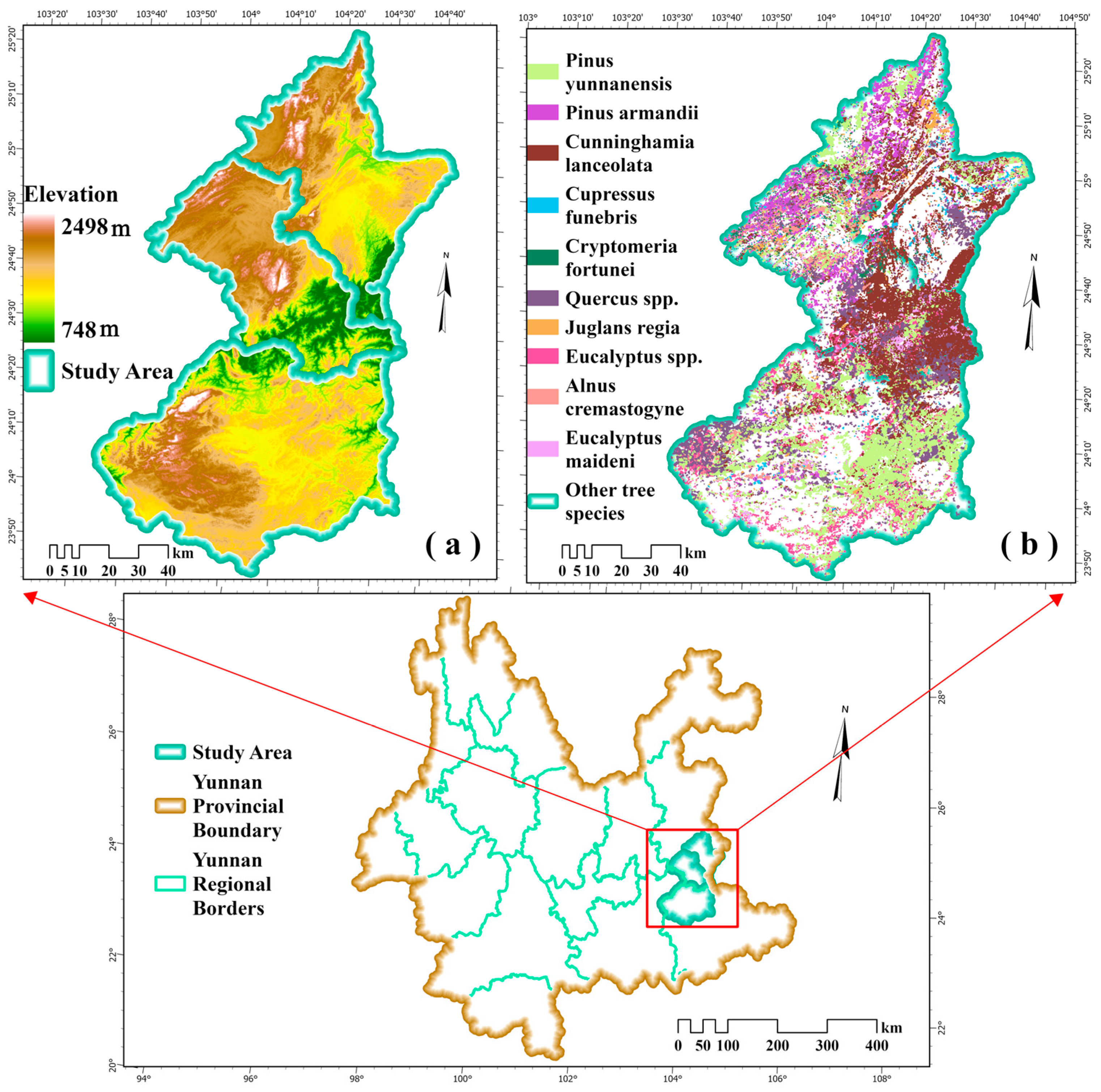
2.1. Study Area
2.2. Data
2.2.1. Remote Sensing Data
2.2.2. Sample Data
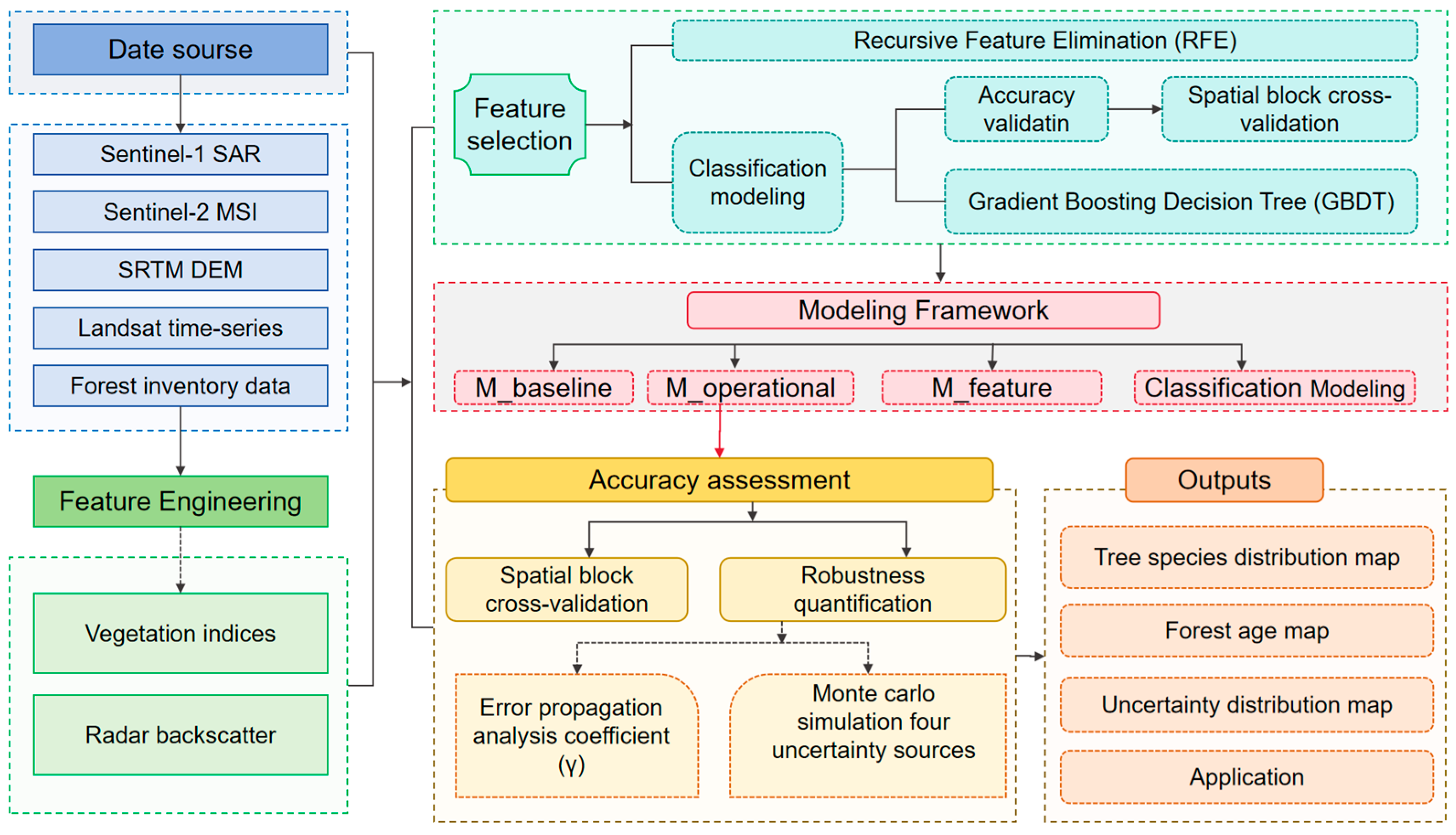
2.3. Methods
- (1)
- An automated data preprocessing module that leverages the GEE platform for streamlined handling of multi-source data.
- (2)
- A high-precision tree species identification module that employs a Gradient Boosting Decision Tree (GBDT) algorithm to integrate multi-dimensional features from optical, radar, and topographic data.
- (3)
- A precise forest age estimation module that constructs a system of species-specific growth parameters for developing differentiated estimation models.
- (4)
- A data output and validation module responsible for generating age distribution products and conducting systematic accuracy assessments.
2.3.1. Tree Species Classification
2.3.2. Forest Age Estimation Model
- (1)
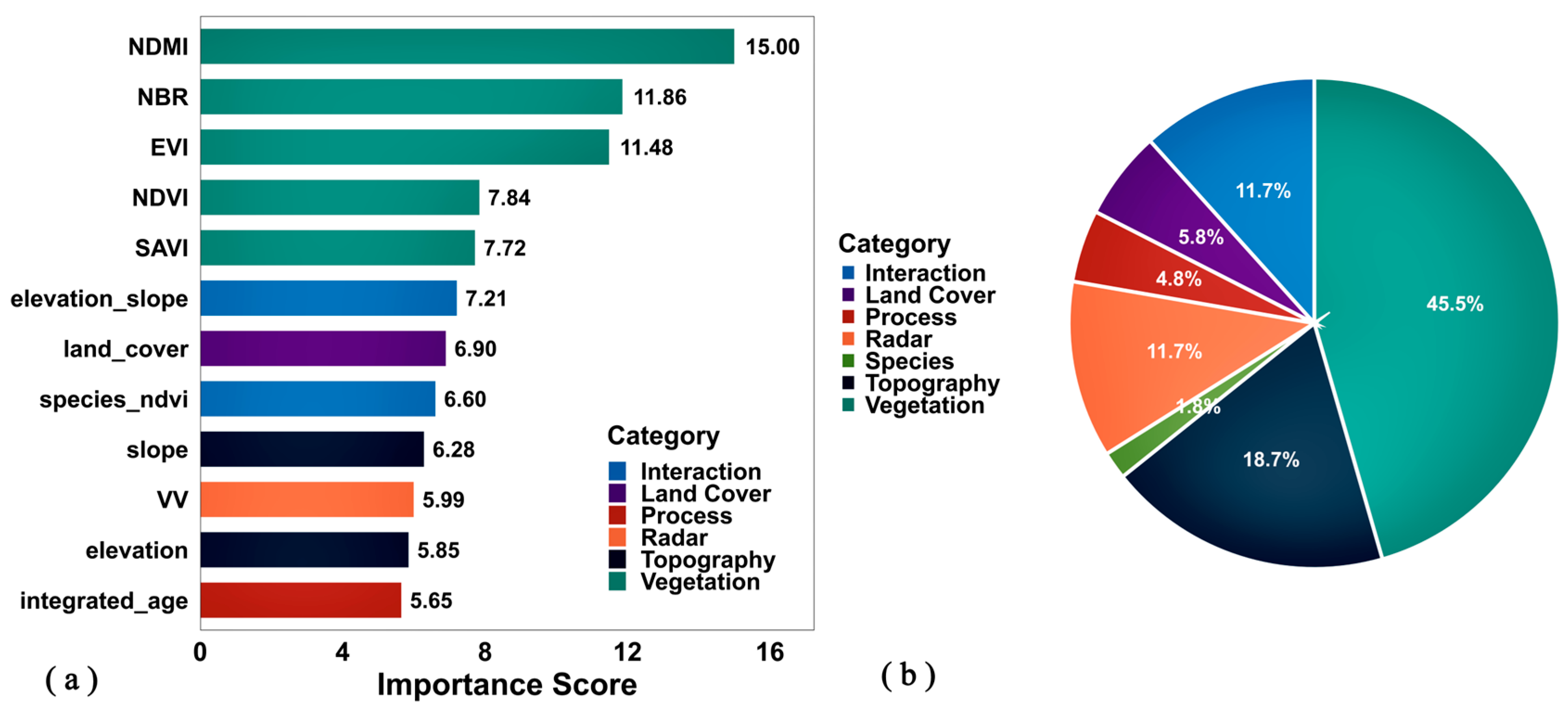
- M_baseline (Baseline Model): A Random Forest regressor using 12 multi-source remote sensing features—five vegetation indices (Normalized Difference Vegetation Index, NDVI; Enhanced Vegetation Index, EVI; Normalized Difference Moisture Index, NDMI; Normalized Burn Ratio, NBR; Soil Adjusted Vegetation Index, SAVI), three radar features (vertical transmit/vertical receive backscatter, VV; vertical transmit/horizontal receive backscatter, VH; Radar Vegetation Index, RVI) and four topographic features (elevation, slope, aspect, Topographic Position Index, TPI)—establishing a unified age–remote sensing relationship without species differentiation.
- (2)
- M_feature (Feature Selection Model): Extending M_baseline by incorporating Boruta algorithm for feature selection, evaluating the contribution of feature optimization to model performance.
- (3)
- M_operational (Operational Model): The primary model employing a unified Random Forest framework, with its core innovation being the incorporation of species probability distributions from the front-end classifier as continuous features. These species’ probability distributions were then combined with the 12 multi-source features, resulting in a 15-dimensional input vector for the Random Forest regressor. Using probabilistic outputs rather than hard classification provides richer, continuous species identity information, enabling the model to learn transitional characteristics and uncertainties between species, thereby enhancing estimation accuracy and robustness.
2.3.3. Accuracy Assessment and Uncertainty Analysis
3. Results and Analysis
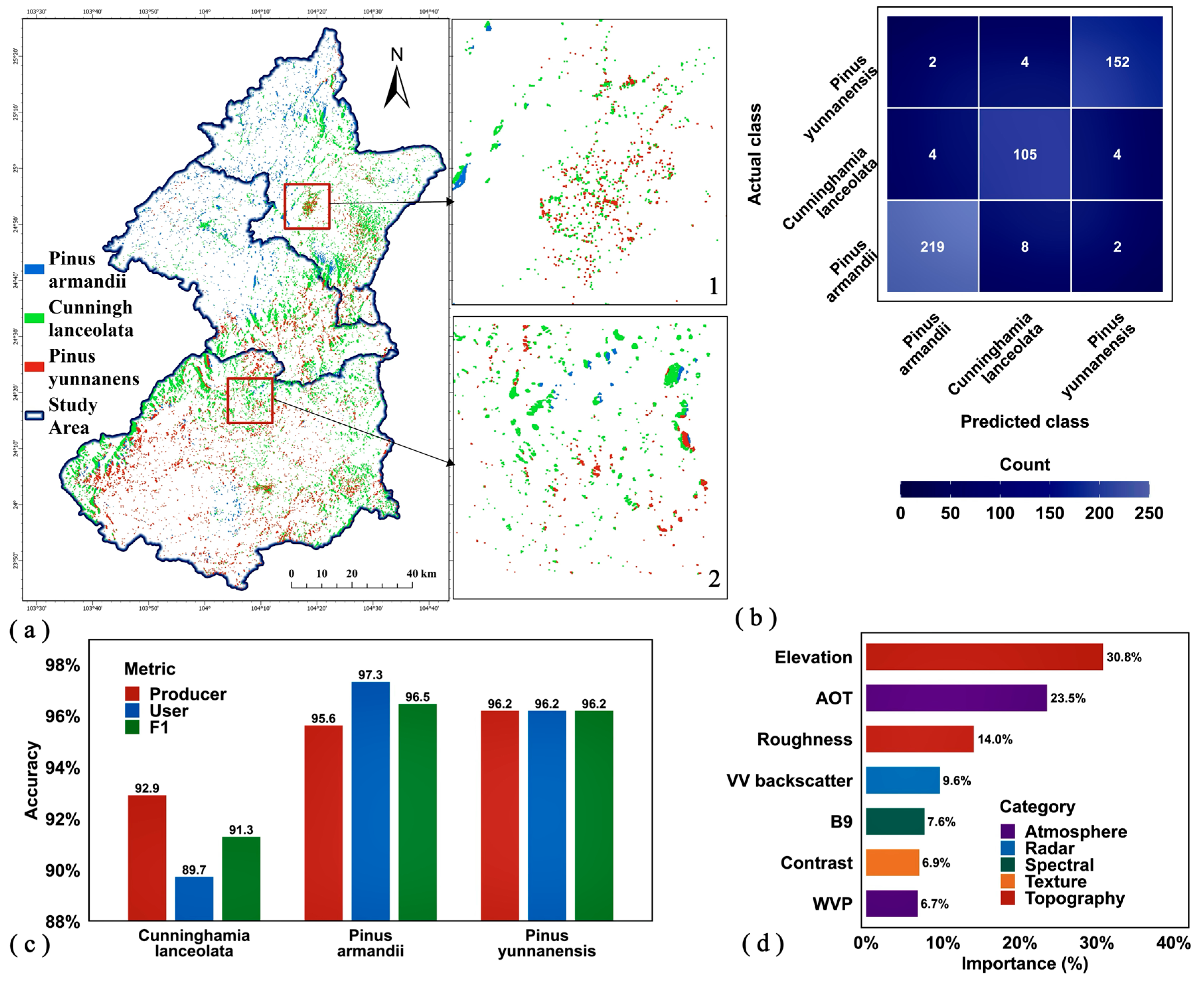
3.1. Tree Species Classification Results for Plantations
3.1.1. Classification Accuracy Validation
3.1.2. Feature Importance Analysis
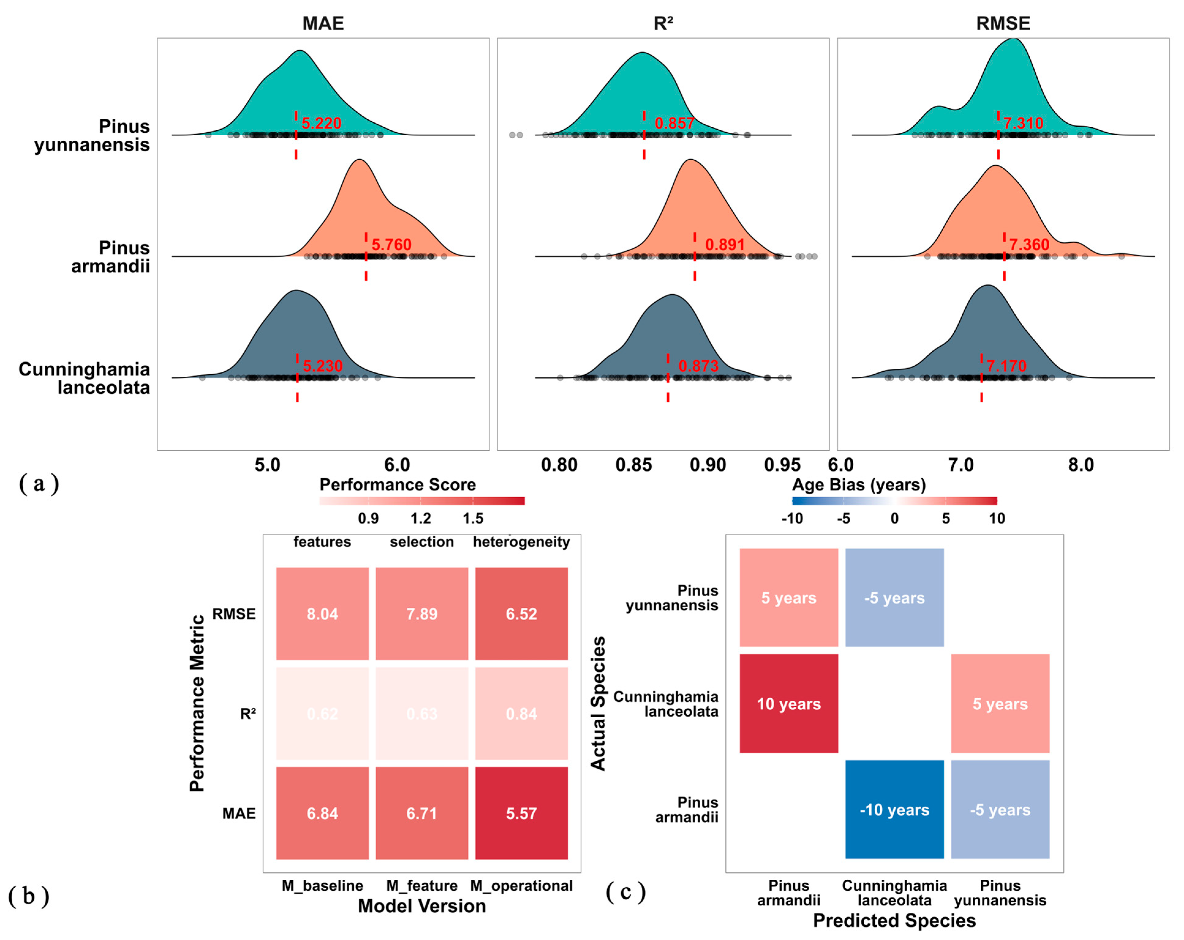
3.2. Plantation Age Estimation Results
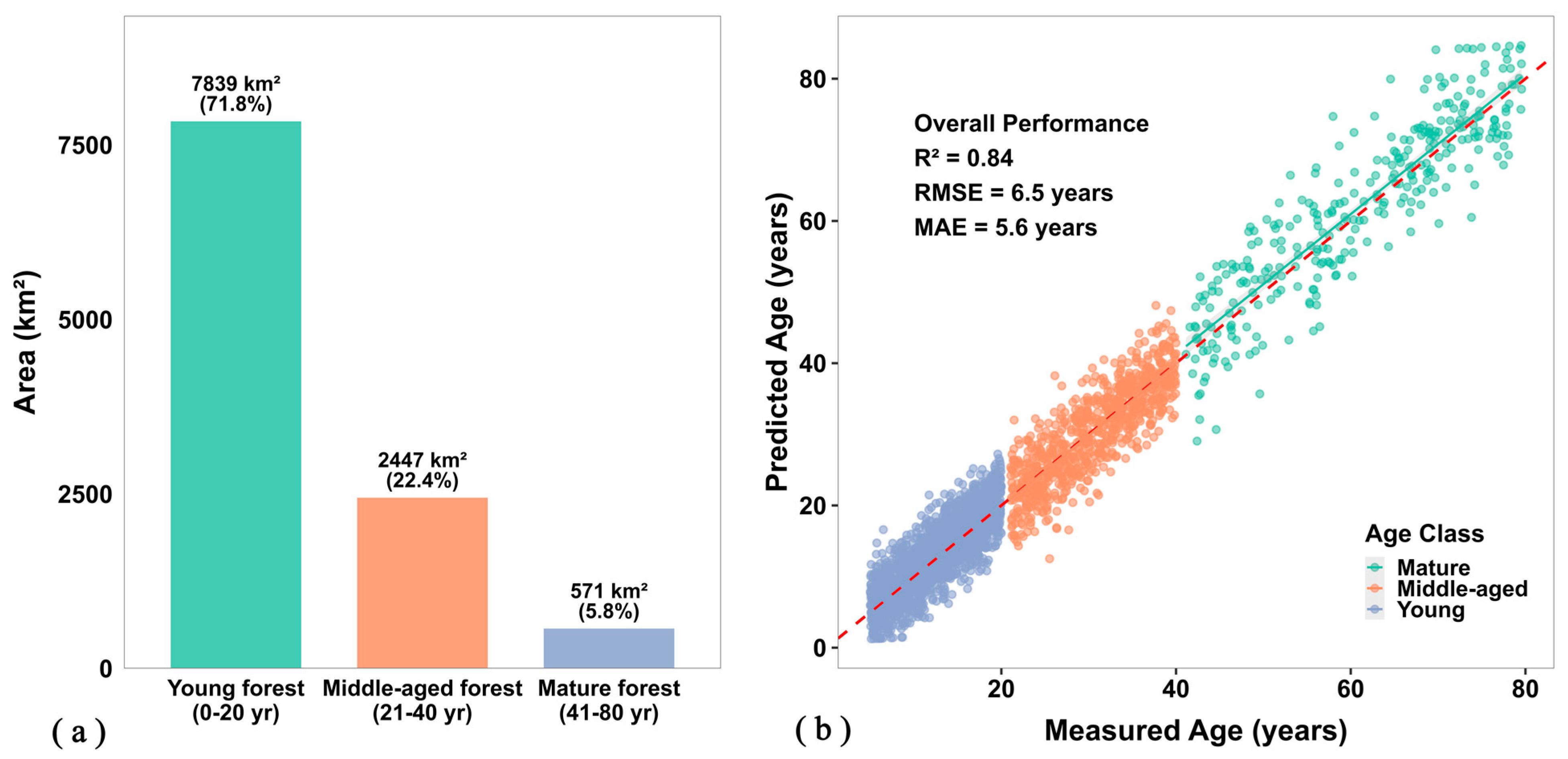
3.2.1. Model Accuracy Evaluation
3.2.2. Feature Contribution Analysis

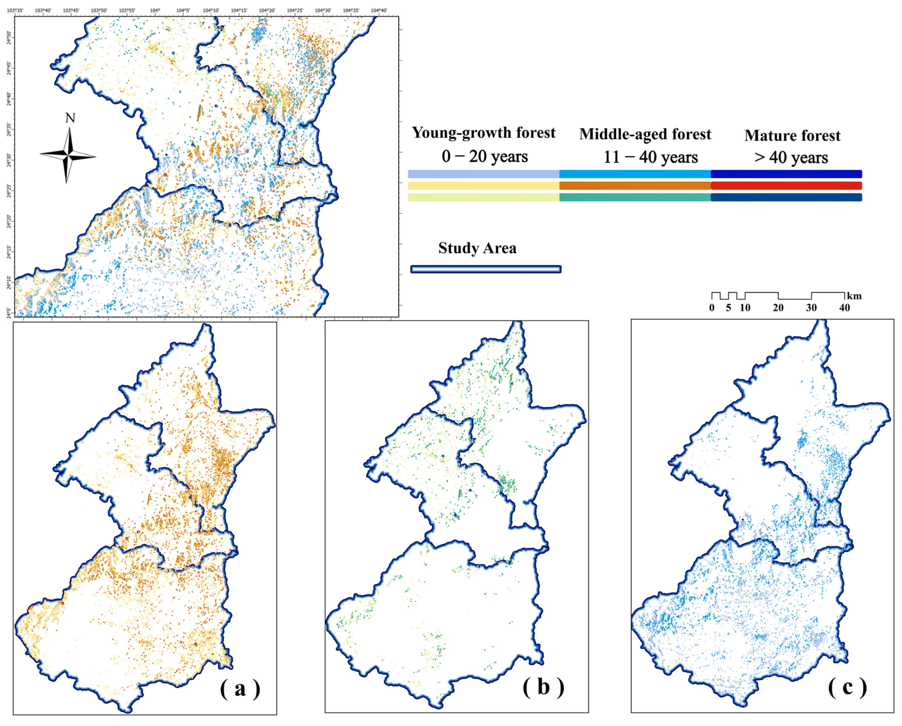
3.2.3. Spatial Patterns of Plantation Age
3.3. Uncertainty Analysis
4. Discussion
4.1. Methodological Contributions and Theoretical Implications
4.2. Methodological Contributions and Framework Robustness
4.3. Implications Within the Karst Ecosystem
4.4. Uncertainty Analysis and Robustness of Conclusions
4.5. Limitations and Future Perspectives
- (1)
- Species scope and regional specificity: The framework is optimized for three dominant conifers in the study region. Application to more diverse forests or other regions would require expanding the classification system and recalibrating species-specific parameters, which may introduce new error sources.
- (2)
- Indirect acquisition of ground-truth age: As noted in Section 4.4, future efforts should prioritize building more robust age validation datasets, potentially through integration of multi-temporal LiDAR (e.g., GEDI, ICESat-2) for direct height-growth chronologies or through dedicated permanent plot networks combined with dendrochronology [57].
- (3)
- Transferability of feature engineering: The inclusion of atmospheric variables (AOT, WVP) in classification, while marginally beneficial (~2.1% accuracy gain), raises concerns about interpretability and temporal generalizability due to potential dependency on acquisition conditions. Future work should investigate more physiographically stable features or spatiotemporal fusion techniques to enhance model portability [58].
- (4)
- Scope of innovation in classification: The species classification accuracy (OA = 89.34%) is consistent with prior regional work. The principal innovation lies not in this metric per se, but in the novel and systematic integration of the classifier’s probability output as a key driver for downstream heterogeneous growth modeling, coupled with the rigorous quantification of the entire workflow’s robustness.
5. Conclusions
- (1)
- Significant accuracy improvement: The operational model (M_operational) achieved an R2 of 0.84 (RMSE = 6.52 years), representing a substantial improvement over the baseline model that ignored species heterogeneity (R2 = 0.62).
- (2)
- Robust operational potential: Close agreement between overall accuracy and ideal “known species” conditions, combined with low sensitivity to classification errors (γ = 0.23), confirms practical robustness.
- (3)
- Ecological mechanism validation: Species functional trait differences drive heterogeneity in age–remote sensing relationships, confirming Plant Economic Spectrum theory’s applicability to regional-scale remote sensing inversion.
Author Contributions
Funding
Data Availability Statement
Acknowledgments
Conflicts of Interest
References
- Chen, Y.; Zhang, B.; Zhang, Y.; Wu, J. Carbon sequestration in forest plantation ecosystems. Front. For. Glob. Change 2024, 6, 1343488. [Google Scholar]
- Li, X.; Bi, C.; Wu, J.; Zhang, C.; Yan, W.; Xiao, Z.; Wang, Y.-P.; Ren, J.; Su, Y. Maximum carbon uptake potential through progressive management of plantation forests in Guangdong Province, China. Commun. Earth Environ. 2025, 6, 9. [Google Scholar] [CrossRef]
- Li, B.; Gao, G.; Luo, Y.; Xu, M.; Liu, G.; Fu, B. Carbon stock and sequestration of planted and natural forests along climate gradient in water-limited area: A synthesis in the China’s Loess plateau. Agric. For. Meteorol. 2023, 333, 109419. [Google Scholar] [CrossRef]
- Friedlingstein, P.; O’Sullivan, M.; Jones, M.W.; Andrew, R.M.; Bakker, D.C.E.; Hauck, J.; Landschützer, P.; Le Quéré, C.; Luijkx, I.T.; Peters, G.P.; et al. Global Carbon Budget 2023. Earth Syst. Sci. Data 2023, 15, 5301–5369. [Google Scholar] [CrossRef]
- Pugh, T.A.M.; Lindeskog, M.; Smith, B.; Poulter, B.; Arneth, A.; Haverd, V.; Calle, L. Role of forest regrowth in global carbon sink dynamics. Proc. Natl. Acad. Sci. USA 2019, 116, 4382–4387. [Google Scholar] [PubMed]
- Reich, P.B. The world-wide “fast–slow” plant economics spectrum: A traits manifesto. J. Ecol. 2014, 102, 275–301. [Google Scholar] [CrossRef]
- Wright, I.J.; Reich, P.B.; Westoby, M.; Ackerly, D.D.; Baruch, Z.; Bongers, F.; Cavender-Bares, J.; Chapin, T.; Cornelissen, J.H.C.; Diemer, M.; et al. The worldwide leaf economics spectrum. Nature 2004, 428, 821–827. [Google Scholar] [CrossRef]
- Nasiri, V.; Hawryło, P.; Tompalski, P.; Wertz, B.; Socha, J. Linking remotely sensed growth-related canopy attributes to interannual tree-ring width variations: A species-specific study using Sentinel optical and SAR time series. ISPRS J. Photogramm. Remote Sens. 2025, 221, 347–362. [Google Scholar] [CrossRef]
- Zhang, Y.; Lu, D.; Jiang, X.; Li, Y.; Li, D. Forest structure simulation of eucalyptus plantation using remote-sensing-based forest age data and 3-pg model. Remote Sens. 2022, 15, 183. [Google Scholar]
- Yu, Z.; You, W.; Agathokleous, E.; Zhou, G.; Liu, S. Forest management required for consistent carbon sink in China’s forest plantations. For. Ecosyst. 2021, 8, 54. [Google Scholar] [CrossRef]
- Farooq, T.H.; Shakoor, A.; Wu, X.; Li, Y.; Rashid, M.H.U.; Zhang, X.; Gilani, M.M.; Kumar, U.; Chen, X.; Yan, W. Perspectives of plantation forests in the sustainable forest development of China. Biogeosci. For. 2021, 14, 166–174. [Google Scholar] [CrossRef]
- Wang, X.; Shi, J.; Wang, C.; Gao, C.; Zhang, F. Remote sensing inversion and mapping of typical forest stand age in the loess plateau. Remote Sens. 2023, 15, 5581. [Google Scholar] [CrossRef]
- Tian, L.; Wu, X.; Tao, Y.; Li, M.; Qian, C.; Liao, L.; Fu, W. Review of remote sensing-based methods for forest aboveground biomass estimation: Progress, challenges, and prospects. Forests 2023, 14, 1086. [Google Scholar] [CrossRef]
- Yang, X.; Liu, Y.; Wu, Z.; Yu, Y.; Li, F.; Fan, W. Forest age mapping based on multiple-resource remote sensing data. Environ. Monit. Assess. 2020, 192, 734. [Google Scholar] [CrossRef] [PubMed]
- Donev, P.; Wang, H.; Qin, S.; Li, X.; Zhang, M.; Liu, S.; Wang, X. Cross-modal fusion approach with multispectral, LiDAR, and SAR data for forest canopy height mapping in mountainous region. Phys. Chem. Earth Parts A/B/C 2025, 137, 103819. [Google Scholar] [CrossRef]
- Li, J.; Hong, D.; Gao, L.; Yao, J.; Zheng, K.; Zhang, B.; Chanussot, J. Deep learning in multimodal remote sensing data fusion: A comprehensive review. Int. J. Appl. Earth Obs. Geoinf. 2022, 112, 102926. [Google Scholar] [CrossRef]
- Zeng, Y.; Hao, D.; Huete, A.; Dechant, B.; Berry, J.; Chen, J.M.; Joiner, J.; Frankenberg, C.; Bond-Lamberty, B.; Ryu, Y.; et al. Optical vegetation indices for monitoring terrestrial ecosystems globally. Nat. Rev. Earth Environ. 2022, 3, 477–493. [Google Scholar] [CrossRef]
- Radeloff, V.C.; Roy, D.P.; Wulder, M.A.; Anderson, M.; Cook, B.; Crawford, C.J.; Friedl, M.; Gao, F.; Gorelick, N.; Hansen, M.; et al. Need and vision for global medium-resolution Landsat and Sentinel-2 data products. Remote Sens. Environ. 2024, 300, 113918. [Google Scholar] [CrossRef]
- Hu, X.; Li, L.; Huang, J.; Zeng, Y.; Zhang, S.; Su, Y.; Hong, Y.; Hong, Z. Radar vegetation indices for monitoring surface vegetation: Developments, challenges, and trends. Sci. Total Environ. 2024, 945, 173974. [Google Scholar] [CrossRef]
- Chaurasia, A.N.; Parmar, R.M.; Dave, M.G.; Krishnayya, N.S.R. Integrating field-and remote sensing data to perceive species heterogeneity across a climate gradient. Sci. Rep. 2024, 14, 42. [Google Scholar] [CrossRef]
- Balestra, M.; Marselis, S.; Sankey, T.T.; Cabo, C.; Liang, X.; Mokroš, M.; Peng, X.; Singh, A.; Stereńczak, K.; Vega, C.; et al. LiDAR Data fusion to improve forest attribute estimates: A review. Curr. For. Rep. 2024, 10, 281–297. [Google Scholar] [CrossRef]
- Chen, J.; Liang, X.; Liu, Z.; Gong, W.; Chen, Y.; Hyyppä, J.; Kukko, A.; Wang, Y. Tree species recognition from close-range sensing: A review. Remote Sens. Environ. 2024, 313, 114337. [Google Scholar]
- Hemmerling, J.; Pflugmacher, D.; Hostert, P. Mapping temperate forest tree species using dense Sentinel-2 time series. Remote Sens. Environ. 2021, 267, 112743. [Google Scholar] [CrossRef]
- Ahlswede, S.; Schulz, C.; Gava, C.; Helber, P.; Bischke, B.; Förster, M.; Arias, F.; Hees, J.; Demir, B.; Kleinschmit, B. TreeSatAI Benchmark Archive: A multi-sensor, multi-label dataset for tree species classification in remote sensing. Earth Syst. Sci. Data 2022, 2022, 1–22. [Google Scholar]
- Persson, M.; Lindberg, E.; Reese, H. Tree species classification with multi-temporal Sentinel-2 data. Remote Sens. 2018, 10, 1794. [Google Scholar] [CrossRef]
- Qin, H.; Zhou, W.; Yao, Y.; Wang, W. Individual tree segmentation and tree species classification in subtropical broadleaf forests using UAV-based LiDAR, hyperspectral, and ultrahigh-resolution RGB data. Remote Sens. Environ. 2022, 280, 113143. [Google Scholar]
- Yan, K.; Gao, S.; Yan, G.; Ma, X.; Chen, X.; Zhu, P.; Li, J.; Gao, S.; Gastellu-Etchegorry, J.-P.; Myneni, R.B. A global systematic review of the remote sensing vegetation indices. Int. J. Appl. Earth Obs. Geoinf. 2025, 139, 104560. [Google Scholar]
- Liang, X.; Chen, J.; Gong, W.; Puttonen, E.; Wang, Y. Influence of data and methods on high-resolution imagery-based tree species recognition considering phenology: The case of temperate forests. Remote Sens. Environ. 2025, 323, 114654. [Google Scholar]
- Fassnacht, F.E.; White, J.C.; Wulder, M.A.; Næsset, E. Remote sensing in forestry: Current challenges, considerations and directions. Forestry 2024, 97, 11–37. [Google Scholar]
- Lin, X.; Shang, R.; Chen, J.M.; Zhao, G.; Zhang, X.; Huang, Y.; Yu, G.; He, N.; Xu, L.; Jiao, W. High-resolution forest age mapping based on forest height maps derived from GEDI and ICESat-2 space-borne lidar data. Agric. For. Meteorol. 2023, 339, 109592. [Google Scholar]
- Zhang, S.; Xu, H.; Liu, A.; Qi, S.; Hu, B.; Huang, M.; Luo, J. Mapping of secondary forest age in China using stacked generalization and Landsat time series. Sci. Data 2024, 11, 302. [Google Scholar] [CrossRef] [PubMed]
- Kennedy, R.E.; Yang, Z.; Cohen, W.B. Detecting trends in forest disturbance and recovery using yearly Landsat time series: 1. LandTrendr—Temporal segmentation algorithms. Remote Sens. Environ. 2010, 114, 2897–2910. [Google Scholar]
- Shen, W.J.; Li, M.S. Mapping disturbance and recovery of plantation forests in southern China using yearly Landsat time series observations. Acta Ecol. Sin. 2017, 37, 1438–1449. [Google Scholar] [CrossRef]
- Smolina, A.; Illarionova, S.; Shadrin, D.; Kedrov, A.; Burnaev, E. Forest age estimation in northern Arkhangelsk region based on machine learning pipeline on Sentinel-2 and auxiliary data. Sci. Rep. 2023, 13, 22167. [Google Scholar] [CrossRef]
- Jiang, Y.; Chen, Z.; Lin, H.; Deng, R.; Liang, Z.; Li, Y.; Liang, S. Trait-based community assembly and functional strategies across three subtropical karst forests, Southwestern China. Front. Plant Sci. 2024, 15, 1451981. [Google Scholar] [CrossRef]
- Qin, J.Z.; Dai, J.P.; Li, S.H.; Zhang, J.Z.; Peng, J.S. Construction of ecological network in Qujing city based on MSPA and MCR models. Sci. Rep. 2024, 14, 9800. [Google Scholar] [CrossRef] [PubMed]
- Takeda, S.; Takahashi, K. Elevational variation in abundance of coarse woody debris in subalpine forests, central Japan. For. Ecol. Manag. 2020, 473, 118295. [Google Scholar] [CrossRef]
- Kursa, M.B.; Rudnicki, W.R. Feature selection with the Boruta package. J. Stat. Softw. 2010, 36, 1–13. [Google Scholar]
- Zhang, X.; Zhang, C.; Fu, L. Mechanisms of Spatial Coupling Between Plantation Species Distribution and Historical Disturbance in the Complex Topography of Eastern Yunnan. Remote Sens. 2025, 17, 2925. [Google Scholar]
- Cheng, Z.; Aakala, T.; Larjavaara, M. Elevation, aspect, and slope influence woody vegetation structure and composition but not species richness in a human-influenced landscape in northwestern Yunnan, China. Front. For. Glob. Change 2023, 6, 1187724. [Google Scholar]
- Yang, B.; Zhao, Y.; Li, J.; Liu, M.; Feng, L.; Zhou, B.; Wu, L. Large-scale mapping and uncertainty assessment of dominant tree species in southern China based on Sentinel-2 time series. J. Environ. Manag. 2025, 390, 126293. [Google Scholar] [CrossRef] [PubMed]
- Lin, H.; Liu, X.; Han, Z.; Cui, H.; Dian, Y. Identification of tree species in forest communities at different altitudes based on Multi-Source Aerial Remote sensing data. Appl. Sci. 2023, 13, 4911. [Google Scholar] [CrossRef]
- Congalton, R.G. A review of assessing the accuracy of classifications of remotely sensed data. Remote Sens. Environ. 1991, 37, 35–46. [Google Scholar]
- Olofsson, P.; Foody, G.M.; Herold, M.; Stehman, S.V.; Woodcock, C.E.; Wulder, M.A. Good practices for estimating area and assessing accuracy of land change. Remote Sens. Environ. 2014, 148, 42–57. [Google Scholar] [CrossRef]
- Strobl, C.; Boulesteix, A.L.; Zeileis, A.; Hothorn, T. Bias in random forest variable importance measures: Illustrations, sources and a solution. BMC Bioinf. 2007, 8, 25. [Google Scholar]
- Díaz, S.; Kattge, J.; Cornelissen, J.H.C.; Wright, I.J.; Lavorel, S.; Dray, S.; Reu, B.; Kleyer, M.; Wirth, C.; Prentice, I.C.; et al. The global spectrum of plant form and function. Nature 2016, 529, 167–171. [Google Scholar] [CrossRef]
- Besnard, S.; Koirala, S.; Santoro, M.; Weber, U.; Nelson, J.; Gütter, J.; Herault, B.; Kassi, J.; N’Guessan, A.; Neigh, C.; et al. Mapping global forest age from forest inventories, biomass and climate data. Earth Syst. Sci. Data 2021, 2021, 1–22. [Google Scholar] [CrossRef]
- Messier, J.; McGill, B.J.; Lechowicz, M.J. How do traits vary across ecological scales? A case for trait-based ecology. Ecol. Lett. 2010, 13, 838–848. [Google Scholar]
- Stephens, D.; Diesing, M. A comparison of supervised classification methods for the prediction of substrate type using multibeam acoustic and legacy grain-size data. PLoS ONE 2014, 9, e93950. [Google Scholar]
- Maxwell, A.E.; Warner, T.A.; Fang, F. Implementation of machine-learning classification in remote sensing: An applied review. Int. J. Remote Sens. 2018, 39, 2784–2817. [Google Scholar]
- Gómez, C.; White, J.C.; Wulder, M.A. Optical remotely sensed time series data for land cover classification: A review. ISPRS J. Photogramm. Remote Sens. 2016, 116, 55–72. [Google Scholar] [CrossRef]
- Yang, Q.; Zhang, F.; Jiang, Z.; Li, W.; Zhang, J.; Zeng, F.; Li, H. Relationship between soil depth and terrain attributes in karst region in Southwest China. J. Soils Sediments 2014, 14, 1568–1576. [Google Scholar] [CrossRef]
- Pan, Y.; Birdsey, R.A.; Fang, J.; Houghton, R.; Kauppi, P.E.; Kurz, W.A.; Phillips, O.L.; Shvidenko, A.; Lewis, S.L.; Canadell, J.G.; et al. A large and persistent carbon sink in the world’s forests. Science 2011, 333, 988–993. [Google Scholar] [CrossRef]
- Foody, G.M. Status of land cover classification accuracy assessment. Remote Sens. Environ. 2002, 80, 185–201. [Google Scholar] [CrossRef]
- Zhao, K.; Suarez, J.C.; Garcia, M.; Hu, T.; Wang, C.; Londo, A. Utility of multitemporal lidar for forest and carbon monitoring: Tree growth, biomass dynamics, and carbon flux. Remote Sens. Environ. 2018, 204, 883–897. [Google Scholar]
- Ogle, K.; Barber, J.J.; Barron-Gafford, G.A.; Bentley, L.P.; Young, J.M.; Huxman, T.E.; Loik, M.E.; Tissue, D.T. Quantifying ecological memory in plant and ecosystem processes. Ecol. Lett. 2015, 18, 221–235. [Google Scholar] [PubMed]
- Chen, B.; Xiao, X.; Wu, Z.; Yun, T.; Kou, W.; Ye, H.; Lin, Q.; Doughty, R.; Dong, J.; Ma, J.; et al. Identifying establishment year and pre-conversion land cover of rubber plantations on Hainan Island, China using landsat data during 1987–2015. Remote Sens. 2018, 10, 1240. [Google Scholar] [CrossRef]
- Tuia, D.; Persello, C.; Bruzzone, L. Domain adaptation for the classification of remote sensing data: An overview of recent advances. IEEE Geosci. Remote Sens. Mag. 2016, 4, 41–57. [Google Scholar]
- Kattge, J.; Bönisch, G.; Díaz, S.; Lavorel, S.; Prentice, I.C.; Leadley, P.; Tautenhahn, S.; Werner, G.D.A.; Aakala, T.; Abedi, M.; et al. TRY plant trait database–enhanced coverage and open access. Glob. Change Biol. 2020, 26, 119–188. [Google Scholar]
- Friend, A.D.; Lucht, W.; Rademacher, T.T.; Keribin, R.; Betts, R.; Cadule, P.; Ciais, P.; Clark, D.B.; Dankers, R.; Falloon, P.D.; et al. Carbon residence time dominates uncertainty in terrestrial vegetation responses to future climate and atmospheric CO2. Proc. Natl. Acad. Sci. USA 2014, 111, 3280–3285. [Google Scholar]



| Data Category | Data/Feature | Specification | Purpose |
|---|---|---|---|
| Remote Sensing | Sentinel-2 MSI | 2024 growing season composite; Spatial res.: 10 m (B2, B3, B4, B8), 20 m (B5–B7, B8A, B11, B12), 60 m (B1, B9, B10); Temporal res.: 5-day revisit. | Calculation of vegetation indices. |
| Sentinel-1 SAR | 2024; Spatial res.: 10 m (IW GRD); Temporal res.: 12-day revisit. Polarizations: VV, VH. | Canopy structure information (RVI-derived). | |
| Landsat series | 1992–2024; Spatial res.: 30 m; Temporal res.: 16-day revisit. Processed with LandTrendr algorithm. | Disturbance history detection (Year of Detection, recovery rate). | |
| Environmental | SRTM DEM | Spatial res.: 30 m (1 arc-second). | Extraction of topographic features (elevation, slope, aspect, TPI). |
| Forest inventory | Temporal: 2015 survey, updated to 2024; Spatial unit: Subcompartment polygons. | Model training and validation (species & forest age labels). | |
| Feature Sets | Vegetation Indices | NDVI, EVI, NDMI, NBR, SAVI (derived from Sentinel-2). | Characterizing biophysical parameters. |
| Radar Features | VV, VH backscatter coefficients, and Radar Vegetation Index (RVI). | Providing structural information. | |
| Topographic | Elevation, slope, aspect, Topographic Position Index (TPI) (derived from SRTM). | Representing environmental gradients. | |
| Temporal | LandTrendr-derived Year of Disturbance (YOD) and spectral recovery rate. | Serving as baseline for age estimation. |
| Dataset | Total Samples | Samples (n) | Proportion (%) | Validation |
|---|---|---|---|---|
| Total Samples | Valid sample | 142,434 | 100 | - |
| Training set | 99,704 | 70 | - | |
| Test set | 42,730 | 30 | Spatial CV | |
| Species Composition | Chinese fir | 82,612 | 58 | R2 = 0.873 |
| Armand pine | 32,760 | 23 | R2 = 0.891 | |
| Yunnan pine | 27,062 | 19 | R2 = 0.857 | |
| Model Performance | M_baseline | - | - | R2 = 0.62, RMSE = 8.04 |
| M_operational | - | - | R2 = 0.84, RMSE = 6.52 |
| Species | Base Seedling Age (yr) | Elevation Adjustment | Recovery Sensitivity | Growth Rate Factor | Ecological Rationale |
|---|---|---|---|---|---|
| Pinus armandii | 8 | +2 yr (>1500 m) | 0.12 | 1.00 | Slow-growing, high-elevation adapted |
| Cunninghamia lanceolata | 4 | +1 yr (>1500 m) | 0.15 | 1.08 | Fast-growing, plantation management |
| Pinus yunnanensis | 6 | +2 yr (>1500 m) | 0.10 | 1.05 | Moderate growth, drought-tolerant |
Disclaimer/Publisher’s Note: The statements, opinions and data contained in all publications are solely those of the individual author(s) and contributor(s) and not of MDPI and/or the editor(s). MDPI and/or the editor(s) disclaim responsibility for any injury to people or property resulting from any ideas, methods, instructions or products referred to in the content. |
© 2026 by the authors. Licensee MDPI, Basel, Switzerland. This article is an open access article distributed under the terms and conditions of the Creative Commons Attribution (CC BY) license.
Share and Cite
Zhang, X.; Zhang, C.; Zhou, L.; Liu, H.; Fu, L.; Yang, W. Forest Age Estimation by Integrating Tree Species Identity and Multi-Source Remote Sensing: Validating Heterogeneous Growth Patterns Through the Plant Economic Spectrum Theory. Remote Sens. 2026, 18, 407. https://doi.org/10.3390/rs18030407
Zhang X, Zhang C, Zhou L, Liu H, Fu L, Yang W. Forest Age Estimation by Integrating Tree Species Identity and Multi-Source Remote Sensing: Validating Heterogeneous Growth Patterns Through the Plant Economic Spectrum Theory. Remote Sensing. 2026; 18(3):407. https://doi.org/10.3390/rs18030407
Chicago/Turabian StyleZhang, Xiyu, Chao Zhang, Li Zhou, Huan Liu, Lianjin Fu, and Wenlong Yang. 2026. "Forest Age Estimation by Integrating Tree Species Identity and Multi-Source Remote Sensing: Validating Heterogeneous Growth Patterns Through the Plant Economic Spectrum Theory" Remote Sensing 18, no. 3: 407. https://doi.org/10.3390/rs18030407
APA StyleZhang, X., Zhang, C., Zhou, L., Liu, H., Fu, L., & Yang, W. (2026). Forest Age Estimation by Integrating Tree Species Identity and Multi-Source Remote Sensing: Validating Heterogeneous Growth Patterns Through the Plant Economic Spectrum Theory. Remote Sensing, 18(3), 407. https://doi.org/10.3390/rs18030407