Detail Versus Certainty: A Metric Multi-Source Reconstruction of the Temple of Bel, Palmyra

 , ,
, ,  , , and
Highlights
- A reproducible framework for integrating heterogeneous historical datasets into a metrically anchored heritage model, transferable to any site documented by archival sources of unequal geometric quality.
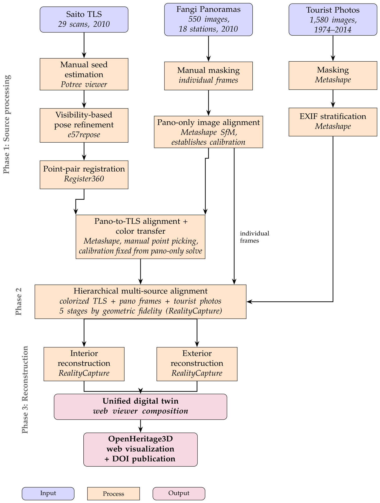
- A hierarchical alignment method that preserves metric accuracy across heterogeneous sources (TLS, panoramas, crowdsourced photos) by registering them in order of decreasing geometric fidelity.
- A visibility-based pose-recovery method for legacy TLS scans, released as open-source software.
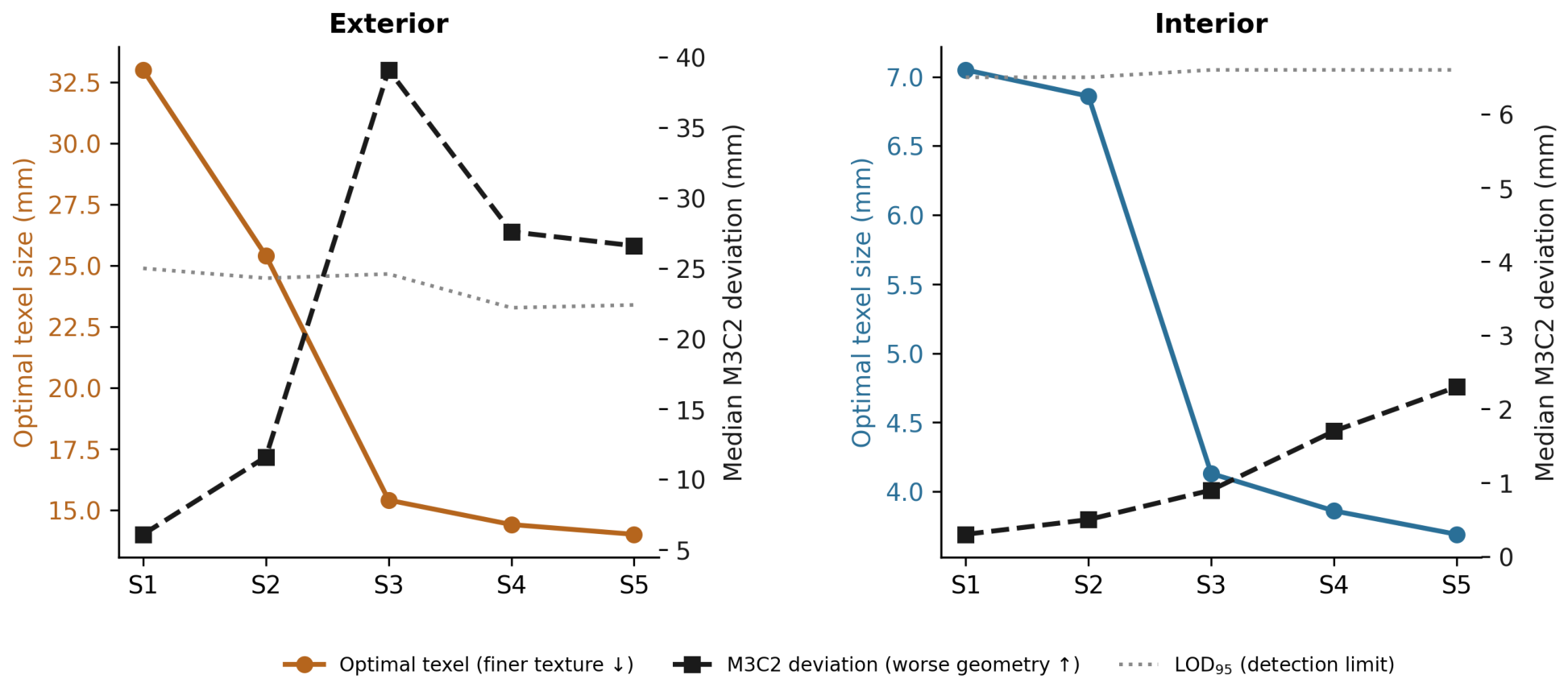
- Texture detail and geometric certainty diverge across fusion stages, so no single reconstruction serves all uses: laser-and-panorama stages for metric and conservation work, crowdsourced-photo stages for visualization
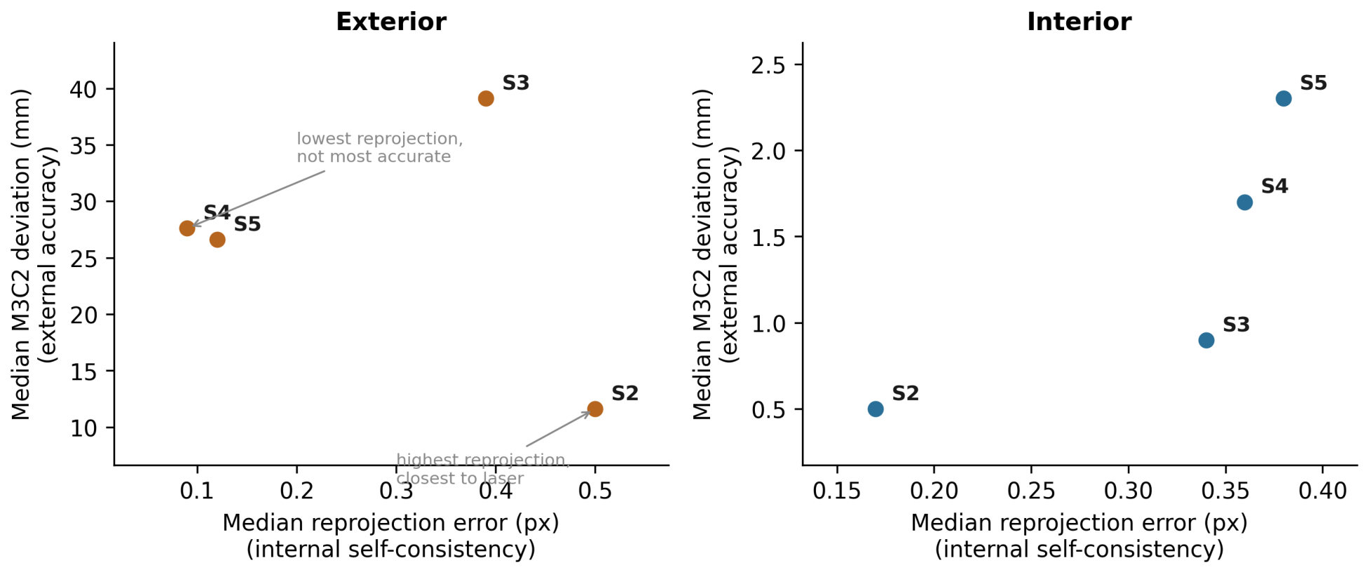
- Against a laser reference, internal photogrammetric metrics (reprojection error) do not predict geometric accuracy, exposing a resolution-versus-accuracy trade-off.
Abstract
1. Introduction
1.1. The 2015 Destruction
1.2. Current Situation
1.3. Digital Preservation Context
2. Literature Review
2.1. Foundations of Crowdsourced Photogrammetric Reconstruction
2.2. Previous Digital Reconstruction Efforts at Palmyra
2.3. Crowdsourced Data Platforms
2.4. Multi-Source Integration and Depth Map Fusion
3. Materials and Methods
3.1. Reconstruction Workflow Overview
3.2. Dataset Descriptions
3.2.1. Panoramic Photogrammetry
3.2.2. Terrestrial Laser Scanning
3.2.3. Tourist Photographs

| Cohort (Stage) | Images | Intrinsics in EXIF | Profile Available | Reg. at Stage (ext.) | Reg. at Stage (int.) |
|---|---|---|---|---|---|
| Known profile () | 1203 | Complete | Yes | 136 | 180 |
| Uncalibrated () | 357 | Complete | No | 53 | 94 |
| Metadata-deficient () | 20 | Absent | No | 18 | 24 |
| Total | 1,580 | — | — | 207 | 298 |
| Stage | Reg. Images | Tie Points | Median Reproj. (px) | Mean Reproj. (px) | Vertices |
|---|---|---|---|---|---|
| Exterior | |||||
| Colorized TLS | 71 | 44,003 | — | — | 1,651,636 |
| +Panoramas | 85 | 42,699 | 0.50 | 0.62 | 1,965,947 |
| +Photos (known) | 221 | 139,298 | 0.39 | 0.52 | 6,784,503 |
| +Photos (uncalib.) | 274 | 269,820 | 0.09 | 0.31 | 8,792,120 |
| +Photos (no EXIF) | 292 | 287,917 | 0.12 | 0.33 | 9,299,800 |
| Interior | |||||
| Colorized TLS | 12 | 67,998 | — | — | 9,109,288 |
| +Panoramas | 47 | 143,659 | 0.17 | 0.26 | 10,470,551 |
| +Photos (known) | 227 | 409,887 | 0.34 | 0.48 | 32,434,207 |
| +Photos (uncalib.) | 321 | 556,764 | 0.36 | 0.49 | 40,830,867 |
| +Photos (no EXIF) | 345 | 598,049 | 0.38 | 0.51 | 43,046,895 |
3.3. TLS Scan Pose Recovery and Registration
3.3.1. Manual Seed Estimation
3.3.2. Visibility-Based Pose Refinement
3.3.3. Scan-to-Scan Registration
3.3.4. Panorama-to-TLS Alignment and Color Transfer
3.4. Hierarchical Multi-Source Alignment
3.4.1. Alignment Sequence
3.4.2. Advantages
3.5. Adaptive Reconstruction Strategy for Heterogeneous Depth Sources
3.5.1. Observed Behavior
3.5.2. Split Reconstruction Strategy
3.6. Component Outputs and Comparative Geometric Analysis
3.6.1. RealityCapture Reports and Exports
3.6.2. Cloud-to-Cloud Comparison Against the Reference TLS
4. Archival Infrastructure and Web-Based Visualization
4.1. Data Publication
4.2. Archival Formats
4.3. Interactive Viewer
5. Results
5.1. An Exemplary Composite Reconstruction
5.2. Internal Alignment Behavior
5.3. Geometric Fidelity Against the Reference TLS
5.4. Qualitative Observations: Interior
5.5. Qualitative Observations: Exterior
5.6. Detail Versus Certainty
6. Discussion
6.1. Recommended Stage by Application
6.2. Comparison with Prior Panorama-Based Reconstructions
6.3. Effectiveness of EXIF-Based Image Stratification
6.4. The Value of Accumulating and Aligning Imagery Beyond Immediate Reconstruction Needs
6.5. Visualizing Individual Images in Space
6.6. Future Work
7. Conclusions
Supplementary Materials
Author Contributions
Funding
Data Availability Statement
Acknowledgments
Conflicts of Interest
Abbreviations
| DOI | Digital Object Identifier |
| EXIF | Exchangeable Image File Format |
| GIS | Geographic Information System |
| ICP | Iterative Closest Point |
| LiDAR | Light Detection and Ranging |
| MISP | Multi-Image Spherical Photogrammetry |
| MVS | Multi-View Stereo |
| SfM | Structure from Motion |
| TGV | Total Generalized Variation |
| TLS | Terrestrial Laser Scanning |
| TV | Total Variation |
| UNESCO | United Nations Educational, Scientific and Cultural Organization |
Appendix A. Fangi Panoramic Dataset
Appendix B. Saito TLS Dataset
Appendix C. Tourist Photo Reconstruction
Appendix D. Code Repository
Appendix E. Full Fusion Project
Appendix F. Video Walkthrough
Appendix G. Metashape-Only Implementation of the Hierarchical Alignment
References
- Dieb, R.; Alsalloum, A.; Webb, N. Interactive 360° media for the dissemination of endangered world heritage sites: The ancient city of Palmyra in Syria. Built Herit. 2024, 8, 18. [Google Scholar] [CrossRef] [Scilit]
- Silver, M.; Fangi, G.; Denker, A. Reviving Palmyra in Multiple Dimensions: Images, Ruins and Cultural Memory; Whittles Publishing: Dunbeath, UK, 2018. [Google Scholar]
- Denker, A. 3D visualization and photo-realistic reconstruction of the Great Temple of Bel. Int. Arch. Photogramm. Remote Sens. Spat. Inf. Sci. 2017, XLII-2/W3, 225–229. [Google Scholar] [CrossRef] [Scilit]
- Wahbeh, W.; Nebiker, S.; Fangi, G. Combining public domain and professional panoramic imagery for the accurate and dense 3D reconstruction of the destroyed Bel Temple in Palmyra. ISPRS Ann. Photogramm. Remote Sens. Spat. Inf. Sci. 2016, III-5, 81–88. [Google Scholar] [CrossRef] [Scilit][Green Version]
- Abdulkarim, M.; Seigne, J. The future of the Temple of Bel in Palmyra after its destruction. Bull. Am. Sch. Orient. Res. 2024, 391, 93–106. [Google Scholar] [CrossRef] [Scilit] [PubMed]
- Palmyrene Voices Initiative. Report on the Current State of Palmyra’s Antiquities After Liberation; Heritage for Peace: Barcelona, Spain, 2025; Available online: https://palmyrenevoices.org/ (accessed on 25 June 2026).
- Bakare, L. Heritage Experts Call for International Task Force to Plan Palmyra Rebuild. The Art Newspaper, 4 November 2025. Available online: https://www.theartnewspaper.com/2025/11/04/heritage-experts-call-for-an-international-task-force-to-rebuild-palmyra (accessed on 4 June 2026).
- Palmyra Museum Damaged by Shelling to Be Rebuilt with International Funding. The National, 31 October 2025. Available online: https://www.thenationalnews.com/news/mena/2025/10/31/palmyra-museum-damaged-by-shelling-to-be-rebuilt-with-international-funding/ (accessed on 4 June 2026).
- UNESCO World Heritage Centre. State of Conservation: Site of Palmyra (Syrian Arab Republic). 2025. Available online: https://whc.unesco.org/en/soc/4659/ (accessed on 4 June 2026).
- UNESCO World Heritage Centre. Emergency Safeguarding of the Portico of the Temple of Bel in Palmyra. Available online: https://whc.unesco.org/en/activities/903/ (accessed on 4 June 2026).
- ICONEM; Directorate General of Antiquities and Museums of Syria. Temple of Bel: Syrian Heritage Revival. 2016. Available online: http://syrianheritagerevival.org/palmyra/ (accessed on 4 June 2026).
- Snavely, N.; Seitz, S.M.; Szeliski, R. Photo tourism: Exploring photo collections in 3D. ACM Trans. Graph. 2006, 25, 835–846. [Google Scholar] [CrossRef] [Scilit]
- Agarwal, S.; Furukawa, Y.; Snavely, N.; Simon, I.; Curless, B.; Seitz, S.M.; Szeliski, R. Building Rome in a day. Commun. ACM 2011, 54, 105–112. [Google Scholar] [CrossRef] [Scilit]
- Morelli, L.; Mazzacca, G.; Trybała, P.; Gaspari, F.; Ioli, F.; Ma, Z.; Remondino, F.; Challis, K.; Poad, A.; Turner, A.; et al. The legacy of Sycamore Gap: The potential of photogrammetric AI for reverse engineering lost heritage with crowdsourced data. Int. Arch. Photogramm. Remote Sens. Spat. Inf. Sci. 2024, XLVIII-2-2024, 281–288. [Google Scholar] [CrossRef] [Scilit]
- Fangi, G. The multi-image spherical panoramas as a tool for architectural survey. In Proceedings of the XXI International CIPA Symposium, Athens, Greece, 1–6 October 2007; ISPRS Archives: Vienna, Austria, 2007; Volume XXXVI-5/C53. [Google Scholar]
- Fangi, G. Further developments of the spherical photogrammetry for cultural heritage. In Proceedings of the XXII CIPA Symposium, Kyoto, Japan, 11–15 October 2009. [Google Scholar]
- Fangi, G. Multi-scale multi-resolution spherical photogrammetry with long focal lenses for architectural surveys. In Proceedings of the ISPRS Midterm Symposium, Newcastle, UK, 21–24 June 2010; ISPRS Archives: Vienna, Austria, 2010; Volume XXXVIII, Part 5, pp. 228–233. [Google Scholar]
- Fangi, G.; Pierdicca, R. Notre Dame du Haut by spherical photogrammetry integrated by point clouds generated by multi-view software. Int. J. Herit. Digit. Era 2012, 1, 461–479. [Google Scholar] [CrossRef] [Scilit]
- Fangi, G.; Nardinocchi, C. Photogrammetric processing of spherical panoramas. Photogramm. Rec. 2013, 28, 293–311. [Google Scholar] [CrossRef] [Scilit]
- Saito, K. Study on Reconstruction of Historical Monuments and Archaeological Sites Using 3D Images from Photographs (KAKENHI Grant 17K18520); Japan Society for the Promotion of Science: Tokyo, Japan, 2021; Available online: https://kaken.nii.ac.jp/en/grant/KAKENHI-PROJECT-17K18520/.
- NewPalmyra. #NEWPALMYRA: A Digital Archaeology Project. 2018. Available online: https://newpalmyra.org/ (accessed on 25 June 2026).
- McAvoy, S. Temple of Bel Tourist Photo Reconstruction; Open Heritage 3D: San Diego, CA, USA, 2020. [Google Scholar] [CrossRef]
- Wahbeh, W.; Nebiker, S. Three dimensional reconstruction workflows for lost cultural heritage monuments exploiting public domain and professional photogrammetric imagery. ISPRS Ann. Photogramm. Remote Sens. Spat. Inf. Sci. 2017, IV-2/W2, 319–325. [Google Scholar] [CrossRef] [Scilit]
- Tola, E.; Strecha, C.; Fua, P. Efficient large-scale multi-view stereo for ultra high-resolution image sets. Mach. Vis. Appl. 2012, 23, 903–920. [Google Scholar] [CrossRef] [Scilit]
- Antensteiner, D.; Štolc, S.; Pock, T. A review of depth and normal fusion algorithms. Sensors 2018, 18, 431. [Google Scholar] [CrossRef] [Scilit] [PubMed]
- Burgdorfer, N.; Mordohai, P. V-FUSE: Volumetric depth map fusion with long-range constraints. In Proceedings of the IEEE/CVF Conference on Computer Vision and Pattern Recognition, Vancouver, BC, Canada, 17–24 June 2023; pp. 13142–13151. [Google Scholar]
- Qin, R.; Ling, X.; Farella, E.M.; Remondino, F. Uncertainty-guided depth fusion from multi-view satellite images to improve the accuracy in large-scale DSM generation. Remote Sens. 2022, 14, 1309. [Google Scholar] [CrossRef] [Scilit]
- Maskeliūnas, R.; Maqsood, S.; Vaškevičius, M.; Gelšvartas, J. Fusing LiDAR and photogrammetry for accurate 3D data: A hybrid approach. Remote Sens. 2025, 17, 443. [Google Scholar] [CrossRef] [Scilit]
- Wang, C.; Gu, Y.; Li, X. LPRnet: A self-supervised registration network for LiDAR and photogrammetric point clouds. arXiv 2025, arXiv:2501.05669. [Google Scholar] [CrossRef] [Scilit]
- Alshawabkeh, Y. Integration of laser scanning and photogrammetry for heritage documentation. In Progress in Cultural Heritage Preservation; Ioannides, M., Fritsch, D., Leissner, J., Davies, R., Remondino, F., Caffo, R., Eds.; Lecture Notes in Computer Science; Springer: Berlin/Heidelberg, Germany, 2014; Volume 7616, pp. 424–431. [Google Scholar]
- Abdelhafiz, A. Integrating Digital Photogrammetry and Laser Scanning. Ph.D. Thesis, Deutsche Geodätische Kommission, Munich, Germany, 2009. [Google Scholar]
- Saito, K.; Sugiyama, T. (Eds.) Proceedings of the Conference “Saving the Syrian Cultural Heritage for the Next Generation: Palmyra, a Message from Nara”; Archaeological Institute of Kashihara, Nara Prefecture: Nara, Japan, 2018; pp. 88–89. [Google Scholar]
- Huber, D. The ASTM E57 file format for 3D imaging data exchange. In Proceedings of the SPIE 7864, Three-Dimensional Imaging, Interaction, and Measurement, San Francisco, CA, USA, 27 January 2011. [Google Scholar] [CrossRef] [Scilit]
- Pomerleau, F.; Colas, F.; Siegwart, R. A review of point cloud registration algorithms for mobile robotics. Found. Trends Robot. 2015, 4, 1–104. [Google Scholar] [CrossRef] [Scilit]
- Dong, Z.; Yang, B.; Liang, F.; Huang, R.; Scherer, S. Registration of laser scanning point clouds: A review. Sensors 2018, 18, 1641. [Google Scholar] [CrossRef] [Scilit] [PubMed]
- Theiler, P.W.; Wegner, J.D.; Schindler, K. Globally consistent registration of terrestrial laser scans via graph optimization. ISPRS J. Photogramm. Remote Sens. 2015, 109, 126–136. [Google Scholar] [CrossRef] [Scilit]
- Schütz, M. Potree: Rendering Large Point Clouds in Web Browsers. Master’s Thesis, Vienna University of Technology, Vienna, Austria, 2016. Available online: https://www.cg.tuwien.ac.at/research/publications/2016/SCHUETZ-2016-POT (accessed on 25 June 2026).
- Amanatides, J.; Woo, A. A fast voxel traversal algorithm for ray tracing. In Proceedings of Eurographics ’87; Marechal, G., Ed.; Eurographics Association: Amsterdam, The Netherlands, 1987; pp. 3–10. [Google Scholar]
- Shannon, C.E. A mathematical theory of communication. Bell Syst. Tech. J. 1948, 27, 379–423. [Google Scholar] [CrossRef] [Scilit]
- Nelder, J.A.; Mead, R. A simplex method for function minimization. Comput. J. 1965, 7, 308–313. [Google Scholar] [CrossRef] [Scilit]
- American Society for Photogrammetry and Remote Sensing. LAS Specification v.1.4-R15. 9 July 2019. Available online: https://www.asprs.org/divisions-committees/lidar-division/laser-las-file-format-exchange-activities (accessed on 25 June 2026).
- Kedzierski, M.; Fryskowska, A.; Wierzbicki, D.; Dabrowska, M.; Grochala, A. Impact of the method of registering Terrestrial Laser Scanning data on the quality of documenting cultural heritage structures. Int. Arch. Photogramm. Remote Sens. Spat. Inf. Sci. 2015, XL-5/W7, 245–248. [Google Scholar] [CrossRef] [Scilit]
- Agisoft LLC. Terrestrial Laser Scanning Data Processing. Agisoft Helpdesk Portal, 2024. Available online: https://agisoft.freshdesk.com/support/solutions/articles/31000159101 (accessed on 31 May 2026).
- Özyeşil, O.; Voroninski, V.; Basri, R.; Singer, A. A survey of structure from motion. Acta Numer. 2017, 26, 305–364. [Google Scholar] [CrossRef] [Scilit]
- Schönberger, J.L.; Frahm, J.-M. Structure-from-motion revisited. In Proceedings of the IEEE Conference on Computer Vision and Pattern Recognition, Las Vegas, NV, USA, 27–30 June 2016; pp. 4104–4113. [Google Scholar] [CrossRef] [Scilit]
- Moulon, P.; Monasse, P.; Marlet, R. Global fusion of relative motions for robust, accurate and scalable structure from motion. In Proceedings of the IEEE International Conference on Computer Vision, Sydney, Australia, 1–8 December 2013; pp. 3248–3255. [Google Scholar] [CrossRef] [Scilit]
- Zhu, S.; Zhang, R.; Zhou, L.; Shen, T.; Fang, T.; Tan, P.; Quan, L. Very large-scale global SfM by distributed motion averaging. In Proceedings of the IEEE Conference on Computer Vision and Pattern Recognition, Salt Lake City, UT, USA, 18–23 June 2018; pp. 4568–4577. [Google Scholar] [CrossRef] [Scilit]
- Dong, Z.; Yang, B.; Liang, F.; Huang, R.; Scherer, S. Hierarchical registration of unordered TLS point clouds based on binary shape context descriptor. ISPRS J. Photogramm. Remote Sens. 2018, 144, 61–79. [Google Scholar] [CrossRef] [Scilit]
- Ch’ng, E.; Cai, S.; Zhang, T.E.; Leow, F.T. Crowdsourcing 3D cultural heritage: Best practice for mass photogrammetry. J. Cult. Herit. Manag. Sustain. Dev. 2019, 9, 305–318. [Google Scholar] [CrossRef] [Scilit]
- Vincent, M.L.; Gutierrez, M.F.; Coughenour, C.; Manuel, V.; Bendicho, L.-M.; Remondino, F.; Fritsch, D. Crowd-sourcing the 3D digital reconstructions of lost cultural heritage. In Proceedings of the 2015 Digital Heritage, Granada, Spain, 28 September–2 October 2015; IEEE: New York, NY, USA, 2015; Volume 1, pp. 171–172. [Google Scholar] [CrossRef] [Scilit]
- Cornelis, K.; Verbiest, F.; Van Gool, L. Drift detection and removal for sequential structure from motion algorithms. IEEE Trans. Pattern Anal. Mach. Intell. 2004, 26, 1249–1259. [Google Scholar] [CrossRef] [PubMed]
- Lague, D.; Brodu, N.; Leroux, J. Accurate 3D comparison of complex topography with terrestrial laser scanner: Application to the Rangitikei canyon (N-Z). ISPRS J. Photogramm. Remote Sens. 2013, 82, 10–26. [Google Scholar] [CrossRef] [Scilit]
- py4dgeo Development Core Team. py4dgeo: Library for Change Analysis in 4D Point Clouds [Computer Software]. 2024. Available online: https://github.com/3dgeo-heidelberg/py4dgeo (accessed on 25 June 2026).
- UNESCO. Guidelines for the Preservation of Digital Heritage; UNESCO: Paris, France, 2003; Available online: https://unesdoc.unesco.org/ark:/48223/pf0000130071 (accessed on 25 June 2026).
- McAvoy, S.; Ristevski, J.; Rissolo, D.; Kuester, F. OpenHeritage3D: Building an open visual archive for site scale giga-resolution LiDAR and photogrammetry data. ISPRS Ann. Photogramm. Remote Sens. Spat. Inf. Sci. 2023, X-M-1-2023, 215–222. [Google Scholar] [CrossRef] [Scilit]
- DataCite. DataCite Metadata Schema 4.4. 2021. Available online: https://schema.datacite.org (accessed on 25 June 2026).
- Three.js Authors. Three.js, Version r126. 2020. Available online: https://github.com/mrdoob/three.js (accessed on 25 June 2026).
- Krishnan, S.; Crosby, C.J.; Nandigam, V.; Phan, M.; Cowart, C.; Baru, C.; Arrowsmith, R.J. OpenTopography: A services oriented architecture for community access to LIDAR topography. In Proceedings of the 2nd International Conference on Computing for Geospatial Research & Applications, Washington, DC, USA, 23–25 May 2011. [Google Scholar] [CrossRef] [Scilit]
- Cesium. CesiumJS. 2024. Available online: https://cesium.com/platform/cesiumjs/ (accessed on 25 June 2026).
- McAvoy, S.; Pérez Rivas, M.E.; Gallegos Flores, J.M.; Dorshow, W.; Stanton, T.; Cortés Arreola, C.; Rissolo, D.; Meacham, S.; Fortin, J.; Osorio León, J.F.J.; et al. Towards a Mexican National Archaeological Atlas: Scalable 3D Web GIS and archival systems for big data. Int. Arch. Photogramm. Remote Sens. Spat. Inf. Sci. 2025, XLVIII-M-9-2025, 1005–1011. [Google Scholar] [CrossRef] [Scilit]
- Agisoft LLC. Agisoft Metashape User Manual: Professional Edition, Version 2.2; Agisoft LLC: St. Petersburg, Russia, 2024; Available online: https://www.agisoft.com/pdf/metashape-pro_2_2_en.pdf (accessed on 31 May 2026).
- Alshawabkeh, Y.; Baik, A. Integration of photogrammetry and laser scanning for enhancing scan-to-HBIM modeling of Al Ula heritage site. Herit. Sci. 2023, 11, 147. [Google Scholar] [CrossRef] [Scilit]
- Oprea, R.-L.; Badea, A.C.; Badea, G. Multi-Source 3D Documentation for Preserving Cultural Heritage. Appl. Sci. 2026, 16, 1834. [Google Scholar] [CrossRef] [Scilit]



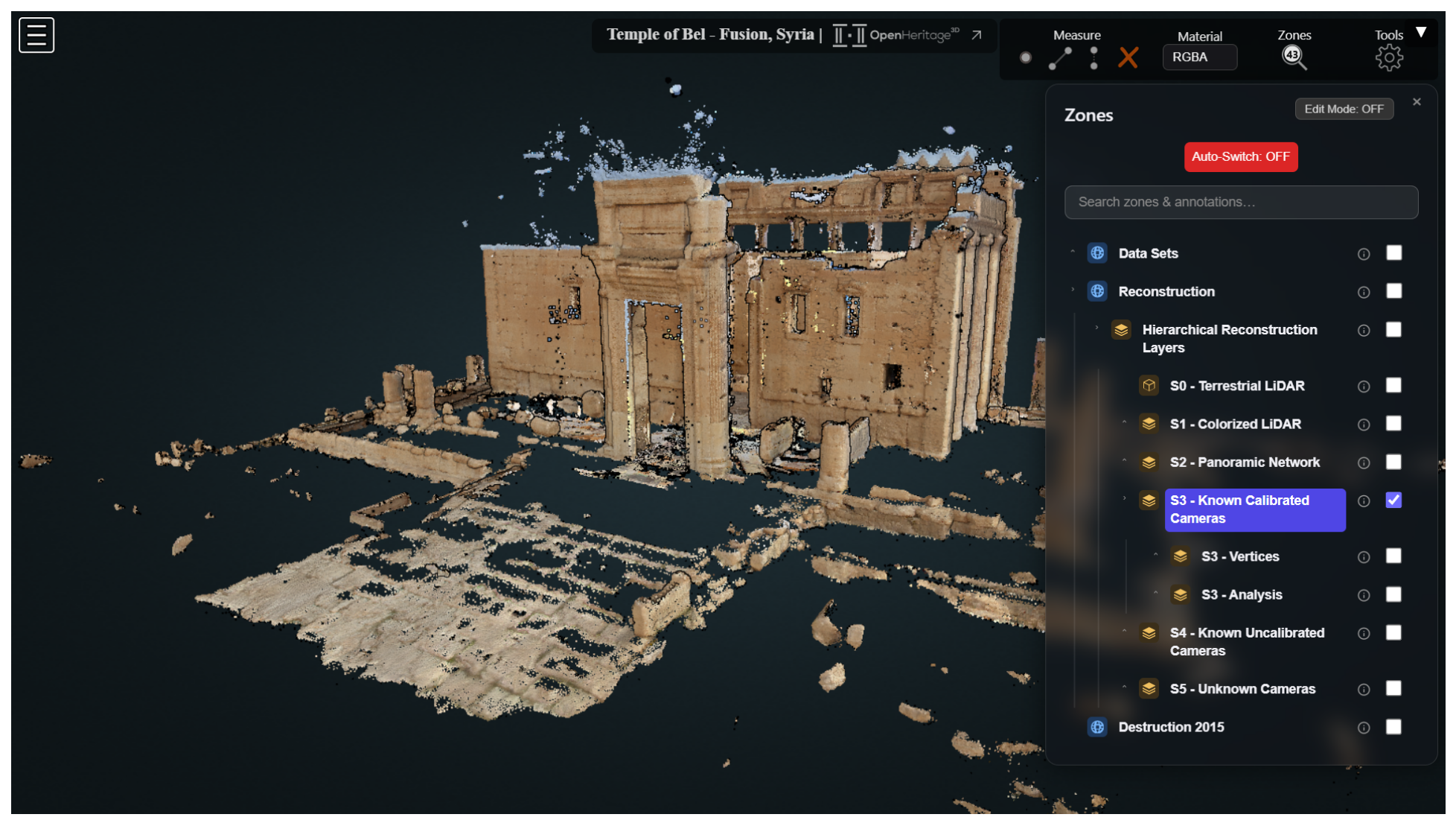


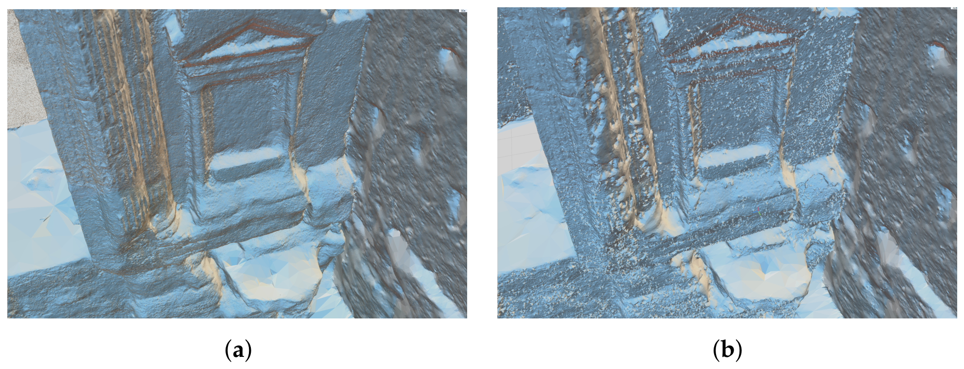
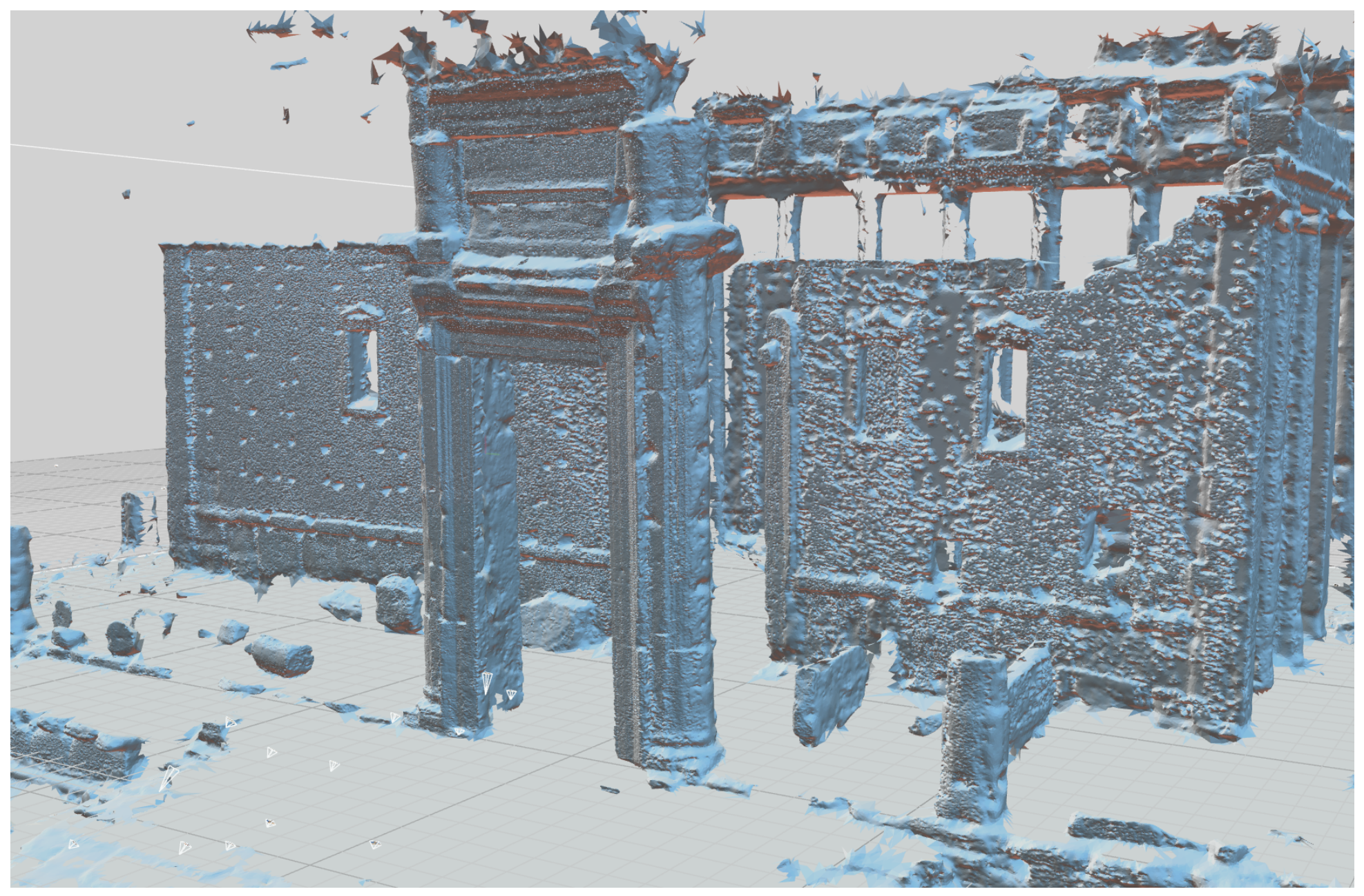

| Data Type | Author | Date | DOI |
|---|---|---|---|
| Terrestrial Laser Scanning | Dr. Kiyohide Saito | 2010 | 10.34946/D6CP4M |
| Panoramic Images | Dr. Gabriele Fangi | 2010 | 10.34946/D6HC7W |
| Tourist Photos | Various (#NewPalmyra) | 1974–2014 | 10.26301/zjnn-wx58 |
| Stage | Median |d| (mm) | ×Floor | p95 (mm) | LOD95 (mm) | Signif. (%) | Opt. Texel (mm) |
|---|---|---|---|---|---|---|
| Exterior (floor mm) | ||||||
| Colorized TLS | 6.1 | 1.0 | 198 | 25.0 | 11.4 | 33.0 |
| +Panoramas | 11.6 | 1.9 | 211 | 24.3 | 21.4 | 25.4 |
| +Photos (known) | 39.1 | 6.4 | 706 | 24.6 | 50.5 | 15.4 |
| +Photos (uncalib.) | 27.6 | 4.5 | 672 | 22.2 | 52.1 | 14.4 |
| +Photos (no EXIF) | 26.6 | 4.4 | 673 | 22.4 | 52.3 | 14.0 |
| Interior (floor mm) | ||||||
| Colorized TLS | 0.3 | 1.0 | 4.7 | 6.5 | 0.5 | 7.05 |
| +Panoramas | 0.5 | 1.7 | 12.7 | 6.5 | 7.4 | 6.86 |
| +Photos (known) | 0.9 | 3.0 | 27.5 | 6.6 | 18.9 | 4.13 |
| +Photos (uncalib.) | 1.7 | 5.7 | 73.4 | 6.6 | 19.3 | 3.86 |
| +Photos (no EXIF) | 2.3 | 7.7 | 62.0 | 6.6 | 25.6 | 3.69 |
| Application | Privileges | Recommended Stage |
|---|---|---|
| Conservation, restoration, metrology | Geometric certainty | /, |
| Geometry-based research (form, proportion, deformation) | Geometric certainty | / |
| Surface/iconographic research | Texture detail (geometry caveat) | Photo-augmented stages |
| Storytelling, dissemination, virtual reality | Visual richness |
Disclaimer/Publisher’s Note: The statements, opinions and data contained in all publications are solely those of the individual author(s) and contributor(s) and not of MDPI and/or the editor(s). MDPI and/or the editor(s) disclaim responsibility for any injury to people or property resulting from any ideas, methods, instructions or products referred to in the content. |
© 2026 by the authors. Licensee MDPI, Basel, Switzerland. This article is an open access article distributed under the terms and conditions of the Creative Commons Attribution (CC BY) license.
Share and Cite
McAvoy, S.; Wahbeh, W.; Menna, F.; Nocerino, E.; Agarwal, A.; Kuester, F. Detail Versus Certainty: A Metric Multi-Source Reconstruction of the Temple of Bel, Palmyra. Remote Sens. 2026, 18, 3038. https://doi.org/10.3390/rs18173038
McAvoy S, Wahbeh W, Menna F, Nocerino E, Agarwal A, Kuester F. Detail Versus Certainty: A Metric Multi-Source Reconstruction of the Temple of Bel, Palmyra. Remote Sensing. 2026; 18(17):3038. https://doi.org/10.3390/rs18173038
Chicago/Turabian StyleMcAvoy, Scott, Wissam Wahbeh, Fabio Menna, Erica Nocerino, Aviral Agarwal, and Falko Kuester. 2026. "Detail Versus Certainty: A Metric Multi-Source Reconstruction of the Temple of Bel, Palmyra" Remote Sensing 18, no. 17: 3038. https://doi.org/10.3390/rs18173038
APA StyleMcAvoy, S., Wahbeh, W., Menna, F., Nocerino, E., Agarwal, A., & Kuester, F. (2026). Detail Versus Certainty: A Metric Multi-Source Reconstruction of the Temple of Bel, Palmyra. Remote Sensing, 18(17), 3038. https://doi.org/10.3390/rs18173038