1. Introduction
The nearshore region, as the critical interface between the ocean and land, is of considerable importance for intelligent surveillance [
1], water search and rescue [
2], and navigation safety assurance [
3]. With the increasing in human activities in nearshore areas, the demand for automated and intelligent monitoring of nearshore objects has grown substantially [
4]. Owing to their advantages of low cost, high spatial resolution, and rich texture information [
5], visible imaging devices have been widely deployed in nearshore surveillance systems and have become a primary data source for nearshore object detection [
6]. Unlike satellite, UAV, or shipborne imagery, overhead surveillance imagery is captured by fixed visible cameras deployed along coastal areas, providing long-term observations of nearshore regions from an elevated perspective. By leveraging visible monitoring systems for real-time observation of nearshore scenes, objects such as human activities, approaching vessels, and floating debris on the sea surface can be promptly detected, thereby providing crucial support for nearshore security management and emergency response.
In nearshore scenarios, the scene typically consists of ocean, coast and beach regions arranged from far to near. These regions exhibit significant differences in visual characteristics and object distributions in visible images. For instance, in distant ocean areas, objects are usually small in scale and have low contrast; near the coast, waves and complex background textures tend to interfere with object detection; while in close beach areas, humans are often densely distributed and are affected by occlusions. Furthermore, in nearshore monitoring scenarios, visible image is highly susceptible to illumination variations. Factors such as nighttime environments, backlighting, and haze can substantially degrade image quality. These complex environmental factors make nearshore object detection a highly challenging task.
Recently, object detection methods have achieved remarkable performance in a wide variety of natural scene applications. However, most generic object detection models are primarily trained on visible data, and their design and optimization typically rely on generic datasets, such as MS COCO [
7]. These datasets mainly consist of urban street views and everyday scenarios, which differ significantly from nearshore environments in terms of data distribution and visual characteristics. Therefore, directly applying generic object detection models to nearshore object detection task often fails to achieve satisfactory detection performance.
Existing public datasets mainly emphasize vessel detection, while only a limited number of floating objects and swimmers are included, making them insufficient for comprehensive nearshore object detection. Few existing datasets are specifically designed for the simultaneous detection of the three core categories: humans, ships and floating objects. To address the above issues and promote the development of nearshore applications, this paper takes the following measures: first, a dataset annotated with humans, ships, and floating objects is constructed; then, the constructed dataset is used to evaluate a variety of deep learning-based detection methods.
We build a new large-scale visible nearshore object detection dataset. We collect a large number of visible images, and conduct screening, cropping, and categorization on these images, finally obtaining 20,934 images. We take humans, vessels, and floating objects as the main detection objects, and further divide them into seven detailed categories. The dataset also contains various challenging samples, such as small object instances and samples with densely occluded pedestrians.
With the evolution of algorithms in computer vision, object detection methods have progressively evolved from conventional handcrafted techniques to deep learning frameworks, resulting in remarkable leaps in both detection performance and speed. To validate the merit of the proposed dataset, we conducted performance evaluations on multiple lightweight detection methods, encompassing the YOLO series, RT-DETR series, D-FINE and DEIM. Based on the results obtained from these evaluations, we have substantiated that our dataset is both valuable and reasonable.
In conclusion, the main contributions of this study are summarized as follows:
- (1)
A large-scale visible nearshore dataset is constructed, comprising 20,934 annotated images and 58,482 instances carefully annotated using horizontal bounding boxes and seven fine-grained categories. Unlike existing datasets that solely emphasize vessels, this dataset offers a more comprehensive representation.
- (2)
Multiple mainstream object detection methods are comprehensively evaluated on the proposed dataset, establishing a benchmark for visible nearshore object detection task. The benchmark provides a platform for fair comparison and in-depth analysis of different detection methods, facilitating the development and deployment of visible nearshore object detection.
- (3)
A novel visible nearshore object detection framework termed VN-DETR is proposed for visible nearshore scenarios. Specifically, a kernel selective attention based on WTConv (WKSA) module is designed and integrated into the feature extraction backbone, while a cross-layer feature selection and fusion (CFSF) module is introduced to optimize the feature fusion pyramid. These designs enhance the ability to capture small object features in visible images, improving detection accuracy and reducing false detections caused by background noise.
The structure of this paper is summarized as follows.
Section 2 introduces some important work related to visible nearshore object detection task.
Section 3 presents the constructed visible nearshore dataset including data collection, annotation strategy, and statistical analysis.
Section 4 describes the proposed visible nearshore object detection model. The experimental results and analysis of the proposed model are reported in
Section 5.
Section 6 discusses the challenges and limitations of visible nearshore object detection. Finally, the conclusions and future research directions are provided in
Section 7.
2. Related Work
2.1. Visible Nearshore Datasets
In the field of nearshore object detection, among the currently published datasets as shown in
Table 1, there are specialized ones for ship detection, swimmer detection, and floating debris detection. Among them, the ship datasets are the most numerous, largest in scale, and richest in variety. The development of such datasets has enabled rapid progress in nearshore object detection. Due to their crucial applications in areas such as nearshore safety monitoring, ship classification, and maritime traffic surveillance, nearshore object detection has also garnered further attention.
As shown in
Table 1, compared with existing visible maritime object detection datasets, VND provides a larger-scale and more diverse benchmark specifically tailored for shoreline overhead surveillance, covering seven representative nearshore object categories and 20,934 images with substantial variations in image resolution, thereby better reflecting the complex visual characteristics and scale variations encountered in real-world nearshore environments.
Singapore Maritime Dataset [
8]. As a public dataset specially developed for object detection and tracking in maritime environments, the Singapore Maritime Dataset (SMD) consists of three video subsets, namely shore-based visible light, ship-borne visible light and shore-based near-infrared data. It includes 10 categories of maritime objects, covering different illumination conditions and various complex weather scenarios with a large data volume. However, the dataset suffers from severe sample imbalance across categories, additionally, it mainly annotates ship objects and neglects other common objects in maritime scenes.
Aerial Dataset of Floating Objects [
9]. To facilitate research on maritime search and rescue, the AFO dataset was established as the first specialized benchmark in this field. It extracts images from 50 videos captured by UAVs, yielding a total of 3647 visible-light images with 39,991 annotated objects, including people and objects floating on the water surface. The dataset is partitioned into training, test, and validation subsets at a ratio of 67.4%, 19.12%, and 13.48%, respectively. However, the dataset also has obvious limitations, the total number of samples is relatively limited, the collection scenes are relatively simple, and it lacks coverage under complex environments. Meanwhile, the category labels are roughly divided, which fails to satisfy the demands of fine-grained detection.
SeaDronesSee [
10]. The SeaDronesSee dataset collects more than 54,000 frames of images and videos using various types of UAVs and cameras in open-water scenarios. It covers a wide range of viewing angles from high to low altitudes (0° to 90°) and flight heights ranging from 5 to 260 m, which can effectively simulate the complex environments encountered in maritime search and rescue. Specifically, a total of 5630 images are provided for the object detection task, which are split into 2975 training images, 859 validation images, and 1796 test images, with six predefined fine-grained category labels (e.g., swimmers, boats, floating objects, and life-saving equipment). However, the dataset has certain limitations, the data scale for the object detection task is relatively limited, and the types of scenes covered in the images are relatively single.
Marine Image Dataset [
11]. All images of the MID dataset are captured from real maritime navigation scenarios, such as open waters adjacent to ports and narrow waterways with heavy traffic, under varying weather and illumination conditions. At present, the dataset consists of 5673 visible-light images with 135,884 accurately annotated object instances. This dataset focuses primarily on ships and port facilities in complex scenes and various natural environments. Nevertheless, it fails to include common maritime objects such as persons and floating debris, which restricts its effectiveness in supporting multi-class object detection research.
The RGBT-Tiny dataset [
12] comprises 115 paired video sequences, containing approximately 93,000 frames. It includes seven object categories, namely ship, car, cyclist, pedestrian, bus, drone, and plane, covering a wide range of illumination and object density. Although the dataset exhibits diverse scene types, it contains relatively few samples collected in nearshore scenarios.
The Tri-band Vehicle and Vessel Dataset [
13] consists of several thousand ship images captured across different spectral bands, including visible, short-wave infrared (SWIR), and long-wave infrared (LWIR). This dataset encompasses various real-world scenarios, including urban streets, road intersections, rural transportation networks, port areas, coastal zones, and reef waters. And this dataset is collected across a variety of weather conditions, including sunny, cloudy, rainy, snowy, and foggy environments. However, it primarily focuses on two object categories vehicles and vessels, resulting in relatively limited category diversity.
In general, currently available public nearshore object detection datasets suffer from a narrow object coverage scope. Very few datasets can simultaneously encompass the three core detection objects of humans, vessels and floating debris in nearshore scenarios, and also exhibit notable deficiencies in terms of scene diversity, sample richness and annotation granularity. To solve these issues, this paper constructs a visible nearshore dataset containing 20,934 visible images with elaborate annotations for seven object categories.
2.2. Generic Object Detection
The powerful feature representation and generalization capabilities of deep learning have enabled remarkable progress in object detection [
14,
15,
16]. CNN-based object detection methods can be classified into regression-based single-stage detectors and region proposal-based two-stage detectors. The first category directly performs regression for object localization and classification, with representative algorithms including the YOLO series [
17,
18,
19,
20], SSD [
21], and RetinaNet [
22]. These methods have fewer parameters and faster inference speed; however, their relatively low accuracy fails to satisfy the requirements of visible nearshore object detection. The second category is two-stage detector based on region proposals, such as R-CNN [
23], Fast R-CNN [
24], and Faster R-CNN [
25]. Although these methods achieve higher detection accuracy, they incur high computational costs, making them impractical for real-time visible nearshore object detection. Due to the superior capability of the self-attention [
26] in modeling long-range feature interactions and global contextual features of object features, Transformer-based methods have attracted considerable attention. DETR [
27] pioneered the introduction of the Transformer into the field of object detection, achieving an integration of the CNN and Transformer. Although Transformer-based methods exhibit remarkable detection accuracy, they often incur high computational resources and tend to converge more slowly.
By improving feature extraction, model training, and detection techniques, CNN-based and Transformer-based methods have enhanced detection accuracy and robustness in complex scenarios. YOLOv12 [
28] fully exploits the advantages of attention mechanisms and introduces an attention-centric YOLO framework, which leverages the performance benefits of attention while maintaining a speed comparable to previous CNN-based YOLO variants. D-FINE [
29] revisits the bounding box regression paradigm in DETR by replacing direct coordinate prediction with an iterative probability distribution refinement process, leading to notable gains in localization precision. DEIM [
30] further accelerates training by a dense one-to-one matching mechanism, resulting in faster convergence. By maintaining competitive detection accuracy while improving inference efficiency, these approaches are more suitable for real-time visible nearshore object detection.
2.3. Visible Nearshore Object Detection
Most generic algorithms take the MS COCO [
7] dataset as the main training foundation, and their detection accuracy and robustness are severely limited by the characteristics of nearshore scenarios, such as dense small objects, complex background, and significant variations in target scales. CM-YOLO [
31] captures long-range feature interactions in channel and spatial dimensions through a dual-path context enhancement module to suppress redundant background features, and adjusts the receptive field with large-kernel convolutions, thus enhancing the adaptability to multi-scale objects. By incorporating spatial context into visual detection, Kreis et al. [
32] improve the robustness of maritime object detection in challenging scenarios, demonstrating the effectiveness of auxiliary environmental information for next-generation coastal surveillance systems. HRFG [
33] develops a high-resolution feature enhancement framework for optical maritime imagery, which maintains detailed spatial information and strengthens small-ship feature representations. This work demonstrates the importance of preserving high-resolution features for addressing small object detection challenges in large-scale maritime scenes. FE-YOLO [
34] employs variable convolution in the YOLO neck to fuse multi-level features, eliminating the impact of top-down connections on object semantic information. YOLOv7-sea [
35] incorporate parameter-free attention to identify the areas of small objects at sea and enhance detection capabilities.
Accurate detection performance relies heavily on the effective extraction and fusion of multi-level image features [
36]. The Path Aggregation Network (PANet) [
37] introduces an additional bottom-up augmentation to enhance detailed spatial and localization information. Building upon this, the Bidirectional Feature Pyramid Network (BiFPN) [
38] incorporates weighted feature fusion, enabling efficient interaction across different feature levels while adaptively balancing the contributions of various scales. DINO [
39] proposes a bidirectional interactive attention along with a multi-scale enhancement module, further boosting the performance of small object detection. FMR-YOLO [
40] improves the fusion of multi-scale representations through a weighted feature pyramid architecture integrated with dilated convolution, enabling more effective information interaction. OaohRepBi-PAN [
41] as a part of feature enhancer for YoloOW augments geometric information without bringing in excessive computation burden. OWRT-DETR [
2] proposes a cross-scale pyramid interaction module, a multi-scale sensing fusion mechanism, and a small-object enhancement module; the synergy of these three modules strengthens the representation capability of weak features of small objects in detection tasks and effectively suppresses background interference. AUHF-DETR [
42] solves the limitations of small object by optimizing attention mechanism with PSA and introducing BDFPN for enhanced multi-scale feature fusion. A2Net [
43] develops an asymmetric aggregated feature pyramid network, which improves the detection performance of vessels by a top-down semantic aggregation and a bottom-up detail enhancement, combined with an attention-guided module and a deep convolution context-aware module.
Despite the considerable progress made in relevant research, existing methods still struggle to satisfy the detection requirements of nearshore scenarios. This paper will expand the model’s receptive field to capture more contextual feature and combine it with cross-layer feature selection and fusion module to improve model robustness, achieving an effective enhancement of detection performance in nearshore scenarios.
3. Visible Nearshore Benchmark
3.1. Dataset Construction
Currently, public datasets for visible object detection in nearshore areas remain relatively scarce. Most of these datasets focus primarily on typical sea-surface objects such as ships, providing insufficient coverage for the complex scenarios present in nearshore regions. In real nearshore environments, human activities in areas such as beaches and coast are frequent and diverse, forming an important component of detection samples in nearshore scenarios. Existing public datasets fail to satisfy the research requirements in complex nearshore object detection.
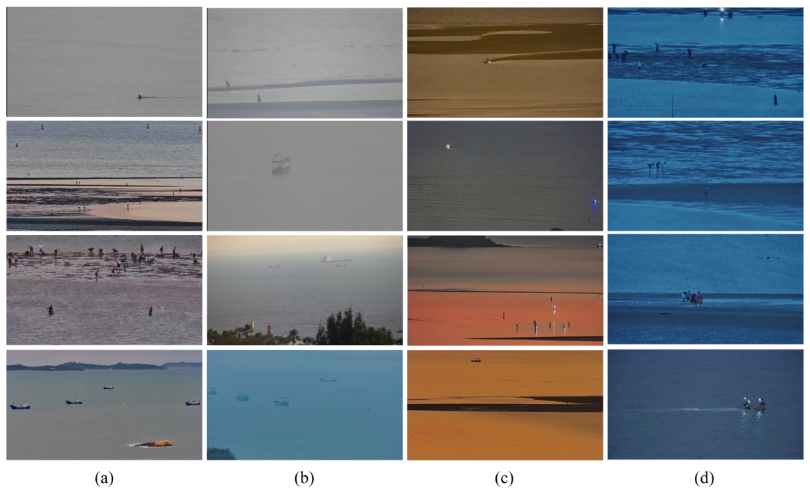
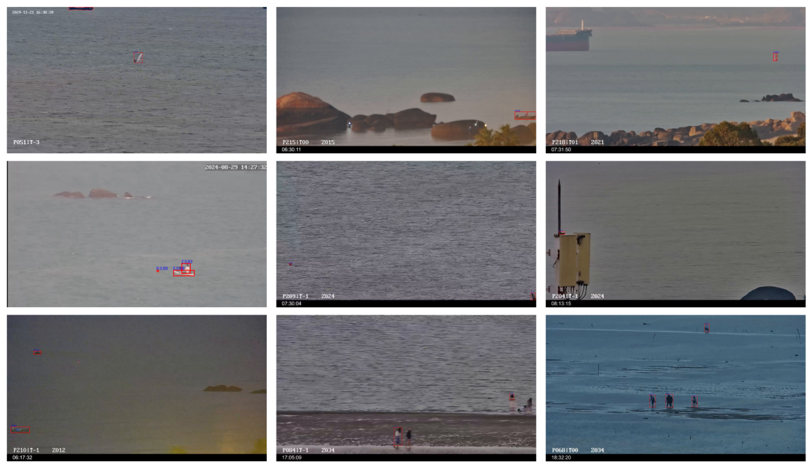
To solve this issue, this paper constructs a novel visible nearshore object detection dataset. The dataset comprises 20,934 images with 58,482 instances annotated using horizontal bounding boxes. Some examples of case presentations from our dataset are in
Figure 1.
The visible imagery constructed in this paper encompasses a wide range of real-world nearshore activities, providing a realistic representation of practical nearshore monitoring scenarios. To improve both the diversity and complexity of nearshore dataset, data acquisition was conducted under multiple environmental conditions. The representative characteristics of the collected data are summarized as follows: (1) Images acquired in diverse weather conditions. Weather variations have a significant influence on the visual quality of nearshore imagery. Adverse conditions, such as sea fog and rainfall, reduce image contrast and visibility while weakening object appearance, often resulting in darker scenes, blurred targets, and the loss of fine structural details. (2) Images captured under different illumination conditions. Changes in lighting conditions produce substantial variations in image brightness, contrast, and color distribution, even within the same observation area. Under strong sunlight, specular reflections from the sea surface may introduce local overexposure that conceals object features. Conversely, low-light or backlit environments reduce overall image brightness, making object boundaries less distinguishable and degrading feature discriminability. (3) Images collected from multiple viewing configurations. The dataset contains images acquired with different focal lengths, resulting in considerable variations in object scale and viewing geometry. Cameras equipped with long focal-length lenses can clearly image distant targets. By comparison, short focal-length lenses provide wider scene coverage but represent objects at much smaller scales, increasing the difficulty of detecting small targets.
3.2. Data Collection and Annotation
Visible imagery was acquired along the coastal areas of Fujian Province, China, between August 2024 and September 2025. The original image collection was subsequently refined through multiple stages of quality evaluation, during which visually repetitive samples and images containing limited useful information were excluded. This process yielded a visible nearshore object detection dataset including 20,934 images, which serves as the foundation for the subsequent benchmark and experimental evaluations.
The Make Sense, an online annotation tool, accessed in August 2024, was adopted for the annotation of ground-truth bounding boxes and the assignment of corresponding class identifiers. To guarantee the precision and consistency of annotations, three professional annotators independently performed the annotation tasks, followed by a mutual peer review process to identify and correct discrepancies. Subsequently, a single senior assessor conducted a comprehensive and unified evaluation of all annotated images, resolving all ambiguities to finalize the ground-truth annotations.
All images in the proposed dataset were initially annotated using the YOLO format, where each object instance is represented by its category label and normalized bounding-box coordinates. To facilitate the use of the dataset with different object detection frameworks, the annotations can also be conveniently converted into commonly used formats such as COCO.
Following the commonly adopted dataset partition strategy in object detection studies, as employed in Underwater Debris Detection Using YOLOV10 [
44], the proportions of the training, validation, and test sets were adjusted to 70%, 17%, and 13%. The relatively larger validation subset is intended to provide sufficient samples for robust model selection and hyperparameter optimization under the diverse conditions encountered in nearshore environments. The test subset is strictly excluded from all training and model-selection procedures and is used only for the final evaluation of model generalization. Specifically, images captured from the same continuous acquisition process or containing highly consistent environmental conditions were carefully reviewed to avoid being distributed across different subsets. Meanwhile, the three subsets were checked to ensure sufficient diversity in terms of acquisition time, illumination conditions, weather variations, viewpoints, and nearshore scenarios. Therefore, the final partition was further refined through manual screening to reduce the risk of scene and temporal information leakage.
3.3. Data Properties and Statistics
To ensure the diversity of imaging conditions and practical applicability, the images were acquired using multiple camera devices and captured under various focal lengths and observation distances. So the collected images exhibit various spatial resolutions, varying from 640 × 370 to 2560 × 1440 pixels. As summarized in
Table 2, approximately 46.7% of the images belong to the high-resolution categories, 32.4% of the images belong to the medium-resolution categories, while 15.1% are low-resolution samples. Such diversity in image resolution introduces substantial variations in scale, appearance, and scene complexity, making our dataset more representative of real-world nearshore scenarios and providing a challenging benchmark for object detection algorithms.
To illustrate the temporal distribution of the collected images, the dataset spans from August 2024 to September 2025, covering multiple quarters. As summarized in
Table 3, Q1 contributes the largest proportion of the dataset, accounting for 47.4% of all images, followed by Q4 with 29.9%. Q2 and Q3 account for 10.8% and 11.9% of the images, respectively. This temporal distribution provides variations in environmental conditions, illumination, and scene characteristics across different months and quarters, which is beneficial for developing and evaluating robust nearshore object detection algorithms.
As illustrated in
Figure 2, the objects are categorized into seven distinct categories, with a refined classification strategy tailored to the characteristics of nearshore scenarios. Vessels are classified into ship and boat. Humans are further categorized into pedestrian, sailor, and swimmer based on their spatial location and activity state in nearshore image: (1) Individuals located on beaches or coastal land areas are defined as pedestrians. (2) Individuals on board ships or boats are classified as sailors. (3) Individuals swimming in the sea or with more than half of their body submerged in seawater are identified as swimmers.
To improve annotation consistency, specific guidelines were established for human-related categories. Pedestrians are defined as people appearing on shorelines, beaches, piers, or coastal infrastructures. Sailors are defined as people located on boats or ships, including individuals operating, boarding, or standing on vessels. Swimmers are defined as people directly immersed in water and not associated with any floating platform or vessel. For occluded instances, annotations are assigned when the visible regions contain sufficient features to determine the category. When individuals are heavily overlapped by vessels, waves, or shoreline objects and their category cannot be confidently identified, they are not annotated. In addition, overlapping individuals are independently labeled whenever their locations and identities can be distinguished.
Small objects are prevalent in nearshore scenarios, accompanied by significant scale variations. Following general scale ranks [
7], objects occupying fewer than 32 × 32 pixels are classified as small-scale objects, those with pixel areas between 32 × 32 and 96 × 96 are categorized as medium-scale objects, and objects larger than 96 × 96 pixels are regarded as large-scale objects. This hierarchical classification enables precise characterization and quantitative analysis of the object scale distribution. As illustrated in
Table 4, small objects dominate the scale distribution of the dataset, collectively accounting for more than 47%, while medium and large objects account for approximately 42% and 11%, respectively. This distribution not only reflects the typical characteristic of nearshore scenarios where small and medium objects are predominant but also retains a reasonable proportion of large objects to ensure the dataset scale diversity and balance.
To provide a more comprehensive characterization of object scales under varying image resolutions, we further analyzed the relative object area of each annotated instance. Based on the relative object area ratio, the objects are further categorized into three scale levels: small objects (ratio ≤ 0.1%), medium objects (0.1% < ratio ≤ 1%) and large objects (ratio > 1%). Among all annotated instances, 31,210 objects occupy less than 0.1% of their corresponding image areas, accounting for 53% of the dataset, whereas 22,778 instances fall within the range of 0.1–1%, representing 39%. Only 4494 objects, corresponding to 8%, occupy more than 1% of the image area. Therefore, more than 92% of the annotated instances occupy less than 1% of their corresponding image areas, highlighting the prevalence of visually small targets in the proposed dataset.
Table 4 illustrates the number of annotated instances across different scale levels for each object category. All categories include numerous small objects, among which pedestrians, sailors, and swimmers are the primary contributors to small objects, making them the most challenging categories to detect in visible nearshore datasets. Due to long-range imaging conditions and the fact that swimmers are largely occluded by the water surface, swimmers cover only a limited image area, resulting in the absence of large objects in the dataset. In contrast, ships and boats exhibit the widest scale variation, which cover the full range from small to large objects, intuitively reflecting the diversity of object types and shooting distances in nearshore scenes. flotages and seamarks are also generally small in size, further increasing the difficulty of small object detection within the dataset. Overall, objects in visible nearshore datasets are mainly dominated by small and medium objects, accompanied by significant inter-category scale variation and a certain proportion of large objects, which collectively result in substantial detection challenges. This characteristic not only reflects the complexity of real-world nearshore environments but also provides highly valuable benchmark data for developing and evaluating small object detection algorithms.
4. Materials and Methods
4.1. Overall Framework of the Network
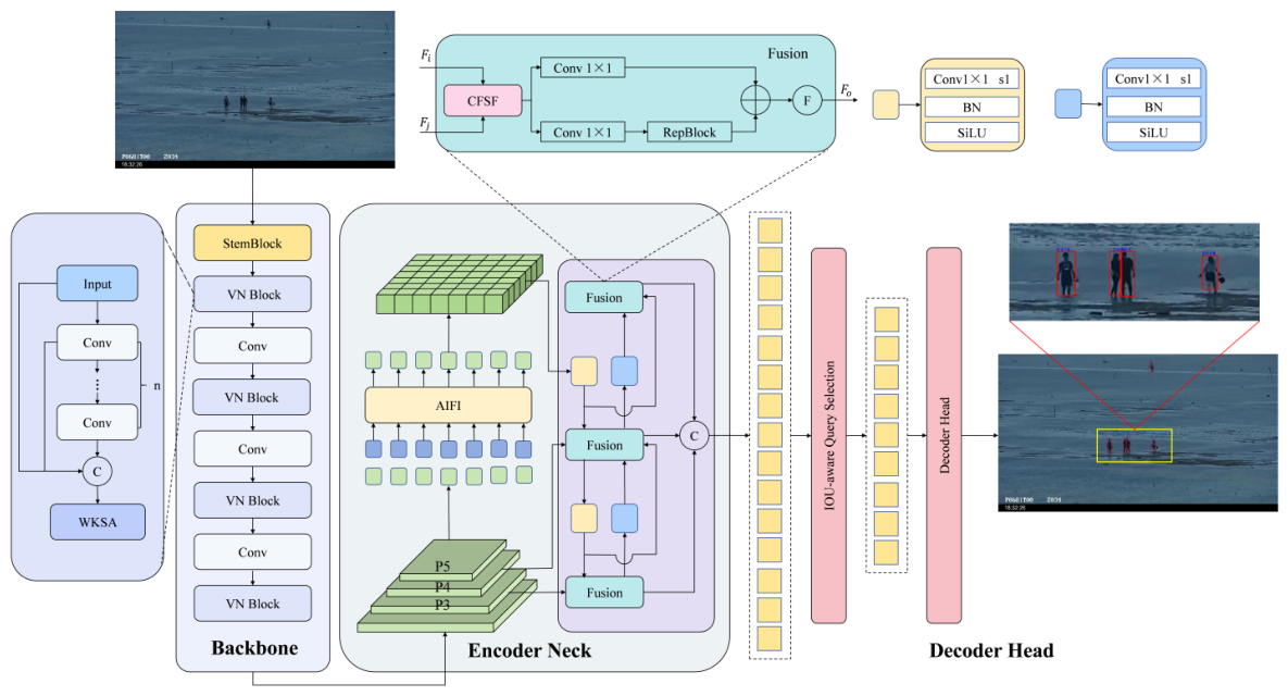
The overall framework of the proposed method is illustrated in
Figure 3. Specifically, we adopt DEIM as the baseline model. The kernel selective attention based on WTConv (WKSA) module enlarges the receptive field of the network, enabling more effective utilization of contextual information in visible images, which facilitates more accurate object classification. Furthermore, the cross-layer feature selection and fusion (CFSF) module performs matching, selection, and fusion of features from adjacent levels, which enhances the discriminability between objects and background in nearshore scenes. As a result, the proposed method improves the detection performance for small objects, weak-texture objects, as well as objects affected by wave reflections and shoreline texture interference.
4.2. Kernel Selective Attention Based on WTConv
In visible nearshore object detection, the background textures and significant differences in object scales makes small objects prone to being obscured under strong reflections or low-contrast conditions. Traditional convolutional neural networks, constrained by fixed-size kernels, fail to capture sufficient contextual information, making false detections or missed detections of small objects. Existing methods are generally limited by a fixed and restricted receptive field and lack the capacity to dynamically adjust it for different types of objects. To solve these issues, we propose the WKSA module, which integrates wavelet convolutions with a dual branch attention mechanism to effectively expand the receptive field.
Given an input feature , the two-dimensional Haar Wavelet Transform is implemented by applying four predefined wavelet kernels through depth-wise convolution with a stride of 2. Among these kernels, a low-pass filter and three high-pass filters capture features at different frequency bands. Consequently, the input is decomposed into four components, including the low-frequency component and the horizontal, vertical, and diagonal high-frequency components.
We used the 2D Haar wavelet in the WKSA module mainly because of its computational efficiency, strong localization capability, and suitability for extracting fine-grained spatial information. The Haar wavelet can be implemented efficiently with simple filtering and downsampling operations. This property is particularly beneficial for object detection networks, where preserving a favorable balance between feature representation capability and computational complexity is important.
To alleviate the trade-off between convolutional kernel size and the number of parameters, WTConv [
45] performs a wavelet transform on the input features, decomposing them into low-frequency and high-frequency components. These features are then filtered and downsampled. Subsequently, small 3 × 3 convolutional kernels are applied independently to each sub-band. Finally, the inverse wavelet transform is utilized to reconstruct and fuse the outputs. The overall process can be summarized as follows:
where
denotes the input feature, while
W denotes the weight tensor of a k × k depth-wise convolution kernel with an input channel dimension equal to four times that of
. Moreover,
WT and
IWT represent the wavelet transform and its inverse operation, respectively.
WTConv first employs wavelet transform to decompose the input features into one low-frequency sub-band and multiple high-frequency sub-bands. During this process, the spatial resolution of the feature maps is downsampled to half of the original, while each sub-band still retains structural information across different frequency domains. Since subsequent convolution operations are performed within these downsampled sub-band spaces, a convolution kernel of a given size corresponds to a larger region in the original feature map, which effectively enlarges the receptive field. This design enables the network to capture both local and global features of objects in visible nearshore images, overcoming the limitation of conventional convolutions that primarily focus on local information.
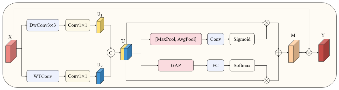
The structure of WKSA is illustrated in
Figure 4. Given an input feature map
, it is first processed by a 3 × 3 depth-wise convolution and a WTConv in parallel to generate features with different receptive fields. Subsequently, each branch is followed by a 1 × 1 convolution to integrate channel information and unify the feature dimensions, producing contextual features
and
with diverse receptive fields. Finally, the features obtained from different branches are concatenated along the channel dimension to form the aggregated feature
.
where
and
denote a 1 × 1 convolution and 3 × 3 convolution. WTConv denotes wavelet convolution.
Considering that different types of objects require contextual information at varying scales, a spatial-channel selection mechanism is introduced to enhance the dynamic adaptability of the network. Specifically, spatial relationships are extracted from the output features using both average pooling and max pooling operations. The pooled features are then concatenated and processed by a 1 × 1 convolution layer, followed by a sigmoid activation function to generate the spatial attention map
. The spatial selection can be formulated as follows:
where AvgPool and MaxPool represent average pooling and max pooling operations.
denotes sigmoid activation function.
To effectively compute channel attention, global average pooling is employed to compress the spatial dimensions of the feature map. Subsequently, a fully connected layer is utilized to produce channel attention features. This is followed by a Softmax operation to generate channel attention map
, which are then used to guide the selection process. The channel selection can be formulated as follows:
The enhanced feature maps are weighted using spatial-channel selection weight. These weighted maps are then combined via the 1 × 1 convolutional layer. The attention feature
can be expressed as
The WKSA module generates its final output by performing an element-wise multiplication between the input feature X and M:
For small objects, the limited number of pixels makes their feature representations particularly vulnerable to information loss during successive feature extraction and downsampling operations. The WKSA module mitigates this issue through wavelet-based feature decomposition, which separates the input features into low-frequency and high-frequency components. While the low-frequency component preserves the global structural information, the high-frequency components retain fine-grained details, such as object boundaries and local texture patterns. These detailed representations are particularly beneficial for distinguishing small targets from complex nearshore backgrounds. Moreover, the kernel selection mechanism adaptively aggregates contextual information from different receptive fields, allowing the network to balance local detail preservation and broader contextual modeling. Consequently, WKSA enhances the discriminability of small-object features while reducing interference from surrounding background regions.
4.3. Cross-Layer Feature Selection and Fusion
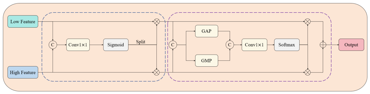
In the features extracted by the backbone network, shallow layers typically preserve abundant edge information and texture details, whereas deeper layers encode semantic representations. However, such semantic features are often accompanied by blurred boundaries and a reduced capability to represent small objects. To effectively integrate multi-scale information, enhance the consistency modeling of foreground regions and suppress background noise interference, we propose a cross-layer feature selection and fusion module, as illustrated in
Figure 5. The spatial and channel matching between features from different layers are first computed, and the matching results are then utilized to perform adaptive weighting on the input features. By jointly leveraging spatial correlations and semantic associations, the proposed method adaptively mitigates discrepancies across multi-scale features and effectively suppresses noise interference, enabling more robust feature representation.
For the features from different layers , denotes the guidance features from the cross-layer branch, while represents the features at the current scale to be fused.
First, the two feature branches are concatenated, followed by a 1 × 1 convolution to generate spatial weight
, which is subsequently normalized using the sigmoid activation function.
Next, we split
into two parts
and
. Subsequently,
and
will be multiplied by the corresponding
and
to obtain the weighted feature maps
and
.
The spatially filtered features are concatenated to obtain feature
, followed by the application of global average pooling and global max pooling. The pooled features are then concatenated and passed through a 1 × 1 convolution, after which a Softmax function is employed to generate channel weights
.
Subsequently,
and
will be multiplied by the corresponding
and
to obtain the weighted feature maps
and
. Finally, we perform element-wise addition between
and
to achieve feature fusion and obtain
, which serves as the output of the CFSF block.
In nearshore scenarios, challenges such as wave reflections, complex shoreline textures, and weak texture characteristics of small objects at long distances often cause multi-scale fusion strategies to propagate excessive background details into subsequent detection stages. The proposed cross-layer feature selection and fusion module focuses on the complementary information across multi-scale features, enabling spatial-aware feature refinement among features of different scales while achieving semantic complementarity. This method enables high-level semantic features to selectively emphasize low-level texture details that are truly relevant to object regions, while low-level spatial features are enhanced only when they are consistent with high-level semantic representations. CFSF performs selective cross-layer feature interaction and fusion, enabling complementary information from different feature levels to be adaptively integrated. Through this mechanism, fine spatial details can be preserved for small objects, while high-level semantic and contextual information can be effectively exploited for larger objects. As a result, the proposed module effectively improves the consistency of multi-scale features for small objects while suppressing the accumulated propagation of background interference within the feature pyramid. Consequently, it enhances the model’s capability to detect small-scale and low-contrast objects.
5. Results
In this section, we present an evaluation of the proposed nearshore dataset. The dataset is divided into training, validation and test sets. Based on this division, we train ten object detection algorithms and compare their performance against that of our proposed approach on the test set.
5.1. Experiments Setup
The model is trained on a computing platform with an NVIDIA V100 GPU. The experiment was performed using the widely adopted PyTorch 2.2.0 framework, which has been well acknowledged for its flexibility and computational efficiency, with python 3.10 and CUDA 11.8 environment. In our network configuration, the batch size was set to 8, and the input image resolution was fixed at 640 × 640 pixels. The training was conducted for a total of 132 epochs using the AdamW optimizer.
5.2. Evaluation Metrics
To comprehensively assess detection performance, precision (P), recall (R), mean Average Precision (mAP), model parameters, and frames per second (FPS) are adopted as the evaluation metrics. Precision quantifies the ratio of correctly detected objects to all predicted detections, whereas recall indicates the fraction of ground-truth objects that are successfully identified. The relationship between these two metrics is illustrated by the precision–recall (PR) curve, whose enclosed area corresponds to the Average Precision (AP) for an individual category. Averaging the AP values across all categories yields the mean Average Precision (mAP). Specifically, mAP50 is computed at an Intersection over Union (IoU) threshold of 0.5, while mAP50:95 is obtained by averaging AP over IoU thresholds ranging from 0.50 to 0.95 with an interval of 0.05. The number of model parameters is reported to reflect the computational complexity and memory demand of each detector. In addition, inference efficiency is measured by frames per second (FPS), which indicates the number of image frames processed by the detector each second and serves as an indicator of real-time performance.
5.3. Comparisons of Performance
A quantitative evaluation of the proposed approach against several state-of-the-art object detection methods on the visible nearshore dataset is presented in
Table 5. For objective evaluation, all detectors are trained from their official implementations using the original default training schedules and hyperparameter configurations, ensuring a fair and reproducible comparison. Faster R-CNN achieves an mAP50 of 65.4%, indicating relatively limited detection performance. Although the single-stage method YOLOv13 has a smaller number of parameters, its mAP50 is only 62.8%, suggesting insufficient capability in handling complex nearshore scenarios. Transformer-based methods in the RT-DETR series exhibit overall superior performance, among which RT-DETRv3 achieves 77.8%, showing a clear improvement over RT-DETR. D-FINE and DEIM achieve mAP50 scores of 73.8% and 77.4%, respectively, demonstrating competitive performance with relatively low parameter counts. The proposed VN-DETR achieves the best performance, with an mAP of 80.5%, exceeding the baseline DEIM by 3.1%. This improvement indicates that the proposed method possesses stronger overall detection capability in complex nearshore environments.
From the perspective of per-class detection performance, VN-DETR achieves best performance across most categories and shows significant advantages in detecting small-scale and weak-feature objects. For the swimmer category, VN-DETR attains 45.1% which is the highest. For the pedestrian, it achieves 56.2%, approaching the best result of RT-DETRv3 of 57.6% and significantly outperforming other methods. These results show that the VN-DETR can effectively extract features under small-scale and complex background conditions. For ship and boat, VN-DETR obtains the best results of 98.4% and 98.2%, respectively, indicating improved localization accuracy while maintaining high recall. Moreover, for challenging categories such as flotage and seamark, which are frequently influenced by reflections on the sea surface and background clutter, VN-DETR achieves 83.7% and 98.1%, outperforming DEIM. These results further validate the effectiveness of the proposed method for visible nearshore object detection tasks.
In terms of model complexity, VN-DETR contains 17.7 M parameters. Although this is higher than the YOLO series, it yields a substantial improvement in detection accuracy. Compared with the RT-DETR series, VN-DETR achieves better detection performance while using fewer parameters. GFLOPs represents the number of floating-point operations required for processing a single input image. To further assess the computational complexity of the compared methods, GFLOPs is introduced as an additional evaluation metric. The proposed VN-DETR requires 36.2 GFLOPs for processing a single input image. Although its computational cost is higher than that of lightweight detectors such as YOLOv13, D-FINE and DEIM, VN-DETR remains considerably less computationally demanding than several Transformer-based detection methods, including RT-DETR, RT-DETRv2, RT-DETRv3, and OWRT-DETR. This demonstrates a favorable trade-off between accuracy and model complexity. Overall, VN-DETR demonstrates outstanding performance on the visible nearshore dataset, with particularly notable advantages in small object detection tasks such as swimmer. Meanwhile, it achieves an effective trade-off between accuracy and model complexity, making it well-suited for visible nearshore object detection applications.
In terms of inference efficiency, the proposed VN-DETR achieves an inference speed of 35.6 FPS while maintaining the highest overall detection accuracy. Compared with RT-DETR series and DEIM, VN-DETR exhibits lower inference speed due to the introduction of additional feature enhancement modules, which inevitably increase computational complexity. Nevertheless, the proposed method still satisfies real-time processing requirements in practical nearshore surveillance scenarios. Notably, the inference speed is evaluated based on single-frame processing and measured on an NVIDIA V100 GPU, reflecting the sequential processing of continuous video streams in realistic deployment. These results demonstrate that VN-DETR provides a trade-off between detection accuracy and inference speed, making it well-suited for complex visible nearshore object detection tasks requiring both robustness and real-time performance.
To comprehensively evaluate the robustness of different detectors under significant scale variations, APS, APM, and APL are adopted as scale-based evaluation metrics. Following the COCO evaluation protocol, these metrics represent the average precision of small-, medium-, and large-scale objects, respectively, calculated under the mAP50:95 criterion by averaging the results over IoU thresholds ranging from 0.50 to 0.95 with a step size of 0.05. These scale-based metrics provide a comprehensive assessment of the ability of different detectors to handle multi-scale object distributions in complex nearshore environments.
Table 6 presents a detailed scale-based evaluation of different detectors, including small-, medium-, and large-scale object detection performance. It can be observed that VN-DETR achieves superior performance across different object scales, demonstrating its effectiveness in handling the significant scale variations in nearshore scenarios. Specifically, VN-DETR obtains an AP
S of 46.3%, which surpasses YOLOv13, RT-DETRv3, D-FINE, and DEIM by 13.9%, 7.0%, 7.1%, and 3.5%, respectively. This improvement indicates that the proposed model can effectively enhance the representation capability of small objects, which are frequently affected by complex backgrounds, and severe occlusions in nearshore environments.
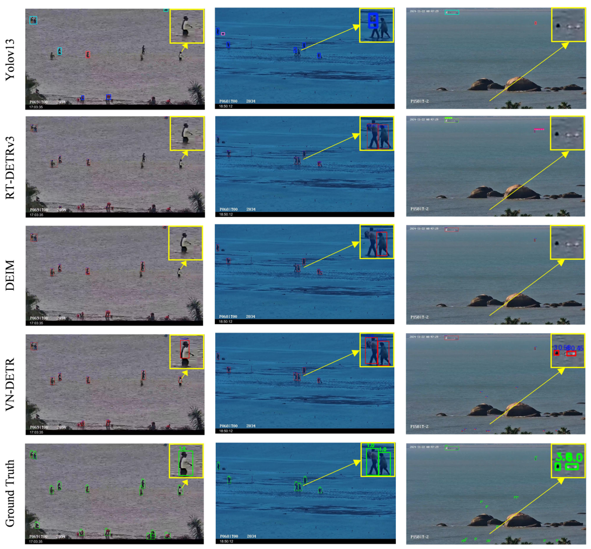
Our proposed model not only demonstrates superior performance in terms of mAP evaluation, it also achieves significant improvements in perceptual quality. As illustrated in
Figure 6, we present visualizations of detection results from YOLOv13, RT-DETRv3, DEIM, and our proposed VN-DETR. The evaluation figure clearly highlights the notable enhancement in perceptual quality. In visible nearshore images, significant scale variations often cause objects to be reshaped into small objects, while illumination conditions further degrade texture details and make feature representation ambiguous. The baseline methods suffer from misclassification and missed detections, particularly exhibiting poor performance in pedestrian. In contrast, the VN-DETR is still capable of accurately detecting pedestrians even under scale variations and severe loss of texture details. This demonstrates the superiority of the proposed method in handling challenging conditions and highlights its robustness in complex visible nearshore scenarios.
To further evaluate the effectiveness and generalization capability of the proposed VN-DETR, extensive comparisons are conducted with representative object detection methods on the SeaDronesSee dataset. The results are shown in
Table 7.
The proposed VN-DETR achieves the best detection performance among all compared methods, obtaining an mAP50 of 84.9%, which surpasses the second-best method DEIM by 2.4%. This improvement demonstrates that the proposed model can effectively capture discriminative representations from complex maritime environments. In particular, SeaDronesSee contains numerous small-scale and low-contrast targets affected by illumination variations, background interference and scale changes. The superior performance of VN-DETR indicates that the proposed feature enhancement strategy can better exploit multi-scale contextual information and improve target localization and recognition capability in challenging scenarios.
5.4. Ablation Experiments
A comprehensive ablation analysis is performed on the visible nearshore dataset to examine the effectiveness of the proposed modules. The contribution of each module is measured using mAP50, mAP50:95, and model parameter. The results are summarized in
Table 8, the modules are progressively incorporated into the baseline detector to evaluate the kernel selective attention based on WTConv and cross-layer feature selection and fusion module.
Compared with the baseline model, we achieve an mAP50 of 78.7% by introducing the kernel selective attention based on WTConv, leading to a 1.3% improvement. This demonstrates that the proposed WKSA module effectively processes the varying wide context of the objects being detected, enabling the model to capture discriminative features and enhancing detection performance. When only the cross-layer feature selection and fusion module is integrated into the baseline network, the mAP50 increases to 79.2%, corresponding to improvements of 1.8%. This improvement can be attributed to the proposed CFSF module to selectively preserve semantically consistent regions across multiple feature levels, enhancing feature representation while retaining fine-grained details of small objects, which ultimately leads to improved overall detection performance. By simultaneously incorporating both the WKSA and CFSF modules, VN-DETR achieves the best performance, reaching an mAP50 of 80.5%. Compared with the baseline, the overall improvements are 3.1%. Overall, the experimental evaluation shows that the enhancements consistently improve detection accuracy with minimal additional parameter overhead, underscoring the effectiveness of VN-DETR for visible nearshore object detection.
To further verify the superiority of the proposed WKSA and CFSF modules over other methods with similar functions, we have added additional comparative experiments with dynamic convolution (DConv) [
49] and a multi-scale feature fusion approach hierarchical feature fusion encoder (HFFE) in HAFNet [
50].
As shown in
Table 8, introducing DConv into the baseline model improves the mAP50 from 77.4% to 78.1%, demonstrating that dynamic convolution can enhance feature representation by adaptively adjusting convolutional kernels according to input features. Meanwhile, HFFE improves the baseline performance to 78.2% mAP50, indicating that multi-scale feature fusion can effectively aggregate information from different resolutions and improve the detection capability of objects with diverse scales. However, the proposed WKSA and CFSF modules achieve stronger performance improvement. By combining WKSA and CFSF, VN-DETR achieves the best performance of 80.5% mAP50.
DConv dynamically adjusts convolutional kernels according to input features, which improves feature adaptability. However, it mainly focuses on local feature transformation and has limited capability in capturing long-range contextual information. HFFE enhances multi-scale representation through feature aggregation, but the fusion process may introduce redundant background information in complex nearshore environments. In contrast, WKSA leverages wavelet decomposition and kernel selective attention to capture multi-scale contextual dependencies, while CFSF performs adaptive cross-layer feature selection to preserve discriminative details. These complementary designs enable VN-DETR to achieve more effective feature representation for small, densely distributed, and highly variable nearshore objects.
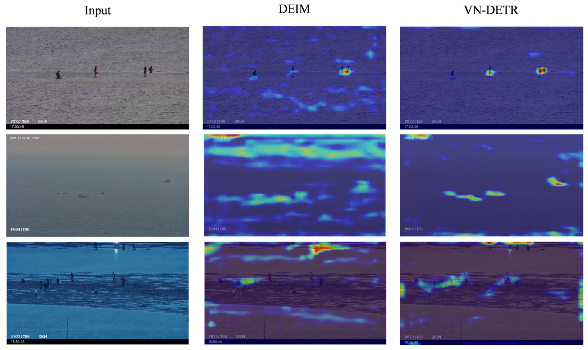
To further evaluate the proposed model, gradient-weighted class activation mapping (Grad-CAM) [
51] is employed to generate heatmaps for qualitative analysis. As illustrated in
Figure 7, insightful visual results are presented across different scenarios. The DEIM model is significantly affected by background noise, which limits its ability to accurately focus on target regions. In contrast, the VN-DETR enlarges the receptive field and optimizes cross-layer feature fusion, enabling it to attend to targets more effectively. Especially, in the third row of detection results, the baseline model struggles to detect pedestrians because of the low contrast between the pedestrians and beach. However, the proposed method VN-DETR is less susceptible to background interference and demonstrates superior detection performance.
6. Discussion
The visible nearshore object detection studied in this paper is an extremely challenging task. As shown in
Figure 8, the observed failure cases on the visible nearshore dataset primarily stem from the following reasons: (1) Extremely small object sizes and significantly limited appearance features severely constrain feature representation learning, leading to high rates of missed detections and false alarms. (2) Severe occlusion and object motion blur cause algorithms to lose objects in certain images, resulting in missed detections. (3) Variations in illumination and weather conditions induce different features among objects of the same category, challenging the robustness of the detection methods. (4) In marine environments, sea clutter introduces substantial background noise, which frequently triggers false detections. (5) Class imbalance introduces training bias, which constrains detection performance for categories with fewer instances. For instance, the number of ship instances is substantially larger than that of swimmer instances. Such long-tail distribution introduces training bias toward dominant categories and limits the detection performance of minority categories, particularly small-scale swimmers under complex sea-surface interference.
The experimental results on the proposed visible nearshore dataset provide several important insights into both dataset characteristics and model design, particularly when interpreted in the context of existing studies.
In the visible nearshore datasets, most existing datasets predominantly focus on single-category tasks such as ship detection. As discussed in
Section 2, such datasets often suffer from insufficient scene diversity, coarse-grained annotations, and severe class imbalance. In contrast, the proposed visible nearshore dataset introduces a more comprehensive representation by jointly modeling humans, vessels, and floating objects under complex nearshore conditions. Experimental evaluations indicate that existing state-of-the-art detectors exhibit clear performance degradation when directly applied to this dataset, which is consistent with previous findings that domain shift and scene-specific characteristics significantly affect detection performance. This validates that nearshore environments require dedicated datasets and specialized model designs.
In the visible nearshore methods, the superiority of VN-DETR over both YOLO series and RT-DETR variants detectors highlights the importance of explicitly addressing small object dominance and background interference. Existing studies have shown that Transformer-based methods are effective in modeling global context but often struggle with small objects due to insufficient fine-grained feature representation. The improvements observed in VN-DETR, particularly in challenging categories such as swimmers, confirm that enlarging the receptive field and enhancing cross-scale feature consistency can significantly improve detection robustness. The ablation experiments further demonstrate the contribution of each proposed module. The WKSA module contributes to performance gains by expanding the receptive field and capturing broader contextual information. Meanwhile, the CFSF module further improves performance by selectively fusing semantically consistent features across layers, effectively suppressing background noise propagation.
This study has important implications for real-world applications. Accurate detection of nearshore objects is critical for maritime safety, water rescue and intelligence surveillance systems. The demonstrated improvements in detecting low-contrast and tiny objects indicate that the proposed approach has strong potential for deployment in practical monitoring systems. Moreover, we provides a valuable visible nearshore object detection benchmark for future research, facilitating the development and fair comparison of algorithms tailored to nearshore environments.
Overall, the results not only validate the effectiveness of the dataset and VN-DETR model but also highlight key challenges and opportunities in visible nearshore object detection.
7. Conclusions
This paper presents a task termed visible nearshore object detection, which aims to improve the detection performance of pedestrians, sailors, swimmers, ships, boats, flotages, and seamarks in visible nearshore scenarios. To advance research in this field, we construct a large-scale visible nearshore dataset. The dataset provides fine-grained categorization of human-related objects and includes annotations with horizontal bounding boxes. The dense annotations significantly enhance its value as a benchmark for visible nearshore object detection. Our proposed dataset has the potential to make substantial contributions to related research areas, including visible nearshore object detection, person re-identification, and pedestrian counting. Furthermore, we propose a novel detection algorithm named VN-DETR, which integrates kernel selective attention based on WTConv (WKSA) and the cross-layer feature selection and fusion module (CFSF) to effectively address the challenges of this task. Extensive experiments demonstrate the superiority and effectiveness of the VN-DETR. In future, we plan to explore additional tasks on the proposed dataset, such as visible nearshore multi-object tracking. We will also further expand the dataset by incorporating more diverse scenarios and finer-grained ship categories, promoting continued progress in visible nearshore object detection. Future studies will investigate class-balanced optimization and data augmentation techniques to alleviate the long-tail distribution problem in visible nearshore datasets.
Although the proposed VN-DETR achieves promising performance in visible nearshore object detection, it still exhibits certain limitations in complex and unseen real-world scenarios. When the VN-DETR model trained on a source domain dataset is deployed to unseen real-world target domain data, its generalization ability typically degrades due to domain shift. In future work, we will focus on developing more effective designs to enhance the cross-domain generalization ability of the proposed model. In addition, we plan to further investigate fusion methods for visible and infrared image in nearshore scenarios. We are currently constructing a new large-scale infrared nearshore dataset. Compared with the current visible dataset, the new dataset is expected to provide complementary information under challenging conditions such as low illumination, nighttime environments, and complex weather conditions. By leveraging multi-source datasets and integrating the complementary features of visible and infrared modalities, we aim to further improve the effectiveness and robustness of nearshore object detection algorithms. In addition, UAV-based observation offers more flexible viewing angles, wider observation ranges, and aerial perspectives, and it can potentially capture a larger number of small-scale and densely distributed targets. Therefore, UAV-acquired data could further enrich the diversity of object scales, viewpoints, and scene characteristics. In future work, we plan to incorporate more UAV-based imagery as a valuable supplement to the current fixed-camera dataset and investigate the integration of multi-platform data for more comprehensive nearshore object detection.
In future work, improving the efficiency will be an important research direction. First, the proposed modules could be further optimized through lightweight convolutional operators, efficient attention mechanisms, or adaptive feature selection, such that computationally expensive operations are selectively activated according to the complexity of the input scene. Second, structured pruning could be explored to remove redundant channels and feature interactions while preserving the most informative representations. Third, knowledge distillation could be employed to transfer the discriminative capability of the current VN-DETR to a more compact student model, reducing computational complexity with minimal degradation in detection accuracy. These strategies may facilitate the development of a lightweight VN-DETR variant that maintains strong small-object detection capability while being more suitable for real-time deployment in practical nearshore surveillance systems.




 ,
,