Improving Backscatter-Based Surface Water Classification in Arid Environments Through Interferometric Coherence

Highlights
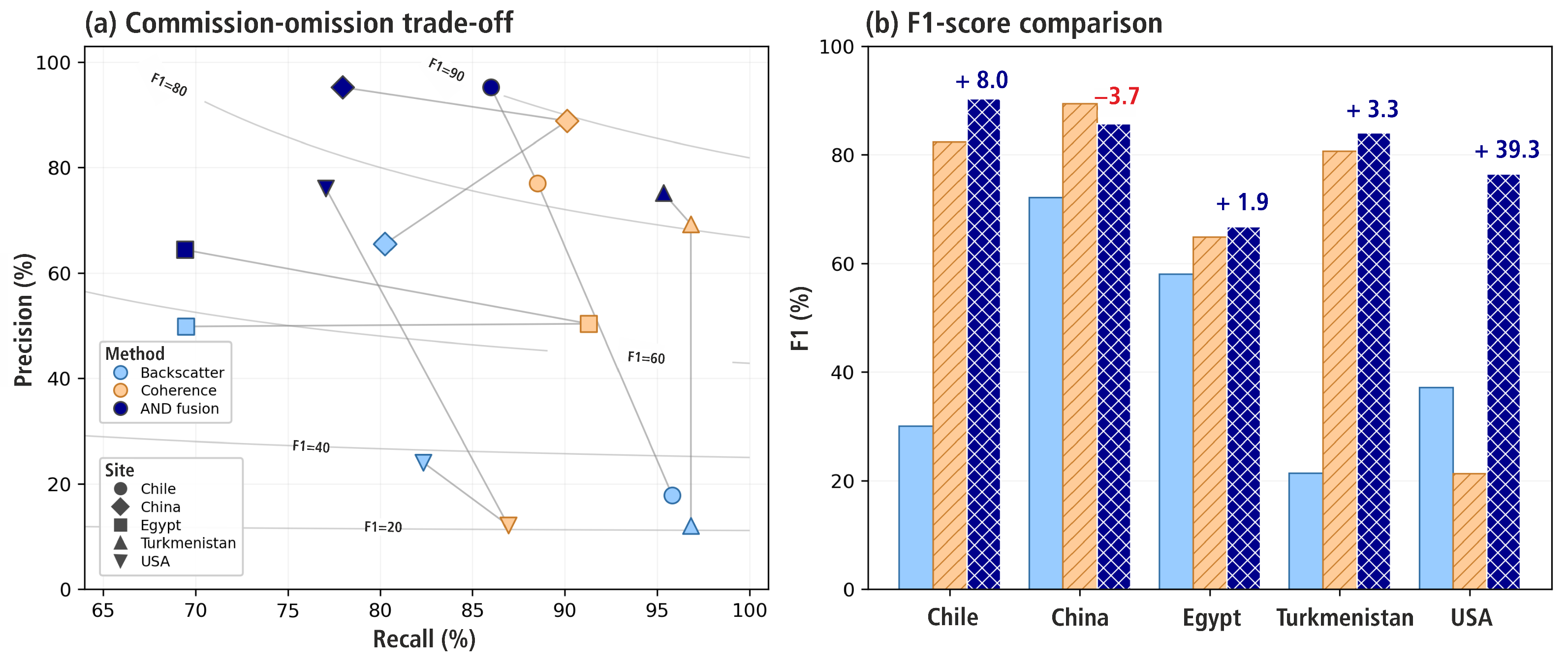
- Coherence Global 1-year interferometric coherence composites significantly outperform backscatter for permanent water detection in arid environments.
- Minimal overlap in detection failures proves strong complementarity between coherence and backscatter across all test sites.
- Integrating coherence datasets will directly enhance the performance of global water monitoring services.
- Upcoming NISAR Analysis Ready Data (ARD) will drastically simplify integration into existing operational pipelines.
Abstract
1. Introduction
2. Materials and Methods
2.1. Global Coherence and Backscatter Data
2.2. Auxiliary Datasets
2.3. Annual Compositing, Correlation Analysis and Water Detection
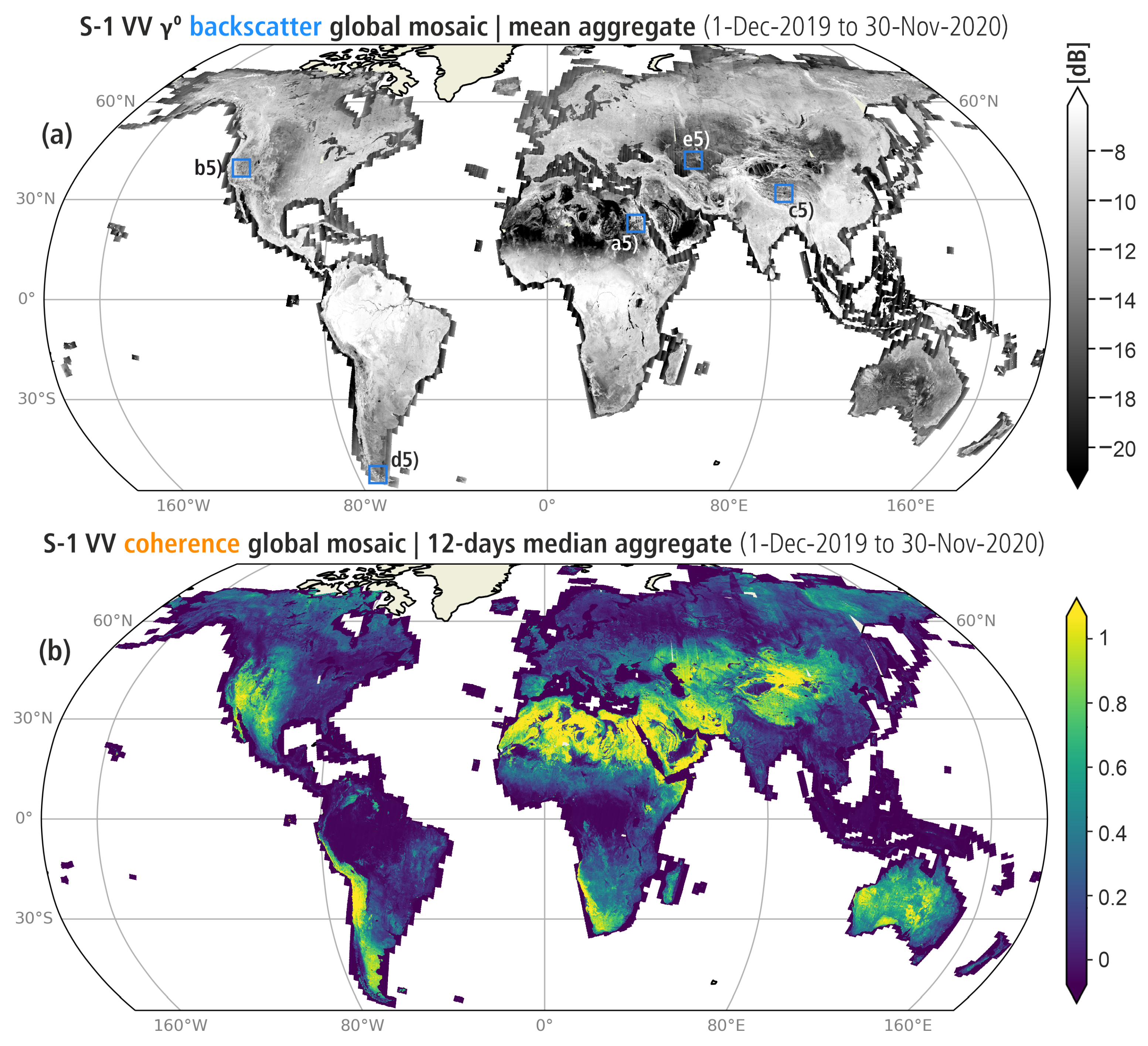
- We reprojected the annual composite datasets into the Equi7 Grid [25] at a 500 m pixel sampling and then selected five T3 Equi7 tiles ( km) overlapping our study areas to obtain a constant spatial extent and equal pixel count across all sites. Equi7 was selected for its ability to preserve geometric accuracy and minimize data oversampling across diverse latitudes.
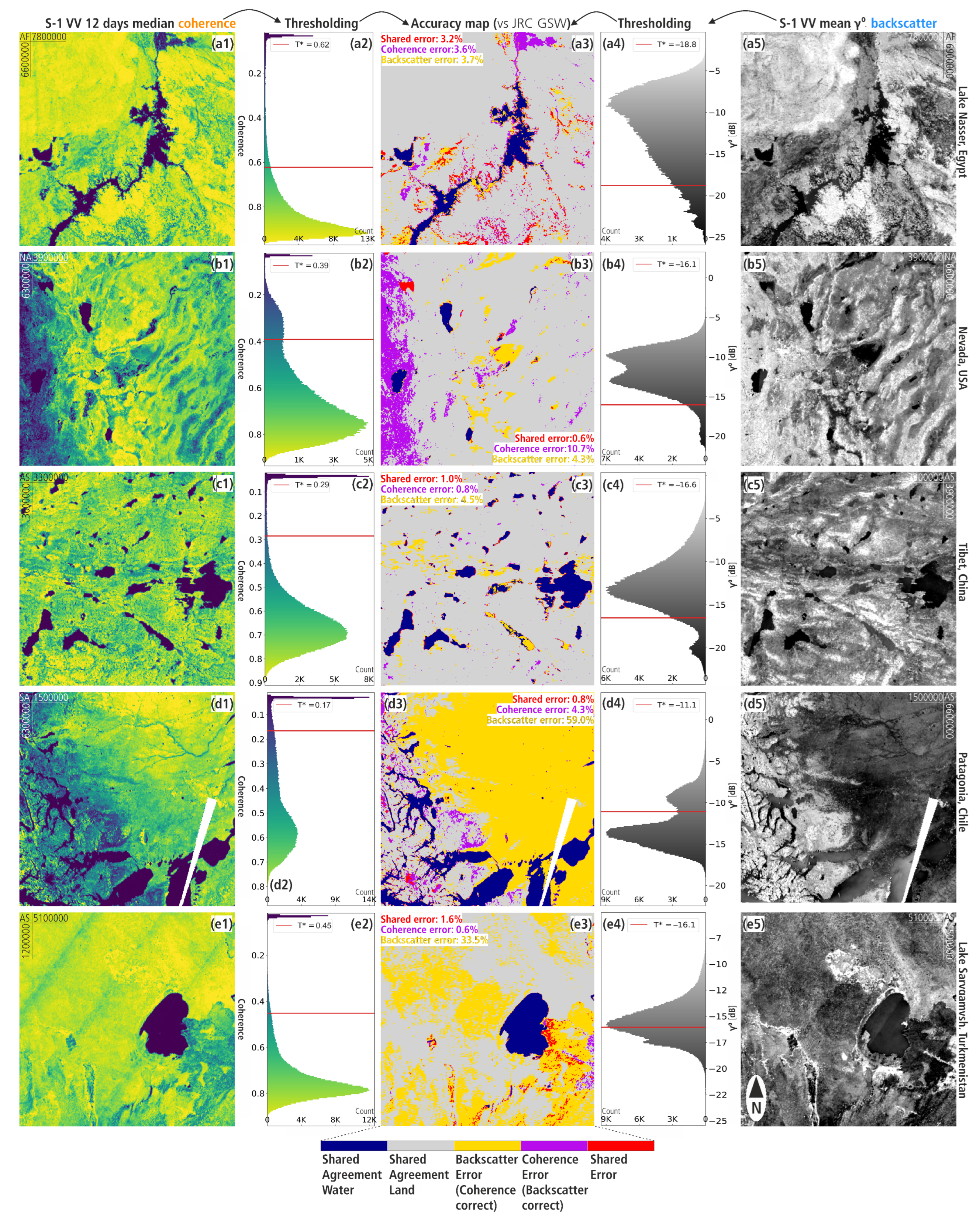
- Each input tile was subdivided into a regular grid of 128 × 128 pixel sub-tiles, and candidate sub-tiles exhibiting bimodal distributions were identified using Sarle’s bimodality coefficient [26] and Ashman’s D statistic [27]. A sub-tile is accepted here if or , preserving small water bodies with weak secondary modes. Ashman’s D was derived from a 128-bin histogram using modal widths for standard deviations. For each accepted bimodal sub-tile, a local threshold was estimated via the Kittler–Illingworth minimum-error criterion [28], which fits two Gaussian distributions to the histogram and finds the threshold minimizing total misclassification error. A robust global threshold was then derived using a 10% trimmed mean (active when ≥11 sub-tiles are accepted, defaulting to an arithmetic mean otherwise), and pixels below were classified as water.
3. Results
3.1. Global Coherence and Backscatter Signatures for Land Cover Classes
3.2. Assessing SAR Backscatter and Coherence for Water Mapping in Arid Areas
4. Discussion
5. Conclusions
Author Contributions
Funding
Data Availability Statement
Acknowledgments
Conflicts of Interest
Abbreviations
| SAR | Synthethic Aperture Radar |
| S1 | Sentinel-1 |
| LC | Land Cover |
| DSWx | Dynamic Surface Water eXtent |
| GFM | Global Flood Monitoring |
| EO | Earth Observation |
| InSAR | Interferometric SAR |
| LULC | Land use/land cover |
| RTC | Radiometric terrain-corrected |
| JRC | Joint Research Center |
| GSW | Global Surface Water |
| FP | False Positive |
| FN | False Negative |
| TP | True Positive |
| TN | True Negative |
References
- World Meteorological Organization. State of Global Water Resources 2024; Technical report; World Meteorological Organization: Geneva, Switzerland, 2025. [Google Scholar] [CrossRef] [Scilit]
- Chandanpurkar, H.A.; Famiglietti, J.S.; Gopalan, K.; Wiese, D.N.; Wada, Y.; Kakinuma, K.; Reager, J.T.; Zhang, F. Unprecedented Continental Drying, Shrinking Freshwater Availability, and Increasing Land Contributions to Sea Level Rise. Sci. Adv. 2025, 11, eadx0298. [Google Scholar] [CrossRef] [Scilit]
- McCabe, M.F.; Rodell, M.; Alsdorf, D.E.; Miralles, D.G.; Uijlenhoet, R.; Wagner, W.; Lucieer, A.; Houborg, R.; Verhoest, N.E.C.; Franz, T.E.; et al. The Future of Earth Observation in Hydrology. Hydrol. Earth Syst. Sci. 2017, 21, 3879–3914. [Google Scholar] [CrossRef] [Scilit]
- Tottrup, C.; Druce, D.; Meyer, R.P.; Christensen, M.; Riffler, M.; Dulleck, B.; Rastner, P.; Jupova, K.; Sokoup, T.; Haag, A.; et al. Surface Water Dynamics from Space: A Round Robin Intercomparison of Using Optical and SAR High-Resolution Satellite Observations for Regional Surface Water Detection. Remote Sens. 2022, 14, 2410. [Google Scholar] [CrossRef] [Scilit]
- OPERA. OPERA Dynamic Surface Water Extent from Sentinel-1 Version 1; NASA Physical Oceanography Distributed Active Archive Center (PO.DAAC): Pasadena, CA, USA, 2024. [Google Scholar] [CrossRef]
- Wagner, W.; Bauer-Marschallinger, B.; Roth, F.; Raiger-Stachl, T.; Reimer, C.; McCormick, N.; Matgen, P.; Chini, M.; Li, Y.; Martinis, S.; et al. The Fully-Automatic Sentinel-1 Global Flood Monitoring Service: Scientific Challenges and Future Directions. Remote Sens. Environ. 2026, 333, 115108. [Google Scholar] [CrossRef] [Scilit]
- Showstack, R. Sentinel Satellites Initiate New Era in Earth Observation. EoS Trans. 2014, 95, 239–240. [Google Scholar] [CrossRef] [Scilit]
- Bauer-Marschallinger, B.; Cao, S.; Tupas, M.E.; Roth, F.; Navacchi, C.; Melzer, T.; Freeman, V.; Wagner, W. Satellite-Based Flood Mapping through Bayesian Inference from a Sentinel-1 SAR Datacube. Remote Sens. 2022, 14, 3673. [Google Scholar] [CrossRef] [Scilit]
- Festa, D.; Hassaan, M.; Wagner, W. SAR and Optical Imagery for Dynamic Global Surface Water Monitoring: Addressing Sensor-Specific Uncertainty for Data Fusion. SSRN 2026. preprint. [Google Scholar] [CrossRef] [Scilit]
- Jacob, A.W.; Vicente-Guijalba, F.; Lopez-Martinez, C.; Lopez-Sanchez, J.M.; Litzinger, M.; Kristen, H.; Mestre-Quereda, A.; Ziolkowski, D.; Lavalle, M.; Notarnicola, C.; et al. Sentinel-1 InSAR Coherence for Land Cover Mapping: A Comparison of Multiple Feature-Based Classifiers. IEEE J. Sel. Top. Appl. Earth Obs. Remote Sens. 2020, 13, 535–552. [Google Scholar] [CrossRef] [Scilit]
- Engdahl, M.; Hyyppa, J. Land-Cover Classification Using Multitemporal ERS-1/2 Insar Data. IEEE Trans. Geosci. Remote Sens. 2003, 41, 1620–1628. [Google Scholar] [CrossRef] [Scilit]
- Nikaein, T.; Iannini, L.; Molijn, R.A.; Lopez-Dekker, P. On the Value of Sentinel-1 InSAR Coherence Time-Series for Vegetation Classification. Remote Sens. 2021, 13, 3300. [Google Scholar] [CrossRef] [Scilit]
- Santoro, M.; Askne, J.I.; Wegmuller, U.; Werner, C.L. Observations, Modeling, and Applications of ERS-ENVISAT Coherence Over Land Surfaces. IEEE Trans. Geosci. Remote Sens. 2007, 45, 2600–2611. [Google Scholar] [CrossRef] [Scilit]
- Gondwe, B.R.N.; Hong, S.H.; Wdowinski, S.; Bauer-Gottwein, P. Hydrologic Dynamics of the Ground-Water-Dependent Sian Ka’an Wetlands, Mexico, Derived from InSAR and SAR Data. Wetlands 2010, 30, 1–13. [Google Scholar] [CrossRef] [Scilit]
- Walker, R.Z.; Boyd, D.S.; Andersen, R.; Large, D.J. InSAR Coherence Linked to Soil Moisture, Water Level and Precipitation on a Blanket Peatland in Scotland. Remote Sens. 2025, 17, 3507. [Google Scholar] [CrossRef] [Scilit]
- Pulvirenti, L.; Chini, M.; Pierdicca, N.; Boni, G. Use of SAR Data for Detecting Floodwater in Urban and Agricultural Areas: The Role of the Interferometric Coherence. IEEE Trans. Geosci. Remote Sens. 2016, 54, 1532–1544. [Google Scholar] [CrossRef] [Scilit]
- Li, Y.; Martinis, S.; Wieland, M.; Schlaffer, S.; Natsuaki, R. Urban Flood Mapping Using SAR Intensity and Interferometric Coherence via Bayesian Network Fusion. Remote Sens. 2019, 11, 2231. [Google Scholar] [CrossRef] [Scilit]
- Zhang, X.; Chan, N.W.; Pan, B.; Ge, X.; Yang, H. Mapping Flood by the Object-Based Method Using Backscattering Coefficient and Interference Coherence of Sentinel-1 Time Series. Sci. Total Environ. 2021, 794, 148388. [Google Scholar] [CrossRef] [Scilit]
- Garg, S.; Dasgupta, A.; Motagh, M.; Martinis, S.; Selvakumaran, S. Unlocking the Full Potential of Sentinel-1 for Flood Detection in Arid Regions. Remote Sens. Environ. 2024, 315, 114417. [Google Scholar] [CrossRef] [Scilit]
- Kellndorfer, J.; Cartus, O.; Lavalle, M.; Magnard, C.; Milillo, P.; Oveisgharan, S.; Osmanoglu, B.; Rosen, P.A.; Wegmüller, U. Global Seasonal Sentinel-1 Interferometric Coherence and Backscatter Data Set. Sci. Data 2022, 9, 73. [Google Scholar] [CrossRef] [Scilit]
- Twele, A.; Cao, W.; Plank, S.; Martinis, S. Sentinel-1-Based Flood Mapping: A Fully Automated Processing Chain. Int. J. Remote Sens. 2016, 37, 2990–3004. [Google Scholar] [CrossRef] [Scilit]
- Copernicus Land Monitoring Service; Copernicus Land Monitoring Service Helpdesk. Land Cover 2015-2019 (Raster 100 m), Global, Annual—Version 3. 2015. Available online: https://doi.org/10.2909/C6377C6E-76CC-4D03-8330-628A03693042 (accessed on 1 August 2026).
- Pekel, J.F.; Cottam, A.; Gorelick, N.; Belward, A.S. High-Resolution Mapping of Global Surface Water and Its Long-Term Changes. Nature 2016, 540, 418–422. [Google Scholar] [CrossRef] [Scilit]
- Trabucco, A.; Zomer, R. Global Aridity Index and Potential Evapotranspiration (ET0) Database: Version 3, 2022. Available online: https://doi.org/10.6084/M9.FIGSHARE.7504448.V5 (accessed on 1 August 2026).
- Bauer-Marschallinger, B.; Sabel, D.; Wagner, W. Optimisation of Global Grids for High-Resolution Remote Sensing Data. Comput. Geosci. 2014, 72, 84–93. [Google Scholar] [CrossRef] [Scilit]
- Pfister, R.; Schwarz, K.A.; Janczyk, M.; Dale, R.; Freeman, J.B. Good Things Peak in Pairs: A Note on the Bimodality Coefficient. Front. Psychol. 2013, 4, 700. [Google Scholar] [CrossRef] [Scilit]
- Ashman, K.A.; Bird, C.M.; Zepf, S.E. Detecting Bimodality in Astronomical Datasets. Astron. J. 1994, 108, 2348. [Google Scholar] [CrossRef] [Scilit]
- Kittler, J.; Illingworth, J. Minimum Error Thresholding. Pattern Recognit. 1986, 19, 41–47. [Google Scholar] [CrossRef] [Scilit]
- Havivi, S.; Amir, D.; Schvartzman, I.; August, Y.; Maman, S.; Rotman, S.R.; Blumberg, D.G. Mapping Dune Dynamics by InSAR Coherence. Earth Surf. Process. Landf. 2018, 43, 1229–1240. [Google Scholar] [CrossRef] [Scilit]
- Wagner, W.; Lindorfer, R.; Melzer, T.; Hahn, S.; Bauer-Marschallinger, B.; Morrison, K.; Calvet, J.C.; Hobbs, S.; Quast, R.; Greimeister-Pfeil, I.; et al. Widespread Occurrence of Anomalous C-band Backscatter Signals in Arid Environments Caused by Subsurface Scattering. Remote Sens. Environ. 2022, 276, 113025. [Google Scholar] [CrossRef] [Scilit]
- Prăvălie, R. Drylands Extent and Environmental Issues. A Global Approach. Earth-Sci. Rev. 2016, 161, 259–278. [Google Scholar] [CrossRef] [Scilit]
- Meyer, F.J.; Rosen, P.A.; Fattahi, H.; Hogenson, K.; Albright, R.W.; Wagner, C.; Short, G.; Kristenson, K.; Kennedy, J.H.; Kristenson, H. Making NISAR Data Accessible to the Community. In Proceedings of the 15th European Conference on Synthetic Aperture Radar, Munich, Germany, 23–26 April 2024; pp. 1107–1111. [Google Scholar]
- Geocoded Unwrapped Interferogram—NISAR Data User Guide. Available online: https://nisar-docs.asf.alaska.edu/gunw/ (accessed on 1 August 2026).
- Takeuchi, S.; Oguro, Y. A Comparative Study of Coherence Patterns in C-band and L-band Interferometric SAR from Tropical Rain Forest Areas. Adv. Space Res. 2003, 32, 2305–2310. [Google Scholar] [CrossRef] [Scilit]



| Site | Centroid (Lat, Lon) | Mean AI | Aridity Class | Bare | Forests & Shrubs | Water |
|---|---|---|---|---|---|---|
| Egypt | , | Hyper-arid (100%) | ||||
| Turkmenistan | , | Arid (100%) | ||||
| USA | , | Arid (80%) | ||||
| China | , | Semi-arid (56%) | ||||
| Chile | , | Semi-arid (42%) |
| Method | Precision | Recall | F1 | IoU | Total Accuracy |
|---|---|---|---|---|---|
| Coherence Only | |||||
| Backscatter Only | |||||
| Coherence AND Backscatter | 84.1% | ||||
| Coherence OR Backscatter |
Disclaimer/Publisher’s Note: The statements, opinions and data contained in all publications are solely those of the individual author(s) and contributor(s) and not of MDPI and/or the editor(s). MDPI and/or the editor(s) disclaim responsibility for any injury to people or property resulting from any ideas, methods, instructions or products referred to in the content. |
© 2026 by the authors. Licensee MDPI, Basel, Switzerland. This article is an open access article distributed under the terms and conditions of the Creative Commons Attribution (CC BY) license.
Share and Cite
Festa, D.; Roth, F.; Hassaan, M.; Wagner, W. Improving Backscatter-Based Surface Water Classification in Arid Environments Through Interferometric Coherence. Remote Sens. 2026, 18, 2966. https://doi.org/10.3390/rs18172966
Festa D, Roth F, Hassaan M, Wagner W. Improving Backscatter-Based Surface Water Classification in Arid Environments Through Interferometric Coherence. Remote Sensing. 2026; 18(17):2966. https://doi.org/10.3390/rs18172966
Chicago/Turabian StyleFesta, Davide, Florian Roth, Muhammed Hassaan, and Wolfgang Wagner. 2026. "Improving Backscatter-Based Surface Water Classification in Arid Environments Through Interferometric Coherence" Remote Sensing 18, no. 17: 2966. https://doi.org/10.3390/rs18172966
APA StyleFesta, D., Roth, F., Hassaan, M., & Wagner, W. (2026). Improving Backscatter-Based Surface Water Classification in Arid Environments Through Interferometric Coherence. Remote Sensing, 18(17), 2966. https://doi.org/10.3390/rs18172966