Landslide Susceptibility Mapping Constrained by InSAR-Derived Deformation Using Multi-Source Data Integration


Highlights
- An LSM framework constrained by InSAR-derived deformation was proposed by integrating SBAS-InSAR deformation analysis, multi-source geo-environmental data, and machine learning.
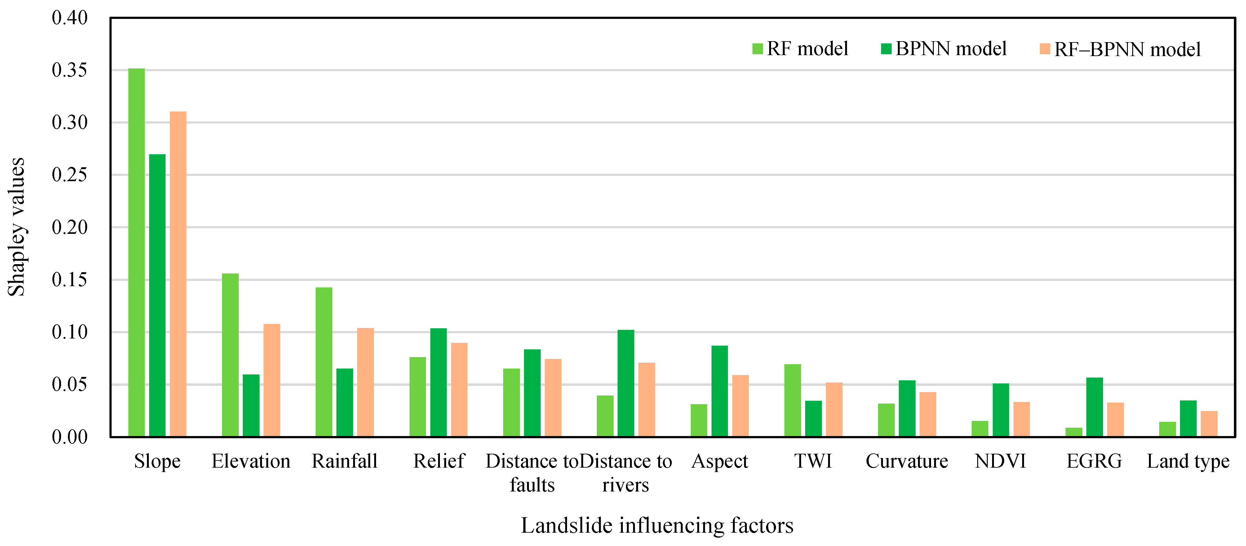
- An RF-BPNN combined model was used for susceptibility mapping, and Shapley value analysis identified slope, elevation, rainfall, and relief as the dominant factors controlling landslide susceptibility prediction.
- The KDE-PCC-based classification adjustment provides a quantitative way to incorporate observation-period deformation activity into susceptibility classification threshold optimization.
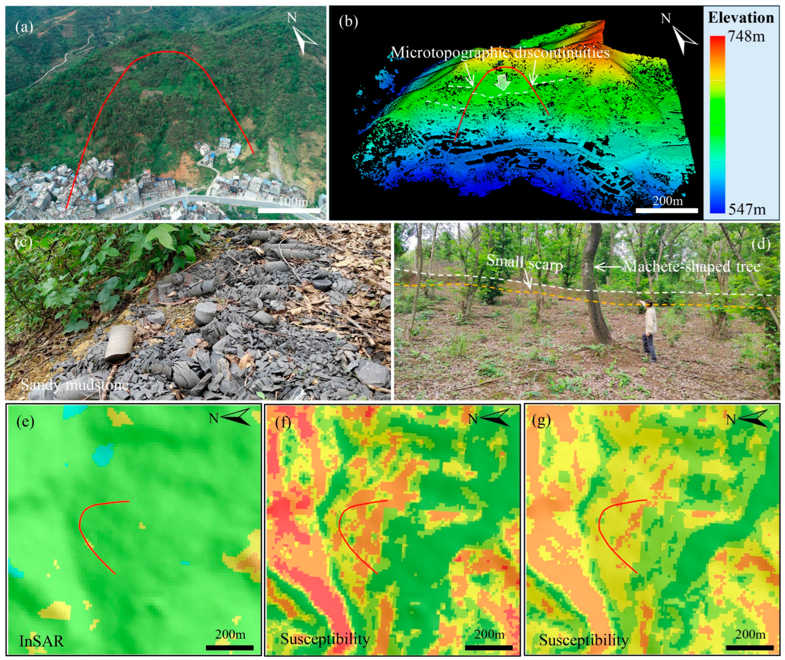
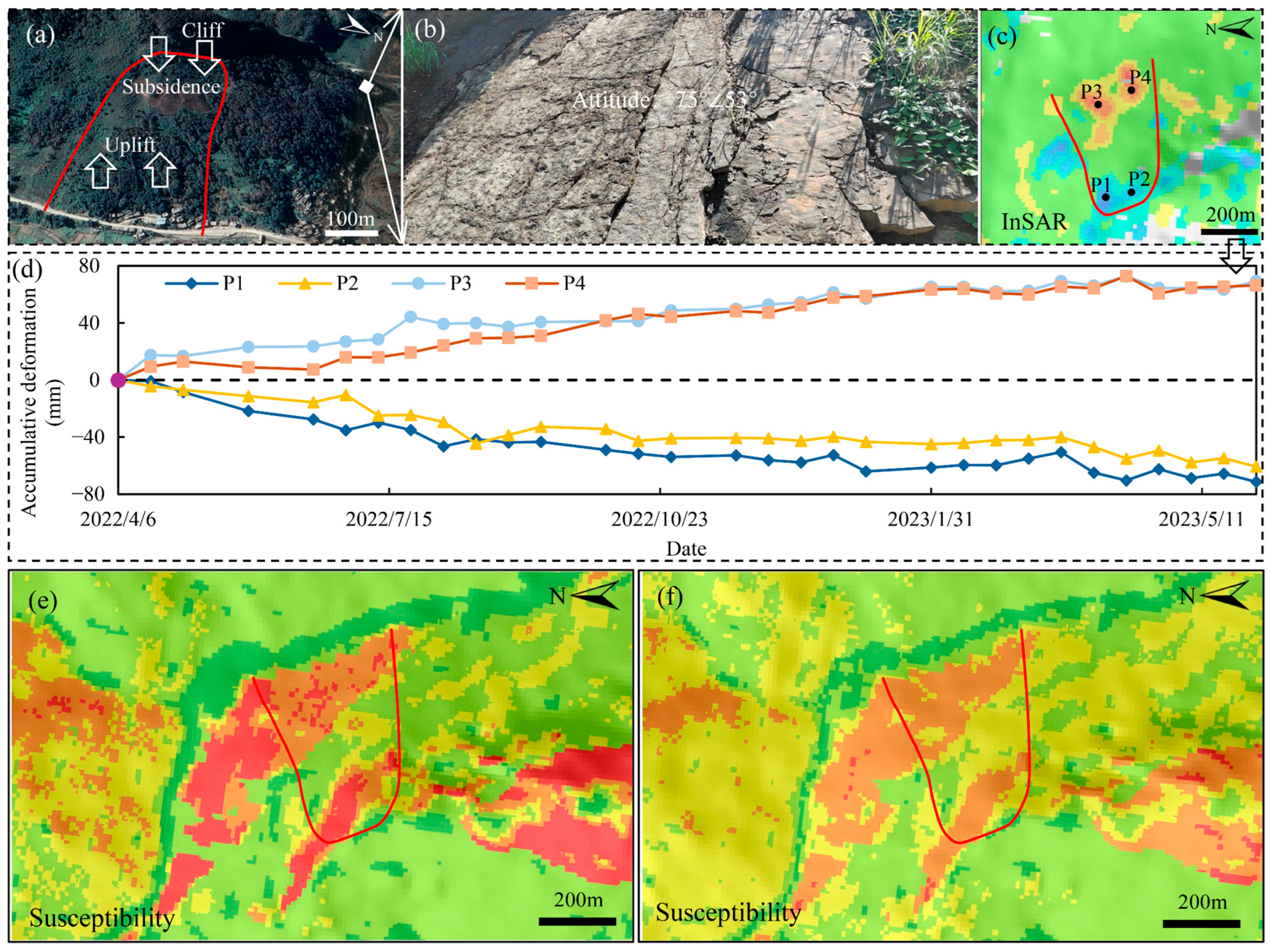
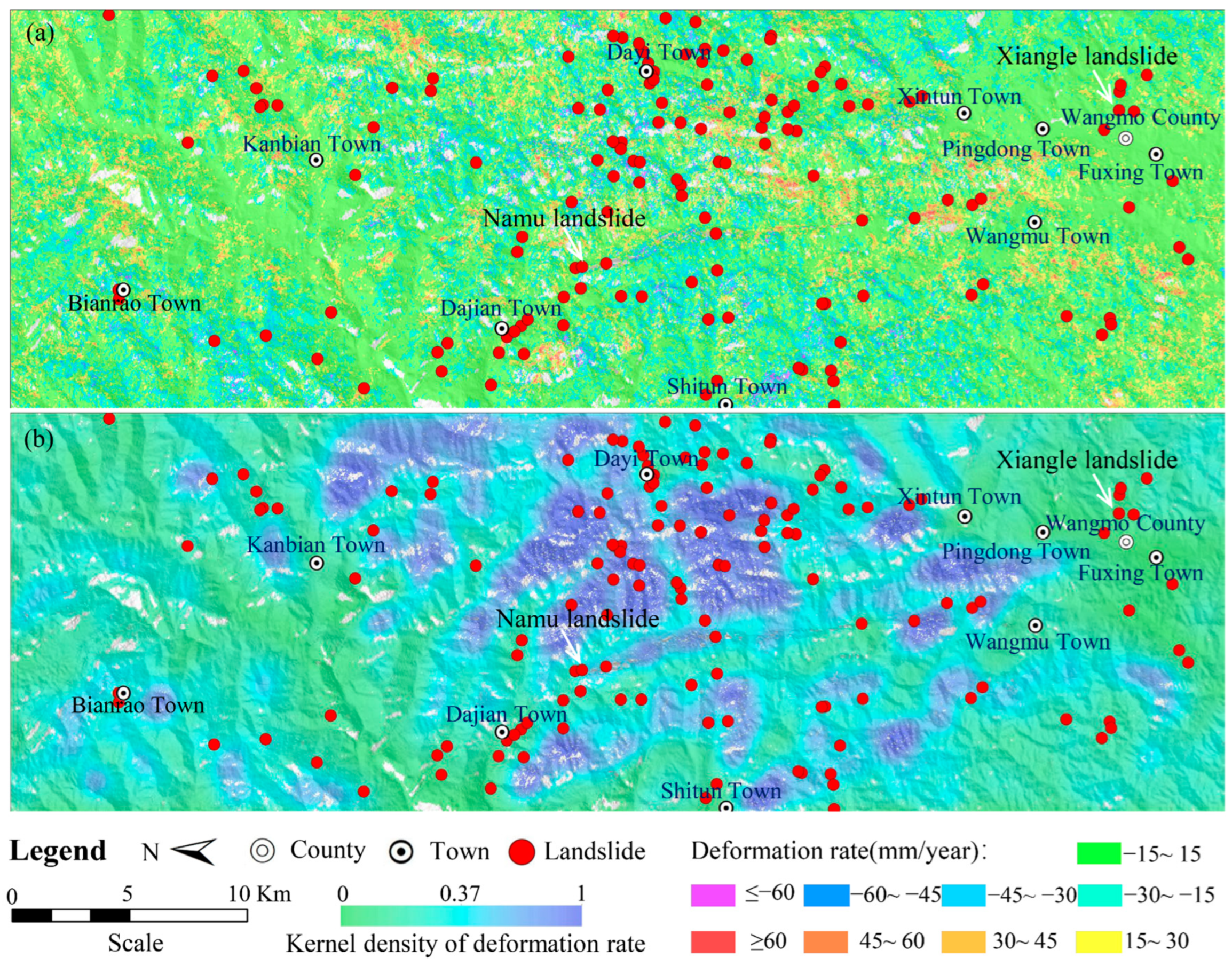
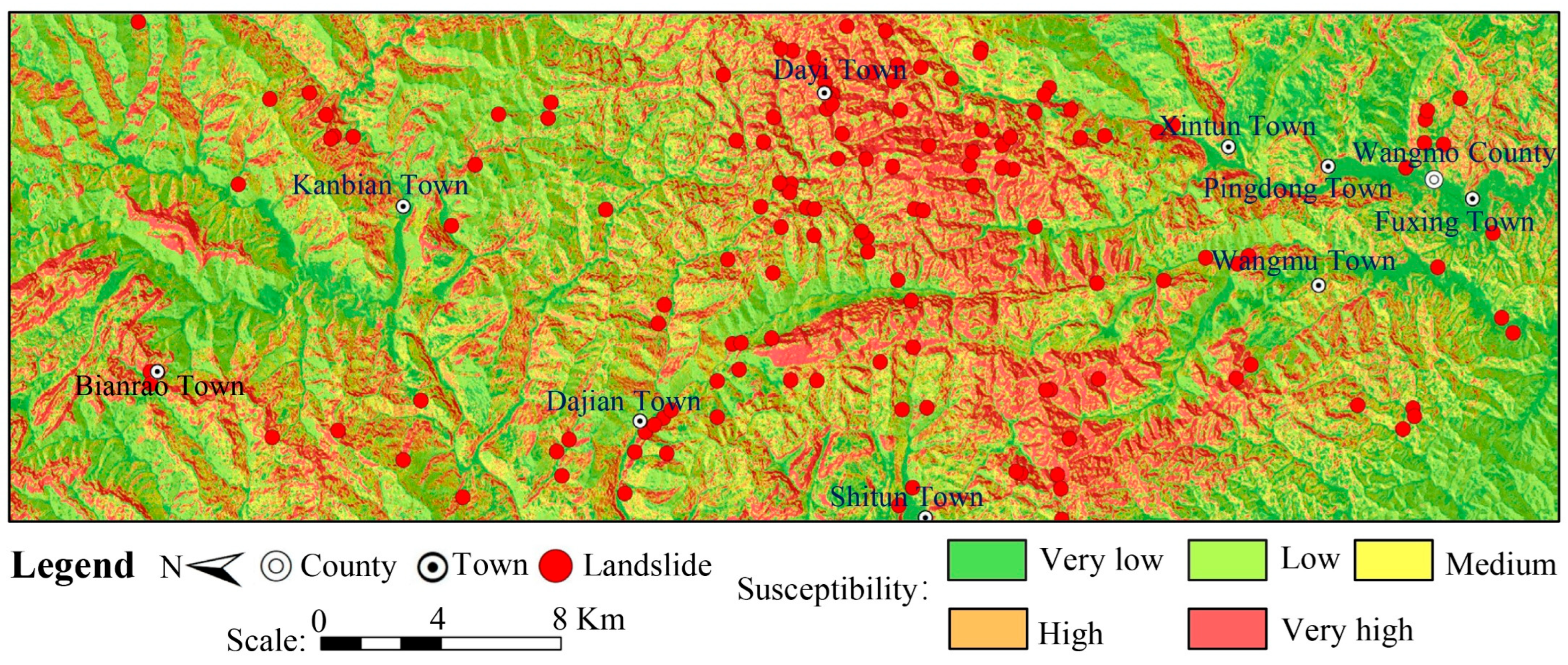
- The Xiangle and Namu landslide cases illustrate the adjustment effects of incorporating InSAR-derived deformation constraints into susceptibility classification.
Abstract
1. Introduction
2. Study Area and Data Preparation
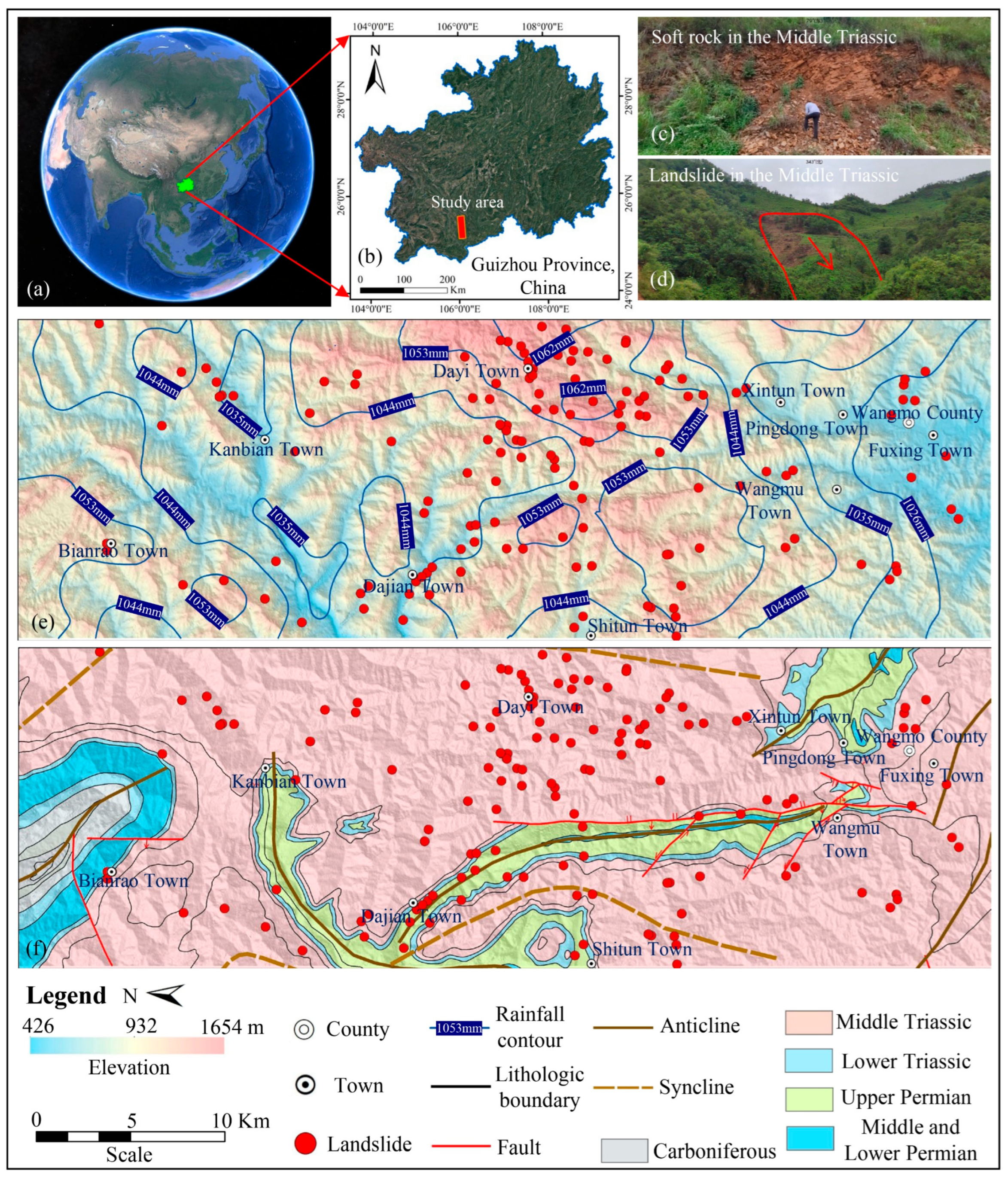
2.1. Study Area
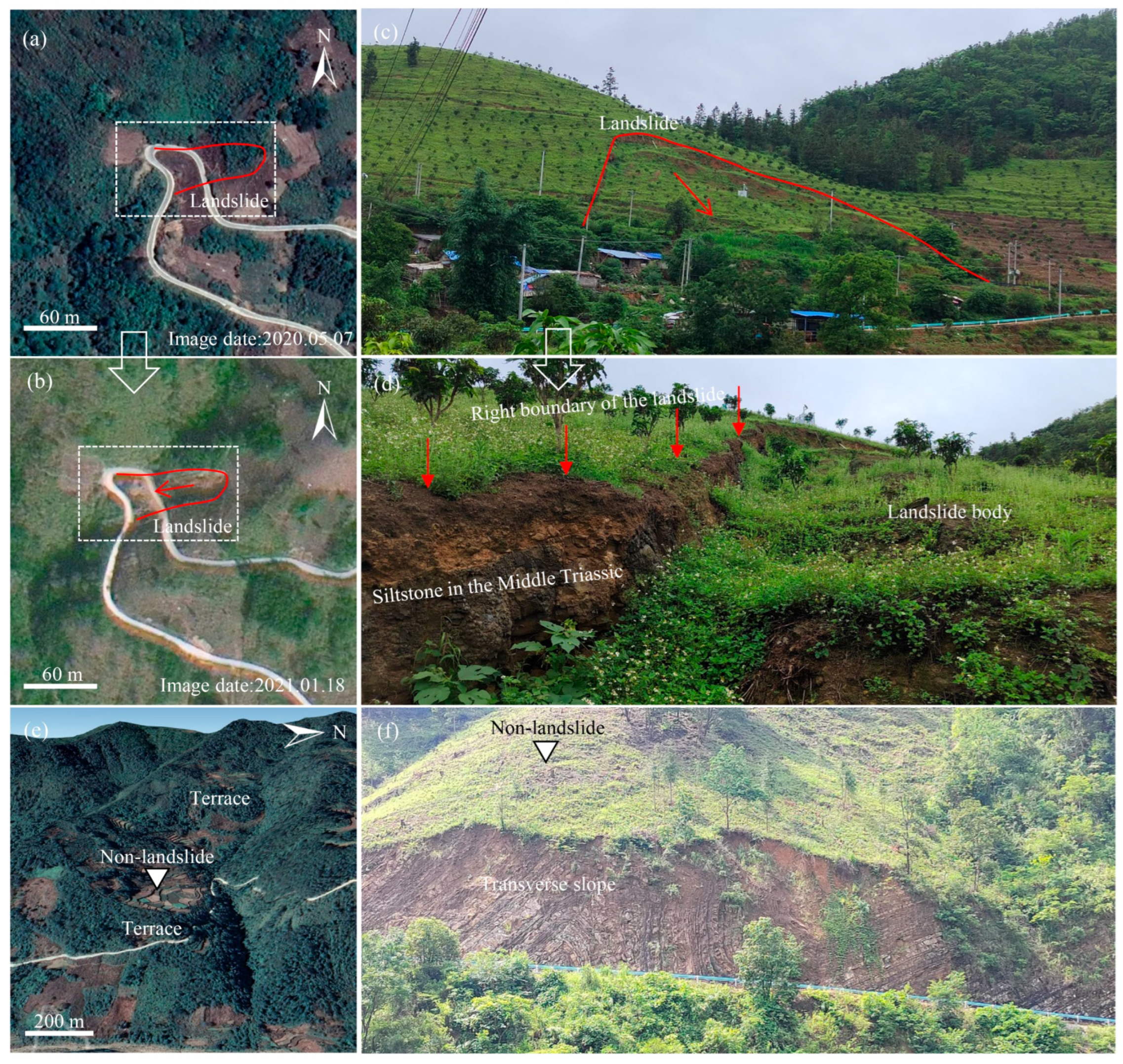
2.2. Data Preparation
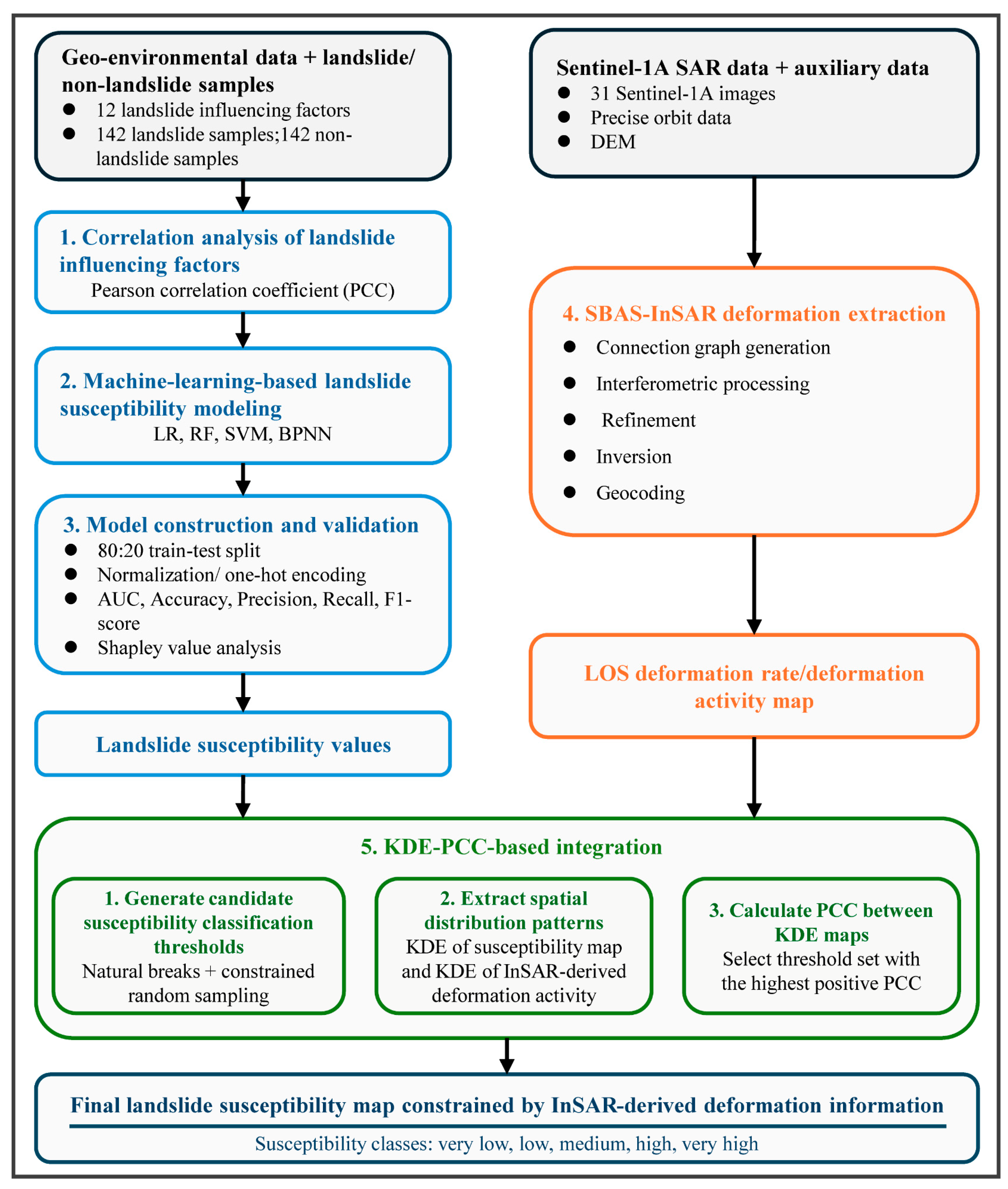
3. Improved Landslide Susceptibility Analysis Framework
3.1. Correlation Analysis of Landslide Influencing Factors
3.2. Machine Learning-Based Landslide Susceptibility Modeling
3.3. Model Construction and Validation
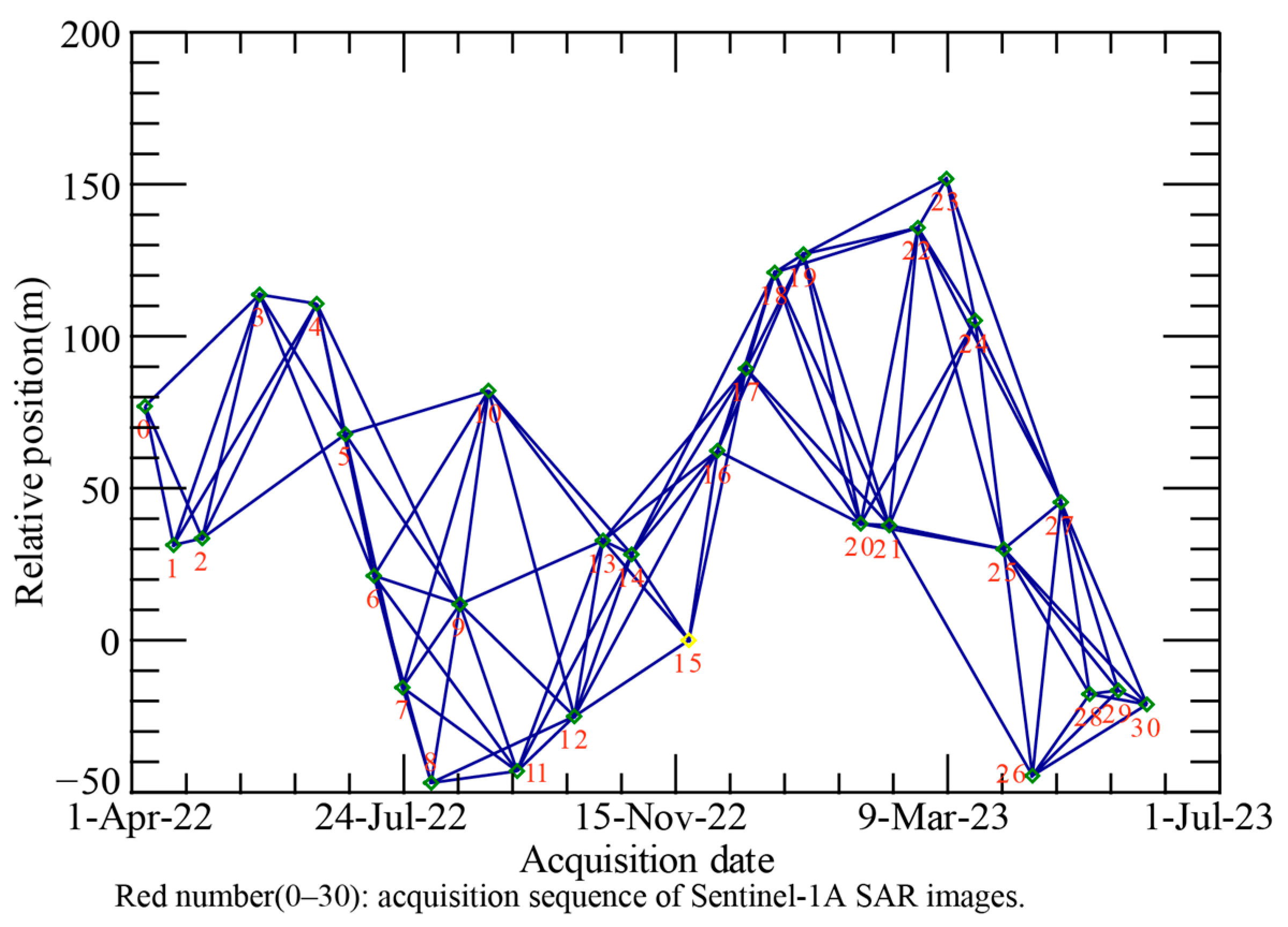
3.4. SBAS-InSAR Deformation Extraction
3.5. KDE-PCC-Based Spatial Consistency Analysis and Landslide Susceptibility Mapping
4. Results
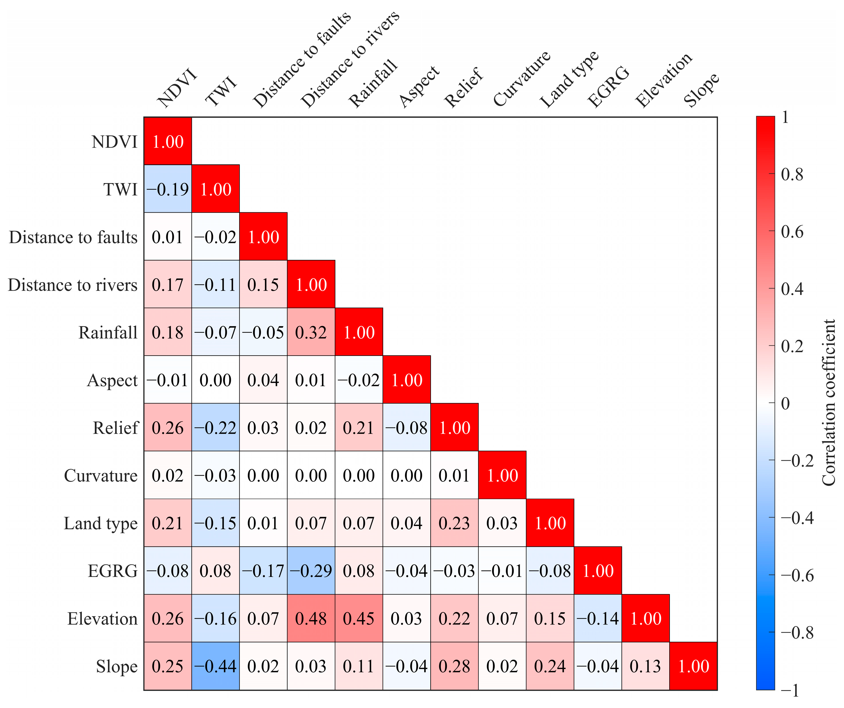
4.1. Correlation Between Landslide Influencing Factors
4.2. Optimal Selection of Machine Learning Models
4.3. InSAR-Derived Deformation in the Study Area
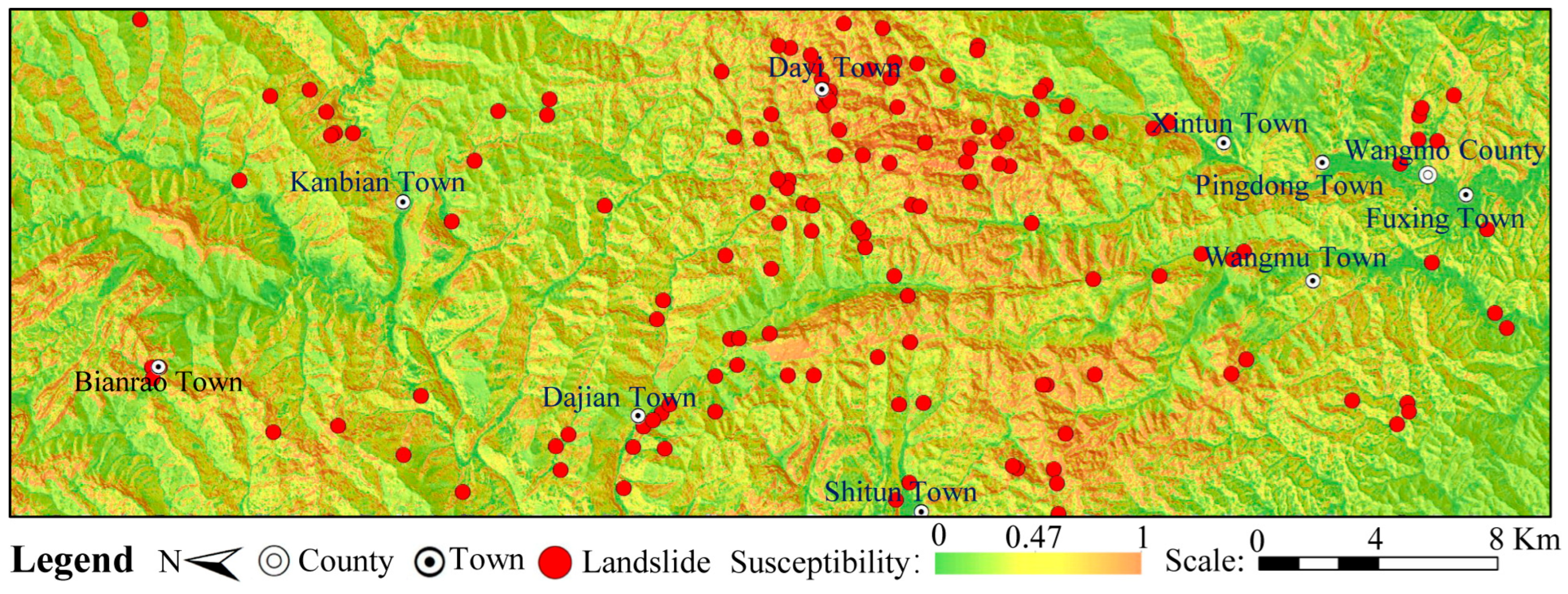
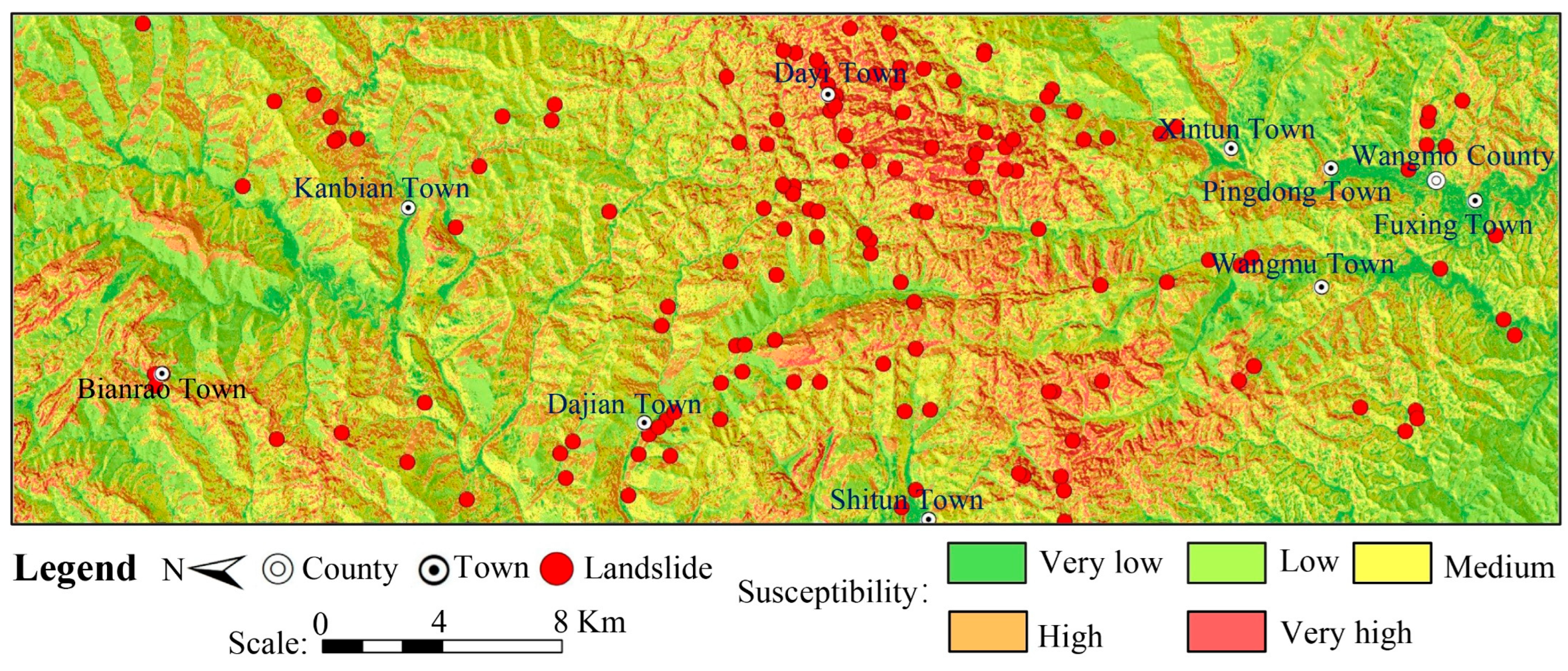
4.4. Deformation-Constrained Landslide Susceptibility Mapping
5. Discussion
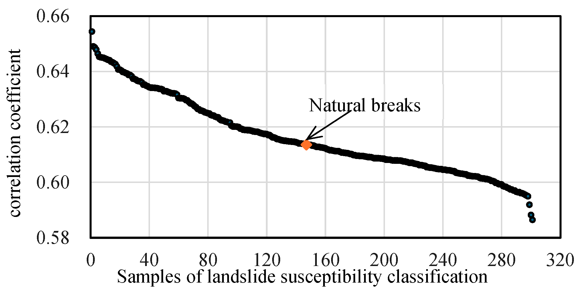
5.1. Criteria for Landslide Susceptibility Classification
5.2. Case Analysis of Deformation-Constrained LSM Classification Adjustment
5.3. Limitations of the Approach
6. Conclusions
Author Contributions
Funding
Data Availability Statement
Acknowledgments
Conflicts of Interest
References
- Yu, L.; Wang, Y.; Pradhan, B. Enhancing landslide susceptibility mapping incorporating landslide typology via stacking ensemble machine learning in Three Gorges Reservoir, China. Geosci. Front. 2024, 15, 101802. [Google Scholar] [CrossRef] [Scilit]
- Sheng, Y.; Xu, G.; Jin, B.; Zhou, C.; Li, Y.; Chen, W. Data-driven landslide spatial prediction and deformation monitoring: A case study of Shiyan city, China. Remote Sens. 2023, 15, 5256. [Google Scholar] [CrossRef] [Scilit]
- Youssef, A.M.; Pourghasemi, H.R. Landslide susceptibility mapping using machine learning algorithms and comparison of their performance at Abha Basin, Asir Region, Saudi Arabia. Geosci. Front. 2021, 12, 639–655. [Google Scholar] [CrossRef] [Scilit]
- Huang, F.; Cao, Z.; Guo, J.; Jiang, S.-H.; Li, S.; Guo, Z. Comparisons of heuristic, general statistical and machine learning models for landslide susceptibility prediction and mapping. Catena 2020, 191, 104580. [Google Scholar] [CrossRef] [Scilit]
- Lu, Y.; Xu, H.; Wang, C.; Yan, G.; Huo, Z.; Peng, Z.; Liu, B.; Xu, C. A Novel Strategy Coupling Optimised Sampling with Heterogeneous Ensemble Machine-Learning to Predict Landslide Susceptibility. Remote Sens. 2024, 16, 3663. [Google Scholar] [CrossRef] [Scilit]
- Yan, L.; Xiong, Q.; Li, D.; Cheon, E.; She, X.; Yang, S. InSAR-Driven Dynamic Landslide Hazard Mapping in Highly Vegetated Area. Remote Sens. 2024, 16, 3229. [Google Scholar] [CrossRef] [Scilit]
- Cao, C.; Zhu, K.; Xu, P.; Shan, B.; Yang, G.; Song, S. Refined landslide susceptibility analysis based on InSAR technology and UAV multi-source data. J. Clean. Prod. 2022, 368, 133146. [Google Scholar] [CrossRef] [Scilit]
- Guo, R.; Li, S.; Chen, Y.; Li, X.; Yuan, L. Identification and monitoring landslides in Longitudinal Range-Gorge Region with InSAR fusion integrated visibility analysis. Landslides 2021, 18, 551–568. [Google Scholar]
- Shahabi, H.; Hashim, M.; Bin Ahmad, B. Remote sensing and GIS-based landslide susceptibility mapping using frequency ratio, logistic regression, and fuzzy logic methods at the central Zab basin. Iran. Environ. Earth Sci. 2015, 73, 8647–8668. [Google Scholar] [CrossRef] [Scilit]
- Moresi, F.V.; Maesano, M.; di Cristofaro, M.; Scarascia Mugnozza, G.; Brunori, E. Evaluating Shallow Landslide Prediction Mapping by Using Two Different GIS-Based Models: 4SLIDE and SHALSTAB. ISPRS Int. J. Geo-Inf. 2025, 14, 144. [Google Scholar] [CrossRef] [Scilit]
- Ciurleo, M.; Ferlisi, S.; Foresta, V.; Mandaglio, M.C.; Moraci, N. Landslide Susceptibility Analysis by Applying TRIGRS to a Reliable Geotechnical Slope Model. Geosciences 2022, 12, 18. [Google Scholar]
- Lin, W.; Yin, K.L.; Wang, N.T.; Xu, Y.; Guo, Z.Z.; Li, Y.Y. Landslide hazard assessment of rainfall-induced landslide based on the CF-SINMAP model: A case study from Wuling Mountain in Hunan Province, China. Nat. Hazards 2021, 106, 679–700. [Google Scholar] [CrossRef] [Scilit]
- Ding, D.; Wu, Y.; Wu, T.; Gong, C. Landslide susceptibility assessment in Tongguan District Anhui China using information value and certainty factor models. Sci. Rep. 2025, 15, 12275. [Google Scholar] [CrossRef] [Scilit] [PubMed]
- Yang, Y.; Zhang, R.; Wang, T.; Liu, A.; He, Y.; Lv, J.; He, X.; Mao, W.; Xiang, W.; Zhang, B. An information quantity and machine learning integrated model for landslide susceptibility mapping in Jiuzhaigou, China. Nat. Hazards 2024, 120, 10185–10217. [Google Scholar] [CrossRef] [Scilit]
- Youssef, B.; Bouskri, I.; Brahim, B.; Kader, S.; Brahim, I.; Abdelkrim, B.; Spalevic, V. The contribution of the frequency ratio model and the prediction rate for the analysis of landslide risk in the Tizi N’tichka area on the national road (RN9) linking Marrakech and Ouarzazate. Catena 2023, 232, 107464. [Google Scholar] [CrossRef] [Scilit]
- Liu, S.; Jiang, X.; He, X.; Qiu, H.; Yang, Y.; Zhao, R.; Hu, H. A novel landslide susceptibility mapping method based on a backpropagation neural network algorithm with optimized non-landslide samples and hyperparameters. Eng. Appl. Artif. Intell. 2025, 155, 111052. [Google Scholar] [CrossRef] [Scilit]
- Sun, D.; Xu, J.; Wen, H.; Wang, D. Assessment of landslide susceptibility mapping based on Bayesian hyperparameter optimization: A comparison between logistic regression and random forest. Eng. Geol. 2021, 281, 105972. [Google Scholar] [CrossRef] [Scilit]
- Xie, Z.; Chen, G.; Meng, X.; Zhang, Y.; Qiao, L.; Tan, L. A comparative study of landslide susceptibility mapping using weight of evidence, logistic regression and support vector machine and evaluated by SBAS-InSAR monitoring: Zhouqu to Wudu segment in Bailong River Basin, China. Environ. Earth Sci. 2017, 76, 313. [Google Scholar] [CrossRef] [Scilit]
- Dou, H.; He, J.; Huang, S.; Jian, W.; Guo, C. Influences of non-landslide sample selection strategies on landslide susceptibility mapping by machine learning. Geomat. Nat. Hazards Risk 2023, 14, 2285719. [Google Scholar] [CrossRef] [Scilit]
- Lundberg, S.M.; Lee, S.I. A unified approach to interpreting model predictions. In Proceedings of the 31st International Conference on Neural Information Processing Systems, Long Beach, CA, USA, 4–9 December 2017; pp. 4768–4777. [Google Scholar]
- Yang, Z.; Jiang, X.; Zheng, M.; Guo, Q. Effects of SBAS-InSAR Deformation Integration Methods and Machine Learning Model Selection on Landslide Susceptibility Mapping. IEEE Access 2025, 13, 98622–98638. [Google Scholar] [CrossRef] [Scilit]
- Wu, X.; Qi, X.; Peng, B.; Wang, J. Optimized Landslide Susceptibility Mapping and Modelling Using the SBAS-InSAR Coupling Model. Remote Sens. 2024, 16, 2873. [Google Scholar] [CrossRef] [Scilit]
- Xu, S.; Song, Y.; Lu, P.; Mu, G.; Yang, K.; Wang, S. An optimized non-landslide sampling method for Landslide susceptibility evaluation using machine learning models. Nat. Hazards 2025, 121, 5873–5900. [Google Scholar] [CrossRef] [Scilit]
- Wang, J.; Wang, Y.; Li, M.; Qi, Z.; Li, C.; Qi, H.; Zhang, X. Improved landslide susceptibility assessment: A new negative sample collection strategy and a comparative analysis of zoning methods. Ecol. Indic. 2024, 169, 112948. [Google Scholar] [CrossRef] [Scilit]
- Fu, Z.; Wang, F.; Dou, J.; Nam, K.; Ma, H. Enhanced absence sampling technique for data-driven landslide susceptibility mapping: A case study in Songyang County, China. Remote Sens. 2023, 15, 3345. [Google Scholar] [CrossRef] [Scilit]
- Ye, C.M.; Tang, R.; Wei, R.L.; Guo, Z.X.; Zhang, H.J. Generating accurate negative samples for landslide susceptibility mapping: A combined self-organizing-map and one-class SVM method. Front. Earth Sci. 2023, 10, 1054027. [Google Scholar] [CrossRef] [Scilit]
- Xi, C.J.; Han, M.; Hu, X.W.; Liu, B.; He, K.; Luo, G.; Cao, X.C. Effectiveness of Newmark-based sampling strategy for coseismic landslide susceptibility mapping using deep learning, support vector machine, and logistic regression. Bull. Eng. Geol. Environ. 2022, 81, 174. [Google Scholar] [CrossRef] [Scilit]
- Pradhan, B.; Dikshit, A.; Lee, S.; Kim, H. An explainable AI (XAI) model for landslide susceptibility modeling. Appl. Soft Comput. 2023, 142, 110324. [Google Scholar] [CrossRef] [Scilit]
- Wang, N.; Zhang, H.; Dahal, A.; Cheng, W.; Zhao, M.; Lombardo, L. On the use of explainable AI for susceptibility modeling: Examining the spatial pattern of SHAP values. Geosci. Front. 2024, 15, 101800. [Google Scholar] [CrossRef] [Scilit]
- Li, Y.; Feng, X.; Li, Y.; Jiang, W.; Yu, W. Detection and Analysis of Potential Landslides Based on SBAS-InSAR Technology in Alpine Canyon Region. Environ. Sci. Pollut. Res. 2024, 31, 6492–6510. [Google Scholar]
- Yazici, B.V.; Tunc Gormus, E. Investigating Persistent Scatterer InSAR (PSInSAR) Technique Efficiency for Landslides Mapping: A Case Study in Artvin Dam Area, in Turkey. Geocarto Int. 2022, 37, 2293–2311. [Google Scholar]
- Zhou, C.; Cao, Y.; Gan, L.; Wang, Y.; Motagh, M.; Roessner, S.; Hu, X.; Yin, K. A Novel Framework for Landslide Displacement Prediction Using MT-InSAR and Machine Learning Techniques. Eng. Geol. 2024, 334, 107497. [Google Scholar] [CrossRef] [Scilit]
- van Natijne, A.L.; Bogaard, T.A.; van Leijen, F.J.; Hanssen, R.F.; Lindenbergh, R.C. World-Wide InSAR Sensitivity Index for Landslide Deformation Tracking. Int. J. Appl. Earth Obs. Geoinf. 2022, 111, 102829. [Google Scholar] [CrossRef] [Scilit]
- Zhou, C.; Cao, Y.; Hu, X.; Yin, K.; Wang, Y.; Catani, F. Enhanced Dynamic Landslide Hazard Mapping Using MT-InSAR Method in the Three Gorges Reservoir Area. Landslides 2022, 19, 1585–1597. [Google Scholar] [CrossRef] [Scilit]
- Devara, M.; Tiwari, A.; Dwivedi, R. Landslide susceptibility mapping using MT-InSAR and AHP enabled GIS-based multi-criteria decision analysis. Geomat. Nat. Hazards Risk 2021, 12, 675–693. [Google Scholar] [CrossRef] [Scilit]
- Kulsoom, I.; Hua, W.; Hussain, S.; Chen, Q.; Khan, G.; Shihao, D. SBAS-InSAR based validated landslide susceptibility mapping along the Karakoram Highway: A case study of Gilgit-Baltistan, Pakistan. Sci. Rep. 2023, 13, 3344. [Google Scholar] [CrossRef] [Scilit] [PubMed]
- Cheng, Y.; Pang, H.; Li, Y.; Fan, L.; Wei, S.; Yuan, Z.; Fang, Y. Applications and Advancements of Spaceborne InSAR in Landslide Monitoring and Susceptibility Mapping: A Systematic Review. Remote Sens. 2025, 17, 999. [Google Scholar] [CrossRef] [Scilit]
- Zhao, D.; Han, J.; Liu, X.; Zuo, Z.; Zheng, K. Exploration of the Application of Fine Reconstruction of Unmanned Aerial Vehicles in Landslide Disaster Investigation and Management. In Hydropower and Renewable Energies (IHDC 2024); Springer Nature: Singapore, 2025; Volume 487, pp. 489–502. [Google Scholar] [CrossRef] [Scilit]
- Berardino, P.; Fornaro, G.; Lanari, R.; Sansosti, E. A new algorithm for surface deformation monitoring based on small baseline differential SAR interferograms. IEEE Trans. Geosci. Remote Sens. 2002, 40, 2375–2383. [Google Scholar] [CrossRef] [Scilit]
- Chen, G.; Zhang, Y.; Zeng, R.; Yang, Z.; Chen, X.; Zhao, F.; Meng, X. Detection of land subsidence associated with land creation and Rapid urbanization in the Chinese loess plateau using time series InSAR: A case study of Lanzhou new District. Remote Sens. 2018, 10, 270. [Google Scholar] [CrossRef] [Scilit]
- Wang, H.; Jiang, Z.; Xu, W.; Wang, R.; Xie, W. Physical model test on deformation and failure mechanism of deposit landslide under gradient rainfall. Bull. Eng. Geol. Environ. 2022, 81, 02913. [Google Scholar] [CrossRef] [Scilit]
- Pourghasemi, H.R.; Gayen, A.; Edalat, M.; Zarafshar, M.; Tiefenbacher, J.P. Is multi-hazard mapping effective in assessing natural hazards and integrated watershed management? Geosci. Front. 2020, 11, 1203–1217. [Google Scholar] [CrossRef] [Scilit]
- Chen, W.; Zhang, S.; Li, R.; Shahabi, H. Performance evaluation of the GIS-based data mining techniques of best-first decision tree, random forest, and naive Bayes tree for landslide susceptibility modeling. Sci. Total Environ. 2018, 644, 1006–1018. [Google Scholar] [CrossRef] [Scilit] [PubMed]
- Hussain, M.A.; Chen, Z.; Zhou, Y.; Meena, S.R.; Ali, N.; Shah, S.U. Landslide susceptibility mapping using artificial intelligence models: A case study in the Himalayas. Landslides 2025, 22, 2089–2103. [Google Scholar] [CrossRef] [Scilit]
- Shang, H.; Su, L.; Chen, W.; Tsangaratos, P.; Ilia, I.; Liu, S.; Cui, S.; Duan, Z. Spatial Prediction of Landslide Susceptibility Using Logistic Regression (LR), Functional Trees (FTs), and Random Subspace Functional Trees (RSFTs) for Pengyang County, China. Remote Sens. 2023, 15, 4952. [Google Scholar] [CrossRef] [Scilit]
- Sujatha, E.R.; Sridhar, V. Landslide Susceptibility Analysis: A Logistic Regression Model Case Study in Coonoor, India. Hydrology 2021, 8, 41. [Google Scholar] [CrossRef] [Scilit]
- Zhang, W.; He, Y.; Wang, L.; Liu, S.; Meng, X. Landslide Susceptibility mapping using random forest and extreme gradient boosting: A case study of Fengjie, Chongqing. Geol. J. 2023, 58, 2372–2387. [Google Scholar] [CrossRef] [Scilit]
- Sun, D.; Shi, S.; Wen, H.; Xu, J.; Zhou, X.; Wu, J. A hybrid optimization method of factor screening predicated on GeoDetector and Random Forest for Landslide Susceptibility Mapping. Geomorphology 2021, 379, 107623. [Google Scholar] [CrossRef] [Scilit]
- He, Q.; Wu, S.; Zhao, X.; Hui, Z.; Wang, Z.; Tsangaratos, P.; Ilia, I.; Chen, W.; Chen, Y.; Hao, Y. Evaluation of landslide susceptibility of mountain highway based on RF and SVM models. Sci. Rep. 2025, 15, 24991. [Google Scholar] [CrossRef] [Scilit] [PubMed]
- Zhao, S.; Zhao, Z. A Comparative Study of Landslide Susceptibility Mapping Using SVM and PSO-SVM Models Based on Grid and Slope Units. Math. Probl. Eng. 2021, 2021, 8854606. [Google Scholar] [CrossRef] [Scilit]
- Xue, Z.; Feng, W.; Li, B.; Zhou, Y.; Yi, X.; Wu, M. Landslide susceptibility mapping based on the coupling of two correlation methods and the BP neural network model: A case study of the Baihetan Reservoir area, China. Front. Environ. Sci. 2022, 10, 1039985. [Google Scholar] [CrossRef] [Scilit]
- Chen, J.; Guo, Q.; Yang, J.; Luo, J.; Wang, L. Seismic landslide susceptibility assessment based on game theory combination weighting and information volume model: A case study of Luding earthquake high-intensity area. Sādhanā 2025, 50, 6. [Google Scholar] [CrossRef] [Scilit]
- He, Y.; Bin, Z.; Xu, X.; Yu, H.; Zhang, Y.; Li, N.; Li, M. Landslide Risk Assessment Along Railway Lines Using Multi-Source Data: A Game Theory-Based Integrated Weighting Approach for Sustainable Infrastructure Planning. Sustainability 2025, 17, 5522. [Google Scholar] [CrossRef] [Scilit]
- Zhang, Z.; Sun, J. Regional Landslide Susceptibility Assessment and Model Adaptability Research. Remote Sens. 2024, 16, 2305. [Google Scholar] [CrossRef] [Scilit]
- Sun, X.H.; Chen, J.P.; Han, X.D.; Bao, Y.D.; Zhan, J.W.; Peng, W. Application of a GIS-based slope unit method for landslide susceptibility mapping along the rapidly uplifting section of the upper Jinsha River, South-Western China. Bull. Eng. Geol. Environ. 2020, 79, 533–549. [Google Scholar] [CrossRef] [Scilit]
- Hanley, J.A.; McNeil, B.J. A Method of Comparing the Areas under Receiver Operating Characteristic Curves Derived from the Same Cases. Radiology 1983, 148, 839–843. [Google Scholar] [CrossRef] [Scilit] [PubMed]
- Xu, Q.; Guo, C.; Dong, X.; Li, W.; Lu, H.; Fu, H.; Liu, X. Mapping and characterizing displacements of landslides with InSAR and airborne LiDAR Technologies: A case study of Danba county, southwest China. Remote Sens. 2021, 13, 4234. [Google Scholar] [CrossRef] [Scilit]
- Zhang, L.; Dai, K.; Deng, J.; Ge, D.; Liang, R.; Li, W.; Xu, Q. Identifying potential landslides by stacking-InSAR in southwestern China and its performance comparison with SBAS-InSAR. Remote Sens. 2021, 13, 3662. [Google Scholar] [CrossRef] [Scilit]
- Li, Y.; Lei, Y.; Chen, B.; Chen, J. Evaluation of geological hazard susceptibility based on the multi-kernel density information method. Sci. Rep. 2025, 15, 7892. [Google Scholar] [CrossRef] [Scilit] [PubMed]
- Jin, J.; Chen, G.; Meng, X.; Zhang, Y.; Shi, W.; Li, Y.; Yang, Y.; Jiang, W. Prediction of River Damming Susceptibility by Landslides Based on a Logistic Regression Model and InSAR Techniques: A Case Study of the Bailong River Basin, China. Eng. Geol. 2022, 299, 106562. [Google Scholar] [CrossRef] [Scilit]
- Liu, Y.; Xu, P.; Cao, C.; Shan, B.; Zhu, K.; Ma, Q.; Zhang, Z.; Yin, H. A comparative evaluation of machine learning algorithms and an improved optimal model for landslide susceptibility: A case study. Geomat. Nat. Hazards Risk 2021, 12, 1973–2001. [Google Scholar] [CrossRef] [Scilit]










| Groups | Factors | Descriptions | Data Sources |
|---|---|---|---|
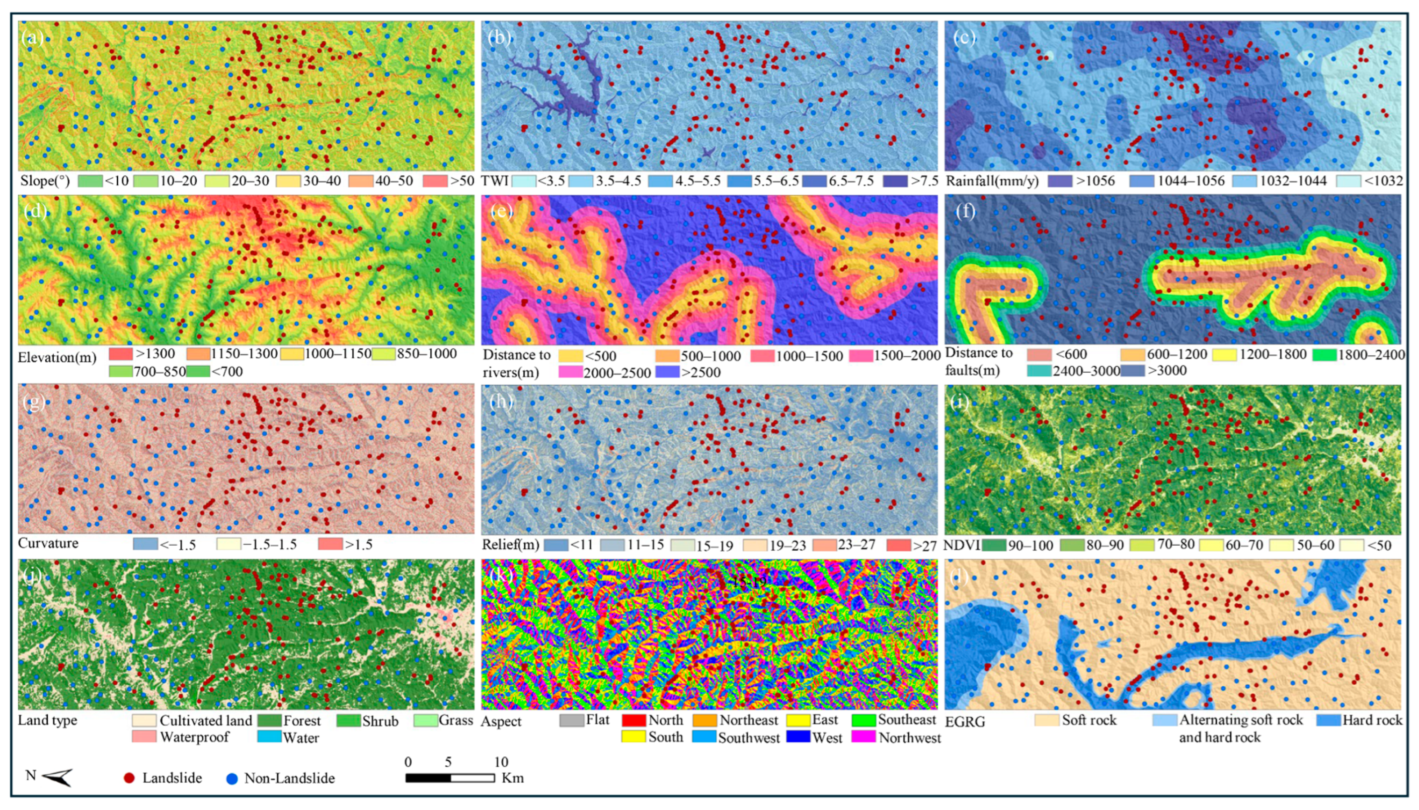
| Topography | Elevation | ALOS PALSAR DEM (12.5 m pixel spacing, upsampled from SRTM 30 m) | https://search.asf.alaska.edu/ (accessed on 12 March 2024) |
| Slope | Obtained using ALOS PALSAR DEM | Extracted from the DEM | |
| Aspect | |||
| Curvature | |||
| Relief | |||
| Geology | EGRG | Vector data | https://geocloud.cgs.gov.cn/ (accessed on 12 March 2024) |
| Distance to faults | |||
| Meteorology and hydrology | Distance to rivers | Vector data | http://www.openstreetmap.org/ (accessed on 12 March 2024) |
| Rainfall | 1-km monthly precipitation dataset for China (1901–2023) | https://data.tpdc.ac.cn/ (accessed on 12 March 2024) | |
| TWI | Obtained using ALOS PALSAR DEM | Extracted from the DEM | |
| Geographic environment | Land types | Land use dataset in China | https://livingatlas.arcgis.com/landcover/ (accessed on 12 March 2024) |
| NDVI | Landsat 8 OLI_TIRS, 30 m resolution | https://www.gscloud.cn/ (accessed on 12 March 2024) |
| Model | AUC | Accuracy | Precision | Recall | F1-Score |
|---|---|---|---|---|---|
| LR | 0.84 | 0.73 | 0.74 | 0.71 | 0.73 |
| RF | 0.93 | 0.88 | 0.84 | 0.93 | 0.88 |
| SVM | 0.83 | 0.77 | 0.78 | 0.75 | 0.76 |
| BPNN | 0.91 | 0.84 | 0.88 | 0.79 | 0.83 |
Disclaimer/Publisher’s Note: The statements, opinions and data contained in all publications are solely those of the individual author(s) and contributor(s) and not of MDPI and/or the editor(s). MDPI and/or the editor(s) disclaim responsibility for any injury to people or property resulting from any ideas, methods, instructions or products referred to in the content. |
© 2026 by the authors. Licensee MDPI, Basel, Switzerland. This article is an open access article distributed under the terms and conditions of the Creative Commons Attribution (CC BY) license.
Share and Cite
Han, X.; Song, W.; Pan, S.; Cao, C.; Bao, Y. Landslide Susceptibility Mapping Constrained by InSAR-Derived Deformation Using Multi-Source Data Integration. Remote Sens. 2026, 18, 2540. https://doi.org/10.3390/rs18152540
Han X, Song W, Pan S, Cao C, Bao Y. Landslide Susceptibility Mapping Constrained by InSAR-Derived Deformation Using Multi-Source Data Integration. Remote Sensing. 2026; 18(15):2540. https://doi.org/10.3390/rs18152540
Chicago/Turabian StyleHan, Xudong, Wei Song, Shuhua Pan, Chen Cao, and Yiding Bao. 2026. "Landslide Susceptibility Mapping Constrained by InSAR-Derived Deformation Using Multi-Source Data Integration" Remote Sensing 18, no. 15: 2540. https://doi.org/10.3390/rs18152540
APA StyleHan, X., Song, W., Pan, S., Cao, C., & Bao, Y. (2026). Landslide Susceptibility Mapping Constrained by InSAR-Derived Deformation Using Multi-Source Data Integration. Remote Sensing, 18(15), 2540. https://doi.org/10.3390/rs18152540