Urban Development Detection Along the Transportation Corridors of the Mongolian Plateau Supported by SDGSAT-1 NTL Data



Highlights
- A method for characterizing urban development supported by multi-source remote sensing data, including nighttime light data with higher resolution.
- The City Development Index (CDI) indices of 11 cities were obtained, revealing the geographical differences of urban development on the Mongolian Plateau.
- The CDI was established to be used in urban development detection in grassland areas.
- Both SDGSAT-1 NTL data and socioeconomic data were used for urban development detection.
Abstract
1. Introduction
2. Materials and Methods
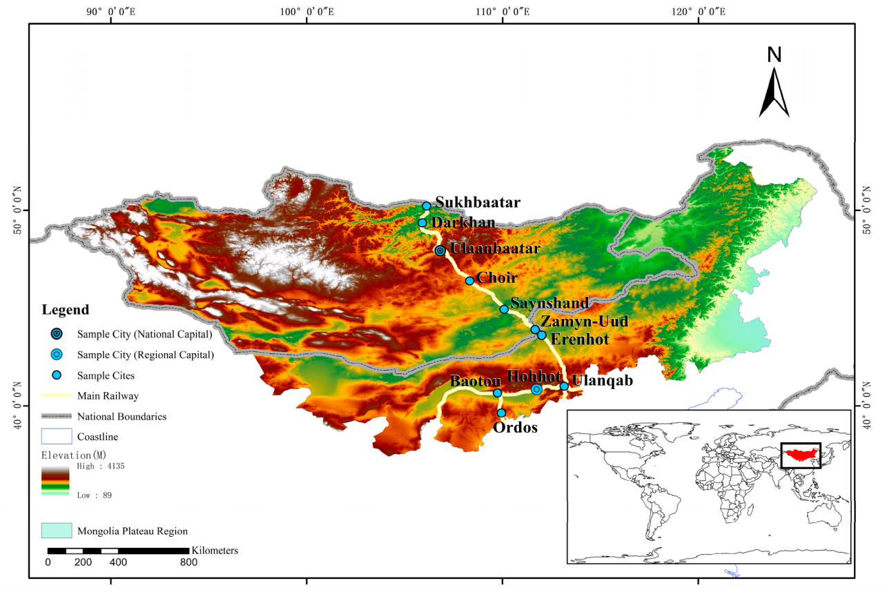
2.1. Study Area
2.2. Data
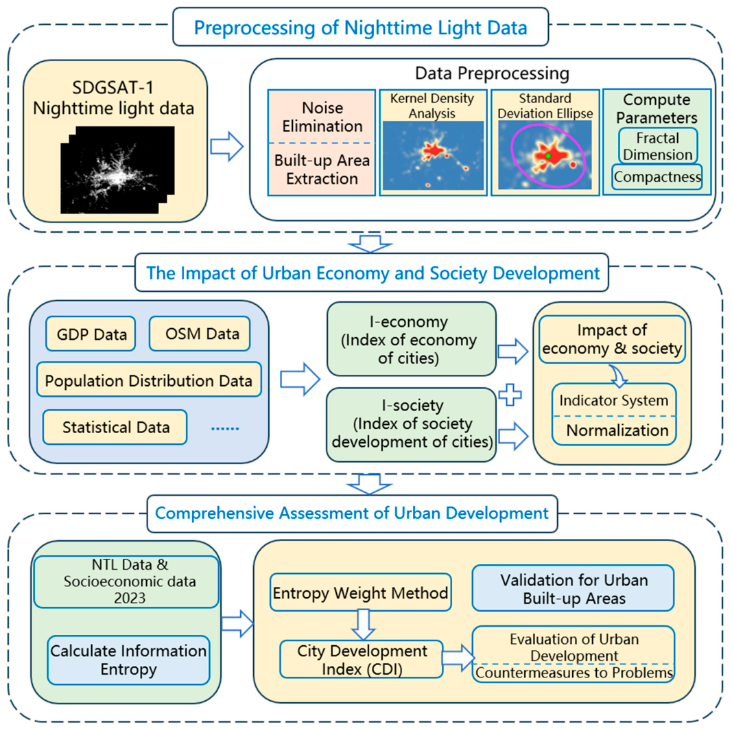
2.3. Technical Roadmap
2.4. Isolating Urban Built-Up Areas Using Nighttime Light Data
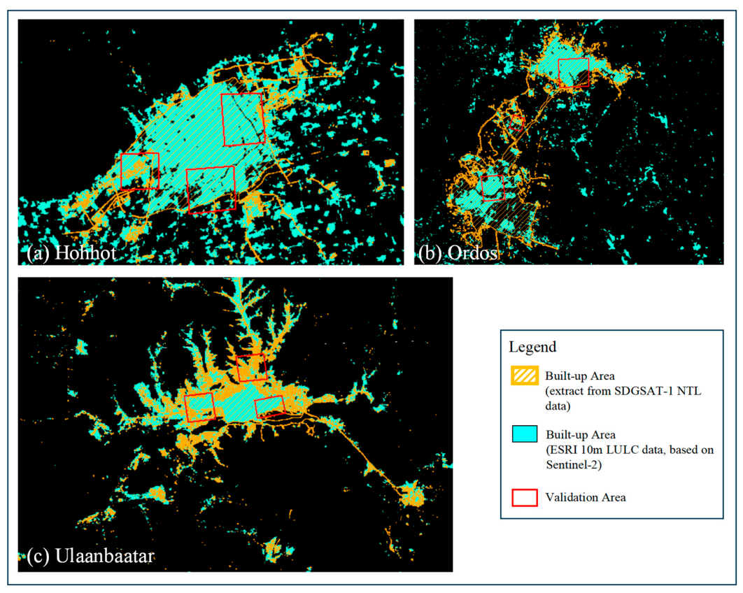
2.5. Validation for Urban Built-Up Areas
2.6. CDI and Weighting Method Based on Information Entropy
3. Results
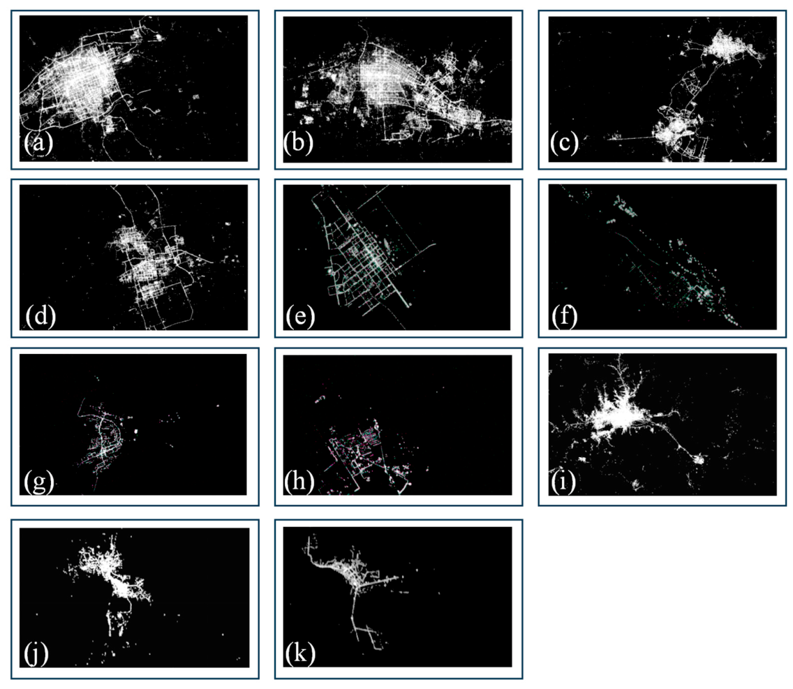
3.1. Urban Spatial Distribution in Nighttime Light Images
3.2. Results of I-Economy and I-Society
3.3. Validation for Urban Built-Up Areas and Analysis of Urban Morphology
3.4. Results of City Development Index
4. Discussion
4.1. Adaptability, Method Comparison and Accuracy Validation
4.2. Anthropogenic and Natural Driving Factors of Urban Development
4.3. Limitation and Future Work
5. Conclusions
Author Contributions
Funding
Data Availability Statement
Acknowledgments
Conflicts of Interest
References
- U.N. General Assembly (UNGA). Transforming our world: The 2030 agenda for sustainable development. In Resolut; A/RES/70/1; UN General Assembly: New York, NY, USA, 2015; Volume 251, p. 35. [Google Scholar]
- United Nations, Department of Economic and Social Affairs, Population Division. World Population Prospects: The 2017 Revision, Key Findings and Advance Tables; Working Paper No. ESA/P/WP/248; United Nations: New York, NY, USA, 2017. [Google Scholar]
- Defries, R.S.; Bounoua, L.; Collatz, G.J. Human modification of the landscape and surface climate in the next fifty years. Glob. Change Biol. 2002, 8, 438–458. [Google Scholar] [CrossRef]
- Gao, Y.; Wang, H.; Wang, P.T.; Sun, X.Y.; Lv, T.T. Population Spatial Processing for Chinese Coastal Zones Based on Census and Multiple Night Light Data. Resour. Sci. 2013, 35, 2517–2523. [Google Scholar]
- Liu, B.; Chen, Z.; Yu, B.; Yang, C.S.; Qiu, B.W.; Tu, Y. Kinetic energy assessment and similarity analysis of urban development based on NPP-VIIRS nighttime light remote sensing. Natl. Remote Sens. Bull. 2021, 25, 1187–1200. [Google Scholar] [CrossRef]
- Shimei, W.E.I.; Jinghu, P.A.N. Identification of Urban Spatial Structure in Zhengzhou City based on Nighttime Light and Microblog Check-in Data. Remote Sens. Technol. Appl. 2022, 37, 771–780. [Google Scholar]
- Pingbin, J.I.N.; Pengfei, X.U. A study of urbanization progress and spatial pattern using DMSP/OLS nighttime light data: A case study of Hangzhou City. Remote Sens. Land Resour. 2017, 29, 205–213. [Google Scholar]
- Zhang, W.; Zhang, Z.; Zhoum, Y. Temporal-spatial Evolution Characteristics of Lanxi Urban Agglomeration Based on Night Light Data. Remote Sens. Inf. 2020, 35, 38–43. [Google Scholar]
- Ch, R.; Martin, D.A.; Vargas, J.F. Measuring the size and growth of cities using nighttime light. J. Urban Econ. 2021, 125, 103254. [Google Scholar] [CrossRef]
- Zhang, Q.; He, C.; Liu, Z. Studying urban development and change in the contiguous United States using two scaled measures derived from nighttime lights data and population census. GIScience Remote Sens. 2014, 51, 63–82. [Google Scholar] [CrossRef]
- Tselios, V.; Stathakis, D. Exploring regional and urban clusters and patterns in Europe using satellite observed lighting. Environ. Plan. B Urban Anal. City Sci. 2020, 47, 553–568. [Google Scholar]
- Gilbert, K.M.; Shi, Y. Nighttime Lights and Urban Expansion: Illuminating the Correlation between Built-Up Areas of Lagos City and Changes in Climate Parameters. Buildings 2023, 13, 2999. [Google Scholar] [CrossRef]
- Huadong, G.U.O.; Chen, H.; Chen, L.; Fu, B. Progress on CAS Earth Satellite Development. Chin. J. Space Sci. 2020, 40, 707–717. [Google Scholar] [CrossRef]
- Liu, S.; Wang, C.; Chen, Z.; Li, Q.; Wu, Q.; Li, Y.; Wu, J.; Yu, B. Enhancing nighttime light remote Sensing: Introducing the nighttime light background value (NLBV) for urban applications. Int. J. Appl. Earth Obs. Geoinf. 2024, 126, 103626. [Google Scholar] [CrossRef]
- Rodríguez-Antuñano, I.; Sousa, J.J.; Bakoň, M.; Ruiz-Armenteros, A.M.; Martínez-Sánchez, J.; Riveiro, B. Empowering intermediate cities: Cost-effective heritage preservation through satellite remote sensing and deep learning. Int. J. Remote Sens. 2024, 45, 4046–4074. [Google Scholar] [CrossRef]
- Duan, H.; Shi, Z.; Ge, J.; Wu, F.; Liu, Y.; Zhang, H.; Wang, C. High-resolution population mapping based on SDGSAT-1 glimmer imagery and deep learning: A case study of the Guangdong-Hong Kong-Marco Greater Bay Area. Int. J. Digit. Earth 2024, 17, 2407519. [Google Scholar] [CrossRef]
- Chu, N.; Wu, X.; Zhang, P. Cross-Border Accessibility and Spatial Effects of China-Mongolia-Russia Economic Corridor under the Background of High-Speed Rail Environment. Int. J. Environ. Res. Public Health 2022, 19, 10266. [Google Scholar] [CrossRef] [PubMed]
- Park, H.; Fan, P.; John, R.; Chen, J. Urbanization on the Mongolian Plateau after economic reform: Changes and causes. Appl. Geogr. 2017, 86, 118–127. [Google Scholar] [CrossRef]
- Liu, S.; Wang, C.; Wu, B.; Chen, Z.; Zhang, J.; Huang, Y.; Wu, J.; Yu, B. Integrating NTL Intensity and Building Volume to Improve the Built-Up Areas’ Extraction from SDGSAT-1 GLI Data. Remote Sens. 2024, 16, 2278. [Google Scholar] [CrossRef]
- Hao, L.; Wang, J.; Lu, X. Spatial and temporal assessment of sustainable development indicators for the China-Pakistan transportation corridor. Int. J. Digit. Earth 2024, 17, 2304085. [Google Scholar] [CrossRef]
- Navarro-Yáñez, C.J.; Rodríguez-García, M.J.; Guerrero-Mayo, M.J. Evaluating the Quality of Urban Development Plans Promoted by the European Union: The URBAN and URBANA Initiatives in Spain (1994–2013). Soc. Indic. Res. 2020, 149, 215–237. [Google Scholar]
- Zuo, J.; Fan, J.; Huang, X.; Li, C.; Luo, J. Classification and Spatial Differentiation of Subdistrict Units for Sustainable Urban Renewal in Megacities: A Case Study of Chengdu. Land 2024, 13, 164. [Google Scholar] [CrossRef]
- Biyun, G.; Hu, D.; Zheng, Q. Potentiality of SDGSAT-1 glimmer imagery to investigate the spatial variability in nighttime lights. Int. J. Appl. Earth Obs. Geoinf. 2023, 119, 103313. [Google Scholar] [CrossRef]
- Bo, Y.; Chen, F.; Wang, N.; Wang, L.; Guo, H. Assessing changes in nighttime lighting in the aftermath of the Turkey-Syria earthquake using SDGSAT-1 satellite data. Innovation 2023, 4, 100419. [Google Scholar] [CrossRef]
- Ebrahimi, N.; Soofi, E.S.; Soyer, R. Information measures in perspective. Int. Stat. Rev. 2011, 78, 383–412. [Google Scholar]
- Zhang, Y.; Yang, Z.F.; Li, W. Analyses of urban ecosystem based on information entropy. Ecol. Model. 2006, 197, 1–12. [Google Scholar] [CrossRef]
- Hu, Y.F.; Deng, L.J.; Kuang, X.H.; Wang, P.; He, S.; Xiong, L. Study on land use classification of high-resolution remote sensing image based on texture feature. Geogr. Geo-Inf. Sci. 2011, 27, 42–45+68. [Google Scholar]
- Lu, D.; Li, L.; Li, G.; Fan, P.; Ouyang, Z.; Moran, E. Examining Spatial Patterns of Urban Distribution and Impacts of Physical Conditions on Urbanization in Coastal and Inland Metropoles. Remote Sens. 2018, 10, 1101. [Google Scholar] [CrossRef]
- Fan, P.; Chen, J.; John, R. Urbanization and environmental change during the economic transition on the Mongolian Plateau: Hohhot and Ulaanbaatar. Environ. Res. 2016, 144, 96–112. [Google Scholar] [CrossRef] [PubMed]
- Byambadorj, T.; Amati, M.; Ruming, K.J. Twenty-first century nomadic city: Ger districts and barriers to the implementation of the Ulaanbaatar City master plan. Asia Pac. Viewp. 2011, 52, 165–177. [Google Scholar] [CrossRef]
- Long, P. Mongolia’s Capital Copes with Rapid Urbanization; The Asia Foundation: San Francisco, CA, USA, 2017. [Google Scholar]
- USIP2. Community Dialogue Tool Kit for Ger Areas, Mongolia: Resource Materials for Community Dialogue; World Bank Working Paper; World Bank: Ulaanbaatar, Mongolia, 2006. [Google Scholar]
- Narantsatsralt, J. Fundamental Problems of Land Use Management in the New Socialeconomical Condition, a Case of Ulaanbaatar. Ph.D. Thesis, National University of Mongolia, Ulaanbaatar, Mongolia, 1998; pp. 34–68. [Google Scholar]
- Enkhbold, B.; Matsui, K. A Study on Policy and Institutional Arrangements for Urban Green Space Development in Ulaanbaatar, Mongolia. Land 2022, 11, 2205. [Google Scholar] [CrossRef]
- Tsahiur, S.; Narangerel, G.; Ganbat, L.; Byambasuren, L.; Chinbat, B.; Otgonbayar, S.; Tsedendamba, L.; Janchivdorj, L.; Lkhagvasuren, G.; Tserenbaljid, B.; et al. Urban Master Plan of Ulaanbaatar City; Report; Urban Planning Institut of Ulaanbaatar: Ulaanbaatar, Mongolia, 2013; pp. 15–28. [Google Scholar]
- Batsuuri, B.; Fürst, C.; Myagmarsuren, B. Estimating the Impact of Urban Planning Concepts on Reducing the Urban Sprawl of Ulaanbaatar City Using Certain Spatial Indicators. Land 2020, 9, 495. [Google Scholar] [CrossRef]
- Wang, F.; Guo, M.; Guo, X.; Niu, F. Research on the hierarchical spatial structure of the urban agglomeration of the Yellow River Ji-Shaped Bend. Complexity 2021, 13, 2293524. [Google Scholar] [CrossRef]
- Shawky, M.; Mohammed, A.; Talal, A. Monitoring land use and land cover changes in the mountainous cities of Oman using GIS and CA-Markov modelling techniques. Land Use Policy 2020, 91, 104–414. [Google Scholar] [CrossRef]
- Sargai; Dong, Y.; Kuang, W.; Bao, Y.; Dou, Y.; Wang, J. Impact of urbanization on terrestrial carbon storage loss in the Hohhot-Baotou-Ordos region, China: Evaluating people-space interactions. Int. J. Digit. Earth 2024, 17, 2339365. [Google Scholar] [CrossRef]
- Wang, M.; Wang, J.; Yu, M. Transport pathway identification and meteorological driving force spatial-temporal analysis of an extreme dust storm event on South Mongolian Plateau. Geo-Spat. Inf. Sci. 2024, 28, 1684–1700. [Google Scholar] [CrossRef]
- Chica-Morales, P.; Muñoz, V.F.; Domenech, A.J. System Dynamics as Ex Ante Impact Assessment Tool in International Development Cooperation: Study Case of Urban Sustainability Policies in Darkhan, Mongolia. Sustainability 2021, 13, 4595. [Google Scholar] [CrossRef]
- Ariunsaikhan, A.; Batbaatar, B.; Dorjsuren, B.; Chonokhuu, S. Air pollution levels and PM2.5 concentrations in Khovd and Ulaanbaatar cities of Mongolia. Int. J. Environ. Sci. Technol. 2023, 20, 7799–7810. [Google Scholar]
- Huang, G.; Jiang, Y. Urbanization and Socioeconomic Development in Inner Mongolia in 2000 and 2010: A GIS Analysis. Sustainability 2017, 9, 235. [Google Scholar] [CrossRef]

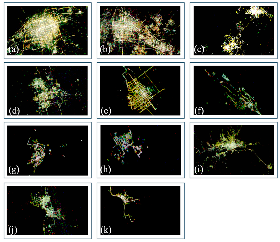

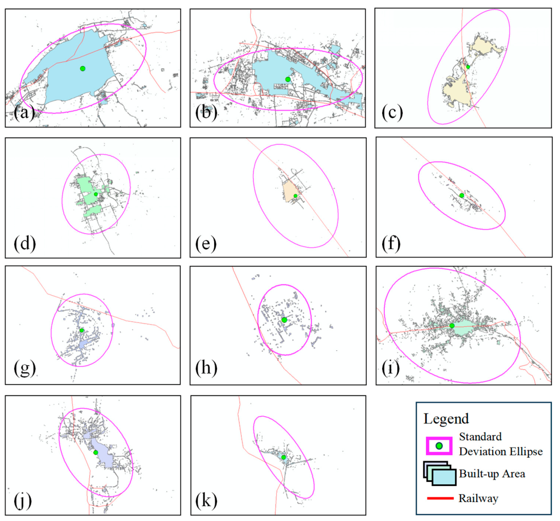


| Dataset | Spatial Resolution | Data Source |
|---|---|---|
| SDGSAT-1 nighttime light data | 10-m panchromatic 2023 | International Research Center of Big Data for Sustainable Development Goals |
| ESRI Land Use Land Cover (LULC) product | 10-m LULC data, 2023 | Environmental Systems Research Institute, Inc. (Redlands, CA, USA, https://livingatlas.arcgis.com/landcoverexplorer. (accessed on 13 June 2026)) |
| Road vector data (OSM) | Vector Data 2023 | OpenStreetMap (https://www.openstreetmap.org. (accessed on 13 June 2026)) |
| POI vector data (OSM) | Vector Data 2023 | OpenStreetMap (https://www.openstreetmap.org) |
| Population Distribution Data | Statistical Data 2023 | World Pop (https://www.worldpop.org. (accessed on 13 June 2026)) |
| Gross Domestic Product (GDP) | Statistical Data 2023 | Kummu, Kosonen. and Masoumzadeh. 2025. (https://doi.org/10.5281/zenodo.10976733. (accessed on 13 June 2026)) |
| China (Inner Mongolia) and Mongolia Statistics Data | Statistical Data 2023 | World Data Bank official website (https://databank.worldbank.org/. (accessed on 15 June 2026)) |
| System Level | Indicator Level | Indicator Descriptions | Properties |
|---|---|---|---|
| Economy Development | GDP per capita (USD) | GDP/Population | + |
| Population | Population inside city administrative boundaries | + | |
| Saved at a bank or similar financial institution (% of population) | The percentage of respondents who report saving or setting aside any money at a bank or similar financial institution in the past year. | + | |
| Gini index | The extent to which the distribution of income among individuals or households within an economy deviates from a perfectly equal distribution. | - | |
| Poverty headcount ratio at $3.00 a day (% of population) | Poverty headcount ratio at $3.00 a day is the percentage of the population living on less than $3.00 a day at purchasing power adjusted prices. | - | |
| GDP (annual % growth) | The percentage change over each previous year of the constant price series in United States dollars. | + | |
| Total Revenue and Grants (USD) | Dataset: Macro Poverty Outlook. Refer to: https://www.worldbank.org/en/publication/macro-poverty-outlook. (accessed on 14 July 2026) | + | |
| Gross Fixed Investment as percentage of GDP | Dataset: Macro Poverty Outlook. Refer to: https://www.worldbank.org/en/publication/macro-poverty-outlook. (accessed on 14 July 2026) | + | |
| Capital and Financial Account Balance (USD) | Dataset: Macro Poverty Outlook. Refer to: https://www.worldbank.org/en/publication/macro-poverty-outlook. (accessed on 14 July 2026) | + | |
| General Government Debt Stock (% of GDP) | Dataset: Macro Poverty Outlook. Refer to: https://www.worldbank.org/en/publication/macro-poverty-outlook. (accessed on 14 July 2026) | - | |
| Private Consumption (% of GDP) | Dataset: Macro Poverty Outlook. Refer to: https://www.worldbank.org/en/publication/macro-poverty-outlook. (accessed on 14 July 2026) | + | |
| Inflation Rate | Dataset: Macro Poverty Outlook. Refer to: https://www.worldbank.org/en/publication/macro-poverty-outlook. (accessed on 14 July 2026) | - | |
| Population growth (annual %) | Annual population growth rate for year t is the exponential rate of growth of midyear population from year t-1 to t, expressed as a percentage. | + | |
| Social Development | Number of traffic facilities (Count) | Number of traffic facilities (Count) based on OSM traffic facilities vector data | + |
| Number of roads (Count) | Number of roads (Count) based on OSM roads vector data | + | |
| Number of motorways (highways) (Count) | Number of motorways (highways) (Count) based on OSM roads vector data | + | |
| Number of hospitals (Count) | Number of hospitals (Count) based on OSM POI vector data | + | |
| Number of public facilities (Count) | Number of public facilities (Count) based on OSM POI vector data | + | |
| Number of commercial facilities (Count) | Number of commercial facilities (Count) based on OSM POI vector data | + | |
| Number of railway (Count) | Number of railway (Count) based on OSM railway vector data | + | |
| Life expectancy at birth, total (years) | The number of years a newborn infant would live if prevailing patterns of mortality at the time of its birth were to stay the same throughout its life. | + | |
| Level of water stress: freshwater withdrawal as a proportion of available freshwater resources (% of freshwater resources) | Freshwater withdrawal as a proportion of available freshwater resources is the ratio between total freshwater withdrawn by all major sectors and total renewable freshwater resources, after considering environmental water requirements. | - | |
| Greenhouse gas (GHG) emissions caused by the transportation sector (Tonnes of CO2-equivalent) | Source: Climate Watch (World Resources Institute), World Resources Institute (WRI) | - | |
| Percentage of individuals using the internet (ITU) (% of population) | Proportion of individuals who used the Internet from any location in the last three months. Access can be via a fixed or mobile network. | + | |
| Global Cybersecurity Index—Overall Score (ITU GCI) | The Global Cybersecurity Index (GCI) measures the commitment of countries to cybersecurity along five pillars: (i) Legal Measures, (ii) Technical Measures, (iii) Organizational Measures, (iv) Capacity Development, and (v) Cooperation. | + | |
| Used a mobile phone or the internet to pay bills, population 25+, cumulative (% of population) | The percentage of respondents who report using a mobile phone or the internet to pay bills in the past year. | + | |
| Educational attainment, at least Master’s or equivalent, population 25+, cumulative (% of population) | The percentage of population ages 25 and over that attained or completed Master’s or equivalent. | + | |
| Physicians (per 1000 people) (Count) | Generalist and specialist medical practitioners. | + | |
| Domestic general government health expenditure (% of GDP) | Public expenditure on health from domestic sources as a share of the economy as measured by GDP. | + | |
| Human Capital Index Plus (HCI+): Health Pillar Score | The HCI Plus Health pillar captures productivity effects of surviving to working age and achieving adequate early-life physical growth. | + | |
| Human Capital Index Plus (HCI+): Education Pillar Score | The HCI Plus Education pillar aggregates human capital accumulated during formal schooling. | + | |
| Universal Health Coverage (UHC) service coverage index | A composite index representing coverage of essential health services based on 14 tracer indicators in the areas of reproductive, maternal, newborn, and child health, infectious diseases, noncommunicable diseases, and service capacity and access. | + | |
| Unemployment Rate | Unemployment refers to the share of the labor force that is without work but available for and seeking employment. | - | |
| GCI 4.0: Electrification rate (% of population) | The percentage of population that has access to electricity. Refer to: World Economic Forum (WEF) | + |
| Cities | I-Economy | I-Society |
|---|---|---|
| Hohhot | 0.85 | 1.00 |
| Baotou | 0.90 | 0.93 |
| Ordos | 1.00 | 0.84 |
| Ulanqab | 0.64 | 0.65 |
| Erenhot | 0.30 | 0.15 |
| Zamyn-Uud | 0.06 | 0.09 |
| Saynshand | 0.04 | 0.36 |
| Choir | 0.05 | 0.43 |
| Ulaanbaatar | 0.37 | 0.90 |
| Darkhan | 0.03 | 0.51 |
| Sukhbaatar | 0.00 | 0.00 |
| Cities | Fractal Dimension | Compactness | Urban Built-Up Area Activity Ratio |
|---|---|---|---|
| Hohhot | 1.300 | 0.047 | 0.91 |
| Baotou | 1.398 | 0.021 | 0.87 |
| Ordos | 1.293 | 0.020 | 0.86 |
| Ulanqab | 1.369 | 0.033 | 0.85 |
| Erenhot | 1.287 | 0.081 | 0.95 |
| Zamyn-Uud | 1.428 | 0.044 | 0.96 |
| Saynshand | 1.412 | 0.045 | 0.94 |
| Choir | 1.420 | 0.052 | 0.92 |
| Ulaanbaatar | 1.467 | 0.012 | 0.79 |
| Darkhan | 1.397 | 0.038 | 0.99 |
| Sukhbaatar | 1.383 | 0.057 | 0.96 |
| Cities | The City Development Index (CDI) |
|---|---|
| Hohhot | 0.77 |
| Baotou | 0.82 |
| Ordos | 0.73 |
| Ulanqab | 0.66 |
| Erenhot | 0.58 |
| Zamyn-Uud | 0.43 |
| Saynshand | 0.50 |
| Choir | 0.55 |
| Ulaanbaatar | 0.63 |
| Darkhan | 0.52 |
| Sukhbaatar | 0.42 |
| Cities | CDI | CDI (Excluding Pn Factor) | CDI (Excluding Qn Factor) | CDI (Excluding I-Economy Factor) | CDI (Excluding I-Society Factor) |
|---|---|---|---|---|---|
| Hohhot | 0.77 | 0.70521 | 0.94495 | 0.75117 | 0.57866 |
| Baotou | 0.82 | 0.79969 | 0.9077 | 0.80618 | 0.68401 |
| Ordos | 0.73 | 0.66992 | 0.89212 | 0.66388 | 0.5742 |
| Ulanqab | 0.66 | 0.56321 | 0.74548 | 0.66314 | 0.58861 |
| Erenhot | 0.58 | 0.48055 | 0.43974 | 0.64458 | 0.72219 |
| Zamyn-Uud | 0.43 | 0.23817 | 0.3959 | 0.51413 | 0.54856 |
| Saynshand | 0.50 | 0.34662 | 0.49308 | 0.60996 | 0.54166 |
| Choir | 0.55 | 0.4087 | 0.52731 | 0.66692 | 0.57988 |
| Ulaanbaatar | 0.63 | 0.50885 | 0.80551 | 0.6961 | 0.46887 |
| Darkhan | 0.52 | 0.37754 | 0.54773 | 0.63686 | 0.5071 |
| Sukhbaatar | 0.42 | 0.2422 | 0.33088 | 0.51826 | 0.58238 |
| Cities | CDI (Excluding Pn Factor) | CDI (Excluding Qn Factor) | CDI (Excluding I-Economy Factor) | CDI (Excluding I-Society Factor) |
|---|---|---|---|---|
| Hohhot | −0.06479 | 0.17495 | −0.01883 | −0.19134 |
| Baotou | −0.02031 | 0.0877 | −0.01382 | −0.13599 |
| Ordos | −0.06008 | 0.16212 | −0.06612 | −0.1558 |
| Ulanqab | −0.09679 | 0.08548 | 0.00314 | −0.07139 |
| Erenhot | −0.09945 | −0.14026 | 0.06458 | 0.14219 |
| Zamyn-Uud | −0.19183 | −0.0341 | 0.08413 | 0.11856 |
| Saynshand | −0.15338 | −0.00692 | 0.10996 | 0.04166 |
| Choir | −0.1413 | −0.02269 | 0.11692 | 0.02988 |
| Ulaanbaatar | −0.12115 | 0.17551 | 0.0661 | −0.16113 |
| Darkhan | −0.14246 | 0.02773 | 0.11686 | −0.0129 |
| Sukhbaatar | −0.1778 | −0.08912 | 0.09826 | 0.16238 |
| Cities | CDI (Excluding Pn Factor) | CDI (Excluding Qn Factor) | CDI (Excluding I-Economy Factor) | CDI (Excluding I-Society Factor) |
|---|---|---|---|---|
| Hohhot | downgrade | unchanged | unchanged | downgrade |
| Baotou | unchanged | unchanged | unchanged | downgrade |
| Ordos | unchanged | upgrade | unchanged | downgrade |
| Ulanqab | unchanged | unchanged | unchanged | unchanged |
| Erenhot | downgrade | downgrade | unchanged | unchanged |
| Zamyn-Uud | downgrade | unchanged | upgrade | upgrade |
| Saynshand | downgrade | downgrade | unchanged | unchanged |
| Choir | downgrade | unchanged | unchanged | unchanged |
| Ulaanbaatar | unchanged | upgrade | unchanged | downgrade |
| Darkhan | downgrade | unchanged | unchanged | unchanged |
| Sukhbaatar | downgrade | unchanged | upgrade | upgrade |
| Cities | CDI Results from SDGSAT-1 | CDI Results from VIIRS | Accuracy of VIIRS |
|---|---|---|---|
| Hohhot | 0.77 | 0.59 | 0.76 |
| Baotou | 0.82 | 0.77 | 0.93 |
| Ordos | 0.73 | 0.56 | 0.77 |
| Ulanqab | 0.66 | 0.52 | 0.78 |
| Erenhot | 0.58 | 0.22 | 0.38 |
| Zamyn-Uud | 0.43 | 0.11 | 0.26 |
| Saynshand | 0.50 | 0.24 | 0.48 |
| Choir | 0.55 | 0.29 | 0.53 |
| Ulaanbaatar | 0.63 | 0.35 | 0.56 |
| Darkhan | 0.52 | 0.27 | 0.52 |
| Sukhbaatar | 0.42 | 0.15 | 0.36 |
| Cities | Precision (VIIRS) | Recall (VIIRS) | Overall Accuracy (VIIRS) | F1-Score (VIIRS) |
|---|---|---|---|---|
| Hohhot | 0.71 | 0.69 | 0.66 | 0.69 |
| Ordos | 0.62 | 0.67 | 0.61 | 0.64 |
| Ulaanbaatar | 0.68 | 0.51 | 0.57 | 0.58 |
| Total Average | 0.67 | 0.62 | 0.61 | 0.64 |
Disclaimer/Publisher’s Note: The statements, opinions and data contained in all publications are solely those of the individual author(s) and contributor(s) and not of MDPI and/or the editor(s). MDPI and/or the editor(s) disclaim responsibility for any injury to people or property resulting from any ideas, methods, instructions or products referred to in the content. |
© 2026 by the authors. Licensee MDPI, Basel, Switzerland. This article is an open access article distributed under the terms and conditions of the Creative Commons Attribution (CC BY) license.
Share and Cite
Sun, Z.; Wang, J.; Li, C.; Jiang, J.; Tuya, W. Urban Development Detection Along the Transportation Corridors of the Mongolian Plateau Supported by SDGSAT-1 NTL Data. Remote Sens. 2026, 18, 2380. https://doi.org/10.3390/rs18142380
Sun Z, Wang J, Li C, Jiang J, Tuya W. Urban Development Detection Along the Transportation Corridors of the Mongolian Plateau Supported by SDGSAT-1 NTL Data. Remote Sensing. 2026; 18(14):2380. https://doi.org/10.3390/rs18142380
Chicago/Turabian StyleSun, Zhichen, Juanle Wang, Congrong Li, Jinbao Jiang, and Wulan Tuya. 2026. "Urban Development Detection Along the Transportation Corridors of the Mongolian Plateau Supported by SDGSAT-1 NTL Data" Remote Sensing 18, no. 14: 2380. https://doi.org/10.3390/rs18142380
APA StyleSun, Z., Wang, J., Li, C., Jiang, J., & Tuya, W. (2026). Urban Development Detection Along the Transportation Corridors of the Mongolian Plateau Supported by SDGSAT-1 NTL Data. Remote Sensing, 18(14), 2380. https://doi.org/10.3390/rs18142380