1. Introduction
Remote sensing imagery contains rich spectral, spatial, and temporal information, providing essential data support for a wide range of Earth observation applications, such as land-use classification, target recognition, environmental monitoring, disaster assessment, and urban planning [
1,
2]. In recent years, deep learning-based computer vision methods have achieved substantial progress in predefined remote sensing tasks, including object detection and scene classification [
3]. However, these methods are usually designed for fixed task settings and closed output spaces, which limits their ability to respond to open-ended user queries. Such queries often require the joint understanding of visual content, natural language semantics, and spatial relationships. For example, answering the question “How many buildings in this region were damaged after the flood?” requires region localization, fine-grained object recognition, spatial reasoning, and free-form answer generation.
Visual Question Answering (VQA) provides a natural human–computer interaction paradigm by allowing users to query image content through natural language and obtain corresponding answers [
4]. In the remote sensing domain, Remote Sensing Visual Question Answering (RS-VQA) is particularly valuable for disaster response, urban governance, environmental assessment, and land resource monitoring [
5]. Early RS-VQA methods mainly adopted classification-based formulations, where answers were selected from a predefined candidate set [
6,
7]. Although these methods demonstrate the feasibility of RS-VQA, their closed-vocabulary design restricts free-form answer generation and makes it difficult to handle questions involving multi-step reasoning or fine-grained spatial understanding [
8].
The rapid development of multimodal large language models has provided new opportunities for overcoming these limitations. Vision–language models (VLMs) extend large language models with visual perception modules, enabling image understanding and natural language interaction in a unified architecture [
9]. These models have shown strong performance on general-domain VQA benchmarks [
10]. With their introduction into remote sensing scenarios, recent studies have begun to explore natural language-based interpretation and analysis of geospatial data [
8]. For example, GeoChat [
11] and SkyEyeGPT [
12] employ instruction tuning on remote sensing datasets to support conversational tasks such as image captioning, visual grounding, and visual question answering. SkySenseGPT [
13] adopts a typical vision–language architecture by combining a Contrastive Language–Image Pre-training (CLIP) visual encoder with a large language model, and applies Low-Rank Adaptation (LoRA) fine-tuning on a large-scale instruction dataset covering classification, VQA, and object detection tasks.
Despite these advances, both general-domain VLMs and remote sensing VLMs still face notable challenges in RS-VQA, especially for ultra-high-resolution imagery [
14,
15]. This limitation mainly stems from two factors. First, remote sensing images often contain thousands of pixels in height and width. When such images are resized to meet the fixed input resolution of VLMs, many small objects and local visual clues may be compressed or lost [
10,
16]. Second, remote sensing scenes exhibit substantial scale variation. A single image may contain both large geographic structures and tiny objects, which places high demands on multi-scale visual perception [
17,
18]. Many existing remote sensing VLMs still follow a passive perception paradigm, where the whole image is processed in a single forward pass. This strategy may overlook question-relevant local details in ultra-high-resolution images, thereby limiting reasoning and answer generation in complex RS-VQA tasks [
19].
To enhance reasoning in remote sensing scenarios, recent studies have investigated reasoning-enhanced VLMs. Chain-of-Thought (CoT) prompting encourages models to generate intermediate reasoning steps and has been shown to improve multimodal problem solving [
20]. In RS-VQA, RS-EoT [
21] proposes a language-driven multi-turn image interaction strategy to reduce premature conclusions. CoT-GeoReason [
22] guides models to sequentially perform feature detection, spatial analysis, and answer synthesis, achieving favorable results on the EarthVQA benchmark [
23]. These studies indicate that explicit reasoning mechanisms can improve the understanding of complex geospatial questions.
Building upon this direction, tool-use mechanisms have been introduced to enable models to actively acquire local visual evidence rather than relying only on a single global image input. In the active perception paradigm, a model can dynamically invoke cropping or zooming tools according to the question, progressively shifting from global observation to local inspection. This process is better suited to fine-grained evidence acquisition in ultra-high-resolution imagery. In addition to studies on tool use and multimodal reasoning [
24,
25,
26], recent works have further explored active visual perception for high-resolution or geospatial vision–language tasks. For example, VisionThink [
27] enables models to request higher-resolution regions when necessary; DeepEyes [
28] studies iterative “thinking with images”; ZoomEarth [
29] introduces an adaptive cropping–zooming framework based on GRPO; RSThinker [
30] constructs perception-grounded geospatial reasoning trajectories; and GeoEyes [
31] analyzes tool-invocation homogenization and evidence-based reward design. Different from ZoomEarth, which mainly focuses on adaptive cropping and zooming, our method treats cropping as an explicit tool-use action for VHR RS-VQA and combines structured prompting, teacher-guided SFT, GRPO-based policy optimization, and region-aware reward design to optimize both crop selection and answer generation. These studies provide useful references for active perception in remote sensing scenarios, but challenges remain in stable crop-tool invocation, fine-grained evidence localization, and efficient reasoning under ultra-high-resolution inputs.
Although RS-VQA has gradually evolved from passive perception to active perception, several challenges remain unresolved. First, question-relevant evidence in ultra-high-resolution remote sensing images is often distributed in local regions, requiring models to identify fine-grained visual clues under global semantic guidance. Second, active perception requires not only accurate answer generation but also stable and executable tool invocation; otherwise, multi-turn perception and reasoning cannot be reliably maintained. Third, although human-annotated crop boxes provide useful supervision, directly training small-scale VLMs to perform multi-turn crop-based reasoning remains difficult. Fourth, during reinforcement learning, traditional Intersection over Union (IoU)-based rewards may suffer from sparsity, while insufficient constraints on tool-use cost can lead to redundant cropping and reduced inference efficiency.
To address these challenges, this paper investigates fine-grained evidence acquisition and active reasoning for ultra-high-resolution RS-VQA. We propose a crop-tool-augmented active perception framework that integrates structured prompting, teacher-guided cold-start supervised fine-tuning (SFT), and GRPO-based reinforcement learning. Specifically, special tokens are introduced to regulate the model’s thinking, cropping, and answering behaviors, allowing the reasoning process to be expressed in a structured and executable form. A teacher model is then used to generate high-quality multi-turn crop-based reasoning trajectories for cold-start SFT of a small-scale VLM. Finally, we design a reward function tailored to the spatial characteristics of remote sensing imagery, further optimizing region selection, tool-use rationality, and final answer accuracy under GRPO-based reinforcement learning.
The main contributions of this paper are summarized as follows:
We propose a structured active perception framework for ultra-high-resolution RS-VQA. By introducing special tokens such as <think>, <crop>, and <answer>, the model’s reasoning process is organized into explicit stages, including reasoning, crop decision-making, local evidence acquisition, and answer generation. This design improves the model’s ability to focus on question-relevant fine-grained regions.
We design a teacher-guided cold-start SFT strategy for crop-tool-based reasoning. Based on high-resolution images, question–answer pairs, and human-annotated crop boxes from the LRS-GRO dataset, Seed 1.6 is used to generate multi-turn crop-based reasoning trajectories. These trajectories help Qwen2.5-VL-3B learn structured reasoning patterns, executable tool invocation formats, and local-evidence-based answer generation.
We introduce GRPO-based reinforcement learning to optimize the active perception policy and design a reward function adapted to remote sensing spatial characteristics. The reward integrates format constraints, region coverage, answer semantic consistency, and cropping penalties, thereby alleviating IoU reward sparsity and reducing redundant crop-tool invocations while improving region selection quality and final RS-VQA performance.
2. Materials and Methods
2.1. Training Dataset
This study uses the LRS-GRO dataset as the primary training resource [
29]. LRS-GRO is designed for active perception-based RS-VQA on ultra-high-resolution imagery, emphasizing a model’s ability to perform semantic understanding, region localization, and fine-grained reasoning over large-scale images. Unlike conventional RS-VQA datasets that focus mainly on global scene comprehension, LRS-GRO encourages models to actively attend to question-relevant regions, making it well-suited for vision–language models with tool-use and region-cropping capabilities.
The dataset aggregates images from multiple public remote sensing sources, including FAIR1M-1.0, GLH-Bridge, and STAR [
32,
33,
34], covering diverse scenarios such as airports, bridges, ports, industrial sites, urban regions, and rural areas. In total, LRS-GRO contains 1224 high-resolution images with resolutions ranging from 4000 to 5000 pixels, each encompassing extensive geographic coverage and numerous fine-grained objects. The dataset provides 3592 annotated bounding boxes and 13,245 VQA samples. Bounding boxes are organized hierarchically into region-level and object-level annotations. Region-level boxes represent semantically coherent areas composed of multiple objects (e.g., airports or industrial zones), while object-level boxes correspond to individual entities with homogeneous semantics (e.g., airplanes, ships, buildings, bridges). This hierarchy facilitates learning of both region selection and multi-scale visual reasoning.
LRS-GRO structures VQA tasks across three spatial levels—global, region, and object—spanning 17 question types. The global level assesses overall scene comprehension, the region level emphasizes localized semantic reasoning, and the object level targets fine-grained attributes and relationships of individual entities. This multi-level design challenges models to reason across spatial scales and dynamically identify relevant regions, effectively evaluating active perception and fine-grained reasoning capabilities.
2.2. Structured Reasoning and Tool-Use Framework
Early studies on tool-augmented large language models mainly relied on predefined triggering rules or externally controlled tool-use strategies. In such settings, the model itself had limited ability to determine when and how external tools should be invoked [
24,
25]. Recent reasoning-oriented models have shown that explicitly generating intermediate reasoning steps, commonly formulated as Chain-of-Thought (CoT), can improve performance on complex tasks [
26,
35,
36]. This test-time reasoning paradigm suggests that allocating additional computation to structured reasoning during inference can benefit multimodal understanding, particularly in remote sensing scenarios that require spatial analysis and evidence localization.
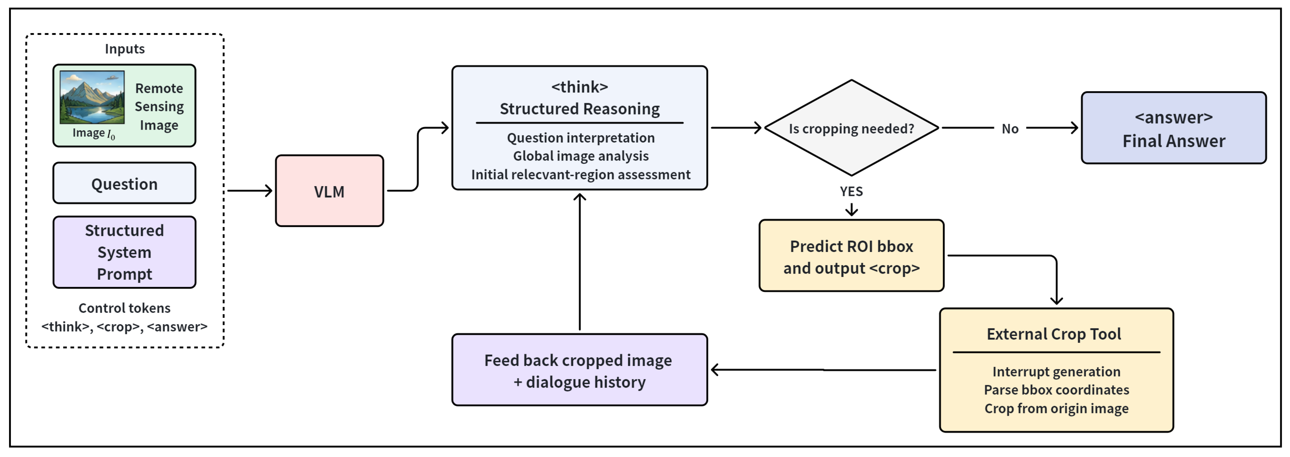
Motivated by this idea, we design a structured system prompt for RS-VQA that integrates crop-tool invocation into the generation process through specialized control tokens [
20,
22,
29,
31]. The prompt constrains the model’s output to follow a stepwise procedure of “reasoning–decision–execution–answering”. As shown in
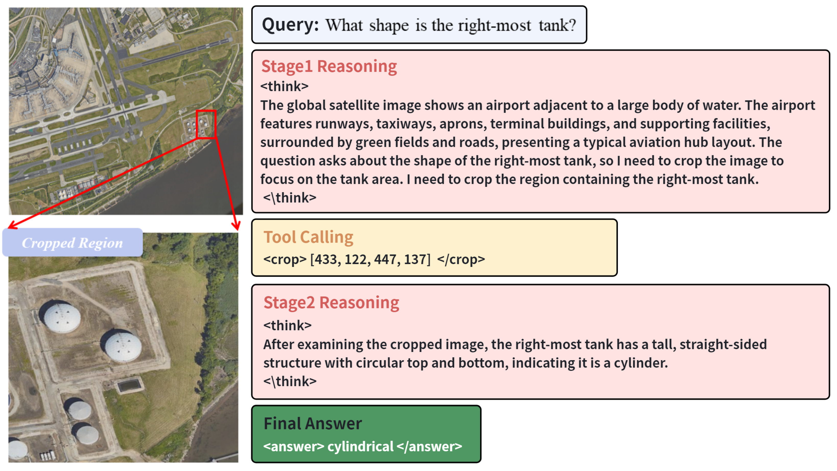
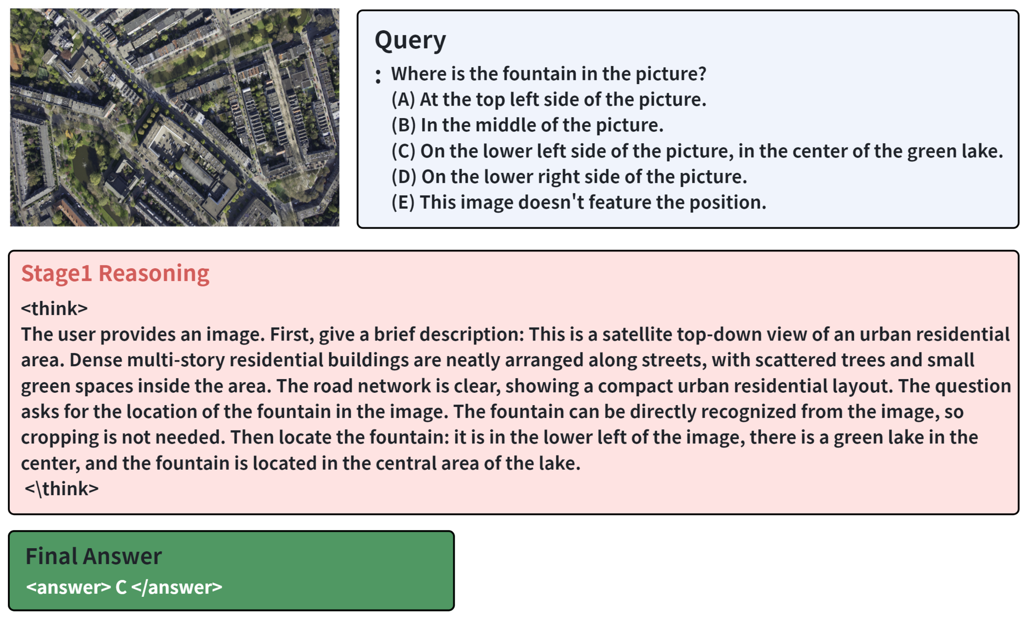
Figure 1, the model first analyzes the input image and question, then decides whether local visual evidence is necessary. If the global image already provides sufficient information, the model directly produces the final answer. Otherwise, it predicts a region of interest and invokes the cropping tool to obtain a localized image for further analysis.
Specifically, we introduce three special tokens, namely
<think>,
<crop>, and
<answer>. The
<think> token elicits structured reasoning, including question intent interpretation, global scene analysis, and preliminary identification of potentially relevant regions [
20,
26,
27]. This stage encourages the model to integrate available information before making a tool-use decision or generating the final answer, thereby reducing the instability of direct response generation.
If the model determines during the
<think> stage that the current visual input is insufficient, it predicts a region of interest and outputs the corresponding bounding-box coordinates within the
<crop> token. The
<crop> token serves as an executable trigger for crop-tool invocation [
24,
25,
29,
31]. Once this token is detected, the system pauses generation, parses the enclosed coordinates, and crops the corresponding region from the original remote sensing image using an external Python-based tool. The cropped image is then returned to the model as an updated visual input together with the dialogue history, forming a multi-turn active perception process.
After receiving the cropped image, the model continues reasoning based on the localized evidence. This iterative procedure enables fine-grained visual analysis and progressively refines the answer. When sufficient evidence has been acquired, the model outputs the final result within the <answer> token. The answer is expressed in concise natural language for subsequent parsing and evaluation. By parsing the sequence of special tokens, the system can record the reasoning trajectory, crop-tool behavior, and final prediction in a unified structured format.
Overall, the proposed prompt design explicitly incorporates active perception into the generative reasoning process [
29,
30,
31]. It enables the model to reason before deciding whether to invoke the cropping tool, thereby improving local evidence acquisition in complex remote sensing scenes. Moreover, the structured representation of intermediate reasoning steps and region-selection behavior provides interpretable and verifiable signals, which are further used for reinforcement learning optimization.
2.3. Cold-Start SFT with Teacher-Generated CoT
We adopt Qwen2.5-VL-3B as the backbone model for training [
37]. Qwen2.5-VL follows a multimodal architecture that integrates a vision encoder with a large language model, enabling unified modeling of visual and textual inputs. Unlike conventional VLMs that rely on fixed-resolution preprocessing, Qwen2.5-VL introduces a dynamic-resolution mechanism that adaptively generates visual tokens according to the original image size. This design helps preserve fine-grained visual details in high-resolution images while maintaining computational efficiency. These properties make Qwen2.5-VL-3B suitable for integration with our crop-tool-augmented active perception framework, where both global scene understanding and local evidence analysis are required.
However, the original Qwen2.5-VL-3B model is not explicitly optimized for structured reasoning or tool invocation (
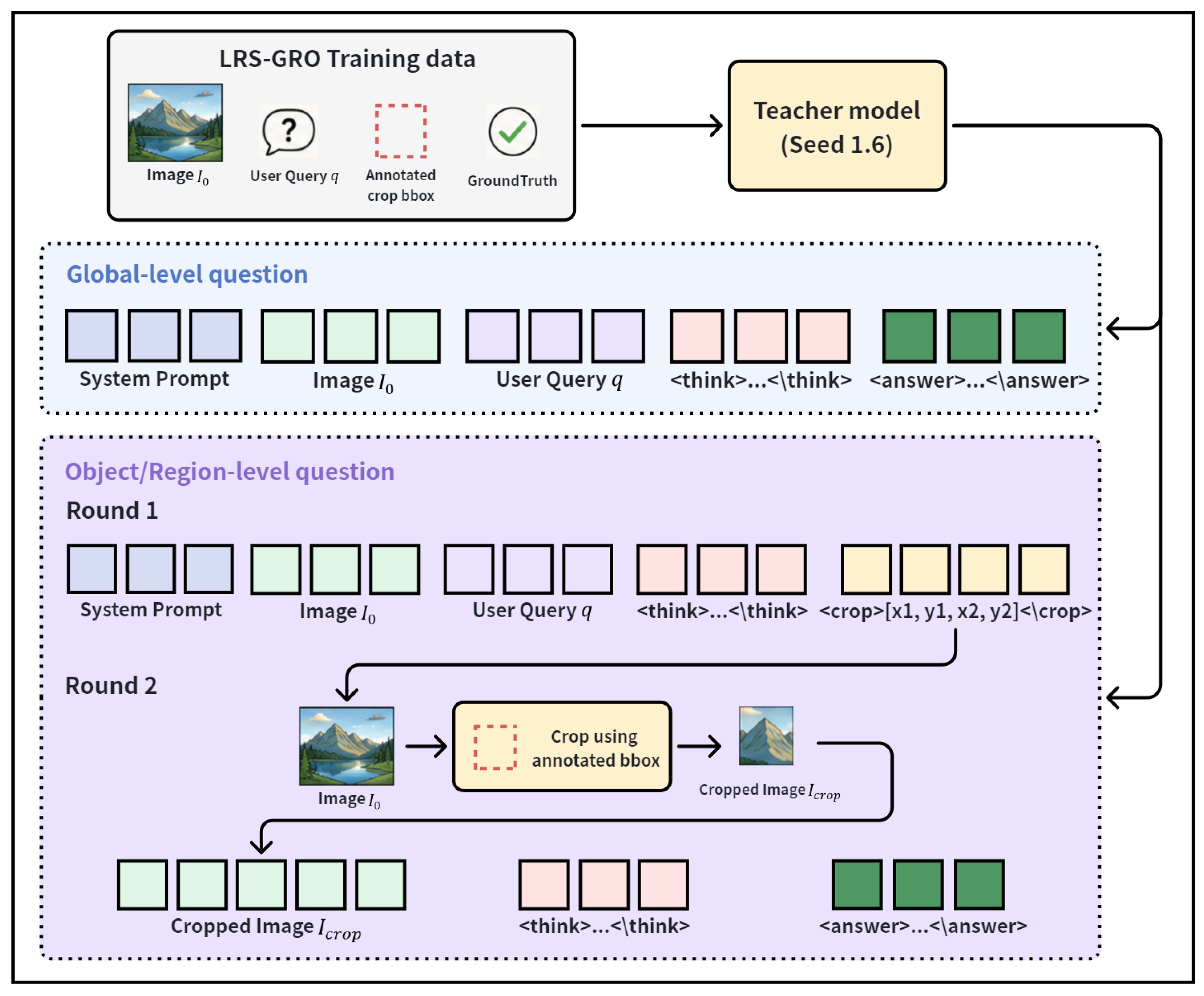
Appendix A). Due to its limited model scale, it may fail to consistently follow system prompts that require multi-step reasoning traces, predefined special tokens, and executable crop-tool instructions. To address this issue, we introduce a teacher-guided cold-start supervised fine-tuning strategy, as shown in
Figure 2 [
24,
25,
26]. Specifically, we use high-resolution images, manually annotated crop boxes, and ground-truth answers from the LRS-GRO training set, and employ Seed 1.6 as the teacher model to generate structured multi-turn reasoning trajectories [
29,
38]. These trajectories provide explicit demonstrations of reasoning, crop-tool invocation, and local-evidence-based answer generation, enabling the student model to acquire preliminary active perception capabilities during the cold-start stage.
The teacher model is guided by a carefully designed prompt and is required to follow the predefined output format specified by the system prompt. Given an image-question pair, the teacher first provides a concise description of the global image context. It then analyzes the question and determines whether local visual evidence is needed. For region-level and object-level questions, the teacher generates crop-based reasoning trajectories, including target localization, justification for cropping, and coordinate prediction. For global-level questions, the teacher is instructed to complete the reasoning process without invoking the cropping tool and to directly generate the final answer.
For questions requiring local evidence, the teacher outputs the annotated bounding box from the training set in the first reasoning round, enclosed within the special token
<crop> [
29,
37]. Since Qwen2.5-VL uses absolute coordinates to represent spatial regions during pretraining, we retain this coordinate format to avoid additional normalization and denormalization operations. This design reduces the learning difficulty associated with mapping between tool invocation formats and spatial locations. The original image is then cropped according to the predicted coordinates, and the resulting local region is fed back to the teacher as the second-round visual input. Based on this localized evidence, the teacher continues reasoning and generates the final answer. In this way, the constructed trajectories teach the student model not only how to answer questions, but also when to invoke the cropping tool, which region to select, and how to use local visual evidence for reasoning.
After constructing the cold-start trajectory dataset, we perform supervised fine-tuning on Qwen2.5-VL-3B within the proposed active perception framework. Let the teacher-generated dataset be denoted as
where
represents the original high-resolution image,
q denotes the user query, and
denotes a multi-turn trajectory with
T interaction rounds. Here,
is the reasoning text at step
t,
represents the visual input at step
t, and
a is the final answer.
The SFT objective is defined as the negative log-likelihood loss:
Here,
consists of the system prompt, visual tokens generated by the dynamic-resolution encoder, and the user query, while
denotes the target output sequence containing reasoning text, special tokens such as
<think> and
<crop>, and the final answer. For trajectories involving cropping, the second-round visual input corresponds to the cropped local image
. The model is trained to first generate a valid crop instruction, such as
<crop>x1, y1, x2, y2</crop>, and then continue reasoning based on the returned local evidence.
To improve training efficiency while preserving the general capability of the backbone model, we adopt Low-Rank Adaptation (LoRA) for parameter-efficient fine-tuning [
39]. Specifically, low-rank decomposition matrices are inserted into the Transformer attention modules and multilayer perceptron layers. For a pretrained weight matrix
, LoRA parameterizes the updated weight as follows:
where
,
, and
. During fine-tuning, only the low-rank matrices
A and
B are optimized, while the original parameters
remain frozen.
2.4. Group Relative Policy Optimization
After cold-start SFT, the model acquires basic abilities in structured reasoning and crop-tool invocation. However, supervised fine-tuning mainly imitates teacher-generated trajectories and does not directly optimize the model’s decision policy according to task-level feedback. In complex ultra-high-resolution RS-VQA scenarios, the model may still select suboptimal regions, invoke the cropping tool unnecessarily, or fail to balance local evidence acquisition with inference efficiency. To further improve its active perception strategy, we introduce Group Relative Policy Optimization (GRPO) for reinforcement learning [
35,
40].
Compared with conventional supervised learning, reinforcement learning enables the model to optimize its generation policy through reward feedback. Compared with Proximal Policy Optimization (PPO), GRPO estimates advantages based on group-relative rewards and removes the need for an additional value network. This design reduces computational overhead and improves training stability.
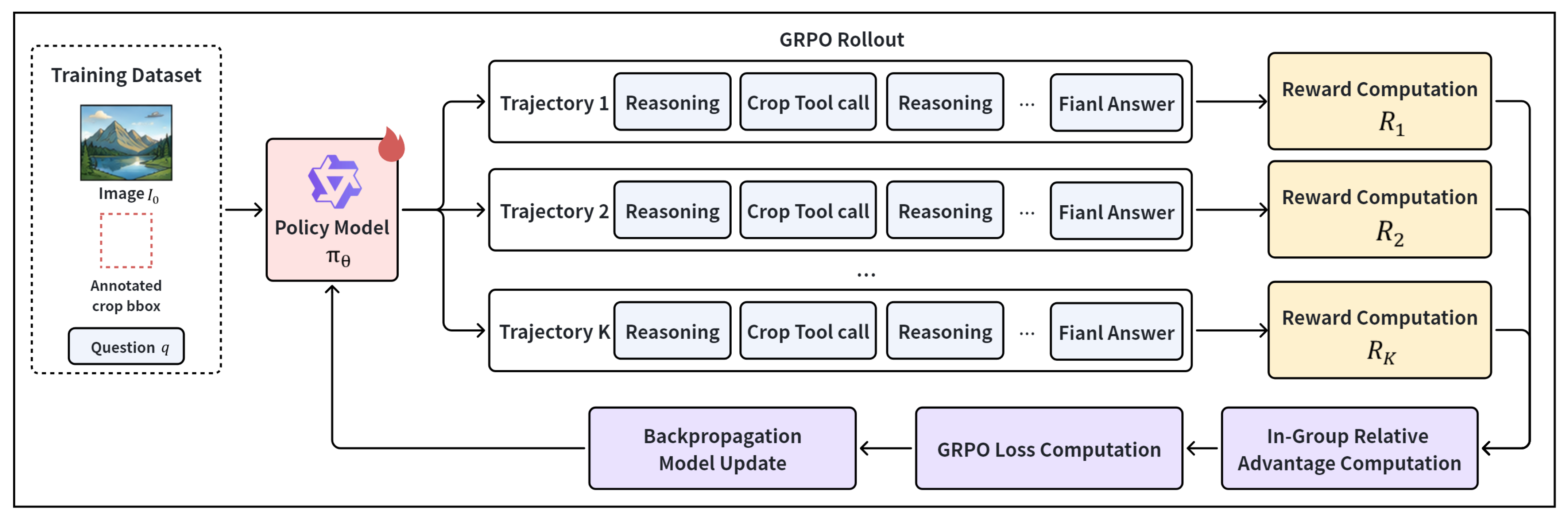
Figure 3 illustrates the GRPO optimization process in our active perception setting.
Given an input image
and a user query
q, the current policy model
generates a group of
K candidate trajectories:
Each trajectory may contain intermediate reasoning steps, crop-tool invocations, and a final answer. The reward function evaluates each trajectory and produces the corresponding reward values:
The group mean and standard deviation are computed as follows:
The normalized advantage for each trajectory is then defined as follows:
where
is a small constant for numerical stability. The GRPO objective with Kullback–Leibler (KL) regularization is formulated as follows:
where
denotes the reference policy obtained after SFT, and
controls the strength of the KL regularization. The KL term constrains the updated policy from deviating excessively from the SFT model, thereby improving training stability.
2.5. Reward Function Design
An effective reward function is critical for learning a robust active perception strategy. Traditional IoU-based rewards evaluate only the geometric overlap between the predicted crop and the reference region [
41]. Although suitable for standard localization tasks, they have several limitations for RS-VQA: early in training, poor localization leads to near-zero IoU, providing sparse feedback; IoU penalizes partial coverage even when the region contains sufficient visual evidence; and IoU measures alignment rather than task relevance.
To address this, we define a region reward that combines reference-region coverage and crop compactness:
where
b is the predicted crop,
is the reference region, and
is the full image. The coverage term ranges in [0, 1] and encourages inclusion of question-relevant evidence; the area term penalizes overly large crops, with
. In all experiments, we set
. If the predicted crop is invalid or non-positive,
is set to 0.
We also define a format reward , which gives a positive score when the output contains valid special tokens (<think>, <crop>, <answer>) and executable crop coordinates; otherwise, it is 0. This ensures structural validity of the reasoning trajectory.
The answer reward
evaluates semantic correctness using an LLM-as-a-judge strategy [
42]:
To regulate tool usage, we introduce a multiplicative cropping penalty:
where
if the trajectory contains a crop invocation, and 0 otherwise;
controls the penalty strength. Thus,
. When no crop is invoked,
; when cropping occurs,
, reducing the effective answer reward. In our experiments, the crop penalty coefficient
is set to 0.1. This value provides a mild penalty for unnecessary crop-tool invocations while still allowing necessary cropping, achieving a reasonable balance between local evidence acquisition and inference efficiency.
The overall reward is then as follows:
where
weights the format reward. In our experiments, we set
, and the coefficient of
is fixed to 1.0 in the composite reward. This formulation clarifies that the crop penalty modulates the answer reward without introducing unintended positive reward.
Intuition and Example. For a global-level question that does not require cropping, the model should rely on the full image. If it unnecessarily invokes cropping, is discounted by , reflecting a minor cost. Conversely, for an object-level question requiring local evidence, invoking the crop tool can increase and help achieve , so the model is rewarded for selective cropping.
2.6. Evaluation Datasets and Metrics
Evaluation Datasets.
Table 1 summarizes the four evaluation datasets used in this study. To evaluate the proposed method under diverse remote sensing scenarios, we conduct experiments on VRSBench, MME-RealWorld-RS, XLRS-Bench, and LRS-VQA [
10,
19,
43,
44]. These benchmarks cover different image resolutions, scene categories, and question types, allowing us to assess general RS-VQA performance, fine-grained visual perception, spatial reasoning, and ultra-high-resolution image analysis.
VRSBench evaluates general vision–language understanding in remote sensing scenes and contains a large number of image-question pairs with moderate image resolution. MME-RealWorld-RS focuses on real-world high-resolution remote sensing imagery and is used to examine model robustness in complex visual environments. XLRS-Bench is designed for ultra-high-resolution remote sensing images, where large spatial coverage and small visual targets pose challenges to region localization and multi-step reasoning. LRS-VQA further emphasizes question answering over large-scale remote sensing scenes and is suitable for evaluating fine-grained evidence acquisition in wide-area imagery. Together, these datasets provide a comprehensive testbed for analyzing the effectiveness of the proposed active perception framework across both standard and high-resolution RS-VQA settings.
Evaluation Metrics. We adopt answer accuracy (Acc) as the primary evaluation metric. For each test sample, the model generates an answer based on the input image and question. The prediction is then compared with the ground-truth answer to determine whether it is correct. However, RS-VQA answers are often expressed in short natural-language phrases, and many questions allow semantically equivalent answers with different surface forms. Therefore, exact string matching or token-level overlap may underestimate model performance.
To obtain a more reliable evaluation for open-ended answers, we employ an LLM-as-a-judge strategy [
42]. Specifically, we use Qwen3-32B as the judging model. For each sample, the question, predicted answer, and ground-truth answer are provided to the judge model. The judge is instructed to determine whether the prediction is semantically consistent with the reference answer and to output a binary decision, i.e., correct or incorrect. The same judging prompt is used for all datasets to ensure consistency across evaluations. The final accuracy is computed as follows:
where
denotes the number of samples judged as correct, and
represents the total number of evaluated samples. Compared with exact string matching, this semantic-consistency-based protocol better reflects answer correctness in open-ended RS-VQA tasks.
3. Results
3.1. Comparative Analysis and Discussion
To evaluate the effectiveness of the proposed method, we compare it with representative VLMs on four RS-VQA benchmarks, including VRSBench, MME-RealWorld-RS, XLRS-Bench, and LRS-VQA [
10,
19,
43,
44]. For compact presentation, MME-RealWorld-RS is abbreviated as MME-RW-RS in the results’ table. The compared models are grouped into three categories: proprietary VLMs, open-source general-purpose VLMs, and remote sensing-specific VLMs.
For proprietary models, we include GPT-4o, GPT-4V, Gemini-2.5-Flash, and Claude 3.5 Sonnet, which have shown strong general visual understanding and reasoning abilities [
45,
46,
47,
48]. For open-source models, we evaluate InternVL, LLaVA-OV, and several Qwen-VL variants with different model scales, including Qwen3-VL models with enhanced reasoning ability [
37,
49,
50,
51,
52]. These models provide strong baselines for assessing general multimodal understanding. We also compare with remote sensing-specific VLMs, including GeoChat, GeoLLaVA, ZoomEarth, SkySenseGPT, and GeoVLM-R1 [
11,
13,
16,
29,
53]. These methods are designed or adapted for geospatial imagery through domain-specific instruction tuning, high-resolution input modeling, crop-based interaction, or reasoning-oriented optimization.
As shown in
Table 2, the proposed method demonstrates strong performance across the four RS-VQA benchmarks, achieving accuracies of 49.8, 43.3, 40.9, and 34.7 on VRSBench, MME-RW-RS, XLRS-Bench, and LRS-VQA, respectively. These values result in a competitive average accuracy of 42.2 across the evaluated benchmarks. Notably, our approach attains the top performance on VRSBench and LRS-VQA, while remaining competitive on MME-RW-RS and XLRS-Bench.
When compared to proprietary VLMs, such as GPT-4o, GPT-4V, Gemini-2.5-Flash, and Claude 3.5 Sonnet, the proposed method achieves a higher average score. Although these models perform well on general-purpose visual understanding tasks, their performance is less consistent on remote sensing benchmarks, particularly in high-resolution scenarios requiring fine-grained region localization. This indicates that incorporating domain-specific active perception and crop-tool-based reasoning can provide substantial benefits for RS-VQA.
The improvement over open-source general-purpose VLMs is even more pronounced. Using Qwen2.5-VL-3B as the backbone, the proposed method increases the average accuracy from 23.2 to 42.2. This suggests that the performance gains arise not merely from model scale, but from the integrated effect of structured reasoning, teacher-guided cold-start SFT, and GRPO-based active perception optimization.
Similarly, compared to remote sensing-specific VLMs, the proposed approach delivers competitive results. Models such as GeoLLaVA-8K and ZoomEarth achieve strong performance on high-resolution benchmarks, underscoring the importance of high-resolution input modeling and localized visual evidence. Nevertheless, our method attains the highest overall average and shows a clear advantage on LRS-VQA, where accurate localization of fine-grained evidence across wide-area scenes is crucial. These results indicate that the crop-tool-augmented active perception strategy effectively enhances RS-VQA performance in large-scale, high-resolution settings.
Overall, the experimental outcomes highlight that the proposed method achieves a balanced improvement across general RS-VQA tasks and high-resolution fine-grained reasoning. The substantial gains over the Qwen2.5-VL-3B backbone further validate the effectiveness of our training pipeline, which combines structured reasoning, teacher-generated crop-based trajectories, and GRPO-based optimization.
3.2. Ablation Studies
To analyze the contribution of each component, we conduct ablation studies from three perspectives: training strategy, cropping mechanism, and reward design.
Table 3 compares different training strategies. Compared with the original Qwen2.5-VL-3B backbone, SFT alone improves the average accuracy from 23.2 to 39.5, yielding an absolute gain of 16.3 points. This result shows that teacher-generated structured trajectories provide an effective cold-start signal, enabling the model to learn basic multi-step reasoning patterns and crop-tool invocation formats.
GRPO alone also improves the backbone model, increasing the average accuracy to 34.8. However, its performance remains lower than that of SFT alone. This suggests that reinforcement learning without sufficient initialization may suffer from unstable exploration, especially when the model needs to simultaneously learn reasoning formats, region selection, and answer generation. When SFT and GRPO are combined, the average accuracy further increases to 42.2, achieving the best results among all training strategies. This indicates that SFT provides a reliable initialization for structured reasoning and tool use, while GRPO further refines the active perception policy through task-level feedback.
Table 4 further examines the effect of cropping under different training paradigms. Under the SFT setting, adding cropping only slightly improves the average accuracy from 39.3 to 39.5. The limited gain indicates that supervised learning can teach the model the basic format of crop-tool invocation, but it does not fully optimize when and where to crop. In particular, the performance on MME-RW-RS decreases after adding cropping, suggesting that inaccurate or unnecessary crop decisions may introduce distracting local evidence and affect answer generation.
In contrast, cropping becomes more beneficial when combined with reinforcement learning. Under the RL setting, the average accuracy increases from 40.5 to 42.2 after introducing cropping, with consistent gains across all four benchmarks. The improvements are especially clear on MME-RW-RS and LRS-VQA, where high-resolution inputs and wide-area scenes require more accurate local evidence acquisition. These results suggest that cropping itself is not always beneficial; its effectiveness depends on whether the model can learn a reasonable crop-selection policy. GRPO helps optimize this policy by rewarding trajectories that select informative regions and produce correct answers.
Overall, the comparison indicates that cropping should be coupled with policy optimization rather than treated as a fixed operation. SFT provides the model with basic executable tool-use behavior, while GRPO improves the timing and spatial precision of crop-tool invocation. This explains why the combination of cropping and reinforcement learning yields the most stable improvement.
We further evaluate the influence of reward design in
Table 5. Replacing the conventional IoU reward with the proposed region reward improves the average accuracy from 39.1 to 40.4. This improvement indicates that the coverage-based formulation provides a denser and more task-oriented supervision signal than strict geometric overlap. By measuring whether the predicted crop contains the reference region while penalizing excessive area, the region reward better matches the evidence-seeking nature of active perception in RS-VQA.
The improvement is observed in Reasoning, Object, and Scene tasks, suggesting that better region selection benefits not only localization but also downstream semantic analysis. The gain on Counting tasks is relatively small, which may be because counting often depends on broader scene-level information rather than a single localized crop. This result also suggests that the role of cropping varies across question types.
Adding the cropping penalty further improves the average accuracy from 40.4 to 40.9. The penalty discourages redundant tool invocation and encourages the model to preserve global context when cropping is unnecessary. This effect is particularly important for Scene questions, where excessive local focus may remove useful contextual information. Meanwhile, the gains in Reasoning and Object tasks suggest that the model learns to invoke cropping more selectively and at more appropriate stages. These results verify that the proposed reward design not only guides the model toward informative regions, but also regulates the cost and necessity of crop-tool use.
4. Discussion
4.1. Method Analysis
High-resolution remote sensing visual question answering presents substantial challenges for conventional vision–language models due to the sparse distribution of informative content and the wide scale variation of key objects. In many scenarios, only a small portion of the image is relevant to the question, while the remaining regions often contain redundant background information that can interfere with reasoning. To address this, we propose an active perception framework that integrates dynamic cropping into the reasoning process of vision–language models. Unlike approaches relying solely on global image representations, the proposed method selectively focuses on task-relevant local regions based on the semantic content of the question, enabling more precise visual understanding during inference.
Experimental results on multiple RS-VQA benchmarks demonstrate consistent performance gains over traditional global-view methods. This improvement indicates that explicitly incorporating region selection into the reasoning pipeline effectively mitigates the impact of irrelevant information in high-resolution imagery. Additionally, the framework enhances the model’s ability to capture fine-grained visual evidence, which is crucial for tasks involving small objects, complex spatial arrangements, or subtle semantic distinctions.
Another key advantage of the proposed framework is its joint modeling of perception and reasoning within a unified decision-making process. Conventional vision–language models typically treat visual encoding as a fixed preprocessing step, while reasoning is performed on the extracted features. In contrast, our method allows reasoning to guide perception, enabling adaptive adjustment of the observation region according to the current question. This active perception mechanism improves reasoning robustness in complex remote sensing scenarios and more closely resembles human visual cognition, where attention is dynamically allocated to informative regions during problem solving.
4.2. Comparison with Existing Methods
Compared with existing remote sensing vision–language models, the proposed method incorporates an explicit and interpretable active perception mechanism at the behavioral level. Methods such as GeoChat primarily enhance semantic understanding through instruction tuning on remote sensing data. Although they perform well on general semantic tasks, their reasoning relies on global image representations and lacks an explicit mechanism to identify question-relevant regions. As a result, when processing high-resolution images with abundant irrelevant content, redundant visual information can negatively affect reasoning performance. GeoVLM-R1 improves answer quality for complex queries by enhancing reasoning capabilities, yet it still relies on globally encoded image features and does not explicitly model spatial information selection. Consequently, despite more sophisticated reasoning, it may struggle to accurately localize key visual evidence in challenging remote sensing scenarios.
In contrast, our framework explicitly integrates cropping operations into the reasoning process, allowing the model to dynamically adjust its perceptual focus based on question semantics and scene complexity. By directly linking perception and reasoning, the model actively identifies informative regions during inference, rather than treating visual encoding and reasoning as separate stages. This unified strategy contributes to more stable performance improvements across datasets and question types.
Compared with ZoomEarth, the proposed method further introduces a cropping penalty during GRPO training, enabling adaptive crop decision-making. Instead of performing cropping indiscriminately, the model learns when and where cropping is necessary, improving both flexibility and efficiency. This is particularly beneficial for questions that can be answered using only global context. Overall, the proposed framework enhances not only region localization but also the model’s ability to autonomously manage its perception behavior.
4.3. Reward Mechanism Analysis
The design of the reward function is central to optimizing crop-tool behavior in the proposed framework. Conventional IoU-based rewards mainly evaluate the geometric overlap between the predicted crop and the annotated region. Although this criterion is suitable for standard localization tasks, it does not fully reflect the task-oriented nature of RS-VQA. In this setting, the selected region should not only overlap with the reference annotation, but also provide visual evidence that is useful for answering the question. Therefore, directly relying on IoU may produce sparse or insufficient learning signals, especially when the predicted crop partially covers the target but fails to obtain a high overlap score.
To alleviate this problem, we introduce a reward mechanism that combines reference-region coverage with an area constraint. The coverage term encourages the model to include question-relevant visual evidence in the selected crop, whereas the area constraint discourages overly large regions that simply cover more content without improving reasoning quality. By balancing these two objectives, the proposed reward guides the model toward compact and informative regions, which is more consistent with the evidence-seeking requirement of active perception in RS-VQA.
In addition, we introduce a cropping penalty to regulate tool invocation. In practical remote sensing scenarios, not every question requires local inspection. Some questions can be answered from the global scene context, and unnecessary cropping may introduce redundant visual evidence, increase inference cost, or even distract the model from the correct reasoning path. The cropping penalty therefore encourages the model to invoke the crop tool more selectively. Instead of treating cropping as a default operation, the model learns to determine whether local evidence is needed according to the question and visual context. This design improves the adaptability of the perception process across different question types.
The proposed reward mechanism also improves the interpretability of the framework. Since crop decisions are explicitly represented and optimized during training, the resulting reasoning process can be inspected through the generated crop coordinates and intermediate outputs. Compared with implicit attention mechanisms, this explicit crop-tool behavior provides more observable evidence for analyzing how the model acquires and uses visual information. Nevertheless, the current reward design mainly focuses on region coverage, crop compactness, answer correctness, and tool-use cost. More fine-grained reward signals, such as those considering multi-step crop trajectories or the semantic sufficiency of selected regions, remain worth further investigation.
4.4. Limitations and Future Work
Although the proposed framework achieves promising results on multiple RS-VQA benchmarks, several limitations remain that warrant further investigation. First, the current training process relies on manually annotated cropping regions, which increases annotation costs and limits scalability to large-scale unlabeled remote sensing datasets. Despite these annotations providing effective supervision for learning crop-tool behavior, constructing high-quality region labels is time-consuming and may not generalize well to diverse or complex scenarios. Future work could explore reinforcement learning or self-supervised strategies that learn region selection policies directly from question–answer supervision, reducing the dependence on explicit cropping annotations and improving scalability in real-world applications.
Second, the framework currently employs a single-step cropping operation. Although this design simplifies decision-making, a single crop may be insufficient to capture all relevant visual evidence in complex scenes containing multiple spatially distributed regions. In such cases, one cropped region might omit critical information needed for accurate reasoning. Future research could investigate multi-step or hierarchical cropping strategies, enabling the model to progressively refine its perception and integrate information from multiple regions during inference.
Third, cropping is the primary visual operation in the current framework. Although effective at reducing redundant information, additional perception mechanisms could further enhance scene understanding. For example, future extensions could incorporate multi-scale feature exploration, cross-region integration, adaptive zooming, or external knowledge retrieval modules. Integrating such capabilities may yield a more comprehensive active perception system for remote sensing multimodal reasoning tasks.
Overall, this work demonstrates that incorporating active region selection into the reasoning process improves RS-VQA performance and provides a new perspective on modeling active perception in multimodal vision–language systems. Addressing the limitations outlined above will be critical for extending the framework to larger-scale datasets, more complex scenes, and richer perception operations in future studies.
5. Conclusions
This paper presents an active perception-based vision–language framework for high-resolution remote sensing visual question answering (RS-VQA), designed to address the challenges posed by sparse informative content, substantial background redundancy, and large-scale variations of key objects in remote sensing images. The framework treats cropping as an explicit visual operation within the reasoning process, enabling the model to selectively focus on question-relevant regions and generate answers based on targeted visual evidence. By dynamically adjusting its perceptual focus according to the task requirements, the model moves beyond reliance on fixed global image representations.
To further enhance region selection, a reward mechanism is introduced that combines region coverage, area constraints, and a cropping penalty. This design encourages the model to prioritize informative regions containing key evidence, discourages excessive or uninformative crops, and guides adaptive cropping decisions depending on the question context. Consequently, the framework establishes a tighter integration between region localization, cropping behavior, and answer reasoning, facilitating a more flexible and interpretable perception process. Experimental results across multiple RS-VQA benchmarks demonstrate competitive performance and improvements in most evaluated settings, validating the effectiveness of incorporating active region selection into high-resolution multimodal understanding. We also observe that the performance gain varies across datasets, indicating that the effectiveness of crop-tool-augmented active perception is influenced by task composition, question difficulty, and the distribution of local visual evidence.
In summary, this work provides a new modeling perspective for RS-VQA by explicitly embedding visual perception behavior into the reasoning pipeline of vision–language models. Beyond improving task performance, this approach offers insights for the development of vision–language systems with dynamic decision-making, interpretable reasoning, and adaptive perception, and lays the groundwork for future research on more sophisticated active perception mechanisms in multimodal remote sensing applications.