Bridging Deep Learning and Ecological Interpretability: A Spatial Mamba Framework for NDVI Prediction in Forest-Steppe Ecotones Under Climate Variability
 ,
,  ,
,
Highlights
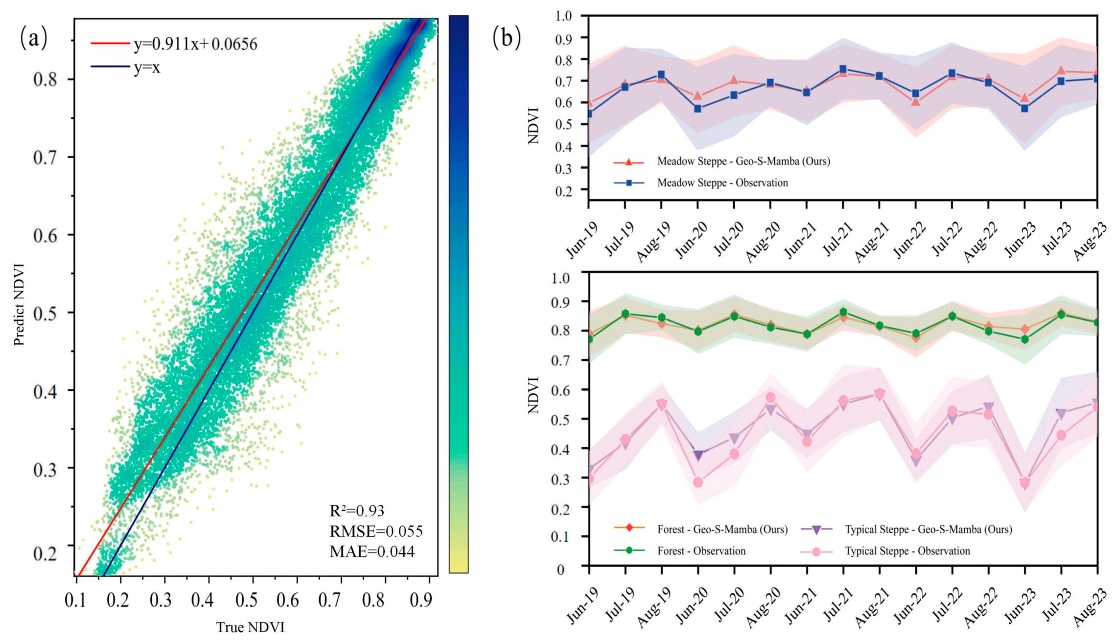
- The proposed Geo-S-Mamba framework accurately predicted monthly NDVI dynamics in the Hulunbuir Grassland, achieving high overall performance and improved spatial pattern consistency.
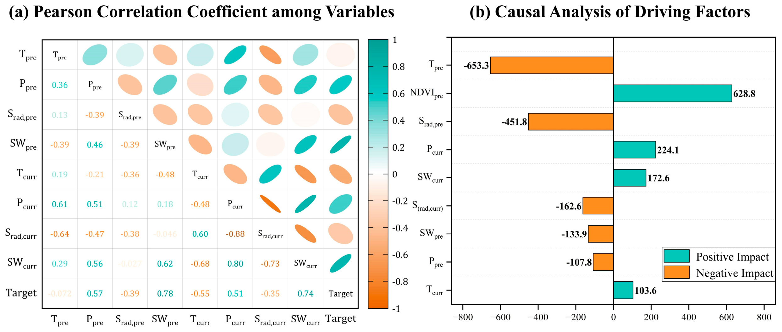
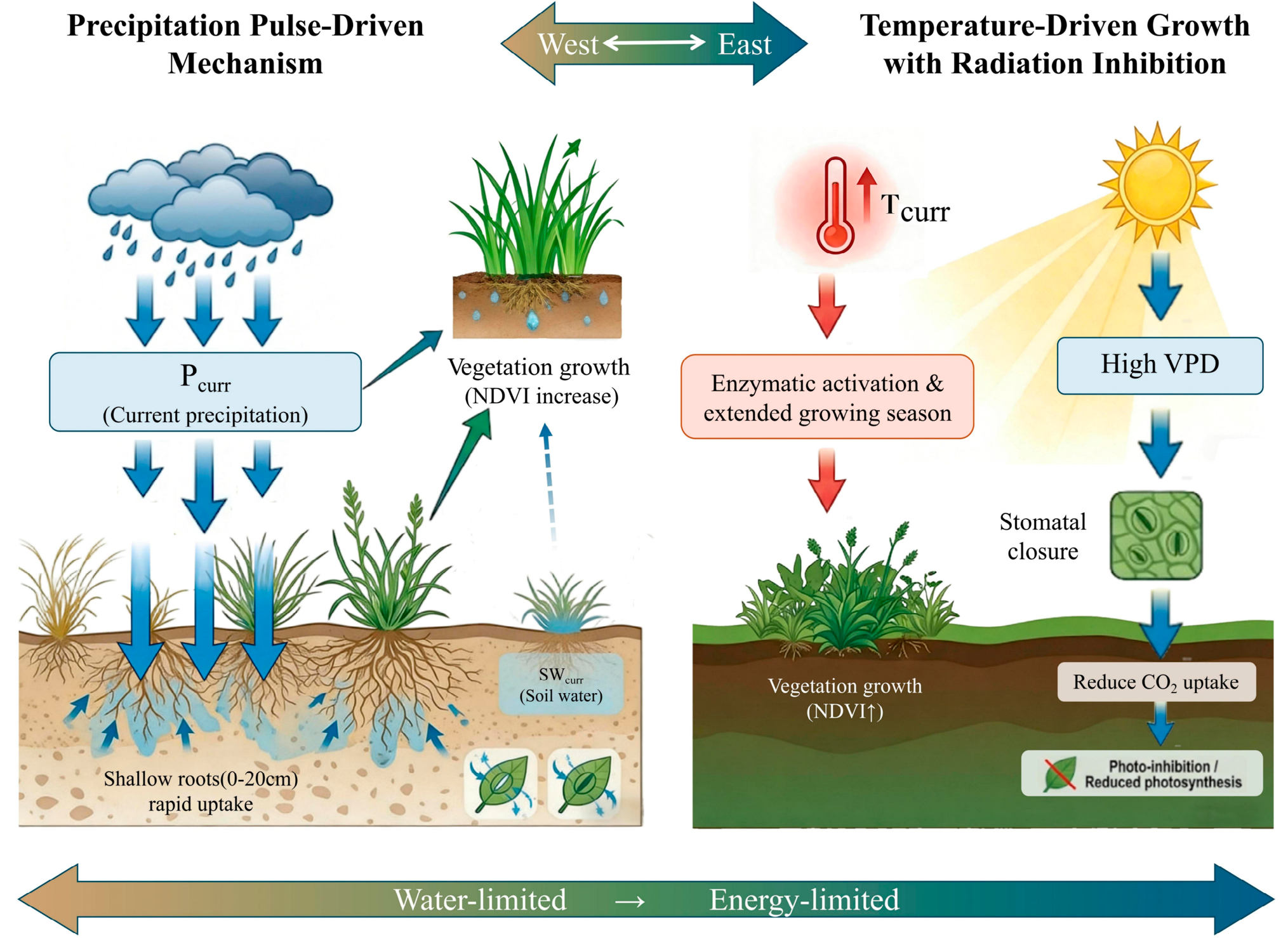
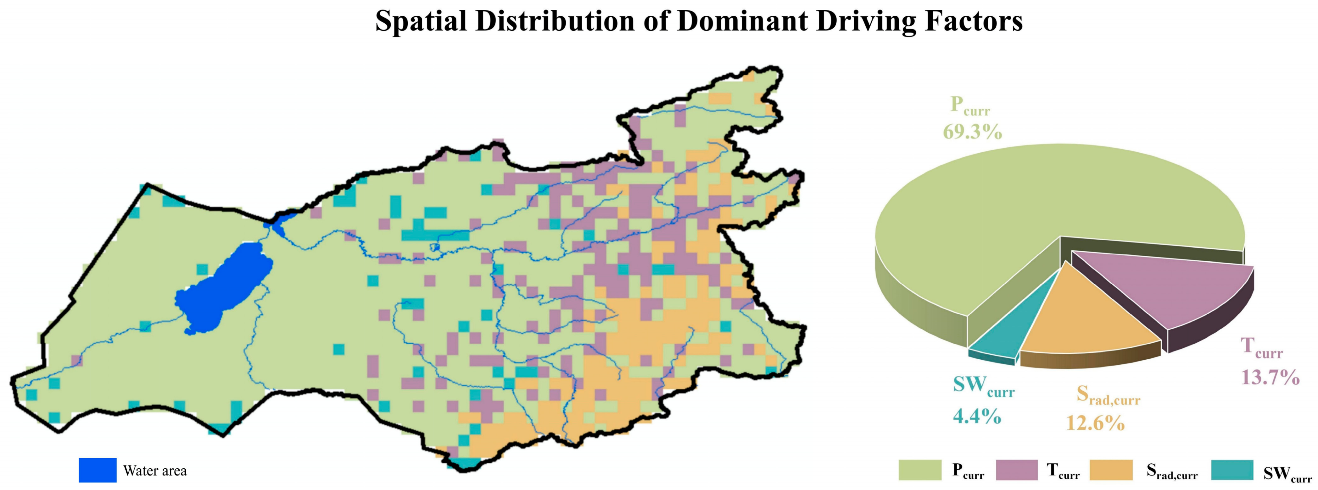
- Current moisture conditions, especially precipitation and soil moisture, were identified as key drivers of vegetation growth, while temperature promoted NDVI and strong shortwave radiation showed an inhibitory effect after controlling for confounding factors.
- Combining bidirectional Mamba modeling with spatial continuity constraints improves the reconstruction of heterogeneous grassland vegetation patterns and reduces fragmented prediction errors in complex ecotones.
- The interpretable causal framework helps move NDVI prediction beyond black-box modeling, providing useful evidence for grassland monitoring, climate-impact assessment, and adaptive ecosystem management in semi-arid regions.
Abstract
1. Introduction
2. Study Area and Data
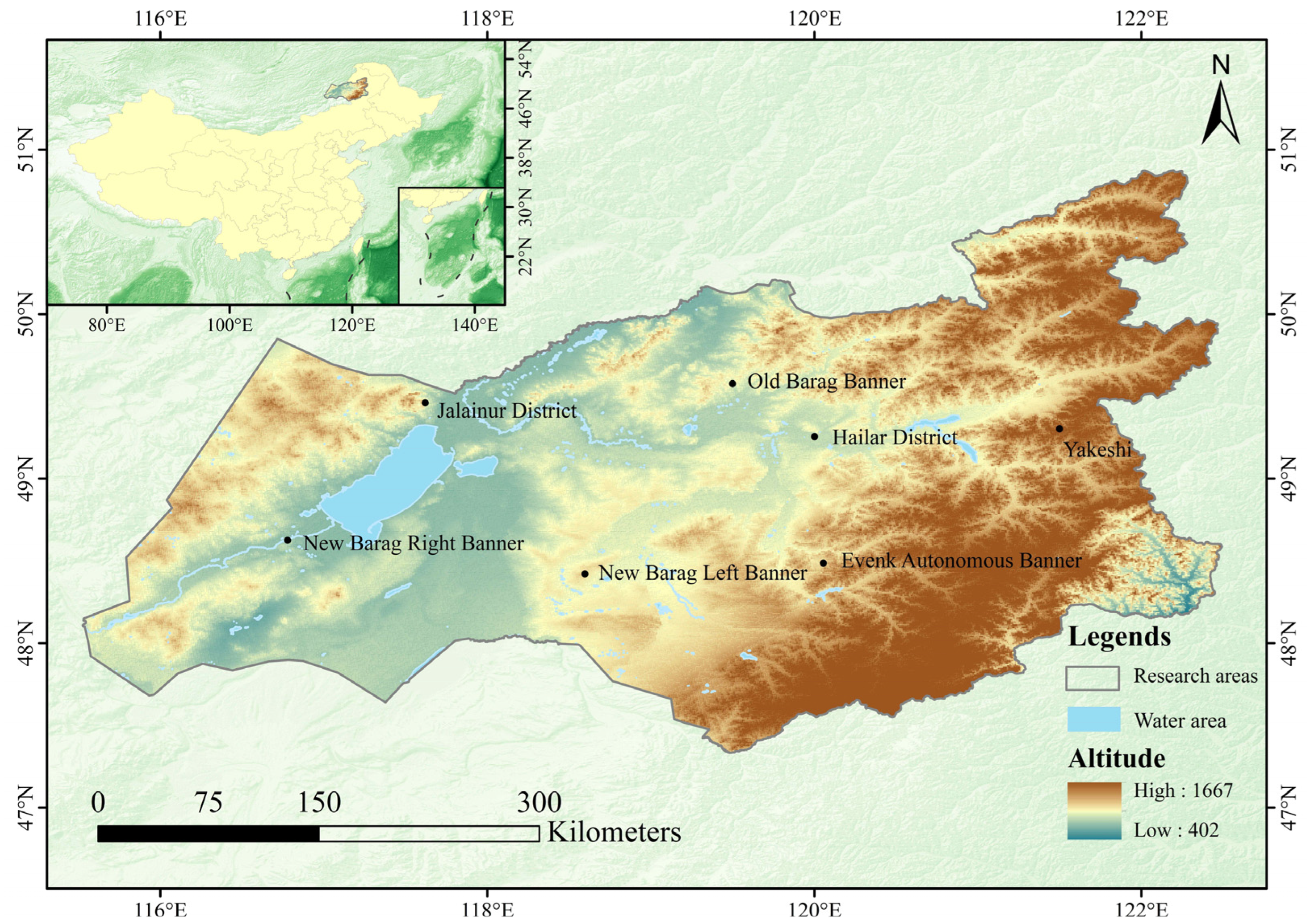
2.1. Overview of the Study Area
2.2. Dataset Construction
2.2.1. Vegetation Data
2.2.2. Meteorological Driving Data
2.2.3. Static Environmental Data
3. Methodology
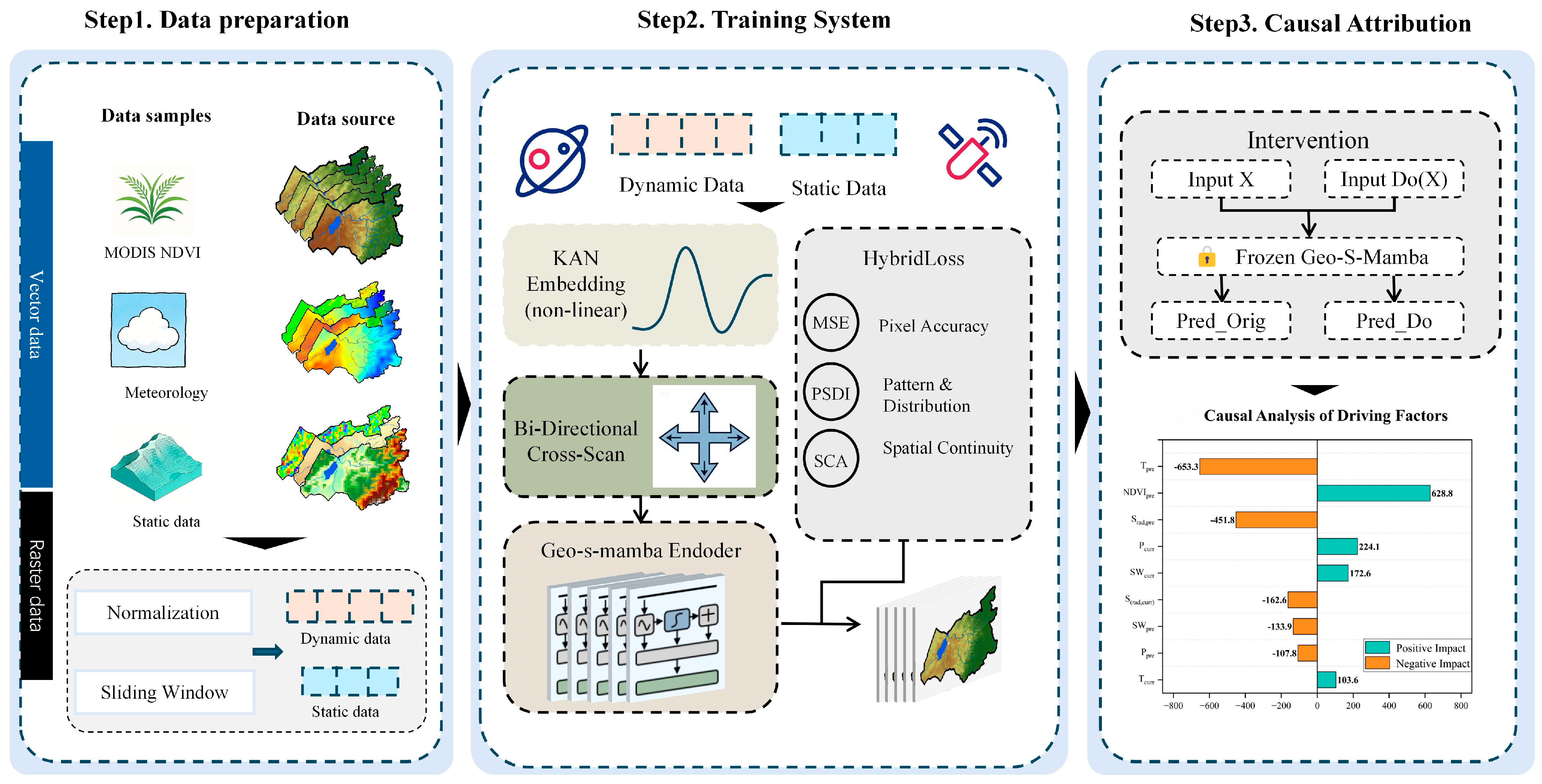
3.1. Overall Technical Roadmap
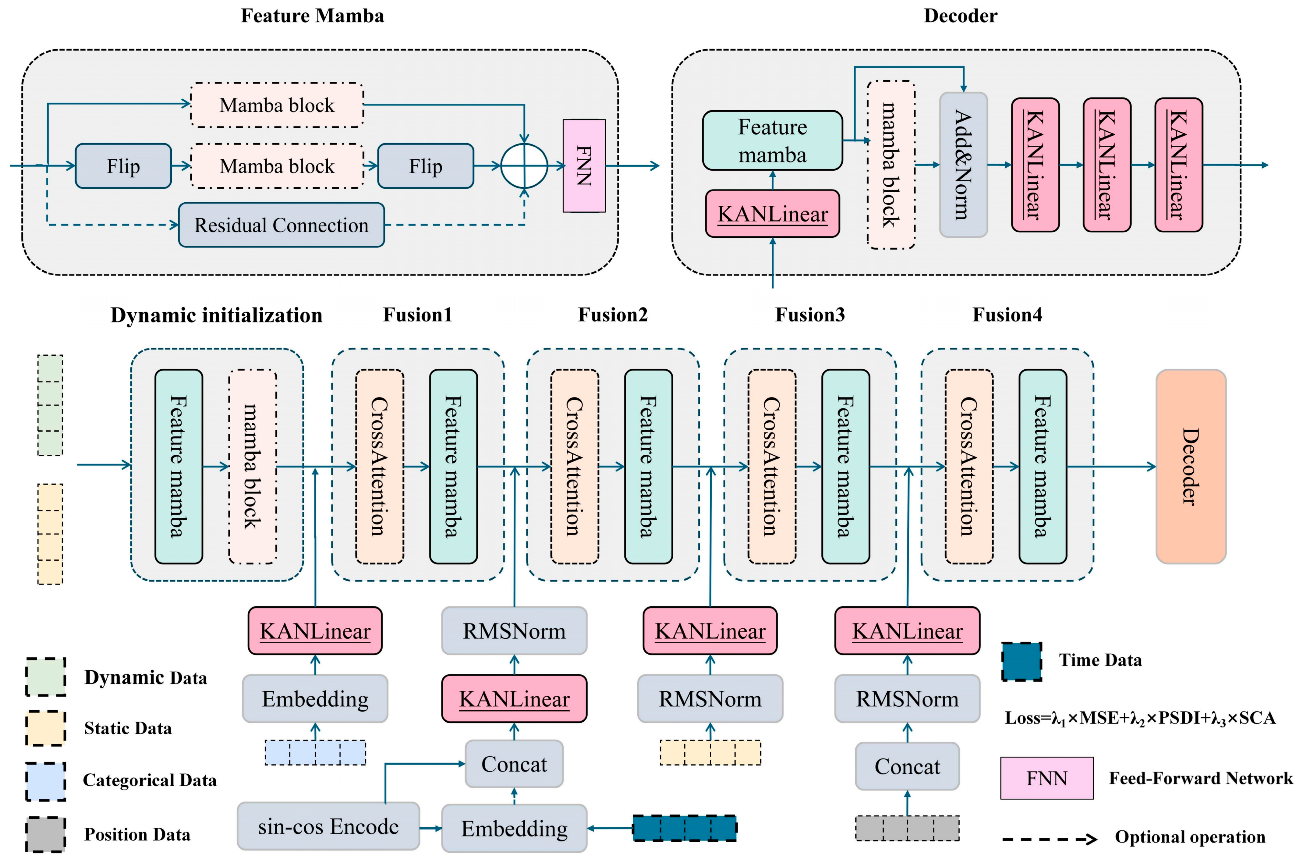
3.2. Bidirectional Geo-S-Mamba Model Architecture
- Nonlinear feature embedding based on KAN
- 2.
- Linear tokenization and state space equations
- 3.
- Bidirectional cross-scanning mechanism
3.3. Composite Spatial Loss Function Optimization
3.3.1. Pixel-Level Reconstruction Error ()
3.3.2. Predicted Spatial Difference Index ()
3.3.3. Spatial Autocorrelation Constraint ()
3.4. Intervention Analysis Based on Pearl Causal Graphs
4. Results
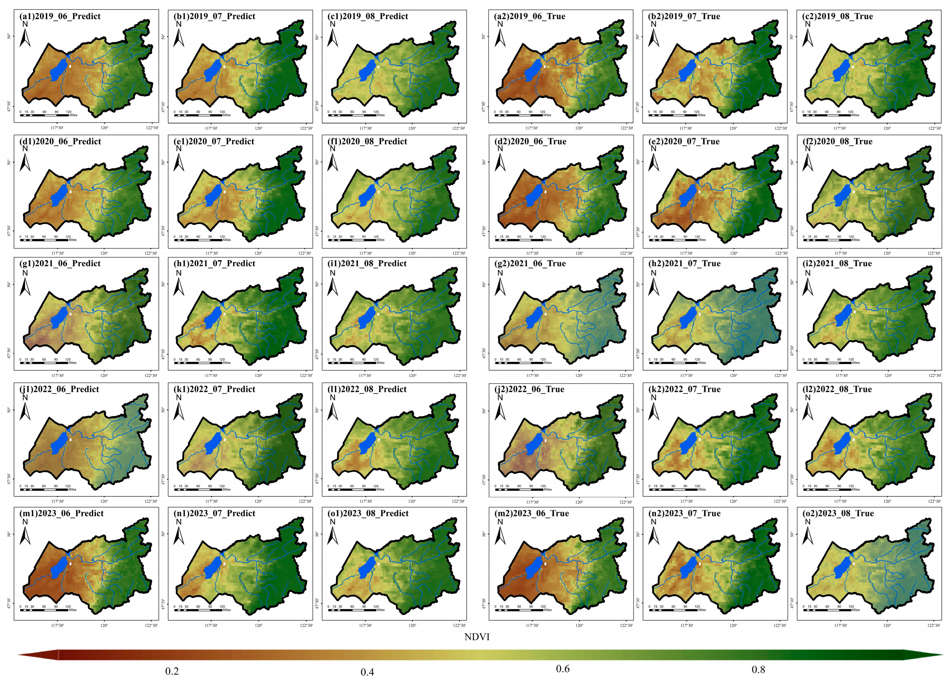
4.1. Evaluation of Spatiotemporal Prediction Performance
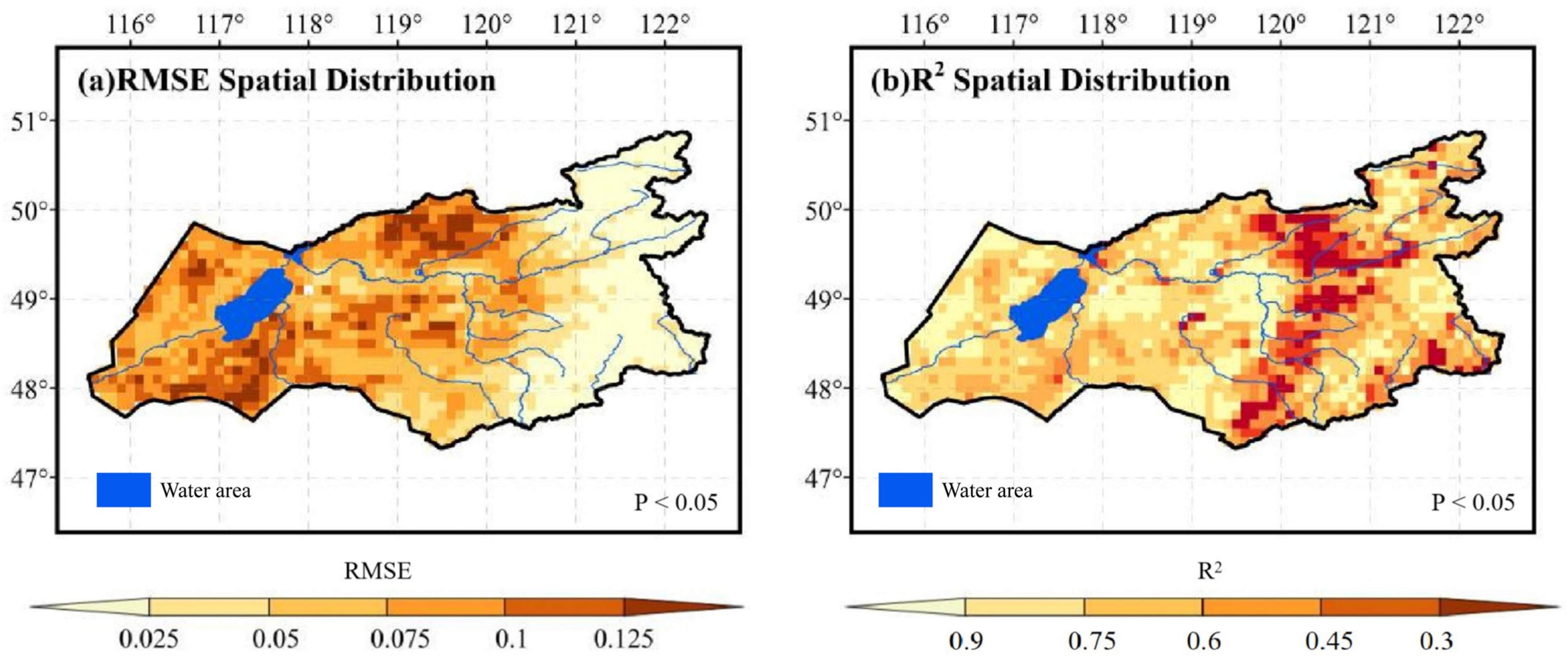
4.1.1. Overall Accuracy Performance
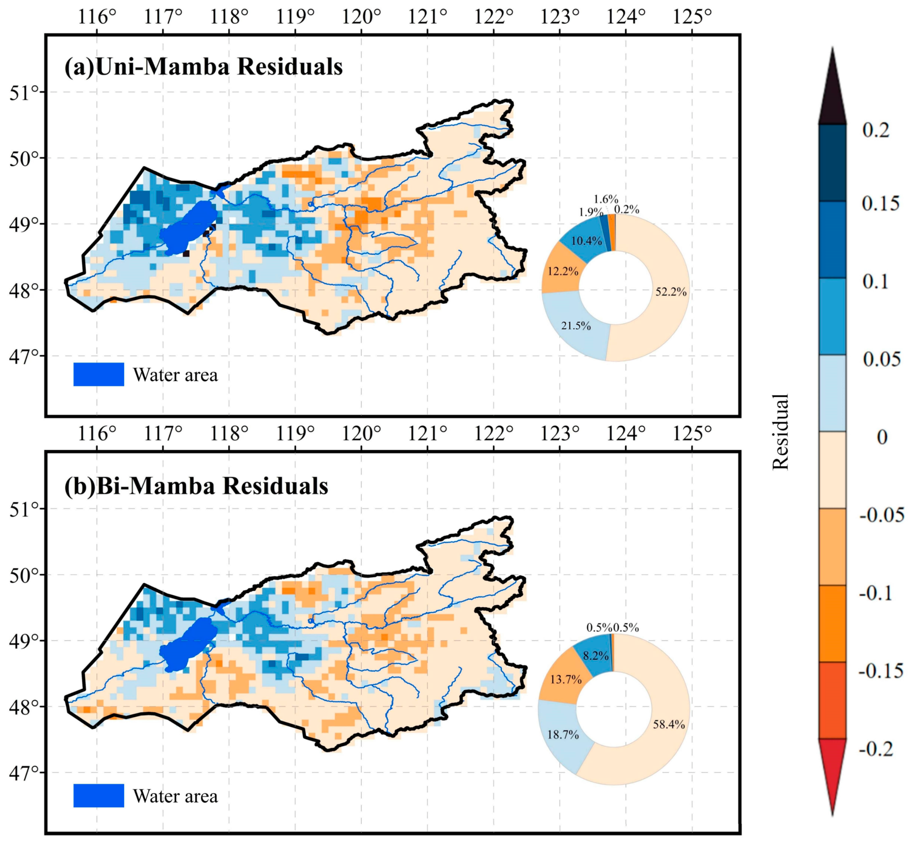
4.1.2. Contributions of the Bidirectional Mechanism and Composite Loss Function
4.2. Quantification of Causal Effects of Driving Factors and Spatial Patterns
5. Discussion
5.1. Spatial Differentiation of Climate Drivers and Ecological Interpretation
5.2. Geospatial Implications of Bidirectional Mamba
5.3. Limitations and Prospects
6. Conclusions
Supplementary Materials
Author Contributions
Funding
Data Availability Statement
Acknowledgments
Conflicts of Interest
Abbreviations
| NDVI | Normalized difference vegetation index |
| ARIMA | Autoregressive integrated moving average |
| LSTM | Long short-term memory |
| DEM | Digital Elevation Model |
| MVC | Maximum Value Composite |
| SCM | Structural causal model |
| CNNs | Traditional convolutional neural networks |
| SSM | State-space model |
| KAN | Kolmogorov–Arnold network |
| MAE | Mean absolute error |
| MSE | Mean squared error |
| PSDI | Predicted spatial difference index |
| RMSE | Root Mean Square Error |
| VPD | Vapour pressure deficit |
References
- Zhao, R.; Luo, X.; Walker, A.P.; Hoffman, F.M.; Koh, L.P. Vegetation biogeography is a main source of uncertainty in modelling the land carbon cycle. Nat. Commun. 2025, 17, 912. [Google Scholar] [CrossRef] [PubMed]
- Piao, S.; Wang, X.; Park, T.; Chen, C.; Lian, X.; He, Y.; Bjerke, J.W.; Chen, A.; Ciais, P.; Tømmervik, H.; et al. Characteristics, drivers and feedbacks of global greening. Nat. Rev. Earth Environ. 2020, 1, 14–27. [Google Scholar] [CrossRef]
- dos Santos, A.B.C.; Lamberti, P.P.; Oliveira, D.R.; Nogueira, M.L.; Alvarez, C.I.; da Costa, R.B. Global trends in vegetation carbon stock monitoring using Google Earth Engine and NDVI: A systematic review (2017–2024). Remote Sens. Appl. Soc. Environ. 2026, 41, 101863. [Google Scholar] [CrossRef]
- Álvarez-Martínez, J.M.; Lugonja, T.N.; Valdés, A.; Le Barbier, J.G.; Suárez, M.P.; Romero, G.H.; Radulović, M.; Knežević, M.; Tarčak, S.; Brkljač, B.; et al. Four decades of remote sensing for monitoring terrestrial ecosystems: A global review and future challenges. Sci. Remote Sens. 2026, 13, 100341. [Google Scholar] [CrossRef]
- Lu, Y.; Yu, Y.; Sun, L.; Li, C.; He, J.; Guo, Z.; Duan, L.; Zhang, J.; Yu, R. NDVI based vegetation dynamics and responses to climate change and human activities at Xinjiang from 2001 to 2020. Sci. Rep. 2025, 15, 25848. [Google Scholar] [CrossRef] [PubMed]
- Gorelick, N.; Hancher, M.; Dixon, M.; Ilyushchenko, S.; Thau, D.; Moore, R. Google Earth Engine: Planetary-scale geospatial analysis for everyone. Remote Sens. Environ. 2017, 202, 18–27. [Google Scholar] [CrossRef]
- Kowalski, K.; Senf, C.; Okujeni, A.; Hostert, P. Large-scale remote sensing analysis reveals an increasing coupling of grassland vitality to atmospheric water demand. Glob. Change Biol. 2024, 30, e17315. [Google Scholar] [CrossRef] [PubMed]
- Zhi, Q.; Hu, X.; Wang, P.; Li, M.; Ding, Y.; Wu, Y.; Peng, T.; Li, W.; Guan, X.; Shi, X.; et al. Estimation, Spatiotemporal Dynamics, and Driving Factors of Grassland Biomass Carbon Storage Based on Machine Learning Methods: A Case Study of the Hulunbuir Grassland. Remote Sens. 2024, 16, 3709. [Google Scholar] [CrossRef]
- Shan, N.; Wang, T.; Zhang, Q.; Gong, J.; He, M.; Zhang, X.; Lu, X.; Qiu, F. Monitoring Long-Term Vegetation Dynamics in the Hulun Lake Basin of Northeastern China Through Greening and Browning Speeds from 1982 to 2015. Plants 2025, 14, 3394. [Google Scholar] [CrossRef] [PubMed]
- Wu, Y.; Wang, P.; Hu, X.; Ding, Y.; Peng, T.; Zhi, Q.; Bademu, Q.; Li, W.; Guan, X.; Li, J. Evaluation of grassland degradation status and vegetation characteristics changes in Hulunbuir. Biodivers. Sci. 2025, 33, 24118. [Google Scholar] [CrossRef]
- Zhang, G.; Xu, X.; Zhou, C.; Zhang, H.; Ouyang, H. Responses of grassland vegetation to climatic variations on different temporal scales in Hulun Buir Grassland in the past 30 years. J. Geogr. Sci. 2011, 21, 634–650. [Google Scholar] [CrossRef]
- Mohanty, V.; Behera, D.K.; Panda, A.R.; Swetanisha, S. Comparative study of ARIMA and deep learning for NDVI forecasting using landsat 8 data. Indian J. Sci. Technol. 2025, 18, 922–936. [Google Scholar] [CrossRef]
- Aydin, I.; Sefercik, U.G. NDVI prediction with RGB UAV imagery utilizing advanced machine learning regression models. Int. Arch. Photogramm. Remote Sens. Spat. Inf. Sci. 2025, 48, 67–72. [Google Scholar] [CrossRef]
- Faran, I.; Netanyahu, N.S.; Shoshany, M. Spatio-Temporal Transformers for Long-Term NDVI Forecasting. arXiv 2026, arXiv:2602.01799. [Google Scholar] [CrossRef]
- Panuntun, I.A.; Jamaluddin, I.; Chen, Y.-N.; Lai, S.-N.; Fan, K.-C. LinkNet-spectral-spatial-temporal transformer based on few-shot learning for mangrove loss detection with small dataset. Remote Sens. 2024, 16, 1078. [Google Scholar] [CrossRef]
- Chen, Y.; Zhang, G.; Cui, H.; Li, X.; Hou, S.; Zhu, C.; Xie, Z.; Li, D. Super pixel-aware credible dual-expert learning for land cover mapping using historical land cover product. ISPRS J. Photogramm. Remote Sens. 2025, 223, 296–316. [Google Scholar] [CrossRef]
- Wang, Z.; Kong, F.; Feng, S.; Wang, M.; Yang, X.; Zhao, H.; Wang, D.; Zhang, Y. Is Mamba effective for time series forecasting? Neurocomputing 2025, 619, 129178. [Google Scholar] [CrossRef]
- Zhang, Q.; Zhang, X.; Quan, C.; Zhao, T.; Huo, W.; Huang, Y. Mamba-STFM: A Mamba-Based Spatiotemporal Fusion Method for Remote Sensing Images. Remote Sens. 2025, 17, 2135. [Google Scholar] [CrossRef]
- Runge, J.; Bathiany, S.; Bollt, E.; Camps-Valls, G.; Coumou, D.; Deyle, E.; Glymour, C.; Kretschmer, M.; Mahecha, M.D.; Muñoz-Marí, J.; et al. Inferring causation from time series in Earth system sciences. Nat. Commun. 2019, 10, 2553. [Google Scholar] [CrossRef] [PubMed]
- Bian, H.; Zhang, H.; Zhou, D.; Xu, J.; Zhang, Z. Integrating models to evaluate and map grassland fire risk zones in Hulunbuir of Inner Mongolia, China. Fire Saf. J. 2013, 61, 207–216. [Google Scholar] [CrossRef]
- Zhang, Y.; Kang, Y.; Guo, E.; Wang, Y.; Ma, H. Assessing the steppe vulnerability to extreme climate events in the Inner Mongolia. Ecol. Indic. 2025, 180, 114352. [Google Scholar] [CrossRef]
- Weng, C.; Bai, Y.; Chen, B.; Hu, Y.; Shu, J.; Chen, Q.; Wang, P. Assessing the vulnerability to climate change of a semi-arid pastoral social–ecological system: A case study in Hulunbuir, China. Ecol. Inform. 2023, 76, 102139. [Google Scholar] [CrossRef]
- You, G.; Liu, B.; Zou, C.; Li, H.; McKenzie, S.; He, Y.; Gao, J.; Jia, X.; Arain, M.A.; Wang, S.; et al. Sensitivity of vegetation dynamics to climate variability in a forest-steppe transition ecozone, north-eastern Inner Mongolia, China. Ecol. Indic. 2021, 120, 106833. [Google Scholar] [CrossRef]
- Huete, A.; Didan, K.; Miura, T.; Rodriguez, E.P.; Gao, X.; Ferreira, L.G. Overview of the radiometric and biophysical performance of the MODIS vegetation indices. Remote Sens. Environ. 2002, 83, 195–213. [Google Scholar] [CrossRef]
- Muñoz-Sabater, J.; Dutra, E.; Agustí-Panareda, A.; Albergel, C.; Arduini, G.; Balsamo, G.; Boussetta, S.; Choulga, M.; Harrigan, S.; Hersbach, H.; et al. ERA5-Land: A state-of-the-art global reanalysis dataset for land applications. Earth Syst. Sci. Data 2021, 13, 4349–4383. [Google Scholar] [CrossRef]
- Farr, T.G.; Rosen, P.A.; Caro, E.; Crippen, R.; Duren, R.; Hensley, S.; Kobrick, M.; Paller, M.; Rodriguez, E.; Roth, L.; et al. The Shuttle Radar Topography Mission. Rev. Geophys. 2007, 45, RG2004. [Google Scholar] [CrossRef]
- Liu, J.; Kuang, W.; Zhang, Z.; Xu, X.; Qin, Y.; Ning, J.; Zhou, W.; Zhang, S.; Li, R.; Yan, C.; et al. Spatiotemporal characteristics, patterns and causes of land use changes in China since the late 1980s. J. Geogr. Sci. 2014, 24, 195–210. [Google Scholar] [CrossRef]
- Camps-Valls, G.; Gerhardus, A.; Ninad, U.; Varando, G.; Martius, G.; Balaguer-Ballester, E.; Vinuesa, R.; Diaz, E.; Zanna, L.; Runge, J. Discovering causal relations and equations from data. Phys. Rep. 2023, 1044, 1–68. [Google Scholar] [CrossRef]
- Meng, X.; Yang, Y.; Wang, L.; Wang, T.; Li, R.; Zhang, C. Class-guided swin transformer for semantic segmentation of remote sensing imagery. IEEE Geosci. Remote Sens. Lett. 2022, 19, 6517505. [Google Scholar] [CrossRef]
- Gu, A.; Dao, T. Mamba: Linear-Time Sequence Modeling with Selective State Spaces. arXiv 2024, arXiv:2312.00752. [Google Scholar] [CrossRef]
- Liu, Z.; Wang, Y.; Vaidya, S.; Ruehle, F.; Halverson, J.; Soljačić, M.; Hou, T.Y.; Tegmark, M. KAN: Kolmogorov-Arnold networks. arXiv 2025, arXiv:2404.19756. [Google Scholar] [CrossRef]
- Longarela, B.; Conde, M.V.; Garcia, A.; Timofte, R. Efficient perceptual image super resolution: AIM 2025 study and benchmark. arXiv 2025, arXiv:2510.12765. [Google Scholar] [CrossRef]
- Shaowei, N.; Jie, W.; Juliang, J.; Xiaoyan, X.; Yuliang, Z.; Fan, S.; Linlin, Z. Comprehensive evaluation of satellite-derived precipitation products considering spatial distribution difference of daily precipitation over eastern China. J. Hydrol. Reg. Stud. 2022, 44, 101242. [Google Scholar] [CrossRef]
- Blau, Y.; Michaeli, T. The perception-distortion tradeoff. In Proceedings of the 2018 IEEE/CVF Conference on Computer Vision and Pattern Recognition, Salt Lake City, UT, USA, 18–23 June 2018; pp. 6228–6237. [Google Scholar] [CrossRef]
- Li, M.; Tong, S.; Yin, S.; Bao, Y.; Huang, X.; Alateng, T.; Wang, Y.; Guo, E.; Yuan, Z.; Nashun, D.; et al. Spatiotemporal variations of water use efficiency and its driving factors in Inner Mongolia from 2001 to 2020. J. Geogr. Sci. 2023, 33, 169–194. [Google Scholar] [CrossRef]
- Song, J.; Zhou, L.; Zhou, G.; Wang, Y.; Zhang, S.; Yan, Y. Hydrometeorological controls on net carbon dioxide exchange over a temperate desert steppe in Inner Mongolia, China. Front. Ecol. Evol. 2023, 11, 1169297. [Google Scholar] [CrossRef]
- Li, Z.; Jiao, Z.; Gao, G.; Guo, J.; Wang, C.; Chen, S.; Tan, Z.; Zhao, W. Improving global gross primary productivity estimation using two-leaf light use efficiency model by considering various environmental factors via machine learning. Sci. Total Environ. 2024, 954, 176673. [Google Scholar] [CrossRef] [PubMed]
- Lu, Q.; Liu, H.; Wei, L.; Zhong, Y.; Zhou, Z. Global prediction of gross primary productivity under future climate change. Sci. Total Environ. 2024, 912, 169239. [Google Scholar] [CrossRef] [PubMed]
- Spohn, M.; Arnillas, C.A.; Bakker, J.D.; Borer, E.T.; Bråthen, K.A.; Cadotte, M.W.; Carbutt, C.; Catford, J.A.; DuPre, M.E.; Dwyer, C.; et al. Intense solar radiation constrains plant species richness in global grasslands. Proc. Natl. Acad. Sci. USA 2026, 123, e2527128123. [Google Scholar] [CrossRef] [PubMed]
- Grossiord, C.; Buckley, T.N.; Cernusak, L.A.; Novick, K.A.; Poulter, B.; Siegwolf, R.T.W.; Sperry, J.S.; McDowell, N.G. Plant responses to rising vapor pressure deficit. New Phytol. 2020, 226, 1550–1566. [Google Scholar] [CrossRef] [PubMed]
- Chen, H.; Song, J.; Han, C.; Xia, J.; Yokoya, N. ChangeMamba: Remote Sensing Change Detection With Spatiotemporal State Space Model. IEEE Trans. Geosci. Remote Sens. 2024, 62, 4409720. [Google Scholar] [CrossRef]
- Bauer, P.; Thorpe, A.; Brunet, G. The quiet revolution of numerical weather prediction. Nature 2015, 525, 47–55. [Google Scholar] [CrossRef] [PubMed]
- Slater, L.J.; Arnal, L.; Boucher, M.-A.; Chang, A.Y.-Y.; Moulds, S.; Murphy, C.; Nearing, G.; Shalev, G.; Shen, C.; Speight, L.; et al. Hybrid forecasting: Blending climate predictions with AI models. Hydrol. Earth Syst. Sci. 2023, 27, 1865–1889. [Google Scholar] [CrossRef]
- Soltani, M.; Mahjouri, N.; Mahmoudian, S.A. A subseasonal-to-seasonal runoff forecasting framework under uncertainty: Application of numerical weather predictions and a Bayesian maximum entropy-based data fusion technique. J. Hydroinformatics 2025, 27, 1531–1553. [Google Scholar] [CrossRef]
- Reichstein, M.; Camps-Valls, G.; Stevens, B.; Jung, M.; Denzler, J.; Carvalhais, N.; Prabhat. Deep learning and process understanding for data-driven Earth system science. Nature 2019, 566, 195–204. [Google Scholar] [CrossRef] [PubMed]
- Karniadakis, G.E.; Kevrekidis, I.G.; Lu, L.; Perdikaris, P.; Wang, S.; Yang, L. Physics-informed machine learning. Nat. Rev. Phys. 2021, 3, 422–440. [Google Scholar] [CrossRef]
- Xi, X.; Zhuang, Q.; Liu, X. A Hybrid Physics-Guided Deep Learning Modeling Framework for Predicting Surface Soil Moisture. J. Geophys. Res. Mach. Learn. Comput. 2025, 2, e2025JH000682. [Google Scholar] [CrossRef]






| Variable Category | Variable ID | Indicator Name | Units | Data Source |
|---|---|---|---|---|
| Vegetation Data | NDVI | NDVI | / | https://www.earthdata.nasa.gov/data/catalog/lpcloud-mod13a3-006 (accessed on 1 October 2025) |
| Meteorological Driving Data | 2 m Temperature | T | K | https://cds.climate.copernicus.eu/datasets/reanalysis-era5-land (accessed on 1 October 2025) |
| Total Precipitation | P | m | ||
| Surface Net Solar Radiation | Srad | J·m−2 | ||
| Volumetric Soil Water Layer 1 | SW | m3·m−3 | ||
| Static Environmental Data | Elevation | dem | m | https://earthexplorer.usgs.gov/ (accessed on 12 October 2025) |
| Slope | Slope | ° | Calculated from DEM | |
| Aspect | Aspect | ° | Calculated from DEM | |
| Distance to Water Source | Distance | m | Derived from distance analysis in ArcGIS 10.8.2 | |
| Land Cover | LC | / | https://www.resdc.cn/ (accessed on 31 October 2025) |
| Model | Bi-Directional Module | Hybrid Loss | R2 | PSDI | RMSE | MAE | MSE |
|---|---|---|---|---|---|---|---|
| Baseline | - | - | 0.9193 | 0.8687 | 0.0581 | 0.0425 | 0.0034 |
| Baseline + Bi-directional Module | √ | - | 0.9271 | 0.8987 | 0.0752 | 0.0527 | 0.0057 |
| Baseline + Hybrid Loss | - | √ | 0.9051 | 0.9054 | 0.0630 | 0.0492 | 0.0040 |
| Geo-S-Mamba (Ours) | √ | √ | 0.9322 | 0.9425 | 0.0552 | 0.0441 | 0.0031 |
Disclaimer/Publisher’s Note: The statements, opinions and data contained in all publications are solely those of the individual author(s) and contributor(s) and not of MDPI and/or the editor(s). MDPI and/or the editor(s) disclaim responsibility for any injury to people or property resulting from any ideas, methods, instructions or products referred to in the content. |
© 2026 by the authors. Licensee MDPI, Basel, Switzerland. This article is an open access article distributed under the terms and conditions of the Creative Commons Attribution (CC BY) license.
Share and Cite
Huang, H.; Jiang, Y.; Xu, X.; Ouyang, X.; Guo, Z.; Ning, S.; Zhou, Y.; Luo, L.; Jin, J. Bridging Deep Learning and Ecological Interpretability: A Spatial Mamba Framework for NDVI Prediction in Forest-Steppe Ecotones Under Climate Variability. Remote Sens. 2026, 18, 2120. https://doi.org/10.3390/rs18132120
Huang H, Jiang Y, Xu X, Ouyang X, Guo Z, Ning S, Zhou Y, Luo L, Jin J. Bridging Deep Learning and Ecological Interpretability: A Spatial Mamba Framework for NDVI Prediction in Forest-Steppe Ecotones Under Climate Variability. Remote Sensing. 2026; 18(13):2120. https://doi.org/10.3390/rs18132120
Chicago/Turabian StyleHuang, Haoran, Yuhang Jiang, Xiaoyan Xu, Xinbai Ouyang, Zirui Guo, Shaowei Ning, Yuliang Zhou, Lei Luo, and Juliang Jin. 2026. "Bridging Deep Learning and Ecological Interpretability: A Spatial Mamba Framework for NDVI Prediction in Forest-Steppe Ecotones Under Climate Variability" Remote Sensing 18, no. 13: 2120. https://doi.org/10.3390/rs18132120
APA StyleHuang, H., Jiang, Y., Xu, X., Ouyang, X., Guo, Z., Ning, S., Zhou, Y., Luo, L., & Jin, J. (2026). Bridging Deep Learning and Ecological Interpretability: A Spatial Mamba Framework for NDVI Prediction in Forest-Steppe Ecotones Under Climate Variability. Remote Sensing, 18(13), 2120. https://doi.org/10.3390/rs18132120