Article

Segment-Scale Strain Accumulation and Seismic Potential of the Central North Anatolian Fault Zone with GNSS Constraints

by
Kayhan Aladoğan
1,
İbrahim Tiryakioğlu
2,3,
Cemil Gezgin
4,
Halil İbrahim Solak
3,5,
Hasan Hakan Yavaşoğlu
6 and
Vahap Engin Gülal
7,*
1
Osmancık Ömer Derindere Vocational School, Hitit University, 19030 Çorum, Türkiye
2
Department of Geomatics Engineering, Afyon Kocatepe University, 03200 Afyonkarahisar, Türkiye
3
Earthquake Implementation and Research Center, Afyon Kocatepe University, 03200 Afyonkarahisar, Türkiye
4
Department of Geomatics Engineering, Aksaray University, 68100 Aksaray, Türkiye
5
Distance Education Vocational School, Afyon Kocatepe University, 03200 Afyonkarahisar, Türkiye
6
Department of Geomatics Engineering, Istanbul Technical University, 34100 Istanbul, Türkiye
7
Department of Computer Engineering, Atlas University, 34408 Istanbul, Türkiye
*
Author to whom correspondence should be addressed.
Remote Sens. 2026, 18(13), 2070; https://doi.org/10.3390/rs18132070
Submission received: 23 May 2026 / Revised: 12 June 2026 / Accepted: 22 June 2026 / Published: 24 June 2026

Highlights

What are the main findings?
  • High-resolution GNSS-derived strain analysis reveals that deformation within the central North Anatolian Fault Zone is spatially partitioned among the main fault strand and multiple interacting splay fault systems rather than being localized along a single structure.
  • Geodetic earthquake recurrence modeling indicates strong segment-scale variability in seismic behavior, with the Merzifon–Esençay Fault, particularly the central segments, exhibiting elevated strain accumulation and a potential seismic magnitude reaching Mw 7.3–7.5.
What are the implications of the main findings?
  • The coexistence of long-term paleoseismological quiescence and high present-day strain accumulation along and around the Esençay segment suggests the presence of a candidate seismic gap within the central NAFZ.
  • The results demonstrate that segment-scale geodetic analyses integrated with paleoseismological and seismological observations provide critical constraints for regional seismic hazard assessment and complex multi-fault rupture evaluation in strike-slip fault systems.

Abstract

GNSS-derived strain-rate analysis, geodetic earthquake recurrence modeling, and seismic potential estimations were integrated to investigate segment-scale deformation behavior along the central North Anatolian Fault Zone (NAFZ) using a high-resolution geodetic velocity field. The obtained strain rates reveal that deformation within the central NAFZ is distributed across a geometrically complex and kinematically heterogeneous fault network rather than being restricted to the main fault strand alone. While the main fault accommodates the majority of regional deformation, significant strain accumulation is also observed along major splay fault systems, including the Merzifon–Esençay, Ezinepazarı, Sungurlu, Eldivan, and Ekinveren faults. The derived strain patterns further indicate the coexistence of localized transtensional and transpressional deformation regimes controlled by fault geometry, segment boundaries, and structural discontinuities. Geodetically derived earthquake recurrence periods display pronounced spatial variability, with shorter recurrence periods concentrated along the main fault strand and comparatively longer earthquake cycles characterizing structurally complex splay systems. Among the investigated structures, the eastern and central segments of the Merzifon–Esençay Fault (MEF) exhibit relatively elevated strain accumulation and seismic potential. In particular, the estimated potential earthquake magnitudes reaching Mw 7.3–7.5, together with paleoseismological evidence indicating that the most recent major surface-rupturing event along the Esençay segment occurred approximately 3700 years ago, suggest that this fault system may represent a candidate seismic gap within the central NAFZ. Overall, the results demonstrate that deformation within the central NAFZ is strongly partitioned among interacting fault segments and highlight the importance of segment-scale geodetic analyses for improving seismic hazard assessments in complex strike-slip fault systems.

1. Introduction

Monitoring and quantifying crustal deformation are fundamental for understanding the ongoing tectonic processes that shape the Earth’s surface and govern seismic hazard. In this context, geodetic observations provide robust quantitative constraints on the mechanisms of tectonic strain accumulation within the Earth’s crust, as well as on the spatial and temporal evolution of surface deformation. At the crustal scale, these deformation patterns are closely associated with the accumulation and release of elastic strain along active fault systems during the seismic cycle. According to the elastic rebound theory proposed by [1], elastic strain energy accumulates along fault zones during the interseismic period and is released once a critical stress threshold is exceeded, generating earthquakes.
In recent decades, significant advances in space geodesy have enabled the precise monitoring of crustal deformation associated with active tectonics and the earthquake cycle. In particular, GNSS-based observations allow deformation patterns to be resolved with high accuracy, providing critical insights into fault kinematics and tectonic block motions. These geodetic datasets play a critical role in identifying the spatial distribution of strain accumulation and stress transfer within a region. As a result, they provide essential constraints for detecting active or potentially active seismic sources. Beyond characterizing the behavior of known faults, geodetic observations also contribute to the identification of regions with elevated seismic hazard potential and provide a scientific basis for evaluating possible earthquake scenarios. Such studies have been widely conducted in tectonically active regions worldwide, including Anatolia, Türkiye [2,3,4,5,6]; the Canary Islands, Spain [7]; North America, USA [8]; Sinai Peninsula, Egypt [9]; and across Asia [10,11]. Accordingly, geodetic observations play a fundamental role in deciphering the kinematic behavior of complex fault systems where deformation is distributed across multiple interacting tectonic structures.
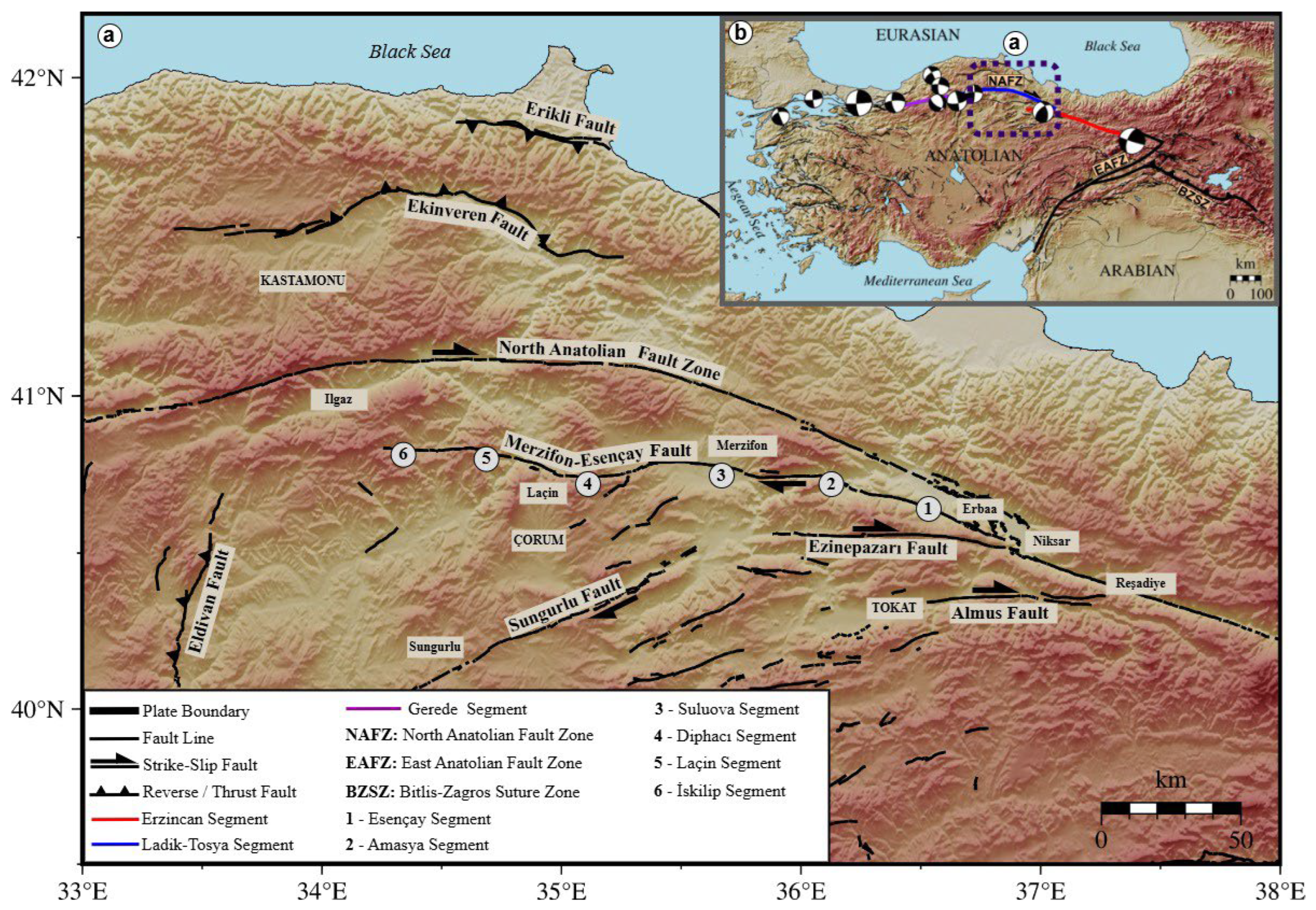
The NAFZ is one of the world’s major continental strike-slip fault systems and is characterized by high deformation rates and a well-documented history of destructive earthquakes [12]. The NAFZ forms the northern tectonic boundary of the Anatolian Plate, playing a major role in accommodating the regional deformation associated with the ongoing convergence between the Arabian and Eurasian plates. The NAFZ is recognized as one of the most active seismic belts in Eurasia and has generated numerous destructive earthquakes throughout the historical and instrumental periods. During the twentieth century alone, the fault system produced six major earthquakes with M > 7.0 over an interval of nearly six decades, reflecting its high seismic potential and complex segmented structure [13,14,15]. The study area considered in this study corresponds to the central part of the NAFZ and is bounded by the Black Sea coastal belt to the north, Kastamonu–Ilgaz to the west, Yozgat to the south, and Tokat–Niksar to the east (Figure 1). This region includes the rupture zones of the 1942 Niksar–Erbaa (M = 7.0) and 1943 Tosya–Ladik (M = 7.2) earthquakes and represents one of the most tectonically significant and structurally complex segments of the fault system.
Findings from the limited number of paleoseismological investigations conducted in the region, which is characterized by numerous north- and south-oriented intraplate splay faults, further support its structurally complex nature. In particular, studies on the Esençay Segment (Figure 1a) indicate that at least two major surface-rupturing earthquakes occurred during the last ~7000 years with recurrence periods ranging between 1320 and 2200 years. These findings further suggest the accumulation of sufficient elastic strain to generate meter-scale surface rupture along the segment and may indicate the presence of a candidate seismic gap, given that the most recent major earthquake is estimated to have occurred approximately 3700 years ago [18]. Similarly, trench-based paleoseismological studies conducted along the Ezinepazarı Fault have revealed evidence for both historical and prehistoric earthquake events [19,20]. Nevertheless, paleoseismological constraints on the splay faults within the central NAFZ remain limited to these two fault systems, while the present-day strain accumulation along both the main fault and associated subsidiary structures is still poorly constrained, particularly at the scale of individual splay faults and segments. Therefore, this limitation directly affects the physical interpretation of fault interactions, as unresolved deformation may be incorrectly attributed to the master fault, thereby masking the contribution of secondary structures. In addition to geological investigations, previous GNSS-based studies have predominantly focused on the master fault and are commonly limited by insufficient station density, resulting in low spatial resolution and reduced reliability of strain components derived from velocity field gradients [21,22]. As a consequence, the spatial variability of strain accumulation at the scale of individual fault segments remains fundamentally unresolved. Accordingly, the distribution of deformation between the main fault strand and associated splay faults has not yet been clearly quantified, and the earthquake recurrence behavior together with the present-day strain accumulation along several segments of both the principal fault and subsidiary structures still remain largely uncertain, thereby limiting reliable assessments of segment-scale seismic hazard in a region hosting numerous densely populated urban centers like Amasya, Tokat, Çorum, and Samsun (Figure 1b).
In this study, we address this critical gap by resolving strain accumulation at the segment scale across both the main fault and associated splay fault systems using a high-resolution GNSS-derived velocity field integrated with strain-rate analysis, geodetic earthquake recurrence modeling, and potential magnitude estimation. Unlike previous studies that primarily focused on the main fault or were constrained by limited spatial resolution, our approach quantifies the spatial partitioning of deformation across previously unresolved subsidiary fault structures. The integration of geodetic, paleoseismological, and seismological constraints further enables a comprehensive assessment of earthquake recurrence behavior and seismic potential. In particular, segment-scale deformation analysis provides new insights into the spatial heterogeneity of strain accumulation and fault interactions, which are critical for understanding seismic segmentation and rupture propagation within complex multi-fault systems. Overall, the results establish a unified framework linking strain accumulation, fault interaction, and earthquake recurrence behavior, thereby providing improved constraints for seismic hazard assessment along the central NAFZ.

2. Tectonic and Seismotectonic Framework of the Central NAFZ

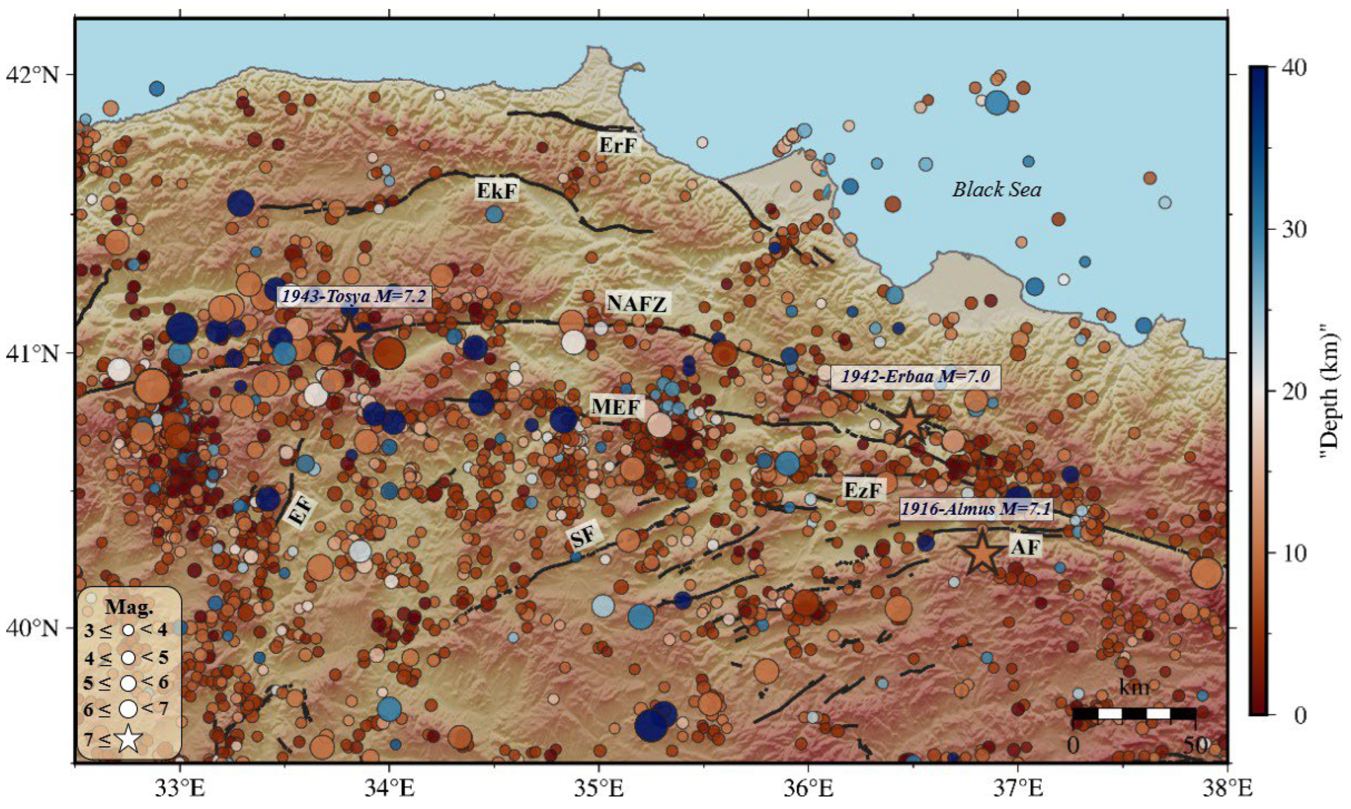
The NAFZ is a right-lateral continental strike-slip fault system that developed in response to the ongoing convergence between the Arabian and Eurasian plates and the westward motion of the Anatolian Plate [23]. This tectonic interaction has forced the Anatolian Plate to move westward, and the resulting deformation is largely accommodated along the NAFZ in the form of strike-slip motion. Extending approximately 1200 km, the fault zone originates from the Karlıova triple junction in the east and continues westward to the Aegean Sea, forming a prominent deformation belt along northern Anatolia [14,15]. The NAFZ is widely recognized as one of the most active seismic belts due to the destructive earthquakes it has generated during both historical and instrumental periods (Figure 2). Earthquake sequences migrating from east to west since the mid-20th century demonstrate that the fault zone ruptures in a segmented manner. Major earthquakes such as the 1939 Erzincan (M = 7.9), 1942 Niksar–Erbaa (M = 7.0), 1943 Tosya–Ladik (M = 7.2), 1944 Bolu–Gerede (M = 7.4), and the 1999 İzmit (M = 7.4) and Düzce (M = 7.1) events form a westward-propagating rupture sequence, highlighting the kinematic continuity of the fault system [12,13]. Analysis of these earthquakes and their associated surface ruptures reveals that the NAFZ is primarily composed of major segments including Erzincan, Ladik–Tosya, and Gerede, from east to west, respectively [24,25,26].
In addition to these major ruptures, instrumental seismicity reveals persistent moderate-magnitude earthquake activity not only along the main fault but also across associated splay structures, indicating that active deformation and seismicity are continuously distributed throughout the broader fault network. In the central part of the fault zone, deformation becomes increasingly complex. The fault system broadens into a semi-parallel structure forming a distributed deformation zone [18,20]. At the crustal scale, this geometry is associated with a positive flower structure composed of both low- and high-angle faults [28]. In the Niksar–Reşadiye region, deformation is controlled not only by the main fault but also by several splay faults, including the Almus, Ezinepazarı–Sungurlu (EzSF), Merzifon–Esençay (MEF), and Ekinveren (EkF) faults [16,29,30]. These structures lead to a heterogeneous distribution of slip and contribute to the widening of the deformation zone. This structural complexity is directly reflected in the kinematic behavior of individual splay faults, which play an active role in accommodating regional deformation [18,31].
The role of these secondary fault systems is further emphasized by their kinematic and seismic behavior. EkF is a north-dipping, E–W striking thrust fault composed of multiple en échelon segments along the northern margin of the Kastamonu Basin, forming the southern boundary of the Sinop Range [30]. It is interpreted as an inverted normal fault that originally developed during Late Cretaceous rifting and was later reactivated as a thrust after ~11 Ma in response to transpressional deformation associated with the restraining bend of the NAFZ [32]. This tectonic evolution has resulted in uplift and deformation of the surrounding region, with geomorphological evidence such as river deflections and deformed Quaternary surfaces indicating ongoing activity [30,33].
The EzSF extends approximately 250 km and forms a multi-segmented system [12,18,34,35]. Paleoseismological evidence indicates multiple large surface-rupturing earthquakes prior to 1939, with recurrence intervals of 900–1200 years [18,25]. GNSS-based observations suggest a right-lateral slip rate of ~2 mm/yr, indicating that this fault accommodates part of the regional strain and may rupture in conjunction with the main fault. These characteristics indicate that the EzSF is not a passive secondary structure but an active component of the regional deformation system, capable of participating in strain accumulation and seismic release [36,37].
Similarly, the MEF extends approximately 227 km and consists of multiple segments controlling regional basin development [18,38,39]. Geodetic and paleoseismological data indicate right-lateral motion with slip rates of ~2 mm/yr and recurrence intervals between 1300 and 2200 years. The presence of meter-scale displacements suggests that this fault has the potential to generate large earthquakes through interaction with the main fault system. The MEF is divided into six segments, namely the Esençay, Amasya, Suluova, Diphacı, Laçin, and İskilip segments, which are separated by releasing and restraining step-overs and bends. These segments range in length from approximately 31 to 61 km, reflecting along-strike variations in fault geometry [16,18]. These variations indicate that deformation is heterogeneously distributed along the fault and may influence rupture segmentation and propagation, highlighting the role of the MEF in deformation partitioning and potential multi-fault rupture scenarios within the central NAFZ [18,40].
Geodetic observations indicate that slip rates along the central NAFZ increase from east to west, ranging from approximately 18 mm/yr to 22 mm/yr [17,36,37]. This geodetic pattern is also supported by geomorphological and seismological evidence. Linear valleys, offset stream channels, and fault scarps indicate ongoing tectonic activity, while recorded moderate-magnitude earthquakes confirm the present-day activity of splay faults. Observed offsets of up to ~1 km further indicate long-term slip accumulation. These geomorphic indicators, when considered together with geodetic observations, provide consistent evidence for ongoing deformation and strain accumulation across both the main fault and associated splay fault systems [40,41]. Taken together, these observations demonstrate that the central NAFZ represents a structurally complex and highly heterogeneous tectonic system in which deformation is not confined to the master fault but is systematically partitioned across multiple fault strands [12,21,42,43,44]. Consequently, the heterogeneous distribution of deformation across the central NAFZ necessitates high-resolution investigations of segment-scale strain accumulation and its implications for fault interaction and regional seismic hazard.

3. Methodology and Models

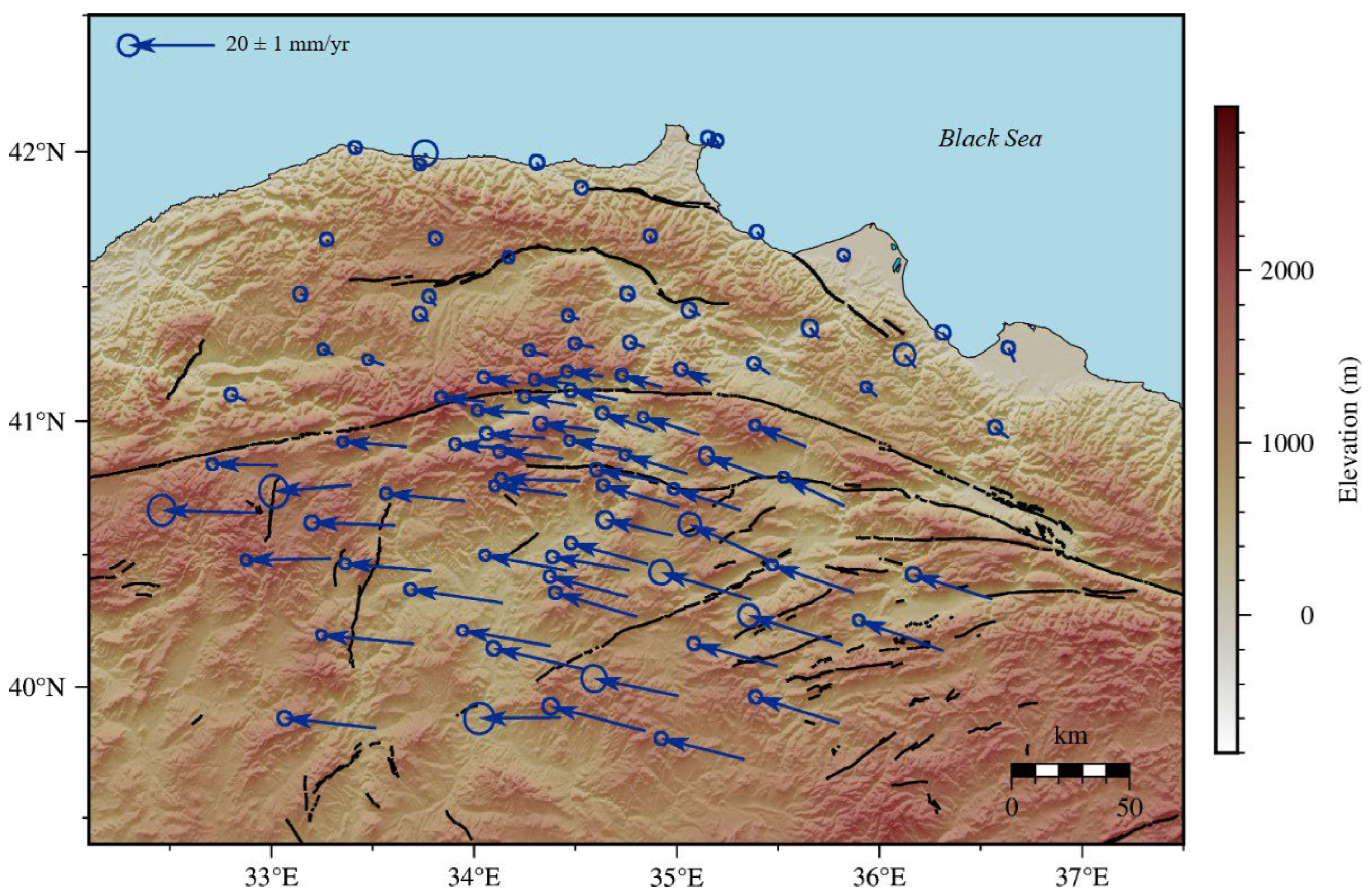
A high-resolution GNSS-derived velocity field was employed in this study to constrain the spatial distribution and partitioning of strain accumulation, segment-scale deformation variability, earthquake recurrence characteristics and seismic potential across both the main fault and associated splay fault systems within the central NAFZ. For this purpose, the most recent Eurasia-fixed velocity field presented by [37] was adopted as the primary geodetic dataset, consisting of 105 GNSS stations including continuously operating TUSAGA-Active sites and campaign-style observation sites distributed throughout the study area (Figure 3). The velocity solutions are defined in the Eurasia-fixed ITRF2014 reference frame and are based on long-term observations spanning the period between 2000 and 2024. Velocity uncertainties were evaluated considering both white and temporally correlated noise components, thereby ensuring realistic error propagation in subsequent strain analyses. To minimize potential biases and ensure robustness, GNSS sites with velocity uncertainties greater than 3 mm/yr were excluded from the analysis. Therefore, to improve the robustness of the dataset, eight GNSS sites (AKD1, BOYT, CAL1, GBAG, IKIP, INBO, KVAK, SINO) exhibiting irregular time-series behavior or localized deformation effects were excluded from further analyses. The resulting geodetic dataset provides a spatially consistent and well-constrained basis for resolving crustal deformation patterns within the central NAFZ.

3.1. Principal Strain Rates

Strain represents the unit deformation within the Earth’s crust resulting from the combined effects of internal and external forces, including displacement, rotation, stress, and shape alterations [45]. Temporal variations in GNSS-derived site positions enable the determination of the spatial distribution of strain at regional scales. In fault zone settings, strain analysis constitutes a fundamental tool for understanding the temporal and spatial characteristics of ongoing deformation [46]. In particular, elastic strain accumulation along active faults provides critical constraints for identifying potential seismic sources [47,48,49,50].
Therefore, in this study, the methodological approach developed by [51] and subsequently refined by [52] was adopted to estimate strain rates from the GNSS velocity field that was mentioned above, as it has been widely demonstrated to provide robust and reliable strain-rate estimates. Within this framework, strain rates, rotational components, and translational parameters at predefined grid nodes were simultaneously estimated using a least-squares approach. The uncertainties of the estimated strain parameters were derived from the covariance matrix of the least-squares inversion, which incorporates both GNSS velocity uncertainties and spatial weighting functions. This approach allows for the propagation of observational errors into the strain field and provides a quantitative assessment of the reliability of the derived deformation patterns.
Accordingly, covariance matrix ( C i j ) of the GNSS velocities was weighted to account for both the spatial distances between observation stations and estimation points, as well as the uncertainties associated with the velocity measurements [51];
C i j = Q i j e x p ( r x i 2 + r y j 2 σ D 2 )
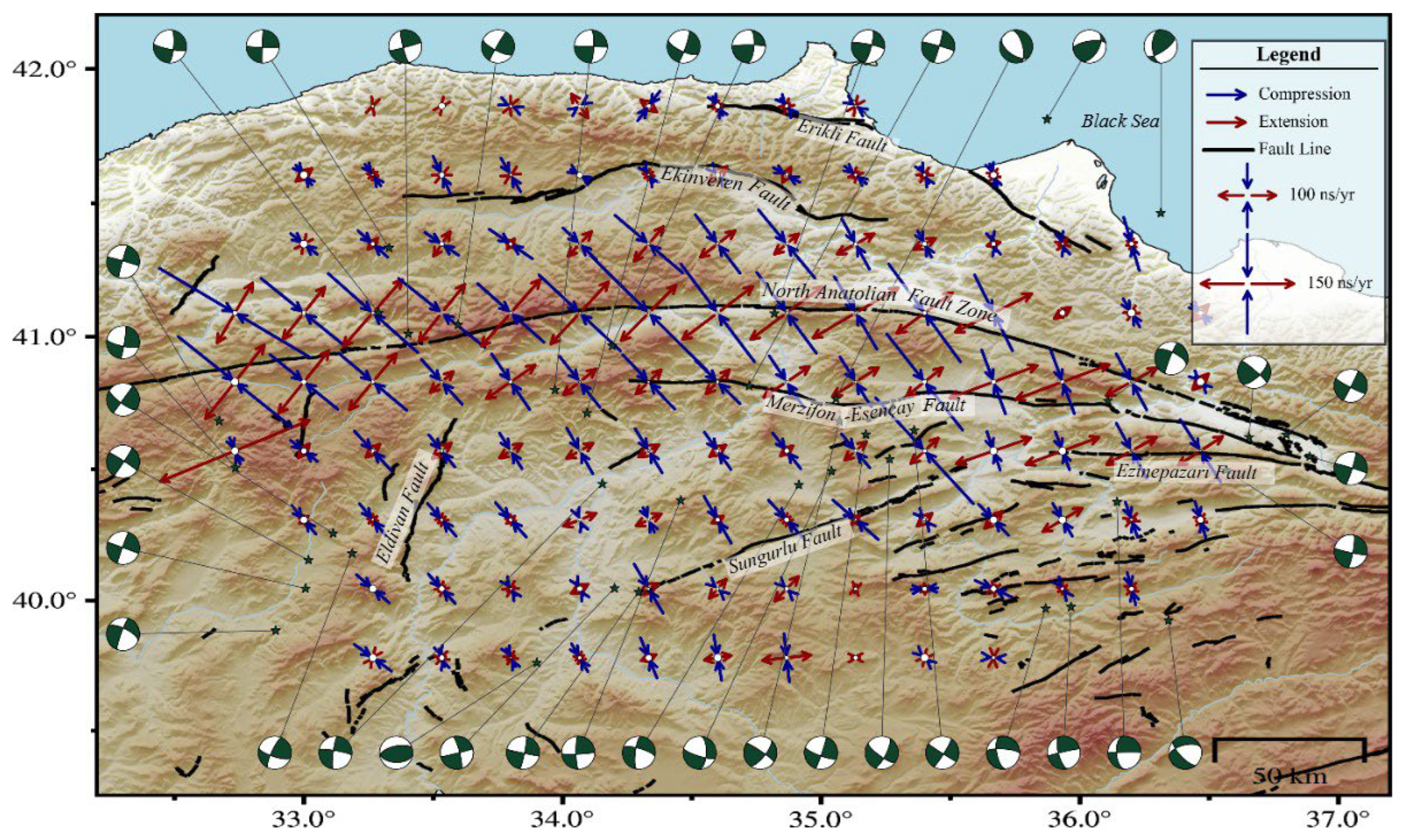
Within this formulation, position vectors represent the distances between observation sites and the center of each grid cell in the x and y directions. The smoothing parameter (σD) acts as a spatial filter, controlling the contribution of neighboring stations to the estimation of strain parameters at each grid node [52]. In addition, GeodSuit (Ankara, Türkiye) applies an azimuthal coverage criterion to avoid estimating strain parameters at locations characterized by poor station geometry. The iterative procedure implemented in GeodSuit yielded an optimum smoothing parameter of σD = 50 km based on the geometry and spatial distribution of the GNSS network. This value represents a compromise between preserving localized deformation signals and suppressing short-wavelength noise and has been widely employed in subsequent strain-rate investigations [5,53,54,55]. Smaller σD values increase spatial resolution but amplify noise, whereas larger values produce smoother strain fields at the expense of local detail. With this selection, a station located approximately 25 km from a grid node contributes nearly 80% to the estimation of the strain rate at that location [56]. Within this regard, principal strain rates across the study area were computed within a two-dimensional framework using GeodSuit v3.5 on a regular grid with a spatial resolution of 0.25° × 0.25° (Figure 4).

3.2. Seismic Moment and Earthquake Recurrence Estimation

Earthquake recurrence is fundamentally governed by the cyclic process of elastic strain accumulation and release along active fault systems [1]. Characterizing this seismic cycle is essential for understanding the temporal behavior of large earthquakes and improving regional seismic hazard assessments. In this context, long-term paleoseismological records, instrumental earthquake catalogs, and present-day geodetic observations provide complementary constraints on fault activity and recurrence behavior [57]. Among these approaches, GNSS-derived strain rates offer a particularly valuable framework by directly quantifying ongoing crustal deformation and stress accumulation within the interseismic period [58,59].
Strain rates, which quantify stress accumulation along active fault zones, provide a complementary framework for paleoseismological investigations. The integration of these datasets allows for improved estimation of earthquake recurrence periods and the timing of potential ruptures. While paleoseismological studies directly constrain recurrence periods through surface-rupturing events, exceedance of these intervals is generally interpreted as an indicator of elevated seismic hazard [60]. However, probabilistic models based solely on instrumental earthquake catalogs remain limited, particularly in regions characterized by long recurrence intervals or incomplete historical/instrumental period records. In contrast, GNSS-derived strain rates provide continuous observations of crustal deformation independent of such limitations. Accordingly, geodetic analyses offer a robust framework for constraining earthquake recurrence behavior when integrated with paleoseismic and seismological data. In GNSS-based recurrence estimations, the Gutenberg–Richter parameters (a and b) were used to describe the statistical distribution of earthquake occurrence. The parameter a represents the overall level of seismic activity, whereas the b-value reflects the relative proportion of small and large earthquakes [61,62]. The annual occurrence rate of earthquakes with magnitude M (M < Mmax) is expressed as:
N(M) = (10)a+bM (M < Mmax)
where N(M) denotes the rate of the events in a time period, a and b values are the seismic parameters. Here, the a-value reflects the overall level of seismic activity within the region, whereas the b-value represents the relative proportion of small to large earthquakes and is also closely related to the regional stress distribution [63]. In this study, previously published studies along the NAFZ based on the KOERI earthquake catalog were used to constrain these parameters, and the derived values were directly incorporated into subsequent calculations (Equations (3) and (4)). The recurrence period formulation was further extended by incorporating geodetic strain parameters following the approaches of [64,65]. Accordingly, the average recurrence interval for earthquakes with magnitudes greater than or equal to M was initially expressed using the classical frequency–magnitude relationship given in Equation (3). Subsequently, following the framework proposed by [66], geodetically derived moment rates were incorporated into the recurrence calculations in place of seismic moment rates, allowing earthquake recurrence intervals to be reformulated as presented in Equation (4).
T ( M ) = 1 10 a M M m a x 10 b M d M
T M = b ( 1.5 + b ) 10 1.5 + b M w + 9.105 2 μ H s e i s m o g e n i c ε m a x ( 10 b M m a x 10 b M w )
In Equation (4), seismogenic thickness was assumed as Hseismogenic = 15 km, and the shear modulus was taken as μ = 30 GPa, consistent with commonly adopted values in regional geodetic and seismological studies. For the b-value previously published studies along the central segment of the NAFZ exhibit spatial variability. Along the main strand of the NAFZ, particularly within the Amasya–Tokat corridor including the Merzifon–Esençay segment, reported b-values generally range between b ≈ 0.8 and 1.2 [67]. For secondary fault structures, relatively higher and more variable b-values have been reported. The Ezinepazarı Fault is characterized by b-values in the range of approximately 0.9–1.2, whereas the Sungurlu Fault exhibits higher values between b ≈ 1.1 and 1.4 [22,68]. Based on these calculations, representative average b-values were assigned for each fault segment for use in recurrence calculations. Accordingly, a value of b ≈ 1.0 was adopted for the main NAFZ strand, the Merzifon–Esençay Fault, and the Ezinepazarı Fault, whereas b ≈ 1.2 was assigned to the Sungurlu Fault. These segment-specific values were incorporated into Equation (4) to calculate geodetic earthquake recurrence intervals separately for each fault [69]. Based on these parameters, geodetic recurrence periods were calculated for magnitude thresholds of M > 6.5, 7.0, and 7.5 (Figure 5). To assess the sensitivity of the recurrence estimates to parameter uncertainty, a logic-tree analysis was performed regarding the GNSS-derived strain rates and related uncertainties. Considering the maximum strain-rate uncertainty observed within the study area (±10 ns/yr), recurrence periods were recalculated using upper and lower strain-rate bounds for a representative strain value of approximately 250 ns/yr. The results indicate that the resulting variation in recurrence periods is limited to approximately 4% for the present dataset. However, it should be noted that strain-rate uncertainties are inherently dependent on GNSS network geometry, station density, and data quality. Consequently, the magnitude of this effect may vary in different study areas and datasets characterized by different strain-rate uncertainties.
Building upon the geodetic earthquake recurrence framework, an inverse modeling approach was further employed to evaluate the potential seismic behavior of individual fault segments within the central NAFZ. Following the formulations proposed by [66] and subsequently adapted by [70] present-day geodetic strain rates and elapsed interseismic periods were jointly analyzed to estimate the rate of seismic strain accumulation and the corresponding potential earthquake magnitudes. This approach is based on the assumption that the accumulation of elastic strain along active faults during the interseismic period can be quantitatively linked to future seismic moment release. In this framework, GNSS-derived strain rates provide constraints on the present-day rate of deformation, whereas recurrence periods derived from historical, instrumental, and paleoseismological observations constrain the elapsed time since the last major rupture. The integration of these independent datasets enables the estimation of the maximum potential earthquake magnitude capable of releasing the accumulated strain energy along individual fault segments. Furthermore, the uncertainties of the estimated potential earthquake magnitudes were quantified as standard deviations derived from the least-squares method. Within this framework, temporal constraints for the main strand of the NAFZ were derived from the 1942 Niksar–Erbaa and 1943 Tosya earthquakes, whereas the 1939 Erzincan earthquake was used for the Ezinepazarı Fault. For the Esençay Segment of the MEFZ, the elapsed interseismic period was constrained using paleoseismological evidence presented by [18], which demonstrated that the latest major surface-rupturing event occurred approximately 3700 years ago. Together, these temporal and geodetic constraints provide a physically consistent framework for evaluating the seismic potential of the central NAFZ (Figure 6).

4. Discussion

4.1. Strain Field of Central NAFZ

Strain rates derived from GNSS velocity fields provide an effective framework for characterizing present-day deformation along active fault systems, although their spatial resolution strongly depends on the density and geometry of the geodetic network [71]. At the regional scale, the strain patterns (Figure 4) obtained in this study are consistent with the westward tectonic escape of the Anatolian Plate and show strong agreement with previous large-scale geodetic and geodynamic models proposed for Anatolia [17,21,22,72,73,74,75]. The high spatial resolution provided by the GNSS site density employed in this study enables a detailed assessment of segment-scale strain variations throughout the study area, as discussed in the following sections.
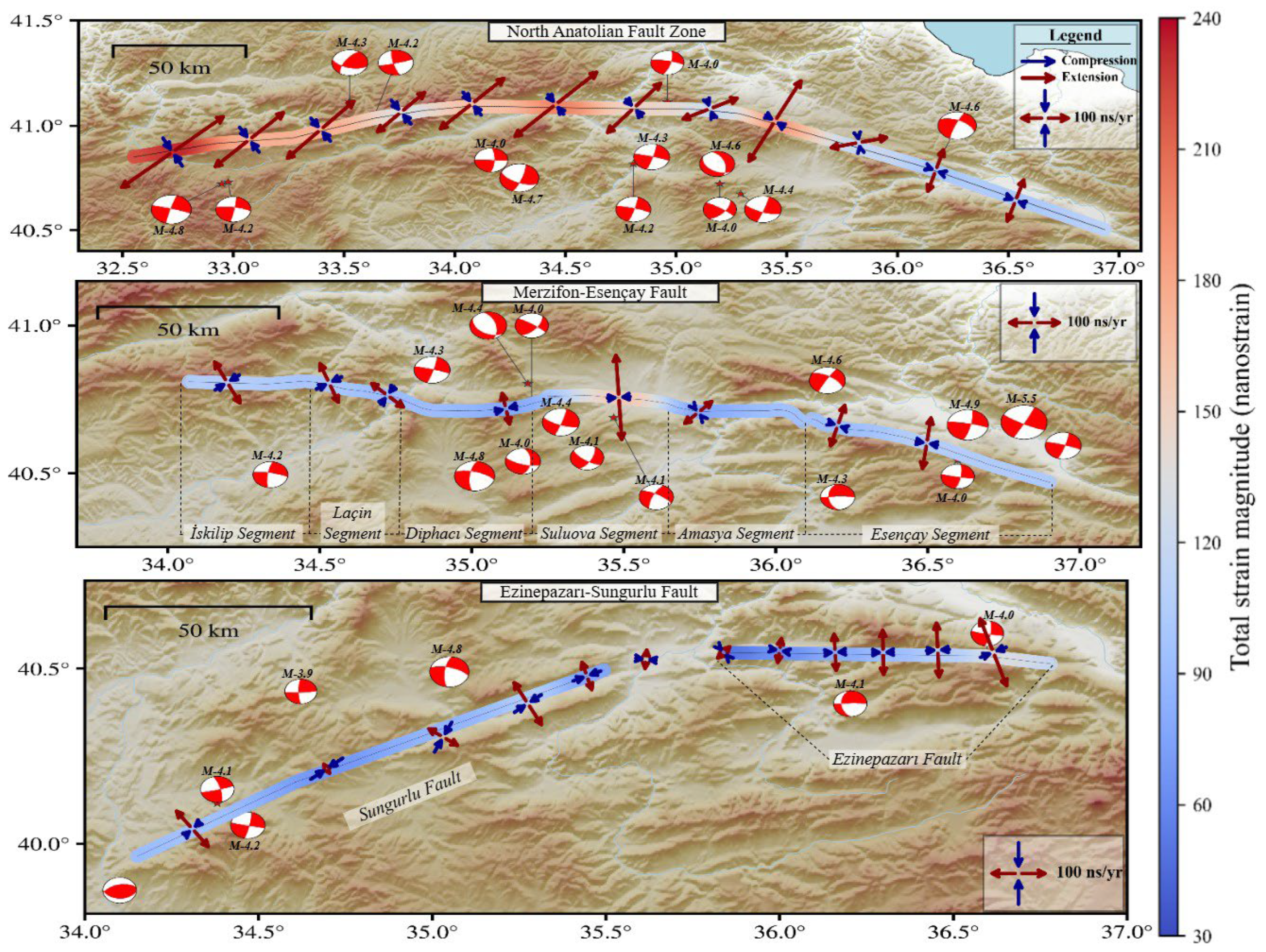
Beyond its regional-scale consistency with previous geodetic models, the high-resolution strain field presented in Figure 4 demonstrates that deformation within the central NAFZ is not confined to the main fault strand but is instead distributed across a complex multi-segmented fault system. This deformation pattern is compatible with the positive flower structure previously proposed for the region [30]. The derived strain field is characterized by dominant compressional strain components ranging from approximately −90 to −250 ns/yr, together with localized extensional zones reaching +90 to +160 ns/yr near segment boundaries. These spatial variations indicate that although strike-slip tectonics dominate the regional deformation regime, localized transtensional and transpressional domains develop in response to bends, segment transitions, and structural discontinuities within the fault geometry, consistent with the tectonic framework proposed by [12]. The derived strain orientations further show strong agreement with focal mechanism solutions reported by [76,77]. In contrast to the relatively high strain accumulation observed along the central and western sections of the fault system, the eastern parts exhibit noticeably lower strain rates. This reduction is particularly evident along the Destek segment, where previous studies suggested that approximately 30–40% of the deformation may be accommodated through aseismic creep [78]. The reduced strain accumulation observed in the present study is consistent with this interpretation and suggests that deformation along the central NAFZ is strongly controlled by segment-scale geometric and kinematic complexities. Also, the strain partitioning pattern obtained in this study is also broadly consistent with InSAR-based observations from the main strand of NAFZ. Ref. [79] reported that interseismic deformation is primarily concentrated along the main fault strand and exhibits significant along-strike variability in slip accumulation rates. Although the methodologies and geodetic observables differ, these observations support the heterogeneous deformation pattern and segment-scale strain variability identified in the present GNSS-derived strain field. Furthermore, previous studies conducted in different tectonic regions of Türkiye have demonstrated good agreement between InSAR-derived deformation fields and GNSS-based geodetic observations, indicating that the major deformation patterns resolved by these independent techniques are generally consistent [80,81].
A systematic decrease in strain rates is observed away from the main fault zone toward both the northern and southern edges of the study area (Figure 7). The observed spatial decay in strain further supports the interpretation that the NAFZ constitutes the principal carrier of active tectonic deformation within the region. The highest strain concentrations spatially coincide with the main fault strand and with the locations of major earthquakes that occurred along the central and eastern NAFZ during the instrumental period. In particular, the 1939 Erzincan, 1942 Niksar–Erbaa, 1943 Tosya–Ladik, and 1951 Kurşunlu earthquakes, which collectively define the well-known east-to-west migrating rupture sequence, all occurred along the main fault strand. These observations indicate that seismic energy release and elastic strain accumulation during the instrumental period were predominantly concentrated along the main fault system [12,20,24,82,83]. The observed strain distribution is also compatible with previously proposed slip partitioning models and positive flower structure geometries for the region [30,37].
One of the most structurally significant secondary splay systems within the central NAFZ is the MEF, where the derived strain rates reveal a balanced coexistence of extensional (+50 to +160 ns/yr) and compressional (−85 to −180 ns/yr) deformation components. This combined deformation pattern indicates that the fault system largely preserves its dominant strike-slip kinematic character and is generally consistent with the paleoseismological observations of [18], the kinematic interpretations of [39], and InSAR-based deformation analyses presented by [44]. Within the MEF, localized extensional strain components reaching +160 ns/yr are particularly prominent along the Esençay segment, indicating the development of a transtensional deformation regime. The dominance of extensional deformation relative to neighboring segments further suggests that secondary dip-slip components accompany the prevailing strike-slip motion in this section. This interpretation is compatible with block model–based geodetic solutions proposed by [37], which indicate a more complex kinematic regime along the Amasya, Suluova and Esençay segments. Focal mechanism solutions for earthquakes occurring along the MEF further support the strain-derived deformation pattern. In particular, the Mw ~4.0 earthquake along the Esençay section and Mw > 4 earthquakes recorded along the Laçin and Diphacı segments exhibit focal mechanisms compatible with the local strain regime inferred from the geodetic data. In addition, the Mw 4.4 earthquake that occurred along the Suluova segment in 2025 displays a reverse-faulting mechanism consistent with the dominant compressional strain components observed in this section. The pronounced compressional deformation identified along the Suluova segment is also compatible with the transpressional character of the restraining jog previously defined by [18]. Toward the western sections of the MEF, compressional strain components become increasingly dominant, particularly along the İskilip and Laçin segments, indicating a transition toward a more compressional deformation regime. Ref. [18] suggested that the İskilip segment forms the western termination of the MEF and structurally interacts with the Çankırı reverse fault system. Accordingly, this segment may represent a structural transition zone where strike-slip deformation is accompanied by significant compressional components. This interpretation is further supported by geodetic slip-rate models proposed by [37], which indicate dip-slip components of approximately 3–4 mm/yr along the western sections of the MEF.
Along the Sungurlu segment, located south of the main fault strand, strain rates systematically decrease from east to west, indicating progressively reduced deformation toward the western sections of the fault. Compressional strain components dominate along most parts of the segment, although localized strike-slip components are also observed, suggesting a kinematically heterogeneous deformation regime. This strain pattern is consistent with previous geodetic and morphotectonic studies indicating that slip rates along the Ezinepazarı–Sungurlu Fault decrease westward [12,36,84]. The weakening geomorphic expression and free-ending structural geometry observed toward the western termination of the Sungurlu segment [35] further support the interpretation that deformation along this structure is spatially limited and partitioned. The strain field derived along the EzF, which forms the western continuation of the Sungurlu segment, indicates that this structure actively accommodates part of the regional deformation. Compressional strain components ranging between approximately −50 and −100 ns/yr coexist with localized extensional values (+90 to +130 ns/yr) concentrated near segment boundaries, reflecting a structurally complex deformation regime. These observations are compatible with the kinematic model proposed by [84] and support the development of localized transtensional zones near segment transitions. Similarly, the compressional fault geometry and structural segmentation identified by [20] suggest that local transtensional deformation develops in response to complex stress interactions along the fault system. Overall, the geodetic strain field provides independent support for the previously proposed segmentation model of the Ezinepazarı–Sungurlu fault system.
Along the Ekinveren segment, which forms the northernmost structural component of the central NAFZ, the derived strain field exhibits lower amplitudes relative to the main fault strand. Although localized extensional components are present, deformation along the segment is predominantly characterized by compressional strain, suggesting a weak-to-moderate transpressional regime accompanying the dominant strike-slip tectonics of the NAFZ. This deformation pattern is compatible with the positive flower structure model commonly associated with right-lateral strike-slip fault systems, in which secondary fault branches accommodate localized compression, uplift, and reverse or oblique-slip deformation. Accordingly, the Ekinveren segment may represent a transpressional subsidiary structure within the broader deformation architecture of the central NAFZ.

4.2. Earthquake Recurrence Periods

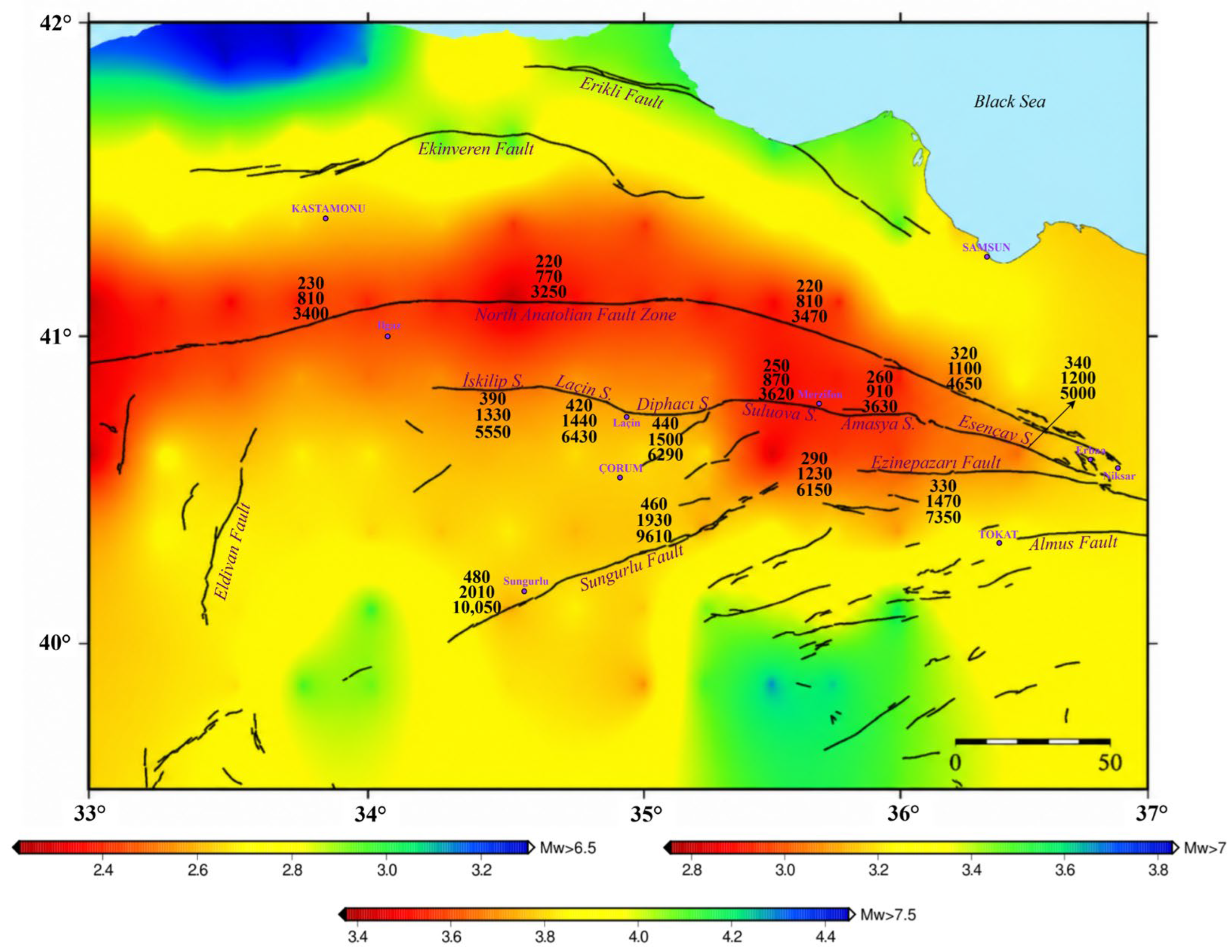
Given that strain accumulation controls the seismic cycle, the observed spatial distribution of strain provides a fundamental framework for interpreting earthquake recurrence periods across different fault segments. Similar to the derived strain distribution, the geodetic earthquake recurrence periods indicate that seismic potential within the central segment of the NAFZ is not concentrated solely along the main fault strand but is also significantly partitioned among major splay fault systems such as the MEF, Ezinepazarı, Sungurlu, Eldivan, and Ekinveren faults. The spatial distribution of the recurrence periods presented in Figure 5 demonstrates that the shortest geodetic earthquake recurrence periods spatially comply with regions characterized by the highest strain rates. Along the main strand of the NAFZ, particularly across the principal segments ruptured during the 1942 and 1943 earthquakes (Mw 7.1–7.4), the estimated geodetic recurrence periods for Mw > 7 earthquake scenarios range approximately between 770 and 1200 years. These values represent the shortest recurrence periods within the study area and prove that the main fault strand plays a dominant role in the release of accumulated seismic energy.
The combined evaluation of paleoseismological evidence and geodetically derived earthquake recurrence periods suggests a scale-dependent seismic behavior along the central NAFZ. While paleoseismological records indicate relatively frequent earthquake occurrence with recurrence periods on the order of ~400 ± 150 years, the comparatively longer but internally consistent geodetic recurrence intervals estimated for Mw > 7 earthquake scenarios indicate that large-scale ruptures require substantially longer periods of strain accumulation. When compared with paleoseismological constraints, this discrepancy primarily reflects differences in rupture scale. Paleoseismological observations generally record segment-scale surface-rupturing earthquakes, whereas geodetic estimates represent the strain accumulation necessary for larger multi-segment or system-wide rupture scenarios [85]. In addition to rupture-scale dependence, this behavior is also strongly influenced by deformation partitioning within the fault system. Geodetic observations indicate that although the main fault strand accommodates the majority of regional plate motion (~19 mm/yr), approximately 10–15% of the total deformation budget is distributed across splay faults and subsidiary structures. This distributed deformation lowers the effective strain accumulation rate on individual structures, particularly along secondary faults, and therefore contributes to the longer and spatially variable recurrence intervals observed outside the principal fault zone. Furthermore, the ~1100-year recurrence interval estimated for Mw > 7 earthquake scenarios along the Destek segment, located in the eastern part of the main fault strand, provides additional insight into this behavior. When considered together with the aseismic creep behavior previously identified in this segment [78], these results suggest that although part of the deformation is continuously released through creep-related processes, a substantial portion of the total slip deficit continues to accumulate. Accordingly, the segment may continue to accumulate part of its slip deficit and therefore remains a potentially significant component of the regional seismic hazard framework.
A noticeable increase in earthquake recurrences is observed from the main fault strand toward the surrounding splay fault systems. Along the MEF, estimated recurrence intervals for Mw > 7 earthquakes range between approximately 870 and 1500 years, indicating relatively slower strain accumulation compared to the main NAFZ strand. The Esençay segment is particularly notable, with geodetically derived recurrence periods of ~1200 years that are broadly consistent with paleoseismological constraints indicating recurrence periods of 1320–2200 years and no major surface-rupturing event during the last ~3700 years [18]. Together with the pronounced extensional strain components observed in the strain rates, these findings suggest that the segment accumulates deformation under a transtensional regime characterized by long-term strain storage and delayed seismic release. However, these observations should be interpreted as evidence of long-term strain accumulation rather than a direct indication of an imminent future rupture. Other segments within the MEF system exhibit distinct recurrence behaviors depending on their local kinematic characteristics. The comparatively shorter recurrence intervals estimated for the Amasya and Suluova segments (~900 years for Mw > 7 scenarios) imply more efficient strain accumulation, whereas the substantially longer intervals obtained for the İskilip, Laçin, and Diphacı segments (~1500 years) indicate slower deformation rates. The dominant compressional strain components observed along these latter segments further suggest that their prolonged recurrence behavior is associated with restraining geometries and localized transpressional deformation.
The Ezinepazarı Fault, an active splay segment that produced surface rupture during the 1939 Erzincan earthquake, exhibits geodetic recurrence periods of ~1500 years for Mw > 7 earthquake scenarios. These values indicate a comparatively longer seismic cycle relative to the main NAFZ strand and suggest that strain accumulation has progressively resumed following the 1939 rupture. Paleoseismological investigations by [18] proposed recurrence intervals ranging between 899 and 1159 years for the period between the 1939 event and the preceding major earthquake, yielding values broadly consistent with the geodetic estimates obtained in this study. In contrast, ref. [20] reported substantially more variable inter-event durations ranging from 288 to 4220 years, indicating that earthquake recurrence behavior along the Ezinepazarı segment may be considerably more complex and temporally heterogeneous.
The Sungurlu and Eldivan faults are characterized by comparatively longer earthquake recurrences, suggesting a relatively low short-term probability of generating Mw > 7 earthquakes. The longer recurrence intervals estimated for the Sungurlu Fault relative to the Ezinepazarı segment are consistent with the limited evidence for Holocene surface ruptures reported in previous studies [35]. However, both geodetically derived slip rates [37] and regional kinematic interpretations indicate that the fault is not tectonically inactive, but rather represents an active structure characterized by longer seismic cycles and localized compressional components.

4.3. Contemporary Seismic Potential of the Central NAFZ

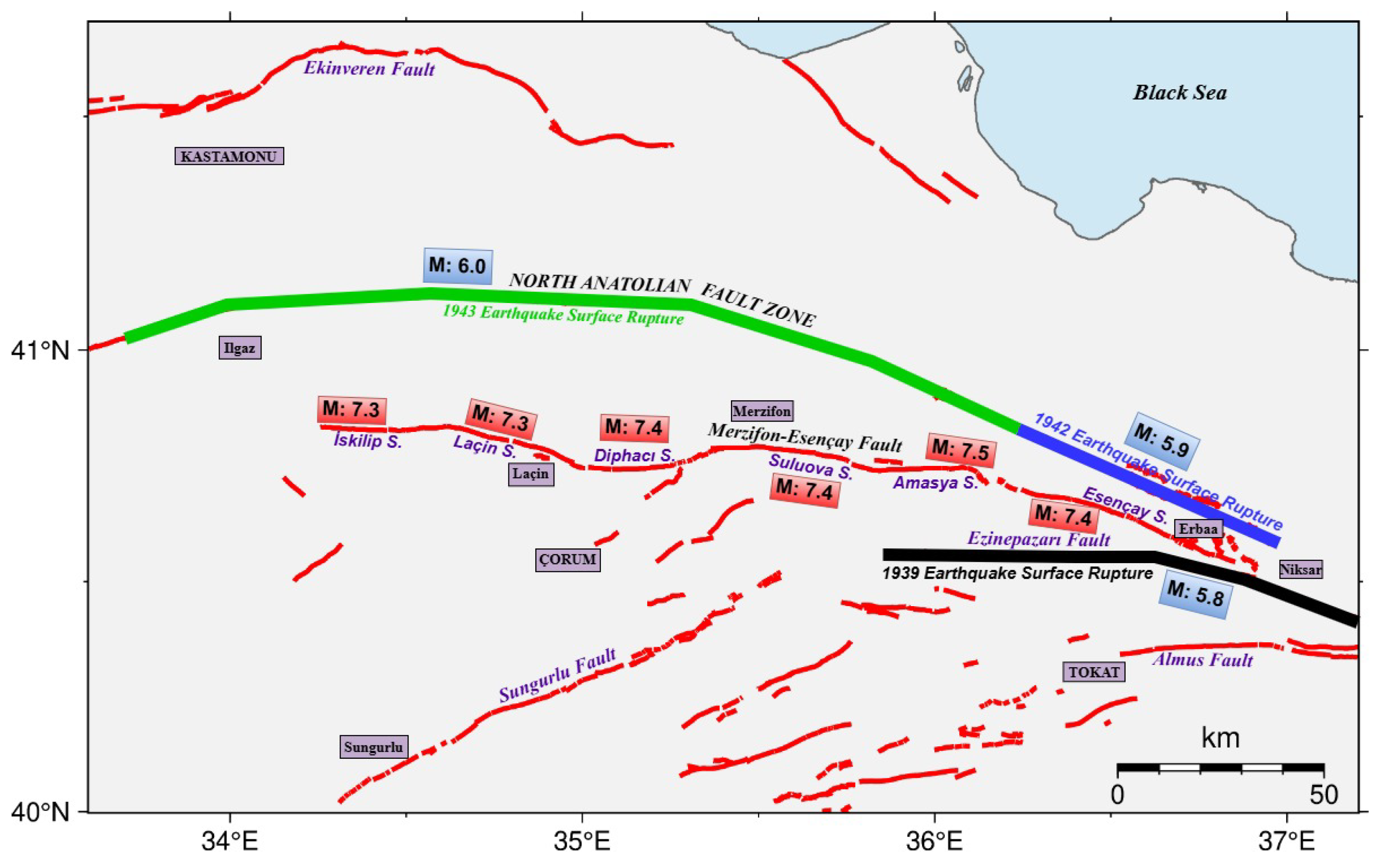
The quantitative results derived from the strain analysis and geodetic earthquake recurrence modeling presented above indicate that individual segments along the central NAFZ exhibit distinct seismic potentials. Considering the strain accumulated along the main fault strand since the 1942–1943 earthquake sequence, together with the segment lengths reported by [25] and the slip-rate estimates proposed by [37] the current deformation state corresponds to a potential earthquake magnitude of approximately Mw 6.0 ± 0.2 (Figure 6). The potential earthquake magnitudes estimated for the main strand of the NAFZ using the 1942 and 1943 earthquakes as temporal reference events are consistent with the multi-segment surface ruptures and large displacements documented along this section during the twentieth century [12,16,24]. Also, previous studies have further emphasized that the 1942 and 1943 earthquakes, which formed part of the westward migrating rupture sequence initiated by the 1939 Erzincan earthquake, produced substantial strain release at the segment scale. Nevertheless, the elapsed interseismic period since these events has allowed significant strain to accumulate once again along the fault system [16,25].
The potential earthquake magnitudes estimated for the EzF are approximately Mw 5.8 ± 0.2, lower than several maximum magnitude estimates previously proposed for this fault in the literature. Nevertheless, studies based on the empirical relationships of [86] suggest that the fault may be capable of generating larger earthquakes once sufficient long-term strain accumulation is achieved along the fault system [16,20]. A particularly significant result was obtained for the MEFZ, where comparatively high strain values correspond to an estimated earthquake potential of approximately Mw 7.3–7.5 ± 0.2 (Figure 6). This estimate is consistent with both paleoseismological evidence and empirical magnitude–rupture length relationships previously proposed for the segments [16,18]. The fact that the most recent major earthquake occurred approximately 3700 years ago further indicates prolonged strain accumulation along the segment. When considered together with the derived strain field and recurrence behavior, the Esençay segment emerges as one of the sections exhibiting the highest levels of accumulated strain and geodetically inferred seismic potential within the central NAFZ. Collectively, these findings demonstrate that the MEFZ is capable of accumulating substantial seismic energy at the segment scale and that the derived geodetic estimates indicate elevated seismic potential associated with long-term strain accumulation within the fault zone. The independently derived single-segment magnitude estimates locally reach Mw > 7.2, emphasizing the significant seismic potential of the MEFZ.

5. Conclusions

This study presents a comprehensive geodetic assessment of strain partitioning, earthquake recurrence behavior, and seismic potential along the central part of the NAFZ and its associated splay fault systems. Using a high-resolution GNSS-derived velocity field integrated with strain-rate analysis and geodetic earthquake recurrence modeling, the spatial distribution of present-day deformation was resolved at the segment scale across both the main fault strand and secondary tectonic structures. Considering that the NAFZ represents one of the most tectonically active and seismically destructive intracontinental strike-slip fault systems accommodating the westward escape of the Anatolian Plate, resolving the spatial variability of strain accumulation along its central segments is of critical importance for understanding regional seismic hazard. The derived geodetic results provide new constraints on deformation partitioning within the central NAFZ and reveal that strain accumulation is distributed across a structurally complex and kinematically heterogeneous fault network rather than being confined solely to the main fault strand.
The obtained strain field demonstrates that although the main strand of the NAFZ accommodates the majority of regional deformation, significant portions of strain are also transferred to surrounding splay fault systems, where localized transtensional and transpressional regimes develop depending on segment geometry and structural interactions. The spatial variability observed in the strain field is further reflected in the estimated earthquake recurrence periods and seismic potential. Segments characterized by relatively high strain rates generally exhibit shorter recurrence periods, whereas structurally complex splay faults display longer earthquake cycles associated with slower but persistent strain accumulation. In this context, one of the most significant findings of this study is the elevated seismic potential identified along the MEF. The coexistence of elevated strain accumulation and geodetically derived recurrence characteristics suggests elevated seismic potential along several segments of the MEF. In particular, the Esençay segment, where paleoseismological evidence indicates the absence of a major surface-rupturing earthquake for approximately 3700 years, may represent a candidate seismic gap within the central NAFZ system. In addition, the estimated seismic potential reaching approximately Mw 7.3–7.5 for the MEF indicates that individual segments of the fault system may accumulate sufficient strain to generate large-magnitude earthquakes under single-segment rupture conditions. Nevertheless, elevated strain accumulation and prolonged elapsed time since the last major rupture should not be interpreted as indicators of imminent earthquake occurrence, as earthquake generation is additionally controlled by fault frictional properties, stress interactions, rupture dynamics, and aseismic deformation processes.
Overall, the findings presented in this study emphasize the importance of incorporating segment-scale deformation processes into regional seismic hazard assessments within the central NAFZ. The integration of multiple datasets and seismological observations provides a physically consistent framework for evaluating fault interaction and seismic potential in complex multi-segmented strike-slip systems. These results may contribute to future seismic hazard evaluations and regional risk mitigation strategies for densely populated regions located along the central NAFZ. Although the GNSS network employed in this study represents the densest geodetic dataset currently available for the central NAFZ, the spatial resolution of the derived strain field remains dependent on station distribution and network geometry, and therefore may vary locally across individual fault segments. Accordingly, the present results remain open to further refinement through future network densification. Nevertheless, further integration of high-resolution geodetic observations with geological, paleoseismological, and seismological datasets will be necessary to better constrain the temporal evolution of deformation processes and the rupture behavior of individual fault segments. Such multidisciplinary approaches will provide more robust insight into the spatial and temporal variability of strain accumulation and earthquake generation along the NAFZ system.

Author Contributions

Conceptualization, İ.T., H.H.Y. and V.E.G.; methodology, K.A., İ.T., C.G. and H.İ.S.; software, İ.T., K.A. and H.İ.S.; validation, H.H.Y. and İ.T.; formal analysis, K.A., İ.T. and C.G.; investigation, İ.T., K.A., H.H.Y. and C.G.; resources, K.A. and V.E.G.; data curation, K.A. and H.İ.S.; writing—original draft preparation, K.A., İ.T. and C.G.; writing—review and editing, C.G. and H.İ.S.; visualization, K.A. and H.İ.S.; supervision, V.E.G. and İ.T.; project administration, K.A.; funding acquisition, K.A. All authors have read and agreed to the published version of the manuscript.

Funding

This research was funded by the Scientific and Technological Research Council of Turkey (TÜBİTAK) under the project no: 123Y293.

Data Availability Statement

The data presented in this study are available on reasonable request from the first author. The data are not publicly available due to privacy and ethical restrictions.

Acknowledgments

During the preparation of this manuscript, the author used ChatGPT-5.3 (OpenAI, San Francisco, CA, USA) for the purpose of language editing and improving clarity. After using this tool, the author reviewed and edited the content thoroughly and takes full responsibility for the content of the published article.

Conflicts of Interest

The authors declare no conflicts of interest.

References

  1. Reid, H.F. The Mechanism of the Earthquake. The California Earthquake of April 18, 1906. Rep. State Earthq. Investig. Comm. 1910, 2, 16–18. [Google Scholar]
  2. Tiryakioǧlu, I.; Floyd, M.; Erdoǧan, S.; Gülal, E.; Ergintav, S.; McClusky, S.; Reilinger, R. GPS Constraints on Active Deformation in the Isparta Angle Region of SW Turkey. Geophys. J. Int. 2013, 195, 1455–1463. [Google Scholar] [CrossRef]
  3. Solak, H.İ. Prediction of GNSS Velocity Accuracies Using Machine Learning Algorithms for Active Fault Slip Rate Determination and Earthquake Hazard Assessment. Appl. Sci. 2024, 15, 113. [Google Scholar] [CrossRef]
  4. Liu, J.; Huang, C.; Zhang, G.; Shan, X.; Korzhenkov, A.; Taymaz, T. Immature Characteristics of the East Anatolian Fault Zone from SAR, GNSS and Strong Motion Data of the 2023 Türkiye–Syria Earthquake Doublet. Sci. Rep. 2024, 14, 10625. [Google Scholar] [CrossRef] [PubMed]
  5. Kazimov, I.; Yetirmishli, G.; Aktŭ, G.B.; Tiryakiŏ Glu, I.; Gezgin, C.; Solak, I.; Doruk¸sentürk, M.; Doruk¸sentürk, D.; Kazimova, S.; Kazimova, A. Active Tectonics, Crustal Strain Fields and Block Behavior around the Caucasus Transition Zone: Constraints from Combined GNSS Velocities. Eur. Phys. J. Plus 2026, 141, 537. [Google Scholar] [CrossRef]
  6. Yaşar, S.; Solak, I.; Tiryakioğlu, I.; Aktuğ, B.; Şentürk, D.M.; Engin Gülal, V. Magnitude Estimation of the 2025 Sındırgı Earthquakes Using High-Rate GNSS-Derived Peak Ground Displacement (PGD): Insights from Low-Cost and Geodetic Receivers. Appl. Sci. 2026, 16, 5535. [Google Scholar] [CrossRef]
  7. Arnoso, J.; Riccardi, U.; Benavent, M.; Tammaro, U.; Montesinos, F.G.; Blanco-Montenegro, I.; Vélez, E. Strain Pattern and Kinematics of the Canary Islands from GNSS Time Series Analysis. Remote Sens. 2020, 12, 3297. [Google Scholar] [CrossRef]
  8. Kreemer, C.; Young, Z.M. Crustal Strain Rates in the Western United States and Their Relationship with Earthquake Rates. Seismol. Res. Lett. 2022, 93, 2990–3008. [Google Scholar] [CrossRef]
  9. Rashwan, M.; Sawires, R.; Radwan, A.M.; Sparacino, F.; Peláez, J.A.; Palano, M. Crustal Strain and Stress Fields in Egypt from Geodetic and Seismological Data. Remote Sens. 2021, 13, 1398. [Google Scholar] [CrossRef]
  10. Feng, L.; Hill, E.M.; Banerjee, P.; Hermawan, I.; Tsang, L.L.H.; Natawidjaja, D.H.; Suwargadi, B.W.; Sieh, K. A Unified GPS-Based Earthquake Catalog for the Sumatran Plate Boundary between 2002 and 2013. J. Geophys. Res. Solid Earth 2015, 120, 3566–3598. [Google Scholar] [CrossRef]
  11. Tin, T.Z.H.; Nishimura, T.; Hashimoto, M.; Lindsey, E.O.; Aung, L.T.; Min, S.M.; Thant, M. Present-Day Crustal Deformation and Slip Rate along the Southern Sagaing Fault in Myanmar by GNSS Observation. J. Asian Earth Sci. 2022, 228, 105125. [Google Scholar] [CrossRef]
  12. Şengör, A.M.C.; Tüysüz, O.; Imren, C.; Sakinç, M.; Eyidoǧan, H.; Görür, N.; Le Pichon, X.; Rangin, C. The North Anatolian Fault: A New Look. Annu. Rev. Earth Planet. Sci. 2005, 33, 37–112. [Google Scholar] [CrossRef]
  13. Stein, R.S.; Barka, A.A.; Dieterich, J.H. Progressive Failure on the North Anatolian Fault since 1939 by Earthquake Stress Triggering. Geophys. J. Int. 1997, 128, 594–604. [Google Scholar] [CrossRef]
  14. Flerit, F.; Armijo, R.; King, G.; Meyer, B. The Mechanical Interaction between the Propagating North Anatolian Fault and the Back-Arc Extension in the Aegean. Earth Planet. Sci. Lett. 2004, 224, 347–362. [Google Scholar] [CrossRef]
  15. Ergintav, S.; Reilinger, R.E.; Çakmak, R.; Floyd, M.; Cakir, Z.; Doğan, U.; King, R.W.; McClusky, S.; Özener, H. Istanbul’s Earthquake Hot Spots: Geodetic Constraints on Strain Accumulation along Faults in the Marmara Seismic Gap. Geophys. Res. Lett. 2014, 41, 5783–5788. [Google Scholar] [CrossRef]
  16. Emre, Ö.; Duman, T.Y.; Özalp, S.; Şaroğlu, F.; Olgun, Ş.; Elmacı, H.; Çan, T. Active Fault Database of Turkey. Bull. Earthq. Eng. 2018, 16, 3229–3275. [Google Scholar] [CrossRef]
  17. Reilinger, R.; McClusky, S.; Vernant, P.; Lawrence, S.; Ergintav, S.; Cakmak, R.; Ozener, H.; Kadirov, F.; Guliev, I.; Stepanyan, R.; et al. GPS Constraints on Continental Deformation in the Africa-Arabia-Eurasia Continental Collision Zone and Implications for the Dynamics of Plate Interactions. J. Geophys. Res. Solid Earth 2006, 111, 5411. [Google Scholar] [CrossRef]
  18. Emre, Ö.; Elmacı, H.; Özalp, S.; Kırman, E. Merzifon–Esençay Splay Fault within the North Anatolian Fault System: Segmentation and Timing of the Last Two Surface Faulting Events on Esençay Segment. Mediterr. Geosci. Rev. 2020, 2, 359–382. [Google Scholar] [CrossRef]
  19. Fraser, J.G.; Hubert-Ferrari, A.; Verbeeck, K.; Garcia-Moreno, D.; Avsar, U.; Maricq, N.; Coudijzer, A.; Vlamynck, N.; Vanneste, K. A 3000-Year Record of Surface-Rupturing Earthquakes at Günalan: Variable Fault-Rupture Lengths along the 1939 Erzincan Earthquake-Rupture Segment of the North Anatolian Fault, Turkey. Ann. Geophys. 2012, 55, 895–927. [Google Scholar] [CrossRef]
  20. Koçbulut, F. Evidence for Surface Rupture of the 1939 Erzincan Earthquake Based on Field Data and Paleoseismology on the Ezinepazarı Fault (North Anatolian Fault Zone, Central Anatolia). Turk. J. Earth Sci. 2023, 32, 96–112. [Google Scholar] [CrossRef]
  21. Yavasoglu, H. Análisis de La Velocidad de Deformación En El Segmento Çankırı-Bingöl de La Falla de Anatolia Del Norte, Turquía. Earth Sci. Res. J. 2015, 19, 121–127. [Google Scholar] [CrossRef]
  22. Dogru, A.; Gorgun, E.; Aktug, B.; Ozener, H. Seismic Hazard Assessment of the Central North Anatolian Fault (Turkey) from GPS-Derived Strain Rates and b-Values. Geomat. Nat. Hazards Risk 2018, 9, 356–367. [Google Scholar] [CrossRef]
  23. Ketin, I. Über Die Tektonisch-Mechanischen Folgerungen Aus Den Großen Anatolischen Erdbeben Des Letzten Dezenniums. Geol. Rundsch. 1948, 36, 77–83. [Google Scholar] [CrossRef]
  24. Barka, A. Slip Distribution along the North Anatolian Fault Associated with the Large Earthquakes of the Period 1939 to 1967. Bull. Seismol. Soc. Am. 1996, 86, 1238–1254. [Google Scholar] [CrossRef]
  25. Emre, Ö.; Kondo, H.; Özalp, S.; Elmacı, H. Fault Geometry, Segmentation and Slip Distribution Associated with the 1939 Erzincan Earthquake Rupture along the North Anatolian Fault, Turkey. Geol. Soc. Spec. Publ. 2021, 501, 23–70. [Google Scholar] [CrossRef]
  26. Aladoğan, K.; Alkan, M.N.; Tiryakioğlu, İ.; Yavaşoğlu, H.H.; Solak, H.İ.; Gezgin, C.; Özkan, A.; Eyübagil, E.E.; Şahiner, F.; Çakanşimşek, E.B.; et al. Preliminary Results on Deformations of the Central North Anatolian Fault Zone. Hittite J. Sci. Eng. 2024, 11, 115–122. [Google Scholar] [CrossRef]
  27. KOERI Kandilli Observatory and Earthquake Research Institute—Istanbul. Bogazici University Kandilli Observatory and Earthquake Research Institute, Turkey [Data Set]; KOERI Kandilli Observatory and Earthquake Research Institute: Istanbul, Turkey.
  28. Ellero, A.; Ottria, G.; Marroni, M.; Pandolfi, L.; Göncüoğlu, M.C. Analysis of the North Anatolian Shear Zone in Central Pontides (Northern Turkey): Insight for Geometries and Kinematics of Deformation Structures in a Transpressional Zone. J. Struct. Geol. 2015, 72, 124–141. [Google Scholar] [CrossRef]
  29. Taymaz, T.; Wright, T.J.; Yolsal, S.; Tan, O.; Fielding, E.; Seyitoǧlu, G. Source Characteristics of the 6 June 2000 Orta–Çankırı (Central Turkey) Earthquake: A Synthesis of Seismological, Geological and Geodetic (InSAR) Observations, and Internal Deformation of the Anatolian Plate. Geol. Soc. Spec. Publ. 2007, 291, 259–290. [Google Scholar] [CrossRef]
  30. Yildirim, C.; Schildgen, T.F.; Echtler, H.; Melnick, D.; Strecker, M.R. Late Neogene and Active Orogenic Uplift in the Central Pontides Associated with the North Anatolian Fault: Implications for the Northern Margin of the Central Anatolian Plateau, Turkey. Tectonics 2011, 30, TC5005. [Google Scholar] [CrossRef]
  31. Aladoğan, K. Kuzey Anadolu Fay Zonu (KAFZ) Orta Segmentinin Blok Hareketlerinin GNSS Ile Belirlenmesi. Ph.D. Thesis, Afyon Kocatepe Üniversitesi, Afyon, Turkey, 2025. [Google Scholar]
  32. Ballato, P.; Parra, M.; Schildgen, T.F.; Dunkl, I.; Yıldırım, C.; Özsayın, E.; Sobel, E.R.; Echtler, H.; Strecker, M.R. Multiple Exhumation Phases in the Central Pontides (N Turkey): New Temporal Constraints on Major Geodynamic Changes Associated with the Closure of the Neo-Tethys Ocean. Tectonics 2018, 37, 1831–1857. [Google Scholar] [CrossRef]
  33. Ocakoğlu, N.; İşcan, Y.; Kılıç, F.; Özel, O. Morphologic and Seismic Evidence of Rapid Submergence Offshore Cide-Sinop in the Southern Black Sea Shelf. Geomorphology 2018, 311, 76–89. [Google Scholar] [CrossRef]
  34. Işseven, T.; Tüysüz, O. Palaeomagnetically Defined Rotations of Fault-Bounded Continental Blocks in the North Anatolian Shear Zone, North Central Anatolia. J. Asian Earth Sci. 2006, 28, 469–479. [Google Scholar] [CrossRef]
  35. Koçbulut, F.; Kavak, K.Ş.; Tatar, O. Analysis of Ezinepazarı–Sungurlu Fault Zone (Turkey) Using Landsat TM Data and Its Kinematic Implications. Arab. J. Geosci. 2015, 8, 6425–6439. [Google Scholar] [CrossRef]
  36. Yavaşoĝlu, H.; Tari, E.; Tüysüz, O.; Çakir, Z.; Ergintav, S. Determining and Modeling Tectonic Movements along the Central Part of the North Anatolian Fault (Turkey) Using Geodetic Measurements. J. Geodyn. 2011, 51, 339–343. [Google Scholar] [CrossRef]
  37. Aladogan, K.; Tiryakioglu, I.; Solak, H.I.; Yavaşoğlu, H.H.; Gezgin, C.; Sözbilir, H.; Alkan, M.N.; Özkan, A.; Çakanşimşek, E.B. Slip Rate Partitioning among Fault Segments in the Central Part of North Anatolian Fault Zone. J. Mt. Sci. 2026, 23, 2369–2387. [Google Scholar] [CrossRef]
  38. Erturaç, M.K.; Erdal, O.; Sunal, G.; Tüysüz, O.; Şen, Ş. Quaternary Evolution of the Suluova Basin: Implications on Tectonics and Palaeonvironments of the Central North Anatolian Shear Zone1. Can. J. Earth Sci. 2019, 56, 1239–1261. [Google Scholar] [CrossRef]
  39. Rojay, F.B.; Koçyiğit, A. An Active Composite Pull-Apart Basin Within the Central Part of the North Anatolian Fault System: The Merzifon-Suluova Basin, Turkey. Turk. J. Earth Sci. 2012, 21, 473–496. [Google Scholar] [CrossRef]
  40. Erturaç, M.; Tüysüz, O. Amasya ve Çevresinin Neojen Stratigrafisi ve Ne-Otektonik Evrimi: Kuzey Anadolu Fay Sistemi’nin Orta Kesimi. 62; Türkiye Jeoloji Kurultayı: Ankara, Turkey, 2009. [Google Scholar]
  41. Bozkurt, E.; Kocyiğit, A. Almus Fault Zone: Its Age, Total off Set and Relation to the North Anatolian Fault Zone. Turk. J. Earth Sci. 1995, 4, 93–104. [Google Scholar]
  42. Bozkurt, E. Neotectonics of Turkey–a Synthesis. Geodin. Acta 2001, 14, 3–30. [Google Scholar] [CrossRef]
  43. Bayrak, Y.; Çınar, H.; Bayrak, E. The North Anatolian Fault Zone: An Evaluation of Earthquake Hazard Parameters. In New Frontiers in Tectonic Research: At The Midst of Plate Convergence; Schattner, U., Ed.; Intech Open Access Publisher: Rijeka, Croatia, 2011; Volume 10, pp. 269–288. [Google Scholar]
  44. Peyret, M.; Masson, F.; Yavasoglu, H.; Ergintav, S.; Reilinger, R. Present-Day Strain Distribution across a Segment of the Central Bend of the North Anatolian Fault Zone from a Persistent-Scatterers InSAR Analysis of the ERS and Envisat Archives. Geophys. J. Int. 2013, 192, 929–945. [Google Scholar] [CrossRef]
  45. Svarc, J.L.; Savage, J.C.; Prescott, W.H.; Ramelli, A.R. Strain Accumulation and Rotation in Western Nevada, 1993–2000. J. Geophys. Res. Solid Earth 2002, 107, ETG 2-1. [Google Scholar] [CrossRef]
  46. Beavan, J.; Haines, J. Contemporary Horizontal Velocity and Strain Rate Fields of the Pacific-Australian Plate Boundary Zone through New Zealand. J. Geophys. Res. Solid Earth 2001, 106, 741–770. [Google Scholar] [CrossRef]
  47. Tiryakioğlu, I.; Tiryakioğlu, I.; Özkaymak, Ç.; Baybura, T.; Sözbilir, H.; Uysal, M. Comparison of Palaeostress Analysis, Geodetic Strain Rates and Seismic Data in the the Western Part of the Sultandağı Fault in Turkey. Ann. Geophys. 2018, 61, GD335. [Google Scholar] [CrossRef]
  48. Cambiotti, G.; Palano, M.; Orecchio, B.; Marotta, A.M.; Barzaghi, R.; Neri, G.; Sabadini, R. New Insights into Long-Term Aseismic Deformation and Regional Strain Rates from GNSS Data Inversion: The Case of the Pollino and Castrovillari Faults. Remote Sens. 2020, 12, 2921. [Google Scholar] [CrossRef]
  49. Bilgilioğlu, S.S.; Gezgin, C.; Solak, H.İ.; Tiryakioğlu, İ. A Novel Approach for Earthquake Spatial Probability Modeling by Integration of Geodetic Strain into Explainable Artificial Intelligence (XAI). Stoch. Environ. Res. Risk Assess. 2026, 40, 18. [Google Scholar] [CrossRef]
  50. Solak, H.İ.; Tiryakioğlu, İ.; Özkaymak, Ç.; Gezgin, C.; Özyildirim, Ö.; Çakanşimşek, E.B.; Aladoğan, K. Geodetic Analysis of Seismic Behavior in the Afyon-Akşehir Graben, Western Anatolia. J. Afr. Earth Sci. 2026, 237, 106066. [Google Scholar] [CrossRef]
  51. Shen, Z.K.; Jackson, D.D.; Ge, B.X. Crustal Deformation across and beyond the Los Angeles Basin from Geodetic Measurements. J. Geophys. Res. Solid Earth 1996, 101, 27957–27980. [Google Scholar] [CrossRef]
  52. Aktug, B.; Nocquet, J.M.; Cingöz, A.; Parsons, B.; Erkan, Y.; England, P.; Lenk, O.; Gürdal, M.A.; Kilicoglu, A.; Akdeniz, H.; et al. Deformation of Western Turkey from a Combination of Permanent and Campaign GPS Data: Limits to Block-like Behavior. J. Geophys. Res. Solid Earth 2009, 114, B10404. [Google Scholar] [CrossRef]
  53. Yavasoglu, H.H.; Tiryakioglu, I.; Karabulut, M.F.; Eyubagil, E.E.; Ozkan, A.; Masson, F.; Klein, E.; Gulal, V.E.; Alkan, R.M.; Alkan, M.N.; et al. New Geodetic Constraints to Reveal Seismic Potential of Central Marmara Region, Turkey. Bull. Geophys. Oceanogr. 2021, 62, 513–526. [Google Scholar] [CrossRef]
  54. Gezgin, C.; Ekercin, S.; Tiryakioğlu, I.; Aktuğ, B.; Erdoğan, H.; Gürbüz, E.; Orhan, O.; Bilgilioğlu, S.S.; Torun, A.T.; Gündüz, H.İ.; et al. Determination of Recent Tectonic Deformations along the Tuz Gölü Fault Zone in CentralAnatolia (Turkey) with GNSS Observations. Turk. J. Earth Sci. 2022, 31, 20–33. [Google Scholar] [CrossRef]
  55. Özkan, A.; Solak, H.İ.; Tiryakioğlu, İ.; Şentürk, M.D.; Aktuğ, B.; Gezgin, C.; Poyraz, F.; Duman, H.; Masson, F.; Uslular, G.; et al. Characterization of the Co-Seismic Pattern and Slip Distribution of the February 06, 2023, Kahramanmaraş (Turkey) Earthquakes (Mw 7.7 and Mw 7.6) with a Dense GNSS Network. Tectonophysics 2023, 866, 230041. [Google Scholar] [CrossRef]
  56. GeodSuit GeodSuit Deformation Module User Manual, Cookbook. 2017. Available online: https://www.mdsoft.com.tr/Pages/Product_Geodsuit (accessed on 16 March 2026).
  57. D’Agostino, N. Complete Seismic Release of Tectonic Strain and Earthquake Recurrence in the Apennines (Italy). Geophys. Res. Lett. 2014, 41, 1155–1162. [Google Scholar] [CrossRef]
  58. Solak, H.İ.; Gezgin, C. Seismic Hazard Evaluation and Strain Dynamics in the Simav Fault Zone: A Comprehensive Analysis of Earthquake Recurrence and Energy Release Patterns. Appl. Sci. 2025, 15, 3039. [Google Scholar] [CrossRef]
  59. Tiryakioğlu, İ.; Gezgin, C.; Aktuğ, B.; Solak, H.İ.; Özkaymak, Ç.; Şafak Yaşar, Ş.; Şahiner, F.; Yıldırım, M.C.; Aladoğan, K.; Ünlükaya, E.B.Ç.; et al. Revealing the Source Mechanism of the August 10, 2025 Sındırgı Earthquake (Mw 6.3) with Geological and Geodetic Evidence. Adv. Space Res. 2026, 78, 580–598. [Google Scholar] [CrossRef]
  60. Wang, T.; Griffin, J.D.; Brenna, M.; Fletcher, D.; Zeng, J.; Stirling, M.; Dillingham, P.W.; Kang, J. Earthquake Forecasting from Paleoseismic Records. Nat. Commun. 2024, 15, 1944. [Google Scholar] [CrossRef] [PubMed]
  61. Gutenberg, B.; Richter, C.F. Frequency of Earthquakes in California. Bull. Seismol. Soc. Am. 1944, 34, 185–188. [Google Scholar] [CrossRef]
  62. Olsson, R. An Estimation of the Maximum B-Value in the Gutenberg-Richter Relation. J. Geodyn. 1999, 27, 547–552. [Google Scholar] [CrossRef]
  63. Mogi, K. Earthquakes and Fractures. Tectonophysics 1967, 5, 35–55. [Google Scholar] [CrossRef]
  64. Hanks, T.C.; Kanamori, H. A Moment Magnitude Scale. J. Geophys. Res. Solid Earth 1979, 84, 2348–2350. [Google Scholar] [CrossRef]
  65. Ward, S.N. On the Consistency of Earthquake Moment Release and Space Geodetic Strain Rates: Europe. Geophys. J. Int. 1998, 135, 1011–1018. [Google Scholar] [CrossRef]
  66. Aktug, B.; Sentürk, M.D.; Ozsaraç, V.; Kiliç, N. Jeodezik Deprem Tehlike Haritası. In Proceedings of the TMMOB Harita Ve Kadastro Mühendisleri Odası Türkiye Harita Bilimsel Ve Teknik Kurultayı, Ankara, Turkey, 3–6 May 2017; Volume 16. [Google Scholar]
  67. Öztürk, S. Earthquake Hazard Potential in the Eastern Anatolian Region of Turkey: Seismotectonic b and Dc-Values and Precursory Quiescence Z-Value. Front. Earth Sci. 2018, 12, 215–236. [Google Scholar] [CrossRef]
  68. Utku, M. North Anatolian Fault Zone, Northern Turkey: Empirical Equations and the Changes in Some Kinematic Characteristics. World J. Res. Rev. WJRR 2018, 6, 38–61. [Google Scholar]
  69. Zhu, S.; Chen, J.; Shi, Y. Earthquake Potential in the Peripheral Zones of the Ordos Block Based on Contemporary GPS Strain Rates and Seismicity. Tectonophysics 2022, 824, 229224. [Google Scholar] [CrossRef]
  70. Solak, H.İ. Izmir-Balikesir Transfer Zonu ve Çevresindeki Güncel Deformasyonlarin GNSS Yöntemi Ile İncelenmesi; Afyon Kocatepe Üniversitesi Fen Bilimleri Enstitüsü: Afyonkrahisar, Turkey, 2020. [Google Scholar]
  71. Nucci, R.; Serpelloni, E.; Faenza, L.; Garcia, A.; Belardinelli, M.E. Comparative Analysis of Methods to Estimate Geodetic Strain Rates from GNSS Data in Italy. Ann. Geophys. 2024, 66, DM531. [Google Scholar] [CrossRef]
  72. McClusky, S.; Balassanian, S.; Barka, A.; Demir, C.; Ergintav, S.; Georgiev, I.; Gurkan, O.; Hamburger, M.; Hurst, K.; Kahle, H.; et al. Global Positioning System Constraints on Plate Kinematics and Dynamics in the Eastern Mediterranean and Caucasus. J. Geophys. Res. Solid Earth 2000, 105, 5695–5719. [Google Scholar] [CrossRef]
  73. Berk Biryol, C.; Zandt, G.; Beck, S.L.; Ozacar, A.A.; Adiyaman, H.E.; Gans, C.R. Shear Wave Splitting along a Nascent Plate Boundary: The North Anatolian Fault Zone. Geophys. J. Int. 2010, 181, 1201–1213. [Google Scholar] [CrossRef]
  74. Aktuğ, B.; Doğru, A.; Özener, H.; Peyret, M. Slip Rates and Locking Depth Variation along Central and Easternmost Segments of North Anatolian Fault. Geophys. J. Int. 2015, 202, 2133–2149. [Google Scholar] [CrossRef]
  75. Weiss, J.R.; Walters, R.J.; Morishita, Y.; Wright, T.J.; Lazecky, M.; Wang, H.; Hussain, E.; Hooper, A.J.; Elliott, J.R.; Rollins, C.; et al. High-Resolution Surface Velocities and Strain for Anatolia From Sentinel-1 InSAR and GNSS Data. Geophys. Res. Lett. 2020, 47, e2020GL087376. [Google Scholar] [CrossRef]
  76. Yolsal-Çevikbilen, S.; Biryol, C.B.; Beck, S.; Zandt, G.; Taymaz, T.; Adiyaman, H.E.; Özacar, A.A. 3-D Crustal Structure along the North Anatolian Fault Zone in North-Central Anatolia Revealed by Local Earthquake Tomography. Geophys. J. Int. 2012, 188, 819–849. [Google Scholar] [CrossRef]
  77. Karasözen, E.; Özacar, A.A.; Biryol, C.B.; Beck, S.L. Seismicity, Focal Mechanisms and Active Stress Field around the Central Segment of the North Anatolian Fault in Turkey. Geophys. J. Int. 2014, 196, 405–421. [Google Scholar] [CrossRef]
  78. Karabacak, V.; Altunel, E.; Cakir, Z. Monitoring Aseismic Surface Creep along the North Anatolian Fault (Turkey) Using Ground-Based LIDAR. Earth Planet. Sci. Lett. 2011, 304, 64–70. [Google Scholar] [CrossRef]
  79. Hussain, E.; Hooper, A.; Wright, T.J.; Walters, R.J.; Bekaert, D.P.S. Interseismic Strain Accumulation across the Central North Anatolian Fault from Iteratively Unwrapped InSAR Measurements. J. Geophys. Res. Solid Earth 2016, 121, 9000–9019. [Google Scholar] [CrossRef]
  80. Cheloni, D.; Famiglietti, N.A.; Akinci, A.; Caputo, R.; Vicari, A. Modeling the 2023 Türkiye Earthquakes and Strain Accumulation Along the East Anatolian Fault Zone: Insights from InSAR, GNSS, and Small-Magnitude Seismicity, with Implications for the Seismic Potential at Rupture Terminations. Remote Sens. 2025, 17, 2270. [Google Scholar] [CrossRef]
  81. Sharma, G.; Nayak, K.; Biswakarma, P.; Gogoi, R.B.; Singh, M.S.; Sarma, K.K.; Aggarwal, S.P. Multi-Temporal InSAR Analysis for Assessment of Earthquake Precursory Deformation. Geod. Geodyn. 2026, 17, 314–325. [Google Scholar] [CrossRef]
  82. Tatar, O.; Gürsoy, H.; Koçbulut, F.; Kavak, K.Ş.; Fikret, T.; Polat, A.; Akpinar, Z.; Mesci, L. Kuzey Anadolu Fay Zonu-1939 Erzincan ve 1942 Erbaa-Niksar Depremleri Yüzey Kırıkları Üzerinde Yeni Gözlemler. In Proceedings of the ATAG10-Aktif Tektonik Araştırma Grubu, 10, İzmir, Turkey, 2–4 November 2006. [Google Scholar]
  83. Bohnhoff, M.; Martínez-Garzón, P.; Bulut, F.; Stierle, E.; Ben-Zion, Y. Maximum Earthquake Magnitudes along Different Sections of the North Anatolian Fault Zone. Tectonophysics 2016, 674, 147–165. [Google Scholar] [CrossRef]
  84. Erturaç, M.K.; Tüysüz, O. Kinematics and Basin Formation Along the Ezinepazar-Sungurlu Fault Zone, NE Anatolia, Turkey. Turk. J. Earth Sci. 2012, 21, 497–520. [Google Scholar] [CrossRef]
  85. Fraser, J.; Vanneste, K.; Hubert-Ferrari, A. Recent Behavior of the North Anatolian Fault: Insights from an Integrated Paleoseismological Data Set. J. Geophys. Res. Solid Earth 2010, 115, 9316. [Google Scholar] [CrossRef]
  86. Wells, D.L.; Coppersmith, K.J. New Empirical Relationships among Magnitude, Rupture Length, Rupture Width, Rupture Area, and Surface Displacement. Bull. Seismol. Soc. Am. 1994, 84, 974–1002. [Google Scholar] [CrossRef]
Figure 1. (a) Major tectonic structures and active fault systems within the central part of the NAFZ, including the principal splay faults and fault segments investigated in this study. (b) Regional tectonic framework of Anatolia showing the location of the study area within the NAFZ system together with focal mechanism solutions (symbol sizes are proportional to earthquake magnitude) of major earthquakes. Active faults were compiled from [16] whereas tectonic plate boundaries were adapted from [17].
Remotesensing 18 02070 g001
Figure 2. Seismotectonic map of the Central NAFZ, showing the epicenter of instrumental earthquakes. Instrumental earthquakes are reported from 21.06.1908 and 22.09.2025 [27]. Abbreviations: NAFZ—North Anatolian Fault Zone; EF—Eldivan Fault; ErF—Erikli Fault; EkF—Ekinveren Fault; MEF—Merzifon-Esençay Fault; SF—Sungurlu Fault; EzF—Ezinepazarı Fault; AF—Almus Fault. Active faults were compiled from [16].
Remotesensing 18 02070 g002
Figure 3. Horizontal velocity field of the central NAFZ in the Eurasian-fixed frame, error ellipses are at 95% confidence level, active faults are shown as black lines and were compiled from [16].
Remotesensing 18 02070 g003
Figure 4. Spatial distribution of principal strain-rate components associated uncertainties (white arrows indicate <10 ns/yr) derived from the GNSS velocity field within the central segment of the NAFZ.
Remotesensing 18 02070 g004
Figure 5. Geodetic earthquake recurrence intervals calculated for earthquake scenarios exceeding the threshold magnitudes of Mw > 6.5, Mw > 7.0, and Mw > 7.5 along the central segment of the NAFZ and associated splay fault systems.
Remotesensing 18 02070 g005
Figure 6. Potential earthquake magnitudes derived from present-day strain rates within the study area. (Blue-filled boxes represent potential earthquake magnitudes estimated based on 85 years of seismic energy accumulation, whereas the red-filled box indicates the magnitude estimated from approximately 3700 years of accumulated seismic energy.).
Remotesensing 18 02070 g006
Figure 7. Focal mechanisms and segment-scale close-up views of the derived principal strain field along the main strand of the North Anatolian Fault Zone (top), the Merzifon–Esençay Fault Zone (middle), and the Ezinepazarı–Sungurlu fault system (bottom).
Remotesensing 18 02070 g007
Disclaimer/Publisher’s Note: The statements, opinions and data contained in all publications are solely those of the individual author(s) and contributor(s) and not of MDPI and/or the editor(s). MDPI and/or the editor(s) disclaim responsibility for any injury to people or property resulting from any ideas, methods, instructions or products referred to in the content.