1. Introduction
In April 2025, NASA released a new global, along-track coastal and nearshore bathymetry dataset derived from the Ice, Cloud, and land Elevation Satellite-2 (ICESat-2) mission (ATL24). This data product represents a major advancement in space-based mapping of shallow water environments and leverages ICESat-2’s photon-counting lidar to retrieve bathymetric profiles when water conditions are favorable. Paired with ATL08, the along-track land and vegetation product, ICESat-2 offers a unique capability for simultaneous and seamless measurements of terrestrial and underwater coastal features.
While these products have been used independently to characterize vegetation and coastal geomorphology, their combined performance in coastal zones is untested. Understanding the continuity of ATL08 and ATL24 is essential for realizing the full potential of ICESat-2 as a tool for integrated coastal monitoring, and assessing this potential is particularly important as ICESat-2 is the only current spaceborne sensor capable of directly measuring canopy height and bathymetry. To explore this capability, mangrove forests were selected as a globally distributed test case as they grow in coastal intertidal zones.
Mangrove forests are among the most productive and ecologically valuable ecosystems on Earth. These salt-tolerant trees and shrubs are characterized by their specialized, water-immersed root systems which anchor the vegetation to the wet soil [
1]. Mangroves play critical roles in shoreline and storm surge protection and carbon sequestration as well as providing critical habitat to many aquatic species [
2,
3,
4,
5,
6,
7]. Mangrove forests are among the most carbon-dense ecosystems with below ground storage accounting for 71% to 98% of total carbon stock [
8]. Additionally, approximately 25% of the global human population lives within 50 km of coasts [
9]. Despite their ecological importance, mangrove ecosystems have declined at rates between 1 and 2% annually due to urbanization and coastal development [
10,
11]. They are also vulnerable to increasing storm intensity, sea-level rise, and other climate-related stressors [
12,
13].
The overlap of terrestrial and aquatic environments in mangrove zones presents unique challenges for traditional remote sensing approaches, especially when estimating biomass in areas where vegetation interacts directly with tidal water. Even when mangrove prop roots are submerged during tidal cycles, they remain part of the aboveground biomass because they originate above the sediment surface and contribute substantial structural biomass [
14,
15]. This complexity underscores the need for remote sensing approaches capable of characterizing both above-water and submerged mangrove structures.
Multispectral and hyperspectral remotely sensed data have been utilized to capture the spatial 2D distribution of mangrove forests globally. Previously, a circa 2000 30 m resolution global mangrove product was derived from Landsat imagery revealing that approximately 42% of mangrove extent is found in Asia, followed by Africa (20%), North and Central America (15%), Oceana (12%), and South America (11%) totaling 137,760 km
2 [
16]. Although the extent of mangrove coverage has stabilized or increased recently, these ecosystems were estimated to have covered more than 200,000 km
2 along tropical coastlines and have been declining at a rate ranging between 1 and 2% per year [
8]. Bunting et al. (2018) developed an automated mapping methodology that produced annual mangrove extent maps from 1996 to 2016 using ALOS PALSAR and Landsat which found net losses in some regions that were offset by gains in others [
17]. More recently, Jia et al. (2023) created a 10 m resolution global mangrove canopy height map based on Sentinel-2 imagery using a random forest classification and object-based image analysis totaling 145,068 km
2 with an increase in extent attributed to conservation efforts [
18]. Although these multispectral based estimates of global mangroves are useful to quantify the extent and potential trends, they lack information on canopy structure which is a key indicator for carbon sequestration. This limitation has motivated the development of mapping approaches using active remote sensing technologies.
2.5 D mangrove products have been developed through the fusion of multispectral imagery and data from space-based waveform lidar missions like ICESat/GLAS and GEDI (Global Ecosystem Dynamics Investigation) which have significantly advanced the representation of mangrove vegetation structure at the global scale [
19,
20]. Simard et al. [
19] utilized the SRTM 30 m DEM and heights from ICESat/GLAS to produce global mangrove canopy height and structure products representing the year 2000. This analysis provided the first synoptic representation of mangrove forests which indicates that canopy heights are largely driven by temperature, precipitation, and cyclone frequency. This global mangrove canopy height dataset was added to the ArcGIS Living Atlas of the World [
21]. Fatoyinbo et al. (2008) worked with SAR (Synthetic Aperture Radar) interferometry for mangrove biomass estimation and demonstrated that L-band ALOS PALSAR could estimate canopy height [
22]. Fatoyinbo and Simard (2013) extended these methods to map African mangrove biomass [
23].
Most recently, Simard et al. (2025) produced a 12 m resolution global mangrove height map derived from TanDEM-X data and calibrated with GEDI L2B footprint level RH98 canopy height [
20]. As a byproduct of their research, Simard et al. [
20] released both their 12 m mangrove height product and the high quality, filtered GEDI data available through Oak Ridge National Laboratory (ORNL).
While these missions have been pivotal for mapping global forest canopies, ICESat’s relatively large footprint (35 to 70 m diameter) limited its ability to capture fine-scale canopy structure. Similarly, GEDI with its long laser pulse width is optimized for measuring canopy taller than 5 m which leads to difficulty capturing canopy heights for short vegetation (e.g., <5 m) [
24]. Additionally, both of these missions utilized a near-infrared wavelength that precludes any penetration of water, leaving any submerged vegetation structure, as in the case of inundated mangrove forests, out of the overall assessment of canopy height. Although GEDI has been used to assess vegetation in mangroves and other intertidal zones, previous studies often do not directly account for the impacts of partially submerged vegetation [
20,
25].
Conversely, ICESat-2’s green laser, photon-counting capabilities offer the potential to penetrate water and resolve fine-scale vertical vegetation structure. Previous studies have assessed ICESat-2 canopy height retrievals in mangrove regions such as Australia [
26] and evaluated ATL24 accuracy in measuring shallow water bathymetry at the photon-rate [
27]. However, these studies have generally analyzed vegetation or bathymetry in isolation. There is currently no prior work that has examined the mission’s ability to integrate canopy and bathymetry in these coastal forests. Furthermore, previous bathymetric assessments have focused on photon-level accuracy versus segment-level accuracy, which is a more standard format for measuring elevations and canopy heights and is essential for scalable data fusion.
This work contributes the first simultaneous validation and analysis of the ATL08 and ATL24 products in a common study area.
To fill current gaps in integrated coastal monitoring with ICESat-2, this study pursues the following primary research objectives:
Quantify the vertical accuracy of ICESat-2’s land/vegetation product (ATL08) and near-shore bathymetric product (ATL24) at 10 m and 30 m segments through validation against topobathymetry ALS data of the Everglades National Park.
Characterize global mangrove structure using ATL08 and ATL24 data at 10 m and 30 m segment resolutions and compare 30 m ICESat-2 mangrove canopy height segments to GEDI globally.
This analysis addresses the feasibility of using ICESat-2 to characterize both the bathymetric and vegetation components of mangroves, as well as to provide a broad characterization of mangroves globally.
4. Discussion
4.1. ATL08 and ATL24 Performance
Results indicate that ICESat-2 can characterize terrain, bathymetry, and canopy in mangroves as well as it can in other environments, especially using strong-beam night-time data, yielding low error for bathymetry (RMSE 0.31 m for 30 m segments) and terrain (RMSE 0.42 m for 30 m segments) [
27,
34,
35,
36,
37]. For the bathymetry component, bathymetric accuracies are similar to those found in nearby Marquesas Keys, Florida and Marathon, Florida found by Parrish et al. (2025), with RMSE of high-confidence photons of 0.36 m and 0.38 m, respectively [
27]. This work conducted comparisons of ICESat-2 measurements and ALS by aggregating segments, while Parrish et al. [
27] conducted their analysis on a per-photon basis.
The reported vertical accuracy of the reference ALS data (6.8 cm for terrain, 18.5 cm for bathymetry) is approximately an order of magnitude smaller than the retrieved ICESat-2 RMSE values (0.25–1.63 m). This accuracy gap confirms that the ALS dataset serves as a robust benchmark and that the reported errors are dominated by ICESat-2 retrieval uncertainties rather than reference data noise.
The terrain and canopy height results found in particular agree with those reported by Yu et al. (2021) that explicitly examined mangroves in Australia [
26]. In their work, they found RMSEs of 0.69 m for terrain, and 2.18 m for canopy using 100 m ATL08. The improvement seen in the RMSE for vegetation could be due to improvements in the ATL08 classification algorithm between ATL08 Version 4 used in their work and ATL08 Version 6 used in this work, or possibly due to different characteristics of vegetation structure seen in the different mangroves.
4.2. Algorithmic Conflicts and “Contested Photons”
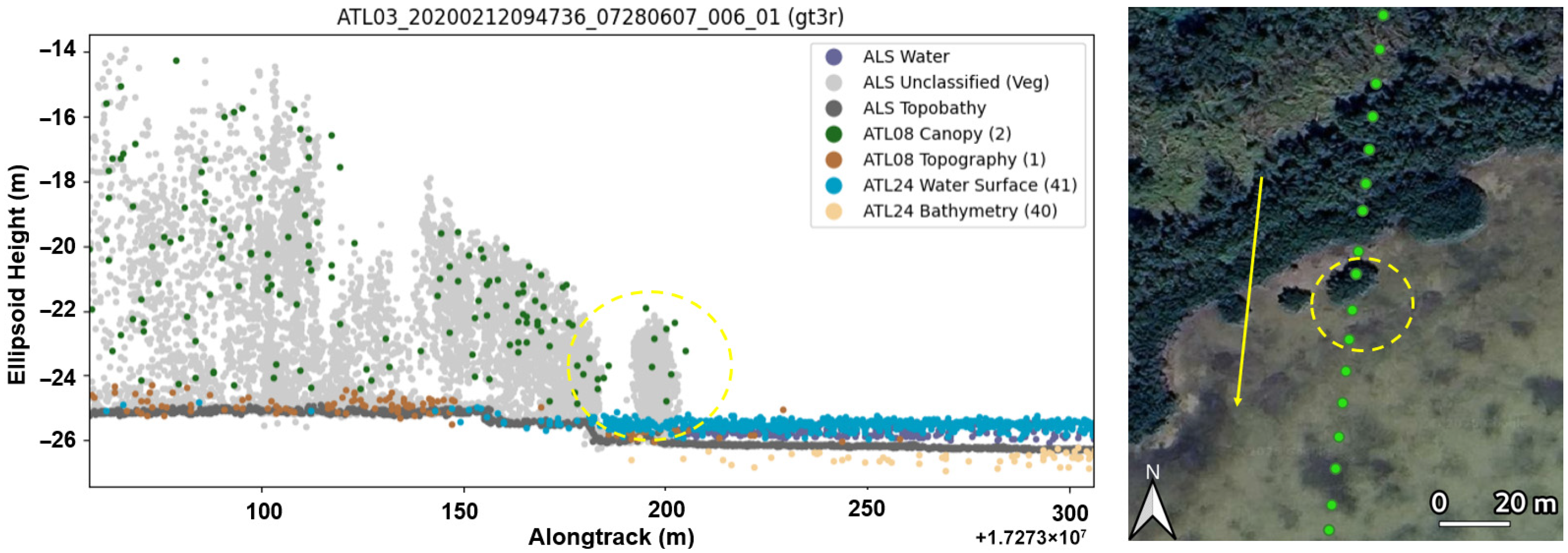
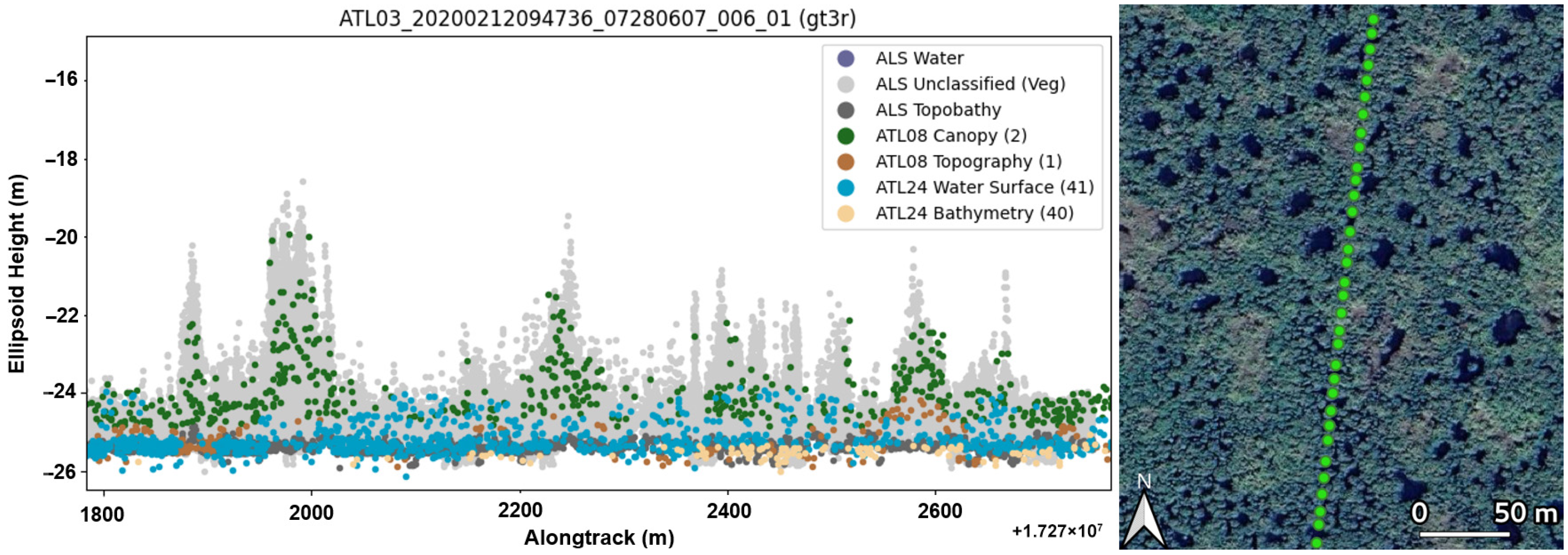
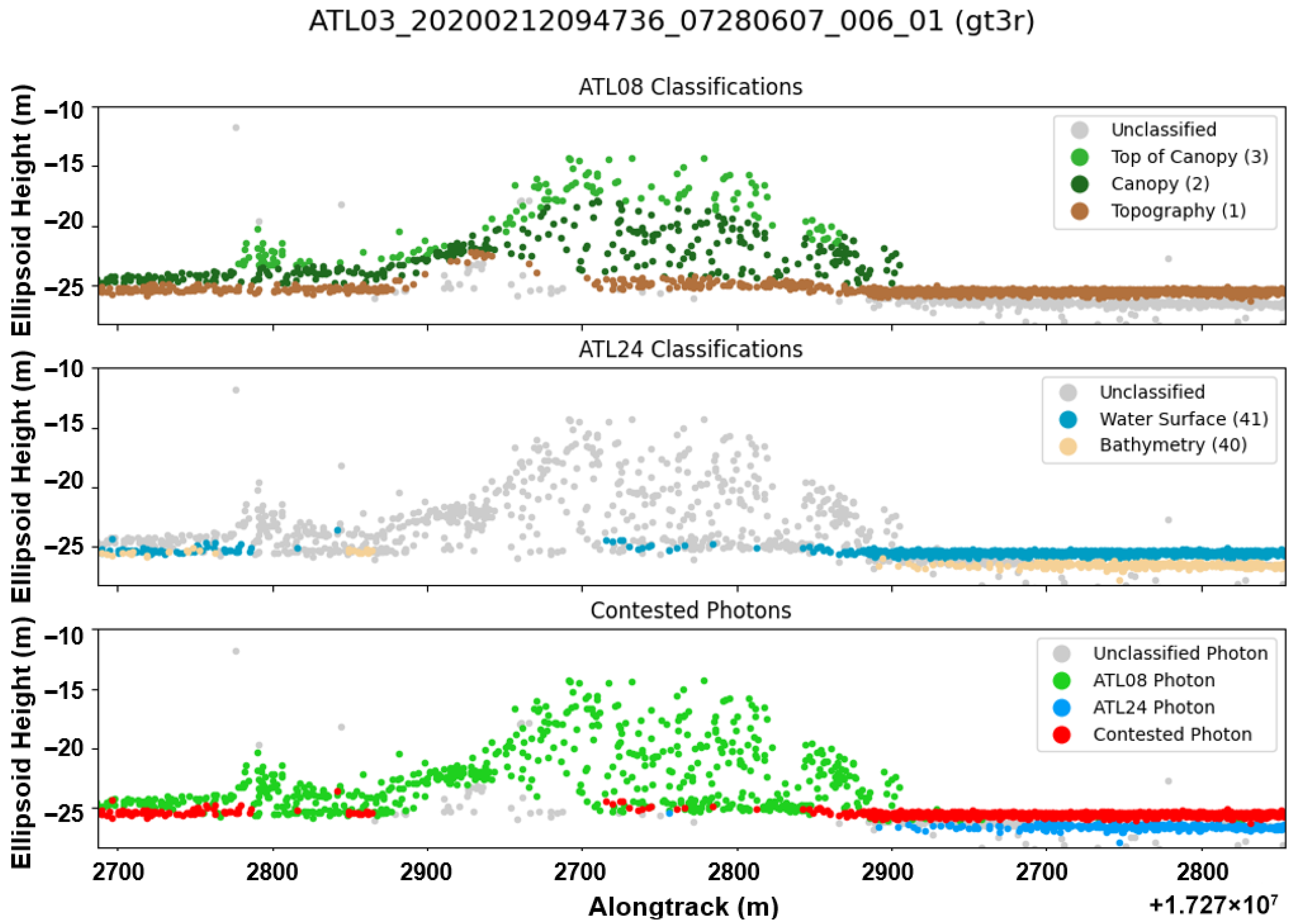
While the measured RMSE for bathymetry and terrain is low, the current ATL08 and ATL24 algorithms do not clearly differentiate between terrain, water surface, and bathymetry. This leads to a large number of contested photons, that is, photons that were classified both by the ATL08 and ATL24 algorithms. With the high number of contested photons between the ATL08 and ATL24 classifications, it is difficult to positively ascertain the difference between terrain, water surface, and bathymetry.
This may be due to insufficient algorithm tuning in these areas, lack of cross-product communication, and the complexity of mangrove environments. In particular, ATL24 was primarily trained and validated in coastal regions without mangroves. Meanwhile, ATL08 has been known to misclassify water surfaces as terrain and has not been explicitly trained to differentiate between water and terrain in all instances. In highly complex ecosystems such as mangroves, these algorithms struggle to clearly identify changes between terrain and water surface in these relatively flat intertidal zones. This is compounded by both products operating independently of each other, resulting in many contested photons, especially for terrain and water. This ambiguity prevents accurate water depth detection under canopy and could potentially be a cause of this work’s finding of the low 2.5% co-location rate of water under mangrove forest canopies.
4.3. Global Insights: ICESat-2 and GEDI
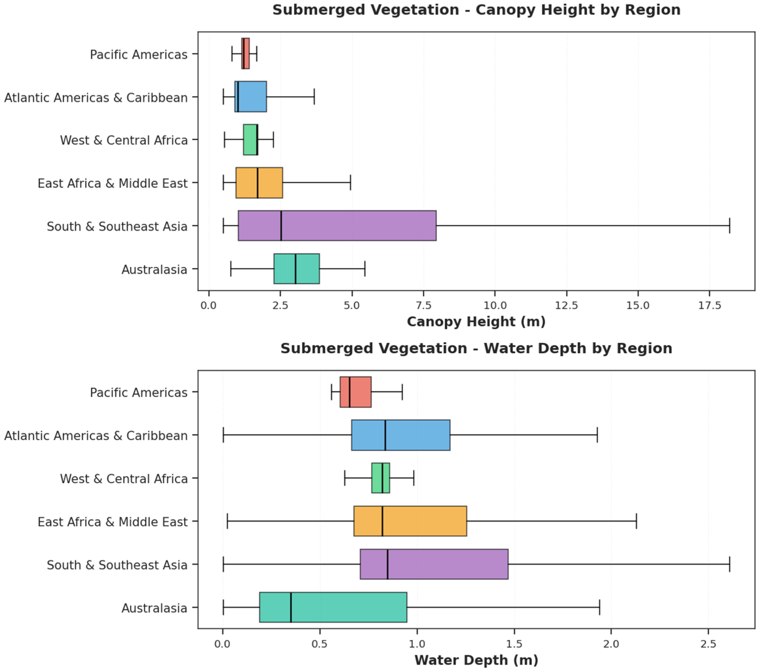
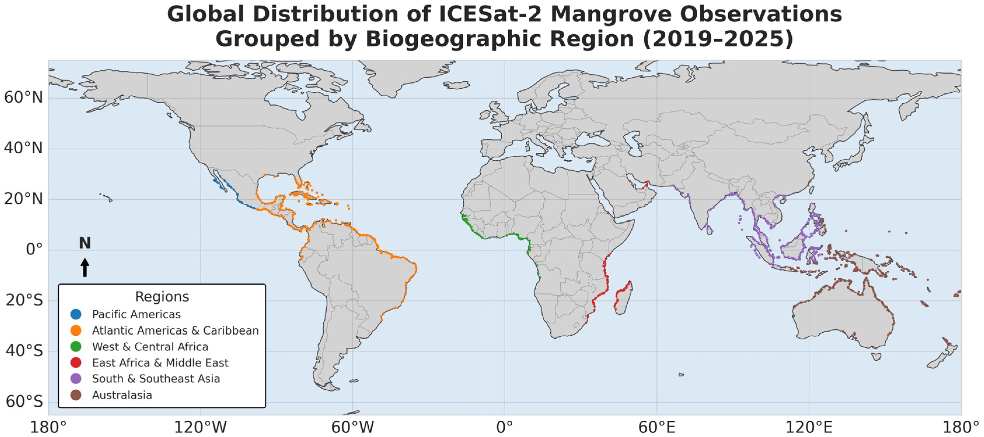
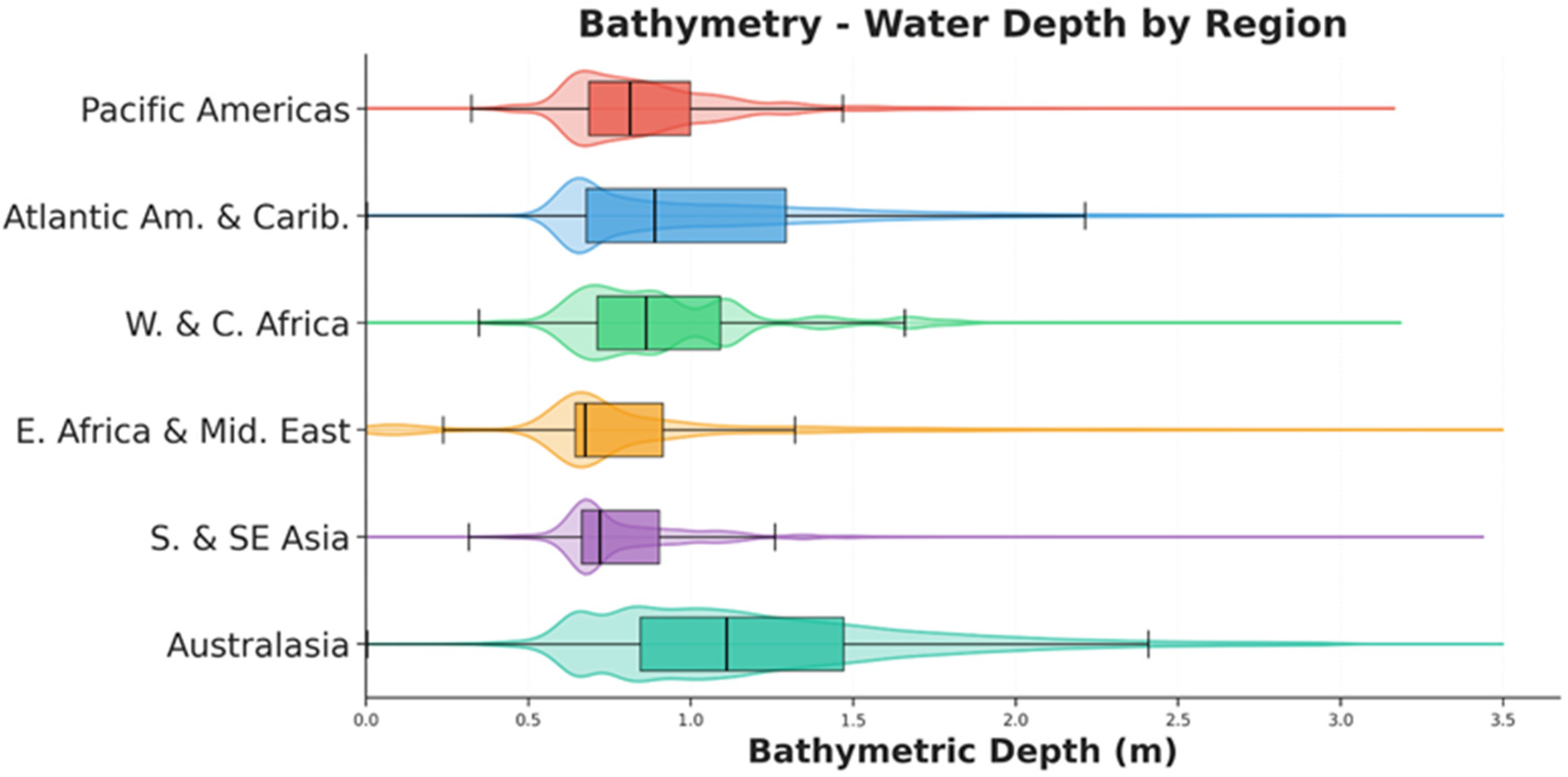
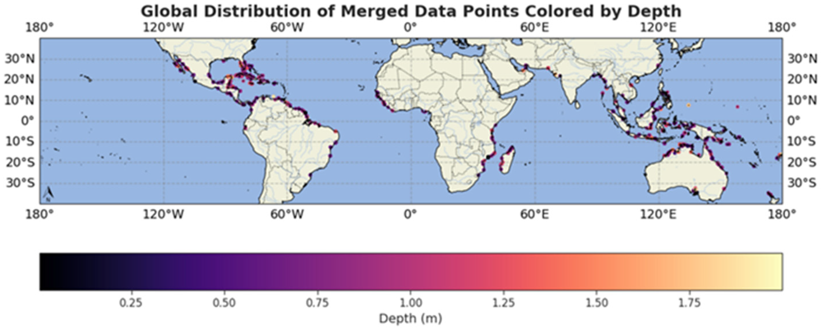
This study found that ICESat-2 can characterize terrain, bathymetry, and canopy structure in global mangrove ecosystems with patterns that both reinforce and extend findings from the Everglades National Park validation. The canopy metrics obtained as night-time, strong beam acquisitions were the most robust globally with highest canopy heights and number of ground photons, indicating good canopy penetration. This is consistent with the Florida analysis. Coastal bathymetry detection yielded consistent shallow water estimates globally around 1 m mean depth. The shallow depth range obtained is not solely dependent on sensor penetration limits. The mangrove mask restricted bathymetric observations to nearshore and mangrove adjacent areas, and these areas can be especially turbid.
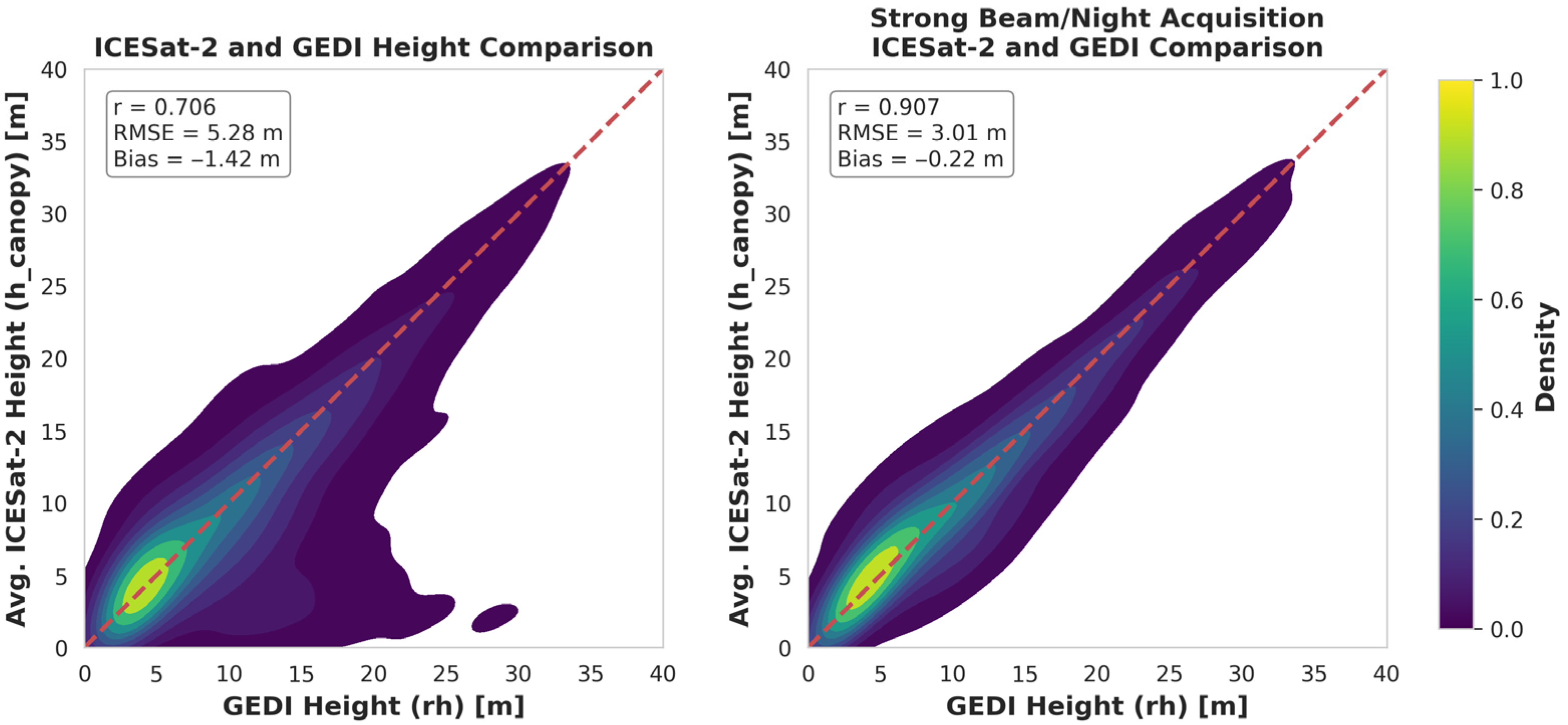
One finding of this work is that ICESat-2 outperformed GEDI when measuring relative canopy heights in the Florida Everglades. Previous research has also established ICESat-2’s superior performance in shorter, shrubby forests in other ecosystems [
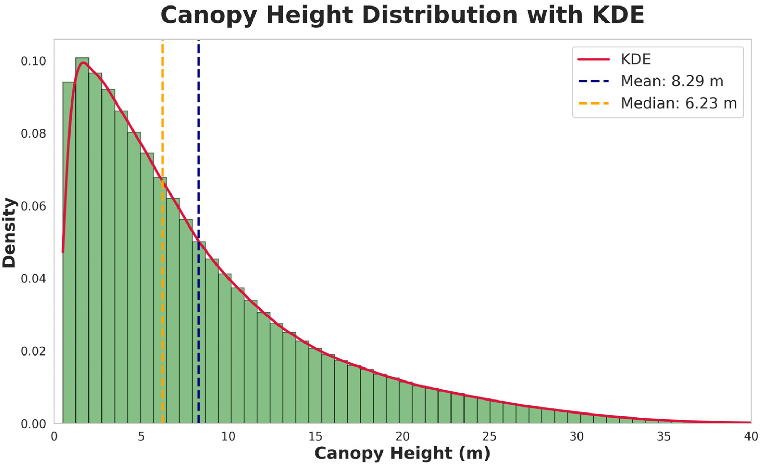
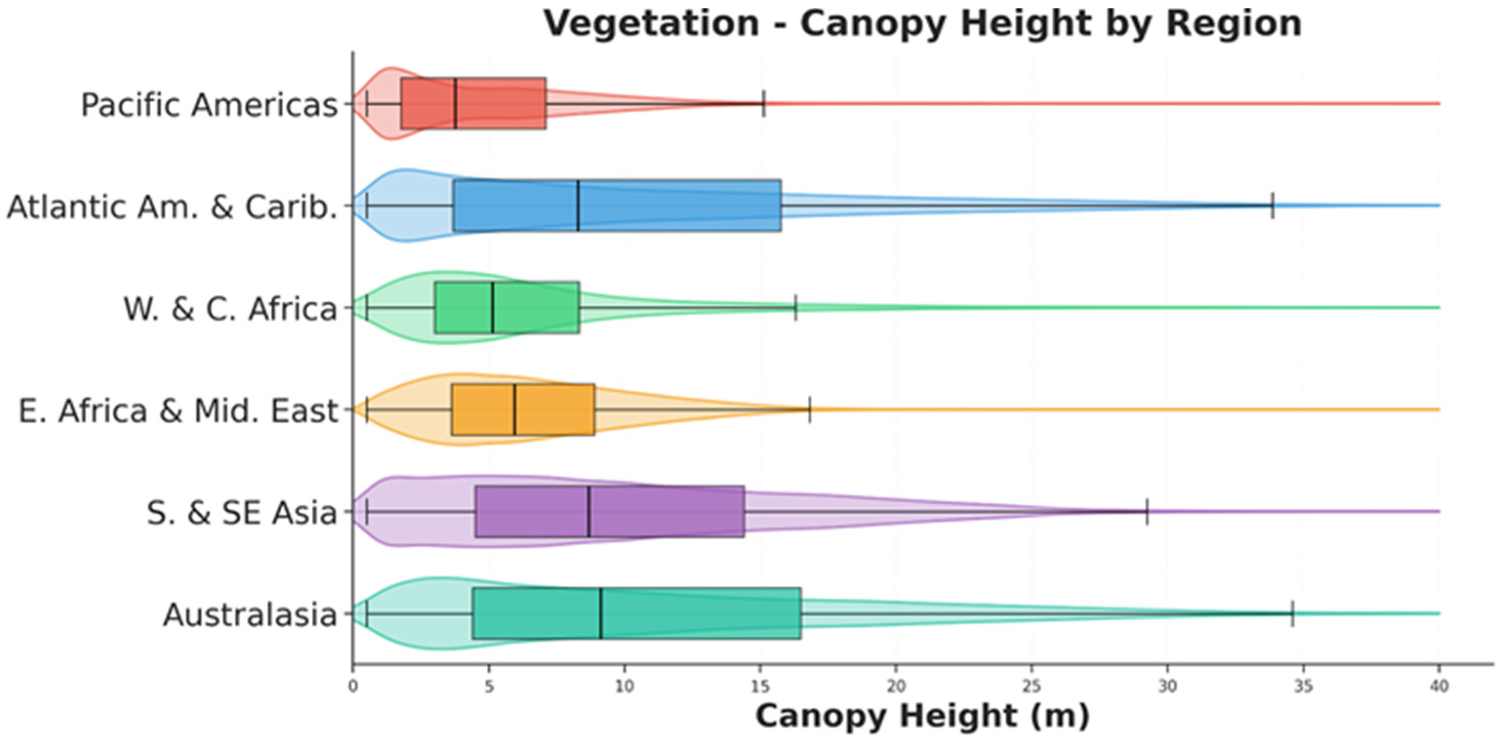
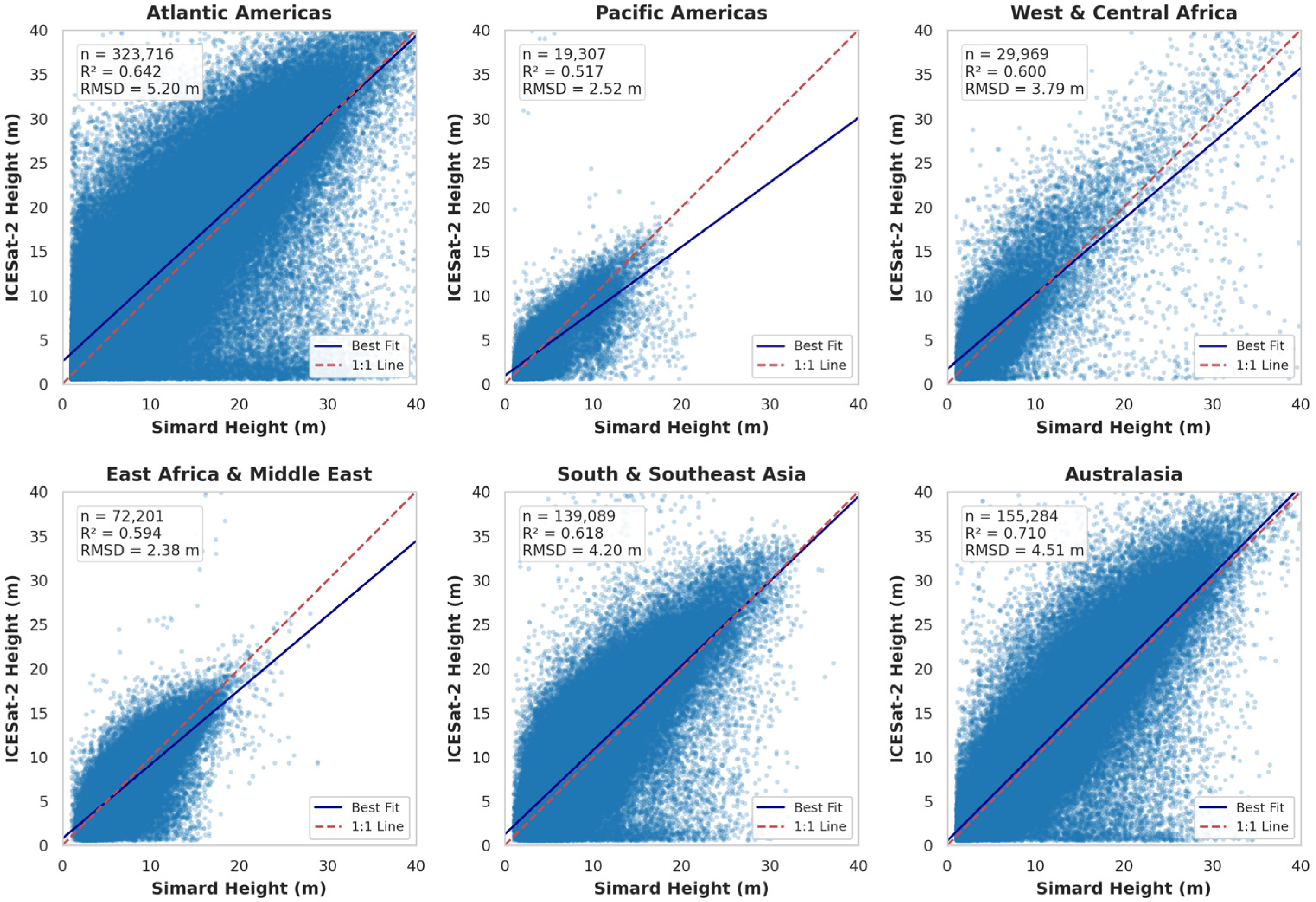
38]. This may be due to ICESat-2 photon counting approach, smaller footprint and higher sensitivity to short vegetation compared to GEDI’s large-footprint waveform, which struggles to resolve short canopies from the ground signal. The global analysis of mangrove canopy heights also found they are mostly short in stature. Globally, mangroves are predominantly short stature, with a mean height of 8.29 m, a median height of 6.23 m, and the largest concentration between 0.5 and 10 m. This height distribution indicates ICESat-2 can be well-suited for mangrove applications. This work suggests that ICESat-2 should be used instead of or in combination with GEDI for certain ecosystems where shorter stature vegetation is present.
This work also demonstrates the limited potential to characterize partially submerged vegetation. While ICESat-2 has been used for surface water monitoring [
39,
40], there is less work for incorporating the bathymetric component in these ecosystems. The global investigation attempted to assess ICESat-2’s ability to determine submerged mangrove root structure; however, only a small number of matched segments (~2.5%) were found with the matched segments being substantially lower canopy heights (3.04 m vs. 8.29 98th percentile heights). The low matching rate could indicate that the current ATL24 algorithm and its confidence filter detects bathymetry predominantly in sparse/low vegetation. In the Florida Everglades validation, for segments with co-located data, the terrain-normalized canopy height (using the ATL08 ground) and the estimated topobathy-normalized canopy height (using the ATL24 bathymetric surface when available) was nearly identical. This suggests that these retrievals occurred in very shallow water, collections coincided with low-tide events, or result from conflicting photon classifications from ATL08 and ATL24.
4.4. Limitations
While this study demonstrates the potential of ICESat-2 for mangrove characterization, several limitations must be considered when interpreting the results, particularly regarding geographic generalizability and tidal dynamics.
First, the regional validation was confined to the Everglades National Park, a decision necessitated by the lack of publicly available, high-resolution topobathymetric airborne lidar in other mangrove regions. The Everglades is a micro-tidal environment with carbonate-based substrates and relatively clear water, representing a “best-case” scenario for bathymetric lidar retrieval. Consequently, the reported accuracy metrics (e.g., 0.25 m bathymetric RMSE) may serve as a benchmark but likely represent an upper bound on performance. Accuracy may degrade in more complex environments common to the Indo-Pacific, which are characterized by macro-tidal regimes, high turbidity, and siliciclastic sediments. Future work should prioritize validation in these diverse settings as coincident topobathymetric lidar or detailed field plots become available.
Second, this analysis did not explicitly model tidal dynamics. For the validation component, ICESat-2 bathymetric elevations were compared directly to the ALS topobathymetric surface relative to the WGS84 ellipsoid. Since bathymetric elevation (the vertical position of the seafloor) is static, the tidal stage does not directly bias this specific validation metric. However, it is important to contextualize the reported bathymetric RMSE of 0.25 m relative to the local tidal regime. The mean tidal range in the study area is approximately 0.76 m [
41]. While ATL24 accounts for the instantaneous sea surface, the lack of explicit tidal modeling means that derived water depths (surface minus refraction-corrected bottom) contain unquantified uncertainty related to the tidal stage at the moment of acquisition. Future studies would benefit from integrating regional tidal models to validate sea surface elevations and refine water depth estimates.
Finally, the potential for detecting submerged vegetation and the detection of prop roots requires cautious framing. In the global analysis, the low rate of co-located bathymetry and canopy data (~2.5%) and the shallow mean depths of matched segments suggest that successful detection is currently limited to sparse canopies in optimal conditions. In other words, the ATL24 classification may be biased to measure water or bathymetry in mangrove forests where it is easier to measure these features, such as mangroves with lower vegetation densities. It is not yet feasible to reliably map submerged structures beneath dense, taller mangrove stands using standard products.
4.5. Future Work
Refining the ATL08 and ATL24 algorithms in determining the difference between water surface, topographic and bathymetric surfaces will greatly enhance accuracy for measuring other characteristics in mangroves, as well as allow for the use of ICESat-2 to detect water and water depths under forest canopies. Differentiating between water surface and terrain will also be useful in other coastal ecosystems where the divide between land and water surface can sometimes be less certain. Identification of the land-water divide could improve shoreline estimates, even in the presence of vegetation. This study represents a first-order assessment, but our findings highlight that the ATL08 and ATL24 algorithms are not yet fully integrated. Resolving the “contested photons” (
Figure 2) and developing a unified land-water-bathymetry classification algorithm are the critical next steps.
Finally, findings with ICESat-2 outperforming GEDI in canopy height estimation suggest more accurate gridded canopy height models. The addition of ICESat-2 and GEDI could provide more accurate maps in addition to providing more high-quality measurements to model training and validation. In the ALS validation, ICESat-2 slightly outperformed GEDI canopy height measurements, while performing comparably to each other in the global analysis. Future global gridded mangrove products using both GEDI and ICESat-2 could benefit both from the inclusion of slightly more accurate canopy height measurements for shorter stature canopies, in addition to the added number of canopy height samples.