Review

Estimating Soil Attributes for Yield Gap Reduction in Africa Using Hyperspectral Remote Sensing Data with Artificial Intelligence Methods: An Extensive Review and Synthesis

1
Center for Remote Sensing Applications (CRSA), Mohammed VI Polytechnic University (UM6P), Ben Guerir 43150, Morocco
2
Analytics Lab (ALAB), Mohammed VI Polytechnic University (UM6P), Rabat 11103, Morocco
3
Department of Geography, Environment & Geomatics, University of Guelph, Guelph, ON N1G 2W1, Canada
4
Department of Geomatic Sciences and Surveying Engineering, Hassan-II Agronomic and Veterinary Institute, Rabat 10101, Morocco
*
Author to whom correspondence should be addressed.
Remote Sens. 2025, 17(9), 1597; https://doi.org/10.3390/rs17091597
Submission received: 7 March 2025 / Revised: 5 April 2025 / Accepted: 14 April 2025 / Published: 30 April 2025

Abstract

:
Africa’s rapidly growing population is driving unprecedented demands on agricultural production systems. However, agricultural yields in Africa are far below their potential. One of the challenges leading to low productivity is Africa‘s poor soil quality. Effective soil fertility management is an essential key factor for optimizing agricultural productivity while ensuring environmental sustainability. Key soil fertility properties—such as soil organic carbon (SOC), nutrient levels (i.e., nitrogen (N), phosphorus (P), potassium (K), moisture retention (MR) or moisture content (MC), and soil texture (clay, sand, and loam fractions)—are critical factors influencing crop yield. In this context, this study conducts an extensive literature review on the use of hyperspectral remote sensing technologies, with a particular focus on freely accessible hyperspectral remote sensing data (e.g., PRISMA, EnMAP), as well as an evaluation of advanced Artificial Intelligence (AI) models for analyzing and processing spectral data to map soil attributes. More specifically, the study examined progress in applying hyperspectral remote sensing technologies for monitoring and mapping soil properties in Africa over the last 15 years (2008–2024). Our results demonstrated that (i) only very few studies have explored high-resolution remote sensing sensors (i.e., hyperspectral satellite sensors) for soil property mapping in Africa; (ii) there is a considerable value in AI approaches for estimating and mapping soil attributes, with a strong recommendation to further explore the potential of deep learning techniques; (iii) despite advancements in AI-based methodologies and the availability of hyperspectral sensors, their combined application remains underexplored in the African context. To our knowledge, no studies have yet integrated these technologies for soil property mapping in Africa. This review also highlights the potential of adopting hyperspectral data (i.e., encompassing both imaging and spectroscopy) integrated with advanced AI models to enhance the accurate mapping of soil fertility properties in Africa, thereby constituting a base for addressing the question of yield gap.

Graphical Abstract

1. Introduction

Ensuring food security for a rapidly growing global population requires sustainable resource management [1]. This is particularly of great importance in African agriculture, where smallholder farmers are facing significant challenges such as low soil fertility, unpredictable rainfall, and unsustainable land use practices [2]. These factors contribute to low crop yields and widespread food insecurity. A crucial element in overcoming these obstacles is the effective understanding and management of soil fertility attributes (soil organic carbon (SOC), nitrogen (N), phosphorus (P), potassium (K), moisture retention (MR), or moisture content (MC) and soil texture), which play a pivotal role in agricultural productivity and serve as a key criterion for reducing the yield gap [3]. The yield gap is defined as the difference between the actual yield currently being achieved by farmers and the potential yield attainable with best agronomy practices [4]. To effectively address this gap, it is imperative to increase our knowledge of the role of soil in African agricultural systems [5]. Such knowledge enables effective soil fertility management and agricultural productivity to reduce the yield gap [6]. However, traditional methods for measuring soil properties generally require complex chemical indicators and laboratory equipment, making them both environmentally unfriendly and expensive [7]. These methods, including in situ soil sampling and laboratory chemical analysis, are costly and time-consuming [8]. Additionally, these methods are limited to specific areas and do not provide spatial data, which is essential for efficiently managing agricultural inputs across extensive fields and varying periods [9]. Therefore, there is a continuous need for innovative approaches that can offer more efficient, cost-effective solutions and continuous spatial information for assessing and managing soil. In this context, remote sensing emerges as a valuable alternative to traditional methods, offering large-scale, timely, and non-destructive data acquisition [10]. Among these remote sensing techniques, multispectral imaging (e.g., Landsat 8, Sentinel 2) has been widely explored for soil property assessment. For instance, several studies have used it to predict key soil fertility characteristics such as cropland soil nutrients [11] and SOM [12]. However, multispectral imaging faces several challenges that can limit its accuracy and applicability in soil assessment, despite its advantages. Factors such as lower spectral resolution compared to hyperspectral imaging and interference from vegetation cover introduce uncertainties in soil property predictions.
With the advancement of hyperspectral Remote sensing technologies, it is now possible to extract more detailed and precise information about soil properties, revolutionizing our ability to monitor and assess Earth’s surface characteristics over large areas [13]. However, a key limitation of optical remote sensing, including hyperspectral imaging, is its restricted ability to capture subsurface soil properties [14]. Since most soil fertility and moisture dynamics extend beyond the surface layer, understanding root-zone conditions remains a challenge. Remote sensing methods, while powerful for surface analysis, often require integration with in situ soil sampling, geophysical techniques (e.g., ground-penetrating radar, electromagnetic induction), or sensor fusion approaches to enhance subsurface characterization [15]. Despite these challenges, hyperspectral remote sensing data have been increasingly applied worldwide to soil science, offering new possibilities for estimating various soil attributes efficiently and non-invasively [16,17]. Moreover, with the emergence of AI, the potential of hyperspectral data for soil assessment has even been further enhanced. For instance, AI-driven methodologies, including machine learning and deep learning algorithms, have significantly improved the accuracy and efficiency of soil property predictions by effectively analyzing complex hyperspectral datasets [18]. This shift is moving away from standard interpolation geostatistical methods (i.e., kriging) as the core algorithm for mapping and toward more advanced AI-based spatial prediction techniques [19]. Consequently, several studies have explored the integration of AI with hyperspectral data. Specifically, machine learning techniques, including various regression algorithms, have been employed to predict key soil attributes with high precision. For instance, Vibhute and Kale [20] successfully applied hyperspectral data in soil type mapping, leveraging advanced machine learning methods such as Support Vector Machines (SVMs) and Partial Least Squares Regression (PLSR) to achieve high classification accuracy. Meanwhile, Divya et al. [21] focused on soil property estimation using machine learning-based regression techniques and demonstrated the effectiveness of Random Forest (RF) and Gradient Boosted Regression Trees (GBRTs) in predicting soil fertility indicators such as organic matter, moisture content, and macronutrient concentrations. However, these models rely on manual features and struggle to capture complex spectral relationships. Deep learning models have been introduced to address these limitations, significantly improving predictive accuracy by learning hierarchical spectral representations. For instance, Zhong et al. [22] used Deep Convolutional Neural Networks (DCNNs) to predict soil properties using the LUCAS soil spectral library, achieving higher R2 values (0.95 for OC, 0.93 for N, and 0.96 for CaCO3) compared to traditional methods. While this model improved feature extraction, their reliance on localized receptive fields limited their ability to capture long-range spectral dependencies, necessitating the shift towards self-attention-based architectures. More recently, Cao et al. [23] introduced a transformer-CNN hybrid model, integrating global attention from transformers with local feature extraction from CNNs, leading to a 10–24 percentage point improvement in R2 over traditional methods. The model achieved high accuracy (R2 = 0.94–0.96) in predicting pH, organic carbon (OC), nitrogen (N), and calcium carbonate (CaCO3), demonstrating the efficiency of hybrid deep learning architectures. While hyperspectral data combined with AI has demonstrated excellent predictive performance on controlled spectroscopy setups and curated spectral libraries such as LUCAS, challenges remain in translating these high accuracies to real-world scenarios. The shift from laboratory conditions to field-based hyperspectral imaging presents several issues, including variable lighting, atmospheric interference, and heterogeneous soil textures, which can degrade model performance. Several recent studies have focused on addressing these challenges, exploring methods to adapt hyperspectral AI models for real-world field conditions achieving moderate to good metrics for different soil properties.
Despite these advancements in hyperspectral remote sensing, particularly with the increasing availability of freely accessible hyperspectral satellite data (i.e., PRISMA, EnMAP, DESIS), their application remains underexplored in African countries. Most studies have relied on multispectral images or laboratory spectroscopy, which can be attributed to the high complexity of processing hyperspectral images and the computational resources required [24,25]. However, only a few studies have demonstrated the potential of hyperspectral remote sensing for soil property estimation [26,27,28], highlighting the need for further research in this region. Indeed, while these studies successfully combined hyperspectral data with machine learning, they often lack the integration of cutting-edge deep learning architectures, such as transformers and foundational AI models, which have demonstrated remarkable improvements in hyperspectral analysis [29]. These advanced models can capture long-range dependencies, enhance spatial–spectral feature extraction, and improve generalization across diverse soil conditions, making them crucial for scaling soil property estimation hyperspectral-based in data-scarce environments like Africa.
The main goal of this study is to show the capabilities of hyperspectral technology and advanced AI methods, which offer immense potential. However, substantial innovation is needed on the part of African scientists to transform the data collected into practical tools for soil mapping using hyperspectral remote sensing and their potential to close the yield gap. To this end, our objectives are to (i) provide an overview and state of the art of current methodologies used for soil property estimation, including remote sensing and AI-based approaches; (ii) assess the adoption of these methodologies in Africa, comparing their implementation and success to studies conducted on a global scale; (iii) evaluate the advantages of AI-integrated remote sensing in the African agricultural context, particularly in improving soil fertility properties assessment necessary for yield closing; and (iv) propose recommendations and future perspectives, emphasizing the need for greater access to hyperspectral remote sensing data, computational infrastructure, and AI expertise while advocating for foundational AI models tailored to African soil conditions.

2. Synthesis of Previous Published Reviews

Agricultural research utilizing hyperspectral remote sensing and AI methods for soil property estimation has grown significantly, necessitating a comprehensive survey to track advancements and innovations in this domain. Several reviews have been published on using remote sensing techniques for soil analysis. For instance, Barra et al. [7] provided an extensive overview of integrating mid- and near-infrared spectroscopy with chemometric and machine learning approaches for soil property diagnosis. Their study highlighted preprocessing techniques, such as smoothing and normalization, which improve spectral data quality. They emphasized the importance of robust calibration models, such as PLSR and SVM Regression, in enhancing prediction accuracy for key soil attributes like organic carbon and nutrient levels. Similarly, Piccini et al. [30] presented a review of proximal soil sensing techniques using visible and near-infrared (Vis-NIR) spectroscopy for in-field soil analysis. Their findings underscored the growing adoption of proximal sensing tools for rapid soil diagnostics. They identified key challenges, such as the impact of soil moisture and variability in field conditions, while recommending the harmonization of field and laboratory calibration datasets to improve measurement accuracy. This review was complemented by a recent work [31], which explored the evolution of soil spectroscopy from benchtop systems to mobile platforms, emphasizing the advancements in portability and cost-effectiveness. Their study highlighted the application of machine learning models, including Random Forest (RF) and Artificial Neural Networks (ANNs), for processing soil spectral data. While the review emphasized precision agriculture applications, it also identified limitations in model generalizability across diverse soil types and environments.
Although these reviews provide insights into the integration of proximal spectroscopy and AI in soil science. Few studies in the literature have conducted a detailed examination of hyperspectral imaging (HSI) and its unique contribution to soil property assessment. Chabrillat et al. [32] reviewed the application of hyperspectral spectroscopy for soil mapping and monitoring using airborne and spaceborne sensors. They highlighted the potential of future hyperspectral missions such as PRISMA, EnMAP, and HISUI to provide high-precision global data. However, they identified gaps in spectral libraries and processing methods necessary to exploit these technologies fully. Abdulraheem et al. [10] provided an overview of remote sensing techniques, including spectral, thermal infrared, and radar analyses. They emphasized the combined use of data for soil property mapping and identified challenges such as the need for robust calibrations and the integration of AI to improve accuracy. Although these studies showed significant advancements in hyperspectral imaging and remote sensing, they lack a detailed discussion of recent AI developments and advancements in remote sensing sensors. In this context, Janga et al. [18] provide a global review of practical AI applications in remote sensing, highlighting the role of AI and diverse remote sensing sensors, such as LiDAR, hyperspectral, and radar, across various agricultural fields. Their comprehensive analysis underscores how AI methodologies, including deep learning and ensemble techniques, revolutionize tasks like land cover mapping, object detection, and data fusion. The study also addresses challenges such as data quality, computational resources, and model interpretability while proposing advancements in integrating AI and remote sensing technologies to enhance agricultural decision-making.
However, most existing reviews focus on applying remote sensing for soil analysis and digital soil mapping (DSM) [9,33,34,35,36] or using AI methodologies in isolation. When the integration of these two fields is discussed, it is often framed in a general agricultural context [37,38] without focusing specifically on soil studies. Furthermore, detailed examinations of hyperspectral remote sensing sensors and the associated advanced AI methodologies for soil assessment are typically absent. This review aims to address these gaps by providing a comprehensive analysis of hyperspectral data across diverse platforms (spaceborne, airborne, UAV) and AI methodologies, from traditional machine learning models like PLSR, RF, and SVM to advanced techniques such as CNNs, RNNs, attention-based architectures, transformers, and foundation models tailored for soil property evaluation.

3. Overview of Remote Sensing Techniques and Quantitative Methods Used for Soil Properties Estimation

The combination of remote sensing and AI has revolutionized soil property mapping, shifting from classical interpolation-based geostatistical models (i.e., IWD, Kriging, and Cokriging) to spatially explicit, data-driven approaches. While RS provides high-resolution spectral and spatial data, AI enhances pattern recognition, predictive accuracy, and automation in soil analysis.
In the following sections, we first provide an overview of RS sensors, covering multispectral, hyperspectral, and spectroscopy-based techniques, highlighting their capabilities for soil property estimation. Next, we discuss the progression from traditional machine learning methods (e.g., RF, SVM) to advanced AI approaches such as deep learning and transformer models, emphasizing their role in enhancing prediction accuracy and handling high-dimensional hyperspectral data. Finally, we examine how these technologies reshape soil assessment, enabling precision agriculture, sustainable land management, and improved environmental monitoring.

3.1. Remote Sensing Sensors Used for Soil Properties Estimation

Among the widely employed RS techniques, multispectral and hyperspectral imaging have been highly effective for soil studies. While multispectral imaging records spectral signals in discrete bands, hyperspectral imaging offers higher spectral resolution, providing continuous narrow bandwidths (<10 nm) that enable more detailed chemical and physical soil property assessment [39,40]. This fine spectral resolution enhances the differentiation between various soil attributes, making hyperspectral imaging particularly valuable for soil composition analysis.
Furthermore, remote sensing platforms—including satellites, airborne systems, and UAVs—offer varying advantages, each contributing to different scales of soil assessment. Specifically, satellites provide extensive coverage, making them ideal for regional-scale monitoring, whereas airborne and UAV sensors offer high-resolution, localized assessments crucial for detailed soil analysis. Notably, UAV-mounted hyperspectral sensors have further enhanced cost-effective, high-precision soil analysis, bridging the gap between large-scale satellite observations and fine-scale field measurements.
With advancements in hyperspectral technology, the integration of spectroscopy-based proximal sensing, spaceborne sensors, and airborne platforms has further improved soil characterization. The following sections thoroughly explore these technologies, emphasizing their capabilities, applications, and limitations in modern soil monitoring.

3.1.1. Spectroscopy-Based Proximal Soil Sensing

Proximal soil sensing (PSS) refers to the use of ground-based sensors to collect data on soil properties at proximity (i.e., within 2 m [17]) or in direct contact with the soil [41]. These sensors, which can be either active or passive, provide physical or chemical information, often in real time, to assess properties such as texture, organic matter content, or soil moisture [17]. Unlike remote sensing, PSS focuses on precise, localized measurements, that can sometimes be integrated into mobile systems (i.e., vehicles) for fine-scale, georeferenced mapping [42]. It is a non-destructive, rapid, and adaptable tool suited to field conditions [43]. Among the techniques in PSS, soil spectroscopy plays a pivotal role due to its fast, cost-effective, and environmentally friendly characteristics. Soil spectroscopy serves as an alternative to traditional wet chemistry by leveraging the interaction of electromagnetic radiation with soil components across different spectral regions to assess key soil properties [44]. This interaction enables the detection of key soil properties, making spectroscopy an invaluable tool for enhancing the precision and efficiency of proximal soil sensing systems.
Among the most commonly employed methods, VIS-NIR spectroscopy (400–2500 nm) and MIR spectroscopy (2500–25,000 nm) are the most employed spectroscopic techniques, allowing the prediction of a wide range of soil attributes such as SOC [37,38], clay content [45,46], pH [47,48], salinity [49], total nitrogen (TN) [50,51], and other soil properties. These methods have distinct advantages over conventional laboratory-based soil analyses. They enable the simultaneous estimation of multiple soil properties from the same sample, eliminating the need for numerous sub-sample analyses that can introduce variability due to micro-heterogeneity. Additionally, spectroscopy avoids the use of chemical reagents, making it both cost-effective and environmentally friendly [52]. However, laboratory-based VIS-NIR and MIR spectroscopy often require significant sample preparation, including drying, grinding, and sieving, to minimize the effects of soil moisture and roughness to ensure accurate predictions [53]. Despite these requirements, MIR spectroscopy has demonstrated superior accuracy in calibrating soil properties compared to VIS-NIR [54].
Nevertheless, MIR spectrometers are less accessible for field applications due to their high cost and limited portability. In contrast, VIS-NIR spectroscopy offers notable advantages for field use, including the availability of portable spectroradiometers (e.g., ASD FieldSpec, Malvern Panalytical, Malvern, UK) that can tolerate wet and heterogeneous samples. Recent developments in low-cost portable NIR devices have further expanded accessibility, though these devices often feature limited wavelength coverage, affecting the precision of property estimations [55,56]. Despite its strengths, the interpretation of spectral data remains complex. For instance, SOM, a key determinant of soil color and fertility, exhibits spectral absorption patterns that can overlap with other soil components, complicating analysis [57]. Properties like soil pH, CEC, and nutrient levels do not have direct spectral responses but can be estimated indirectly through their correlations with spectral properties such as SOM, clay, and carbonates [58]. The integration of VIS-NIR and MIR spectra has shown promise in enhancing predictive accuracy by combining the complementary strengths of these spectral regions. This fusion allows for a more comprehensive assessment of soil properties, leveraging the detailed absorption features captured by both VIS-NIR and MIR spectrometry [54,59]. Indeed, VIS-NIR and MIR spectroscopy are the most used ground reference reflectance, but during the last year, several other spectroscopy techniques such as X-Ray Fluorescence (XRF) [60], Fourier-Transform Infrared (FTIR), Laser-Induced Breakdown Spectroscopy (LIBS) [61], and others [62], are gaining more attention. Each method leverages specific interactions between electromagnetic radiation and soil components to extract detailed information about soil properties, offering unique strengths and applications in soil attribute estimation.

3.1.2. Imaging Spectroscopy

Imaging Spectroscopy (IS) combines the advantages of imaging and spectroscopy, providing detailed and spatially explicit spectral information across various scales. This technology represents a significant advancement over point spectrometry by integrating spectral data into a spatial context, thereby enhancing the analysis of soil properties under diverse field conditions. By utilizing sensors ranging from satellites to ground-based devices, IS enables the examination of pedological processes with greater accuracy while overcoming the limitations of traditional techniques [63].
In precision agriculture, IS plays a crucial role in delivering qualitative and quantitative indicators of soil health and fertility. This technology allows for the assessment of fields before, during, and after the growing season by identifying spatial variability in soil properties for optimal resource management. For instance, hyperspectral imaging, a subset of IS, captures hundreds of contiguous spectral bands, facilitating detailed analyses of soil chemistry, mineralogy, and physical properties [64]. The integration of IS with advanced tools, such as machine learning, paves the way for significant improvements in soil monitoring and management [65], contributing to closing yield gaps and promoting sustainable agricultural practices.
In the subsequent sections, we detail the role of spaceborne imaging spectroscopy in global-scale soil analysis and airborne and UAV-based imaging spectroscopy, which enable finer spatial resolutions for localized applications.

Spaceborne

Satellite-based remote sensing imagery has emerged as a valuable tool for generating spatial maps of the upper soil layer. This capability is attributed to the established correlations between soil-specific chemical properties and their interactions with electromagnetic radiation [33]. Optical multispectral imagery (e.g., Landsat 8, Sentinel-2, RapidEye) has been widely employed for the quantitative assessment of soil fertility and related properties. Since the introduction of free access to Landsat data in 2008 [66], multispectral satellites have gained popularity due to their high spatial coverage and frequent revisit times. These attributes have facilitated mapping key soil fertility properties at multiple scales.
Despite these advantages, multispectral sensors are limited by their spectral resolution, which can reduce the accuracy of retrieved variables. Hyperspectral spaceborne sensors, offering hundreds of narrow spectral bands, capture detailed spectral responses that allow for greater precision in soil property mapping [67]. Studies have consistently demonstrated that hyperspectral imaging accurately surpasses multispectral sensors when mapping soil parameters [13]. However, the adoption of hyperspectral imaging in operational agriculture has been constrained by factors such as the high cost of sensors and missions, low signal-to-noise ratios, the large data volumes required for processing [37], and atmospheric attenuation that influences the spectral signals [32].
Multispectral satellite data can also act as auxiliary variables for soil property mapping. Research shows that the integration of hyperspectral imaging and time-series multispectral imagery provides complementary solutions, especially for estimating SOC stocks in low-relief agricultural regions [68]. Hyperspectral images, with their high spectral resolution, yield precise insights into soil properties, and their integration with covariates derived from multispectral sensors, digital elevation models (DEM), and vegetation indices has been shown to significantly enhance mapping accuracy [14,69]. Covariates such as slope, aspect, elevation, and indices like NDVI capture critical spatial and temporal variations essential for predicting soil attributes.
Free-access hyperspectral satellites, such as EO-1 Hyperion, PRISMA, and EnMAP (e.g., 220, 239, 230, respectively), have played key roles in advancing soil science research. Hyperion, operational from 2000 to 2017, enabled groundbreaking studies, such as diagnosing nutrient deficiencies, and assessing environmental risks posed by soil parameters [70]. Other studies used Hyperion data to develop spectral models for estimating soil parameters related to nutrient and organic matter turnover in subtropical wetlands [71], in a separate study the authors [72] compared Hyperion performance against multispectral imagery for soil fertility estimations.
Recent advancements, particularly through PRISMA (launched in 2019) and EnMAP (launched in 2022), have significantly enhanced soil property mapping. These sensors offer data in the VisNIR, and shortwave infrared ranges with a continuous number of bands over the 400–2500 nm spectrum and a spatial resolution of 30 m. Detailed characteristics of these and other hyperspectral sensors are summarized in Table 1.
Both PRISMA and EnMAP have been widely used for monitoring soil variability, with studies demonstrating their potential for applications such as estimating SOC and texture in fire-impacted Mediterranean landscapes [73] and improving soil property predictions through enhanced spatial resolution and atmospheric corrections [74]. Advanced techniques, such as scalable neural architectures, have been developed to estimate soil properties using PRISMA’s hyperspectral data [75], while EnMAP has been applied to map iron oxide, clay, and SOC with higher precision than multispectral imagery [76]. Although PRISMA and EnMAP provide high-quality data for soil studies, their spatial resolution (30 m) remains a limitation for precision agriculture, where finer details are essential for nutrient estimation and soil health assessments. Commercial hyperspectral satellites, while offering higher resolutions, remain cost-prohibitive for widespread agricultural applications. National research-focused satellites, such as HysIS [77] and HISUI [78], Ziyuan-1 02D [79], are limited in scope, further constraining their application in precision agriculture.
However, the increasing deployment of commercial satellites, such as TRUTHS (Traceable Radiometry Underpinning Terrestrial and Helio-Studies) and PIXXEL, along with the emergence of new research satellites such as PRISMA2GEN, is likely to enhance competition in the market. This competition is expected to improve both the accessibility and affordability of high-resolution satellite data. The growing availability of such data holds the potential to unlock new opportunities for precision agriculture and soil attribute mapping, addressing existing limitations and facilitating broader adoption of these technologies for an accurate yield gap analysis.

Airborne and Unnamed Arial Vehicles (UAV’s) Data

Airborne and UAV-based hyperspectral imaging have emerged as essential technologies in soil science, bridging the gap between ground-based proximal sensing and satellite remote sensing. These platforms provide a unique combination of high spatial, spectral, and temporal resolution (Table 2), enabling precise soil attribute estimation at scales suitable for both localized studies and broader regional assessments.
Airborne platforms, such as AVIRIS (Airborne Visible/Infrared Imaging Spectrometer), which delivers calibrated images in 224 contiguous spectral channels spanning wavelengths from 400 to 2500 nm [80], and CA SI (Compact Airborne Spectrographic Imager), which provides a spectral resolution of 288 bands at 1.9 nm intervals across 400–1000 nm [81], are frequently used for large-scale soil monitoring. Similarly, APEX (Airborne Prism Experiment) records hyperspectral data in approximately 300 bands across the wavelength range of 400–2500 nm with a spatial ground resolution ranging between 2 m and 5 m, enabling high-precision analysis [82]. HySpex airborne systems are known for their high resolution, speed, low weight, and power efficiency, making them ideal for airborne hyperspectral data acquisition. Additionally, Specim AISA systems [83] produce high-quality hyperspectral images with precise, calibrated ground coordinates. AISA systems cover the VNIR (380–1000 nm), SWIR (1000–2500 nm), and thermal LWIR (7.7–12.3 µm) spectral ranges, and are ruggedized for airborne, ensuring durability and reliability in challenging environments. Equipped with advanced hyperspectral imaging systems, these sensors capture a wide range of spectral bands sensitive to map soil properties like organic matter [84], clay content [85], and SOC [86,87], facilitating the development of detailed soil maps. However, the acquisition of such high-quality data requires significant investment in aircraft operations, advanced sensor technology, and the extensive processing of large data volumes.
On the other hand, unlike traditional airborne systems, Unmanned Aerial Vehicles (UAVs), commonly referred to as drones, have transformed remote sensing with their operational flexibility, cost-effectiveness, and capacity to capture ultra-high-resolution imagery and site-specific soil analysis [88]. Equipped with multispectral or hyperspectral sensors, UAVs provide data at resolutions capable of detecting subtle variations in soil conditions, often overlooked by larger-scale sensing systems. UAV-based systems have been effectively applied to soil nutrient mapping [89], soil texture estimation [90], soil organic matter monitoring [91], and analyzing nutrient and sediment flow pathways in agricultural fields [92]. These studies demonstrate the versatility and precision of UAV imaging spectroscopy in capturing fine-scale spatial variability in soil properties while addressing challenges like atmospheric interference and cloud coverage. However, UAVs face several challenges which make soil properties mapping understudied using this platform. Strict flight regulations often limit their operational altitude and range, while short battery life reduces flight duration [93], especially when using energy-intensive hyperspectral sensors. Additionally, issues like instability caused by wind and limited payload capacity restrict the size and type of sensors they can carry. In addition, data processing remains another challenge, as large data volumes require advanced software and preprocessing to ensure accuracy [94].
Spaceborne systems, when combined with high-resolution airborne and UAV data, these systems enable a multi-scale approach for soil property mapping. Airborne and UAV platforms can serve as validation and calibration tools for spaceborne observations, improving the accuracy of large-scale key soil fertility properties influencing the yield.

3.2. AI Methods for Soil Property Estimation

AI has transformed many disciplines with effective tools for solving complex problems. In medicine, AI increases the accuracy of diagnosis and personalizes treatment methods by interpreting large datasets including medical images and patients’ records [95]. In hydrology, it enhances water resource management and the modeling of hydrological phenomena [96,97]. Likewise, in agriculture, AI has deepened the analysis of data collected through remote sensing. Applications include yield prediction [98], crop mapping [99,100], and estimation of crop evapotranspiration [101]. Furthermore, in soil science, AI enables the prediction and mapping of key and complex soil attributes that are essential for sustainable crop production and soil health management. The latter enables the analysis of high-dimensional datasets, such as those derived from hyperspectral remote sensing, and captures intricate spatial, spectral, and temporal patterns. The forthcoming sections will explore traditional machine learning approaches, advanced deep learning techniques, and the emerging foundational models. These AI-driven methodologies offer new opportunities for modeling soil properties with unprecedented accuracy, thereby advancing our understanding and management of soil characteristics for bridging the yield gap.

3.2.1. Traditional Machine Learning

Traditional machine learning models have been foundational in integrating AI into soil attribute analysis. These models are especially valued for their ease of implementation, interpretability, and efficiency with relatively small datasets. Early on, machine learning approaches showed their utility in addressing the complexity of hyperspectral data analysis, paving the way for more advanced methodologies. However, before applying these models, preprocessing techniques play a crucial role in enhancing their effectiveness.
Hyperspectral data, despite their richness, often exhibit high redundancy and non-informative bands depending on the parameters to predict, making direct analysis challenging. Consequently, preprocessing steps such as data cleaning (e.g., Savitzky–Golay (SG), Multiplicative Scatter Correction (MSC)), normalization, and dimensionality reduction are indispensable for improving analytical efficiency. Classical methods like Principal Component Analysis (PCA) [102], Linear Discriminant Analysis (LDA) [103], and Wavelet Transform [104], are frequently employed to extract relevant spectral information. Additionally, feature selection methods have demonstrated their importance in soil studies, as they refine the analysis by isolating the most significant spectral bands. Furthermore, feature selection methods such as Recursive Feature Elimination (RFE) [105], and Genetic Algorithms (GAs) [106], have been widely adopted to refine the analysis by identifying the most significant spectral bands. These feature selection techniques help mitigate overfitting and enhance predictive accuracy by isolating the most relevant variables for soil property estimation [107]. For instance, Misbah et al. [26] leveraged ensemble learning methods to identify optimal spectral bands for soil total nitrogen estimation, while Laamrani et al. [108] applied an ensemble multimethod modeling approach to select key spectral bands sensitive to SOC content, emphasizing the role of feature selection in addressing redundancy in hyperspectral datasets. These preprocessing techniques set the stage for the application of machine learning models by optimizing the data input.
Among the most effective machine learning algorithms for hyperspectral data analysis, PLSR, SVM [109], and Random Forest (RF) [110], have emerged as powerful tools. These models efficiently process many variables, including spectral reflectance, to extract meaningful insights and patterns from high-dimensional datasets.
PLSR is among the common statistical techniques in remote sensing, mainly because of its ability to handle high-dimensional and multicollinear datasets. Given that hyperspectral data often include numerous highly correlated spectral bands, traditional regression methods struggle to extract meaningful relationships. However, PLSR effectively tackles these issues by reducing the dimensionality of the predictor space while optimizing the covariance between predictor and response variables [111]. A significant advantage of PLSR is its ability to identify latent variables—linear combinations of the initial spectral bands—that exhibit the highest predictive power for the target variables. This feature not only enhances the interpretability of hyperspectral data but also increases computational efficiency [112]. Notably, PLSR has been successfully applied to estimate soil properties such as organic carbon, nitrogen, clay, and calcium carbonate in Mediterranean soils from Southern Italy using visible and near-infrared (vis–NIR) spectroscopy [113].
Furthermore, RF, an ensemble-based algorithm utilizing decision trees, employs a bagging (Bootstrap Aggregation) method [110]. This approach involves generating multiple Decision Trees by randomly sampling both data instances and features from the training dataset. By aggregating the outputs of these trees, RF achieves robust predictive performance while providing feature importance, making it particularly suitable for remote sensing applications [114]. Additionally, RF effectively ranks and filters out irrelevant features [115], thereby reducing dimensionality and pinpointing the most informative spectral bands [116]. This selective feature process mitigates overfitting, enhances generalization, and decreases computational load [117]. Nevertheless, accurately identifying discriminative variables from high-dimensional hyperspectral data remains complex, and the choice of training data significantly impacts outcomes. Various RF-based feature selection methods have been developed to address this challenge. For example, the Regularized Random Forest (RRF) algorithm identifies a minimal optimal set of relevant features, effectively removing non-relevant ones [118]. Similarly, the Geographical Random Forest (GRF) extends the traditional RF algorithm by incorporating spatial heterogeneity, a critical aspect in remote sensing applications [119]. RF has exhibited excellent performance in various soil attribute studies. For instance, in Morocco, RF successfully prioritized feature importance in predicting SOM, potassium (K2O), and phosphorus (P2O5), revealing that cation exchange capacity (CEC) and texture were the most crucial variables for SOM prediction [120]. Additionally, RF combined with External Parameter Orthogonalization (EPO) outperformed PLSR models in SOC prediction, improving accuracy by 7% and reducing error by 0.86 g kg−1 [121].
Similarly, SVM has been widely used in machine learning applications for remote sensing due to its strong performance in classification and regression tasks. Its ability to handle high-dimensional data and capture complex, non-linear relationships is particularly advantageous in remote sensing applications. By finding an optimal hyperplane that maximizes the margin between different classes, SVM enhances generalization [122]. The key strength of SVM lies in its kernel-based approach, which maps data into higher-dimensional spaces, enabling linear separation. Commonly used kernel functions, such as the radial basis function (RBF) and polynomial kernels, allow SVM to identify complex patterns in spectral and spatial datasets. Consequently, SVM has been widely applied in land cover classification, vegetation monitoring, soil classification, and soil property estimation [123]. For instance, in the Eastern Indian Himalayas, SVM achieved 93% accuracy in classifying land use/land cover (LULC) types using soil physicochemical properties and 78% with hyperspectral data, outperforming other algorithms like Random Forest and K-Nearest Neighbors [124]. Likewise, in the Three Gorges region of southwest China, SVM with polynomial kernels demonstrated strong reliability in soil texture classification, achieving 94.3% accuracy and identifying key terrain indicators such as elevation and flow path length as critical predictors [125]. However, in regression tasks, SVM often underperforms relative to other models. This limitation was evident in a study predicting soil organic carbon stock (SOCS) in the Moroccan High Atlas, where SVM achieved an R2 of 0.59, compared to RF’s superior R2 of 0.79 [126].
Overall, traditional machine learning approaches such as PLSR, RF, and SVM have been instrumental in advancing soil property estimation using hyperspectral data. These models excel in extracting meaningful patterns, with PLSR effectively handling multicollinearity, RF providing robust feature selection, and SVM capturing complex, non-linear relationships. However, their reliance on manual preprocessing, such as feature selection and dimensionality reduction, can limit efficiency and scalability by potentially omitting important features. Moreover, while PLSR and RF demonstrate strong predictive capabilities, their performance is sensitive to training data quality, and SVM, though effective in classification tasks, often struggles in regression contexts. To overcome these limitations, incorporating automated workflows such as AutoML approaches presents significant potential, especially for researchers with less AI expertise.
Additionally, alternating traditional models with modern advancements such as deep learning or attention mechanisms can further enhance predictive accuracy. Hybrid frameworks can improve feature extraction, model complex spatial–spectral dependencies, and reduce redundancy. Furthermore, future research should emphasize the development of large-scale benchmarking datasets to enable more robust, scalable, and interpretable soil estimation methods.

3.2.2. Advanced Machine Learning Models and Learning Techniques

Advanced machine learning techniques have transformed hyperspectral remote sensing, enabling the analysis of complex, high-dimensional data with unprecedented accuracy and efficiency. This section explores key innovations such as Convolutional Neural Networks (CNNs), Recurrent Neural Networks (RNNs) and Long Short-Term Memory (LSTM), attention mechanisms, ViT, foundation models, and common learning techniques, highlighting their unique contributions to hyperspectral data processing and their role in soil attributes estimation. These methodologies set the stage for detailed discussions in the subsequent subsections.

Convolutional Neural Networks (CNNs)

Convolutional Neural Networks (CNNs) are a specialized deep learning architecture designed for automatic feature extraction from structured data. Their design is particularly suited to data with local relationships, such as images, time series, or hyperspectral data. CNNs have become a standard in the field of remote sensing due to their ability to process large volumes of data while learning complex representations without the need for manual feature engineering.
The architecture of CNNs is built on a hierarchical structure that enables the automatic extraction of features from input data through a series of specialized layers [127]. At the core of CNNs are convolutional layers, which apply learnable filters to the input data to detect local patterns such as edges and textures [128]. These layers generate feature maps, which represent the presence of these patterns across the data, convolution layers are crucial for extracting spatial and spectral features across different wavelengths [38]. Given their ability to analyze spatial structures, CNNs have been used in soil classification. Specifically, Hamzah et al. [129] applied a standard CNN model using only spatial texture features from soil images, achieving an accuracy of 97%. The model successfully distinguished soil types based on morphological attributes, demonstrating the relevance of spatial feature extraction in soil classification.
However, while standard CNNs excel at capturing spatial texture variations, soil property estimation often relies more on spectral reflectance data. In this context, different variants of CNNs have been developed to handle the diverse nature of data in remote sensing, with each tailored to specific input types. Notably, 1D-CNNs, designed for sequential data such as time series or spectral information, utilize filters that slide along a single dimension to extract meaningful patterns. These networks have demonstrated significant efficacy in hyperspectral data analysis, particularly for predicting soil properties. For instance, Zhang et al. [130] used a 1D-CNN to simultaneously predict soil organic matter and vegetation coverage from Vis-NIR hyperspectral data, achieving superior accuracy compared to traditional methods like PLSR due to its efficiency in extracting important features from the spectrum and related to the targeted soil properties. Similarly, Hosseinpour-Zarnaq et al. [131] applied a 1D-CNN to VIS–NIR spectral data from the LUCAS soil dataset to predict organic carbon (OC), nitrogen (N), calcium carbonate (CaCO3), and pH. Their CNN model developed on purely raw absorbance outperformed PLSR with raw absorbance and optimum classical preprocessing (Savitzky–Golay smoothing with first-order derivative), showcasing the superior ability to model complex spectral relationships in soil property estimation.
Simultaneously, another CNN variant, 2D-CNNs, has been optimized for image-based data, operating in two dimensions to analyze spatial relationships. They have been successfully applied in the prediction of soil properties using hyperspectral images, as demonstrated by Padarian et al. [132], where the model predicted six soil properties, outperforming conventional methods, Cubist, and PLS regression. However, a recent study by Ng et al. [133] has demonstrated that 1D-CNNs (R2 = 0.95–0.98) outperformed 2D-CNNs (R2 = 0.90–0.95) in predicting multiple soil properties.
Consequently, despite the advantages of 2D-CNNs in analyzing spatial relationships, their effectiveness in certain types of soil property estimation may be different compared to 1D-CNNs, which are particularly suited for processing pure spectral data. This distinction takes on new dimensions when considering 3D-CNNs, which extend 2D-CNNs by incorporating an additional dimension to simultaneously capture spatial, spectral, and temporal features. While 3D-CNNs have been successfully explored in broader environmental tasks such as land cover mapping and monitoring [134], their application in soil property estimation is still emerging [135]. This is partly because many soil properties are predominantly derived from spectral reflectance rather than spatial structures, though 3D-CNNs show promise for applications involving time-series data and depth-wise soil analysis [136].

Recurrent Neural Network (RNN) and Long Short-Term Memory (LSTM)

Recurrent Neural Networks (RNNs) and their advanced variant, Long Short-Term Memory (LSTM) networks, are deep learning architectures specifically designed for sequential data processing. Notably, hyperspectral imagery consists of contiguous spectral bands, forming a sequence that encodes material properties. Consequently, treating these bands as sequential data enables RNNs and LSTMs to capture dependencies between adjacent and distant wavelengths, which is crucial for accurate soil attribute estimation. However, standard RNNs struggle with long-range dependencies due to the vanishing gradient problem. To overcome this, LSTMs integrate gating mechanisms that regulate information flow and enhance memory retention [137].
Subsequently, various studies have demonstrated the effectiveness of LSTMs in soil property prediction. For instance, Singh and Kasana [138] initially applied LSTMs to the LUCAS dataset, achieving superior accuracy in organic carbon estimation compared to traditional methods such as PLSR and SVR. Their study leveraged Principal Component Analysis (PCA) to reduce spectral dimensionality, improving computational efficiency while preserving essential spectral patterns. However, PCA alone could not retain local spectral structures, limiting the model’s ability to fully capture spectral variability. Building on this, Singh and Kasana [139] later introduced an enhanced hybrid approach by combining PCA with Locality Preserving Projection (LPP), allowing their model to extract both global and local spectral dependencies. Furthermore, they expanded their deep learning framework to incorporate RNN variants, including LSTMs and GRUs, improving the model’s ability to learn short- and long-term spectral dependencies. Their refined model significantly outperformed earlier methods, achieving higher predictive accuracy for clay, CEC, organic carbon, and pH, and demonstrating superior robustness in soil spectral analysis.
In other studies, Zhang et al. [140] found that LSTMs outperformed PLSR in soil moisture prediction, particularly in complex vegetation-covered spectra. Moreover, hybrid models have further improved performance—Malik et al. [141] combined deep residual networks with RNNs to enhance soil classification accuracy.
Nevertheless, RNNs and LSTMs alone lack the ability to extract spatial features. Therefore, Yang et al. [142] proposed a hybrid CNN-RNN model (CCNVR), leveraging CNNs for spatial feature extraction and RNNs for sequential spectral learning. As a result, their study on the LUCAS database demonstrated superior predictive performance compared to standard models (i.e., 2% to 5% over CNNs and 5% to 13% over RNNs). Moreover, the CCNVR exhibited greater robustness to noise and better generalization across diverse soil types, reinforcing the importance of integrating spectral and spatial modeling.
Despite these advancements, deep learning models still face challenges, notably high computational complexity, extensive data requirements, and interpretability issues. RNNs excel in time-series tasks like weather prediction [143], where data points follow a natural sequential order. However, in hyperspectral imaging (HSI), although spectral bands are contiguous, their dependencies are not strictly temporal, making sequential processing less efficient. This explains the limited use of RNNs in hyperspectral analysis. While hybrid CNN-RNN models have improved performance by integrating spatial and spectral features, they still suffer from the constraints of sequential learning. Transformers, with their self-attention mechanisms, address this limitation by capturing global dependencies in parallel, offering a more scalable and robust solution for soil property estimation. Moving forward, leveraging transformer-based models in hyperspectral soil analysis could significantly enhance accuracy, efficiency, and interpretability in digital soil mapping.

Attention Mechanism and Transformer-Based Models

While advanced deep learning models (e.g., CNNs, LSTM) have significantly improved soil property estimation compared to traditional machine learning approaches, they still frequently struggle to effectively differentiate between relevant and redundant spectral features. Consequently, these models often process all input features uniformly, resulting in inefficiencies in feature selection and, ultimately, sub-optimal predictive accuracy [144]. To address these challenges, attention mechanisms have emerged as a highly effective solution. Initially developed for machine translation to overcome the limitations of sequential models [145], they have been increasingly applied in soil property estimation due to their ability to selectively prioritize the most informative spectral bands and spatial structures [146]. By dynamically refining feature selection, attention-based models significantly enhance spatial-context awareness and consequently improve predictive accuracy [147]. Furthermore, they mathematically operate through a scaled dot-product computation, in which queries, keys, and values interact via weighted summation to optimize feature prioritization. As a result, this process enables models to capture intricate spectral–spatial relationships more comprehensively, making attention mechanisms particularly advantageous for hyperspectral soil analysis and digital soil mapping.
A t t e n t i o n Q , K , V = s o f t m a x Q K T d k V
where d k   is the dimensionality of the keys, ensuring numerical stability [145].
In this context, several studies have successfully integrated attention mechanisms into soil property estimation models. Feng et al. [148] introduced a multi-scale spatial attention-based convolutional network to improve soil property prediction using hyperspectral data. Their model leveraged spatial attention mechanisms to refine feature extraction, emphasizing the most relevant spatial regions while reducing the impact of irrelevant background information. Using the LUCAS dataset, their approach achieved high predictive accuracy for organic carbon, nitrogen, calcium carbonate, and clay content, outperforming classic deep learning techniques. Similarly, Zhao et al. [149] proposed an attention-based CNN ensemble (SECNN-E-ILDS) for SOC estimation. Their method incorporated a squeeze-and-excitation attention module to assign different weights to spectral bands, preventing redundant features from distorting predictions. Their ensemble learning framework demonstrated superior performance on multiple soil datasets, including LUCAS 2009, LUCAS 2015, and the Africa Soil Information Service (AfSIS), with R2 values of 0.882, 0.832, and 0.838, and RMSE values of 35.36, 24.85, and 0.494, respectively. Notably, in regions with high SOC content where traditional models struggled due to small sample sizes, the method improved R2 by 1.43–2.85% over baseline CNNs and reduced RMSE by up to 19.2%, demonstrating robustness against data imbalance. Further advancing the field, Liu et al. [150] developed an LSTM-CNN-Attention hybrid model that integrates LSTM for temporal feature extraction, CNN for spatial feature learning, and attention mechanisms to emphasize critical spectral information. By analyzing spectral data from the LUCAS dataset, their framework achieved R2 values exceeding 0.94 for organic carbon, nitrogen, calcium carbonate, and pH, significantly outperforming machine learning approaches such as PLSR, Support Vector Regression (SVR), and RF, as well as earlier deep learning architectures like CNN-LSTM and CNN-GRU. Kakhani et al. [151] extended the use of attention mechanisms to spatio–temporal soil organic carbon mapping with their SoilNet framework, which combined spatial attention-enhanced CNNs with LSTM-based climate time-series analysis.
While attention mechanisms have proven valuable for feature selection in soil property estimation, their initial implementations were primarily used to enhance existing traditional architectures that still rely on local feature extraction and sequential processing, which limits their ability to capture long-range dependencies in spectral and spatial data. To address these gaps, transformers were introduced by Vaswani et al. in their seminal work “Attention Is All You Need” based entirely on attention mechanisms, eliminating the need for recurrent structures to process sequential data [145]. This architecture, characterized by self-attention mechanisms, encoder–decoder structures, and positional encodings, has been adapted effectively to model the complex spatial and spectral dependencies in hyperspectral datasets. Unlike traditional models, transformers can process entire sequences simultaneously and consistently outperform other architectures across a variety of tasks in remote sensing image analysis [152], making them particularly effective for modeling global spectral relationships in soil property estimation. Recent research has demonstrated the advantages of transformers in hyperspectral soil analysis. Zheng et al. [153] introduced a GRU–Transformer hybrid model for predicting soil moisture content, showing that combining sequential learning with transformer-based self-attention leads to improved long-range dependency modeling, outperforming LSTMs and CNN-based models. Similarly, Cao et al. [23] proposed a transformer-CNN hybrid model for predicting 11 soil properties using the LUCAS Vis-NIR spectral dataset, combining CNN’s local feature extraction capabilities with Transformer’s ability to model long-range dependencies, achieving notable improvements in pH, organic carbon, and nitrogen content estimation.
Although standard transformers have demonstrated substantial improvements in spectral modeling, they were initially designed for sequential tasks and do not inherently process spatial features in images. To address this, Vision Transformers (ViTs) were introduced, extending the Transformer framework to image processing by dividing images into smaller patches and treating them as sequence tokens (Figure 1). Unlike CNNs, which rely on convolutional layers for hierarchical feature extraction, ViTs allow for global feature interactions across hyperspectral imagery, making them particularly effective for spatially complex soil datasets.
Tresson et al. [154] applied self-supervised learning with Vision Transformers for soil attribute prediction, leveraging contrastive learning to extract meaningful soil features with minimal labeled data. Similarly, Kakhani et al. [29] developed SSL-SoilNet, a hybrid Transformer-based framework integrating self-supervised learning (SSL) with ViTs, demonstrating superior performance in SOC prediction while requiring fewer labeled samples. However, despite their advantages, transformer-based models face challenges such as high computational costs, memory demands, and the need for large-scale labeled datasets. Their reliance on global self-attention mechanisms increases processing complexity, making them computationally intensive, while the scarcity of high-quality spectral data limits their generalizability across diverse soil conditions. Nonetheless, transformers have proven highly effective in spectral–spatial modeling for soil analysis. In computer vision, ViTs offer global feature interactions, making them a strong alternative to CNNs. As a result, ViTs serve as a robust backbone for advanced architecture, including foundational models, which rely on self-supervised and transfer learning (TL) to reduce dependence on labeled datasets.

Foundational Models

Foundation models represent a major evolution in the field of AI. These models, often large in scale, are pre-trained on massive and diverse datasets and capture generic representations that can be adapted to a wide range of tasks (i.e., Downstream tasks) (Figure 2) through fine-tuning [155].
In the context of hyperspectral remote sensing, these models provide advanced capabilities in various tasks such as segmentation, object detection, classification, image denoising, and change detection [156]. The complexity of Hyperspectral data can be fully leveraged by these models due to their ability to extract rich spectral and spatial representations, ideal for detecting fine spectral correlations while avoiding redundancies. The emergence of models such as SpectralGPT and HyperSIGMA illustrates this advancement. SpectralGPT, based on a pre-trained transformer with 3D sequential modeling mechanisms, excels in recognizing complex spatio–spectral patterns while handling variability in resolutions and scenes [148]. HyperSIGMA, on the other hand, utilizes sparse sampling attention (SSA) and a spectral enhancement module to process hyperspectral data on an unprecedented scale. SSA is an innovative mechanism to learn diverse contextual features by addressing spatial and spectral redundancy, while the spectral enhancement module integrates spatial and spectral features for comprehensive analysis. The development is supported by the HyperGlobal-450K dataset, which is a large-scale pre-training dataset consisting of approximately 450,000 hyperspectral images. HyperSIGMA demonstrates applicability in several hyperspectral image processing tasks, including classification, segmentation, and spectral unmixing, among others. Its design allows it to effectively separate soil from vegetation and address the unique challenges presented by hyperspectral data [157], or to estimate the soil properties directly by using this type of model.
Several advanced pre-training paradigms contribute to the success of foundation models by enabling them to learn rich and adaptable representations from unlabeled data. Contrastive learning [158], for instance, is a self-supervised learning approach that learns representations by contrasting positive pairs (similar samples) against negative pairs (dissimilar samples). It has proven effective in pre-training foundation models for diverse tasks. Models like CLIP (Contrastive Language-Image Pre-training) [159] use a contrastive objective to align image and text embeddings, enabling cross-modal retrieval and understanding. For hyperspectral data, contrastive learning can align spectral and spatial representations or integrate multiple modalities (e.g., hyperspectral and thermal data), ensuring robust feature learning. Another approach, masked image modeling (MIM), involves corrupting input images by masking parts of them and training models to predict the missing content. Models like MAE (Masked Autoencoders) [160] and BEiT [161] use MIM objectives to pre-train vision transformers, achieving remarkable performance on image understanding tasks. In hyperspectral applications, MIM can be adapted to reconstruct missing spectral bands or spatial regions, improving the ability of foundation models to handle incomplete or noisy data. Foundation models also often operate on multimodal data, integrating diverse sources like hyperspectral, thermal, and radar imagery. Techniques such as cross-modal attention and joint representation learning allow these models to align and combine information across modalities. For instance, ALIGN (Aligning Image and Language Representations) [162] and VisualBERT [163] use multimodal pre-training to bridge visual and textual data. For hyperspectral data, multimodal pre-training can leverage auxiliary data like topographic maps or soil texture measurements to enhance predictions of soil properties and crop yield. Furthermore, self-supervised learning enables foundation models to unlock the potential of large unlabeled datasets. Techniques like contrastive learning, masked modeling, and predictive coding allow these models to learn universal feature representations. Self-supervised approaches significantly reduce the reliance on annotated data while maintaining high performance in downstream tasks. Collectively, these pre-training paradigms improve the robustness, adaptability, and extensibility of basic models. In the context of hyperspectral remote sensing, they improve representation learning for complex spectro-spatial relationships. Beyond model-specific advances like SpectralGPT and HyperSIGMA, broader surveys emphasize the rapid evolution of foundation models in remote sensing. Huo et al. [156] highlight the emergence of domain-adapted vision-language models (e.g., SAM, Grounded-SAM) and visually prompted models that bridge natural and remote sensing imagery through fine-tuned adapters and prompt tuning strategies. Meanwhile, Lu et al. [164] underscore how self-supervised techniques such as masked autoencoders and contrastive learning have significantly enhanced representation learning for scene classification, segmentation, and object detection. These developments signal a shift toward increasingly flexible and efficient models capable of zero-shot and cross-modal understanding in remote sensing tasks. This type of model, although not used by researchers due to their lack of advanced AI knowledge, can improve performance in tasks such as change detection, digital soil mapping, vegetation monitoring, and the efficient use of multimodal and noisy data sources. However, these advances also pose problems, such as high computational demands, explicability issues, and potential biases from pre-training data. Addressing these concerns will be essential to realizing the full potential of foundation models in practical applications.

Common Learning Paradigms Behind Advanced AI Models: Transfer Learning and Self-Supervised Learning

Recent advances in hyperspectral image processing are not only model-driven (e.g., CNNs, transformers), but also increasingly training-strategy-driven. Two such strategies—transfer learning and self-supervised learning (SSL)—have emerged as critical components in developing scalable and high-performing AI systems for remote sensing [38].
Self-supervised learning leverages unlabeled hyperspectral data to pre-train models using surrogate tasks such as masked band reconstruction or contrastive spectral embedding. This pre-training strategy allows models to learn generalizable spectral–spatial representations, reducing the need for domain-specific labels. Common SSL approaches include masked image modeling (MIM), and predictive contrastive learning [165,166]. In the context of hyperspectral soil analysis, however, the application of SSL remains underexplored. Only a few studies have begun leveraging SSL techniques for digital soil mapping. For instance, Kakhani et al. [29] introduced SSL-SoilNet, a hybrid transformer-based model that uses contrastive SSL on remote sensing and climate data for large-scale soil organic carbon (SOC) prediction. Their model demonstrated superior accuracy compared to supervised baselines by effectively utilizing vast unlabeled data for pre-training, followed by fine-tuning with limited ground truth samples. Similarly, Tresson et al. [154] showed that Vision Transformers pre-trained with SSL could accurately map soil properties like pH in arid regions using only RGB imagery, proving the robustness of SSL under data scarcity and harsh environmental conditions.
Once pre-trained, models can be fine-tuned on task-specific datasets using transfer learning, effectively adapting the learned representations to downstream applications. This approach greatly reduces training time and boosts performance on limited data. In soil spectroscopy and hyperspectral mapping, transfer learning has emerged as a pivotal strategy for improving model generalization across spatial, spectral, and environmental domains. For instance, Viscarra Rossel et al. [167] argue that while global soil spectral libraries provide broad predictive capacity, they must be fine-tuned to local soil conditions for accurate estimations. Their instance-based TL approach, RS-LOCAL 2.0, used as few as 30 local samples to successfully localize a global model to 12 diverse regions, significantly improving the estimation of soil organic carbon (SOC). Similarly, Padarian et al. [168] demonstrated that transfer learning enables the reuse of a continental vis–NIR model from the LUCAS dataset, fine-tuned to local country-level conditions, yielding improved predictions for clay, SOC, pH, and cation exchange capacity. Liu et al. [169] applied transfer learning to hyperspectral imagery by pre-training a CNN on laboratory LUCAS spectra and then fine-tuning it with field-collected samples, successfully generating a high-resolution clay content map from airborne data. More recently, Xu et al. [170] utilized TL combined with satellite-simulated samples to map SOM under complex environmental conditions, showing that pre-training on synthetic hyperspectral data and fine-tuning with just a few real satellite observations could yield robust regional SOM maps (R2 = 0.90).
The integration of self-supervised learning (SSL) and transfer learning (TL) with AI models represents a paradigm shift in hyperspectral remote sensing, addressing two critical challenges in soil attribute estimation: data scarcity and domain adaptation [171]. SSL overcomes the need for extensive labeled datasets by pre-training models on surrogate tasks, enabling them to capture universal spectral–spatial patterns from unlabeled data. Transfer learning then bridges the gap between these pre-trained representations and localized applications, fine-tuning models with minimal task-specific data to achieve robust performance across diverse soil conditions. Together, these strategies reduce reliance on costly fieldwork, accelerate model deployment, and enhance generalization, particularly vital in regions where labeled soil data remains sparse [172].

Comparative Analysis of AI Techniques: Summary of Strengths and Limitations

Each artificial intelligence technique employed in hyperspectral soil analysis entails specific advantages and limitations, making them variably suitable depending on the analytical context. Selecting an appropriate model requires consideration of factors such as data volume, spectral complexity, and available computational resources. Table 3 provides a comparative overview of major AI approaches used for soil property estimation from hyperspectral imagery, highlighting their core strengths, primary limitations, and indicative computational demands. In addition to qualitative indicators (e.g., GPU vs. CPU efficiency), the table also includes temporal complexity estimates, which reflect how computational time scales with data size and model parameters. Notably, these complexity values are inferred from standard algorithmic structures commonly referenced in machine learning literature [145,173,174], due to limited explicit reporting within soil science applications.

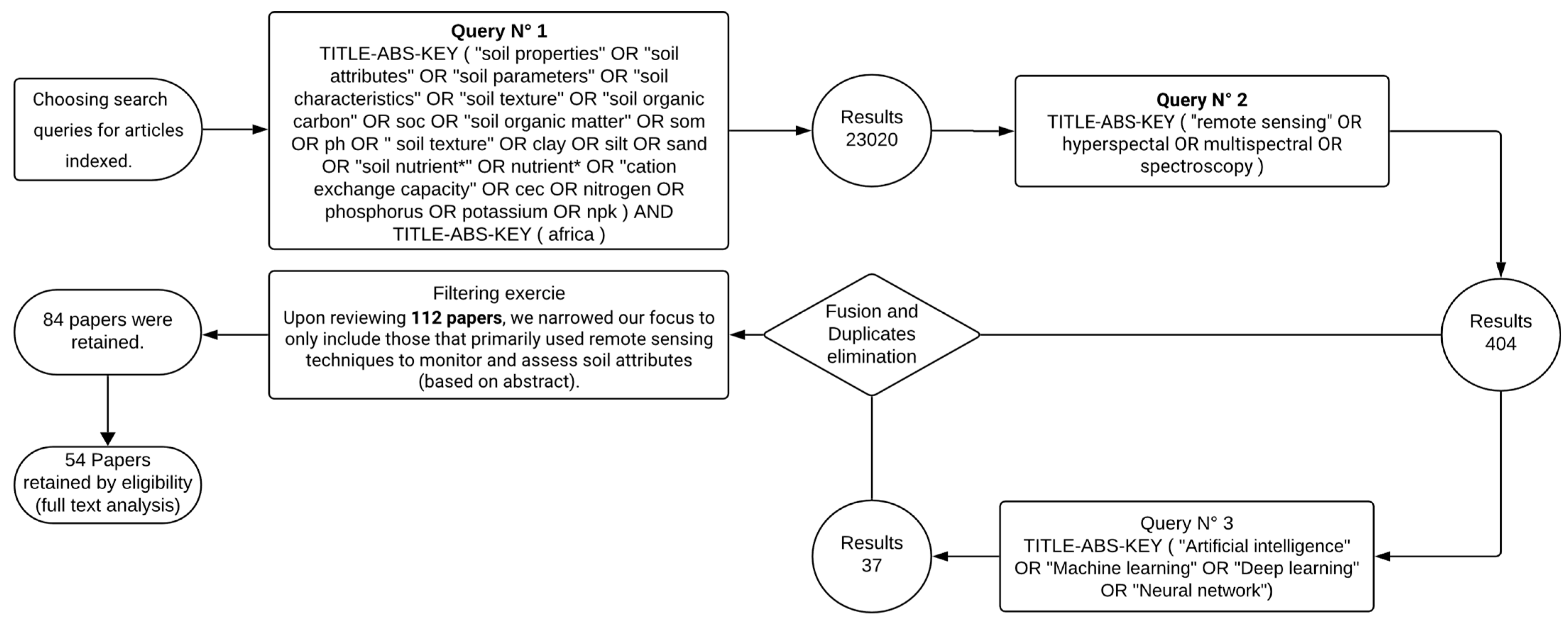
4. Methodology for Collection and Filtering of Papers

In our study, we explored the applications of various multi-approach techniques for estimating soil attributes, focusing on studies published between 2008 and 2024, since 2008 is the year when scientists can freely examine widely used remote sensing images (such as Landsat). We carried out a comprehensive literature search using several scientific databases, focusing primarily on Scopus. To ensure a targeted selection of publications dealing with soil attribute estimation, we established a series of criteria. These criteria are (a) the presence of keywords such as “soil attributes”, “remote sensing” and “Africa” in the title, abstract, or designated keywords of the publication, the word “Africa” being used to specifically target studies carried out on the African continent; (b) a complete match between the predefined keywords (mentioned in criterion (a)) and the corresponding keywords, title or abstract of the candidate literature; and (c) publication in English in a peer-reviewed scientific journal. In line with these guidelines, our search was based on the addition of keywords related to the main search terms mentioned in criterion (a). To this end, we used three mutually complementary queries in our database searches, each expanding on one of the main keywords with relevant synonyms and related terms. For “soil attributes”, we included terms such as “Nitrogen”, “Potassium”, “Soil Organic Carbon” (SOC), “pH” and others. For “Remote Sensing”, we expanded our query to include the terms “Hyperspectral”, “Multispectral” and “Spectroscopy”. While our review primarily focuses on hyperspectral data for soil attribute estimation, we included multispectral-related studies to highlight key advancements and comparisons in remote sensing applications. In addition to these two axes, we also established a third query focusing on AI, adding keywords such as “AI”, “Machine Learning”, “Deep Learning”, and “Neural Networks”. This approach ensured that we did not overlook studies incorporating advanced AI technologies in the analysis of remote sensing data and soil attributes. These customized queries enabled us to effectively narrow our search field while ensuring the inclusion of comprehensive and relevant literature.
The initial search yielded a total of 23,020 publications. This number was reduced to 404 publications by incorporating remote-sensing keywords in the second search. The results of a third search, which included terms associated with AI, were combined with those of the previous search, and then duplicates were removed. After a thorough review of the search scope, we carefully selected 54 publications that precisely met the objectives of our study. Figure 3 graphically illustrates the search we conducted in the Scopus database and the selection process.
In addition to the designated keywords, specific timeframe, and geographical areas, the selected studies had to focus explicitly on the quantification and mapping of soil attributes using remote sensing techniques. We discarded a large number of publications that, while related to remote sensing, did not directly address soil property estimation, or were otherwise outside the scope of this review. In terms of geographical scope, the search included studies from 15 African countries: Burkina Faso, Cameroon, Egypt, Kenya, Lesotho, Libya, Madagascar, Malawi, Mali, Morocco, Nigeria, Senegal, South Africa, Tanzania, and Tunisia (Figure 4). The result is a comprehensive flow chart summarizing the selected studies, which focused on different soil attributes.

5. Results, Discussion and Recommendations

Over the past two decades, research into soil mapping techniques has expanded considerably over the world, underlining the growing recognition of the essential role of accurate soil characterization in solving a variety of environmental problems. However, African landscapes, characterized by ecological fragility and challenges such as soil salinity, flooding, and sub-optimal agricultural productivity, underline the urgent need for detailed knowledge of soil properties and their spatial variability. This knowledge is essential for developing strategies to mitigate these challenges, improve agricultural production, and reduce the yield gap.
It is important to mention that the proliferation of digital soil mapping research in Africa is supported by the availability of advanced remote sensing technologies, including high-resolution satellite imagery and high spectral resolution spectroscopy, as well as the emergence of various AI models. These technological advances have catalyzed significant progress in soil management research, providing researchers and practitioners with effective tools for tackling complex soil-related issues. In this study, we have selected and analyzed 54 papers that highlight the critical role of remote sensing and AI as central techniques for estimating and analyzing soil properties. This rigorous filtering also reflects the limited number of soil-focused remote sensing studies available across the continent, which could highlight disparities in research capacity and data accessibility among African countries. Figure 5 shows the temporal trend in the number of papers devoted to estimating and mapping soil properties in African landscapes. As shown in Figure 5, a peak of 10 publications in both 2020 and 2022, with a general upward trajectory observed from 2013 to 2024.
The methodologies and results of these studies are detailed in Table 4, which summarizes the sensors and models used, the pre-processing methods applied, and the soil properties targeted. This overview highlights the diverse approaches employed in digital soil mapping research across Africa, offering valuable insight into progress and emerging trends in the field.
While Table 4 provides a valuable overview of the remote sensing approaches used for soil attribute estimation in Africa, it is important to note that studies explicitly linking soil attributes to yield gap analysis remain scarce or even non-existent. One key reason for this gap is the limited availability of high-resolution, remote sensing-derived digital soil maps, particularly fertility maps, which are essential for accurate modeling of soil-yield relationships [3]. This lack of spatially explicit soil data may explain the underrepresentation of soil properties in African yield gap analyses. However, selected empirical studies underscore the importance of incorporating soil data. For instance, in western Kenya, Munialo et al. [214] found that maize yield gaps of up to 54% were significantly influenced by soil-related factors, including available phosphorus (P), zinc (Zn), silt content, and the depth of compacted layers, based on on-farm surveys and multivariate analysis. Similarly, in Tanzania, Kwesiga et al. [215] applied the APSIM crop model integrated with remote sensing data, revealing that improved management (e.g., fertilizer use, bunding, leveling) could close 25–60% of the yield gap, with soil texture and nutrient status as key determinants.

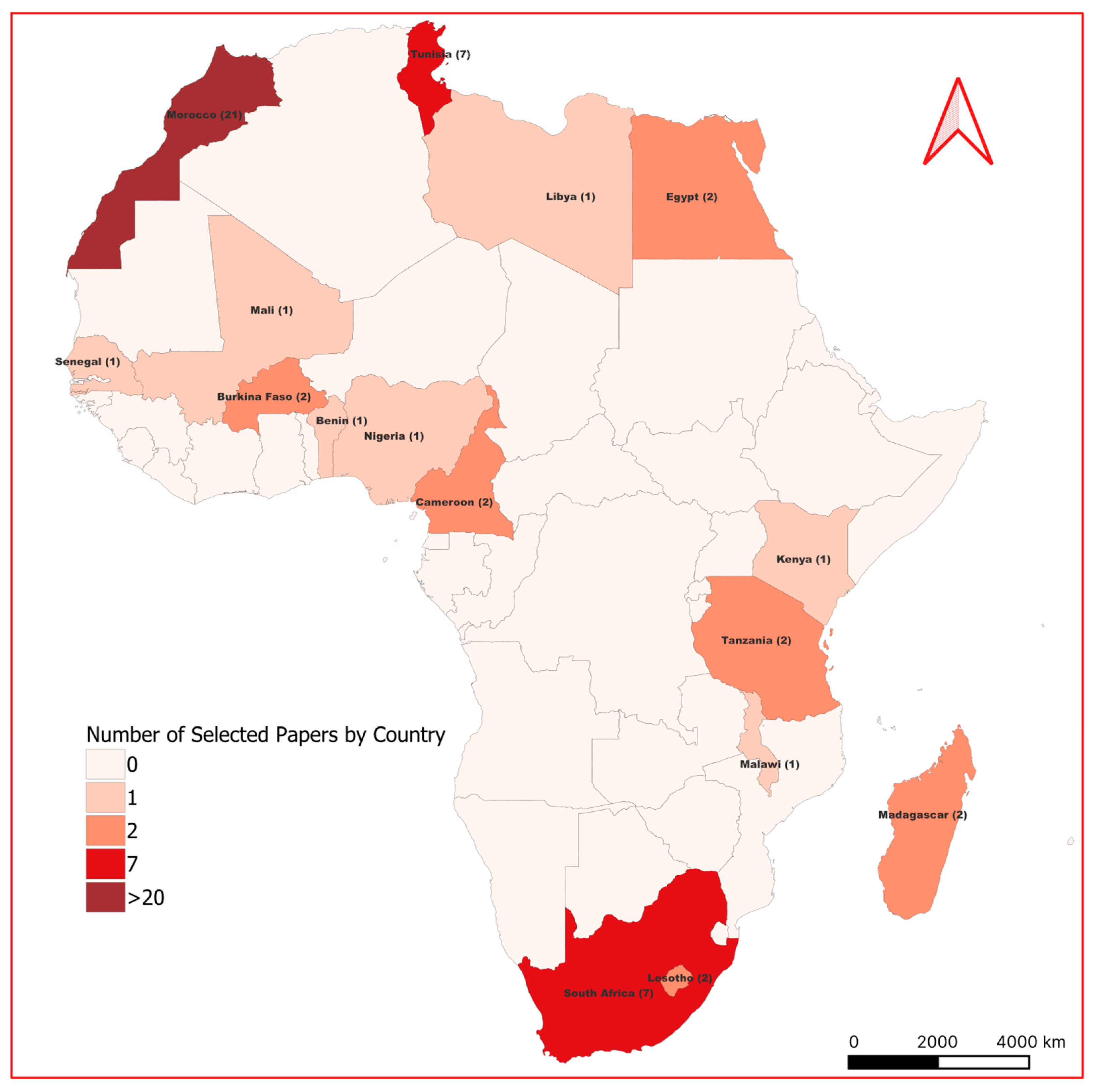
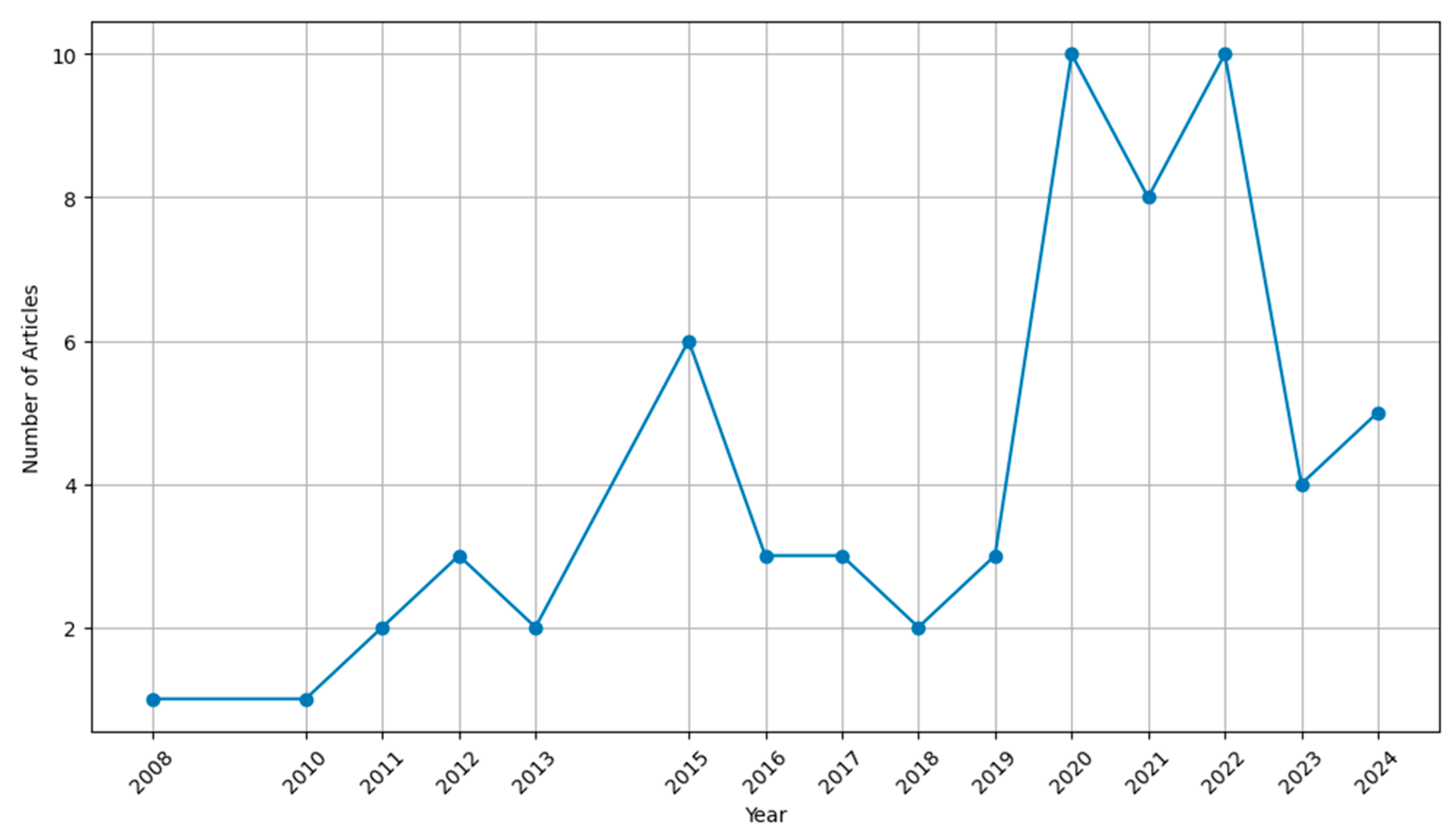
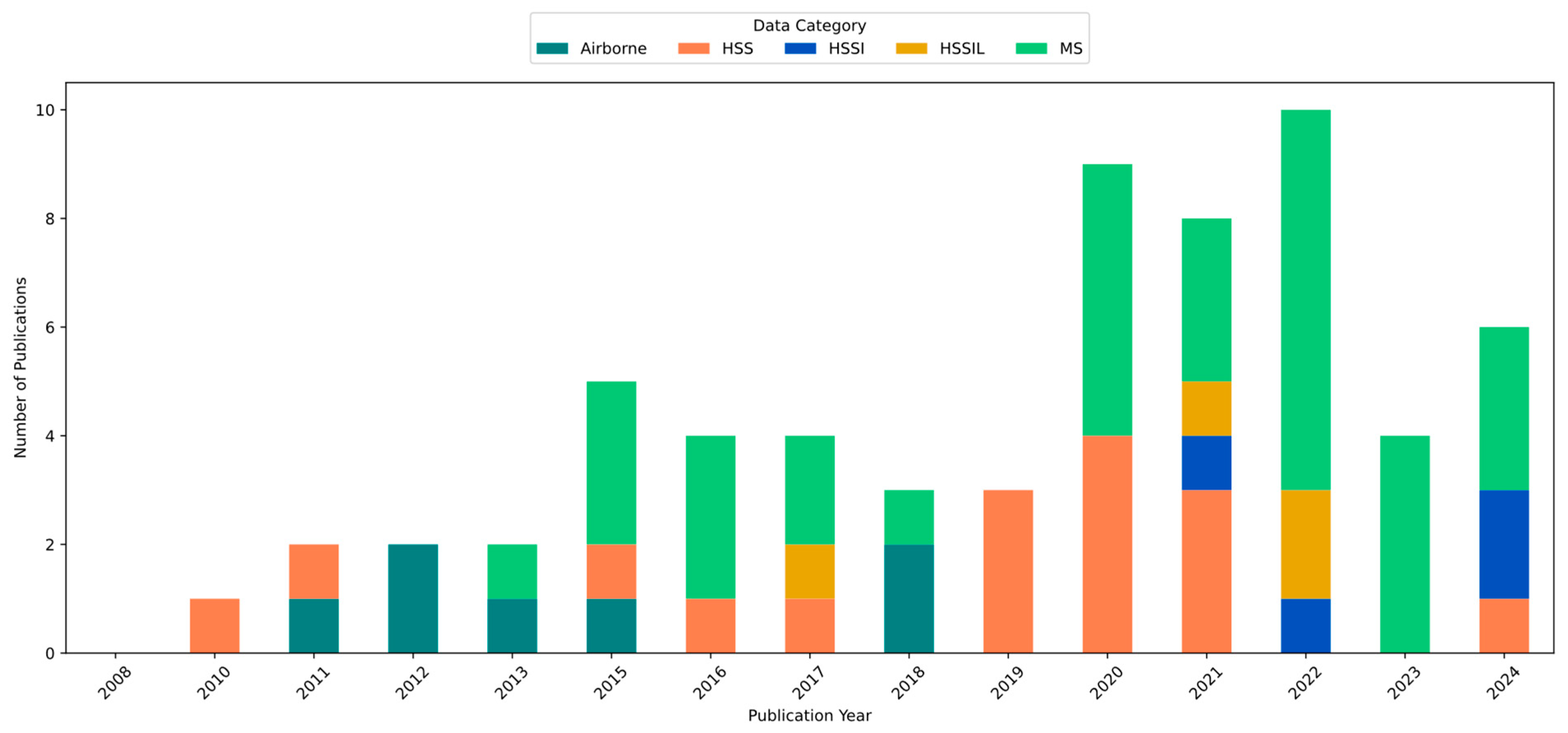
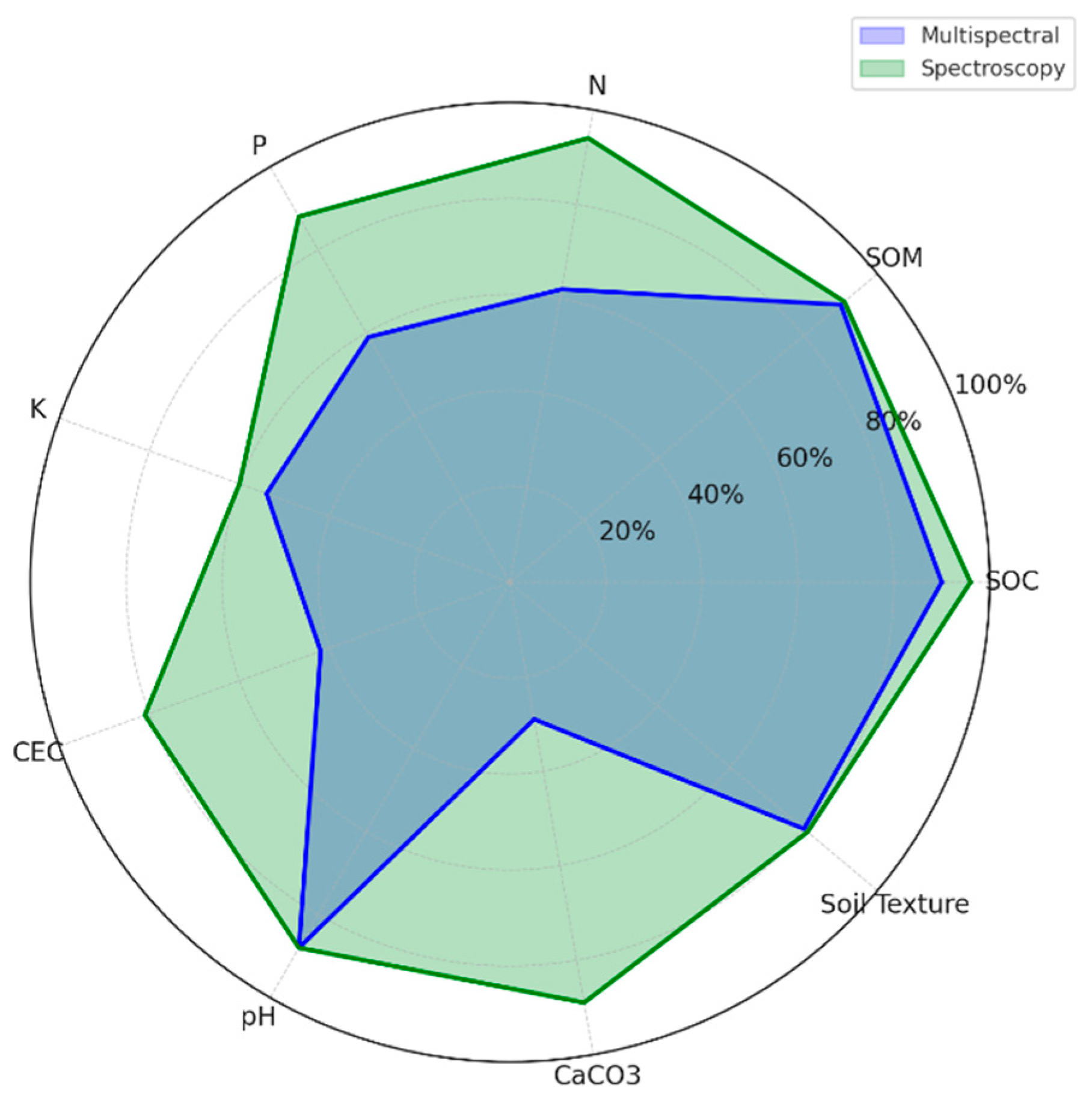
5.1. Remote Sensing Sensors Used for Soil Properties Estimation in Africa
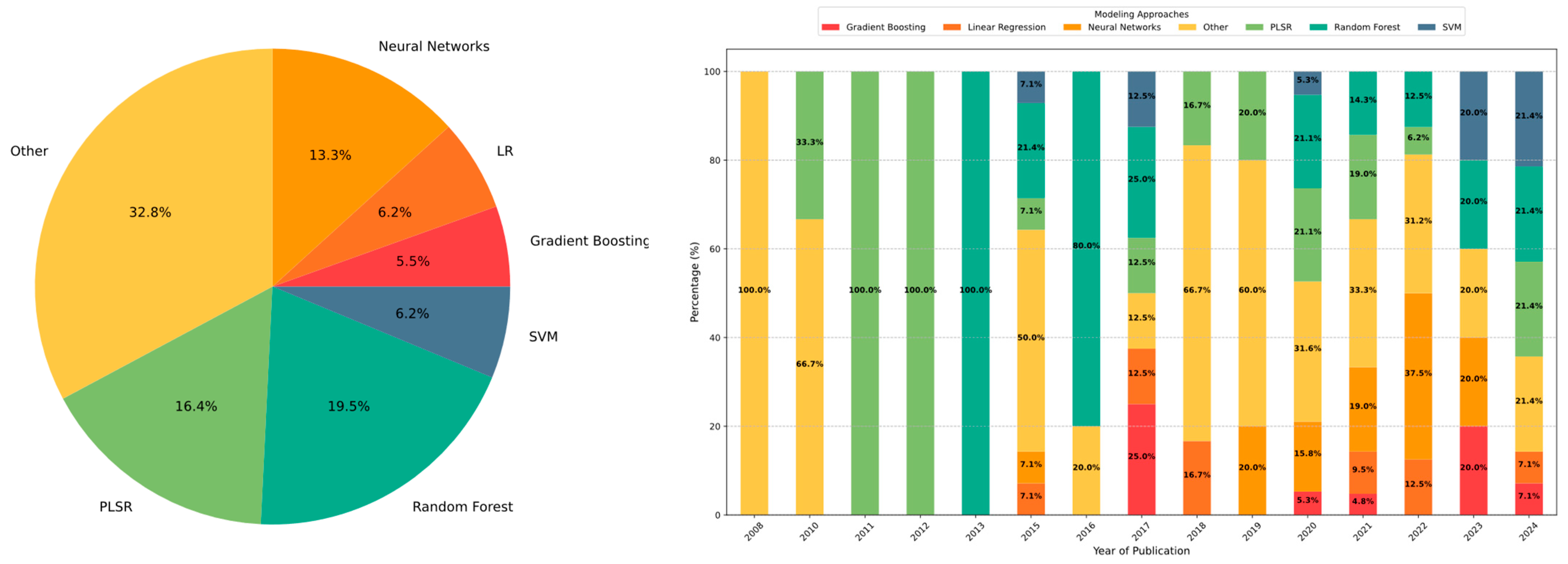
The selection of an appropriate remote sensing method is primarily influenced by application requirements, target properties, and the desired level of precision. These methods vary considerably in terms of their spatial, spectral, and temporal characteristics, as well as their platform configurations.
Figure 6 clearly illustrates the number of studies that have utilized multispectral versus hyperspectral data since 2008. Notably, the number of studies employing multispectral sensors overwhelmingly surpasses those using spectroscopy, airborne hyperspectral imaging, or satellite hyperspectral imaging for estimating soil properties. This frequent use of multispectral data can be largely attributed to the early and widespread availability of various multispectral platforms (i.e., Landsat), their extensive spatial coverage, and their relatively high revisit frequency. Conversely, the adoption of proximal spectroscopy has been driven by its significant advantages, including high spectral resolution, which enables the detection of sensitive spectral bands associated with different soil properties. Additionally, spectroscopy is particularly advantageous as it mitigates meteorological constraints, given that it can be employed under controlled conditions.
Despite its demonstrated superior performance for soil property estimation [216], the adoption of airborne hyperspectral imagery remains notably limited, primarily due to accessibility challenges. For instance, all studies using sensors mounted on airborne platforms (e.g., AISA Dual) in Tunisia were exclusively conducted by the same research team [14,85,175,176,177]. A similar situation is observed in South Africa, where the two studies utilizing airborne hyperspectral imaging (i.e., HyMap) were performed by the same author [192,196].
Although global advancements in spaceborne hyperspectral technologies—such as PRISMA, EnMAP, and DESIS—have significantly improved data availability, their adoption in Africa has been relatively recent, likely due to the complexity of data analysis and the substantial computational resources required. For instance, [27] effectively demonstrated the capability of PRISMA hyperspectral imagery for soil fertility mapping in Morocco, specifically assessing phosphorus and potassium content in cultivated areas. Similarly, ref. [26] successfully applied advanced band selection techniques to quantify total nitrogen levels in Moroccan agricultural soils. In another study, ref. [28] utilized PRISMA hyperspectral imagery combined with wrapper-based Recursive Feature Elimination (RFE) and ensemble machine learning models to accurately predict SOM) P2O5, and K2O in Morocco.
The preference for multispectral and spectroscopic methods over hyperspectral imaging in most published studies likely stems from accessibility and cost considerations. Nevertheless, existing research highlights the promising potential of hyperspectral imaging for enhancing agricultural practices in Africa. This observation aligns with other reviews [3,9] which have similarly noted a growing trend in the use of hyperspectral sensors. Furthermore, the increasing availability of advanced hyperspectral platforms, along with forthcoming missions like PRISMA-2GEN, HISUI, and CHIME—is expected to further accelerate the adoption of remote sensing applications in African agriculture. These sophisticated sensors can provide invaluable data for soil condition assessment and soil property estimation, either directly or as auxiliary inputs, thereby fostering sustainable agricultural practices.
In the African context, meteorological factors such as persistent cloud cover, particularly in tropical regions, often hinder the effective use of optical satellite imagery [99]. These structural and environmental constraints necessitate more adaptable platforms, such as UAVs mounted hyperspectral systems, which can operate under clouded conditions and capture field-scale heterogeneity with greater precision.
Recently, the emergence of UAV-based systems in various precision agriculture applications has demonstrated remarkable reliability [37]. Although their adoption for soil property estimation in Africa has remained relatively limited, it is expected to increase in the coming years. These platforms are particularly well-suited for small-scale applications, as they offer the flexibility to tailor flight schedules, provide exceptionally high spatial resolution, and effectively capture the heterogeneity of agricultural surfaces at the field scale [217].

5.2. AI Models

The choice of an appropriate calibration technique remains a fundamental challenge in soil property estimation, as its effectiveness depends on multiple factors. Primarily, the quality and preparation of input data play a crucial role in shaping model performance. The model’s ability to extract relevant information and establish correlations within the dataset is equally important. This ability, however, varies depending on the complexity of the algorithm and the type of data being processed, which can range from a few spectral bands (i.e., multispectral data) to a high-dimensional dataset (i.e., hyperspectral data). Additionally, the nature of the dataset, whether it contains both spatial and spectral information or only spectral details (i.e., the case of spectroscopy), directly influences predictive performance. Complicating matters further, various sources of noise (e.g., sensor noise) present in the data may interfere with model accuracy, potentially preventing the algorithm from capturing key soil attributes effectively.
Over the past decade, machine learning and AI techniques have gained significant traction in soil attribute estimation across Africa. As illustrated in Figure 7 (left), the most widely used AI models for soil property mapping include Random Forest (19.5%) and Partial Least Squares Regression (PLSR, 16.4%), which stand out as dominant approaches. These are followed by Neural Networks (13.3%), while (SVM, 6.2%), linear regression models (6.2%, including simple linear regression, multiple linear regression, and stepwise linear regression), and Gradient Boosting (5.5%) also demonstrate substantial use in recent studies.
The evolution of these techniques over time reflects the increasing reliance on AI-driven methodologies. As shown in Figure 8 (right), before 2013, soil property estimation was predominantly based on simpler statistical models, with PLSR and linear regression being the most employed approaches. However, after 2014, the rapid advancements in AI led to a noticeable shift toward machine learning models, which often demonstrated superior performance over conventional multivariate statistical methods. For instance, RF has consistently outperformed PLSR in predicting SOC, largely due to its robustness in handling high-dimensional datasets and non-linear relationships [191].
From 2015 onward, the increasing computational power and availability of diverse benchmark datasets facilitated the adoption of deep learning-based models in Africa. These models have demonstrated remarkable predictive capabilities, especially in soil spectroscopy applications. For instance, the 1D-CNN model achieved high predictive accuracy, with an R2 = 0.878 and a performance ratio of 2.492, indicating precise estimation capabilities. Compared to PLSR, both RF and 1D-CNN improved root mean squared error (RMSE) values by 4.37% and 23.77%, respectively. Additionally, in laboratory spectroscopy-based studies, Artificial Neural Networks (ANNs) have outperformed traditional methods such as Decision Trees (DTs) and K-Nearest Neighbors (k-NNs) in predicting SOM [183]. Similarly, in a separate study, Backpropagation Neural Networks (BPNNs) demonstrated superior accuracy in estimating total phosphorus (TP) compared to other machine learning techniques [181]. These advancements underscore the increasing reliability of AI-driven soil mapping techniques and their capacity to enhance predictive performance. However, despite these methodological improvements, significant challenges remain, particularly when using multispectral satellite imagery for soil property estimation. Studies have shown that AI models still struggle to achieve high accuracy when estimating macronutrients such as NPK, and CEC (Figure 8) [212]. The limited spectral resolution of multispectral sensors restricts their ability to capture subtle variations in soil properties, leading to low-to-moderate prediction accuracy.
Given these limitations, hyperspectral satellite imagery is increasingly being recognized as a more promising alternative in the African research community, offering enhanced spectral richness for large-scale soil assessments. Recent research in Africa has highlighted the superior predictive capabilities of hyperspectral datasets on key fertility properties (i.e., SOM, P, K) [202] compared to multispectral approaches. These findings emphasize the importance of careful model selection and preprocessing techniques (e.g., Features Selection/Engineering) to fully exploit the potential of hyperspectral imaging for soil mapping. However, despite its advantages, the effective application of hyperspectral AI models continues to be hindered by challenges related to data availability, computational complexity, and model scalability.
A major limitation faced by the remote sensing and AI research communities is the scarcity of high-quality ground reference data, which is essential for training and validating predictive models. Additionally, scale effects remain a persistent challenge—models trained on small-scale datasets often struggle to generalize across diverse landscapes due to the spatial variability of soil properties [167]. To mitigate these challenges, self-supervised learning (SSL) and hybrid AI models have emerged as innovative solutions. Recent studies, such as SSL-SoilNet [29] have demonstrated the effectiveness of self-supervised learning in leveraging large volumes of unlabeled data, enabling models to pre-train on diverse datasets before fine-tuning with limited labeled samples. This approach significantly reduces the dependency on ground-truth soil samples, thereby improving model generalization and robustness across different soil types. Furthermore, integrating multi-source datasets, such as satellite imagery, topographic indices, and climate series, can enhance soil property predictions [218].
Indeed, machine learning methods, ranging from traditional algorithms (e.g., RF, SVM) to more advanced deep learning architectures (e.g., CNNs, RNNs/LSTMs, transformers, and foundation models) have demonstrated moderate to strong predictive accuracies for estimating soil attributes. However, a significant limitation of many studies in this field lies in their lack of interpretability. These approaches are often treated as “black boxes”, with limited insight into the mechanisms driving model outputs [219]. Another critical drawback of applying such models indiscriminately is their tendency to ignore the spatial variability and spatial dependence inherent to soil systems, specifically, the interactions of soil properties with environmental factors such as climate, topography, and land use [220]. This spatial structure is essential not only for improving predictive accuracy but also for fostering a deeper, process-based understanding of soil systems [221]. In contrast, classical geostatistical approaches like Geographically Weighted Regression (GWR) provide improved interpretability by explicitly accounting for spatial non-stationarity and local geographic relationships, thereby enabling more meaningful spatial process analysis. For instance, Song et al. [222] proposed a Wavelet Geographically Weighted Regression (WGWR) framework that integrates multiscale spectral decomposition with localized regression. Their model substantially enhanced soil property mapping from vis–NIR spectra, achieving up to a 50.9% gain in R2 over classical methods such as Partial Least Squares Regression (PLSR), while offering spatial insights by incorporating geographic variability alongside spectral features. Similarly, Zeng et al. [223] applied a Mixed Geographically Weighted Regression (MGWR) model to identify both spatially fixed and spatially varying environmental influences on soil organic matter (SOM). Conducted across two contrasting regions in China, MGWR outperformed both GWR and Multiple Linear Regression (MLR), reducing RMSE by up to 12.8% and yielding interpretable spatial maps that highlighted localized effects of factors such as elevation, precipitation, and lithology. These findings demonstrate MGWR’s ability to balance predictive accuracy with explanatory power, particularly in environmentally complex landscapes. Despite its potential, GWR and its variants remain underutilized in soil mapping, and when applied, are often limited to studies focused primarily on soil organic carbon (SOC) [220]. Moreover, GWR requires dense spatial data and is computationally intensive, which can restrict its scalability for large or heterogeneous areas [224]. Spectroscopic modeling of soil properties also frequently overlooks spatial dependencies, despite the use of hyperspectral imagery for improved soil estimation [222]. Classical ML models typically fail to capture spatial and neighborhood context, and even advanced models like CNNs or ensemble methods struggle to fully represent geographical relationships. To address these challenges, new learning paradigms have emerged—most notably the approach introduced by Kakhani et al. [29]. Their method focuses on learning geographical linkages between multimodal data (e.g., climate variables and remote sensing imagery) using transformer-based architectures. It captures spatiotemporal dependencies through contrastive self-supervised learning across both image-based and time-series inputs, enabling more robust and context-aware predictions of soil properties. Despite the growing sophistication of machine learning (ML) and deep learning (DL) models in environmental sciences, including soil organic carbon (SOC) prediction, the integration of explainable artificial intelligence (XAI) remains limited and fragmented in the literature. Most current studies prioritize predictive accuracy over interpretability, often failing to explore why a model makes a certain prediction or which environmental drivers contribute most meaningfully to spatial patterns. This interpretability gap hinders scientific discovery and undermines the credibility of AI-assisted environmental modeling, particularly for policy and management decisions that require transparency. As highlighted by Kakhani et al. [225], while post hoc techniques like SHAP or permutation importance are becoming more popular, they often suffer from computational inefficiency, limited spatial contextualization, or inconsistencies across model types. More importantly, Kakhani et al. introduced a novel learning-based explanation model that treats interpretability itself as a supervised learning task—allowing flexible, model-agnostic, and spatially explicit attribution of input features. Yet, such advanced explanation frameworks are still rarely applied in soil science, and systematic comparative studies across model classes remain scarce.

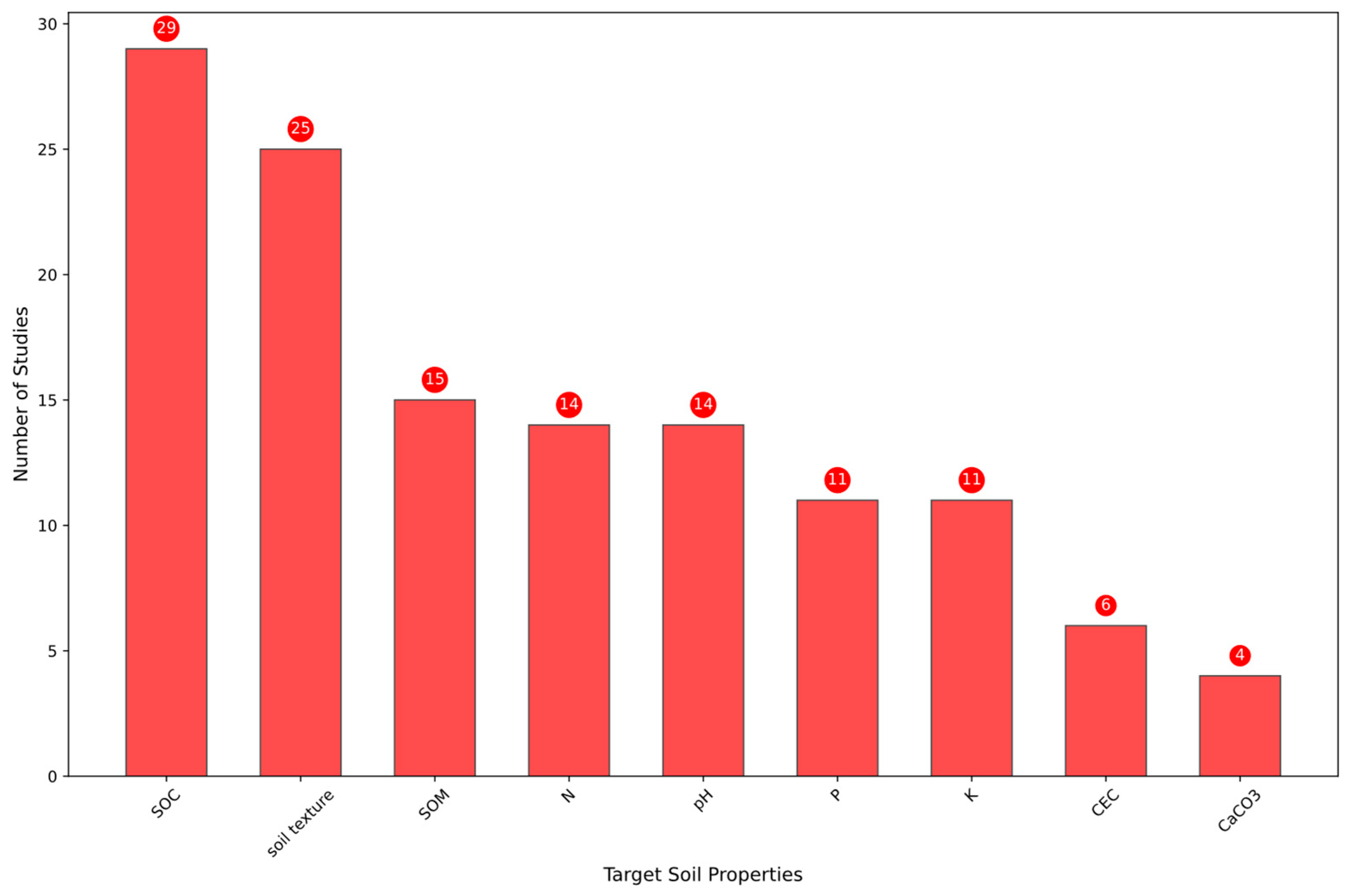
5.3. Most Predicted Soil Properties

Another aspect of this review is assessing progress in the estimation and mapping of key agricultural soil properties using remote sensing techniques. These properties—SOC, NPK, SOM, and soil texture (clay, sand, and silt fractions), among others—play fundamental roles in soil fertility, crop growth, and overall agricultural productivity [226].
Among the studies reviewed, more than half (51%) focused on predicting multiple soil attributes, highlighting the interconnected nature of soil properties and their combined influence on plant growth. Notably, SOC-related properties (e.g., SOC content, density, and stock) were the most frequently predicted (Figure 9). This widespread focus can be attributed to SOC’s pivotal role in enhancing soil structure, improving water retention, and increasing nutrient availability. More specifically, SOC significantly influences CEC, which regulates the retention and exchange of essential nutrients, including NPK. Given the strong correlation between SOC and soil fertility, its accurate estimation remains a priority for soil management and agricultural planning [227].
The second most studied property was soil texture, which is a crucial determinant of water-holding capacity, aeration, and nutrient retention. Its impact on plant growth is substantial, as clay-rich soils tend to retain water efficiently but may impede drainage, whereas sandy soils promote rapid water infiltration yet suffer from poor moisture retention. Furthermore, excessive soil compaction can restrict root growth, limiting the uptake of nutrients and ultimately reducing crop performance [228].
While significant progress has been made in predicting SOC and soil texture, predicting nutrient-related properties, such as NPK, and CEC, remains significantly more challenging. In particular, nitrogen lacks a direct spectral signature, making its remote sensing-based estimation heavily reliant on indirect proxies such as SOC content, soil texture, or vegetation indices [13]. Similarly, phosphorus and potassium estimation is complicated by their interactions with soil minerals and organic matter, which influence their availability and spectral reflectance behavior [229].
Beyond chemical and physical soil attributes, biological activity within the soil plays a crucial role in nutrient cycling and overall soil health, yet it remains largely inaccessible to remote sensing methods. Beneficial microorganisms, such as mycorrhizal fungi and nitrogen-fixing bacteria, are essential for organic matter decomposition, nutrient mineralization, and soil structure formation. Additionally, these microbial communities can suppress soil-borne pathogens, contributing to improved plant resilience and productivity [230].
The spatial and temporal variability of soil properties presents a significant challenge for achieving optimal agricultural productivity. Variations in soil texture, nutrient availability, and moisture retention, compounded by climatic factors such as rainfall distribution and temperature fluctuations, lead to considerable heterogeneity in crop performance [231]. Consequently, identifying and managing within-field variability remains a key focus in modern agriculture.
Overall, the interplay of physical, chemical, and biological soil properties determines crop yield potential and the magnitude of the yield gap. Emerging technologies such as hyperspectral remote sensing and AI provide new avenues for assessing and managing physico–chemical properties, thereby improving our ability to close yield gaps and achieve sustainable agricultural production.

5.4. Advances in Soil Mapping in Africa Through the Integration of Hyperspectral Remote Sensing and AI

To date, the integration of hyperspectral remote sensing and AI for soil property mapping in Africa remains at an early stage, with only a limited number of practical, field-based implementations. Among the available studies, satellite-based platforms—particularly PRISMA—have shown growing potential. In Morocco, Misbah et al. [28] combined SVR, GPR, and PLSR models with Recursive Feature Elimination (RFE) to predict SOM, P2O5, and K2O, achieving R2 = 0.65 for SOM. This ensemble approach improved performance (i.e., from R2 = 0.27), but the continued reliance on traditional regression models limits adaptability in more heterogeneous or non-linear field environments. Similarly, Gasmi et al. [27] applied Random Forest (RF) to PRISMA data, achieving R2 = 0.69 and RPIQ = 2.56 for SOM, though lower accuracy for phosphorus and potassium suggests limitations in RF’s spectral discrimination and generalization ability. In a separate study, Misbah et al. [26] demonstrated R2 = 0.84 and RMSE = 0.08 g/kg for total nitrogen using selected SWIR bands, confirming PRISMA’s spectral utility. However, the persistent absence of advanced AI methods—particularly deep learning and transformer-based architectures—highlights a critical gap, as these techniques are specifically designed to extract complex, non-linear patterns from high-dimensional spectral data, which are essential for robust and scalable soil property mapping in heterogeneous African landscapes.
In contrast, airborne hyperspectral systems, though capable of capturing high-resolution data, remain far less accessible in Africa due to logistical and financial constraints. Moreover, the limited number of airborne studies conducted to date tend to focus on a narrow range of soil properties, restricting the possibility of conducting broad, sensor-to-sensor comparisons. Among the few examples, Gomez et al. [85] applied PLSR to AISA-DUAL imagery in Tunisia, achieving R2 > 0.71 and RPIQ > 3 for clay content, though the linear nature of PLSR limits its capacity to model complex spatial–spectral relationships. Bayer et al. [196] used MLR and spectral unmixing with HyMap data in South Africa to estimate SOC (R2 = 0.62, RPD = 1.57), demonstrating the utility of airborne sensing under vegetation cover. However, the absence of advanced task-specialized models, such as those derived from foundational architectures (e.g., Hyperisgma) represents a missed opportunity, as these models are better equipped to handle vegetation interference and extract discriminative features for improved prediction.
Beyond airborne and satellite data, proximal spectroscopy continues to provide the highest predictive accuracy under controlled conditions, In the Triffa Plain, Lazaar et al. [187] achieved R2 = 0.93 and RMSE = 0.13 for SOM using a pistol grip spectrometer and classical regression. Reda et al. [186] applied Extreme Learning Machines (ELMs) on NIR spectra and reported R2 = 0.96 and RPD = 4.87, substantially outperforming RF and PLSR. These results support ELM’s efficiency and generalizability in clean datasets. Yet, while proximal spectroscopy excels in laboratory contexts, it remains impractical for broad-scale mapping due to its point-based nature, lack of automation, and sensitivity to measurement setup variability.
This performance (i.e., hierarchy—proximal > airborne > satellite) reflects a fundamental trade-off between accuracy and scalability. A central challenge in current research is how to translate the high accuracy achieved in laboratory-based spectroscopy to broader spatial scales without compromising model robustness. Successfully addressing this would represent a major step toward the development of operational models that can deliver scalable, reliable insights to support informed decision-making across diverse agricultural stakeholders.
Beyond algorithmic constraints, institutional and infrastructural barriers further limit progress. These include insufficient training datasets, the lack of standardized soil spectral libraries, and restricted access to geospatial computing infrastructure. For instance, Fertimap—one of the most prominent soil fertility mapping initiatives in Africa—successfully mapped national soil properties in Morocco using over 33,000 field samples [232], but relied on traditional geostatistical methods (e.g., Kriging) rather than leveraging AI or hyperspectral analytics. Similarly, the iSDA soil initiative has made significant strides by producing high-resolution soil maps across sub-Saharan Africa using legacy data and machine learning [233]. However, its models are not yet integrated with hyperspectral inputs, illustrating a broader disconnect between the richness of available data and the application of advanced spectral-AI methods in African soil monitoring systems. Moreover, even when cutting-edge models such as transformers or foundational architectures are trained successfully, deploying them in real-world, resource-constrained environments introduces additional challenges. Their computational complexity and large parameter sizes often require high memory capacity and processing power, which can hinder inference speed and limit practical implementation in low-configuration settings—conditions that are common in many African contexts [152].

5.5. Challenges and Recommendations

Hyperspectral data have demonstrated high accuracy in proximal spectroscopy, paving the way for hyperspectral remote sensing as a viable alternative to traditional laboratory methods for soil property estimation. These advancements offer a transformative opportunity for large-scale soil mapping, enabling the characterization of key soil attributes with greater spectral precision. However, despite these promising capabilities, several challenges persist, particularly in relation to spatial and temporal resolution, preprocessing complexity, limited availability of high-quality ground reference data, and the optimization of AI models for soil spectral identification and mapping.
Another major challenge lies in the methodological rigor of model validation. Many studies apply AI to hyperspectral soil mapping without taking into account spatial dependencies in the data. Conventional random cross-validation often inflates performance measures due to spatial autocorrelation, close samples are statistically similar, leading to over-optimistic accuracy estimates. Moran’s I and other spatial statistics have shown that spatial autocorrelation can distort model results when not properly accounted for [234]. Instead, spatial cross-validation techniques (e.g., leave-location-out, spatial k-fold) are recommended to ensure realistic accuracy estimates that reflect true field performance [235,236]. Another problem is preferential field verification, where samples are collected in accessible or visually homogeneous areas (e.g., near roads or uniform fields). This introduces a sampling bias, limiting the applicability of the model to under-represented soil types or landscapes. Spatially balanced models, such as conditioned Latin hypercube sampling or stratified random sampling, provide representative coverage of environmental gradients [188]. The uncertainty of soil forecasts is another key issue that is often overlooked. It refers to the degree of confidence we have in the model’s predictions at each location. Instead of treating all predictions as equally reliable, models should estimate and map areas of low confidence. As Stumpf et al. [237] have shown, these uncertainty maps, generated by measuring the variation in model results, can highlight areas where models are less confident, and guide the collection of additional data accordingly. This approach improves model accuracy and ensures smarter, more targeted sampling where it matters most.
A detailed summary of these technological bottlenecks and targeted recommendations to address them is presented in Table 5, highlighting key pathways for advancing hyperspectral-AI integration for yield gap analysis. Addressing these challenges is crucial to fully unlocking the potential of hyperspectral remote sensing for precision agriculture and sustainable soil management.

6. Conclusions

This extensive review has explored the advancements in hyperspectral remote sensing and AI for estimating and mapping soil properties, focusing on their application in African landscapes. These technologies provide scalable, cost-effective, and high-resolution solutions to monitor critical soil parameters, optimize actual crop yields, and reduce the yield gap. However, their adoption across Africa remains limited, highlighting the need for targeted efforts to harness their potential. A key contribution of this review is the emphasis on the importance of selecting appropriate advanced AI models to enhance soil property analysis. Commonly used techniques, such as Partial Least Squares Regression (PLSR), RF, and Support Vector Machines (SVMs), have demonstrated strong capabilities in soil attribute estimation.
Furthermore, emerging approaches like transformers show great promise in capturing complex spatial and spectral dependencies, enabling more accurate predictions in hyperspectral data analysis. Meanwhile, foundational models stand out for their ability to extract pure soil signals through advanced tasks like spectral unmixing, making them particularly valuable for improving soil mapping accuracy. These models, often trained using self-supervised learning (SSL), learn from large volumes of unlabeled data and be fine-tuned for soil prediction tasks in new regions, even with limited training samples. Their success in tasks such as classification and segmentation also demonstrates their adaptability and performance potential in soil science. In addition to foundational models, the SSL technique, including contrastive learning, can be applied separately to less complex architectures, such as transformers or convolutional networks, helping to improve model generalization while reducing ground truth data requirements. These approaches offer practical pathways to scaling soil mapping in data-scarce environments like Africa.
Despite their potential, these advanced methodologies remain underutilized in Africa, underscoring a significant technological gap. The findings of this review emphasize the critical need to strengthen local research capacities, enhance computational infrastructure, and foster interdisciplinary collaborations to support the adoption of these advanced tools. Investments in training, accessible hyperspectral technologies, and context-specific solutions are essential to overcome current challenges. Moreover, integrating hyperspectral data with complementary sources, such as radar and thermal infrared, can provide more holistic insights into subsurface soil conditions, moisture dynamics, and physical characteristics like surface roughness, which influence reflectance behavior and affect prediction accuracy. Equally important is the development of strategic ground-truth soil sampling networks, which remain essential for calibrating models and ensuring generalizability across diverse African landscapes. Furthermore, Improving interpretability in AI-based soil analysis is also critical. As models grow in complexity, future research should prioritize the development of explainable AI (XAI) tools that highlight relevant spectral bands, spatial relationships, and uncertainty sources which makes predictions more transparent and actionable.
Additionally, implementing policy frameworks that encourage sustainable soil management and innovation will further facilitate the integration of these technologies. Future research should prioritize advancing AI-driven approaches, reducing the costs of hyperspectral sensors, and fostering inclusive innovations tailored to African agricultural systems. By addressing these challenges, hyperspectral remote sensing and AI can unlock transformative opportunities for precision agriculture. Such efforts will not only close the yield gap and optimize resource use but also enhance the resilience of African agriculture to climate variability and environmental constraints, ultimately contributing to food security and sustainable development across the continent.

Author Contributions

All the authors have contributed substantially to this manuscript. Conceptualization, A.L., F.B. and A.C.; methodology, N.E.B., H.H. and M.B.; validation, N.E.B., H.H., A.L., A.E.-B., F.B. and M.B.; formal analysis, N.E.B. and H.H.; investigation, N.E.B. and M.B., writing—original draft preparation, N.E.B.; writing—review and editing, N.E.B., H.H., A.L., H.A.A. and A.E.-B.; supervision, A.L. and F.B.; co-supervision, H.H., A.E.-B., H.A.A. and A.C.; project administration, A.A., A.L. and A.C.; funding acquisition, A.C., A.L. and F.B.; All authors have read and agreed to the published version of the manuscript.

Funding

This project was financially supported by The Yield Gap project (agreement between OCP Foundation and UM6P). The lead author received financial support from UM6P through the Yield Gap Project.

Data Availability Statement

No data were used for the research described in the article.

Acknowledgments

The authors acknowledge the valuable technical support of all those who contributed to the conduct of this study. We also thank UM6P for providing AI-based resources that helped enhance the writing style. Additionally, we extend our gratitude to the academic editor and the anonymous reviewers for their time and effort in reviewing the earlier version of the manuscript.

Conflicts of Interest

The authors declare no conflicts of interest.

References

  1. La Situation Mondiale de l’Alimentation et de l’Agriculture 2023; FAO: Rome, Italy, 2023; ISBN 978-92-5-138418-3.
  2. Gono, O.P. Sustainable Land Management and Smallholder Farmers in Zimbabwe. Ph.D. Thesis, Walden University, Minneapolis, MN, USA, 1999. [Google Scholar]
  3. Khechba, K.; Laamrani, A.; Dhiba, D.; Misbah, K.; Chehbouni, A. Monitoring and Analyzing Yield Gap in Africa through Soil Attribute Best Management Using Remote Sensing Approaches: A Review. Remote Sens. 2021, 13, 4602. [Google Scholar] [CrossRef]
  4. Van Ittersum, M.K.; Cassman, K.G.; Grassini, P.; Wolf, J.; Tittonell, P.; Hochman, Z. Yield Gap Analysis with Local to Global Relevance—A Review. Field Crops Res. 2013, 143, 4–17. [Google Scholar] [CrossRef]
  5. Vanlauwe, B.; Amede, T.; Bationo, A.; Bindraban, P.; Breman, H.; Couedel, A.; Chivenge, P.; Corbeels, M.; Dobermann, A.; Fatunbi, W.; et al. Fertilizer and Soil Health in Africa: The Role of Fertilizer in Building Soil Health to Sustain Farming and Address Climate Change; International Fertilizer Development Center: Muscle Shoals, AL, USA, 2023. [Google Scholar]
  6. Silveira, M.L.; Kohmann, M.M. Maintaining Soil Fertility and Health for Sustainable Pastures. In Management Strategies for Sustainable Cattle Production in Southern Pastures; Elsevier: Amsterdam, The Netherlands, 2020; pp. 35–58. ISBN 978-0-12-814474-9. [Google Scholar]
  7. Barra, I.; Haefele, S.M.; Sakrabani, R.; Kebede, F. Soil Spectroscopy with the Use of Chemometrics, Machine Learning and Pre-Processing Techniques in Soil Diagnosis: Recent Advances—A Review. TrAC Trends Anal. Chem. 2021, 135, 116166. [Google Scholar] [CrossRef]
  8. Dworak, V.; Mahns, B.; Selbeck, J.; Gebbers, R.; Weltzien, C. Hyperspectral Imaging Tera Hertz System for Soil Analysis: Initial Results. Sensors 2020, 20, 5660. [Google Scholar] [CrossRef]
  9. Misbah, K.; Laamrani, A.; Khechba, K.; Dhiba, D.; Chehbouni, A. Multi-Sensors Remote Sensing Applications for Assessing, Monitoring, and Mapping NPK Content in Soil and Crops in African Agricultural Land. Remote Sens. 2021, 14, 81. [Google Scholar] [CrossRef]
  10. Abdulraheem, M.I.; Zhang, W.; Li, S.; Moshayedi, A.J.; Farooque, A.A.; Hu, J. Advancement of Remote Sensing for Soil Measurements and Applications: A Comprehensive Review. Sustainability 2023, 15, 15444. [Google Scholar] [CrossRef]
  11. Zhang, W.; Zhu, L.; Zhuang, Q.; Chen, D.; Sun, T. Mapping Cropland Soil Nutrients Contents Based on Multi-Spectral Remote Sensing and Machine Learning. Agriculture 2023, 13, 1592. [Google Scholar] [CrossRef]
  12. Wang, X.; Han, J.; Wang, X.; Yao, H.; Zhang, L. Estimating Soil Organic Matter Content Using Sentinel-2 Imagery by Machine Learning in Shanghai. IEEE Access 2021, 9, 78215–78225. [Google Scholar] [CrossRef]
  13. Mulder, V.L.; De Bruin, S.; Schaepman, M.E.; Mayr, T.R. The Use of Remote Sensing in Soil and Terrain Mapping—A Review. Geoderma 2011, 162, 1–19. [Google Scholar] [CrossRef]
  14. Lagacherie, P.; Sneep, A.-R.; Gomez, C.; Bacha, S.; Coulouma, G.; Hamrouni, M.H.; Mekki, I. Combining Vis–NIR Hyperspectral Imagery and Legacy Measured Soil Profiles to Map Subsurface Soil Properties in a Mediterranean Area (Cap-Bon, Tunisia). Geoderma 2013, 209–210, 168–176. [Google Scholar] [CrossRef]
  15. Riese, F.M.; Keller, S. Fusion of Hyperspectral and Ground Penetrating Radar to Estimate Soil Moisture. In Proceedings of the 2018 9th Workshop on Hyperspectral Image and Signal Processing: Evolution in Remote Sensing (WHISPERS), Amsterdam, The Netherlands, 23–26 September 2018; pp. 1–5. [Google Scholar]
  16. Ge, Y.; Thomasson, J.A.; Sui, R. Remote Sensing of Soil Properties in Precision Agriculture: A Review. Front. Earth Sci. 2011, 5, 229–238. [Google Scholar] [CrossRef]
  17. Viscarra Rossel, R.A.; Adamchuk, V.I.; Sudduth, K.A.; McKenzie, N.J.; Lobsey, C. Proximal Soil Sensing: An Effective Approach for Soil Measurements in Space and Time. In Advances in Agronomy; Elsevier: Amsterdam, The Netherlands, 2011; Volume 113, pp. 243–291. ISBN 978-0-12-386473-4. [Google Scholar]
  18. Janga, B.; Asamani, G.; Sun, Z.; Cristea, N. A Review of Practical AI for Remote Sensing in Earth Sciences. Remote Sens. 2023, 15, 4112. [Google Scholar] [CrossRef]
  19. Veronesi, F.; Schillaci, C. Comparison between Geostatistical and Machine Learning Models as Predictors of Topsoil Organic Carbon with a Focus on Local Uncertainty Estimation. Ecol. Indic. 2019, 101, 1032–1044. [Google Scholar] [CrossRef]
  20. Vibhute, A.D.; Kale, K.V. Mapping Several Soil Types Using Hyperspectral Datasets and Advanced Machine Learning Methods. Results Opt. 2023, 12, 100503. [Google Scholar] [CrossRef]
  21. Divya, A.; Josphineleela, R.; Jaba Sheela, L. A Machine Learning Based Approach for Prediction and Interpretation of Soil Properties from Soil Spectral Data. J. Environ. Biol. 2024, 45, 96–105. [Google Scholar] [CrossRef]
  22. Zhong, L.; Guo, X.; Xu, Z.; Ding, M. Soil Properties: Their Prediction and Feature Extraction from the LUCAS Spectral Library Using Deep Convolutional Neural Networks. Geoderma 2021, 402, 115366. [Google Scholar] [CrossRef]
  23. Cao, L.; Sun, M.; Yang, Z.; Jiang, D.; Yin, D.; Duan, Y. A Novel Transformer-CNN Approach for Predicting Soil Properties from LUCAS Vis-NIR Spectral Data. Agronomy 2024, 14, 1998. [Google Scholar] [CrossRef]
  24. Ghasemi, N.; Justo, J.A.; Celesti, M.; Despoisse, L.; Nieke, J. Onboard Processing of Hyperspectral Imagery: Deep Learning Advancements, Methodologies, Challenges, and Emerging Trends. IEEE J. Sel. Top. Appl. Earth Obs. Remote. Sens. 2025, 18, 4780–4790. [Google Scholar] [CrossRef]
  25. Haut, J.M.; Franco-Valiente, J.M.; Paoletti, M.E.; Moreno-Álvarez, S.; Pardo-Diaz, A. Hyperspectral Image Analysis Using Cloud-Based Support Vector Machines. SN Comput. Sci. 2024, 5, 719. [Google Scholar] [CrossRef]
  26. Misbah, K.; Laamrani, A.; Voroney, P.; Khechba, K.; Casa, R.; Chehbouni, A. Ensemble Band Selection for Quantification of Soil Total Nitrogen Levels from Hyperspectral Imagery. Remote Sens. 2024, 16, 2549. [Google Scholar] [CrossRef]
  27. Gasmi, A.; Gomez, C.; Chehbouni, A.; Dhiba, D.; El Gharous, M. Using PRISMA Hyperspectral Satellite Imagery and GIS Approaches for Soil Fertility Mapping (FertiMap) in Northern Morocco. Remote Sens. 2022, 14, 4080. [Google Scholar] [CrossRef]
  28. Misbah, K.; Laamrani, A.; Casa, R.; Voroney, P.; Dhiba, D.; Ezzahar, J.; Chehbouni, A. Spatial Prediction of Soil Attributes from PRISMA Hyperspectral Imagery Using Wrapper Feature Selection and Ensemble Modeling. PFG J. Photogramm. Remote Sens. Geoinf. Sci. 2024, 93, 197–215. [Google Scholar] [CrossRef]
  29. Kakhani, N.; Rangzan, M.; Jamali, A.; Attarchi, S.; Kazem Alavipanah, S.; Mommert, M.; Tziolas, N.; Scholten, T. SSL-SoilNet: A Hybrid Transformer-Based Framework With Self-Supervised Learning for Large-Scale Soil Organic Carbon Prediction. IEEE Trans. Geosci. Remote Sens. 2024, 62, 1–15. [Google Scholar] [CrossRef]
  30. Piccini, C.; Metzger, K.; Debaene, G.; Stenberg, B.; Götzinger, S.; Borůvka, L.; Sandén, T.; Bragazza, L.; Liebisch, F. In-field Soil Spectroscopy in Vis–NIR Range for Fast and Reliable Soil Analysis: A Review. Eur. J. Soil Sci. 2024, 75, e13481. [Google Scholar] [CrossRef]
  31. Mokere, R.; Ghassan, M.; Barra, I. Soil Spectroscopy Evolution: A Review of Homemade Sensors, Benchtop Systems, and Mobile Instruments Coupled with Machine Learning Algorithms in Soil Diagnosis for Precision Agriculture. Crit. Rev. Anal. Chem. 2024, 1–20. [Google Scholar] [CrossRef]
  32. Chabrillat, S.; Ben-Dor, E.; Cierniewski, J.; Gomez, C.; Schmid, T.; Van Wesemael, B. Imaging Spectroscopy for Soil Mapping and Monitoring. Surv. Geophys. 2019, 40, 361–399. [Google Scholar] [CrossRef]
  33. Angelopoulou, T.; Tziolas, N.; Balafoutis, A.; Zalidis, G.; Bochtis, D. Remote Sensing Techniques for Soil Organic Carbon Estimation: A Review. Remote Sens. 2019, 11, 676. [Google Scholar] [CrossRef]
  34. Richer-de-Forges, A.C.; Chen, Q.; Baghdadi, N.; Chen, S.; Gomez, C.; Jacquemoud, S.; Martelet, G.; Mulder, V.L.; Urbina-Salazar, D.; Vaudour, E.; et al. Remote Sensing Data for Digital Soil Mapping in French Research—A Review. Remote Sens. 2023, 15, 3070. [Google Scholar] [CrossRef]
  35. Odebiri, O.; Mutanga, O.; Odindi, J.; Naicker, R. Modelling Soil Organic Carbon Stock Distribution across Different Land-Uses in South Africa: A Remote Sensing and Deep Learning Approach. ISPRS J. Photogramm. Remote Sens. 2022, 188, 351–362. [Google Scholar] [CrossRef]
  36. Wadoux, A.M.J.-C.; Minasny, B.; McBratney, A.B. Machine Learning for Digital Soil Mapping: Applications, Challenges and Suggested Solutions. Earth-Sci. Rev. 2020, 210, 103359. [Google Scholar] [CrossRef]
  37. Lu, B.; Dao, P.; Liu, J.; He, Y.; Shang, J. Recent Advances of Hyperspectral Imaging Technology and Applications in Agriculture. Remote Sens. 2020, 12, 2659. [Google Scholar] [CrossRef]
  38. Guerri, M.F.; Distante, C.; Spagnolo, P.; Bougourzi, F.; Taleb-Ahmed, A. Deep Learning Techniques for Hyperspectral Image Analysis in Agriculture: A Review. ISPRS Open J. Photogramm. Remote Sens. 2024, 12, 100062. [Google Scholar] [CrossRef]
  39. Jensen, J.R. Remote Sensing of the Environment: An Earth Resource Perspective, 2nd ed.; Pearson New International; Pearson: Harlow, UK, 2014; ISBN 978-1-292-02170-6. [Google Scholar]
  40. Sahoo, R.N.; Ray, S.S.; Manjunath, K.R. Hyperspectral Remote Sensing of Agriculture. Curr. Sci. 2015, 108, 848–859. [Google Scholar]
  41. Adamchuk, V.; Ji, W.; Rossel, R.V.; Gebbers, R.; Tremblay, N. Proximal Soil and Plant Sensing. In ASA, CSSA, and SSSA Books; Kent Shannon, D., Clay, D.E., Kitchen, N.R., Eds.; American Society of Agronomy and Soil Science Society of America: Madison, WI, USA, 2018; pp. 119–140. ISBN 978-0-89118-367-9. [Google Scholar]
  42. Rizzo, R.; De Souza Mendes, W.; Silvero, N.E.Q.; Da Silva Terra, F.; Dotto, A.C.; Dos Santos, N.V.; Bonfatti, B.R.; Poppiel, R.R.; Demattê, J.A.M. Point and Imaging Spectroscopy in Geospatial Analysis of Soils. In Geospatial Technologies for Crops and Soils; Mitran, T., Meena, R.S., Chakraborty, A., Eds.; Springer: Singapore, 2021; pp. 277–317. ISBN 9789811568633. [Google Scholar]
  43. Carra, J.B.; Fabris, M.; Dieckow, J.; Brito, O.R.; Vendrame, P.R.S.; Macedo Dos Santos Tonial, L. Near-Infrared Spectroscopy Coupled with Chemometrics Tools: A Rapid and Non-Destructive Alternative on Soil Evaluation. Commun. Soil Sci. Plant Anal. 2019, 50, 421–434. [Google Scholar] [CrossRef]
  44. Nocita, M.; Stevens, A.; Van Wesemael, B.; Aitkenhead, M.; Bachmann, M.; Barthès, B.; Ben Dor, E.; Brown, D.J.; Clairotte, M.; Csorba, A.; et al. Soil Spectroscopy: An Alternative to Wet Chemistry for Soil Monitoring. In Advances in Agronomy; Elsevier: Amsterdam, The Netherlands, 2015; Volume 132, pp. 139–159. ISBN 978-0-12-802135-4. [Google Scholar]
  45. Bellinaso, H.; Silvero, N.E.Q.; Ruiz, L.F.C.; Accorsi Amorim, M.T.; Rosin, N.A.; Mendes, W.D.S.; Sousa, G.P.B.D.; Sepulveda, L.M.A.; Queiroz, L.G.D.; Nanni, M.R.; et al. Clay Content Prediction Using Spectra Data Collected from the Ground to Space Platforms in a Smallholder Tropical Area. Geoderma 2021, 399, 115116. [Google Scholar] [CrossRef]
  46. Hati, K.M.; Sinha, N.K.; Mohanty, M.; Jha, P.; Londhe, S.; Sila, A.; Towett, E.; Chaudhary, R.S.; Jayaraman, S.; Vassanda Coumar, M.; et al. Mid-Infrared Reflectance Spectroscopy for Estimation of Soil Properties of Alfisols from Eastern India. Sustainability 2022, 14, 4883. [Google Scholar] [CrossRef]
  47. Sorenson, P.T.; Small, C.; Tappert, M.C.; Quideau, S.A.; Drozdowski, B.; Underwood, A.; Janz, A. Monitoring Organic Carbon, Total Nitrogen, and pH for Reclaimed Soils Using Field Reflectance Spectroscopy. Can. J. Soil. Sci. 2017, 97, 241–248. [Google Scholar] [CrossRef]
  48. Xue, J.; Zhang, X.; Chen, S.; Lu, R.; Wang, Z.; Wang, N.; Hong, Y.; Chen, X.; Xiao, Y.; Ma, Y.; et al. The Validity Domain of Sensor Fusion in Sensing Soil Quality Indicators. Geoderma 2023, 438, 116657. [Google Scholar] [CrossRef]
  49. Chen, H.; Zhao, G.; Sun, L.; Wang, R.; Liu, Y. Prediction of Soil Salinity Using Near-Infrared Reflectance Spectroscopy with Nonnegative Matrix Factorization. Appl. Spectrosc. 2016, 70, 1589–1597. [Google Scholar] [CrossRef]
  50. Jiang, Q.; Li, Q.; Wang, X.; Wu, Y.; Yang, X.; Liu, F. Estimation of Soil Organic Carbon and Total Nitrogen in Different Soil Layers Using VNIR Spectroscopy: Effects of Spiking on Model Applicability. Geoderma 2017, 293, 54–63. [Google Scholar] [CrossRef]
  51. Li, X.; Pan, W.; Li, D.; Gao, W.; Zeng, R.; Zheng, G.; Cai, K.; Zeng, Y.; Jiang, C. Can Fusion of Vis-NIR and MIR Spectra at Three Levels Improve the Prediction Accuracy of Soil Nutrients? Geoderma 2024, 441, 116754. [Google Scholar] [CrossRef]
  52. Debaene, G.; Bartmiński, P.; Siłuch, M. In Situ VIS-NIR Spectroscopy for a Basic and Rapid Soil Investigation. Sensors 2023, 23, 5495. [Google Scholar] [CrossRef]
  53. Kuang, B.; Mahmood, H.S.; Quraishi, M.Z.; Hoogmoed, W.B.; Mouazen, A.M.; Van Henten, E.J. Sensing Soil Properties in the Laboratory, In Situ, and On-Line. In Advances in Agronomy; Elsevier: Amsterdam, The Netherlands, 2012; Volume 114, pp. 155–223. ISBN 978-0-12-394275-3. [Google Scholar]
  54. Soriano-Disla, J.M.; Janik, L.J.; Viscarra Rossel, R.A.; Macdonald, L.M.; McLaughlin, M.J. The Performance of Visible, Near-, and Mid-Infrared Reflectance Spectroscopy for Prediction of Soil Physical, Chemical, and Biological Properties. Appl. Spectrosc. Rev. 2014, 49, 139–186. [Google Scholar] [CrossRef]
  55. Sharififar, A.; Singh, K.; Jones, E.; Ginting, F.I.; Minasny, B. Evaluating a Low-cost Portable NIR Spectrometer for the Prediction of Soil Organic and Total Carbon Using Different Calibration Models. Soil Use Manag. 2019, 35, 607–616. [Google Scholar] [CrossRef]
  56. Tang, Y.; Jones, E.; Minasny, B. Evaluating Low-Cost Portable near Infrared Sensors for Rapid Analysis of Soils from South Eastern Australia. Geoderma Reg. 2020, 20, e00240. [Google Scholar] [CrossRef]
  57. Wang, S.; Cheng, X.; Zheng, D.; Song, H.; Han, P.; Yuen, P. Prediction of the Soil Organic Matter (SOM) Content from Moist Soil Using Synchronous Two-Dimensional Correlation Spectroscopy (2D-COS) Analysis. Sensors 2020, 20, 4822. [Google Scholar] [CrossRef]
  58. Une Introduction à l’Analyse des sols par Spectroscopie dans le Visible et le Proche Infrarouge (vis-NIR) Ainsi que Dans le Moyen Infrarouge (MIR); FAO: Rome, Italy, 2024.
  59. Viscarra Rossel, R.A.; Behrens, T.; Ben-Dor, E.; Brown, D.J.; Demattê, J.A.M.; Shepherd, K.D.; Shi, Z.; Stenberg, B.; Stevens, A.; Adamchuk, V.; et al. A Global Spectral Library to Characterize the World’s Soil. Earth-Sci. Rev. 2016, 155, 198–230. [Google Scholar] [CrossRef]
  60. Wan, M.; Hu, W.; Qu, M.; Li, W.; Zhang, C.; Kang, J.; Hong, Y.; Chen, Y.; Huang, B. Rapid Estimation of Soil Cation Exchange Capacity through Sensor Data Fusion of Portable XRF Spectrometry and Vis-NIR Spectroscopy. Geoderma 2020, 363, 114163. [Google Scholar] [CrossRef]
  61. Wangeci, A.; Adén, D.; Nikolajsen, T.; Greve, M.H.; Knadel, M. Comparing Laser-Induced Breakdown Spectroscopy and Visible near-Infrared Spectroscopy for Predicting Soil Properties: A Pan-European Study. Geoderma 2024, 444, 116865. [Google Scholar] [CrossRef]
  62. Dadi, M.; Yasir, M. Spectroscopy and Spectrophotometry: Principles and Applications for Colorimetric and Related Other Analysis. In Colorimetry; Kumar Samanta, A., Ed.; IntechOpen: London, UK, 2022; ISBN 978-1-83962-940-2. [Google Scholar]
  63. Ben-Dor, E.; Chabrillat, S.; Demattê, J.A.M.; Taylor, G.R.; Hill, J.; Whiting, M.L.; Sommer, S. Using Imaging Spectroscopy to Study Soil Properties. Remote Sens. Environ. 2009, 113, S38–S55. [Google Scholar] [CrossRef]
  64. Wu, D.; Sun, D.-W. Advanced Applications of Hyperspectral Imaging Technology for Food Quality and Safety Analysis and Assessment: A Review—Part I: Fundamentals. Innov. Food Sci. Emerg. Technol. 2013, 19, 1–14. [Google Scholar] [CrossRef]
  65. Sharma, N.A.; Kumar, K.; Chand, R.R.; Kabir, M.A. Utilizing Hyperspectral Imaging with Machine Learning Techniques for Soil Analysis. In Computational Intelligence Based Hyperspectral Image Analysis; Springer: Cham, Switzerland, 2024. [Google Scholar]
  66. October 1, 2008—Landsat 7 ETM+ Data Now Available at No Charge—U.S. Geological Survey. Available online: https://www.usgs.gov/landsat-missions/october-1-2008-landsat-7-etm-data-now-available-no-charge (accessed on 28 December 2024).
  67. Nalepa, J. Recent Advances in Multi- and Hyperspectral Image Analysis. Sensors 2021, 21, 6002. [Google Scholar] [CrossRef]
  68. Guo, L.; Sun, X.; Fu, P.; Shi, T.; Dang, L.; Chen, Y.; Linderman, M.; Zhang, G.; Zhang, Y.; Jiang, Q.; et al. Mapping Soil Organic Carbon Stock by Hyperspectral and Time-Series Multispectral Remote Sensing Images in Low-Relief Agricultural Areas. Geoderma 2021, 398, 115118. [Google Scholar] [CrossRef]
  69. Gelsleichter, Y.A.; Costa, E.M.; Anjos, L.H.C.D.; Marcondes, R.A.T. Enhancing Soil Mapping with Hyperspectral Subsurface Images Generated from Soil Lab Vis-SWIR Spectra Tested in Southern Brazil. Geoderma Reg. 2023, 33, e00641. [Google Scholar] [CrossRef]
  70. Lu, P.; Wang, L.; Niu, Z.; Li, L.; Zhang, W. Prediction of Soil Properties Using Laboratory VIS–NIR Spectroscopy and Hyperion Imagery. J. Geochem. Explor. 2013, 132, 26–33. [Google Scholar] [CrossRef]
  71. Anne, N.J.P.; Abd-Elrahman, A.H.; Lewis, D.B.; Hewitt, N.A. Modeling Soil Parameters Using Hyperspectral Image Reflectance in Subtropical Coastal Wetlands. Int. J. Appl. Earth Obs. Geoinf. 2014, 33, 47–56. [Google Scholar] [CrossRef]
  72. Castaldi, F.; Casa, R.; Castrignanò, A.; Pascucci, S.; Palombo, A.; Pignatti, S. Estimation of Soil Properties at the Field Scale from Satellite Data: A Comparison between Spatial and Non-spatial Techniques. Eur. J. Soil Sci. 2014, 65, 842–851. [Google Scholar] [CrossRef]
  73. Rosero-Vlasova, O.A.; Vlassova, L.; Pérez-Cabello, F.; Montorio, R.; Nadal-Romero, E. Modeling Soil Organic Matter and Texture from Satellite Data in Areas Affected by Wildfires and Cropland Abandonment in Aragón, Northern Spain. J. Appl. Remote Sens. 2018, 12, 1. [Google Scholar] [CrossRef]
  74. Gomez, C.; Oltra-Carrio, R.; Bacha, S.; Lagacherie, P.; Briottet, X. Clay Contents Predicted from Hyperspectral VNIR/SWIR Imagery, under Different Atmospheric Conditions and Spatial Resolutions. In Proceedings of the 2014 6th Workshop on Hyperspectral Image and Signal Processing: Evolution in Remote Sensing (WHISPERS), Lausanne, Switzerland, 24–27 June 2014; IEEE: Lausanne, Switzerland, 2014; pp. 1–4. [Google Scholar]
  75. Piccoli, F.; Rossini, M.; Colombo, R.; Schettini, R.; Napoletano, P. A Deep Scalable Neural Architecture for Soil Properties Estimation from Spectral Information. Comput. Geosci. 2023, 180, 105433. [Google Scholar] [CrossRef]
  76. Steinberg, A.; Chabrillat, S.; Stevens, A.; Segl, K.; Foerster, S. Prediction of Common Surface Soil Properties Based on Vis-NIR Airborne and Simulated EnMAP Imaging Spectroscopy Data: Prediction Accuracy and Influence of Spatial Resolution. Remote Sens. 2016, 8, 613. [Google Scholar] [CrossRef]
  77. HySIS (HyperSpectral Imaging Satellite)—eoPortal. Available online: https://www.eoportal.org/satellite-missions/hysis (accessed on 28 December 2024).
  78. ISS Utilization: HISUI (Hyperspectral Imager Suite)—eoPortal. Available online: https://www.eoportal.org/satellite-missions/iss-hisui (accessed on 28 December 2024).
  79. ZY-1 02D. Available online: https://space.skyrocket.de/doc_sdat/zy-1-02d.htm (accessed on 26 March 2025).
  80. AVIRIS—Airborne Visible/Infrared Imaging Spectrometer. Available online: https://aviris.jpl.nasa.gov/ (accessed on 28 December 2024).
  81. Home|Catalog of Archived Suborbital Earth Science Investigations. Available online: https://impact.earthdata.nasa.gov/casei/ (accessed on 28 December 2024).
  82. APEX|APEX—Airborne Prism EXperiment. Available online: https://apex-esa.org/en/apex (accessed on 28 December 2024).
  83. Aisa Systems—Specim. Available online: https://www.specim.com/aisa/ (accessed on 28 December 2024).
  84. Angelopoulou, T.; Chabrillat, S.; Pignatti, S.; Milewski, R.; Karyotis, K.; Brell, M.; Ruhtz, T.; Bochtis, D.; Zalidis, G. Evaluation of Airborne HySpex and Spaceborne PRISMA Hyperspectral Remote Sensing Data for Soil Organic Matter and Carbonates Estimation. Remote Sens. 2023, 15, 1106. [Google Scholar] [CrossRef]
  85. Gomez, C.; Adeline, K.; Bacha, S.; Driessen, B.; Gorretta, N.; Lagacherie, P.; Roger, J.M.; Briottet, X. Sensitivity of Clay Content Prediction to Spectral Configuration of VNIR/SWIR Imaging Data, from Multispectral to Hyperspectral Scenarios. Remote Sens. Environ. 2018, 204, 18–30. [Google Scholar] [CrossRef]
  86. Matarrese, R.; Ancona, V.; Salvatori, R.; Muolo, M.R.; Uricchio, V.F.; Vurro, M. Detecting Soil Organic Carbon by CASI Hyperspectral Images. In Proceedings of the 2014 IEEE Geoscience and Remote Sensing Symposium, Quebec City, QC, Canada, 13–18 July 2014; pp. 3284–3287. [Google Scholar]
  87. Dvorakova, K.; Shi, P.; Limbourg, Q.; Van Wesemael, B. Soil Organic Carbon Mapping from Remote Sensing: The Effect of Crop Residues. Remote Sens. 2020, 12, 1913. [Google Scholar] [CrossRef]
  88. Pechanec, V.; Mráz, A.; Rozkošný, L.; Vyvlečka, P. Usage of Airborne Hyperspectral Imaging Data for Identifying Spatial Variability of Soil Nitrogen Content. ISPRS Int. J. Geo-Inf. 2021, 10, 355. [Google Scholar] [CrossRef]
  89. Yang, X.; Bao, N.; Li, W.; Liu, S.; Fu, Y.; Mao, Y. Soil Nutrient Estimation and Mapping in Farmland Based on UAV Imaging Spectrometry. Sensors 2021, 21, 3919. [Google Scholar] [CrossRef]
  90. Song, Q.; Gao, X.; Song, Y.; Li, Q.; Chen, Z.; Li, R.; Zhang, H.; Cai, S. Estimation and Mapping of Soil Texture Content Based on Unmanned Aerial Vehicle Hyperspectral Imaging. Sci. Rep. 2023, 13, 14097. [Google Scholar] [CrossRef]
  91. Zhou, J.; Xu, Y.; Gu, X.; Chen, T.; Sun, Q.; Zhang, S.; Pan, Y. High-Precision Mapping of Soil Organic Matter Based on UAV Imagery Using Machine Learning Algorithms. Drones 2023, 7, 290. [Google Scholar] [CrossRef]
  92. Menzies Pluer, E.G.; Robinson, D.T.; Meinen, B.U.; Macrae, M.L. Pairing Soil Sampling with Very-High Resolution UAV Imagery: An Examination of Drivers of Soil and Nutrient Movement and Agricultural Productivity in Southern Ontario. Geoderma 2020, 379, 114630. [Google Scholar] [CrossRef]
  93. Mohsan, S.A.H.; Khan, M.A.; Noor, F.; Ullah, I.; Alsharif, M.H. Towards the Unmanned Aerial Vehicles (UAVs): A Comprehensive Review. Drones 2022, 6, 147. [Google Scholar] [CrossRef]
  94. Mohsan, S.A.H.; Othman, N.Q.H.; Li, Y.; Alsharif, M.H.; Khan, M.A. Unmanned Aerial Vehicles (UAVs): Practical Aspects, Applications, Open Challenges, Security Issues, and Future Trends. Intell. Serv. Robot. 2023, 16, 109–137. [Google Scholar] [CrossRef]
  95. Mohsen, F.; Ali, H.; Hajj, N.E.; Shah, Z. Artificial Intelligence-Based Methods for Fusion of Electronic Health Records and Imaging Data. Sci. Rep. 2022, 12, 17981. [Google Scholar] [CrossRef]
  96. Elyoussfi, H.; Boudhar, A.; Belaqziz, S.; Bousbaa, M.; Nifa, K.; Bargam, B.; Chehbouni, A. Leveraging Advanced Deep Learning and Machine Learning Approaches for Snow Depth Prediction Using Remote Sensing and Ground Data. J. Hydrol. Reg. Stud. 2025, 57, 102085. [Google Scholar] [CrossRef]
  97. Bousbaa, M.; Boudhar, A.; Kinnard, C.; Elyoussfi, H.; Karaoui, I.; Eljabiri, Y.; Bouamri, H.; Chehbouni, A. An Accurate Snow Cover Product for the Moroccan Atlas Mountains: Optimization of the MODIS NDSI Index Threshold and Development of Snow Fraction Estimation Models. Int. J. Appl. Earth Obs. Geoinf. 2024, 129, 103851. [Google Scholar] [CrossRef]
  98. Khechba, K.; Laamrani, A.; Belgiu, M.; Stein, A.; Dong, Q.; Chehbouni, A. Design and Use of a Stratum-Based Yield Predictions to Address Challenges Associated with Spatial Heterogeneity and Sample Clustering in Agricultural Fields Using Remote Sensing Data. Sustainability 2024, 16, 9196. [Google Scholar] [CrossRef]
  99. Choukri, M.; Laamrani, A.; Chehbouni, A. Use of Optical and Radar Imagery for Crop Type Classification in Africa: A Review. Sensors 2024, 24, 3618. [Google Scholar] [CrossRef]
  100. Bourriz, M.; Laamrani, A.; El-Battay, A.; Hajji, H.; Elbouanani, N.; Ait Abdelali, H.; Bourzeix, F.; Amazirh, A.; Chehbouni, A. An Intercomparison of Two Satellite-Based Hyperspectral Imagery (PRISMA & EnMAP) for Agricultural Mapping: Potential of These Sensors to Produce Hyperspectral Time-Series Essential for Tracking Crop Phenology and Enhancing Crop Type Mapping. In Proceedings of the EGU General Assembly 2025, Vienna, Austria, 27 April–2 May 2025. [Google Scholar]
  101. Kaissi, O.; Belaqziz, S.; Kharrou, M.H.; Erraki, S.; El Hachimi, C.; Amazirh, A.; Chehbouni, A. Advanced Learning Models for Estimating the Spatio-Temporal Variability of Reference Evapotranspiration Using in-Situ and ERA5-Land Reanalysis Data. Model. Earth Syst. Environ. 2024, 10, 1915–1939. [Google Scholar] [CrossRef]
  102. Uddin, M.P.; Mamun, M.A.; Hossain, M.A. PCA-Based Feature Reduction for Hyperspectral Remote Sensing Image Classification. IETE Tech. Rev. 2021, 38, 377–396. [Google Scholar] [CrossRef]
  103. Garcia-Salgado, B.P.; Ponomaryov, V.I.; Sadovnychiy, S.; Reyes-Reyes, R. Efficient Dimension Reduction of Hyperspectral Images for Big Data Remote Sensing Applications. J. Appl. Rem. Sens. 2020, 14, 1. [Google Scholar] [CrossRef]
  104. Bruce, L.M.; Koger, C.H.; Li, J. Dimensionality Reduction of Hyperspectral Data Using Discrete Wavelet Transform Feature Extraction. IEEE Trans. Geosci. Remote Sens. 2002, 40, 2331–2338. [Google Scholar] [CrossRef]
  105. Chen, X.; Jeong, J.C. Enhanced Recursive Feature Elimination. In Proceedings of the Sixth International Conference on Machine Learning and Applications (ICMLA 2007), Cincinnati, OH, USA, 13–15 December 2007; pp. 429–435. [Google Scholar]
  106. Vohland, M.; Ludwig, M.; Thiele-Bruhn, S.; Ludwig, B. Quantification of Soil Properties with Hyperspectral Data: Selecting Spectral Variables with Different Methods to Improve Accuracies and Analyze Prediction Mechanisms. Remote Sens. 2017, 9, 1103. [Google Scholar] [CrossRef]
  107. Elbouanani, N.; Laamrani, A.; El-Battay, A.; Hajji, H.; Bourriz, M.; Bourzeix, F.; Ait Abdelali, H.; Amazirh, A.; Chehbouni, A. Enhancing Soil Fertility Mapping with Hyperspectral Remote Sensing and Advanced AI: A Comparative Study of Dimensionality Reduction Techniques in Morocco. In Proceedings of the EGU General Assembly 2025, Vienna, Austria, 27 April–2 May 2025. [Google Scholar]
  108. Laamrani, A.; Berg, A.A.; Voroney, P.; Feilhauer, H.; Blackburn, L.; March, M.; Dao, P.D.; He, Y.; Martin, R.C. Ensemble Identification of Spectral Bands Related to Soil Organic Carbon Levels over an Agricultural Field in Southern Ontario, Canada. Remote Sens. 2019, 11, 1298. [Google Scholar] [CrossRef]
  109. Cortes, C.; Vapnik, V. Support-Vector Networks. Mach. Learn. 1995, 20, 273–297. [Google Scholar] [CrossRef]
  110. Breiman, L. Bagging Predictors. Mach. Learn. 1996, 24, 123–140. [Google Scholar] [CrossRef]
  111. Wold, S.; Sjöström, M.; Eriksson, L. PLS-Regression: A Basic Tool of Chemometrics. Chemom. Intell. Lab. Syst. 2001, 58, 109–130. [Google Scholar] [CrossRef]
  112. Mehmood, T.; Liland, K.H.; Snipen, L.; Sæbø, S. A Review of Variable Selection Methods in Partial Least Squares Regression. Chemom. Intell. Lab. Syst. 2012, 118, 62–69. [Google Scholar] [CrossRef]
  113. Leone, A.P.; Viscarra-Rossel, R.A.; Amenta, P.; Buondonno, A. Prediction of Soil Properties with PLSR and Vis-NIR Spectroscopy: Application to Mediterranean Soils from Southern Italy. Curr. Anal. Chem. 2012, 8, 283–299. [Google Scholar] [CrossRef]
  114. Belgiu, M.; Drăguţ, L. Random Forest in Remote Sensing: A Review of Applications and Future Directions. ISPRS J. Photogramm. Remote Sens. 2016, 114, 24–31. [Google Scholar] [CrossRef]
  115. Fidler, M.; Lubben, R.; Becker, N. Capacity–Delay–Error Boundaries: A Composable Model of Sources and Systems. IEEE Trans. Wirel. Commun. 2015, 14, 1280–1294. [Google Scholar] [CrossRef]
  116. Lary, D.J.; Alavi, A.H.; Gandomi, A.H.; Walker, A.L. Machine Learning in Geosciences and Remote Sensing. Geosci. Front. 2016, 7, 3–10. [Google Scholar] [CrossRef]
  117. Random Forest Algorithm in Machine Learning—GeeksforGeeks. Available online: https://www.geeksforgeeks.org/random-forest-algorithm-in-machine-learning/ (accessed on 28 December 2024).
  118. Iranzad, R.; Liu, X. A Review of Random Forest-Based Feature Selection Methods for Data Science Education and Applications. Int. J. Data Sci. Anal. 2024. [Google Scholar] [CrossRef]
  119. Georganos, S.; Grippa, T.; Niang Gadiaga, A.; Linard, C.; Lennert, M.; Vanhuysse, S.; Mboga, N.; Wolff, E.; Kalogirou, S. Geographical Random Forests: A Spatial Extension of the Random Forest Algorithm to Address Spatial Heterogeneity in Remote Sensing and Population Modelling. Geocarto Int. 2021, 36, 121–136. [Google Scholar] [CrossRef]
  120. Al Masmoudi, Y.; Bouslihim, Y.; Doumali, K.; Hssaini, L.; Ibno Namr, K. Use of Machine Learning in Moroccan Soil Fertility Prediction as an Alternative to Laborious Analyses. Model. Earth Syst. Environ. 2022, 8, 3707–3717. [Google Scholar] [CrossRef]
  121. Chang, C.-C.; Lin, C.-J. LIBSVM: A Library for Support Vector Machines. ACM Trans. Intell. Syst. Technol. 2011, 2, 1–27. [Google Scholar] [CrossRef]
  122. Mountrakis, G.; Im, J.; Ogole, C. Support Vector Machines in Remote Sensing: A Review. ISPRS J. Photogramm. Remote Sens. 2011, 66, 247–259. [Google Scholar] [CrossRef]
  123. Sheykhmousa, M.; Mahdianpari, M.; Ghanbari, H.; Mohammadimanesh, F.; Ghamisi, P.; Homayouni, S. Support Vector Machine Versus Random Forest for Remote Sensing Image Classification: A Meta-Analysis and Systematic Review. IEEE J. Sel. Top. Appl. Earth Obs. Remote Sens. 2020, 13, 6308–6325. [Google Scholar] [CrossRef]
  124. Choudhury, B.U.; Divyanth, L.G.; Chakraborty, S. Land Use/Land Cover Classification Using Hyperspectral Soil Reflectance Features in the Eastern Himalayas, India. Catena 2023, 229, 107200. [Google Scholar] [CrossRef]
  125. Wu, W.; Li, A.-D.; He, X.-H.; Ma, R.; Liu, H.-B.; Lv, J.-K. A Comparison of Support Vector Machines, Artificial Neural Network and Classification Tree for Identifying Soil Texture Classes in Southwest China. Comput. Electron. Agric. 2018, 144, 86–93. [Google Scholar] [CrossRef]
  126. Meliho, M.; Boulmane, M.; Khattabi, A.; Dansou, C.E.; Orlando, C.A.; Mhammdi, N.; Noumonvi, K.D. Spatial Prediction of Soil Organic Carbon Stock in the Moroccan High Atlas Using Machine Learning. Remote Sens. 2023, 15, 2494. [Google Scholar] [CrossRef]
  127. LeCun, Y.; Bengio, Y.; Hinton, G. Deep Learning. Nature 2015, 521, 436–444. [Google Scholar] [CrossRef]
  128. Krizhevsky, A.; Sutskever, I.; Hinton, G.E. ImageNet Classification with Deep Convolutional Neural Networks. Commun. ACM 2017, 60, 84–90. [Google Scholar] [CrossRef]
  129. Ronaldo, A.D. Effective Soil Type Classification Using Convolutional Neural Network. Int. J. Inform. Comput. 2021, 3, 20. [Google Scholar] [CrossRef]
  130. Zhang, F.; Wang, C.; Pan, K.; Guo, Z.; Liu, J.; Xu, A.; Ma, H.; Pan, X. The Simultaneous Prediction of Soil Properties and Vegetation Coverage from Vis-NIR Hyperspectral Data with a One-Dimensional Convolutional Neural Network: A Laboratory Simulation Study. Remote Sens. 2022, 14, 397. [Google Scholar] [CrossRef]
  131. Hosseinpour-Zarnaq, M.; Omid, M.; Sarmadian, F.; Ghasemi-Mobtaker, H. A CNN Model for Predicting Soil Properties Using VIS–NIR Spectral Data. Environ. Earth Sci. 2023, 82, 382. [Google Scholar] [CrossRef]
  132. Padarian, J.; Minasny, B.; McBratney, A.B. Using Deep Learning to Predict Soil Properties from Regional Spectral Data. Geoderma Reg. 2019, 16, e00198. [Google Scholar] [CrossRef]
  133. Ng, W.; Minasny, B.; Montazerolghaem, M.; Padarian, J.; Ferguson, R.; Bailey, S.; McBratney, A.B. Convolutional Neural Network for Simultaneous Prediction of Several Soil Properties Using Visible/near-Infrared, Mid-Infrared, and Their Combined Spectra. Geoderma 2019, 352, 251–267. [Google Scholar] [CrossRef]
  134. Xu, Z.; Guan, K.; Casler, N.; Peng, B.; Wang, S. A 3D Convolutional Neural Network Method for Land Cover Classification Using LiDAR and Multi-Temporal Landsat Imagery. ISPRS J. Photogramm. Remote Sens. 2018, 144, 423–434. [Google Scholar] [CrossRef]
  135. Tan, M.; Zhang, X.; Luo, W.; Hao, M. Deep Learning Based Spatial Distribution Estimation of Soil Pb Using Multi-Phase Multispectral Remote Sensing Images in a Mining Area. Land 2023, 12, 1789. [Google Scholar] [CrossRef]
  136. Miao, S.; Ni, G.; Kong, G.; Yuan, X.; Liu, C.; Shen, X.; Gao, W. A Spatial Interpolation Method Based on 3D-CNN for Soil Petroleum Hydrocarbon Pollution. PLoS ONE 2025, 20, e0316940. [Google Scholar] [CrossRef]
  137. Van Houdt, G.; Mosquera, C.; Nápoles, G. A Review on the Long Short-Term Memory Model. Artif. Intell. Rev. 2020, 53, 5929–5955. [Google Scholar] [CrossRef]
  138. Singh, S.; Kasana, S.S. Estimation of Soil Properties from the EU Spectral Library Using Long Short-Term Memory Networks. Geoderma Reg. 2019, 18, e00233. [Google Scholar] [CrossRef]
  139. Singh, S.; Kasana, S.S. Quantitative Estimation of Soil Properties Using Hybrid Features and RNN Variants. Chemosphere 2022, 287, 131889. [Google Scholar] [CrossRef] [PubMed]
  140. Zhang, F.; Wu, S.; Liu, J.; Wang, C.; Guo, Z.; Xu, A.; Pan, K.; Pan, X. Predicting Soil Moisture Content over Partially Vegetation Covered Surfaces from Hyperspectral Data with Deep Learning. Soil Sci. Soc. Am. J. 2021, 85, 989–1001. [Google Scholar] [CrossRef]
  141. Malik, V.; Mittal, R.; Kaur, A.; Singla, G.; Mittal, A.; Singh, M. Enhancement and Analysis of Hyperspectral Satellite Images for Soil Study and Behavior. Multimed. Tools Appl. 2023, 83, 33879–33902. [Google Scholar] [CrossRef]
  142. Yang, J.; Wang, X.; Wang, R.; Wang, H. Combination of Convolutional Neural Networks and Recurrent Neural Networks for Predicting Soil Properties Using Vis–NIR Spectroscopy. Geoderma 2020, 380, 114616. [Google Scholar] [CrossRef]
  143. Han, J.M.; Ang, Y.Q.; Malkawi, A.; Samuelson, H.W. Using Recurrent Neural Networks for Localized Weather Prediction with Combined Use of Public Airport Data and On-Site Measurements. Build. Environ. 2021, 192, 107601. [Google Scholar] [CrossRef]
  144. Zhao, X.; Xiong, Z.; Karlshoefer, P.; Tziolas, N.; Wiesmeier, M.; Heiden, U.; Zhu, X. Soil Organic Carbon Estimation Using Spaceborne Hyperspectral Composites on a Large Scale. 2025. Available online: https://papers.ssrn.com/sol3/papers.cfm?abstract_id=5096068 (accessed on 20 November 2024).
  145. Vaswani, A.; Shazeer, N.; Parmar, N.; Uszkoreit, J.; Jones, L.; Gomez, A.N.; Kaiser, L.; Polosukhin, I. Attention Is All You Need. In Proceedings of the 31st Conference on Neural Information Processing Systems (NIPS 2017), Long Beach, CA, USA, 4–9 December 2023. [Google Scholar]
  146. Li, W.; Xin, Q.; Sun, Y.; Zhou, Y.; Li, J.; Wang, Y.; Sun, Y.; Wang, G.; Xu, R.; Gong, L.; et al. An Attention-Enhanced Spatial–Temporal High-Resolution Network for Irrigated Area Mapping Using Multitemporal Sentinel-2 Images. Int. J. Appl. Earth Obs. Geoinf. 2024, 132, 104040. [Google Scholar] [CrossRef]
  147. Lv, Q.; Wang, Q.; Song, X.; Ge, B.; Guan, H.; Lu, T.; Tao, Z. Research on Coastline Extraction and Dynamic Change from Remote Sensing Images Based on Deep Learning. Front. Environ. Sci. 2024, 12, 1443512. [Google Scholar] [CrossRef]
  148. Feng, G.; Li, Z.; Zhang, J.; Wang, M. Multi-Scale Spatial Attention-Based Multi-Channel 2D Convolutional Network for Soil Property Prediction. Sensors 2024, 24, 4728. [Google Scholar] [CrossRef]
  149. Zhao, W.; Wu, Z.; Yin, Z.; Li, D. Attention-Based CNN Ensemble for Soil Organic Carbon Content Estimation With Spectral Data. IEEE Geosci. Remote Sens. Lett. 2022, 19, 1–5. [Google Scholar] [CrossRef]
  150. Liu, Y.; Shen, L.; Zhu, X.; Xie, Y.; He, S. Spectral Data-Driven Prediction of Soil Properties Using LSTM-CNN-Attention Model. Appl. Sci. 2024, 14, 11687. [Google Scholar] [CrossRef]
  151. Kakhani, N.; Rangzan, M.; Jamali, A.; Attarchi, S.; Alavipanah, S.K.; Scholten, T. SoilNet: An Attention-Based Spatio-Temporal Deep Learning Framework for Soil Organic Carbon Prediction with Digital Soil Mapping in Europe. Available online: https://www.researchgate.net/publication/372961545_SoilNet_An_Attention-based_Spatio-temporal_Deep_Learning_Framework_for_Soil_Organic_Carbon_Prediction_with_Digital_Soil_Mapping_in_Europe (accessed on 20 November 2024).
  152. Wang, R.; Ma, L.; He, G.; Johnson, B.; Yan, Z.; Chang, M.; Liang, Y. Transformers for Remote Sensing: A Systematic Review and Analysis. Sensors 2024, 24, 3495. [Google Scholar] [CrossRef] [PubMed]
  153. Zheng, W.; Zheng, K.; Gao, L.; Zhangzhong, L.; Lan, R.; Xu, L.; Yu, J. GRU–Transformer: A Novel Hybrid Model for Predicting Soil Moisture Content in Root Zones. Agronomy 2024, 14, 432. [Google Scholar] [CrossRef]
  154. Tresson, P.; Dumont, M.; Jaeger, M.; Borne, F.; Boivin, S.; Marie-Louise, L.; François, J.; Boukcim, H.; Goëau, H. Self-Supervised Learning of Vision Transformers for Digital Soil Mapping Using Visual Data. Geoderma 2024, 450, 117056. [Google Scholar] [CrossRef]
  155. Bommasani, R.; Hudson, D.A.; Adeli, E.; Altman, R.; Arora, S.; von Arx, S.; Bernstein, M.S.; Bohg, J.; Bosselut, A.; Brunskill, E.; et al. On the Opportunities and Risks of Foundation Models. arXiv 2022, arXiv:2108.07258. [Google Scholar]
  156. Huo, C.; Chen, K.; Zhang, S.; Wang, Z.; Yan, H.; Shen, J.; Hong, Y.; Qi, G.; Fang, H.; Wang, Z. When Remote Sensing Meets Foundation Model: A Survey and Beyond. Remote Sens. 2025, 17, 179. [Google Scholar] [CrossRef]
  157. Wang, D.; Hu, M.; Jin, Y.; Miao, Y.; Yang, J.; Xu, Y.; Qin, X.; Ma, J.; Sun, L.; Li, C.; et al. HyperSIGMA: Hyperspectral Intelligence Comprehension Foundation Model. IEEE Trans. Pattern Anal. Mach. Intell. 2025. [Google Scholar] [CrossRef]
  158. Zheng, L.; Jing, B.; Li, Z.; Tong, H.; He, J. Heterogeneous Contrastive Learning for Foundation Models and Beyond. In Proceedings of the KDD’24: The 30th ACM SIGKDD Conference on Knowledge Discovery and Data Mining, Barcelona, Spain 25–29 August 2024. [Google Scholar]
  159. Radford, A.; Kim, J.W.; Hallacy, C.; Ramesh, A.; Goh, G.; Agarwal, S.; Sastry, G.; Askell, A.; Mishkin, P.; Clark, J.; et al. Learning Transferable Visual Models From Natural Language Supervision. In Proceedings of the 38th International Conference on Machine Learning, Virtual, 18–24 July 2021. [Google Scholar]
  160. He, K.; Chen, X.; Xie, S.; Li, Y.; Dollár, P.; Girshick, R. Masked Autoencoders Are Scalable Vision Learners. In Proceedings of the 2022 IEEE/CVF Conference on Computer Vision and Pattern Recognition (CVPR), New Orleans, LA, USA, 18–24 June 2022. [Google Scholar]
  161. Bao, H.; Dong, L.; Piao, S.; Wei, F. BEiT: BERT Pre-Training of Image Transformers. arXiv 2022, arXiv:2106.08254. [Google Scholar]
  162. Jia, C.; Yang, Y.; Xia, Y.; Chen, Y.-T.; Parekh, Z.; Pham, H.; Le, Q.V.; Sung, Y.; Li, Z.; Duerig, T. Scaling Up Visual and Vision-Language Representation Learning with Noisy Text Supervision. arXiv 2021, arXiv:2102.05918. [Google Scholar]
  163. Li, L.H.; Yatskar, M.; Yin, D.; Hsieh, C.-J.; Chang, K.-W. VisualBERT: A Simple and Performant Baseline for Vision and Language. arXiv 2019, arXiv:1908.03557, 03557. [Google Scholar]
  164. Lu, S.; Guo, J.; Zimmer-Dauphinee, J.R.; Nieusma, J.M.; Wang, X.; VanValkenburgh, P.; Wernke, S.A.; Huo, Y. Vision Foundation Models in Remote Sensing: A Survey. IEEE Geosci. Remote Sens. Mag. 2025, 2–27. [Google Scholar] [CrossRef]
  165. Zhang, G.; Tan, P.; Fang, X.; Zhou, X.; Zhao, L. A Unified Self-Supervised Learning Framework for Hyperspectral Image Classification. IEEE Access 2025, 13, 49874–49890. [Google Scholar] [CrossRef]
  166. Scheibenreif, L.; Mommert, M.; Borth, D. Masked Vision Transformers for Hyperspectral Image Classification. In Proceedings of the 2023 IEEE/CVF Conference on Computer Vision and Pattern Recognition Workshops (CVPRW), Vancouver, BC, Canada, 17–24 June 2024; pp. 2166–2176. [Google Scholar]
  167. Viscarra Rossel, R.A.; Shen, Z.; Ramirez Lopez, L.; Behrens, T.; Shi, Z.; Wetterlind, J.; Sudduth, K.A.; Stenberg, B.; Guerrero, C.; Gholizadeh, A.; et al. An Imperative for Soil Spectroscopic Modelling Is to Think Global but Fit Local with Transfer Learning. Earth-Sci. Rev. 2024, 254, 104797. [Google Scholar] [CrossRef]
  168. Padarian, J.; Minasny, B.; McBratney, A.B. Transfer Learning to Localise a Continental Soil Vis-NIR Calibration Model. Geoderma 2019, 340, 279–288. [Google Scholar] [CrossRef]
  169. Liu, L.; Ji, M.; Buchroithner, M. Transfer Learning for Soil Spectroscopy Based on Convolutional Neural Networks and Its Application in Soil Clay Content Mapping Using Hyperspectral Imagery. Sensors 2018, 18, 3169. [Google Scholar] [CrossRef]
  170. Xu, X.; Chen, Y.; Yang, S. Improving Soil Organic Matter Mapping Using Transfer Learning and Satellite-Simulated Samples From Bare Soil Hyperspectral Imagery. IEEE J. Sel. Top. Appl. Earth Obs. Remote Sens. 2025, 18, 1706–1717. [Google Scholar] [CrossRef]
  171. Qin, Y.; Ye, Y.; Zhao, Y.; Wu, J.; Zhang, H.; Cheng, K.; Li, K. Nearest Neighboring Self-Supervised Learning for Hyperspectral Image Classification. Remote Sens. 2023, 15, 1713. [Google Scholar] [CrossRef]
  172. Alzubaidi, L.; Bai, J.; Al-Sabaawi, A.; Santamaría, J.; Albahri, A.S.; Al-dabbagh, B.S.N.; Fadhel, M.A.; Manoufali, M.; Zhang, J.; Al-Timemy, A.H.; et al. A Survey on Deep Learning Tools Dealing with Data Scarcity: Definitions, Challenges, Solutions, Tips, and Applications. J. Big Data 2023, 10, 46. [Google Scholar] [CrossRef]
  173. What Is the Computational Complexity of Common AI Algorithms?—Klu. Available online: https://klu.ai/glossary/computational-complexity-theory (accessed on 30 March 2025).
  174. Hastie, T.; Tibshirani, R.; Friedman, J. The Elements of Statistical Learning: Data Mining, Inference, and Prediction, 2nd ed.; Springer: New York, NY, USA, 2009; pp. 1–745. [Google Scholar]
  175. Ciampalini, R.; Lagacherie, P.; Monestiez, P.; Waler, E.; Gomez, C. Co-Kriging of Soil Properties with Vis-NIR Hyperspectral Covariates in the Cap Bon Region (Tunisia); McBratney, A., Ed.; CRC Press: Boca Raton, FL, USA, 2012. [Google Scholar]
  176. Gomez, C.; Lagacherie, P.; Bachae, S. Using Vis-NIR Hyperspectral Data to Map Topsoil Properties over Bare Soils in the Cap Bon Region, Tunisia; McBratney, A., Ed.; CRC Press: Boca Raton, FL, USA, 2012; ISBN 978-0-415-62155-7. [Google Scholar]
  177. Gasmi, A.; Gomez, C.; Lagacherie, P.; Zouari, H. Surface Soil Clay Content Mapping at Large Scales Using Multispectral (VNIR–SWIR) ASTER Data. Int. J. Remote Sens. 2019, 40, 1506–1533. [Google Scholar] [CrossRef]
  178. Gasmi, A.; Gomez, C.; Lagacherie, P.; Zouari, H.; Laamrani, A.; Chehbouni, A. Mean Spectral Reflectance from Bare Soil Pixels along a Landsat-TM Time Series to Increase Both the Prediction Accuracy of Soil Clay Content and Mapping Coverage. Geoderma 2021, 388, 114864. [Google Scholar] [CrossRef]
  179. Gadal, S.; Oukhattar, M.; Keller, C.; Houmma, I. Spatio-Temporal Modelling of Relationship Between Organic Carbon Content and Land Use Using Deep Learning Approach and Several Co-Variables: Application to the Soils of the Beni Mellal in Morocco. In Proceedings of the 9th International Conference on Geographical Information Systems Theory, Applications and Management, Prague, Czech Republic, 25–27 April 2023; SCITEPRESS—Science and Technology Publications: Prague, Czech Republic, 2023; pp. 15–26. [Google Scholar]
  180. Bouasria, A.; Namr, K.I.; Rahimi, A.; Ettachfini, E.M. Estimate Soil Organic Matter from Remote Sensing Data by Using Statistical Predictive Models. In Advanced Intelligent Systems for Sustainable Development (AI2SD’2020); Kacprzyk, J., Balas, V.E., Ezziyyani, M., Eds.; Advances in Intelligent Systems and Computing; Springer International Publishing: Cham, Switzerland, 2022; Volume 1417, pp. 1106–1115. ISBN 978-3-030-90632-0. [Google Scholar]
  181. Reda, R.; Saffaj, T.; Itqiq, S.E.; Bouzida, I.; Saidi, O.; Yaakoubi, K.; Lakssir, B.; El Mernissi, N.; El Hadrami, E.M. Predicting Soil Phosphorus and Studying the Effect of Texture on the Prediction Accuracy Using Machine Learning Combined with Near-Infrared Spectroscopy. Spectrochim. Acta Part A Mol. Biomol. Spectrosc. 2020, 242, 118736. [Google Scholar] [CrossRef]
  182. Bayad, M.; Gerard, B.; Hamma, A.; Hawkesford, M.J.; Ben-Dor, E.; Chau, H.W. High-Resolution Mapping of Long-Term Soil Organic Carbon Stocks and Changes in Morocco. 2023. Available online: https://papers.ssrn.com/sol3/papers.cfm?abstract_id=4576754 (accessed on 20 November 2024).
  183. Bouasria, A.; Namr, K.I.; Rahimi, A.; Ettachfini, E.M. Soil Organic Matter Estimation by Using Landsat-8 Pansharpened Image and Machine Learning. In Proceedings of the 2020 Fourth International Conference on Intelligent Computing in Data Sciences (ICDS), Fez, Morocco, 21–23 October 2020; pp. 1–8. [Google Scholar]
  184. Bouasria, A.; Ibno Namr, K.; Rahimi, A.; Ettachfini, E.M.; Rerhou, B. Evaluation of Landsat 8 Image Pansharpening in Estimating Soil Organic Matter Using Multiple Linear Regression and Artificial Neural Networks. Geo-Spat. Inf. Sci. 2022, 25, 353–364. [Google Scholar] [CrossRef]
  185. Bouslihim, Y.; John, K.; Miftah, A.; Azmi, R.; Aboutayeb, R.; Bouasria, A.; Razouk, R.; Hssaini, L. The Effect of Covariates on Soil Organic Matter and pH Variability: A Digital Soil Mapping Approach Using Random Forest Model. Ann. GIS 2024, 30, 215–232. [Google Scholar] [CrossRef]
  186. Reda, R.; Saffaj, T.; Ilham, B.; Saidi, O.; Issam, K.; Brahim, L.; El Hadrami, E.M. A Comparative Study between a New Method and Other Machine Learning Algorithms for Soil Organic Carbon and Total Nitrogen Prediction Using near Infrared Spectroscopy. Chemom. Intell. Lab. Syst. 2019, 195, 103873. [Google Scholar] [CrossRef]
  187. Lazaar, A.; Mouazen, A.M.; El Hammouti, K.; Fullen, M.; Pradhan, B.; Memon, M.S.; Andich, K.; Monir, A. The Application of Proximal Visible and Near-Infrared Spectroscopy to Estimate Soil Organic Matter on the Triffa Plain of Morocco. Int. Soil Water Conserv. Res. 2020, 8, 195–204. [Google Scholar] [CrossRef]
  188. John, K.; Bouslihim, Y.; Bouasria, A.; Razouk, R.; Hssaini, L.; Isong, I.A.; Ait M’barek, S.; Ayito, E.O.; Ambrose-Igho, G. Assessing the Impact of Sampling Strategy in Random Forest-Based Predicting of Soil Nutrients: A Study Case from Northern Morocco. Geocarto Int. 2022, 37, 11209–11222. [Google Scholar] [CrossRef]
  189. Bel-Lahbib, S.; Ibno Namr, K.; El Hafyani, M.; Al Masmoudi, Y.; Essahlaoui, A. Modelling and Mapping of Soil Organic Matter in Doukkala Plain, Moroccan Semi-Arid Region. Ecol. Eng. Environ. Technol. 2022, 23, 188–197. [Google Scholar] [CrossRef]
  190. Lazaar, A.; Mahyou, H.; Gholizadeh, A.; Elhammouti, K.; Bilal, M.; Andich, K.; Roger, J.M.; Monir, A.; Kouotou, D. Potential of VIS-NIR Spectroscopy to Characterize and Discriminate Topsoils of Different Soil Types in the Triffa Plain (Morocco). Soil Sci. Annu. 2019, 70, 54–63. [Google Scholar] [CrossRef]
  191. Bangelesa, F.; Adam, E.; Knight, J.; Dhau, I.; Ramudzuli, M.; Mokotjomela, T.M. Predicting Soil Organic Carbon Content Using Hyperspectral Remote Sensing in a Degraded Mountain Landscape in Lesotho. Appl. Environ. Soil Sci. 2020, 2020, 2158573. [Google Scholar] [CrossRef]
  192. Bayer, A.D.; Bachmann, M.; Rogge, D.; Muller, A.; Kaufmann, H. Combining Field and Imaging Spectroscopy to Map Soil Organic Carbon in a Semiarid Environment. IEEE J. Sel. Top. Appl. Earth Obs. Remote Sens. 2016, 9, 3997–4010. [Google Scholar] [CrossRef]
  193. Nocita, M.; Kooistra, L.; Bachmann, M.; Müller, A.; Powell, M.; Weel, S. Predictions of Soil Surface and Topsoil Organic Carbon Content through the Use of Laboratory and Field Spectroscopy in the Albany Thicket Biome of Eastern Cape Province of South Africa. Geoderma 2011, 167–168, 295–302. [Google Scholar] [CrossRef]
  194. Odebiri, O.; Mutanga, O.; Odindi, J.; Peerbhay, K.; Dovey, S. Predicting Soil Organic Carbon Stocks under Commercial Forest Plantations in KwaZulu-Natal Province, South Africa Using Remotely Sensed Data. GIScience Remote Sens. 2020, 57, 450–463. [Google Scholar] [CrossRef]
  195. Mashao, F.M.; Thaba, S.J.; Muyambo, N.P.; Tjale, C.R.; Zwane, P.S.M.; Munjonji, L.; Nkuna, D.; Ayisi, K.K.; Thamaga, K.H. Exploring Laboratory-Based Spectroscopy for Estimating NPK Content in the Hutton Soils of Syferkuil Farmlands, South Africa. Geocarto Int. 2024, 39, 2339289. [Google Scholar] [CrossRef]
  196. Bayer, A.; Bachmann, M.; Müller, A. Delineation of Soil Parameters to Assess Ecosystem Degradation Using Spectral Mixture Analysis. In Proceedings of the ESA Hyperspectral Workshop, Frascati, Italy, 17–19 March 2010. [Google Scholar]
  197. Forkuor, G.; Hounkpatin, O.K.L.; Welp, G.; Thiel, M. High Resolution Mapping of Soil Properties Using Remote Sensing Variables in South-Western Burkina Faso: A Comparison of Machine Learning and Multiple Linear Regression Models. PLoS ONE 2017, 12, e0170478. [Google Scholar] [CrossRef] [PubMed]
  198. Winowiecki, L.; Vågen, T.-G.; Massawe, B.; Jelinski, N.A.; Lyamchai, C.; Sayula, G.; Msoka, E. Landscape-Scale Variability of Soil Health Indicators: Effects of Cultivation on Soil Organic Carbon in the Usambara Mountains of Tanzania. Nutr. Cycl. Agroecosyst. 2016, 105, 263–274. [Google Scholar] [CrossRef]
  199. Winowiecki, L.; Vågen, T.-G.; Huising, J. Effects of Land Cover on Ecosystem Services in Tanzania: A Spatial Assessment of Soil Organic Carbon. Geoderma 2016, 263, 274–283. [Google Scholar] [CrossRef]
  200. Silatsa, F.B.T.; Yemefack, M.; Tabi, F.O.; Heuvelink, G.B.M.; Leenaars, J.G.B. Assessing Countrywide Soil Organic Carbon Stock Using Hybrid Machine Learning Modelling and Legacy Soil Data in Cameroon. Geoderma 2020, 367, 114260. [Google Scholar] [CrossRef]
  201. Takoutsing, B.; Weber, J.; Aynekulu, E.; Rodríguez Martín, J.A.; Shepherd, K.; Sila, A.; Tchoundjeu, Z.; Diby, L. Assessment of Soil Health Indicators for Sustainable Production of Maize in Smallholder Farming Systems in the Highlands of Cameroon. Geoderma 2016, 276, 64–73. [Google Scholar] [CrossRef]
  202. Komolafe, A.A.; Olorunfemi, I.E.; Oloruntoba, C.; Akinluyi, F.O. Spatial Prediction of Soil Nutrients from Soil, Topography and Environmental Attributes in the Northern Part of Ekiti State, Nigeria. Remote Sens. Appl. Soc. Environ. 2021, 21, 100450. [Google Scholar] [CrossRef]
  203. Were, K.; Bui, D.T.; Dick, Ø.B.; Singh, B.R. A Comparative Assessment of Support Vector Regression, Artificial Neural Networks, and Random Forests for Predicting and Mapping Soil Organic Carbon Stocks across an Afromontane Landscape. Ecol. Indic. 2015, 52, 394–403. [Google Scholar] [CrossRef]
  204. Mponela, P.; Snapp, S.; Villamor, G.B.; Tamene, L.; Le, Q.B.; Borgemeister, C. Digital Soil Mapping of Nitrogen, Phosphorus, Potassium, Organic Carbon and Their Crop Response Thresholds in Smallholder Managed Escarpments of Malawi. Appl. Geogr. 2020, 124, 102299. [Google Scholar] [CrossRef]
  205. Dahhani, S.; Raji, M.; Bouslihim, Y. Synergistic Use of Multi-Temporal Radar and Optical Remote Sensing for Soil Organic Carbon Prediction. Remote Sens. 2024, 16, 1871. [Google Scholar] [CrossRef]
  206. McCarty, G.W.; Iii, J.B.R.; Yost, R.; Doraiswamy, P.C.; Doumbia, M. Evaluation of Methods for Measuring Soil Organic Carbon in West African Soils. Afr. J. Agric. Res. 2010, 5, 2169–2177. [Google Scholar]
  207. Zurqani, H.A. (Ed.) Environmental Applications of Remote Sensing and GIS in Libya; Springer International Publishing: Cham, Switzerland, 2022; ISBN 978-3-030-97809-9. [Google Scholar]
  208. Mohamed, E.S.; Baroudy, A.A.E.; El-beshbeshy, T.; Emam, M.; Belal, A.A.; Elfadaly, A.; Aldosari, A.A.; Ali Abdelraouf, M.; Lasaponara, R. Vis-NIR Spectroscopy and Satellite Landsat-8 OLI Data to Map Soil Nutrients in Arid Conditions: A Case Study of the Northwest Coast of Egypt. Remote Sens. 2020, 12, 3716. [Google Scholar] [CrossRef]
  209. Nawar, S.; Buddenbaum, H.; Hill, J. Digital Mapping of Soil Properties Using Multivariate Statistical Analysis and ASTER Data in an Arid Region. Remote Sens. 2015, 7, 1181–1205. [Google Scholar] [CrossRef]
  210. Kawamura, K.; Nishigaki, T.; Andriamananjara, A.; Rakotonindrina, H.; Tsujimoto, Y.; Moritsuka, N.; Rabenarivo, M.; Razafimbelo, T. Using a One-Dimensional Convolutional Neural Network on Visible and Near-Infrared Spectroscopy to Improve Soil Phosphorus Prediction in Madagascar. Remote Sens. 2021, 13, 1519. [Google Scholar] [CrossRef]
  211. Kawamura, K.; Tsujimoto, Y.; Rabenarivo, M.; Asai, H.; Andriamananjara, A.; Rakotoson, T. Vis-NIR Spectroscopy and PLS Regression with Waveband Selection for Estimating the Total C and N of Paddy Soils in Madagascar. Remote Sens. 2017, 9, 1081. [Google Scholar] [CrossRef]
  212. Hengl, T.; Leenaars, J.G.B.; Shepherd, K.D.; Walsh, M.G.; Heuvelink, G.B.M.; Mamo, T.; Tilahun, H.; Berkhout, E.; Cooper, M.; Fegraus, E.; et al. Soil Nutrient Maps of Sub-Saharan Africa: Assessment of Soil Nutrient Content at 250 m Spatial Resolution Using Machine Learning. Nutr. Cycl. Agroecosyst. 2017, 109, 77–102. [Google Scholar] [CrossRef]
  213. Hengl, T.; Miller, M.A.E.; Križan, J.; Shepherd, K.D.; Sila, A.; Kilibarda, M.; Antonijević, O.; Glušica, L.; Dobermann, A.; Haefele, S.M.; et al. African Soil Properties and Nutrients Mapped at 30 m Spatial Resolution Using Two-Scale Ensemble Machine Learning. Sci. Rep. 2021, 11, 6130. [Google Scholar] [CrossRef]
  214. Munialo, S.; Dahlin, A.S.; Onyango, M.C.; Oluoch-Kosura, W.; Marstorp, H.; Öborn, I. Soil and Management-related Factors Contributing to Maize Yield Gaps in Western Kenya. Food Energy Secur. 2020, 9, e189. [Google Scholar] [CrossRef]
  215. Kwesiga, J.; Grotelüschen, K.; Senthilkumar, K.; Neuhoff, D.; Döring, T.F.; Becker, M. Rice Yield Gaps in Smallholder Systems of the Kilombero Floodplain in Tanzania. Agronomy 2020, 10, 1135. [Google Scholar] [CrossRef]
  216. Castaldi, F.; Palombo, A.; Santini, F.; Pascucci, S.; Pignatti, S.; Casa, R. Evaluation of the Potential of the Current and Forthcoming Multispectral and Hyperspectral Imagers to Estimate Soil Texture and Organic Carbon. Remote Sens. Environ. 2016, 179, 54–65. [Google Scholar] [CrossRef]
  217. Manfreda, S.; McCabe, M.F.; Miller, P.E.; Lucas, R.; Pajuelo Madrigal, V.; Mallinis, G.; Ben Dor, E.; Helman, D.; Estes, L.; Ciraolo, G.; et al. On the Use of Unmanned Aerial Systems for Environmental Monitoring. Remote Sens. 2018, 10, 641. [Google Scholar] [CrossRef]
  218. Wadoux, A.M.J.-C.; Padarian, J.; Minasny, B. Multi-Source Data Integration for Soil Mapping Using Deep Learning. Soil 2019, 5, 107–119. [Google Scholar] [CrossRef]
  219. Hassija, V.; Chamola, V.; Mahapatra, A.; Singal, A.; Goel, D.; Huang, K.; Scardapane, S.; Spinelli, I.; Mahmud, M.; Hussain, A. Interpreting Black-Box Models: A Review on Explainable Artificial Intelligence. Cogn. Comput. 2024, 16, 45–74. [Google Scholar] [CrossRef]
  220. Tan, X.; Guo, P.-T.; Wu, W.; Li, M.-F.; Liu, H.-B. Prediction of Soil Properties by Using Geographically Weighted Regression at a Regional Scale. Soil Res. 2017, 55, 318. [Google Scholar] [CrossRef]
  221. Ye, H.; Huang, W.; Huang, S.; Huang, Y.; Zhang, S.; Dong, Y.; Chen, P. Effects of Different Sampling Densities on Geographically Weighted Regression Kriging for Predicting Soil Organic Carbon. Spat. Stat. 2017, 20, 76–91. [Google Scholar] [CrossRef]
  222. Song, Y.; Shen, Z.; Wu, P.; Viscarra Rossel, R.A. Wavelet Geographically Weighted Regression for Spectroscopic Modelling of Soil Properties. Sci. Rep. 2021, 11, 17503. [Google Scholar] [CrossRef]
  223. Zeng, C.; Yang, L.; Zhu, A.-X.; Rossiter, D.G.; Liu, J.; Liu, J.; Qin, C.; Wang, D. Mapping Soil Organic Matter Concentration at Different Scales Using a Mixed Geographically Weighted Regression Method. Geoderma 2016, 281, 69–82. [Google Scholar] [CrossRef]
  224. Lin, X.; Su, Y.-C.; Shang, J.; Sha, J.; Li, X.; Sun, Y.-Y.; Ji, J.; Jin, B. Geographically Weighted Regression Effects on Soil Zinc Content Hyperspectral Modeling by Applying the Fractional-Order Differential. Remote Sens. 2019, 11, 636. [Google Scholar] [CrossRef]
  225. Kakhani, N.; Taghizadeh-Mehrjardi, R.; Omarzadeh, D.; Ryo, M.; Heiden, U.; Scholten, T. Towards Explainable AI: Interpreting Soil Organic Carbon Prediction Models Using a Learning-Based Explanation Method. Eur. J. Soil Sci. 2025, 76, e70071. [Google Scholar] [CrossRef]
  226. Yahqub, M.; Jimoh, A.I.; Owonubi, A. Evaluation of Land Use Impact on Soil Quality in Samaru College of Agriculture, Northern Guinea Savanna, Nigeria. Agric. Trop. Subtrop. 2024, 57, 35–44. [Google Scholar] [CrossRef]
  227. Anderson, A.; Khaleel, A.; Dutter, C.; Blauwet, M.; Flores, A.; Miller, B.; Burras, C.L.; Fidel, R. Introduction to Soil Science; Iowa State University Digital Press: Ames, IA, USA, 2023; pp. 1–165. [Google Scholar]
  228. Dexter, A.R. Soil Physical Quality Part I. Theory, Effects of Soissl Texture, Density, and Organic Matter, and Effects on Root Growth. Geoderma 2004, 120, 201–214. [Google Scholar] [CrossRef]
  229. Viscarra Rossel, R.A.; McGlynn, R.N.; McBratney, A.B. Determining the Composition of Mineral-Organic Mixes Using UV–Vis–NIR Diffuse Reflectance Spectroscopy. Geoderma 2006, 137, 70–82. [Google Scholar] [CrossRef]
  230. Van Der Heijden, M.G.A.; Bardgett, R.D.; Van Straalen, N.M. The Unseen Majority: Soil Microbes as Drivers of Plant Diversity and Productivity in Terrestrial Ecosystems. Ecol. Lett. 2008, 11, 296–310. [Google Scholar] [CrossRef] [PubMed]
  231. Robertson, G.P.; Dale, V.H.; Doering, O.C.; Hamburg, S.P.; Melillo, J.M.; Wander, M.M.; Parton, W.J.; Adler, P.R.; Barney, J.N.; Cruse, R.M.; et al. Sustainable Biofuels Redux. Science 2008, 322, 49–50. [Google Scholar] [CrossRef] [PubMed]
  232. Fertimap: Carte de Fertilité Des Sols Cultivés Au Maroc|Fertimap. Available online: http://www.fertimap.ma/index.html (accessed on 28 March 2025).
  233. iSDA—ISDAsoil. Available online: https://www.isda-africa.com/isdasoil/ (accessed on 28 March 2025).
  234. Chen, Z.; Zhang, S.; Geng, W.; Ding, Y.; Jiang, X. Use of Geographically Weighted Regression (GWR) to Reveal Spatially Varying Relationships between Cd Accumulation and Soil Properties at Field Scale. Land 2022, 11, 635. [Google Scholar] [CrossRef]
  235. Guo, L.; Zhao, C.; Zhang, H.; Chen, Y.; Linderman, M.; Zhang, Q.; Liu, Y. Comparisons of Spatial and Non-Spatial Models for Predicting Soil Carbon Content Based on Visible and near-Infrared Spectral Technology. Geoderma 2017, 285, 280–292. [Google Scholar] [CrossRef]
  236. Radočaj, D.; Jug, I.; Vukadinović, V.; Jurišić, M.; Gašparović, M. The Effect of Soil Sampling Density and Spatial Autocorrelation on Interpolation Accuracy of Chemical Soil Properties in Arable Cropland. Agronomy 2021, 11, 2430. [Google Scholar] [CrossRef]
  237. Stumpf, F.; Schmidt, K.; Goebes, P.; Behrens, T.; Schönbrodt-Stitt, S.; Wadoux, A.; Xiang, W.; Scholten, T. Uncertainty-Guided Sampling to Improve Digital Soil Maps. Catena 2017, 153, 30–38. [Google Scholar] [CrossRef]
Figure 1. Architecture for soil property mapping using hyperspectral image analysis and ViT.
Remotesensing 17 01597 g001
Figure 2. Foundational models for remote sensing applications.
Remotesensing 17 01597 g002
Figure 3. Methodological framework for literature processes and selection.
Remotesensing 17 01597 g003
Figure 4. Distribution of selected research papers across African countries.
Remotesensing 17 01597 g004
Figure 5. Quantity of papers published about soil mapping over African lands.
Remotesensing 17 01597 g005
Figure 6. Trends in publications on soil mapping in African landscapes by data category (2008–2024). The abbreviations HSS, HSSI, HSSIL, and MS stand for hyperspectral spectroscopy, hyperspectral satellite imagery, multispectral, Respectively.
Remotesensing 17 01597 g006
Figure 7. Trends in machine learning models for soil property prediction: overall distribution (Left) and temporal evolution (Right).
Remotesensing 17 01597 g007
Figure 8. Radar chart showing R2 precision for soil property estimation using multispectral and spectroscopy Data (most used sensors-data).
Remotesensing 17 01597 g008
Figure 9. Number of targeted soil properties in African studies.
Remotesensing 17 01597 g009
Table 1. Overview of research and commercial satellites for hyperspectral imaging.
Purpose of SatelliteSatellite NameSpectral
Range (nm)
Number of
Spectral Bands
Spectral
Sampling (nm)
Spatial
Resolution (m)
Temporal Resolution
(Days)
Launch Date
–Finish Date
Agency
Research satellitesEO-1 Hyperion357–2576220103016–302000–2017NASA, USA
PROBA-CHRIS415–105019 6334 1717 3682001–2014ESA, UE
PRISMA400–25052391230292019–PresentASI, Italy
EnMAP420–24502306.5–1030272022–PresentDLR, Germany
HISUI400–25001851030-2019–PresentJAXA, Japan
HysIS400–2500551030-2018–PresentISRO, India
HyspIRI380–2500210106019PlannedNASA, USA
CHIME400–2500200+≤1030~12PlannedESA, UE
Commercial SatellitesGHOST400–2500400+-8Daily2023–PresentOSK, USA
PIXXEL400–2500250-5DailyPlannedPixxel, India
TANAGER 1400–2500420+53072024–PresentPlanet Labs, USA
SHALOM400–101024010104PlannedISA, Israel and ASI, Italy
Dragonette-001500–800235.35.3022023–PresentWyvern, Canada
DESIS400–10002352.55303–52018–PresentDLR, Germany
ZY-1 02D400–250016610–203032019–PresentCNSA, China
Table 2. Specifications of hyperspectral sensors for drone and airborne platforms.
Sensor NamePlatformSpectral Range
(nm)
Spectral BandsSpatial
Resolution
Hyspex VNIR-1600Drone/Airborne400–10001600.4–1.0 m (drone-based)
HySpex SWIR-384Drone/Airborne950–25002880.4–1.0 m (drone-based)
Headwall Nano-HyperspecDrone400–1000~270Up to 2 cm (low altitude)
Specim AisaFENIXDrone/Airborne380–2500~4881–2 m (airborne)
APEXAirborne400–2500~3122–4 m
Spcim AisaDUALAirborne400–2500VNIR: 400, SWIR: 2881–5 m
HymapAirborne450–24801282–5 m
AVIRISAirborne380–250022420 m
Table 3. Overview of advantages, limitations, computational requirements, and temporal complexity of common AI methods used in hyperspectral soil analysis.
Estimation MethodsAdvantagesLimitationsComputational DemandsTemporal Complexity
PLSR-Simple, interpretable, and effective with small datasets;
-Computationally efficient for linear relationships.
-Struggles with non-linear relationships;
-Sensitive to noise and outliers;
-Assumes linearity, limiting utility in complex soil systems.
Low (CPU-efficient) O ( n × d )
(approximate, solver-dependent)
SVM-Handles non-linear data well.-Parameter tuning is complex and dataset-specific;
-Poor regression performance for continuous soil variables.
Moderate to high O n 2 × d   t o   O ( n 3 )  
(with kernel)
RF-Robust, non-parametric, handles high-dimensional data, gives feature importance.-Overfitting on noisy data, limited extrapolation;
-Feature selection may underperform when faced with high spectral redundancy.
Low (CPU-efficient) O ( t × n × l o g n × d )
1D-CNN-Excellent at capturing local spectral patterns, with no need for manual feature engineering.-Requires more data and limited capacity to model spatial context unless combined with other architectures.High O ( n × d × k × f )
2D/3D-CNN-Good for spatial structure learning, useful for imaging spectroscopy.-High data and computing requirements.High (GPU-accelerated) 2 D C N N :   O n × H × W ×   k 2 × f 3 D C N N : O n × H × W ×   D × k 3   × f
LSTM/RNN-Captures temporal/spectral dependencies, and handles sequential data.-Difficult to train, less effective for long sequences, and not ideal for images.Moderate to
High
O ( n × T × d 2 )
Transformers-Uses self-attention to model long-range dependencies;
-Captures global spectral patterns, scalable, highly accurate.
-Needs large datasets and compute power, risk of overfitting in small data;
-Require careful architecture tuning (e.g., attention heads) for optimal performance.
Very High O ( n × T 2 × d )
Foundational Models-Generalizable, robust across regions, minimal labeled data required.-Not widely used yet in soil science and requires expertise.Extremely High
(depends on use: inference vs. fine-tuning vs. training)
O n × T 2 × d
(scales with model depth/size)
n: number of samples; d: feature dimension; t: number of trees (RF); k: kernel size; f: number of filters; H, W, D: spatial dimensions (height, width, depth); T: sequence length (time steps).
Table 4. Summary of studies estimating soil attributes using remote sensing in Africa.
Publication
Year
CountryStudies Soil
Property (ies)
Soil Sample DepthSoil Sample
Size (cm)
Remote Sensing SourceModeling ApproachReferences
2012TunisiaClay, Sand, Iron content, CEC2625HSIS airbPLSR[175]
2018TunisiaClay Content1295HSIS airbPLSR[85]
2012TunisiaClay Content, Sand Content,
iron, CEC, Silt, CaCO3, pH, organic carbon
1295HSIS airbPLSR[176]
2018TunisiaClay Content1505MSMLR[177]
2013TunisiaClay Content, Sand Content, CEC1520–15
15–30
30–60
60–100
HSIS airbRF[14]
2021TunisiaClay content2625MSMLR[178]
2024MoroccoTotal Nitrogen (TN)803-HSIS-PRISMAGPR, SVM, PLSR (ELM)[26]
2023MoroccoSOC Stock4015MSMLP[179]
2023MoroccoSOC stock4200–10
10–20
20–30
MSRF, Cubist, SVM, GBM[126]
2022MoroccoSOM, P, K1070–20HSIS-PRISMARF, OK[27]
2022MoroccoSOM36830MSMLR, KNN, DT, ANN[180]
2020MoroccoTP, P-Olsen66030HSSPLSR, SVM, BPNN[181]
2024MoroccoSOC Stock52,00030MSRF[182]
2020MoroccoSOM36930MSDT, KNN, ANN[183]
2022MoroccoSOM36830MSMLR, ANN[184]
2024MoroccoSOM, pH19130MSRF[185]
2019MoroccoSOC, TN400-HSSPLSR, BPNN, ELM [186]
2020MoroccoSOM11520HSSPLSR[187]
2022MoroccoP, K147040MSRF[188]
2022MoroccoSOM5220MSMRSA[189]
2019MoroccoSOM, CaCO3, Soil Texture2630HSSLDA[190]
2024MoroccoSOM, P, K121730HSIS-PRISMAPLSR, SVM, GPR (ELM)[28]
2020LesothoSOC Content1095HSSRF, PLSR[191]
2016South AfricaSOC163-HSIS airbMLR[192]
2011South AfricaSOC1130–200 mm
0–5 mm
HSSPLSR[193]
2020South AfricaSOC8130MSRF[194]
2024South AfricaN, P, K7420HSSSMLR,
PLSR
[195]
2015South AfricaSOC, Iron, clay content164-HSIS airbMESMA[196]
2017Burkina FasoSOC, Soil Texture, CEC, N110430MSMLR, RF, SVM, SGB[197]
2016TanzaniaSOC3200–20
20–50
MS,
(MIR) Spectroscopy
Linear Mixed-Effects Model (LME), RF[198]
2015TanzaniaSOC20520–20
20–50
MS,
(MIR) Spectroscopy
RF, LME[199]
2020CameroonSOC STOCK14320–15
15–30
30–100
0–30
0–100
Covariates resampled to 100 mRF, GBR [200]
2016CameroonMSP3170–20
20–50
MIR SpectroscopyRF[201]
2021NigeriaN, P, K, SOM66-MS MLR[202]
2015KenyaSOC stock3200–15
15–30
MSSVM, ANN, RF[203]
2020MalawiMSP21920MSRF[204]
2024SenegalSOC95220MSXGBOOST, RF, SVM[205]
2010MaliSOC, Soil texture1160–20
20–40
NIR and MIR
spectroscopy
PLSR[206]
2022LibyaMSP14730MS DT[207]
2020EgyptMSP10025MS, HSSPLSR[208]
2015EgyptEC, Clay Content, SOM11820MSMultivariate Adaptive Regression Splines (MARS)[209]
2021MadagascarOxalate-Extractable Phosphorus (Pox)31815HSSPLSR, RF, 1D-CNN[210]
2017MadagascarTC, TN6210HSS PLSR[211]
2017AfricaMSP59,0000–20
20–50
MSRF, GBM[212]
2021AfricaMSP150,0000
20
50
MSELM[213]
MSP: multi-soil properties; MS: multispectral; HSS: hyperspectral spectroscopy; HSIS: hyperspectral imaging spectroscopy; HSIS airb: hyperspectral imaging spectroscopy (airborne).
Table 5. Technological bottlenecks and recommendations for hyperspectral-AI soil mapping.
ChallengeKey IssueTargeted Recommendation
Data availability-Limited access to high-resolution hyperspectral data (e.g., PRISMA, EnMAP);
-Scarce African-specific spectral libraries;
-High costs of field sampling;
-Standardized sampling procedures.
-Partner with ESA/NASA to prioritize African coverage;
-Build open-access African soil spectral libraries (UAV + crowdsourced data);
-Validate ISDA maps through localized campaigns;
-The need for investment in national soil sampling campaigns across Africa.
Model Generalization-Poor transferability of global models to African soils;
-Sensitivity to variable field conditions (moisture, vegetation);
-Lack of spatially aware validation and uncertainty assessment.
-Adopt self-supervised learning (SSL) for pre-training on unlabeled African data;
-Develop robust and hybrid architectures (e.g., attention-based models, transformers with CNN…);
-Integrate multi-modal data (SAR, climate indices, remote sensing covariates…);
-Use spatial cross-validation techniques (e.g., spatial k-fold, leave-location-out);
-Apply spatially balanced sampling (e.g., conditioned Latin Hypercube Sampling);
-Quantify and map uncertainty to guide model improvement and sampling efforts.
Computational Costs-High processing demands for hyperspectral data;
-Limited access to HPC resources.
-Use cloud platforms (Google Earth Engine, AWS) for scalability;
-Optimize models with lightweight architectures;
-Establish regional HPC hubs.
Spectral Complexity-Traditional models struggle with hyperspectral dimensionality;
-Redundant spectral bands reduce interpretability;
-Mixed pixels due to coarse spatial resolution (~30 m) from PRISMA/EnMAP.
-Transition to attention-based models for dynamic band prioritization;
-Leverage spectral unmixing algorithms (e.g., MESMA, non-linear unmixing), foundational models (e.g., HyperSIGMA), and bare soil composite imagery to enhance spatial accuracy and temporal consistency in soil property estimation.
Infrastructure and Policy Gaps-Fragmented technical capacity;
-Lack of standardized protocols/policies.
-Launch pan-African training programs (workshops, MOOCs);
-Advocate for open-data policies;
-Develop continent-wide validation benchmarks.
Disclaimer/Publisher’s Note: The statements, opinions and data contained in all publications are solely those of the individual author(s) and contributor(s) and not of MDPI and/or the editor(s). MDPI and/or the editor(s) disclaim responsibility for any injury to people or property resulting from any ideas, methods, instructions or products referred to in the content.

