


Long-Term Monitoring of Landslide Activity in a Debris Flow Gully Using SBAS-InSAR: A Case Study of Shawan Gully, China


Abstract
1. Introduction
2. Study Area and Datasets
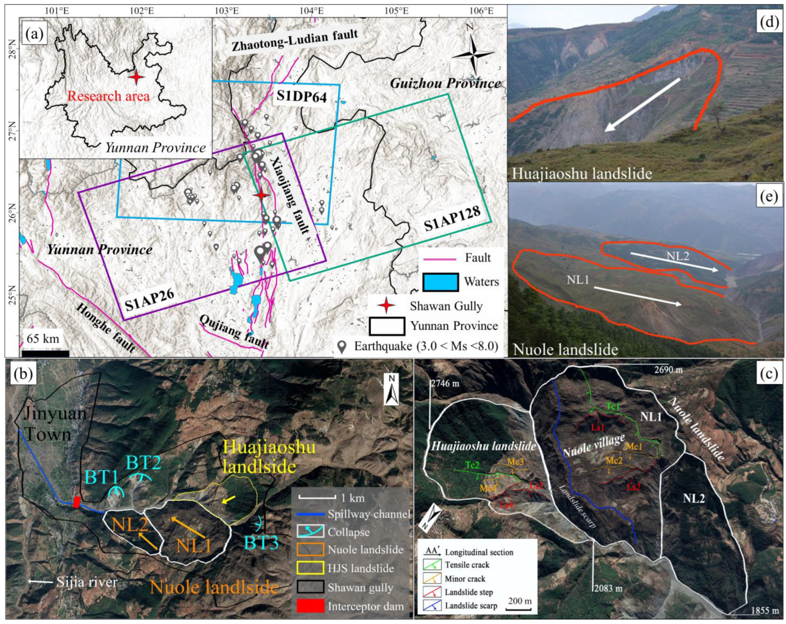
2.1. Study Area
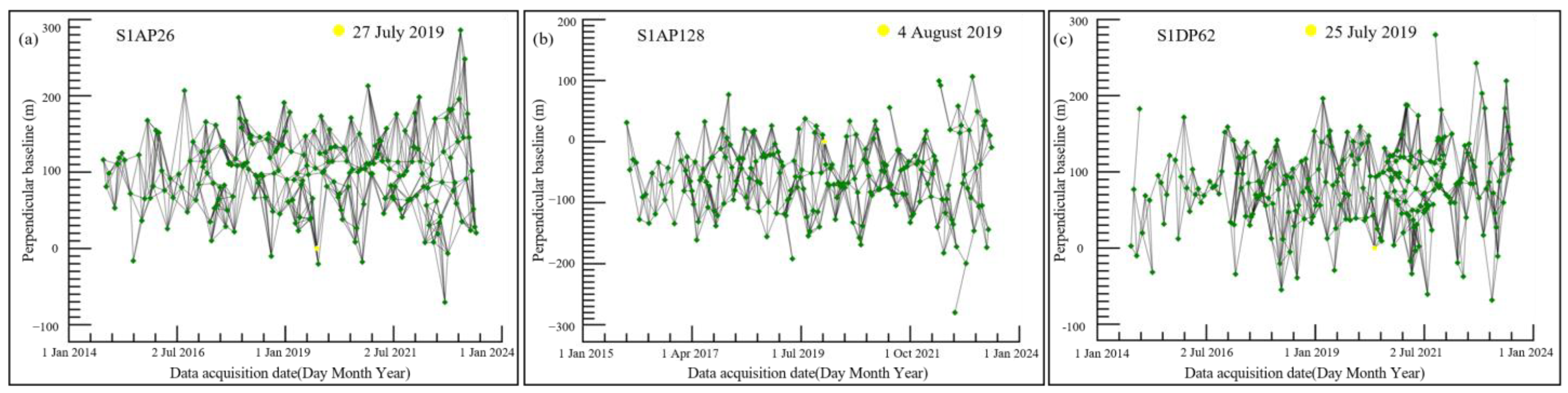
2.2. Datasets
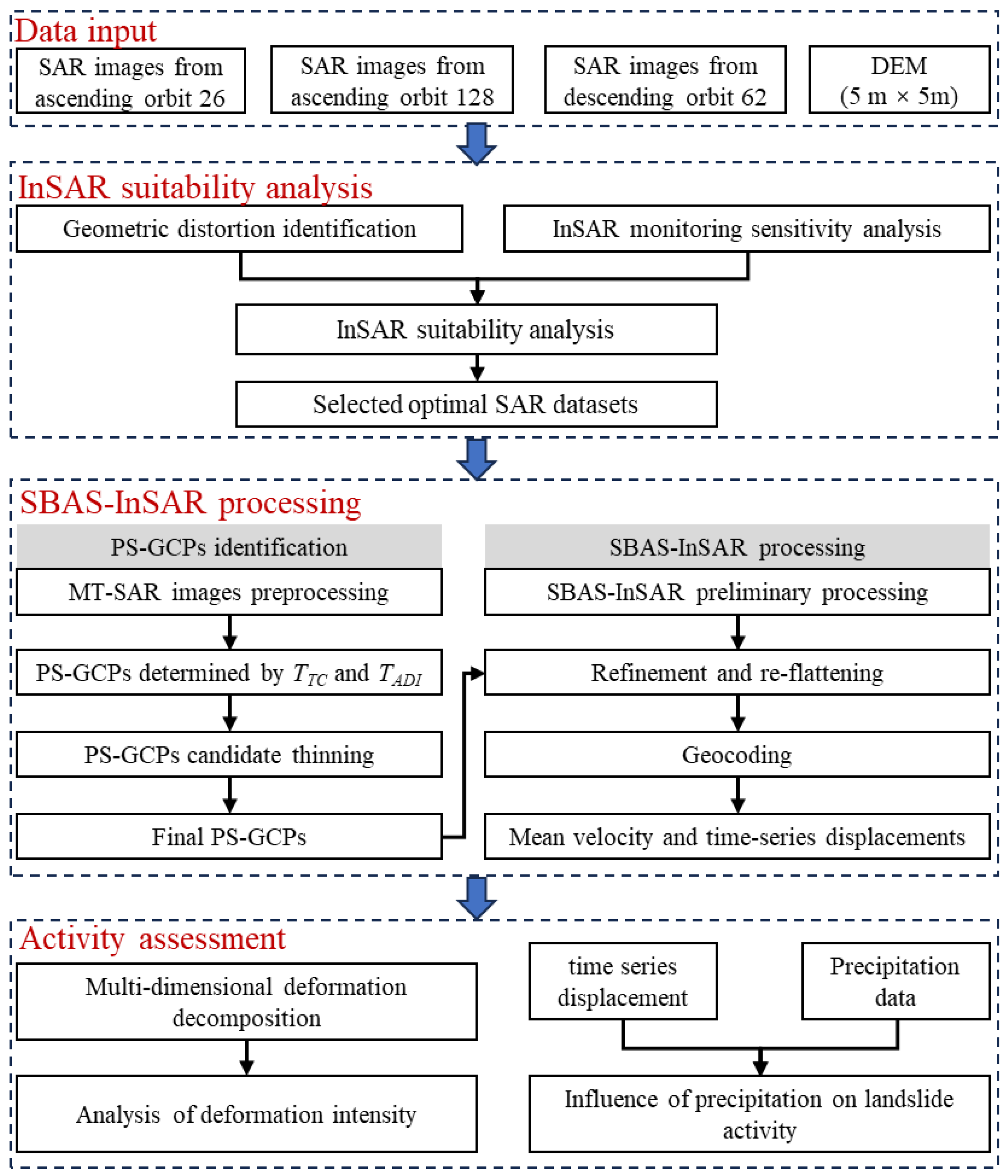
3. Materials and Methods
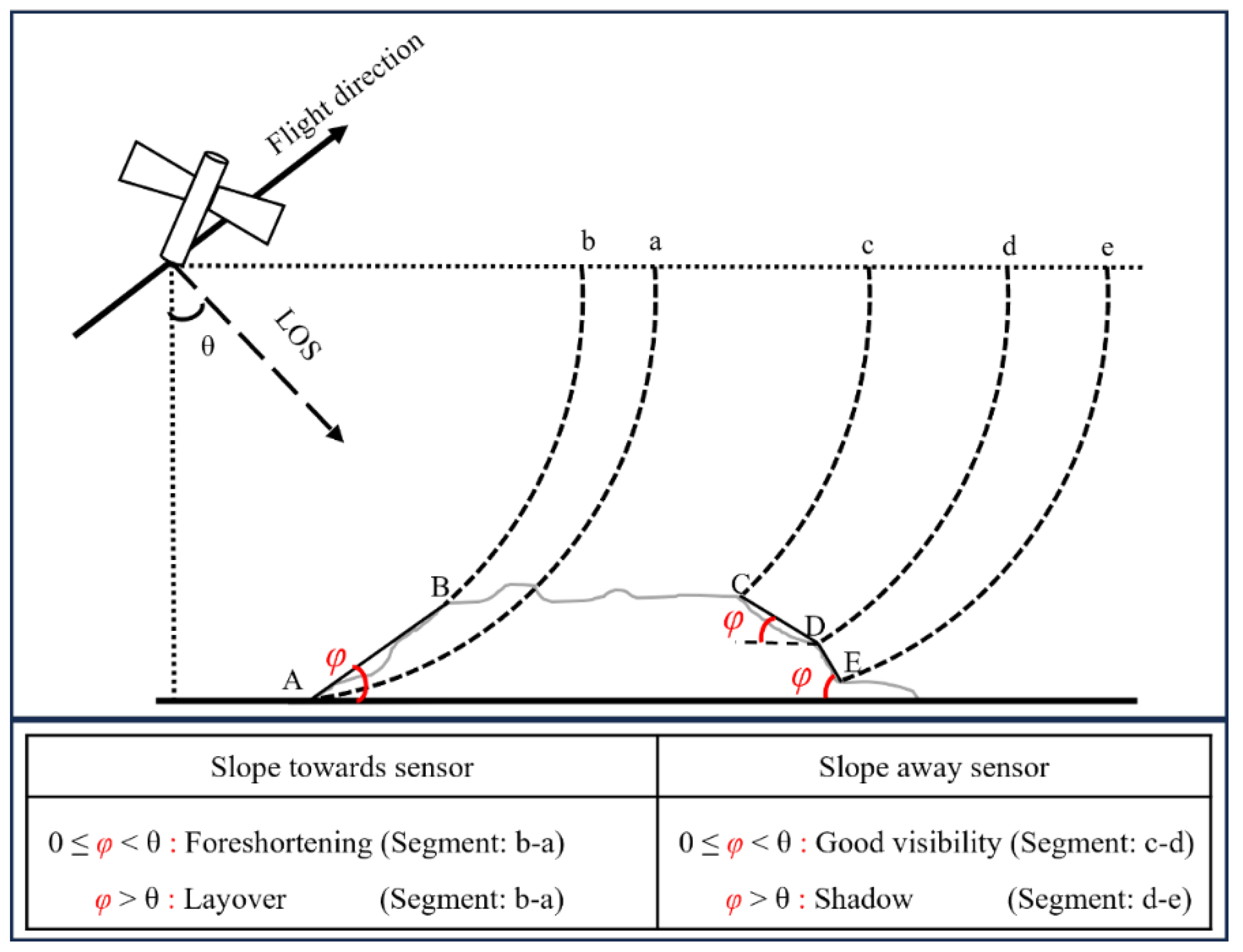
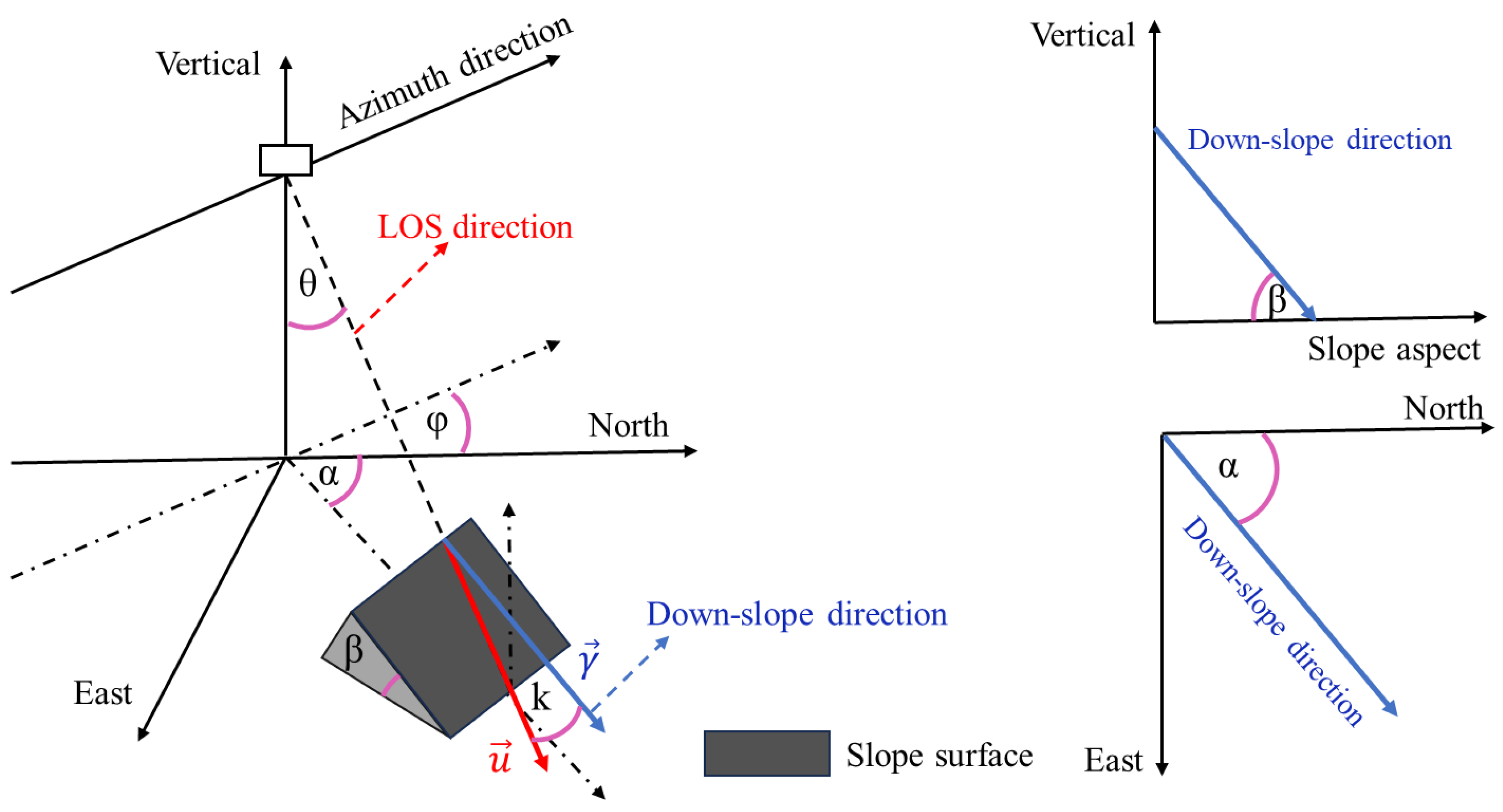
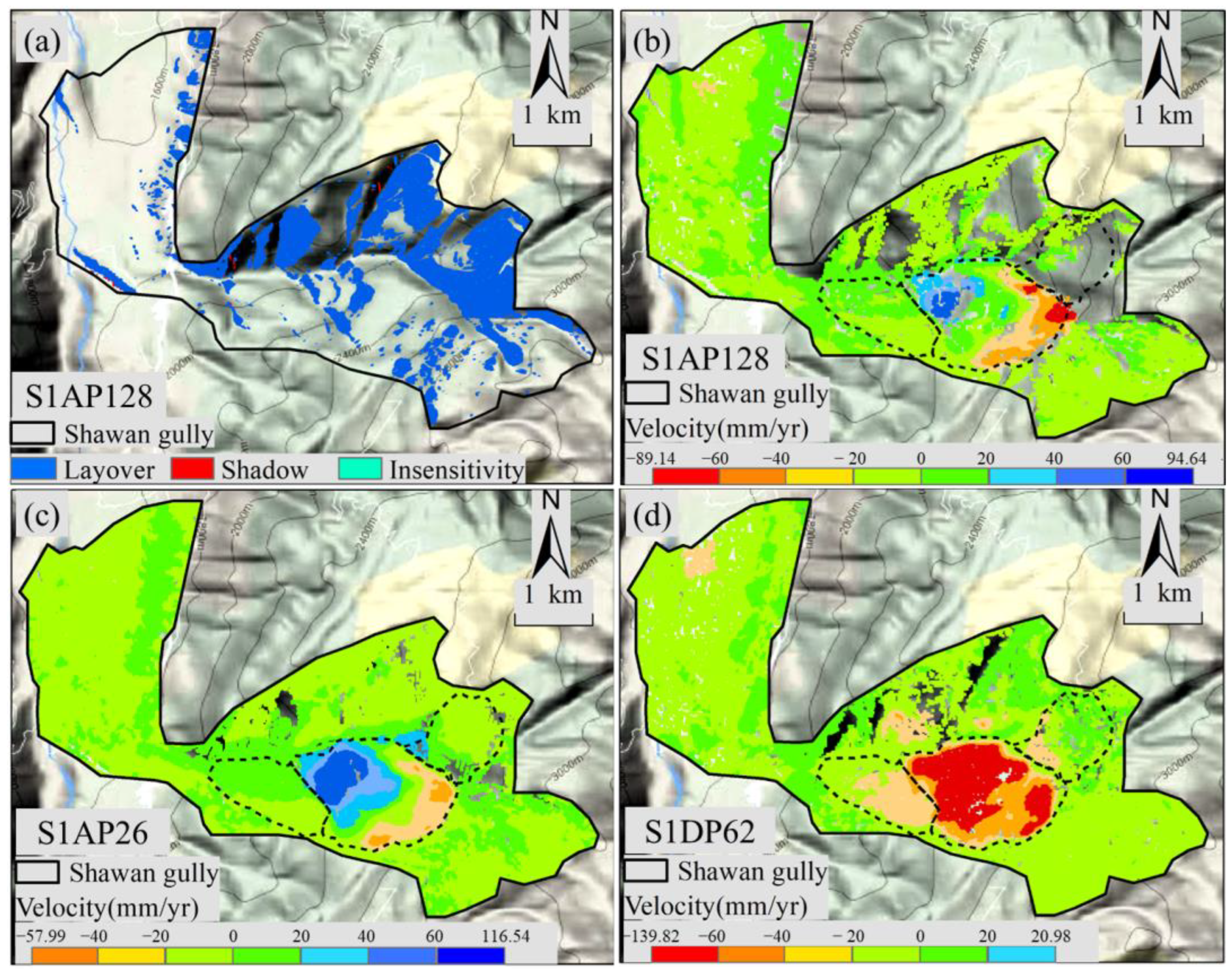
3.1. Geometric Distortion Identification
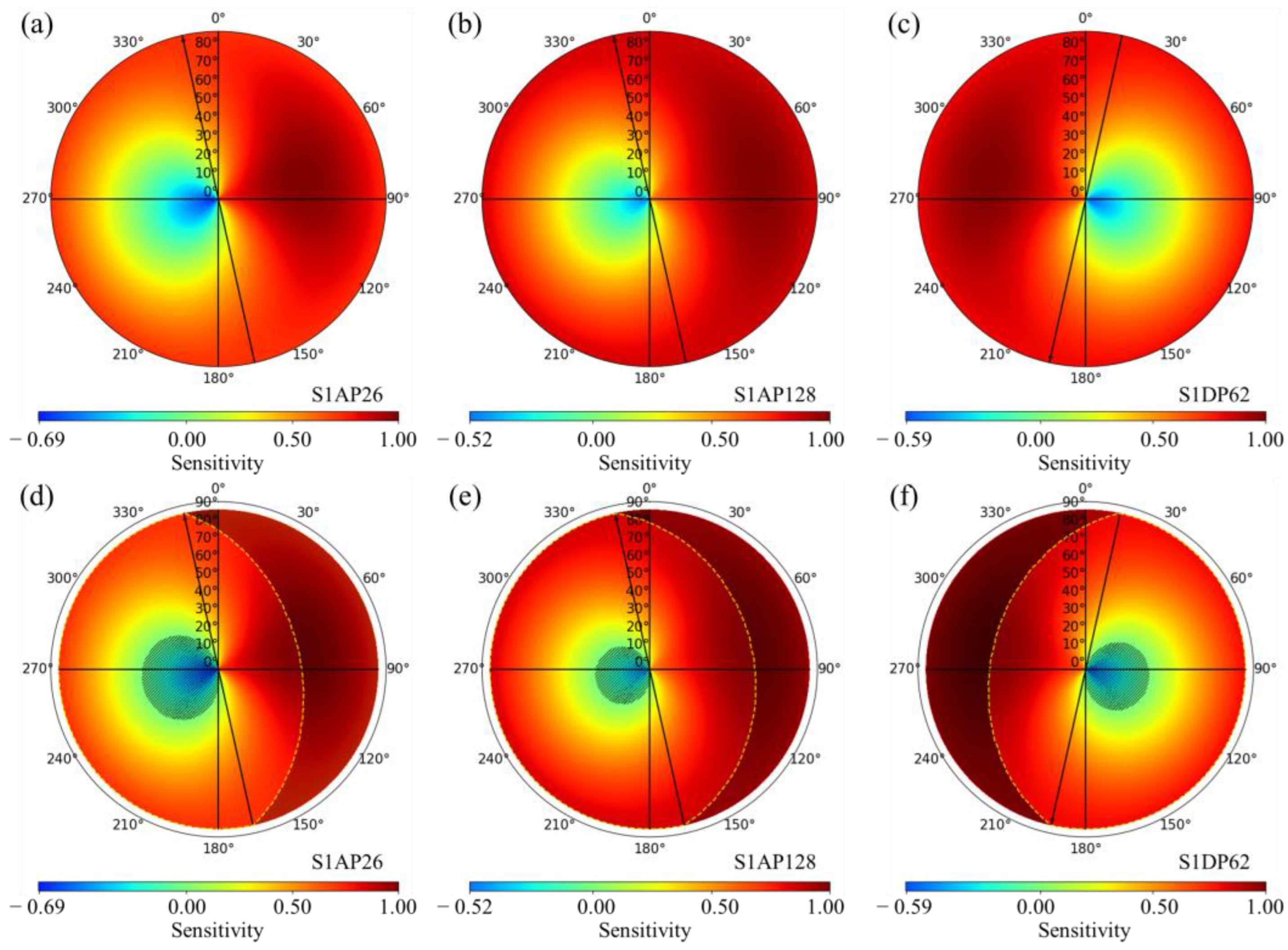
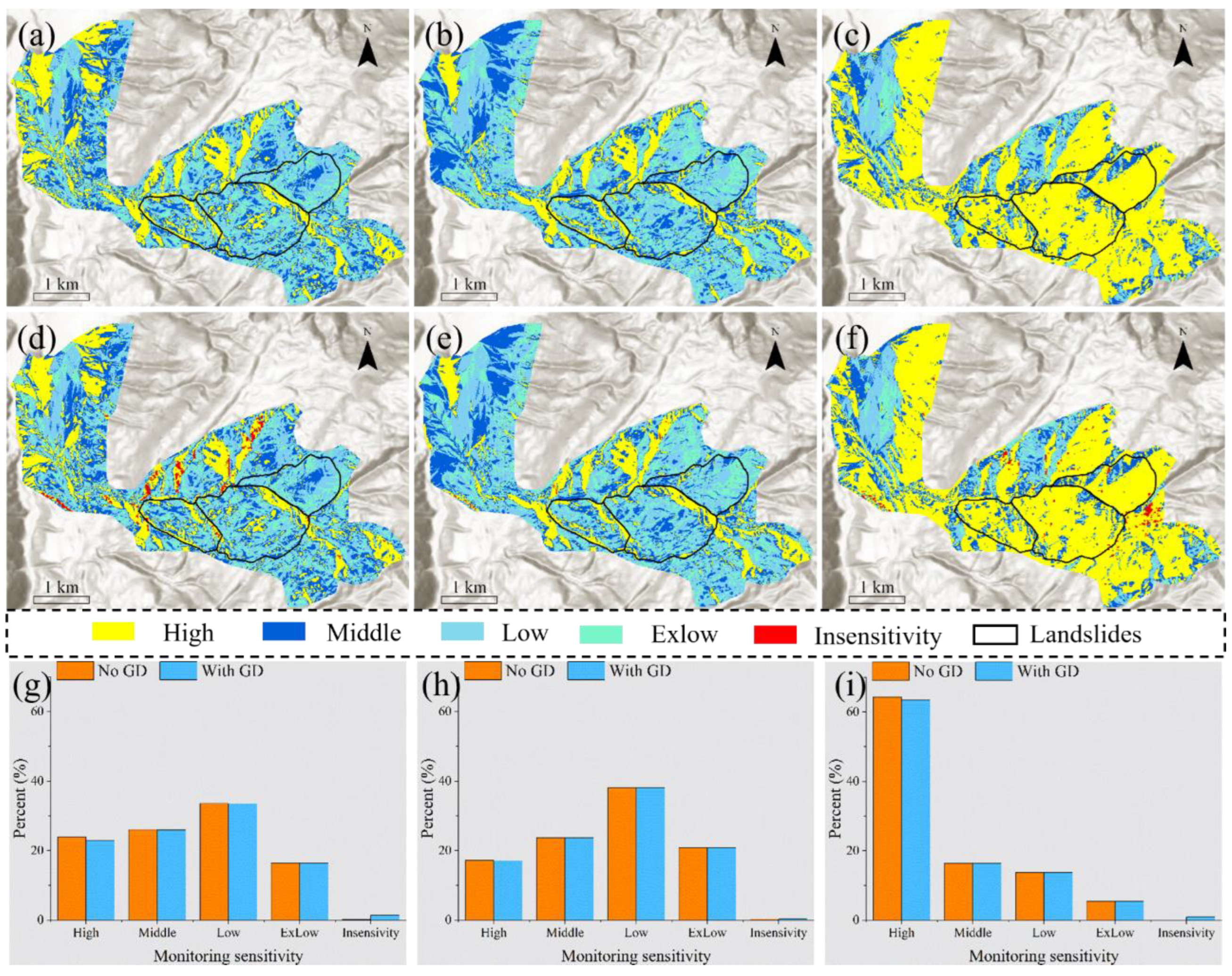
3.2. InSAR Monitoring Sensitivity Analysis
3.3. Surface Deformation Measurements
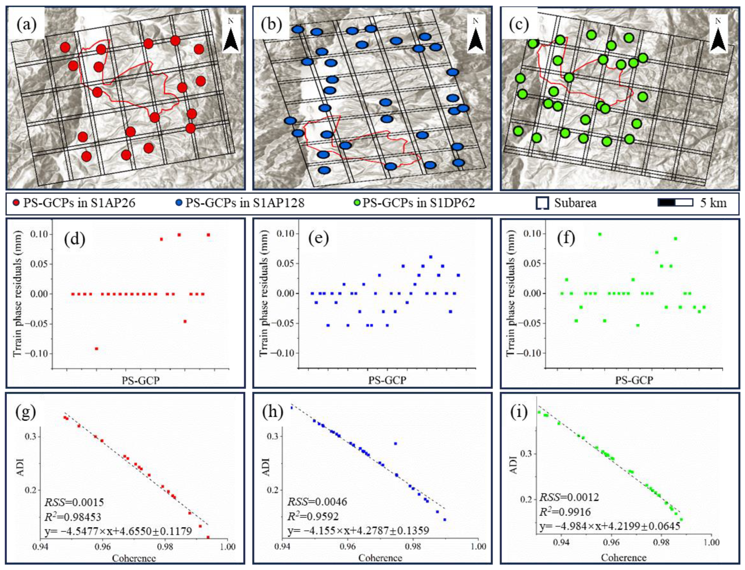
3.3.1. PS-GCPs Selection
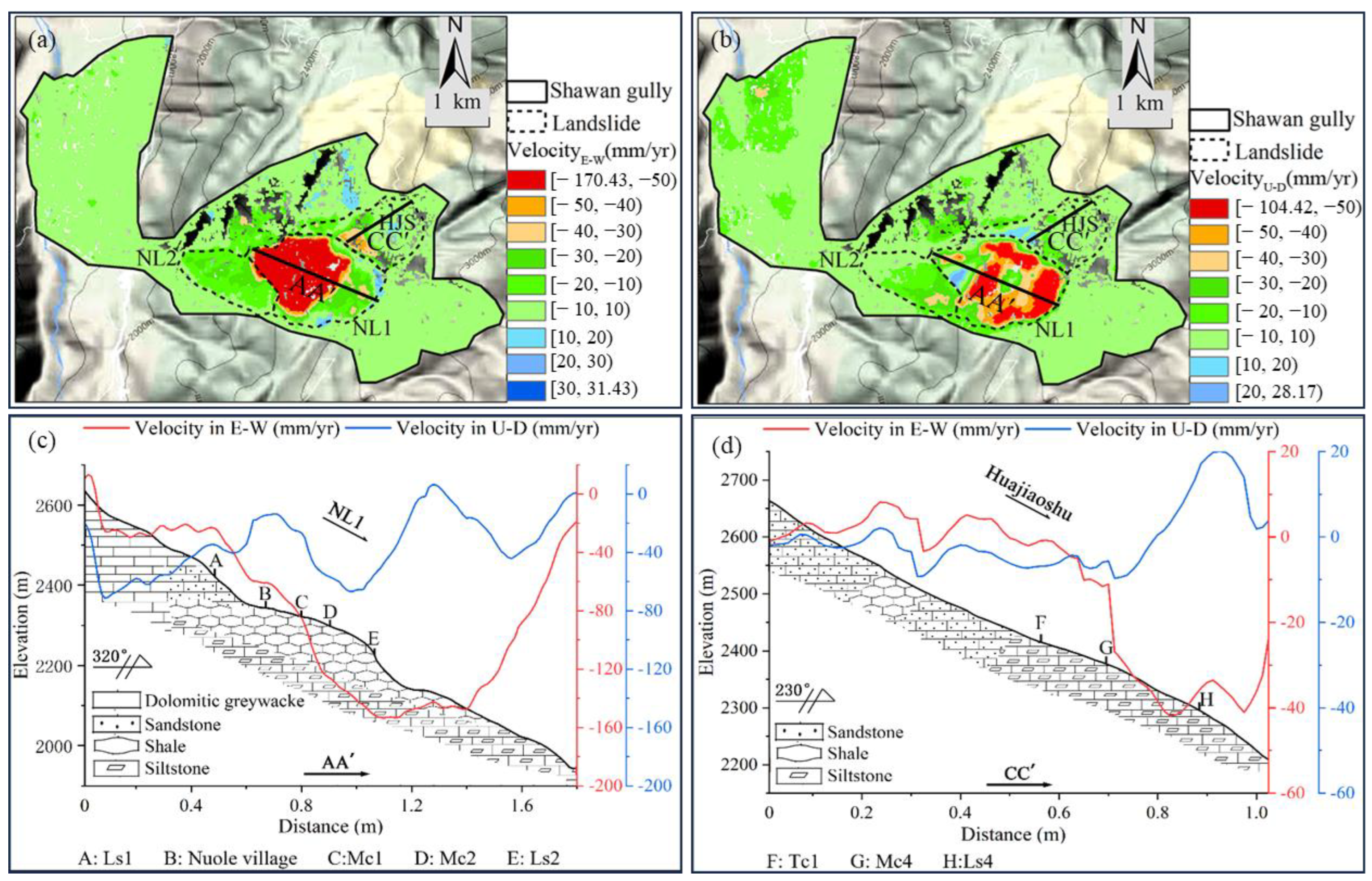
3.3.2. Displacement Components Estimation in Vertical and Horizontal Directions
4. Results
4.1. Suitability Assessment of InSAR Measurements
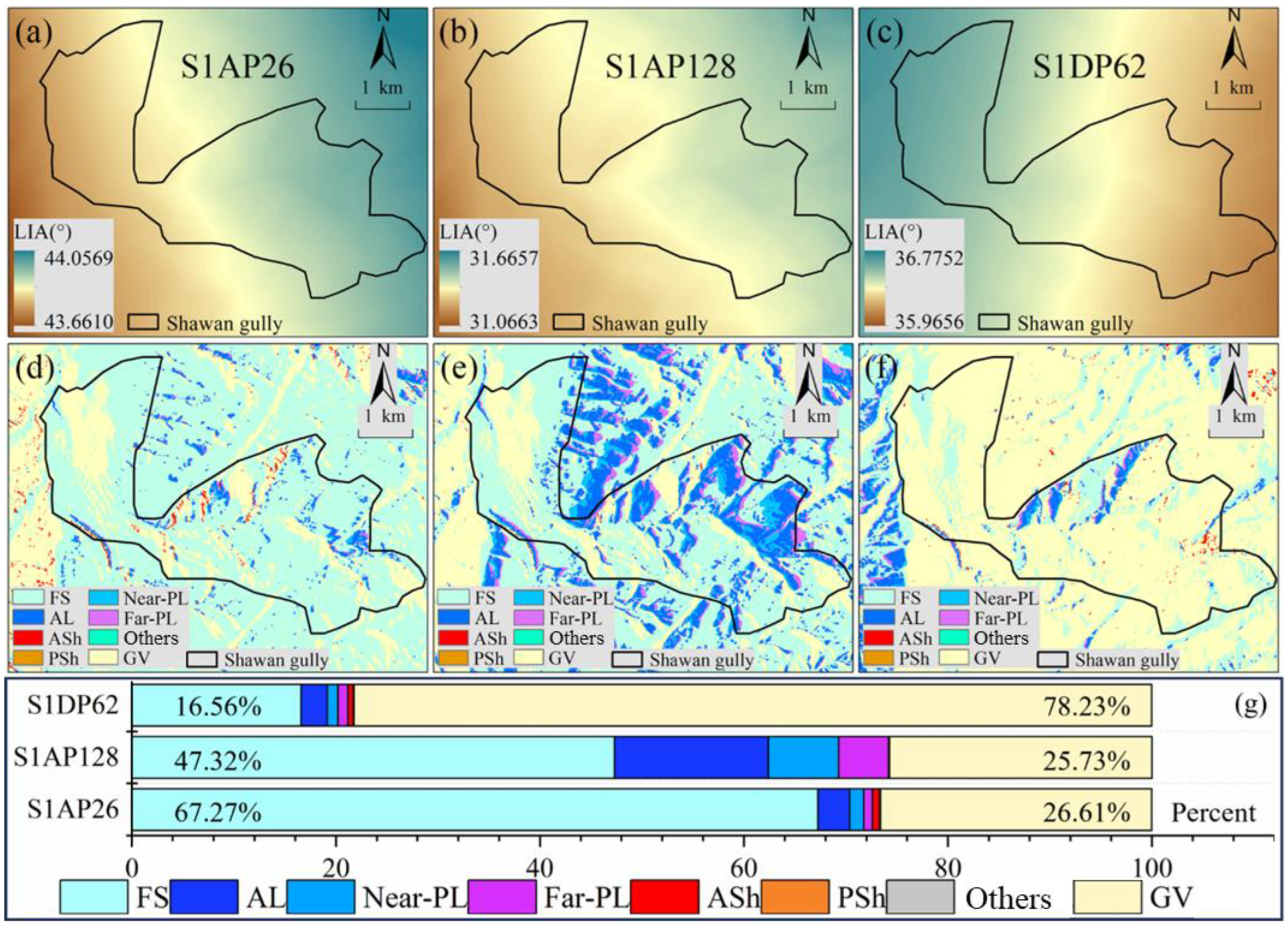
4.1.1. SAR Imagery Availability Analysis
4.1.2. Reliability Analysis of InSAR Measurements
4.2. Deformation Monitoring and Kinematic Patterns Assessment
4.2.1. PS-GCP Detection and Identification
4.2.2. Multi-Orbit SBAS-InSAR Surface Deformation Measurements
4.3. Regional Analysis of Landslide Dynamics
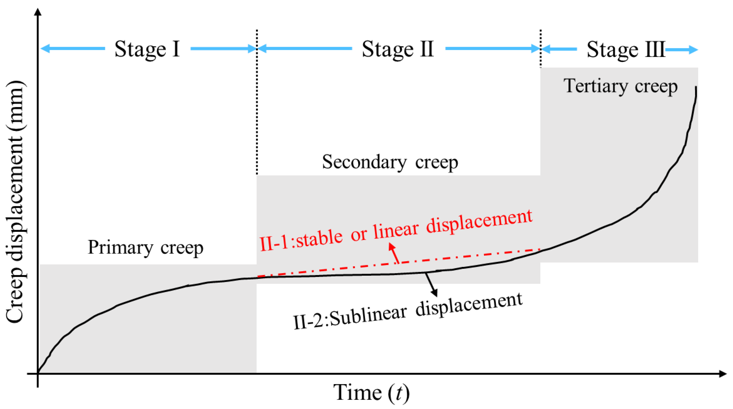
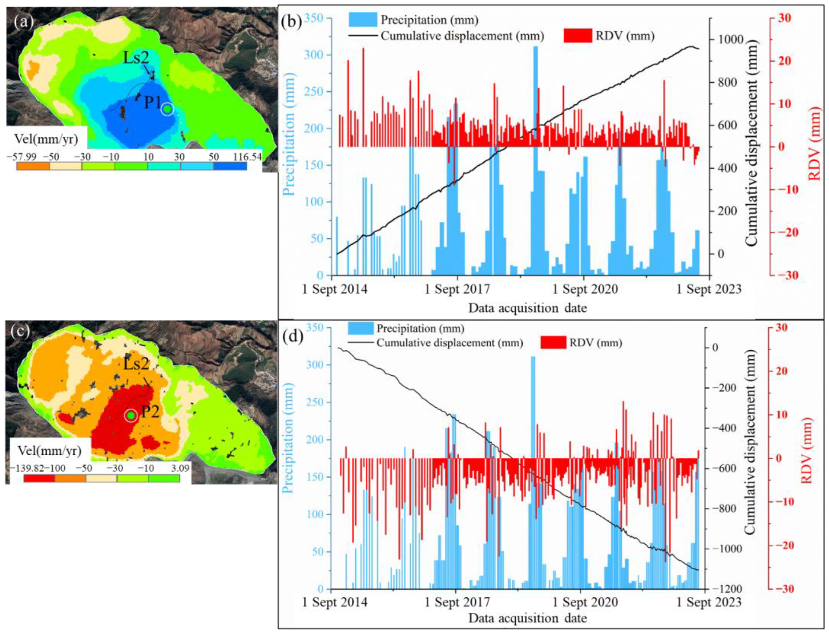
4.4. Rainfall-Induced Changes in Landslide Activity
5. Discussion
- (1)
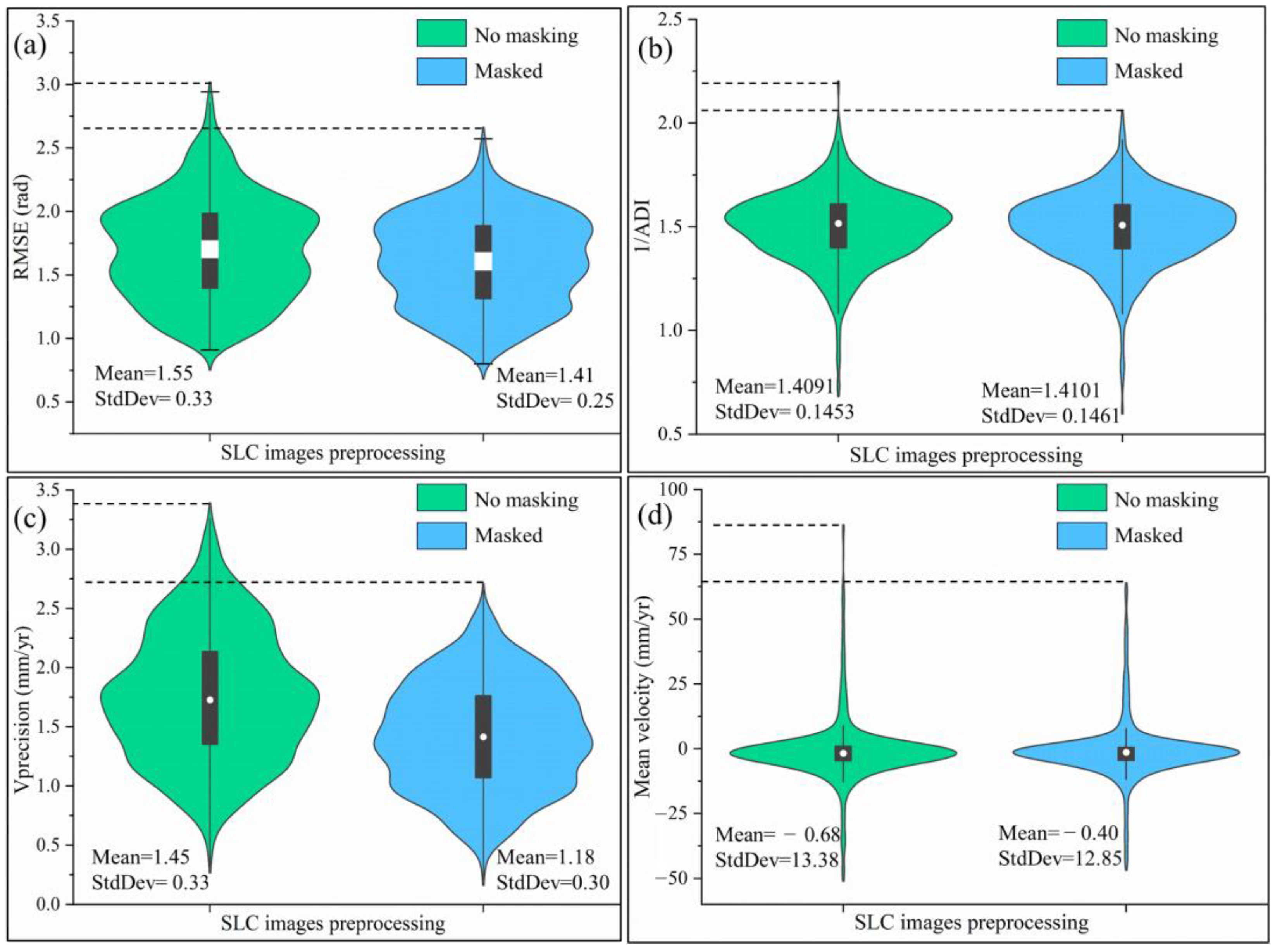
- RMSE: This metric evaluates the phase quality of the interferograms, where a lower RMSE value indicates smaller phase errors and higher quality. Post-masking, the average interferometric phase error decreased from 1.55 rad to 1.41 rad, with the standard deviation reducing from 0.33 to 0.25, signifying a notable reduction in phase error.
- (2)
- 1/ADI: Higher 1/ADI values indicate better phase stability of the pixels and more reliable results. The masking process had minimal impact on the phase mean and standard deviation (1/ADI), with no significant difference observed before and after processing. This suggests that geometric distortions affect the magnitude of interferometric phase errors rather than the phase distribution itself. The result also indicates that reducing sources of phase error is crucial for improving InSAR monitoring quality.
- (3)
- Vprecision: This parameter assesses the precision of deformation measurements, with lower Vprecision values indicating higher measurement accuracy. After masking, the mean Vprecision value decreased from 1.45 mm/year to 1.18 mm/year, and the standard deviation dropped from 0.33 mm to 0.30 mm, demonstrating that masking reduces error and uncertainty, thereby enhancing the precision of deformation rate measurements.
- (4)
- Velocity: Masking reduced the variability in average rate measurements, with the standard deviation of mean velocity dropping from 13.38 mm/yr to 12.85 mm/yr, indicating more concentrated and stable measurement results.
6. Conclusions
- This study used 688 Sentinel-1 SAR scenes collected from three orbits: S1AP26, S1AP128, and S1DP62. Before SBAS-InSAR processing, we proposed a method to evaluate the suitability of the InSAR monitoring scheme based on geometric distortions and monitoring sensitivity. The results show that the SAR imagery from Sentinel-1 ascending path 128 is severely affected by layover and shadow, making it unsuitable for refined monitoring of the Nuole and Huajiaoshu landslides. Among the remaining two orbits, the descending path 62 provides higher reliability for surface deformation monitoring.
- After thinning the ground surface extent, we used SBAS-InSAR to process the refined SAR datasets. To eliminate residual fringes caused by topographical effects, we utilized PS-GCPs with stable phase and high coherence to refine the satellite orbit and re-flatten the interferograms. The refined SBAS-InSAR results of multi-orbits indicate significant surface deformation at the rear scarp and toe of the NL1 section on the Nuole landslide. Additionally, deformation features were observed in the BT2 collapse area, the NL2 section of the Nuole landslide, and the toe of the Huajiaoshu landslide using descending orbit 62 data. For detailed deformation monitoring and analysis of movement characteristics in different regions of the landslide, we estimated the surface deformation rates in both vertical and horizontal directions. The results show significant displacement in the NL1 area in both directions, with consistent movement in the main body of the landslide, while the northern scarp and the foot of the slope exhibited different movement characteristics. Time series displacement demonstrated that rainfall effectively triggers landslide instability and changes the slopes’ movement states, making it a significant factor influencing landslide activity.
- We discussed the role of suitability assessment in enhancing InSAR monitoring accuracy through RMSE, Vprecision, 1/ADI, and Velocity. The mean and standard deviation of RMSE and Vprecision decreased, indicating improved deformation measurement accuracy. The standard deviation of mean deformation velocity decreased from 13.3788 mm/yr to 12.8514 mm/yr, indicating more stable and consistent measurement results. This also confirms that reducing error sources is an effective way to improve InSAR monitoring accuracy. Future research could explore the applicability of these methods in larger and more diverse study areas and investigate other factors that may influence InSAR monitoring accuracy to further enhance the quality and reliability of surface deformation monitoring.
Author Contributions
Funding
Data Availability Statement
Acknowledgments
Conflicts of Interest
References
- Froude, M.J.; Petley, D.N. Global fatal landslide occurrence from 2004 to 2016. Nat. Hazards Earth Syst. Sci. 2018, 18, 2161–2181. [Google Scholar] [CrossRef]
- Ma, S.; Qiu, H.; Hu, S.; Yang, D.; Liu, Z. Characteristics and geomorphology change detection analysis of the Jiangdingya landslide on July 12, 2018, China. Landslides 2021, 18, 383–396. [Google Scholar] [CrossRef]
- Davies, T.; Bloomberg, M.; Palmer, D.; Robinson, T. Debris-flow risk-to-life: Preliminary screening. Int. J. Disaster Risk Reduct. 2024, 100, 104158. [Google Scholar] [CrossRef]
- Zhao, Y.; Meng, X.; Qi, T.; Chen, G.; Li, Y.; Yue, D.; Qing, F. Modeling the Spatial Distribution of Debris Flows and Analysis of the Controlling Factors: A Machine Learning Approach. Remote Sens. 2021, 13, 4813. [Google Scholar] [CrossRef]
- Broeckx, J.; Rossi, M.; Lijnen, K.; Campforts, B.; Poesen, J.; Vanmaercke, M. Landslide mobilization rates: A global analysis and model. Earth-Sci. Rev. 2020, 201, 102972. [Google Scholar] [CrossRef]
- Zhou, W.; Qiu, H.; Wang, L.; Pei, Y.; Tang, B.; Ma, S.; Yang, D.; Cao, M. Combining rainfall-induced shallow landslides and subsequent debris flows for hazard chain prediction. CATENA 2022, 213, 106199. [Google Scholar] [CrossRef]
- Chong, Y.; Chen, G.; Meng, X.; Bian, S.; Huang, F.; Lin, L.; Yue, D.; Zhang, Y.; Guo, F. Formation mechanism and quantitative risk analysis of the landslide-induced hazard chain by an integrated approach for emergency management: A case study in the Bailong River basin, China. CATENA 2023, 233, 107522. [Google Scholar] [CrossRef]
- Hu, X.; Yang, F.; Hu, K.; Ding, M.; Liu, S.; Wei, L. Estimating the debris-flow magnitude using landslide sediment connectivity, Qipan catchment, Wenchuan County, China. CATENA 2023, 220, 106689. [Google Scholar] [CrossRef]
- Chong, Y.; Chen, G.; Meng, X.; Yang, Y.; Shi, W.; Bian, S.; Zhang, Y.; Yue, D. Quantitative analysis of artificial dam failure effects on debris flows—A case study of the Zhouqu ‘8.8’ debris flow in northwestern China. Sci. Total Environ. 2021, 792, 148439. [Google Scholar] [CrossRef]
- Meng, X. Landslides & Debris Flows in Southern Gansu, China and Formation of the Catastrophic Zhouqu Debris Flow Disaster in August 2010. Quat. Int. 2012, 279–280, 322–323. [Google Scholar] [CrossRef]
- Tsuchida, T.; Moriwaki, T.; Nakai, S.; Athapaththu, A.M.R.G. Investigation and consideration on landslide zoning of multiple slope failures and debris flows of 2014 disaster in Hiroshima, Japan. Soils Found. 2019, 59, 1085–1102. [Google Scholar] [CrossRef]
- Wang, F.; Wu, Y.-H.; Yang, H.; Tanida, Y.; Kamei, A. Preliminary investigation of the 20 August 2014 debris flows triggered by a severe rainstorm in Hiroshima City, Japan. Geoenviron. Disasters 2015, 2, 17. [Google Scholar] [CrossRef]
- Carlà, T.; Intrieri, E.; Raspini, F.; Bardi, F.; Farina, P.; Ferretti, A.; Colombo, D.; Novali, F.; Casagli, N. Perspectives on the prediction of catastrophic slope failures from satellite InSAR. Sci. Rep. 2019, 9, 9. [Google Scholar] [CrossRef]
- Wang, X.M.; Yin, J.; Luo, M.H.; Ren, H.F.; Li, J.; Wang, L.Z.; Li, D.D.; Li, G.J. Active High-elevation Landslides in Mao County: Early Identification and Deformational Rules. J. Earth Sci. 2023, 34, 1596–1615. [Google Scholar] [CrossRef]
- Yang, C.; Yin, Y.; Zhang, J.; Ding, P.; Liu, J. A graph deep learning method for landslide displacement prediction based on global navigation satellite system positioning. Geosci. Front. 2024, 15, 101690. [Google Scholar] [CrossRef]
- Lu, Z.; Peng, Y.; Li, W.; Yu, J.; Ge, D.; Han, L.; Xiang, W. An Iterative Classification and Semantic Segmentation Network for Old Landslide Detection Using High-Resolution Remote Sensing Images. IEEE Trans. Geosci. Remote Sens. 2023, 61, 1–13. [Google Scholar] [CrossRef]
- Xu, F.; Wang, B. Debris flow susceptibility mapping in mountainous area based on multi-source data fusion and CNN model—Taking Nujiang Prefecture, China as an example. Int. J. Digit. Earth 2022, 15, 1966–1988. [Google Scholar] [CrossRef]
- Yang, S.; Li, D.; Liu, Y.; Xu, Z.; Sun, Y.; She, X. Landslide Identification in Human-Modified Alpine and Canyon Area of the Niulan River Basin Based on SBAS-InSAR and Optical Images. Remote Sens. 2023, 15, 1998. [Google Scholar] [CrossRef]
- Zhang, Y.; Meng, X.M.; Dijkstra, T.A.; Jordan, C.J.; Chen, G.; Zeng, R.Q.; Novellino, A. Forecasting the magnitude of potential landslides based on InSAR techniques. Remote Sens. Environ. 2020, 241, 111738. [Google Scholar] [CrossRef]
- Li, M.; Zhang, L.; Ding, C.; Li, W.; Luo, H.; Liao, M.; Xu, Q. Retrieval of historical surface displacements of the Baige landslide from time-series SAR observations for retrospective analysis of the collapse event. Remote Sens. Environ. 2020, 240, 111695. [Google Scholar] [CrossRef]
- Sigmundsson, F.; Hooper, A.; Hreinsdottir, S.; Vogfjord, K.S.; Ofeigsson, B.G.; Heimisson, E.R.; Dumont, S.; Parks, M.; Spaans, K.; Gudmundsson, G.B.; et al. Segmented lateral dyke growth in a rifting event at Bardarbunga volcanic system, Iceland. Nature 2015, 517, 191–195. [Google Scholar] [CrossRef] [PubMed]
- Biggs, J.; Wright, T.J. How satellite InSAR has grown from opportunistic science to routine monitoring over the last decade. Nat. Commun. 2020, 11, 3863. [Google Scholar] [CrossRef]
- Bekaert, D.P.S.; Handwerger, A.L.; Agram, P.; Kirschbaum, D.B. InSAR-based detection method for mapping and monitoring slow-moving landslides in remote regions with steep and mountainous terrain: An application to Nepal. Remote Sens. Environ. 2020, 249, 111983. [Google Scholar] [CrossRef]
- Wu, Z.; Xiao, R.; Jiang, M.; Ferreira, V.G. Characterizing the spatial structure and aliasing effect of ocean tide loading on InSAR measurements. Remote Sens. Environ. 2024, 311, 114297. [Google Scholar] [CrossRef]
- Shigemitsu, Y.; Ishitsuka, K.; Lin, W. Changes in widespread aquifer properties caused by a magnitude 6-class earthquake evaluated using InSAR analyses. Int. J. Appl. Earth Obs. Geoinf. 2023, 122, 103394. [Google Scholar] [CrossRef]
- Dong, J.; Zhang, L.; Tang, M.; Liao, M.; Xu, Q.; Gong, J.; Ao, M. Mapping landslide surface displacements with time series SAR interferometry by combining persistent and distributed scatterers: A case study of Jiaju landslide in Danba, China. Remote Sens. Environ. 2018, 205, 180–198. [Google Scholar] [CrossRef]
- Zhu, Z.; Yuan, X.; Gan, S.; Zhang, J.; Zhang, X. A research on a new mapping method for landslide susceptibility based on SBAS-InSAR technology. Egypt. J. Remote Sens. Space Sci. 2023, 26, 1046–1056. [Google Scholar] [CrossRef]
- Du, J.; Li, Z.; Song, C.; Zhu, W.; Tomás, R. Coupling effect of impoundment and irrigation on landslide movement in Maoergai Reservoir area revealed by multi-platform InSAR observations. Int. J. Appl. Earth Obs. Geoinf. 2024, 129, 103802. [Google Scholar] [CrossRef]
- Rosi, A.; Tofani, V.; Tanteri, L.; Stefanelli, C.T.; Agostini, A.; Catani, F.; Casagli, N. The new landslide inventory of Tuscany (Italy) updated with PS-InSAR: Geomorphological features and landslide distribution. Landslides 2018, 15, 5–19. [Google Scholar] [CrossRef]
- Li, Y.F.; Zuo, X.Q.; Zhu, D.M.; Wu, W.H.; Yang, X.; Guo, S.P.; Shi, C.; Huang, C.; Li, F.; Liu, X.Y. Identification and Analysis of Landslides in the Ahai Reservoir Area of the Jinsha River Basin Using a Combination of DS-InSAR, Optical Images, and Field Surveys. Remote Sens. 2022, 14, 6274. [Google Scholar] [CrossRef]
- Cai, J.; Zhang, L.; Dong, J.; Dong, X.; Li, M.; Xu, Q.; Liao, M. Detection and characterization of slow-moving landslides in the 2017 Jiuzhaigou earthquake area by combining satellite SAR observations and airborne Lidar DSM. Eng. Geol. 2022, 305, 106730. [Google Scholar] [CrossRef]
- Seppi, S.A.; López-Martinez, C.; Joseau, M.J. Assessment of L-Band SAOCOM InSAR Coherence and Its Comparison with C-Band: A Case Study over Managed Forests in Argentina. Remote Sens. 2022, 14, 5652. [Google Scholar] [CrossRef]
- Hu, L.; Tang, X.; Tomás, R.; Li, T.; Zhang, X.; Li, Z.; Yao, J.; Lu, J. Monitoring surface deformation dynamics in the mining subsidence area using LT-1 InSAR interferometry: A case study of Datong, China. Int. J. Appl. Earth Obs. Geoinf. 2024, 131, 103936. [Google Scholar] [CrossRef]
- Feng, S.; Dai, K.; Sun, T.; Deng, J.; Tang, G.; Han, Y.; Ren, W.; Sang, X.; Zhang, C.; Wang, H. Mini-Satellite Fucheng 1 SAR: Interferometry to Monitor Mining-Induced Subsidence and Comparative Analysis with Sentinel-1. Remote Sens. 2024, 16, 3457. [Google Scholar] [CrossRef]
- Dun, J.; Feng, W.; Yi, X.; Zhang, G.; Wu, M. Detection and Mapping of Active Landslides before Impoundment in the Baihetan Reservoir Area (China) Based on the Time-Series InSAR Method. Remote Sens. 2021, 13, 3213. [Google Scholar] [CrossRef]
- Cigna, F.; Bateson, L.B.; Jordan, C.J.; Dashwood, C. Simulating SAR geometric distortions and predicting Persistent Scatterer densities for ERS-1/2 and ENVISAT C-band SAR and InSAR applications: Nationwide feasibility assessment to monitor the landmass of Great Britain with SAR imagery. Remote Sens. Environ. 2014, 152, 441–466. [Google Scholar] [CrossRef]
- Guo, R.; Li, S.; Chen, Y.; Li, X.; Yuan, L. Identification and monitoring landslides in Longitudinal Range-Gorge Region with InSAR fusion integrated visibility analysis. Landslides 2020, 18, 551–568. [Google Scholar] [CrossRef]
- Cook, M.E.; Brook, M.S.; Hamling, I.J.; Cave, M.; Tunnicliffe, J.F.; Holley, R. Investigating slow-moving shallow soil landslides using Sentinel-1 InSAR data in Gisborne, New Zealand. Landslides 2023, 20, 427–446. [Google Scholar] [CrossRef]
- Xiong, Z.; Feng, G.; Feng, Z.; Miao, L.; Wang, Y.; Yang, D.; Luo, S. Pre- and post-failure spatial-temporal deformation pattern of the Baige landslide retrieved from multiple radar and optical satellite images. Eng. Geol. 2020, 279, 105880. [Google Scholar] [CrossRef]
- Dai, K.R.; Deng, J.; Xu, Q.; Li, Z.H.; Shi, X.L.; Hancock, C.; Wen, N.L.; Zhang, L.L.; Zhuo, G.C. Interpretation and sensitivity analysis of the InSAR line of sight displacements in landslide measurements. GISci. Remote Sens. 2022, 59, 1226–1242. [Google Scholar] [CrossRef]
- Liu, X.; Zhao, C.; Yin, Y.; Tomás, R.; Zhang, J.; Zhang, Q.; Wei, Y.; Wang, M.; Lopez-Sanchez, J.M. Refined InSAR method for mapping and classification of active landslides in a high mountain region: Deqin County, southern Tibet Plateau, China. Remote Sens. Environ. 2024, 304, 114030. [Google Scholar] [CrossRef]
- Qu, W.; Liu, B.; Zhang, Q.; Gao, Y.; Chen, H.; Wang, Q.; Hao, M. Sentinel-1 InSAR observations of co- and post-seismic deformation mechanisms of the 2016 Mw 5.9 Menyuan Earthquake, Northwestern China. Adv. Space Res. 2021, 68, 1301–1317. [Google Scholar] [CrossRef]
- Xu, Q.; Zhang, S.; Li, W. Spatial distribution of large-scale landslides induced by the 5.12 Wenchuan Earthquake. J. Mt. Sci. 2011, 8, 246–260. [Google Scholar] [CrossRef]
- Song, X.; Jiang, Y.; Shan, X.; Qu, C. Deriving 3D coseismic deformation field by combining GPS and InSAR data based on the elastic dislocation model. Int. J. Appl. Earth Obs. Geoinf. 2017, 57, 104–112. [Google Scholar] [CrossRef]
- Liu, X.; Zhao, C.; Zhang, Q.; Yin, Y.; Lu, Z.; Samsonov, S.; Yang, C.; Wang, M.; Tomás, R. Three-dimensional and long-term landslide displacement estimation by fusing C- and L-band SAR observations: A case study in Gongjue County, Tibet, China. Remote Sens. Environ. 2021, 267, 112745. [Google Scholar] [CrossRef]
- Feng, Y.; Zhou, Y.; Chen, Y.; Li, P.; Xi, M.; Tong, X. Automatic selection of permanent scatterers-based GCPs for refinement and reflattening in InSAR DEM generation. Int. J. Digit. Earth 2022, 15, 954–974. [Google Scholar] [CrossRef]
- Sun, S.; Wang, J.; Li, P. The Forming Condition and Developing Tendency of Debris-flow in Shawan Gully. J. Geol. Hazards Environ. Preserv. 2001, 02, 12–15. [Google Scholar]
- Li, F.; Li, S.; Yang, Y.; Li, J.; Yuan, L.; Cheng, R.; Mao, J. Research on the development characteristics of landslide-type debris flow in Shawandagou based on MT-InSAR. Prog. Geophys. 2023, 38, 532–541. [Google Scholar] [CrossRef]
- Wang, S. Risk Assessment of Debris Flow in Jinyuan Township, Tangdian District, Yunnan Province. Master’s Thesis, Chengdu University of Technology, Chengdu, China, 2017; pp. 37–40. [Google Scholar]
- Colesanti, C.; Wasowski, J. Investigating landslides with space-borne Synthetic Aperture Radar (SAR) interferometry. Eng. Geol. 2006, 88, 173–199. [Google Scholar] [CrossRef]
- Yang, F.; An, Y.; Ren, C.; Xu, J.; Li, J.; Li, D.; Peng, Z. Monitoring and analysis of surface deformation in alpine valley areas based on multidimensional InSAR technology. Sci. Rep. 2023, 13, 12896. [Google Scholar] [CrossRef]
- Shi, C.; Zuo, X.; Zhang, J.; Zhu, D.; Li, Y.; Bu, J. Accuracy Assessment of Geometric-Distortion Identification Methods for Sentinel-1 Synthetic Aperture Radar Imagery in Highland Mountainous Regions. Sensors 2024, 24, 2834. [Google Scholar] [CrossRef]
- Ren, T.H.; Gong, W.P.; Bowa, V.M.; Tang, H.M.; Chen, J.; Zhao, F.M. An Improved R-Index Model for Terrain Visibility Analysis for Landslide Monitoring with InSAR. Remote Sens. 2021, 13, 1938. [Google Scholar] [CrossRef]
- Kropatsch, W.G.; Strobl, D. The generation of SAR layover and shadow maps from digital elevation models. IEEE Trans. Geosci. Remote Sens. 1990, 28, 98–107. [Google Scholar] [CrossRef]
- Notti, D.; Herrera, G.; Bianchini, S.; Meisina, C.; García-Davalillo, J.C.; Zucca, F. A methodology for improving landslide PSI data analysis. Int. J. Remote Sens. 2014, 35, 2186–2214. [Google Scholar] [CrossRef]
- He, L.; Pei, P.; Zhang, X.; Qi, J.; Cai, J.; Cao, W.; Ding, R.; Mao, Y. Sensitivity Evaluation of Time Series InSAR Monitoring Results for Landslide Detection. Remote Sens. 2023, 15, 3906. [Google Scholar] [CrossRef]
- Xiong, Z.; Zhang, M.; Ma, J.; Xing, G.; Feng, G.; An, Q. InSAR-based landslide detection method with the assistance of C-index. Landslides 2023, 20, 2709–2723. [Google Scholar] [CrossRef]
- Zhao, C.; Lu, Z.; Zhang, Q.; de la Fuente, J. Large-area landslide detection and monitoring with ALOS/PALSAR imagery data over Northern California and Southern Oregon, USA. Remote Sens. Environ. 2012, 124, 348–359. [Google Scholar] [CrossRef]
- Chang, F.; Dong, S.; Yin, H.; Wu, Z. Using the SBAS InSAR technique to monitor surface deformation in the Kuqa fold-thrust belt, Tarim Basin, NW China. J. Asian Earth Sci. 2022, 231, 105212. [Google Scholar] [CrossRef]
- Jiang, M.; Ding, X.; Li, Z. Hybrid Approach for Unbiased Coherence Estimation for Multitemporal InSAR. IEEE Trans. Geosci. Remote Sens. 2014, 52, 2459–2473. [Google Scholar] [CrossRef]
- Deng, Y.K.; Tian, W.M.; Xiao, T.; Hu, C.; Yang, H. High-Quality Pixel Selection Applied for Natural Scenes in GB-SAR Interferometry. Remote Sens. 2021, 13, 1617. [Google Scholar] [CrossRef]
- Samsonov, S.; d’Oreye, N.; Smets, B. Ground deformation associated with post-mining activity at the French–German border revealed by novel InSAR time series method. Int. J. Appl. Earth Obs. Geoinf. 2013, 23, 142–154. [Google Scholar] [CrossRef]
- Shi, X.; Xu, Q.; Zhang, L.; Zhao, K.; Dong, J.; Jiang, H.; Liao, M. Surface displacements of the Heifangtai terrace in Northwest China measured by X and C-band InSAR observations. Eng. Geol. 2019, 259, 105181. [Google Scholar] [CrossRef]
- Li, M.; Zhang, L.; Yang, M.; Liao, M. Complex surface displacements of the Nanyu landslide in Zhouqu, China revealed by multi-platform InSAR observations. Eng. Geol. 2023, 317, 107069. [Google Scholar] [CrossRef]
- Tang, W.; Gong, Z.; Sun, X.; Liu, Y.a.; Motagh, M.; Li, Z.; Li, J.; Malinowska, A.; Jiang, J.; Wei, L.; et al. Three-dimensional surface deformation from multi-track InSAR and oil reservoir characterization: A case study in the Liaohe Oilfield, northeast China. Int. J. Rock Mech. Min. Sci. 2024, 174, 105637. [Google Scholar] [CrossRef]
- Liu, X.; Zhao, C.; Zhang, Q.; Yang, C.; Zhu, W. Heifangtai loess landslide type and failure mode analysis with ascending and descending Spot-mode TerraSAR-X datasets. Landslides 2020, 17, 205–215. [Google Scholar] [CrossRef]
- Albano, M.; Saroli, M.; Beccaro, L.; Moro, M.; Doumaz, F.; Discenza, M.E.; Del Rio, L.; Rompato, M. Multi-source data analysis to assess the past and present kinematics of the Pisciotta Deep-Seated Gravitational Slope Deformation (southern Italy). Remote Sens. Environ. 2023, 296, 113751. [Google Scholar] [CrossRef]
- Wang, S.; Wu, W.; Wang, J.; Yin, Z.; Cui, D.; Xiang, W. Residual-state creep of clastic soil in a reactivated slow-moving landslide in the Three Gorges Reservoir Region, China. Landslides 2018, 15, 2413–2422. [Google Scholar] [CrossRef]
- Wang, S.; Wang, J.; Wu, W.; Cui, D.; Su, A.; Xiang, W. Creep properties of clastic soil in a reactivated slow-moving landslide in the Three Gorges Reservoir Region, China. Eng. Geol. 2020, 267, 105493. [Google Scholar] [CrossRef]
- Pedrazzini, A.; Jaboyedoff, M.; Loye, A.; Derron, M.-H. From deep seated slope deformation to rock avalanche: Destabilization and transportation models of the Sierre landslide (Switzerland). Tectonophysics 2013, 605, 149–168. [Google Scholar] [CrossRef]
- Chigira, M.; Tsou, C.-Y.; Matsushi, Y.; Hiraishi, N.; Matsuzawa, M. Topographic precursors and geological structures of deep-seated catastrophic landslides caused by Typhoon Talas. Geomorphology 2013, 201, 479–493. [Google Scholar] [CrossRef]


| Path | 26 | 128 | 62 |
|---|---|---|---|
| Flight mode | ascending | ascending | descending |
| Polarization | VV | VV | VV |
| Heading angle (°) | 347.5028 | 347.4863 | 192.5084 |
| Incidence angle (°) | Local incidence angle (LIA) | ||
| Acquisition period | 19 October 2014 to 29 May 2023 | 26 November 2015 to 5 June 2023 | 9 October 2014 to 6 July 2023 |
| Number | 223 | 210 | 255 |
| Sensitivity | [min, −0.5) and (0.5, 1] | [−0.5, −0.3) and (0.3, 0.5] | [−0.3, −0.1) and (0.1, 0.3] | [−0.1, 0) and (0, 0.1] | 0 |
| Classification | High | Middle | Low | Extremely low | insensitivity |
Disclaimer/Publisher’s Note: The statements, opinions and data contained in all publications are solely those of the individual author(s) and contributor(s) and not of MDPI and/or the editor(s). MDPI and/or the editor(s) disclaim responsibility for any injury to people or property resulting from any ideas, methods, instructions or products referred to in the content. |
© 2025 by the authors. Licensee MDPI, Basel, Switzerland. This article is an open access article distributed under the terms and conditions of the Creative Commons Attribution (CC BY) license (https://creativecommons.org/licenses/by/4.0/).
Share and Cite
Zhang, J.; Zuo, X.; Zhu, D.; Li, Y.; Liu, X. Long-Term Monitoring of Landslide Activity in a Debris Flow Gully Using SBAS-InSAR: A Case Study of Shawan Gully, China. Remote Sens. 2025, 17, 1580. https://doi.org/10.3390/rs17091580
Zhang J, Zuo X, Zhu D, Li Y, Liu X. Long-Term Monitoring of Landslide Activity in a Debris Flow Gully Using SBAS-InSAR: A Case Study of Shawan Gully, China. Remote Sensing. 2025; 17(9):1580. https://doi.org/10.3390/rs17091580
Chicago/Turabian StyleZhang, Jianming, Xiaoqing Zuo, Daming Zhu, Yongfa Li, and Xu Liu. 2025. "Long-Term Monitoring of Landslide Activity in a Debris Flow Gully Using SBAS-InSAR: A Case Study of Shawan Gully, China" Remote Sensing 17, no. 9: 1580. https://doi.org/10.3390/rs17091580
APA StyleZhang, J., Zuo, X., Zhu, D., Li, Y., & Liu, X. (2025). Long-Term Monitoring of Landslide Activity in a Debris Flow Gully Using SBAS-InSAR: A Case Study of Shawan Gully, China. Remote Sensing, 17(9), 1580. https://doi.org/10.3390/rs17091580