
Planform Change and Its Delayed Response to Discharge in an Active Braided River Reach: Majuli Island Reach of the Brahmaputra River

 ,
,  , , , ,
  ,
,
Abstract

1. Introduction
2. Materials and Methods
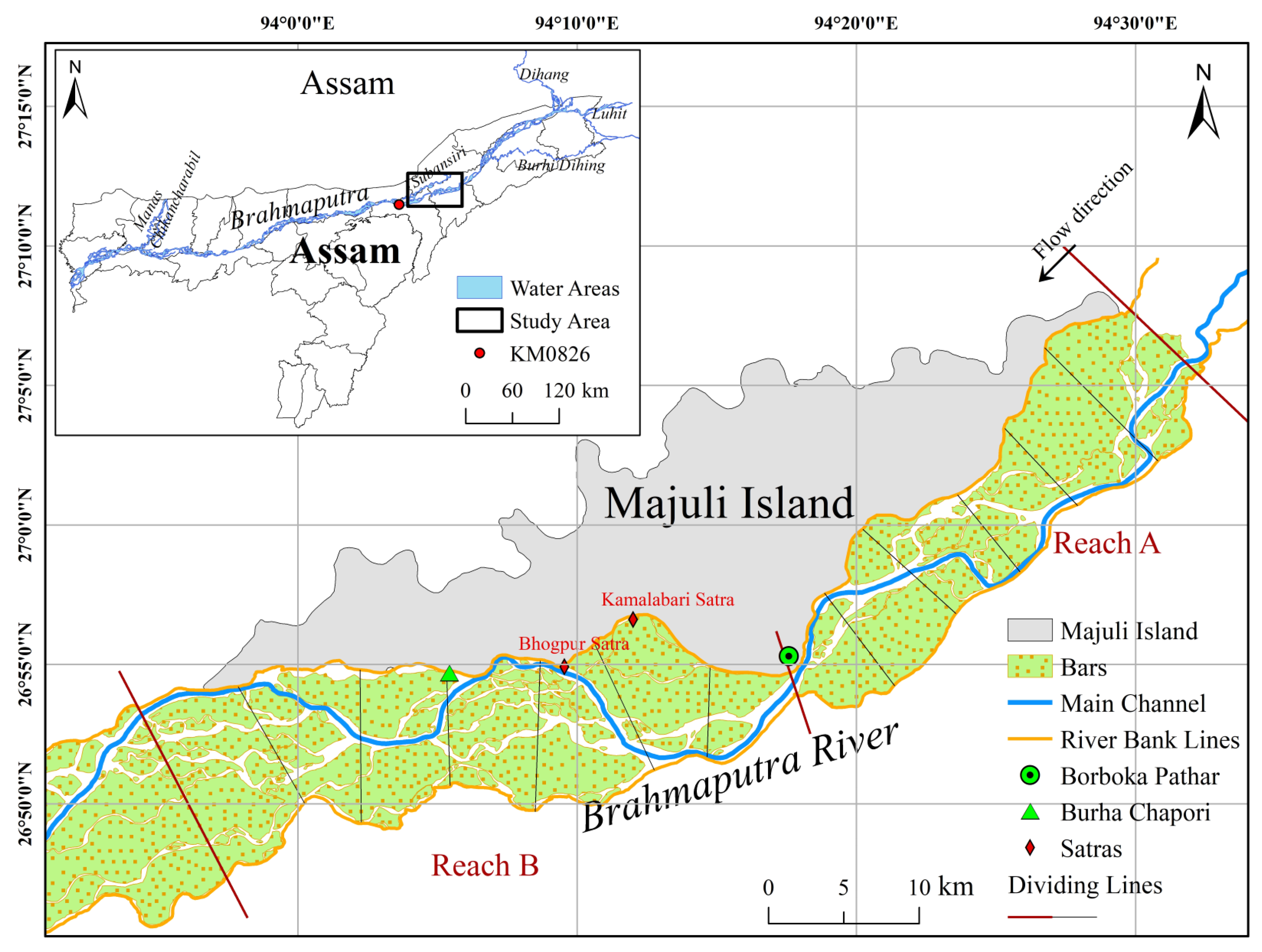
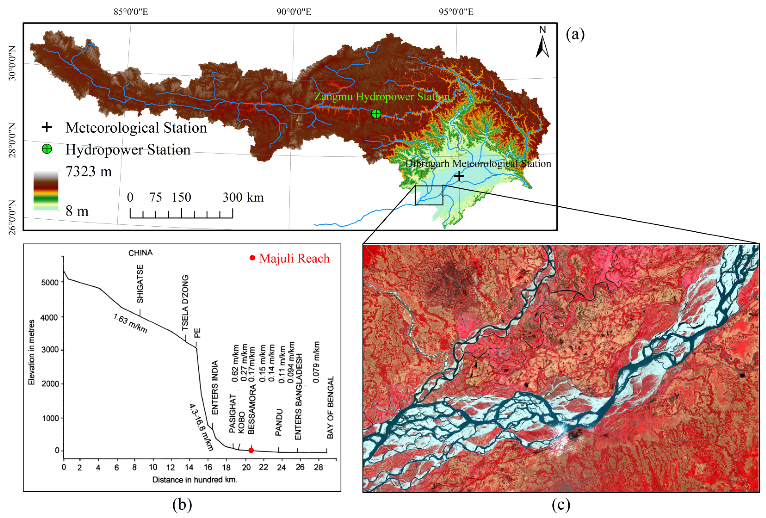
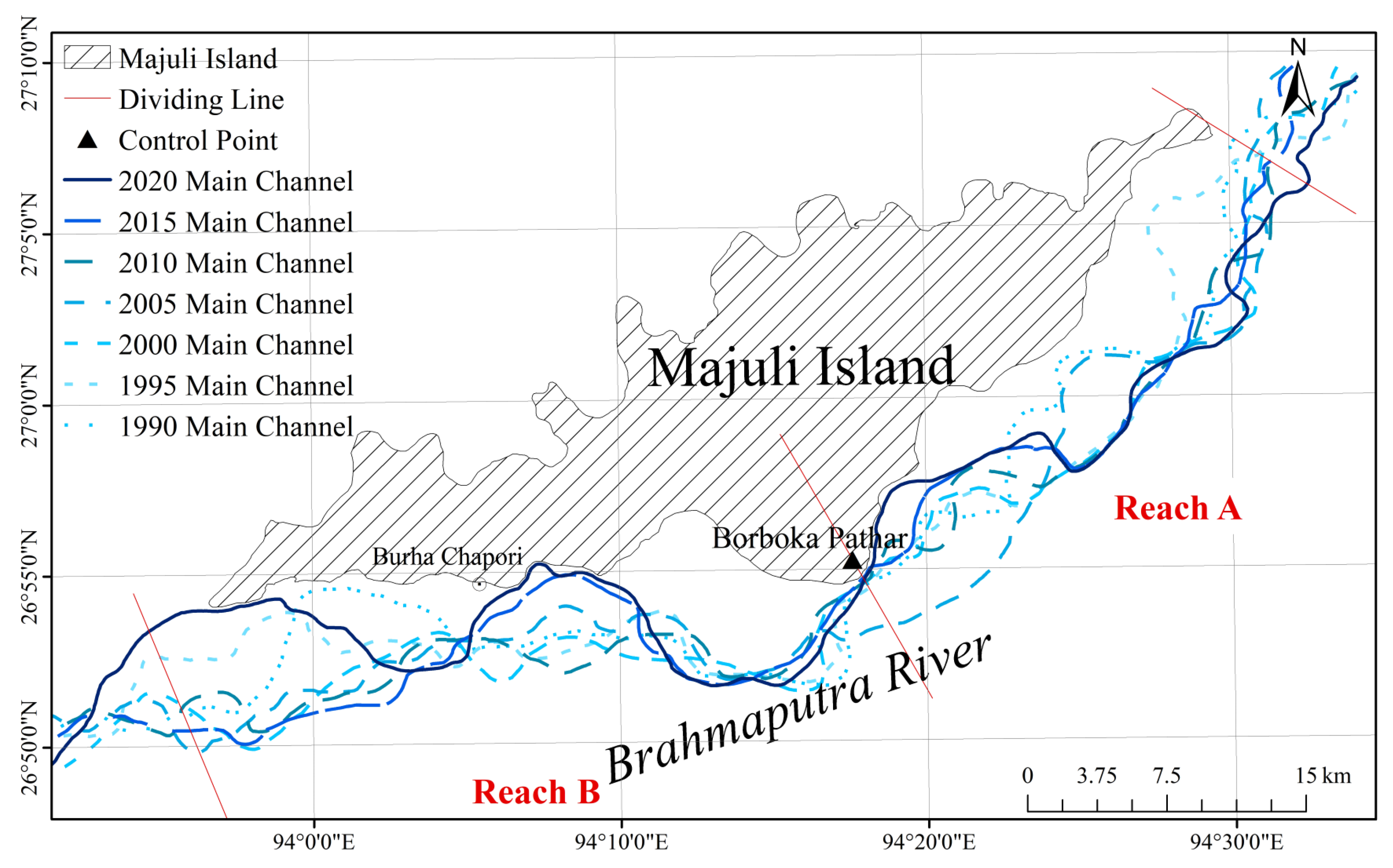
2.1. Study Area
2.2. Data Collection and Processing
2.3. Braided River Morphology Indexes
2.4. Delayed Response and Regression Analysis
3. Results
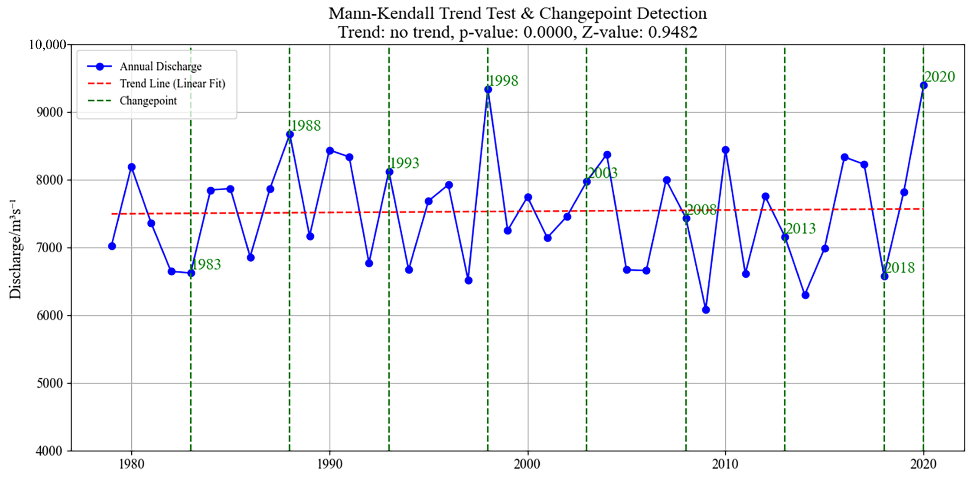
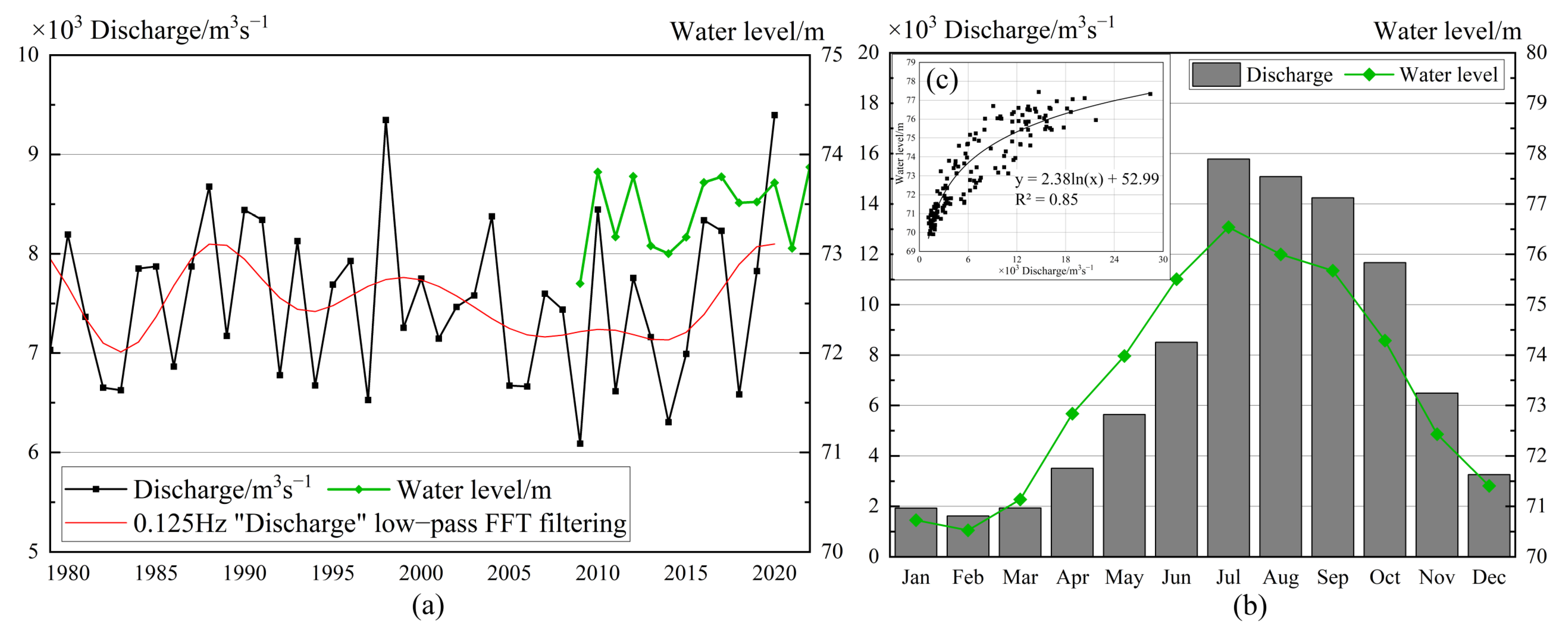
3.1. Hydrological Characteristics
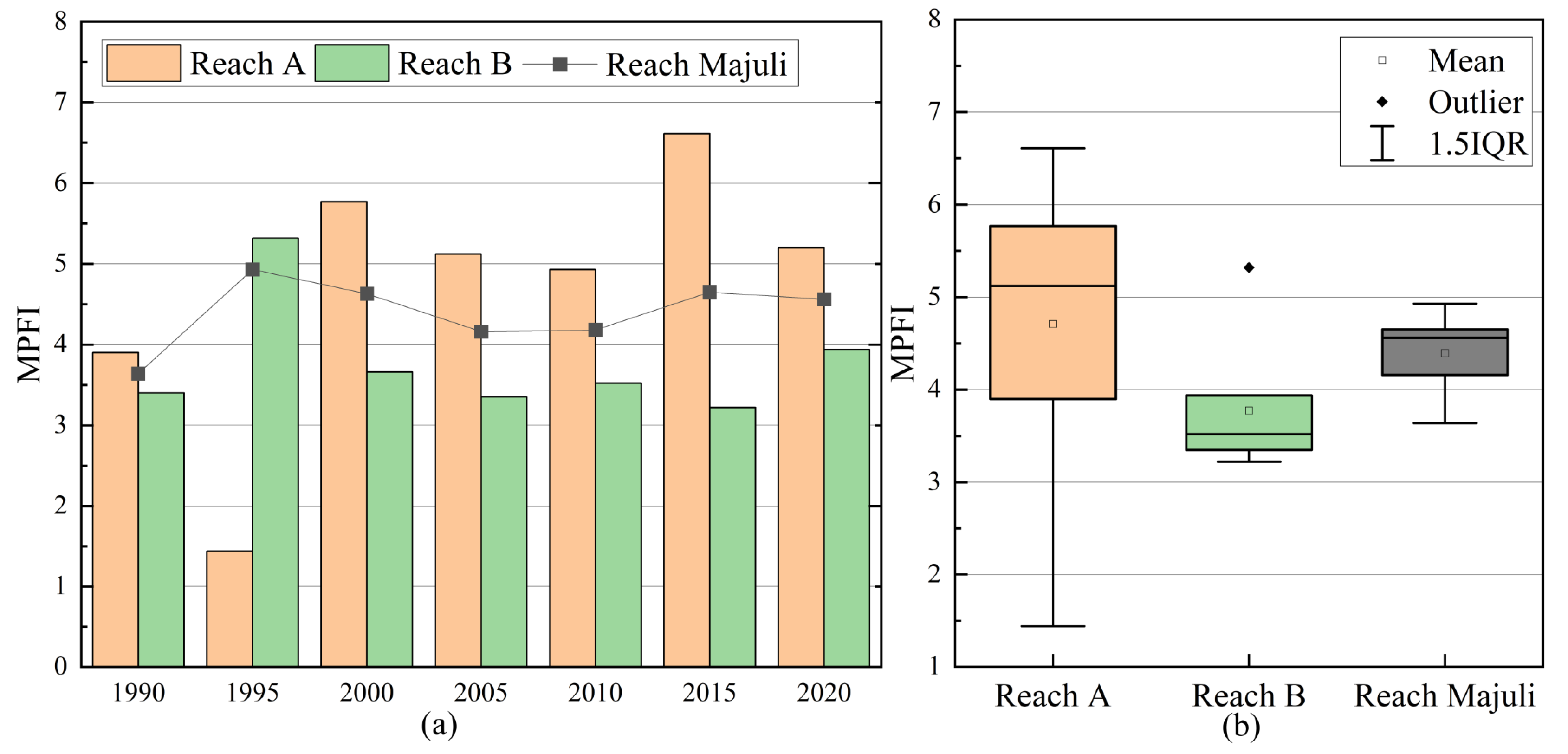
3.2. Changes of Braiding Degree
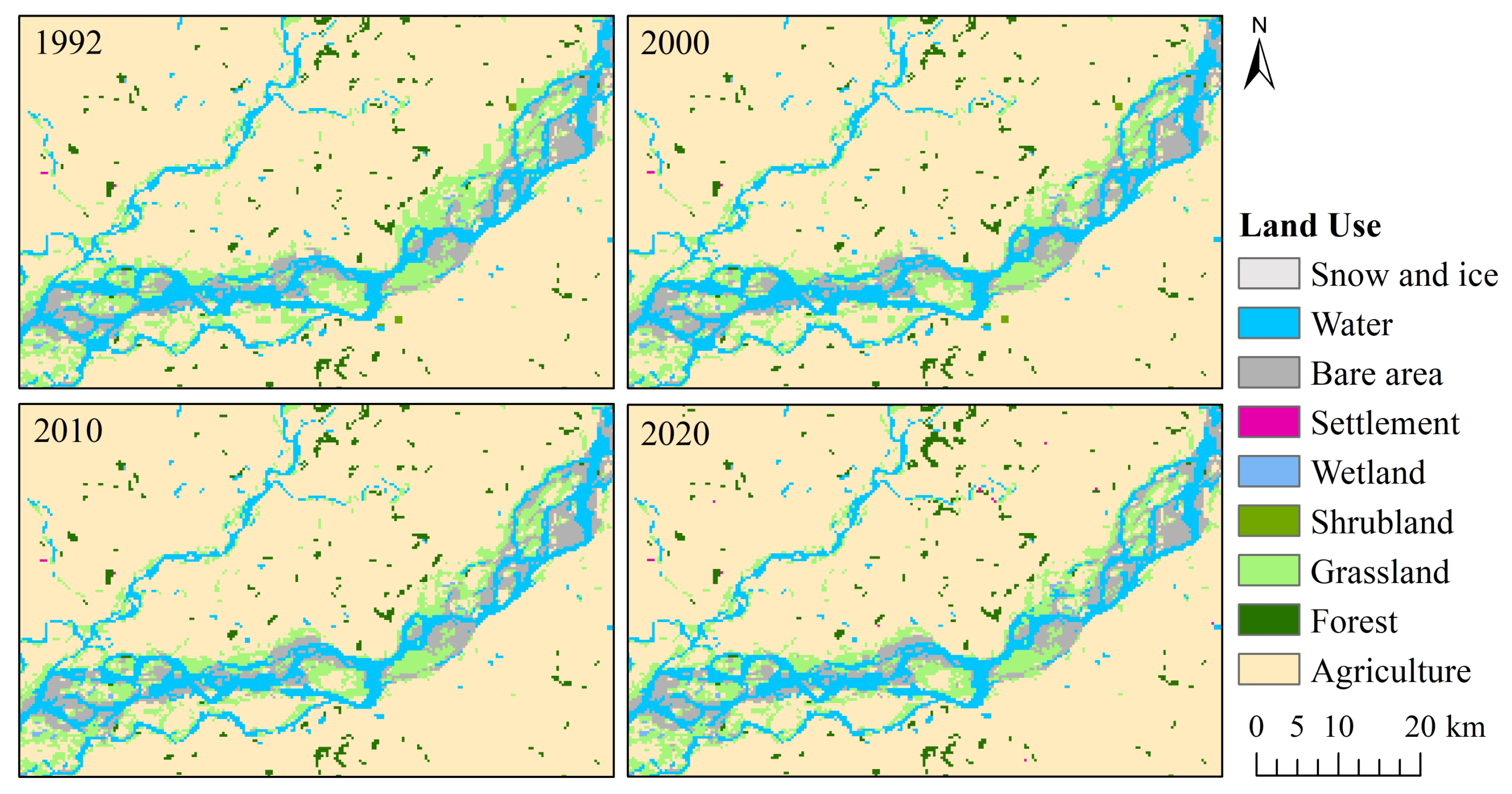
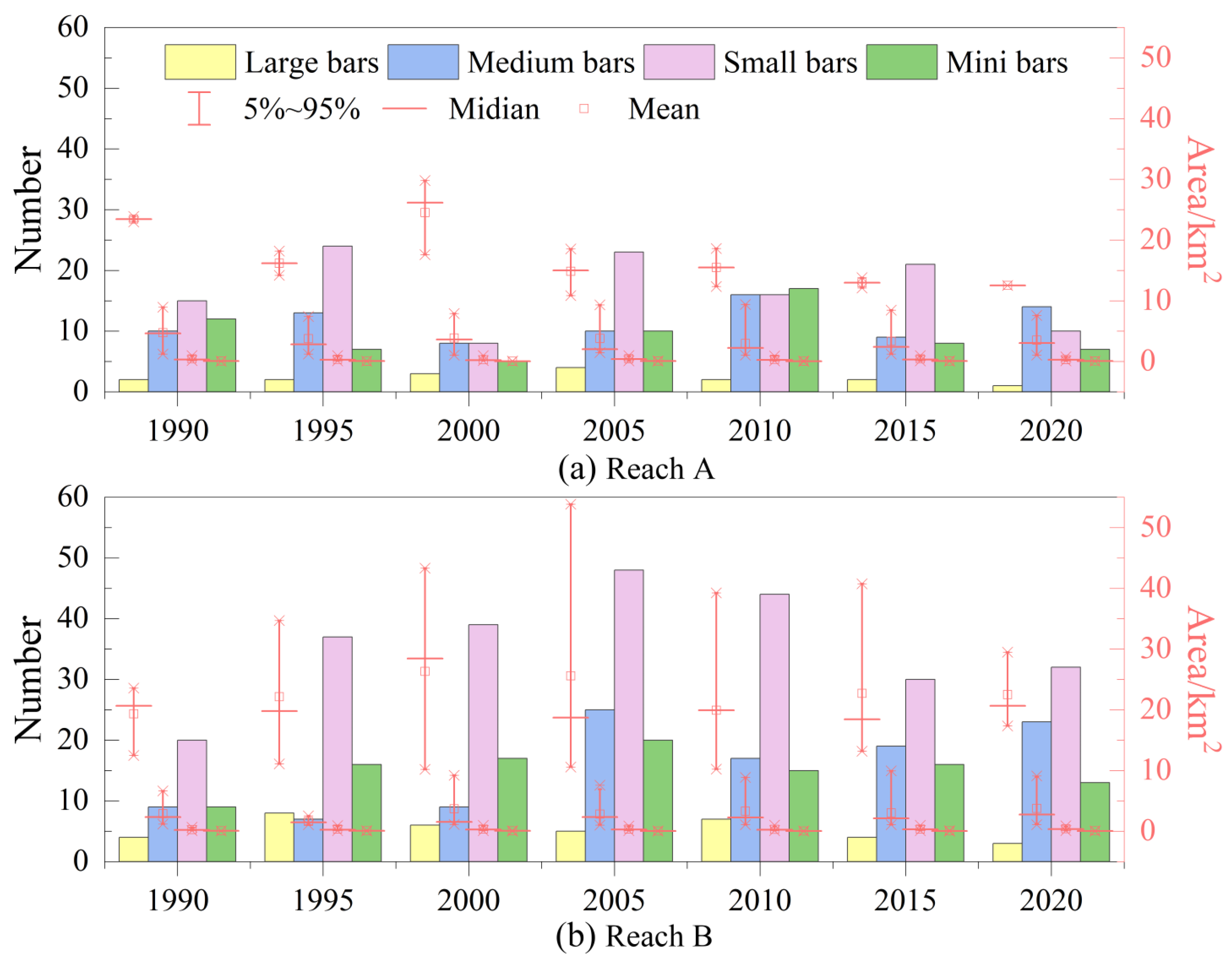
3.3. Spatial and Temporal Variation of Bars and Channels
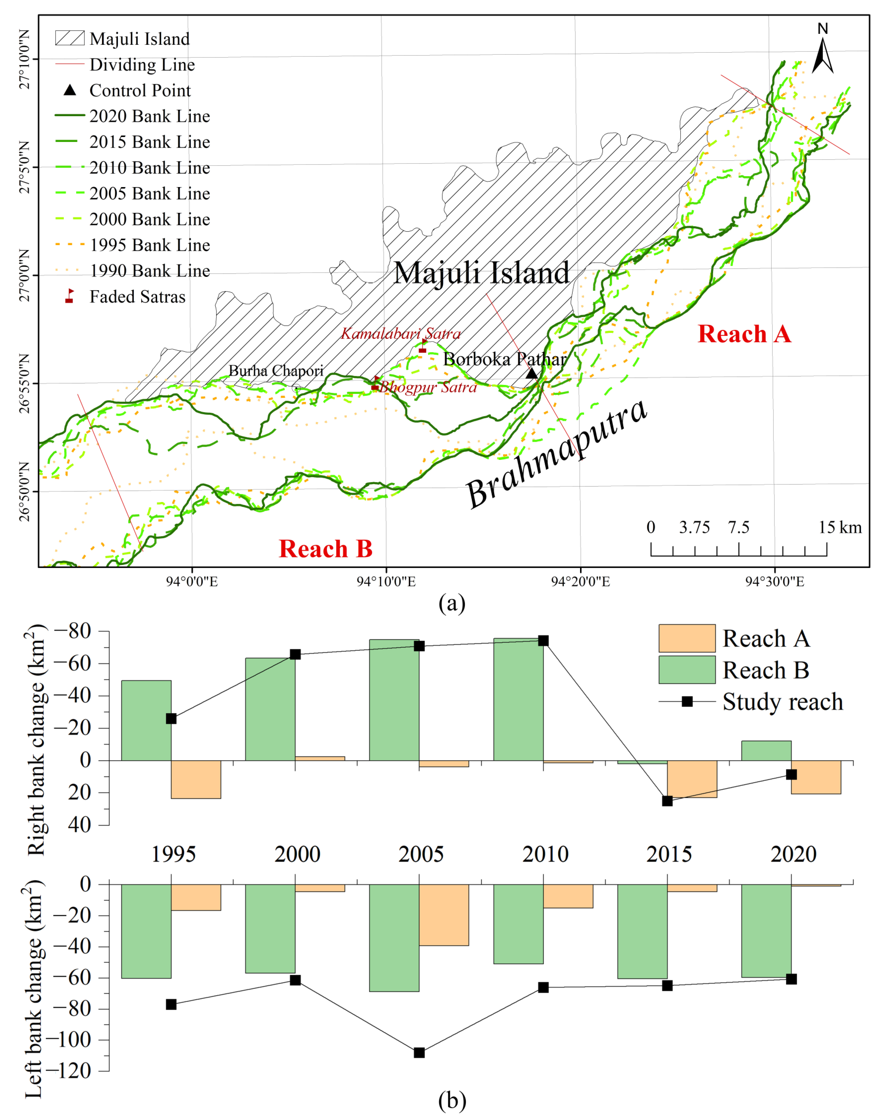
3.4. River Bankline Changes
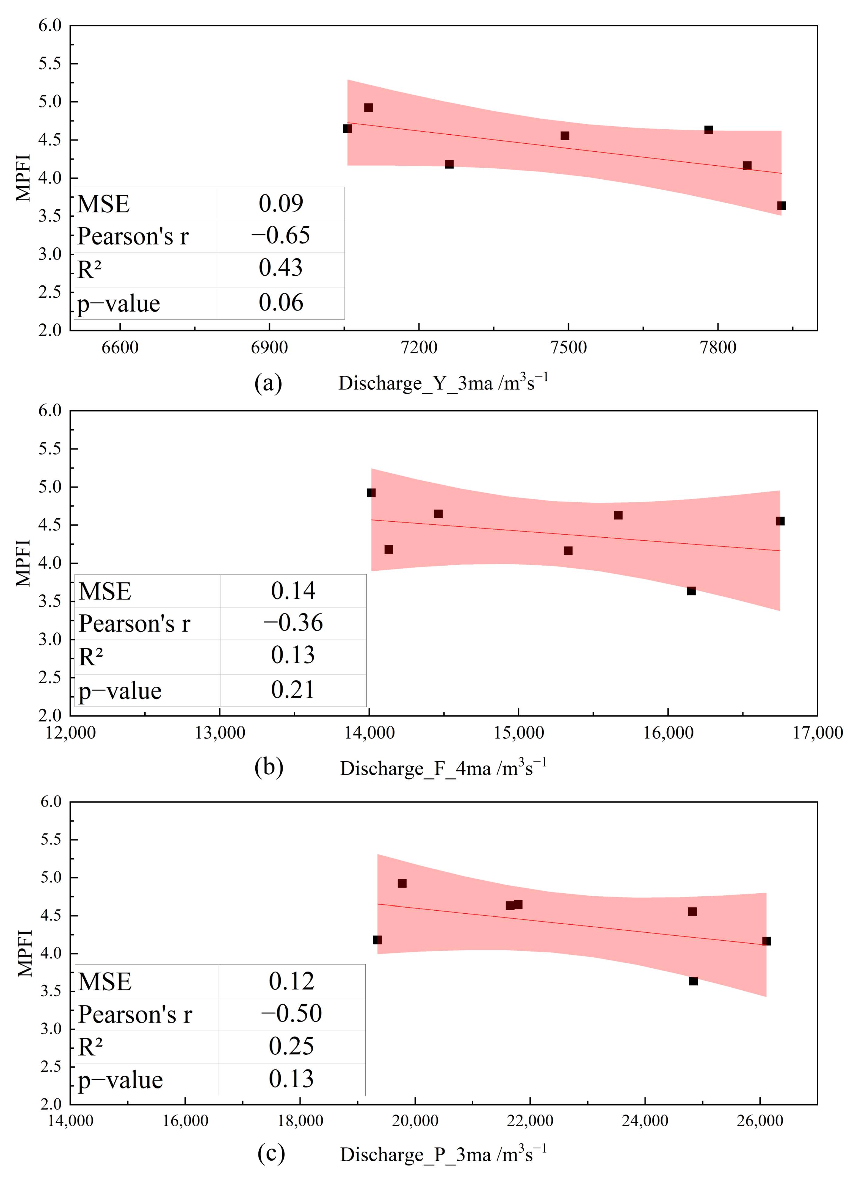
3.5. Response of the MPFI to the River Discharge
4. Discussion
5. Conclusions
Author Contributions
Funding
Data Availability Statement
Acknowledgments
Conflicts of Interest
Abbreviations
| MPFI | Modified Plan Form Index |
| BI | Braiding intensity indices |
Appendix A
References
- Bhuyan, N.; Sharma, Y.; Sajjad, H.; Ahmed, R. Estimating Bank-Line Migration of the Brahmaputra River in the Middle Brahmaputra Floodplains of Assam, India Using Digital Shoreline Analysis System. Environ. Earth Sci. 2023, 82, 385. [Google Scholar] [CrossRef]
- Saikia, L.; Mahanta, C.; Mukherjee, A.; Borah, S.B. Erosion-Deposition and Land Use/Land Cover of the Brahmaputra River in Assam, India. J. Earth Syst. Sci. 2019, 128, 211. [Google Scholar] [CrossRef]
- Akhtar, M.P.; Sharma, N.; Ojha, C.S.P. Braiding Process and Bank Erosion in the Brahmaputra River. Int. J. Sediment Res. 2011, 26, 431–444. [Google Scholar] [CrossRef]
- Pathan, S.A.; Sil, B.S. Prioritization of Soil Erosion Prone Areas in Upper Brahmaputra River Basin up to Majuli River Island. Geocarto Int. 2022, 37, 1999–2017. [Google Scholar] [CrossRef]
- Leopold, L.B.; Wolman, M.G. River Channel Patterns: Braided, Meandering, and Straight; U.S. Government Printing Office: Washington, DC, USA, 1957; Volume 9, pp. 39–85. [Google Scholar] [CrossRef]
- Parker, G. Cause and Characteristic Scales of Meandering and Braiding in Rivers. J. Fluid Mech. 1976, 76, 457–480. [Google Scholar] [CrossRef]
- Hsu, S.-Y.; Hsu, S.M. Morphological Evolution Mechanism of Gravel-Bed Braided River by Numerical Simulation on Da-Jia River. J. Hydrol. 2022, 613, 128222. [Google Scholar] [CrossRef]
- Li, Z.; Lu, H.; Chen, B.; You, Y.; Hu, X. A Review on Morphodynamic Processes and Mechanism of Braided Rivers. Adv. Water Sci. 2021, 32, 957–968. [Google Scholar]
- Storz-Peretz, Y.; Laronne, J.B.; Surian, N.; Lucia, A. Flow Recession as a Driver of the Morpho-Texture of Braided Streams. Earth Surf. Process. Landf. 2016, 41, 754–770. [Google Scholar] [CrossRef]
- Bridge, J.S. The Interaction between Channel Geometry, Water Flow, Sediment Transport and Deposition in Braided Rivers. Geol. Soc. Lond. Spec. Publ. 1993, 75, 13–71. [Google Scholar] [CrossRef]
- Limaye, A.B.; Grimaud, J.-L.; Lai, S.Y.J.; Foreman, B.Z.; Komatsu, Y.; Paola, C. Geometry and Dynamics of Braided Channels and Bars under Experimental Density Currents. Sedimentology 2018, 65, 1947–1972. [Google Scholar] [CrossRef]
- Redolfi, M. Sediment Transport and Morphology of Braided Rivers: Steady and Unsteady Regime. Doctoral Dissertation, Queen Mary University of London, London, UK, 2015. [Google Scholar]
- Nepal, S.; Shrestha, A.B. Impact of Climate Change on the Hydrological Regime of the Indus, Ganges and Brahmaputra River Basins: A Review of the Literature. Int. J. Water Resour. Dev. 2015, 31, 201–218. [Google Scholar] [CrossRef]
- Nury, A.H.; Sharma, A.; Marshall, L.; Cordery, I. Modelling Climate Change Impacts on the Brahmaputra Streamflow Resulting from Changes in Snowpack Attributes. J. Hydrol. 2021, 603, 126998. [Google Scholar] [CrossRef]
- Zhang, L.; Su, F.; Yang, D.; Hao, Z.; Tong, K. Discharge Regime and Simulation for the Upstream of Major Rivers over Tibetan Plateau. J. Geophys. Res.-Atmos. 2013, 118, 8500–8518. [Google Scholar] [CrossRef]
- Lutz, A.F.; Immerzeel, W.W.; Shrestha, A.B.; Bierkens, M.F.P. Consistent Increase in High Asia’s Runoff Due to Increasing Glacier Melt and Precipitation. Nat. Clim. Chang. 2014, 4, 587–592. [Google Scholar] [CrossRef]
- Roy, N.; Pandey, B.W.; Rani, U. Protecting the Vanishing Geo-Cultural Heritage of India: Case Study of Majuli Island in Assam. Int. J. Geoheritage Parks 2020, 8, 18–30. [Google Scholar] [CrossRef]
- Hooke, J.M.; Yorke, L. Channel Bar Dynamics on Multi-Decadal Timescales in an Active Meandering River. Earth Surf. Process. Landf. 2011, 36, 1910–1928. [Google Scholar] [CrossRef]
- Goswami, D.C. Brahmaputra River, Assam, India: Physiography, Basin Denudation, and Channel Aggradation. Water Resour. Res. 1985, 21, 959–978. [Google Scholar] [CrossRef]
- Prasujya, G.; Nayan, S. Spatio-Temporal Study of Morpho-Dynamics of the Brahmaputra River along Its Majuli Island Reach—ScienceDirect. Environ. Chall. 2021, 5, 100217. [Google Scholar] [CrossRef]
- Liu, J.; Li, W.; Zhao, W.; Yue, D.; Shu, Q.; Wang, W.; Gao, J.; Hou, X.; Wu, S. Evolution of Bars in Braided Rivers Controlled by Discharge Variability. Earth Sci. 2024, 49, 3516–3528. [Google Scholar] [CrossRef]
- Basumatary, H.; Sah, R.K.; Das, A.K. Bankline Dynamics and Their Effects on Protected Areas along the Brahmaputra River. Catena 2021, 197, 104947. [Google Scholar] [CrossRef]
- Sarma, J.N.; Phukan, M.K. Origin and Some Geomorphological Changes of Majuli Island of the Brahmaputra River in Assam, India. Geomorphology 2004, 60, 1–19. [Google Scholar] [CrossRef]
- Coleman, J. Brahmaputra River—Channel Processes and Sedimentation. Sediment. Geol. 1969, 3, 129–239. [Google Scholar] [CrossRef]
- Wu, B. Delayed Response Model for Bankfull Discharge of Alluvial Rivers. J. Hydraul. Eng. 2008, 39, 680–687. [Google Scholar] [CrossRef]
- Wu, B.; Li, L. Delayed Response Model for Bankfull Discharge Predictions in the Yellow River. Int. J. Sediment Res. 2011, 26, 445–459. [Google Scholar] [CrossRef]
- Takagi, T.; Oguchi, T.; Matsumoto, J.; Grossman, M.J.; Sarker, M.H.; Matin, M.A. Channel Braiding and Stability of the Brahmaputra River, Bangladesh, since 1967: GIS and Remote Sensing Analyses. Geomorphology 2007, 85, 294–305. [Google Scholar] [CrossRef]
- Lotsari, E.; Vaaja, M.; Flener, C.; Kaartinen, H.; Kukko, A.; Kasvi, E.; Hyyppa, H.; Hyyppa, J.; Alho, P. Annual Bank and Point Bar Morphodynamics of a Meandering River Determined by High-Accuracy Multitemporal Laser Scanning and Flow Data. Water Resour. Res. 2014, 50, 5532–5559. [Google Scholar] [CrossRef]
- Ali, A. Brahmaputra River Bank Erosion as a Major Geo-Environmental Problem in Lower Assam, India. J. Geol. Soc. India 2024, 100, 591–600. [Google Scholar] [CrossRef]
- Debnath, J.; Sahariah, D.; Lahon, D.; Nath, N.; Chand, K.; Meraj, G.; Kumar, P.; Singh, S.K.; Kanga, S.; Farooq, M. Assessing the Impacts of Current and Future Changes of the Planforms of River Brahmaputra on Its Land Use-Land Cover. Geosci. Front. 2023, 14, 101557. [Google Scholar] [CrossRef]
- Rao, M.P.; Cook, E.R.; Cook, B.I.; D’Arrigo, R.D.; Palmer, J.G.; Lall, U.; Woodhouse, C.A.; Buckley, B.M.; Uriarte, M.; Bishop, D.A.; et al. Seven Centuries of Reconstructed Brahmaputra River Discharge Demonstrate Underestimated High Discharge and Flood Hazard Frequency. Nat. Commun. 2020, 11, 6017. [Google Scholar] [CrossRef]
- Singh, S.K. Erosion and Weathering in the Brahmaputra River System. In Large Rivers: Geomorphology and Management; Wiley Publishing Company: Hoboken, NJ, USA, 2008; pp. 373–393. [Google Scholar] [CrossRef]
- Stewart, R.J.; Hallet, B.; Zeitler, P.K.; Malloy, M.A.; Allen, C.M.; Trippett, D. Brahmaputra Sediment Flux Dominated by Highly Localized Rapid Erosion from the Easternmost Himalaya. Geology 2008, 36, 711–714. [Google Scholar] [CrossRef]
- Bharasa, P.; Gayen, A. Safeguarding the Threatened Hydrogeo-Cultural Heritage of Majuli Island in Assam, India: A Case Study. In Proceedings of the National Conference on Challenges in Grounwater Development and Management, Raipur, India, 6–7 March 2020; IoP Publishing Ltd.: Bristol, UK, 2020; Volume 597, p. 012025. [Google Scholar]
- Ghosh, S.; Mandal, P.; Bera, B. Dynamics of Channel Bar Morphology on Multi-Decadal Timescales in a Braided River within Himalayan Foreland Basin, India. J. Earth Syst. Sci. 2023, 132, 168. [Google Scholar] [CrossRef]
- Devi, D.; Phukan, N.; Sarma, B. A Study of Erosional Depositional Activity and Land Use Mapping of Majuli River Island Using Landsat Data. In Hydrologic Modeling; Singh, V.P., Yadav, S., Yadava, R.N., Eds.; Springer: Singapore, 2018; Volume 81, pp. 187–200. [Google Scholar]
- Lahiri, S.K.; Sinha, R. Morphotectonic Evolution of the Majuli Island in the Brahmaputra Valley of Assam, India Inferred from Geomorphic and Geophysical Analysis. Geomorphology 2014, 227, 101–111. [Google Scholar] [CrossRef]
- Egozi, R.; Ashmore, P. Defining and Measuring Braiding Intensity. Earth Surf. Process. Landf. 2008, 33, 2121–2138. [Google Scholar] [CrossRef]
- Hooke, J. Morphodynamics of Active Meandering Rivers Reviewed in a Hierarchy of Spatial and Temporal Scales. Geomorphology 2023, 439, 108825. [Google Scholar] [CrossRef]
- Shen, H.; Wu, H.; Li, L.; Cao, B. Description Method for Variation of Sediment Transport Rate Based on Delayed Response Model-All Databases. J. Basic Sci. Eng. 2020, 28, 1294–1303. [Google Scholar] [CrossRef]
- Zhang, Y.; Zhong, D.; Wu, B. Multiple Temporal Scale Relationships of Bankfull Discharge with Streamflow and Sediment Transport in the Yellow River in China. Int. J. Sediment Res. 2013, 28, 496–510. [Google Scholar] [CrossRef]
- Wang, D.; Ma, Y.; Liu, X.; Huang, H.Q.; Huang, L.; Deng, C. Meandering-Anabranching River Channel Change in Response to Flow-Sediment Regulation: Data Analysis and Model Validation. J. Hydrol. 2019, 579, 124209. [Google Scholar] [CrossRef]
- Yang, Y.; Pan, M.; Lin, P.; Beck, H.E.; Zeng, Z.; Yamazaki, D.; David, C.H.; Lu, H.; Yang, K.; Hong, Y.; et al. Global Reach-Level 3-Hourly River Flood Reanalysis (1980–2019). Bull. Amer. Meteorol. Soc. 2021, 102, E2086–E2105. [Google Scholar] [CrossRef]
- Lei, X.; Ke, L.; Yong, B.; Zhang, J.; Cao, Q. Evaluation of River Water Level Monitoring from Satellite Radar Altimetry Datasets over Chinese Rivers. Remote Sens. Technol. Appl. 2022, 37, 61–72. [Google Scholar] [CrossRef]
- Wang, S.; Cui, D.; Xu, J. Monitoring and Analysis of Water Surface Slope of the Yarlung Zangbo River Based on Remote Sensing. Water 2022, 14, 3304. [Google Scholar] [CrossRef]
- Da Silva, J.S.; Calmant, S.; Seyler, F.; Rotunno Filho, O.C.; Cochonneau, G.; Mansur, W.J. Water Levels in the Amazon Basin Derived from the ERS 2 and ENVISAT Radar Altimetry Missions. Remote Sens. Environ. 2010, 114, 2160–2181. [Google Scholar] [CrossRef]
- Normandin, C.; Frappart, F.; Diepkile, A.T.; Marieu, V.; Mougin, E.; Blarel, F.; Lubac, B.; Braquet, N.; Ba, A. Evolution of the Performances of Radar Altimetry Missions from ERS-2 to Sentinel-3A over the Inner Niger Delta. Remote Sens. 2018, 10, 833. [Google Scholar] [CrossRef]
- Gehring, J.; Duvvuri, B.; Beighley, E. Deriving River Discharge Using Remotely Sensed Water Surface Characteristics and Satellite Altimetry in the Mississippi River Basin. Remote Sens. 2022, 14, 3541. [Google Scholar] [CrossRef]
- Beaudoing, H.; Rodell, M. GES DISC Dataset: GLDAS Noah Land Surface Model L4 Monthly 0.25 x 0.25 Degree; Version 2.1 (GLDAS_NOAH025_M 2.1); NASA Goddard Earth Sciences Data and Information Services Center: Greenbelt, MD, USA, 2020. [Google Scholar]
- Rodell, M.; Houser, P.R.; Jambor, U.; Gottschalck, J.; Mitchell, K.; Meng, C.J.; Arsenault, K.; Cosgrove, B.; Radakovich, J.; Bosilovich, M.; et al. The Global Land Data Assimilation System. Bull. Amer. Meteorol. Soc. 2004, 85, 381–394. [Google Scholar] [CrossRef]
- Bertoldi, W.; Zanoni, L.; Tubino, M. Planform Dynamics of Braided Streams. Earth Surf. Process. Landf. 2009, 34, 547–557. [Google Scholar] [CrossRef]
- Hong, L.B.; Davies, T.R.H. A Study of Stream Braiding: Summary. Geol. Soc. Am. Bull. 1979, 90, 1094. [Google Scholar] [CrossRef]
- Sharma, N. Mathematical Modelling and Braid Indicators. In The Brahmaputra Basin Water Resources; Springer: Berlin/Heidelberg, Germany, 2004; Volume 47, pp. 229–260. [Google Scholar] [CrossRef]
- Gao, C.; Wang, S. Distribution Rule of Active Channels Under Different Discharge of Anastomosing Reaches in the Tibetan Plateau of the Yellow River. Sci. Geogr. Sin. 2018, 38, 618–627. [Google Scholar] [CrossRef]
- Li, Z.; Lu, H.; Gao, P.; You, Y.; Hu, X. Characterizing Braided Rivers in Two Nested Watersheds in the Source Region of the Yangtze River on the Qinghai-Tibet Plateau. Geomorphology 2020, 351, 106945. [Google Scholar] [CrossRef]
- Liu, B.; Wang, S. Planform Characteristics and Development of Interchannel Wetlands in a Gravel-Bed Anastomosing River, Maqu Reach of the Upper Yellow River. J. Geogr. Sci. 2017, 27, 1376–1388. [Google Scholar] [CrossRef]
- Zanoni, L.; Gurnell, A.; Drake, N.; Surian, N. Island Dynamics in a Braided River from Analysis of Historical Maps and Air Photographs. River Res. Appl. 2008, 24, 1141–1159. [Google Scholar] [CrossRef]
- Wu, B.; Zheng, S.; Thorne, C.R. A General Framework for Using the Rate Law to Simulate Morphological Response to Disturbance in the Fluvial System. Prog. Phys. Geogr. 2012, 36, 575–597. [Google Scholar] [CrossRef]
- Li, L.; Wu, B.; Hou, S. Application of Delayed Response Model to Bankfull Discharge in the Inner Mongolia Reach of Yellow River. J. Hydroelectr. Eng. 2011, 30, 70–77. [Google Scholar] [CrossRef]
- Li, X.; Ren, J.; Xu, Q.; Yuan, J.; Zhang, W. Impact of Cascade Reservoirs on the Delayed Response Behaviour of Sedimentation in the Three Gorges Reservoir. J. Geogr. Sci. 2023, 33, 576–598. [Google Scholar] [CrossRef]
- Wang, H.; Lu, Y.; Yao, S.; Zuo, L.; Liu, H. Bank and Point Bar Morphodynamics in the Lower Jingjiang Reach of the Yangtze River in Response to the Three Gorges Project. J. Geogr. Sci. 2022, 32, 1530–1556. [Google Scholar] [CrossRef]
- Zheng, S.; Wang, H.; Wu, B. Delayed Morphological Adjustment of the Yellow and Lower Wei Rivers Upstream of the Sanmenxia Dam at Multi-Temporal Scales. Catena 2022, 212, 106035. [Google Scholar] [CrossRef]
- Kotoky, P.; Bezbaruah, D.; Borah, G.C.; Sarma, J.N. Do Node Points Play a Role in Flood Proliferation? Curr. Sci. 2009, 96, 1457–1460. [Google Scholar]
- Li, Z.; Yuan, X.; Yu, G. Characteristics and Geomorphologic Significance of Channel Longitudinal Profile in the Yarlung Tsangpo River Basin. J. Sediment Res. 2020, 45, 67–73. [Google Scholar]
- Li, X.; Zhu, L.; Chen, D.; Liu, M. Experimental Study on the Formation and Evolution of a Braided Channel with “Lotus Roots”. Adv. Water Sci. 2018, 29, 810–819. [Google Scholar] [CrossRef]
- Han, K.; Sun, J.; Lin, B.; Huang, Z.; Shi, X. Large-Scale Modelling of Highly Braided and Laterally Confined Reach of a Sand-Bed River. Earth Surf. Process. Landf. 2023, 48, 1557–1572. [Google Scholar] [CrossRef]
- Saha, U.D.; Saheb, A.M.; Islam, A.; Barman, S.D.; Dutt, S.; Islam, A.R.M.T. Characterizing the Trend of Channel Braiding of a Tropical Transboundary River Using Spatial Growth Component Analysis and ARIMA Model. Adv. Space Res. 2022, 70, 1773–1794. [Google Scholar] [CrossRef]
- Xia, J.; Jiang, Q.; Deng, S.; Zhou, M.; Cheng, Y.; Li, Z.; Wang, Z. Morphological Characteristics and Evolution Processes of Sharp Bends in the Lower Yellow River. Catena 2022, 210, 105936. [Google Scholar] [CrossRef]
- Graf, W.L. Channel Instability in a Braided, Sand Bed River. Water Resour. Res. 1981, 17, 1087–1094. [Google Scholar] [CrossRef]
- Hooke, J.M. Variations in Flood Magnitude–Effect Relations and the Implications for Flood Risk Assessment and River Management. Geomorphology 2015, 251, 91–107. [Google Scholar] [CrossRef]
- Uhe, P.F.; Mitchell, D.M.; Bates, P.D.; Sampson, C.C.; Smith, A.M.; Islam, A.S. Enhanced Flood Risk with 1.5 °C Global Warming in the Ganges–Brahmaputra–Meghna Basin. Environ. Res. Lett. 2019, 14, 074031. [Google Scholar] [CrossRef]
- Liu, Y. Ecological and Environmental Impacts of Major Hydropower Projects in the Qinghai–Tibet Plateau. Master’s Thesis, North China Electric Power University, Beijing, China, 2020. [Google Scholar]
- Copernicus Climate Change Service. Land Cover Classification Gridded Maps from 1992 to Present Derived from Satellite Observations; Copernicus Climate Change Service: Reading, UK, 2019. [Google Scholar]


| Satellite/Sensor | Number | Date | Spatial Resolution | Temporal Resolution | Monthly Average Discharge/m3s−1 | Water Level a/m |
|---|---|---|---|---|---|---|
| Landsat 4–5 TM | 135/041 | 27 December 1990 | 30 m | 16 days | 3450 | 72.36 |
| Landsat 4–5 TM | 135/041 | 23 November 1995 | 30 m | 16 days | 6013 | 73.68 |
| Landsat 7 ETM | 135/041 | 28 November 2000 | 30 m | 16 days | 6442 | 73.85 |
| Landsat 7 ETM | 135/041 | 10 November 2005 | 30 m | 16 days | 6401 | 73.83 |
| Landsat 7 ETM | 135/041 | 24 November 2010 | 30 m | 16 days | 7445 | 72.75 |
| Landsat 8 OLI | 135/041 | 30 November 2015 | 30 m | 16 days | 5131 | 71.76 |
| Landsat 8 OLI | 135/041 | 29 December 2020 | 30 m | 16 days | 3006 | 71.31 |
| Pearson’s r | Pearson’s r | Pearson’s r | |||
|---|---|---|---|---|---|
| Discharge_Y | −0.43 | Discharge_F | 0.11 | Discharge_P | 0.22 |
| Discharge_Y_2ma | −0.28 | Discharge_F_2ma | −0.04 | Discharge_P_2ma | −0.25 |
| Discharge_Y_3ma | −0.65 * | Discharge_F_3ma | −0.13 | Discharge_P_3ma | −0.50 |
| Discharge_Y_4ma | −0.28 | Discharge_F_4ma | −0.36 | Discharge_P_4ma | −0.48 |
| Discharge_Y_5ma | −0.03 | Discharge_F_5ma | −0.11 | Discharge_P_5ma | −0.24 |
| Discharge_Y_6ma | −0.28 | Discharge_F_6ma | −0.07 | Discharge_P_6ma | −0.24 |
| Discharge_Y_7ma | −0.14 | Discharge_F_7ma | −0.29 | Discharge_P_7ma | −0.36 |
| Discharge_Y_8ma | 0.09 | Discharge_F_8ma | −0.15 | Discharge_P_8ma | −0.28 |
| Attribute | Discharge | |||
|---|---|---|---|---|
| Winter | Snowmelt Period | Flood Season | ||
| Precipitation | Last winter | 0.15 | 0.06 | 0.12 |
| Snowmelt period | 0.66 *** | 0.35 ** | ||
| Flood season | 0.68 *** | |||
| Temperature | Last winter | −0.03 | 0.16 | 0.05 |
| Snowmelt period | 0.22 * | 0.11 | ||
| Flood season | −0.07 | |||
Disclaimer/Publisher’s Note: The statements, opinions and data contained in all publications are solely those of the individual author(s) and contributor(s) and not of MDPI and/or the editor(s). MDPI and/or the editor(s) disclaim responsibility for any injury to people or property resulting from any ideas, methods, instructions or products referred to in the content. |
© 2025 by the authors. Licensee MDPI, Basel, Switzerland. This article is an open access article distributed under the terms and conditions of the Creative Commons Attribution (CC BY) license (https://creativecommons.org/licenses/by/4.0/).
Share and Cite
Xue, Q.; He, L.; Tang, Q.; Xu, X.; Chen, D.; Wright, N.G.; Islam, G.M.T.; Baniya, B.; Islam, A.K.M.S.; Chowdhury, A.I.A.; et al. Planform Change and Its Delayed Response to Discharge in an Active Braided River Reach: Majuli Island Reach of the Brahmaputra River. Remote Sens. 2025, 17, 944. https://doi.org/10.3390/rs17060944
Xue Q, He L, Tang Q, Xu X, Chen D, Wright NG, Islam GMT, Baniya B, Islam AKMS, Chowdhury AIA, et al. Planform Change and Its Delayed Response to Discharge in an Active Braided River Reach: Majuli Island Reach of the Brahmaputra River. Remote Sensing. 2025; 17(6):944. https://doi.org/10.3390/rs17060944
Chicago/Turabian StyleXue, Qiange, Li He, Qiuhong Tang, Ximeng Xu, Dong Chen, Nigel G. Wright, G. M. Tarekul Islam, Binod Baniya, A. K. M. Saiful Islam, Ahmed Ishtiaque Amin Chowdhury, and et al. 2025. "Planform Change and Its Delayed Response to Discharge in an Active Braided River Reach: Majuli Island Reach of the Brahmaputra River" Remote Sensing 17, no. 6: 944. https://doi.org/10.3390/rs17060944
APA StyleXue, Q., He, L., Tang, Q., Xu, X., Chen, D., Wright, N. G., Islam, G. M. T., Baniya, B., Islam, A. K. M. S., Chowdhury, A. I. A., & Tang, Y. (2025). Planform Change and Its Delayed Response to Discharge in an Active Braided River Reach: Majuli Island Reach of the Brahmaputra River. Remote Sensing, 17(6), 944. https://doi.org/10.3390/rs17060944