
Evaluation of the Geomorphon Approach for Extracting Troughs in Polygonal Patterned Ground Across Different Permafrost Environments

 ,
,  , ,
, , 
Abstract
1. Introduction
2. Materials and Methods
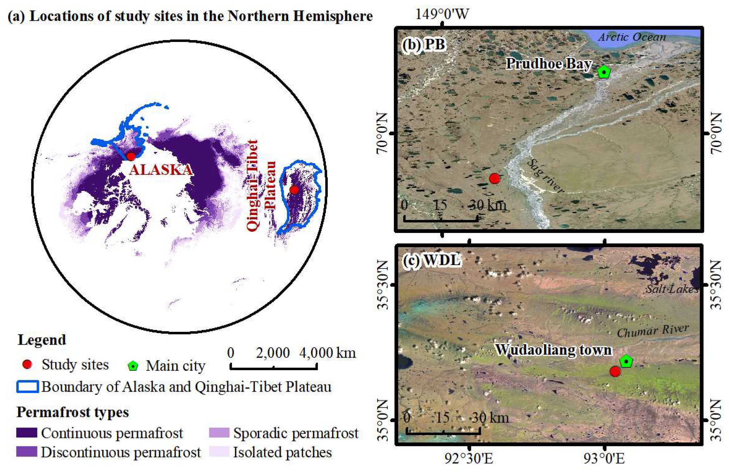
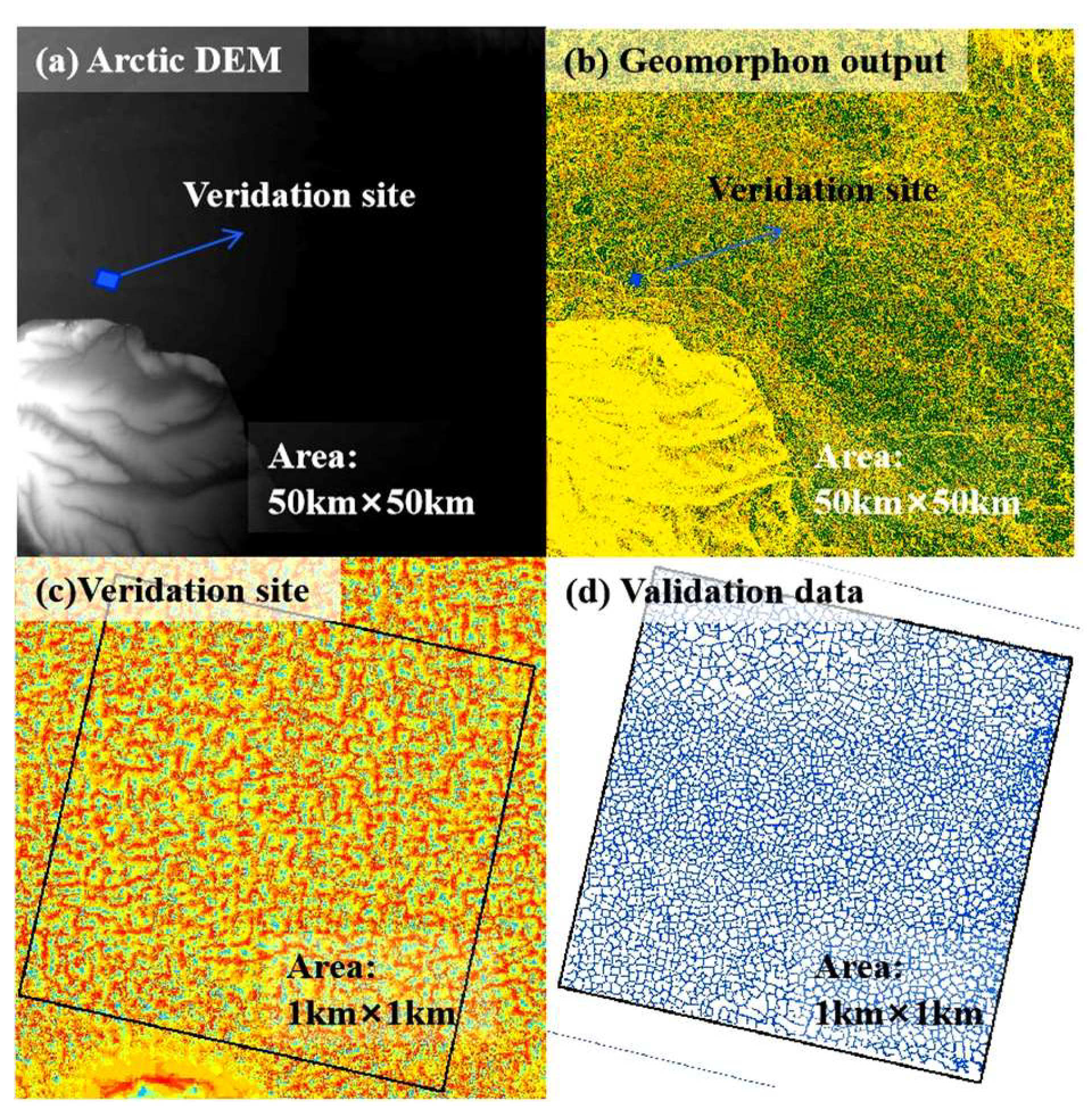
2.1. Study Area
2.2. Drone DEM Data Acquisition and Pre-Processing
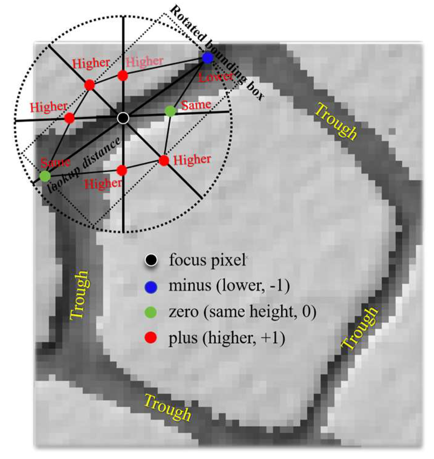
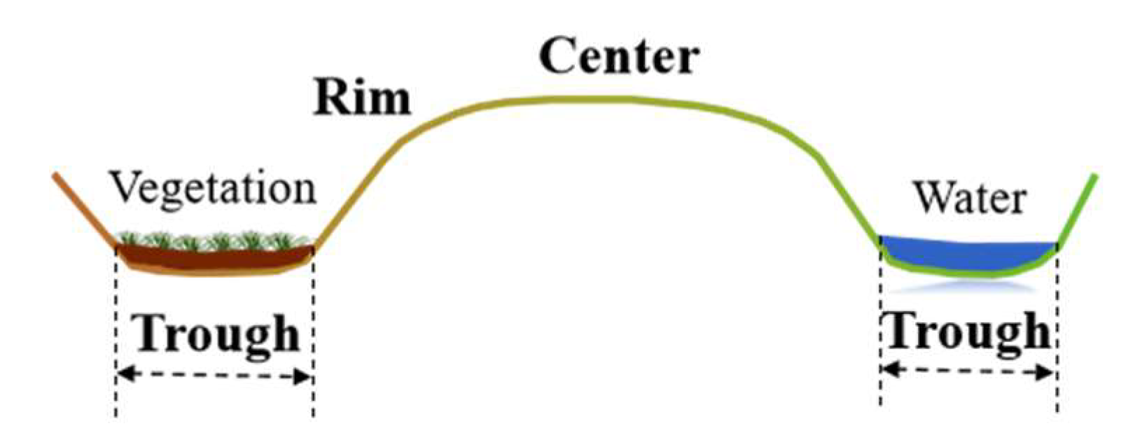
2.3. Trough Classification Mapping Based on Geomorphon and Traditional Methods
2.4. Accuracy Assessment
3. Results
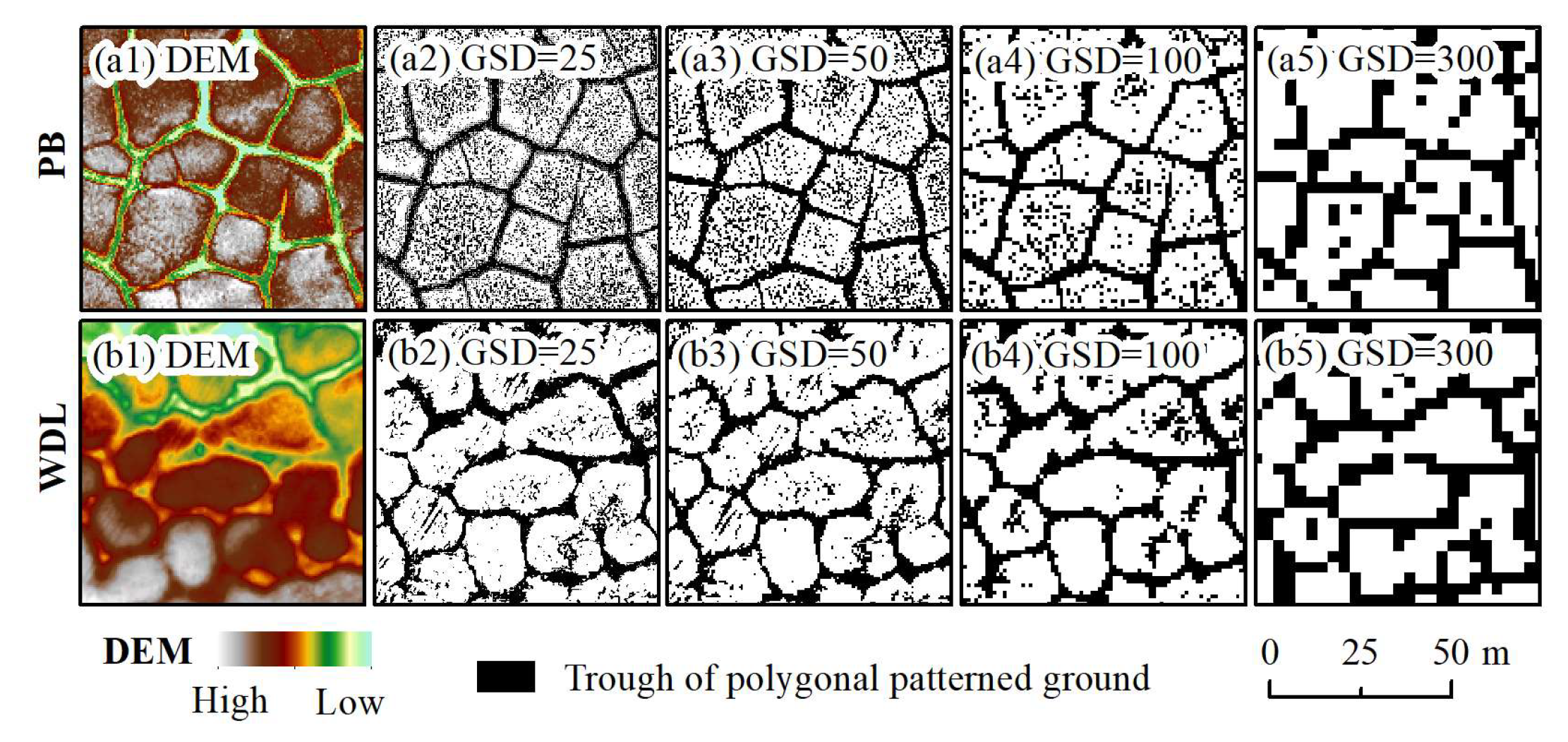
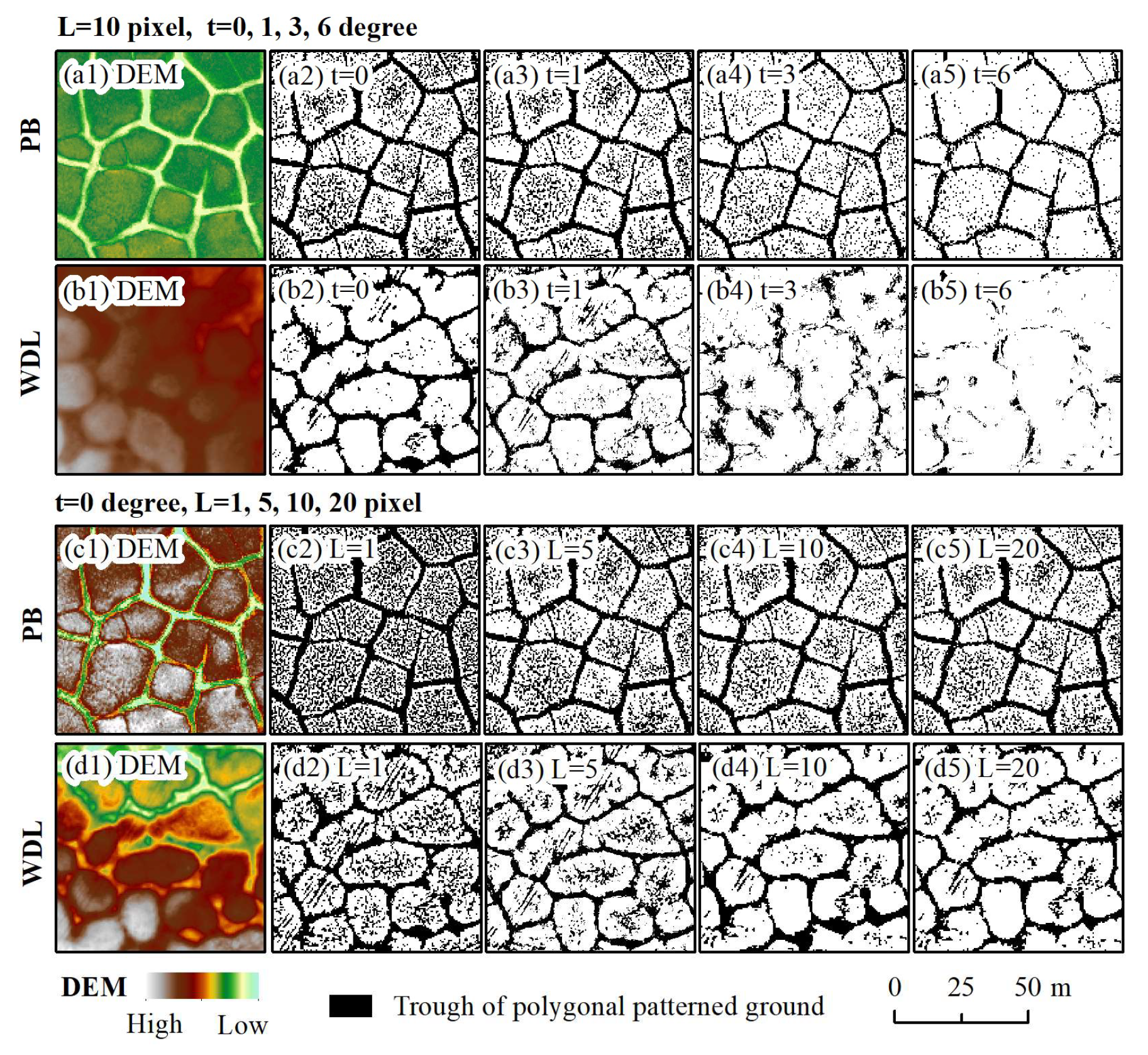
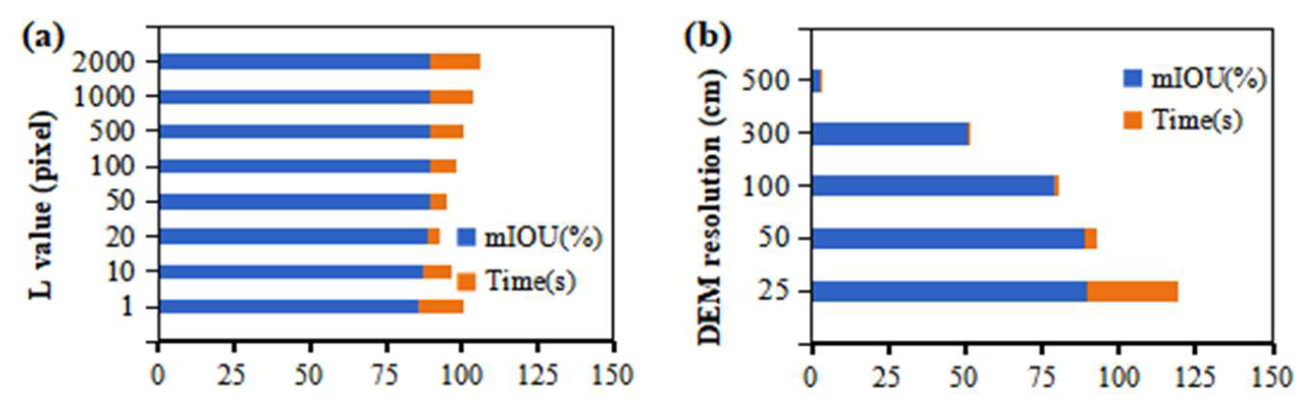
3.1. Influence of L, t Parameters, and DEM Resolution on Geomorphon Models
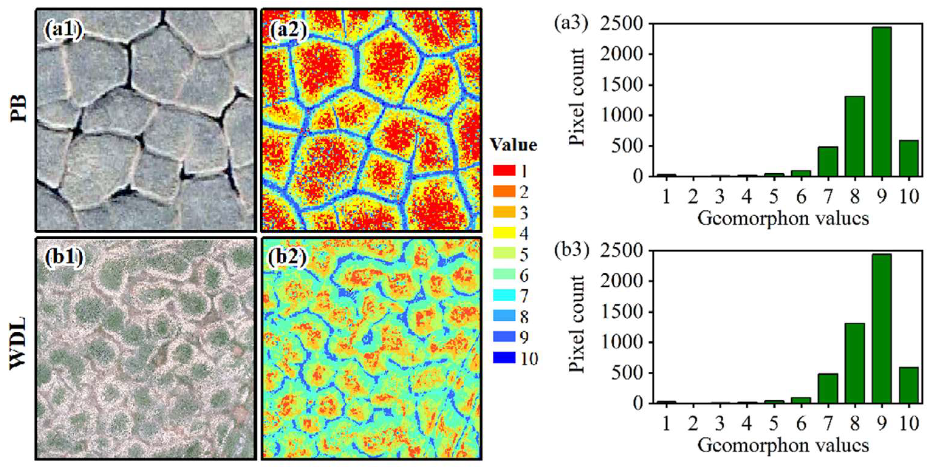
3.2. Trough Recognition Using Geomorphon Method
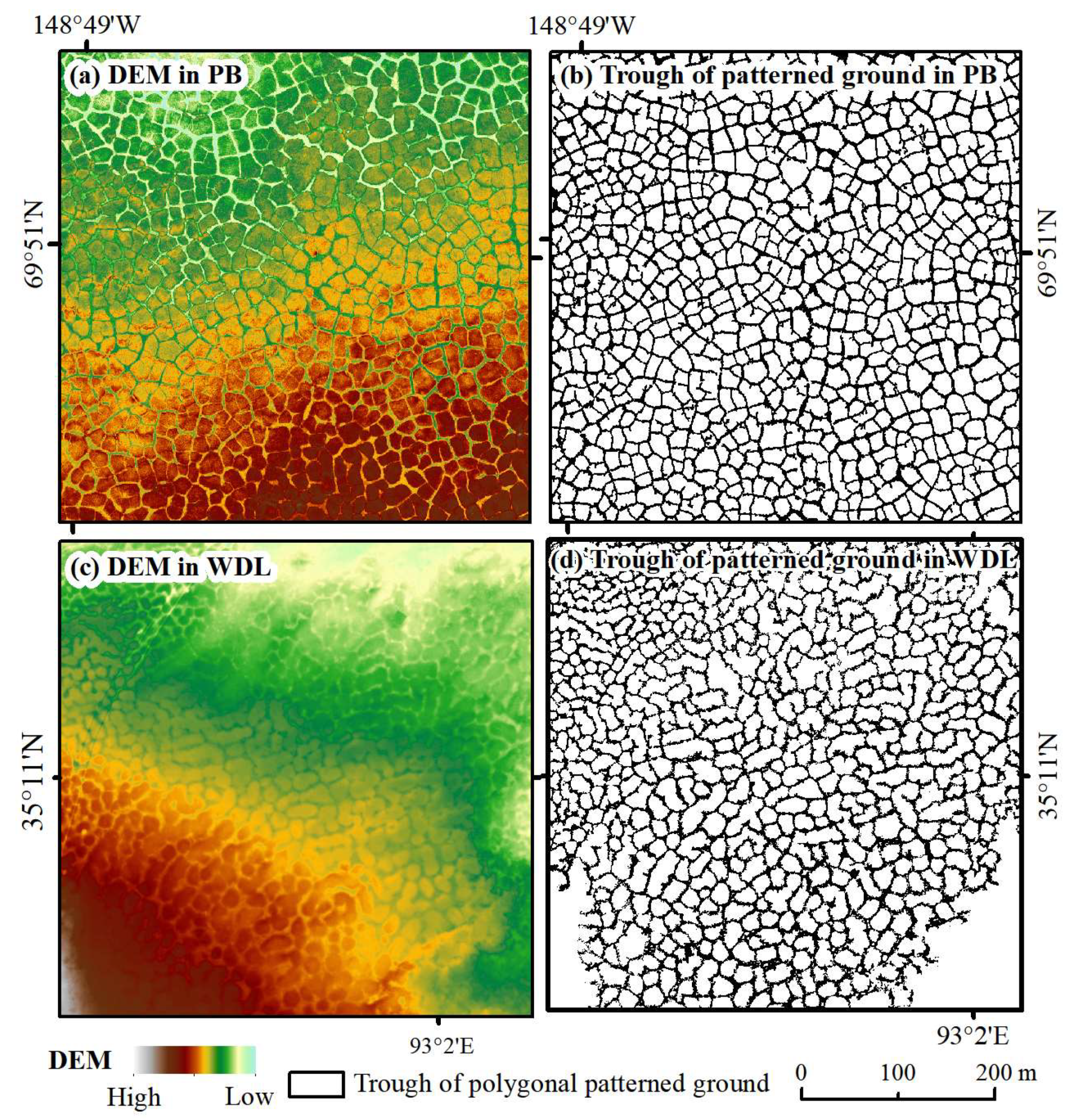
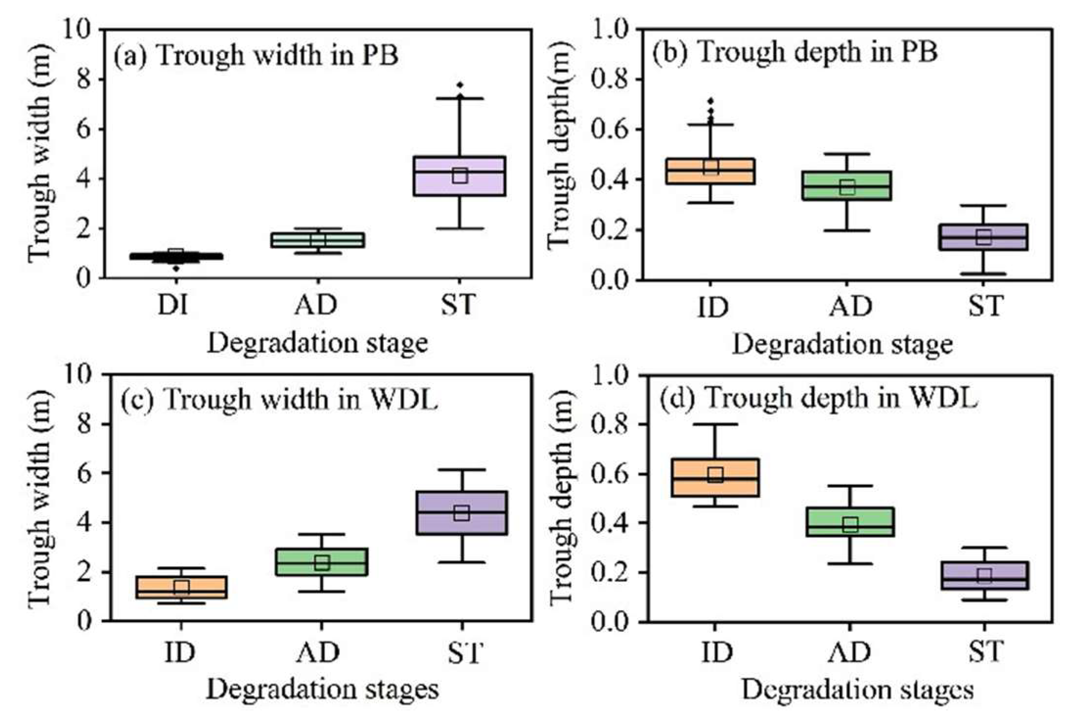
3.3. Trough Maps and Heterogeneous Trough Features
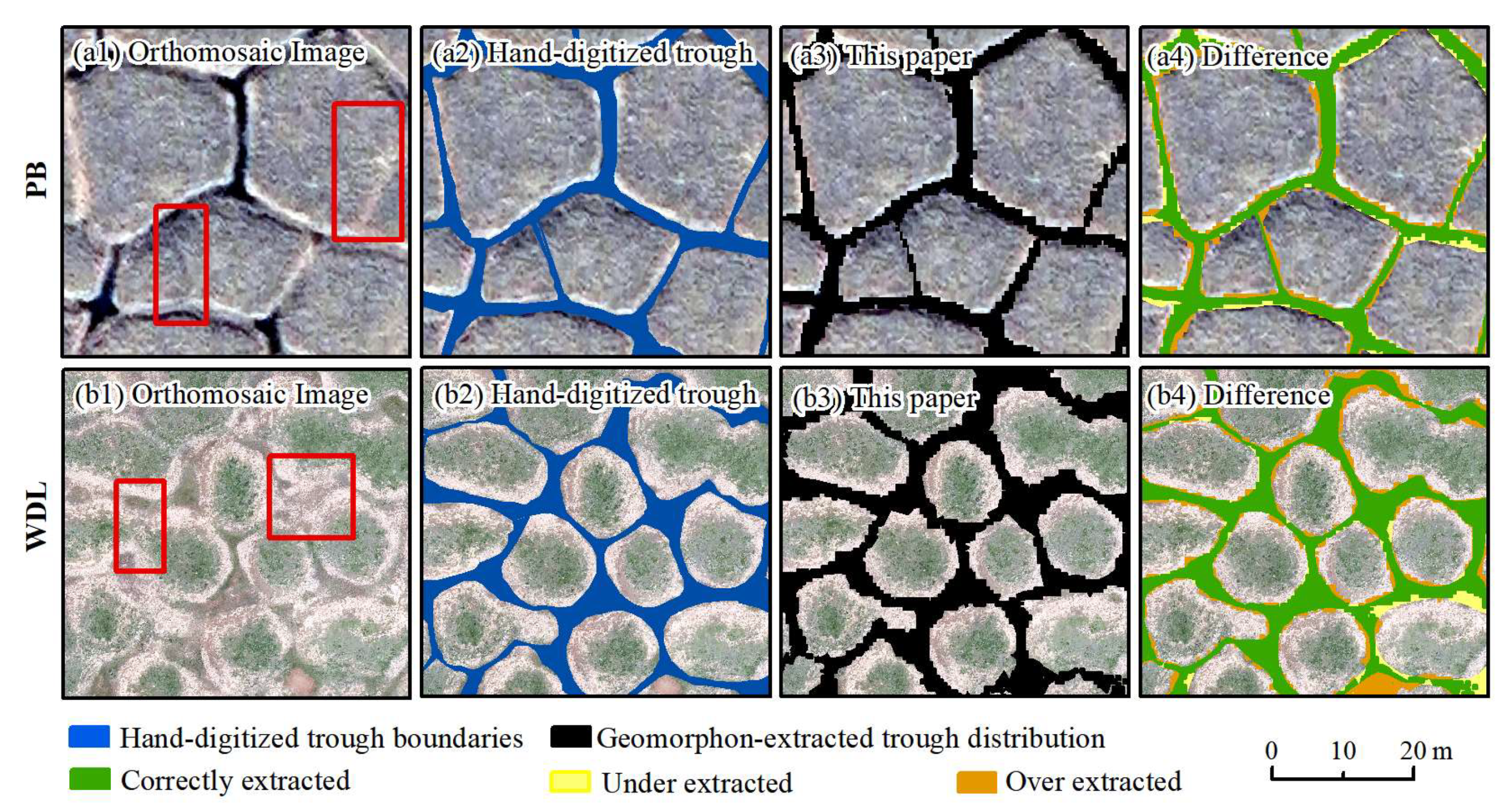
3.4. Accuracy Assessment for Trough Extraction
4. Discussions
4.1. Potential Influencing Factors Associated with Trough Classification Accuracy
4.2. Comparison to Polygon-Level Delineation Method
4.3. Comparison to Other Terrain Classification Indices
4.4. Limitations and Future Research
5. Conclusions
- (1)
- We represents a novel technique that allows for high-precision trough mapping. We found that the Geomorphon model with a DEM resolution of 50 cm, t value of 0°, and L value of 20 produced the trough classification maps with the highest accuracy, achieving mIOU scores of 0.89 and 0.84 and F1 Scores of 0.90 and 0.87 for the PB and WDL sites, respectively.
- (2)
- At least 18.0% of the PPG landscape in PB and 15.7% of that in WDL is covered by troughs, respectively. The statistical analysis indicated that the trough width and depth exhibited significant spatial heterogeneity at the meter scale. In addition, this study highlights how the spatial variability in PPG degradation is associated with trough features, propelling future pan-Arctic studies of PPG evolution.
- (3)
- Compared to the polygon-level delineation method, the spatial heterogeneity in troughs produced by the Geomorphon method can quantify the degradation states of PPG. In addition, traditional terrain indices for trough classification have limitations in representing the complexity of landforms, while the Geomorphon approach provides a direct trough classification map. This shows improvements in the scientific reproducibility when compared with different permafrost environments in PB in the Arctic and the WDL on the QTP.
Author Contributions
Funding
Data Availability Statement
Acknowledgments
Conflicts of Interest
References
- French, H.M. The Periglacial Environment; John Wiley & Sons: Hoboken, NJ, USA, 2017. [Google Scholar]
- Romanovskij, N.N. Distribution of recently active ice and soil wedges in the USSR. In Field and Theory; University of British Columbia Press: Vancouver, BC, Canada, 1985; pp. 154–165. [Google Scholar] [CrossRef]
- Mackay, J.R.; Burn, C.R. The first 20 years (1978–1979 to 1998–1999) of ice-wedge growth at the Illisarvik experimental drained lake site, western Arctic coast, Canada. Can. J. Earth Sci. 2002, 39, 95–111. [Google Scholar] [CrossRef]
- Jin, H.; Vandenberghe, J.; Luo, D.; Harris, S.A.; He, R.; Chen, X.; Jin, X.; Wang, Q.; Zhang, Z.; Spektor, V.; et al. Quaternary Permafrost in China: Framework and Discussions. Quaternary 2020, 3, 32. [Google Scholar] [CrossRef]
- Karjalainen, O.; Luoto, M.; Aalto, J.; Etzelmüller, B.; Grosse, G.; Jones, B.M.; Lilleøren, K.S.; Hjort, J. High potential for loss of permafrost landforms in a changing climate. Environ. Res. Lett. 2020, 15, 104065. [Google Scholar] [CrossRef]
- Olefeldt, D.; Goswami, S.; Grosse, G.; Hayes, D.; Hugelius, G.; Kuhry, P.; McGuire, A.D.; Romanovsky, V.E.; Sannel, A.B.K.; Schuur, E.A.G.; et al. Circumpolar distribution and carbon storage of thermokarst landscapes. Nat. Comm. 2016, 7, 13043. [Google Scholar] [CrossRef]
- Lewkowicz, A.G.; Way, R.G. Extremes of summer climate trigger thousands of thermokarst landslides in a High Arctic environment. Nat. Comm. 2019, 10, 1329. [Google Scholar] [CrossRef]
- Walker, D.A.; Raynolds, M.K.; Kanevskiy, M.Z.; Shur, Y.S.; Romanovsky, V.E.; Jones, B.M.; Buchhorn, M.; Jorgenson, M.T.; Sibík, J.; Breen, A.L.; et al. Cumulative Impacts of a Gravel Road and Climate Change in an Ice-Wedge Polygon Landscape, Prudhoe Bay, AK. Arctic Sci. 2022, 8, 1040–1066. [Google Scholar] [CrossRef]
- Nitzbon, J.; Westermann, S.; Langer, M.; Martin, L.C.; Strauss, J.; Laboor, S.; Boike, J. Fast response of cold ice-rich permafrost in northeast Siberia to a warming climate. Nat. Commun. 2020, 11, 2201. [Google Scholar] [CrossRef]
- Deng, H.; Zhang, Z.; Wu, Y. Accelerated permafrost degradation in thermokarst landforms in Qilian Mountains from 2007 to 2020 observed by SBAS-InSAR. Ecol. Indic. 2024, 159, 111724. [Google Scholar] [CrossRef]
- Godin, E.; Fortier, D.; Lévesque, E. Nonlinear thermal and moisture response of ice-wedge polygons to permafrost disturbance increases heterogeneity of high Arctic wetland. Biogeosciences 2016, 13, 1439–1452. [Google Scholar] [CrossRef]
- Liljedahl, A.K.; Boike, J.; Daanen, R.P.; Fedorov, A.N.; Frost, G.V.; Grosse, G.; Hinzman, L.D.; Iijma, Y.; Jorgenson, J.C.; Matveyeva, N.; et al. Pan-Arctic ice-wedge degradation in warming permafrost and its influence on tundra hydrology. Nat. Geosci. 2016, 9, 312–318. [Google Scholar] [CrossRef]
- Speetjens, N.J.; Berghuijs, W.R.; Wagner, J.; Vonk, J.E. Degradation of ice-wedge polygons leads to increased fluxes of water and DOC. Sci. Total Environ. 2024, 920, 170931. [Google Scholar] [CrossRef] [PubMed]
- Mackay, J.R. Air temperature, snow cover, creep of frozen ground, and the time of ice-wedge cracking, western Arctic coast. Can. J. Earth Sci. 1993, 30, 1720–1729. [Google Scholar] [CrossRef]
- Jones, E.L.; Hodson, A.J.; Redeker, K.R.; Christiansen, H.H.; Thornton, S.F.; Rogers, J. Biogeochemistry of low- and high-centered ice-wedge polygons in wetlands in Svalbard. Permafr. Periglac. Process 2023, 34, 35–369. [Google Scholar] [CrossRef]
- Abolt, C.J.; Young, M.H.; Atchley, A.L.; Brown, C.J. CNN-watershed: A machine-learning based tool for delineation and measurement of ice wedge polygons in high-resolution digital elevation models. Zenodo Repos. 2018, 25, 237–245. [Google Scholar]
- Ward Jones, M.K.; Pollard, W.H.; Amyot, F. Impacts of degrading ice-wedges on ground temperatures in a high Arctic polar desert system. J. Geophys. Res-Earth. 2020, 125, e2019JF005173. [Google Scholar] [CrossRef]
- Higgins, S.I.; Conradi, T.; Muhoko, E. Shifts in vegetation activity of terrestrial ecosystems attributable to climate trends. Nat. Geosci. 2023, 16, 147–153. [Google Scholar] [CrossRef]
- Painter, S.L.; Coon, E.T.; Khattak, A.J.; Jastrow, J.D. Drying of tundra landscapes will limit subsidence-induced acceleration of permafrost thaw. Proc. Natl. Acad. Sci. USA 2023, 120, e2212171120. [Google Scholar] [CrossRef]
- O’Neill, H.B.; Wolfe, S.A.; Duchesne, C.; Parker, R.J. Effect of surficial geology mapping scale on modelled ground ice in Canadian Shield terrain. Cryosphere 2024, 18, 2979–2990. [Google Scholar] [CrossRef]
- Lara, M.J.; McGuire, A.D.; Euskirchen, E.S.; Genet, H.; Yi, S.; Rutter, R.; Iversen, C.; Sloan, V.; Wullschleger, S.D. Local-scale Arctic tundra heterogeneity affects regional-scale carbon dynamics. Nat. Commun. 2020, 11, 1–10. [Google Scholar] [CrossRef]
- Nitzbon, J.; Langer, M.; Martin, L.C.; Westermann, S.; Schneider von Deimling, T.; Boike, J. Effects of multi-scale heterogeneity on the simulated evolution of ice-rich permafrost lowlands under a warming climate. Cryosphere 2021, 15, 1399–1422. [Google Scholar] [CrossRef]
- Nitzbon, J.; Schneider von Deimling, T.; Aliyeva, M.; Chadburn, S.E.; Grosse, G.; Laboor, S.; Lee, H.; Lohmann, G.; Steinert, N.J.; Stuenzi, S.M.; et al. No respite from permafrost-thaw impacts in the absence of a global tipping point. Nat. Clim. Change 2024, 14, 573–585. [Google Scholar] [CrossRef]
- Liljedahl, A.K.; Witharana, C.; Manos, E. The capillaries of the Arctic tundra. Nat. Water 2024, 2, 611–614. [Google Scholar] [CrossRef]
- Chartrand, S.M.; Jellinek, A.M.; Kukko, A.; Galofre, A.G.; Osinski, G.R.; Hinnard, S. High Arctic channel incision modulated by climate change and the emergence of polygonal ground. Nat. Commun. 2023, 14, 5297. [Google Scholar] [CrossRef]
- Wainwright, H.M.; Oktem, R.; Dafflon, B.; Dengel, S.; Curtis, J.B.; Torn, M.S.; Cherry, J.; Hubbard, S.S. High-Resolution Spatio-Temporal Estimation of Net Ecosystem Exchange in Ice-Wedge Polygon Tundra Using In Situ Sensors and Remote Sensing Data. Land 2021, 10, 722. [Google Scholar] [CrossRef]
- Jorgenson, M.T.; Kanevskiy, M.Z.; Jorgenson, J.C.; Liljedahl, A.; Shur, Y.; Epstein, H.; Kent, K.; Griffin, C.G.; Daanen, R.; Boldenow, M.; et al. Rapid transformation of tundra ecosystems from ice-wedge degradation. Glob. Planet. Change 2022, 216, 103921. [Google Scholar] [CrossRef]
- Braun, K.N.; Andresen, C.G. Heterogeneity in ice-wedge permafrost degradation revealed across spatial scales. Remote Sens. Environ. 2024, 311, 114299. [Google Scholar] [CrossRef]
- Abolt, C.J.; Young, M.H.; Atchley, A.L.; Harp, D.R.; Coon, E.T. Feedbacks between surface deformation and permafrost degradation in ice wedge polygons, Arctic Coastal Plain, Alaska. J. Geophys. Res-Earth 2020, 125, e2019JF005349. [Google Scholar] [CrossRef]
- Witharana, C.; Bhuiyan, M.A.E.; Liljedahl, A.K.; Kanevskiy, M.; Epstein, H.E.; Jones, B.M.; Dannen, R.; Griffin, C.G.; Kent, K.; Ward Jones, M.K. Understanding the synergies of deep learning and data fusion of multispectral and panchromatic high resolution commercial satellite imagery for automated ice-wedge polygon detection. ISPRS J. Photogramm. Remote Sens. 2020, 170, 174–191. [Google Scholar] [CrossRef]
- Merchant, M.; Bourgeau-Chavez, L.; Mahdianpari, M.; Brisco, B.; Obadia, M.; DeVries, B.; Berg, A. Arctic ice-wedge landscape mapping by CNN using a fusion of Radarsat constellation Mission and ArcticDEM. Remote Sens. Environ. 2024, 304, 114052. [Google Scholar] [CrossRef]
- Nitze, I.; Grosse, G.; Jones, B.M.; Romanovsky, V.E.; Boike, J. Remote sensing quantifies widespread abundance of permafrost region disturbances across the Arctic and Subarctic. Nat. Commun. 2018, 9, 5423. [Google Scholar] [CrossRef]
- Zhang, W.; Witharana, C.; Liljedahl, A.K.; Kanevskiy, M. Deep Convolutional Neural Networks for Automated Characterization of Arctic Ice-Wedge Polygons in Very High Spatial Resolution Aerial Imagery. Remote Sens. 2018, 10, 1487. [Google Scholar] [CrossRef]
- Bhuiyan, M.A.E.; Witharana, C.; Liljedahl, A.K. Use of Very High Spatial Resolution Commercial Satellite Imagery and Deep Learning to Automatically Map Ice-Wedge Polygons across Tundra Vegetation Types. J. Imaging 2020, 6, 137. [Google Scholar] [CrossRef] [PubMed]
- Kartoziia, A. Assessment of the Ice Wedge Polygon Current State by Means of UAV Imagery Analysis (Samoylov Island, the Lena Delta). Remote Sens. 2019, 11, 1627. [Google Scholar] [CrossRef]
- Witharana, C.; Bhuiyan, M.A.E.; Liljedahl, A.K.; Kanevskiy, M.; Jorgenson, T.; Jones, B.M.; Daanen, R.; Epstein, H.E.; Griffin, C.G.; Kent, K.; et al. An Object-Based Approach for Mapping Tundra Ice-Wedge Polygon Troughs from Very High Spatial Resolution Optical Satellite Imagery. Remote Sens. 2021, 13, 558. [Google Scholar] [CrossRef]
- Riihimäki, H.; Kemppinen, J.; Kopecký, M.; Luoto, M. Topographic wetness index as a proxy for soil moisture: The importance of flow-routing algorithm and grid resolution. Water Resour. Res. 2021, 57, e2021WR029871. [Google Scholar] [CrossRef]
- Huang, L.; Luo, J.; Lin, Z.; Niu, F.; Liu, L. Using deep learning to map retrogressive thaw slumps in the Beiluhe region (Tibetan Plateau) from CubeSat images. Remote Sens. Environ. 2020, 237, 111534. [Google Scholar] [CrossRef]
- Shukla, T.; Tang, W.; Trettin, C.C.; Chen, G.; Chen, S.; Allan, C. Quantification of microtopography in natural ecosystems using close-range remote sensing. Remote Sens. 2023, 15, 2387. [Google Scholar] [CrossRef]
- Jasiewicz, J.; Stepinski, T.F. Geomorphon—A pattern recognition approach to classification and mapping of landforms. Geomorphology 2013, 182, 147–156. [Google Scholar] [CrossRef]
- Maxwell, A.E.; Shobe, C.M. Land-surface parameters for spatial predictive mapping and modeling. Earth-Sci. Rev. 2022, 226, 103944. [Google Scholar] [CrossRef]
- Ngunjiri, M.W.; Libohova, Z.; Owens, P.R.; Schulze, D.G. Landform pattern recognition and classification for predicting soil types of the Uasin Gishu Plateau, Kenya. Catena 2020, 188, 104390. [Google Scholar] [CrossRef]
- Flynn, T.; Rozanov., A.; Ellis, F.; de Clercq, W.; Clarke, C. Farm-scale soil patterns derived from automated terrain classification. Catena 2020, 185, 104311. [Google Scholar] [CrossRef]
- Gioia, D.; Danese, M.; Corrado, G.; Di Leo, P.; Minervino Amodio, A.; Schiattarella, M. Assessing the prediction accuracy of geomorphon-based automated landform classification: An example from the ionian coastal belt of southern Italy. ISPRS Int. J. Geo-Inf. 2021, 10, 725. [Google Scholar] [CrossRef]
- Lou, P.; Wu, T.; Yin, G.; Chen, J.; Zhu, X.; Wu, X.; Li, R.; Yang, S. A novel framework for multiple thermokarst hazards risk assessment and controlling environmental factors analysis on the Qinghai-Tibet Plateau. CATENA 2024, 246, 108367. [Google Scholar] [CrossRef]
- Cignetti, M.; Godone, D.; Ferrari Trecate, D.; Baldo, M. New Paradigms for Geomorphological Mapping: A Multi-Source Approach for Landscape Characterization. Remote Sens. 2025, 17, 581. [Google Scholar] [CrossRef]
- Coria, R.D.; Brungard, C.; Vizgarra, A.L.; Moretti, L.M.; Schulz, G.A.; Rodríguez, D.M. Accuracy assessment of the geomorphon approach to detect ecological sites in the Dry Chaco region of Argentina. CATENA 2024, 246, 108409. [Google Scholar] [CrossRef]
- Kanevskiy, M.; Shur, Y.; Walker, D.A.; Jorgenson, T.; Raynolds, M.K.; Peirce, J.L.; Buchhorn, M.; Matyshak, G.; Bergstedt, H.; Breen, A.L.; et al. The shifting mosaic of ice-wedge degradation and stabilization in response to infrastructure and climate change, Prudhoe Bay Oilfield, Alaska, USA. Arctic Sci. 2022, 8, 498–530. [Google Scholar] [CrossRef]
- Jorgenson, M.T.; Kanevskiy, M.; Shur, Y.; Moskalenko, N.; Brown, D.R.N.; Wickland, K.; Striegl, R.; Koch, J. Role of ground ice dynamics and ecological feedbacks in recent ice wedge degradation and stabilization. J. Geophys. Res-Earth 2015, 120, 2280–2297. [Google Scholar] [CrossRef]
- Zhu, X.; Wu, T.; Chen, J.; Wu, X.; Wang, P.; Zou, D.; Yue, G.; Yan, X.; Ma, X.; Wang, D.; et al. Summer heat wave in 2022 led to rapid warming of permafrost in the central Qinghai-Tibet Plateau. NPJ. Clim. Atmos. Sci. 2024, 7, 216. [Google Scholar] [CrossRef]
- Zhao, L.; Zou, D.; Hu, G.; Wu, T.; Du, E.; Liu, G.; Xiao, Y.; Li, R.; Pang, Q.; Qiao, Y.; et al. A synthesis dataset of permafrost thermal state for the Qinghai-Tibet (Xizang) Plateau, China. Earth Syst. Sci. Data 2021, 13, 4207–4218. [Google Scholar] [CrossRef]
- Wang, L.; Liu, H. An efficient method for identifying and filling surface depressions in digital elevation models for hydrologic analysis and modelling. Int. J. Geogr. Inf. Sci. 2006, 20, 193–213. [Google Scholar] [CrossRef]
- Rettelbach, T.; Langer, M.; Nitze, I.; Jones, B.; Helm, V.; Freytag, J.C.; Grosse, G. A quantitative graph-based approach to monitoring ice-wedge trough dynamics in polygonal permafrost landscapes. Remote Sens. 2021, 13, 3098. [Google Scholar] [CrossRef]
- Al-Sababhah, N. Topographic Position Index to Landform Classification and Spatial Planning, Using GIS, for Wadi Araba, South West Jordan. Environ. Ecol. Res. 2023, 11, 79–101. [Google Scholar] [CrossRef]
- Goulden, T.; Hopkinson, C.; Jamieson, R.; Sterling, S. Sensitivity of DEM, slope, aspect and watershed attributes to LiDAR measurement uncertainty. Remote Sen. Environ. 2016, 179, 23–35. [Google Scholar] [CrossRef]
- Bühler, Y.; Christen, M.; Kowalski, J.; Bartelt, P. Sensitivity of snow avalanche simulations to digital elevation model quality and resolution. Ann. Glaciol. 2011, 52, 72–80. [Google Scholar] [CrossRef]
- Tuominen, S.; Pekkarinen, A. Performance of different spectral and textural aerial photograph features in multi-source forest inventory. Remote Sens. Environ. 2005, 94, 256–268. [Google Scholar] [CrossRef]
- Wickland, K.P.; Jorgenson, M.T.; Koch, J.C.; Kanevskiy, M.; Striegl, R. Carbon Dioxide and Methane Flux in a Dynamic Arctic Tundra Landscape: Decadal-Scale Impacts of Ice Wedge Degradation and Stabilization. Geophys. Res. Lett. 2020, 47, e2020GL089894. [Google Scholar] [CrossRef]
- Wolter, J.; Jones, B.M.; Fuchs, M.; Breen, A.; Bussmann, I.; Koch, B.; Lenz, J.; Myers-Smith, I.H.; Sachs, T.; Strauss, J.; et al. Post-drainage vegetation, microtopography and organic matter in Arctic drained lake basins. Environ. Res. Lett. 2024, 19, 045001. [Google Scholar] [CrossRef]
- Zhang, W.; Liljedahl, A.K.; Kanevskiy, M.; Epstein, H.E.; Jones, B.M.; Jorgenson, M.T.; Kent, K. Transferability of the Deep Learning Mask R-CNN Model for Automated Mapping of Ice-Wedge Polygons in High-Resolution Satellite and UAV Images. Remote Sens. 2020, 12, 1085. [Google Scholar] [CrossRef]
- Sun, Z.; Hu, Y.; Racoviteanu, A.; Liu, L.; Harrison, S.; Wang, X.; Cai, J.; Guo, X.; He, Y.; Yuan, H. TPRoGI: A comprehensive rock glacier inventory for the Tibetan Plateau using deep learning. Earth Syst. Sci. Data 2024, 16, 5703–5721. [Google Scholar] [CrossRef]
- Liu, B.; Wang, W.; Wu, Y.; Gao, X. Attention Swin Transformer UNet for Landslide Segmentation in Remotely Sensed Images. Remote Sens. 2024, 16, 4464. [Google Scholar] [CrossRef]
- Wang, X.; Wang, D.; Liu, C.; Zhang, M.; Xu, L.; Sun, T.; Li, W.; Cheng, S.; Dong, J. Refined Intelligent Landslide Identification Based on Multi-Source Information Fusion. Remote Sens. 2024, 16, 3119. [Google Scholar] [CrossRef]
- Marjani, M.; Mahdianpari, M.; Mohammadimanesh, F.; Gill, E.W. CVTNet: A Fusion of Convolutional Neural Networks and Vision Transformer for Wetland Mapping Using Sentinel-1 and Sentinel-2 Satellite Data. Remote Sens. 2024, 16, 2427. [Google Scholar] [CrossRef]
- Martínez-Carricondo, P.; Agüera-Vega, F.; Carvajal-Ramírez, F.; Mesas-Carrascosa, F.J.; García-Ferrer, A.; Pérez-Porras, F.J. Assessment of UAV-photogrammetric mapping accuracy based on variation of ground control points. Int. J. Appl. Earth Obs. 2018, 72, 1–10. [Google Scholar] [CrossRef]
- Schultz-Fellenz, E.S.; Swanson, E.M.; Sussman, A.J.; Coppersmith, R.T.; Kelley, R.E.; Miller, E.D.; Brandon, M.C.; Lavadie-Bulnes, A.F.; Cooley, J.R.; Vigil, S.R. High-resolution surface topographic change analyses to characterize a series of underground explosions. Remote Sens. Environ. 2020, 246, 111871. [Google Scholar] [CrossRef]
- Syzdykbayev, M.; Karimi, B.; Karimi, H.A. A Method for Extracting Some Key Terrain Features from Shaded Relief of Digital Terrain Models. Remote Sens. 2020, 12, 2809. [Google Scholar] [CrossRef]
- Nitze, I.; Van der Sluijs, J.; Barth, S.; Bernhard, P.; Huang, L.; Kizyakov, A.; Lara, L.M.; Nesterova, N.; Runge, A.; Veremeeva, A.; et al. A labeling intercomparison of retrogressive thaw slumps by a diverse group of domain experts. Permafr. Periglac. Process 2025, 36, 83–92. [Google Scholar] [CrossRef]
- Lousada, M.; Pina, P.; Vieira, G.; Bandeira, L.; Mora, C. Evaluation of the use of very high resolution aerial imagery for accurate ice-wedge polygon mapping (Adventdalen, Svalbard). Sci. Total Environ. 2018, 615, 1574–1583. [Google Scholar] [CrossRef]
- Taş, N.; Prestat, E.; Wang, S.; Wu, Y.; Ulrich, C.; Kneafsey, T.; Tringe, S.G.; Torn, M.S.; Hubbard, S.S.; Jansson, J.K. Landscape topography structures the soil microbiome in arctic polygonal tundra. Nat. Comm. 2018, 9, 777. [Google Scholar] [CrossRef]
- Kumar, J.; Collier, N.; Bisht, G.; Mills, R.T.; Thornton, P.E.; Iversen, C.M.; Romanovsky, V. Modeling the spatiotemporal variability in subsurface thermal regimes across a low-relief polygonal tundra landscape. Cryosphere 2016, 10, 2241–2274. [Google Scholar] [CrossRef]
- Gao, Z.; Zhang, C.; Liu, W.; Niu, F.; Wang, Y.; Lin, Z.; Yin, G.; Ding, Z.; Shang, Y.; Luo, J. Extreme degradation of alpine wet meadow decelerates soil heat transfer by preserving soil organic matter on the Qinghai-Tibet Plateau. J. Hydrol. 2025, 653, 132748. [Google Scholar] [CrossRef]
- Rettelbach, T.; Nitze, I.; Grünberg, I.; Hammar, J.; Schäffler, S.; Hein, D.; Gessner, M.; Bucher, T.; Brauchle, J.; Hartmann, J.; et al. Very high resolution aerial image orthomosaics, point clouds, and elevation datasets of select permafrost landscapes in Alaska and northwestern Canada. Earth Syst. Sci. Data 2024, 16, 5767–5798. [Google Scholar] [CrossRef]
- Jones, B.M.; Kanevskiy, M.Z.; Shur, Y.; Gaglioti, B.V.; Jorgenson, M.T.; Ward Jones, M.K.; Veremeeva, A.; Miller, E.A.; Jandt, R. Post-fire stabilization of thaw-affected permafrost terrain in northern Alaska. Sci. Rep. 2024, 14, 8499. [Google Scholar] [CrossRef] [PubMed]
- Pokharel, B.; Alvioli, M.; Lim, S. Assessment of earthquake-induced landslide inventories and susceptibility maps using slope unit-based logistic regression and geospatial statistics. Sci. Rep. 2021, 11, 21333. [Google Scholar] [CrossRef] [PubMed]
- Amatulli, G.; Domisch, S.; Tuanmu, M.N. A suite of global, cross-scale topographic variables for environmental and biodiversity modeling. Sci. Data. 2018, 5, 180040. [Google Scholar] [CrossRef] [PubMed]
- Lara, M.J.; Nitze, I.; Grosse, G.; Martin, P.; McGuire, A.D. Reduced arctic tundra productivity linked with landform and climate change interactions. Sci. Rep. 2018, 8, 2345. [Google Scholar] [CrossRef]


| Sites | Coordinates | Elevation | MAAT | MAP | ALT |
|---|---|---|---|---|---|
| PB | 69.8436°N, −148.8082°W | 82 m | −11.1 °C | 102.6 mm | 72 cm |
| WDL | 35.1382°N, 93.0389°E | 4660 m | −5.82 °C | 314.3 mm | 175–200 cm |
| Sites | Degradation Stages | Types | |||
|---|---|---|---|---|---|
| Undegraded | Degradation | Stabilization | Flat-Centered | High-Centered | |
| TW ≤ 1 m | 1 m < TW ≤ 2 m | TW > 2 m | TD ≤ 0.05 m | TD > 0.05 m | |
| PB | 75 | 125 | 130 | 82 | 218 |
| WDL | 53 | 120 | 137 | 68 | 252 |
| Sites | Trough Width (TW) | Trough Depth (TD) | |||
|---|---|---|---|---|---|
| Undegraded | Degradation | Stabilization | Flat-Centered | High-Centered | |
| TW ≤ 1 m | 1 m < TW ≤ 2 m | TW > 2 m | ≤0.05 m | 0.05 m | |
| PB | 17.82 | 30.83 | 51.3 | 3.8 | 93.2 |
| WDL | 11.75 | 17.86 | 70.37 | 5.71 | 96.4 |
| Sites | Trough Width (TW) | Trough Depth (TD) | ||||||||
|---|---|---|---|---|---|---|---|---|---|---|
| Undegraded | Degradation | Stabilization | Flat Centered | High Centered | ||||||
| TW ≤ 1 m | 1 m < TW ≤ 2 m | TW > 2 m | ≤0.05 m | 0.05 m | ||||||
| mIOU | F1 | mIOU | F1 | mIOU | F1 | mIOU | F1 | mIOU | F1 | |
| PB | 0.82 | 0.85 | 0.91 | 0.93 | 0.89 | 0.91 | 0.49 | 0.51 | 0.92 | 0.95 |
| WDL | 0.83 | 0.86 | 0.89 | 0.91 | 0.87 | 0.89 | 0.47 | 0.49 | 0.88 | 0.91 |
| Classification Methods | PB | WDL | ||
|---|---|---|---|---|
| Number | Completeness | Number | Completeness | |
| Manual delineation | 83 | 98.8 | 78 | 98.7 |
| Geomorphon | 79 | 98.5 | 11 | 98.0 |
| Closed depressions | 82 | 43.4 | 77 | 20.5 |
| SWI | 36 | 51.8 | 16 | 41.7 |
| TPI | 43 | 95.2 | 32 | 14.1 |
Disclaimer/Publisher’s Note: The statements, opinions and data contained in all publications are solely those of the individual author(s) and contributor(s) and not of MDPI and/or the editor(s). MDPI and/or the editor(s) disclaim responsibility for any injury to people or property resulting from any ideas, methods, instructions or products referred to in the content. |
© 2025 by the authors. Licensee MDPI, Basel, Switzerland. This article is an open access article distributed under the terms and conditions of the Creative Commons Attribution (CC BY) license (https://creativecommons.org/licenses/by/4.0/).
Share and Cite
Wen, A.; Wu, T.; Zhu, X.; Chen, J.; Shi, J.; Lou, P.; Wang, D.; Ma, X.; Wu, X. Evaluation of the Geomorphon Approach for Extracting Troughs in Polygonal Patterned Ground Across Different Permafrost Environments. Remote Sens. 2025, 17, 1040. https://doi.org/10.3390/rs17061040
Wen A, Wu T, Zhu X, Chen J, Shi J, Lou P, Wang D, Ma X, Wu X. Evaluation of the Geomorphon Approach for Extracting Troughs in Polygonal Patterned Ground Across Different Permafrost Environments. Remote Sensing. 2025; 17(6):1040. https://doi.org/10.3390/rs17061040
Chicago/Turabian StyleWen, Amin, Tonghua Wu, Xiaofan Zhu, Jie Chen, Jianzong Shi, Peiqing Lou, Dong Wang, Xin Ma, and Xiaodong Wu. 2025. "Evaluation of the Geomorphon Approach for Extracting Troughs in Polygonal Patterned Ground Across Different Permafrost Environments" Remote Sensing 17, no. 6: 1040. https://doi.org/10.3390/rs17061040
APA StyleWen, A., Wu, T., Zhu, X., Chen, J., Shi, J., Lou, P., Wang, D., Ma, X., & Wu, X. (2025). Evaluation of the Geomorphon Approach for Extracting Troughs in Polygonal Patterned Ground Across Different Permafrost Environments. Remote Sensing, 17(6), 1040. https://doi.org/10.3390/rs17061040